Subdivision Staff Report
|
|
|
- Britney Thompson
- 5 years ago
- Views:
Transcription
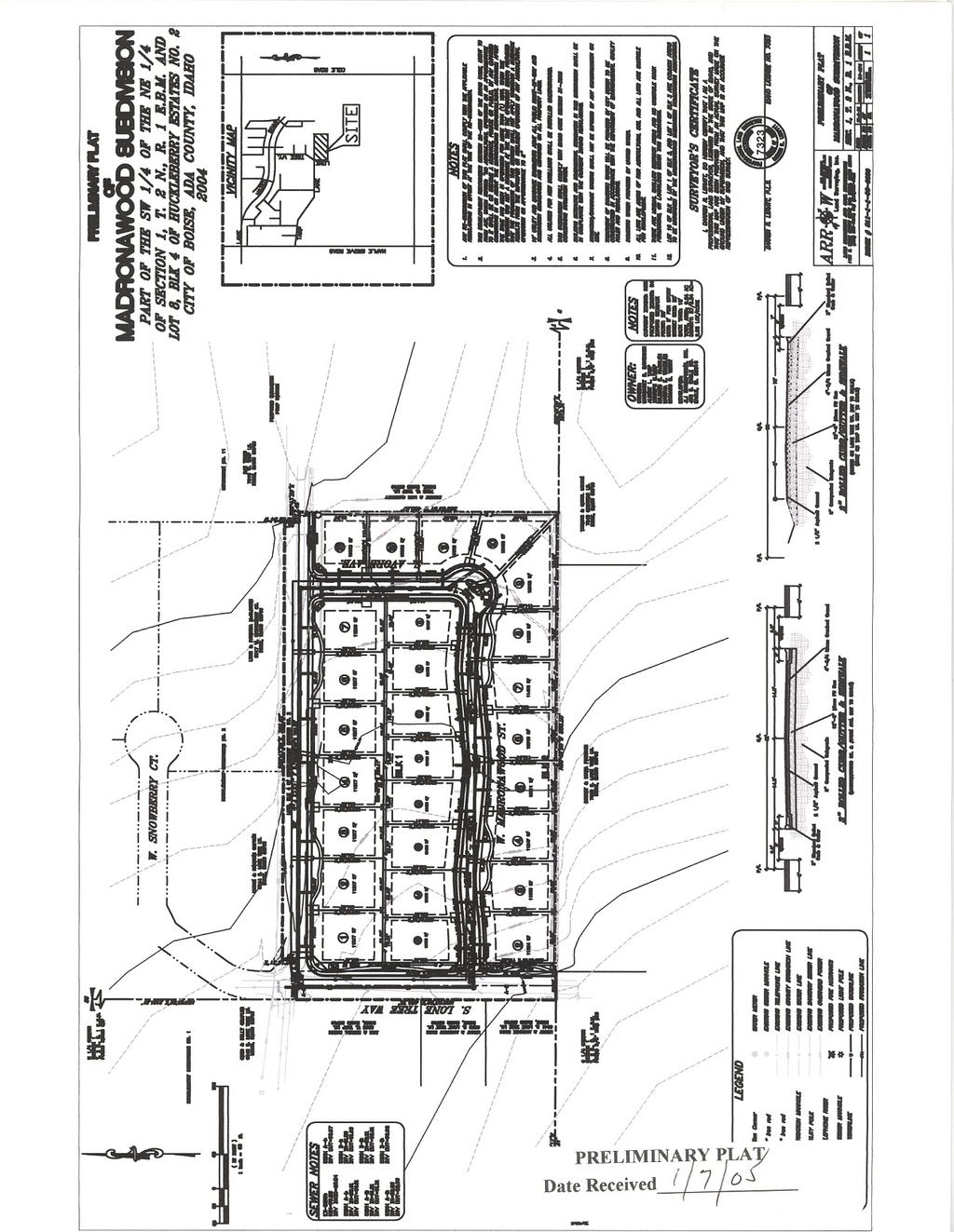
1 Subdivision Staff Report Name: Madronawood Subdivision Date: January 26, 2005 File: SUB Meeting: February 1, 2005 Approval: Preliminary To: City Council Lead Agency: Ada County (04-31-S) From: Richard Beck Comprehensive Plan: Complies Description: This is a proposed single family residential subdivision with 27 buildable lots and 3 common lots on 9.23 acres. The density of the subdivision is 2.93 lots per acre. The site is zoned RSW (County). Currently the subject parcel is vacant. There are companion County rezone and development agreement applications associated with this project. R4 zoning is proposed. Location: The site is located on the southeast corner of the intersection of South Lone Tree Way and West Tarp Lane, generally east of South Maple Grove Road and generally south of West Lake Hazel Road. Special Attention: Planning and Development Services Staff recommends denial of this subdivision. Contents: Staff Report: Basis for Denial Technical Review and Agency Comments Attachments: Vicinity map Preliminary plat Aerial photo Airport Influence Area map Fire Department Response Areas map
2 Page 2 of 23 Basis for Denial This application has been reviewed for consistency with the goals and policies of the Boise City Comprehensive Plan. The subject property is located in the Southwest planning area. The Land Use Map designation is Planned Community. The following Land Use Chapter policies have applicability to this application: Chapter 8, Land Use Goal Achieve a city that minimizes suburban sprawl, that provides for a diverse mixture of lifestyles and atmospheres and a sense of place that varies throughout the different areas of the City, and that efficiently provides basic services and facilities in close proximity to where people live. Objective 1) The land-use map and attendant policies shall be the official guide for development of the planning area and shall be implemented through zoning and development review. Policy 1) The Land Use/Zoning Consistency Matrix shall identify the zoning districts that are permissible within each land- use designation. Conformance with the Land Use/Zoning Consistency Matrix shall be a necessary finding of approval for all zone changes and conditional uses, unless one or more of the forms of flexibility identified in the policies under Objective 2 are implemented. Objective 8) The Planned Community land-use designation shall be used to create cohesive developments that contain a combination of land uses, which protect unique landforms and provide creative designs and built environments. Policy 1) Development under the Planned Community land-use designation shall require submittal of a conceptual master plan for approval by the Planning and Zoning Commission prior to submittal of first entitlement. Policy 2) The master plan for any Planned Community area must depict the general location and distribution of land-uses and public facilities, and must demonstrate compliance and consistency with all requirements of the Comprehensive Plan, including any site-specific requirements. Policy 3) Individual entitlement (i.e., Conditional Use, Plat Map) shall be allowed to more precisely define the location and design of development within the master plan, provided that the general intent of the master plan is adhered to. Page 2 of 23
3 Page 3 of 23 Policy 5) Existing City zoning districts, the alternative New Urbanism code, or specific plans may be used to implement the Planned Community land-use designation and master plan. Objective 13) Land-use and development policies specific to the Southwest shall include the following: Policy 4) Development in the Southwest Planned Community area shall include the following: An urban village shall be developed in the general vicinity of Lake Hazel and Five Mile. This shall include a commercial core of neighborhood-serving uses, including grocery and sundries, dining, medical and dental offices, day care, satellite government offices and similar uses. It shall be of a pedestrian oriented design, in accordance with the standards of New Urbanism. Mixed residential/commercial, townhouses and modular-lot residential uses shall be permitted in and around the urban village. Densities as high as 15 to 20 units per acre may be permitted in the urban village, but may drop to four units per gross acre as development moves out from the urban village core area. In the area east of Five Mile Road, a combination of residential products and densities shall be permitted, ranging from 1 to 25 units per acre. Additional neighborhood-serving commercial facilities may be permitted in this area. Overall developed densities in the Planned Community area may not exceed five to six units per gross acre. Equestrian and pedestrian trails shall be included as an integral part of the Planned Community area, and shall provide connections between the urban village, the golf course to the west and the regional park to the northeast. A master plan for development of the Planned Community area shall be prepared that demonstrates compliance with these principles, prior to first entitlement in the area. Incentives to achieve the New Urbanism designs shall be considered as part of the Master Plan and implementation ordinances. The entire Planned Community area in the Southwest need not be master planned in its entirety at one time, but any master plan must address a minimum of 100 acres. Smaller applications shall also adhere to the land use and design requirements of the Planned Community as identified in this policy, to the extent possible given their size and location. Policy 6) Throughout the Southwest area, particular attention shall be paid to new development to ensure compatibility with existing development including street system interconnections. Policy 7) Open fencing, transitional lot sizes and other design features shall be used to the greatest extent feasible to retain the rural atmosphere of the Southwest area. Page 3 of 23
4 Page 4 of 23 Policy8) Public parks and other open-space areas shall be encouraged for use as community farms and gardens to preserve the rural heritage of the Southwest. (See Recreation and Cultural Facilities chapter) Analysis of Compliance with Land Use Chapter Policies: Because this site is less than one hundred acres in size, a master plan is not required. The development does, however, still need to comply with the policies of the Planned Community area and the area specific policies of the Southwest planning area. In the Planned Community area the Land Use/Zoning Consistency Matrix identifies virtually all zones as having the potential of being acceptable. The appropriate zoning for specific areas needs to be determined by careful analysis of the site and the surrounding area. This subdivision is typical of the developments that are popular in the southwest, 10,000 square foot lots with no diversity of lot sizes. In the Planned Community area the intent of the Comprehensive Plan is to get creative design, with a variety of lot sizes and product types. By default, the area around this site in the far southwest has become an estate density area. All of the lots in Huckleberry Estates, which is located directly across the street from this development, both to the north and to the west, are a minimum of one acre. There is a specific policy regarding compatibility and transitional lot sizing for development in the southwest. The developer does not feel that this development should consider compatibility or transitional lotting with Huckleberry Estates since it is across the street from this development. Staff disagrees. The surrounding developments must be considered to ensure cohesive development. This development is not compatible with the surrounding area. Throughout the Southwest Planning area we have not been able to achieve the creative design and mix of lot sizes that was intended when the area was designated as a Planned Community. Staff sees this as a logical place to recapture some of that mix, with larger estate density lots. Half acre lots would blend nicely with the adjacent one acre lots. Staff intends higher density to be achieved in areas located closer to the urban village and other commercial areas. The following Transportation Chapter policies have applicability to this application: Chapter 6.1, Streets Goal Maintain the function of the street system for current users, emergency response efforts and for use by future generations. Page 4 of 23
5 Page 5 of 23 Objective 3) Encourage completion of the existing street system and creation of new links, within reasonable constraints, as the transportation system develops. Policy 5) New developments shall be required to stub access to adjacent undeveloped parcels, where appropriate. Policy 2) Allow full access to parcels abutting local streets, except where adequate alley access exists to individual lots, in which case new developments shall be encouraged to utilize the alley for access. Analysis of Compliance with Transportation Chapter Policies: This development is connecting to Tarp Land and Lone Tree Way. A street stub is not being provided to the properties to the south, even though one parcel is approximately five acres in size and the other is approximately 10 acres. Staff does not support this development, but if the County chooses to approve it then a street stub to the south is recommended. The following Community Quality Chapter policies have applicability to this application: Chapter 7.1, Housing Goal Provide an adequate supply of safe, sanitary housing at price and rent levels appropriate to the varied financial capabilities of City residents, and provide for a diversity in type, density and location of housing with special emphasis on maintaining neighborhood stability. Policy 1) Encourage a mix of housing types, densities and price ranges in residential developments. Chapter 7.2, Community Design Goal Create a community composed of neighborhoods in which services and amenities are convenient, visually pleasing and properly integrated and designed to encourage walking and cycling. Objective 2) Ensure through urban design the development of new residential structures that are functional and aesthetically pleasing. Policy 4) Require that residential street scenes provide variety and modulation in design and placement of homes. Page 5 of 23
6 Page 6 of 23 Objective 4) Reinforce the development of functional and visually appealing neighborhoods. Policy 1) In order to better connect neighborhoods, require that street configurations involve the interconnection of individual streets. Policy 4) Establish a continuous network of sidewalks, bicycle and/ or pedestrian paths to establish internal and external linkage within the community. Analysis of Compliance with Community Quality Chapter Policies: Because this development does not include a PUD staff is unable to review the design of the homes. The applicant has submitted a letter with this application indicating that the CC&R s for this development will require either side entry garages or garages that are set back from the house. Because these design guidelines have not been required in a development agreement and elevations and details have not been submitted, staff cannot consider this in the review of the development. Staff does, however, strongly encourage creative designs that discourage garage dominated homes and improve the street scene, as these features create a more walkable environment and improve the livability of the neighborhood. Summary of Comprehensive Plan Review Does project comply with Land Use Policies? No Does project comply with Pathway Policies? Yes Does project comply with Street Policies? Yes Staff Recommendation Denial of Rezone and Subdivision Plat Page 6 of 23
7 Page 7 of 23 Technical Review and Agency Comments Boise City Planning and Development Services: Subdivision Section Richard Beck No special comment. Comprehensive Planning and Zoning Section Angela Brosious (See Basis for Denial on page 2) Boise City Public Works: Engineering Rob Bousfield No comment. Pressure Irrigation - Kent Johnson Comply with Idaho Code, Section and/or Boise City Code Section K. Sewer - John Johnson Wet line sewers are required (B.C.C D.) Sewer easements required. Sewer assessment required. Street Lights - Henry Alarcon 6 street lights required. Boise City street light easement required. Boise City Fire Department - David Miller (no comments received) Boise City Parks Department - Cheyne Weston (no comments received) Boise Airport - John Anderson This project is located adjacent to Airport Influence Area A, with is affected by average sound levels in the DNL and/or aircraft traffic patterns below 1000 feet. New residential development and new schools are required to provide a sound level reduction of 25 DB. Although we have no regulatory authority over this area, neighbors in this are complain of over flights, which have historically been occurring for 60 years. We graciously request an avigation easement. Ada County Highway District Andrea Tuning (Staff draft report) B. Findings for Consideration 1. Tarp Lane History Tarp Lane was a private road that was created through a 25-foot easement that was held by the adjoining property owners. The private road did not meet the minimum standards for Ada County's private road requirements and served a number of Page 7 of 23
8 Page 8 of 23 illegal subdivisions. As a part of Huckleberry Estates Subdivision, Tarp Lane was required to be constructed as a public roadway with 27-feet of pavement and 3-foot gravel shoulders on both sides of the roadway. At the time that Tarp Lane became a public roadway, staff recommended that Tarp Lane be terminate at the intersection of Lone Tree Way due to the length of Tarp Lane (approximately 2,700- feet in length). Staff anticipated that the parcels to the east of Lone Tree Way could be served by Lake Hazel Road and/or other local roadways that had been provided by the adjoining Moonridge Subdivision. The Applicant s Proposal The applicant is proposing to extend Tarp Lane from the west property line to the east property line. Staff s Analysis and Recommendation As a part of the Huckleberry Estates Subdivision, staff recommended that Tarp Lane terminate at the intersection of Lone Tree Way due to the fact that the parcels to the east could be served by Lake Hazel Road and/or other local roadways that had been provided by the adjoining Moonridge Subdivision. At this time, this property does not have any pubic roadway access other than Tarp Lane. In order to provide this parcel with access to the pubic transportation system and be consistent with staff s previous findings of fact and recommendations, staff is recommending that the applicant be allowed to extend Tarp Lane from Lone Tree Way to the intersection of Avore Avenue. Staff is recommending that the remaining 90-feet of the proposed Tarp Lane (proposed as a stub street to the east property line) be removed from this plat. Staff is recommending that the stub street be relocated to the south as opposed to being constructed at the property s north property line. ***See Finding of Fact #5 on page #5 of this report. 2. Lone Tree Lane (proposed to be Lone Tree Way) History Lone Tree Lane is currently a private road at the west property line that currently serves 5-lots. Lone Tree Lane is private property that is owned by the developing property. The Applicant s Proposal The applicant is proposing to dedicate public right-of-way and construct a public road within the area that is currently Lone Tree Lane. Staff s Recommendation Staff is supportive of the applicant s proposal to dedicate and construct a public road within the area that is currently Lone Tree Lane due to the fact that the public roadway will continue to serve the 5-lots that it was previously serving, will provide the surrounding parcels with frontage and access to the public transportation system, and will provide this area with interconnectivity. 3. Roadway Offsets Page 8 of 23
9 Page 9 of 23 District policy , requires local roadways to align or offset a minimum of 125-feet from another local roadway (measured centerline to centerline). All of the internal roadways meet the minimum offsets that have been established by District policy. 4. Internal Street Sections West Madronawood Street and Avore Avenue District policy states that right-of-way widths for all streets and highways shall not be less than 50-feet wide except in unusual cases. Any request to the District to approve a street with a right-of-way width less than 50 must prove by clear convincing evidence that the facts and circumstances of the development warrant a finding of an exceptional case. The applicant must show that the roadway will be used for residential purposes, there will be no possibility that the street will be extended in the near future and the traffic volumes on the street are not forecast to exceed 200 vehicles per day. District policy allows a developer to construct a local urban residential street with a reduced width of 29-feet from back-of-curb to back-of-curb with curb, gutter and sidewalk. Policy restricts parking on reduced street sections. The applicant is proposing to construct West Madronawood Street and Avore Avenue as a 29-foot street section with vertical curb, gutter and 5-foot detached sidewalks within 42-feet of right-of-way. This street section meets District policy due to the fact that the roadways will carry residential traffic ONLY and are anticipated to carry less than 200 vehicle trips per day. The District requires the applicant to submit a letter from the appropriate fire district showing the review and approval of all reduced street sections. The District also restricts parking on one side of the roadway. The applicant should submit a signage plan restricting parking on one side of the roadway. Tarp Lane and Lone Tree Way District policy states if a proposed development abuts an unpaved street or streets the developer shall construct one-half of the full street improvements, including curb, gutter and concrete sidewalk plus additional pavement widening beyond the centerline established for the street to provide a minimum 24-feet wide paved surface. A 3-foot wide gravel shoulder and a drainage swale sized to accommodate the roadway storm runoff shall be constructed on the unimproved side. This street section shall be constructed within a minimum 40-foot right-ofway. Tarp Lane The applicant is proposing to construct Tarp Lane as 24-feet of pavement with rolled curb, gutter and sidewalk on the south side of the roadway with no gravel shoulder and a barrow ditch on the north side of the roadway. The District does Page 9 of 23
10 Page 10 of 23 allow for new developments to construct one half of the appropriate street section with a minimum of 24-feet of pavement when the roadway is placed on the property line and the adjacent property is anticipated to redevelop in the future and complete the roadway improvements. This situation is unique in the fact that the north side of Tarp Lane is developed and is not likely to redevelop in the future. Due to the fact that the north side of the newly proposed Tarp Lane is not likely to redevelop in the future, staff is unable to support the one-half of a street section simply based on the fact that the roadway will never be completed in the future. Staff discussed these concerns with the applicant on Wednesday January 19, 2005 and the applicant agreed to construct a full 29-foot street section with vertical curb and gutter on the north side of the proposed Tarp Lane with rolled curb (or vertical curb), gutter and sidewalk on the south side of Tarp Lane. Staff is willing to support the applicant s proposal and recommend a modification of policy to the Commission due to the fact that Tarp Lane is anticipated to serve a minimum amount of lots, Tarp Lane will be a completed street section and pedestrian and bicyclists will have a sidewalk to utilize on the south side of Tarp Lane. Lone Tree Way The applicant is proposing to construct Lone Tree Way as 24-feet of pavement with rolled curb, gutter and sidewalk on the east side of the roadway with no gravel shoulder and a barrow ditch on the west side of the roadway. The District does allow for new developments to construct one-half of the appropriate street section with a minimum of 24-feet of pavement when the roadway is placed on the property line and the adjacent property is anticipated to redevelop in the future and complete the roadway improvements. In this particular instance, the applicant is proposing to construct the roadway on the property line and it is safe to assume that the adjacent property will redevelop in the future and complete the roadway improvements. Due to the fact that the fact that the applicant meets the criteria to construct one-half of the appropriate street section with a minimum of 24-feet of pavement, the applicant should construct Lone Tree Way as one-half of a 36-foot street section with rolled curb, gutter and sidewalk on the east side of the roadway with a 3-foot gravel shoulder and an adequately sized barrow ditch on the west side of the roadway. 5. Stub Streets District policy states that the street design in a proposed development shall cause no undue hardship to adjoining property. An adequate and convenient access to adjoining property for use in future development may be required. If a street ends at the development boundary, it shall meet the requirements of sub section 7205, non-continuous streets. District policy states that stub streets will be required to provide intraneighborhood circulation or to provide access to adjoining properties. Stub streets will conform with the requirements described in Section , and Page 10 of 23
11 Page 11 of , except a temporary cul-de-sac will not be required if the stub street has a length no greater than 150-feet. A sign shall be installed at the terminus of the stub street stating that, "THIS ROAD WILL BE EXTENDED IN THE FUTURE". In addition, a stub street must meet the following conditions: 1. A stub street shall be designed to slope towards the street intersection and drain surface water toward that intersection; unless a satisfactory storm drain system is installed. 2. The District may require appropriate covenants guaranteeing that the stub street will remain free of obstructions. The applicant is proposing to construct a stub street to the east property line and the south property line. Stub Street to the East The applicant is proposing to construct Tarp Lane as a stub street to the east at the north property line. The stub street would serve the 5.0-acre site directly to the east. Due to the fact that staff previously recommended that Tarp Lane not extend to the east beyond Lone Tree Way (due to an extremely long roadway that is fairly straight in nature), staff is recommending that the applicant not construct Tarp Lane as the stub street to the east property. Staff recommends that the applicant relocate the stub street further to south. The applicant may extend Madronawood Street to the east property line or extend a new stub street to the east property line that is centrally located between Tarp Lane and Madronawood Street. By constructing a stub street in a location other than at the north property line, the District can eliminate an elongated roadway that is straight in nature while preserving connectivity within this area, the applicant does not lose a lot and is only required to do minor site modifications and the 5.0-acre parcel to the east will have a future roadway that is more conducive to redevelopment in the future. Due to the fact that the stub street will be less than 150-feet in depth, the applicant will not be required to provide a temporary turnaround at the terminus of the roadway, but the applicant will be required to install a sign at the terminus of the roadway that states, This road will be extended in the future. Stub Street to the South The applicant is proposing to extend Lone Tree Way as a stub street to the south property line. This stub street is anticipated to serve the 3.99-acre site to the south. Staff is supportive of the applicant s proposal. Due to the fact that the proposed stub street is less than 150-feet in depth, the applicant will not be required to provide a temporary turnaround at the terminus of the roadway but will be required to install a sign at the terminus of the roadway that states, This road will be extended in the future. 6. Knuckles District policy District policy and and the local Fire District standards require an island within a knuckle to be constructed with the island Page 11 of 23
12 Page 12 of 23 being a minimum of 4-feet wide with a minimum area of 100-square feet and designed to safely channel traffic. The roadway around the traffic island should maintain a minimum of a 29-foot street section. District policy also requires any proposed landscape islands/medians within the public right-of-way dedicated by this plat should be owned and maintained by a homeowners association. Notes of this should be required on the final plat. The design should be reviewed and approved by ACHD's Development staff. The applicant is proposing to construct a knuckle with an island within it in the southeast corner of Madronawood Street and Avore Avenue. Staff is supportive of the location of the proposed knuckle. The applicant should construct the island to be a minimum of 4-feet wide with a minimum area of 100-square feet. The applicant should also maintain a minimum street section of 29-feet on either side of the proposed island. All islands shall be owned and maintained by a homeowners association. Notes of this should be required on the final plat. The design should be reviewed and approved by ACHD's Development staff. C. Site Specific Conditions of Approval 1. Construct West Madronawood Street and Avore Avenue as a 29-foot street section with vertical curb, gutter and 5-foot detached concrete sidewalks within 42-feet of right-of-way as proposed. Submit a letter from the appropriate fire district showing the review and approval of all reduced street sections. Submit a signage plan restricting parking on one side of the roadway. 2. Construct Tarp Lane as a full 29-foot street section with vertical curb and gutter on the north side of the roadway and rolled curb, gutter and sidewalk on the south side of Tarp Lane within the proposed 50-feet of right-of-way, as proposed. 3. Construct Lone Tree Way as one-half of a 36-foot street section with rolled curb, gutter and sidewalk on the east side of the roadway with a minimum of 24-feet of pavement with a 3-foot gravel shoulder and an adequately sized barrow ditch on the west side of the roadway. 4. Relocate the Tarp Lane stub street further to south. Extend Madronawood Street to the east property line or extend a new stub street to the east property line that is centrally located between Tarp Lane and Madronawood Street. Install a sign at the terminus of the roadway that states, This road will be extended in the future. 5. Extend Lone Tree Way as a stub street to the south property line, as proposed. Install a sign at the terminus of the roadway that states, This road will be extended in the future. Page 12 of 23
13 Page 13 of Construct a knuckle with an island within it in the southeast corner of Madronawood Street and Avore Avenue, as proposed. Construct the island to be a minimum of 4-feet wide with a minimum area of 100-square feet. Maintain a minimum street section of 29-feet on either side of the proposed island. All islands shall be owned and maintained by a homeowners association. Notes of this shall be required on the final plat. The design shall be reviewed and approved by ACHD's Development staff. 7. Comply with all Standard Conditions of Approval. Page 13 of 23
14 Page 14 of 23 Recommendation The City of Boise recommends Ada County deny approval of Madronawood Subdivision based upon the following: This application has been reviewed for consistency with the goals and policies of the Boise City Comprehensive Plan. The subject property is located in the Southwest planning area. The Land Use Map designation is Planned Community. The following Land Use Chapter policies have applicability to this application: Chapter 8, Land Use Goal Achieve a city that minimizes suburban sprawl, that provides for a diverse mixture of lifestyles and atmospheres and a sense of place that varies throughout the different areas of the City, and that efficiently provides basic services and facilities in close proximity to where people live. Objective 1) The land-use map and attendant policies shall be the official guide for development of the planning area and shall be implemented through zoning and development review. Policy 1) The Land Use/Zoning Consistency Matrix shall identify the zoning districts that are permissible within each land- use designation. Conformance with the Land Use/Zoning Consistency Matrix shall be a necessary finding of approval for all zone changes and conditional uses, unless one or more of the forms of flexibility identified in the policies under Objective 2 are implemented. Objective 8) The Planned Community land-use designation shall be used to create cohesive developments that contain a combination of land uses, which protect unique landforms and provide creative designs and built environments. Policy 1) Development under the Planned Community land-use designation shall require submittal of a conceptual master plan for approval by the Planning and Zoning Commission prior to submittal of first entitlement. Policy 2) The master plan for any Planned Community area must depict the general location and distribution of land-uses and public facilities, and must demonstrate compliance and consistency with all requirements of the Comprehensive Plan, including any site-specific requirements. Page 14 of 23
15 Page 15 of 23 Policy 3) Individual entitlement (i.e., Conditional Use, Plat Map) shall be allowed to more precisely define the location and design of development within the master plan, provided that the general intent of the master plan is adhered to. Policy 5) Existing City zoning districts, the alternative New Urbanism code, or specific plans may be used to implement the Planned Community land-use designation and master plan. Objective 13) Land-use and development policies specific to the Southwest shall include the following: Policy 4) Development in the Southwest Planned Community area shall include the following: An urban village shall be developed in the general vicinity of Lake Hazel and Five Mile. This shall include a commercial core of neighborhood-serving uses, including grocery and sundries, dining, medical and dental offices, day care, satellite government offices and similar uses. It shall be of a pedestrian oriented design, in accordance with the standards of New Urbanism. Mixed residential/commercial, townhouses and modular-lot residential uses shall be permitted in and around the urban village. Densities as high as 15 to 20 units per acre may be permitted in the urban village, but may drop to four units per gross acre as development moves out from the urban village core area. In the area east of Five Mile Road, a combination of residential products and densities shall be permitted, ranging from 1 to 25 units per acre. Additional neighborhood-serving commercial facilities may be permitted in this area. Overall developed densities in the Planned Community area may not exceed five to six units per gross acre. Equestrian and pedestrian trails shall be included as an integral part of the Planned Community area, and shall provide connections between the urban village, the golf course to the west and the regional park to the northeast. A master plan for development of the Planned Community area shall be prepared that demonstrates compliance with these principles, prior to first entitlement in the area. Incentives to achieve the New Urbanism designs shall be considered as part of the Master Plan and implementation ordinances. The entire Planned Community area in the Southwest need not be master planned in its entirety at one time, but any master plan must address a minimum of 100 acres. Smaller applications shall also adhere to the land use and design requirements of the Planned Community as identified in this policy, to the extent possible given their size and location. Policy 6) Throughout the Southwest area, particular attention shall be paid to new development to ensure compatibility with existing development including street system interconnections. Page 15 of 23
16 Page 16 of 23 Policy 7) Open fencing, transitional lot sizes and other design features shall be used to the greatest extent feasible to retain the rural atmosphere of the Southwest area. Policy8) Public parks and other open-space areas shall be encouraged for use as community farms and gardens to preserve the rural heritage of the Southwest. (See Recreation and Cultural Facilities chapter) Analysis of Compliance with Land Use Chapter Policies: Because this site is less than one hundred acres in size, a master plan is not required. The development does, however, still need to comply with the policies of the Planned Community area and the area specific policies of the Southwest planning area. In the Planned Community area the Land Use/Zoning Consistency Matrix identifies virtually all zones as having the potential of being acceptable. The appropriate zoning for specific areas needs to be determined by careful analysis of the site and the surrounding area. This subdivision is typical of the developments that are popular in the southwest, 10,000 square foot lots with no diversity of lot sizes. In the Planned Community area the intent of the Comprehensive Plan is to get creative design, with a variety of lot sizes and product types. By default, the area around this site in the far southwest has become an estate density area. All of the lots in Huckleberry Estates, which is located directly across the street from this development, both to the north and to the west, are a minimum of one acre. There is a specific policy regarding compatibility and transitional lot sizing for development in the southwest. The developer does not feel that this development should consider compatibility or transitional lotting with Huckleberry Estates since it is across the street from this development. The City of Boise disagrees. The surrounding developments must be considered to ensure cohesive development. This development is not compatible with the surrounding area. Throughout the Southwest Planning area we have not been able to achieve the creative design and mix of lot sizes that was intended when the area was designated as a Planned Community. The City of Boise sees this as a logical place to recapture some of that mix, with larger estate density lots. Half acre lots would blend nicely with the adjacent one acre lots. The City of Boise intends higher density to be achieved in areas located closer to the urban village and other commercial areas. The following Transportation Chapter policies have applicability to this application: Chapter 6.1, Streets Goal Page 16 of 23
17 Page 17 of 23 Maintain the function of the street system for current users, emergency response efforts and for use by future generations. Objective 3) Encourage completion of the existing street system and creation of new links, within reasonable constraints, as the transportation system develops. Policy 5) New developments shall be required to stub access to adjacent undeveloped parcels, where appropriate. Policy 2) Allow full access to parcels abutting local streets, except where adequate alley access exists to individual lots, in which case new developments shall be encouraged to utilize the alley for access. Analysis of Compliance with Transportation Chapter Policies: This development is connecting to Tarp Land and Lone Tree Way. A street stub is not being provided to the properties to the south, even though one parcel is approximately five acres in size and the other is approximately 10 acres. The City of Boise does not support this development, but if the County chooses to approve it then a street stub to the south is recommended. The following Community Quality Chapter policies have applicability to this application: Chapter 7.1, Housing Goal Provide an adequate supply of safe, sanitary housing at price and rent levels appropriate to the varied financial capabilities of City residents, and provide for a diversity in type, density and location of housing with special emphasis on maintaining neighborhood stability. Policy 1) Encourage a mix of housing types, densities and price ranges in residential developments. Chapter 7.2, Community Design Goal Create a community composed of neighborhoods in which services and amenities are convenient, visually pleasing and properly integrated and designed to encourage walking and cycling. Objective 2) Ensure through urban design the development of new residential structures that are functional and aesthetically pleasing. Page 17 of 23
18 Page 18 of 23 Policy 4) Require that residential street scenes provide variety and modulation in design and placement of homes. Objective 4) Reinforce the development of functional and visually appealing neighborhoods. Policy 1) In order to better connect neighborhoods, require that street configurations involve the interconnection of individual streets. Policy 4) Establish a continuous network of sidewalks, bicycle and/ or pedestrian paths to establish internal and external linkage within the community. Analysis of Compliance with Community Quality Chapter Policies: Because this development does not include a PUD The City of Boise is unable to review the design of the homes. The applicant has submitted a letter with this application indicating that the CC&R s for this development will require either side entry garages or garages that are set back from the house. Because these design guidelines have not been required in a development agreement and elevations and details have not been submitted, The City of Boise cannot consider this in the review of the development. The City of Boise does, however, strongly encourage creative designs that discourage garage dominated homes and improve the street scene, as these features create a more walkable environment and improve the livability of the neighborhood. Summary of Comprehensive Plan Review Does project comply with Land Use Policies? No Does project comply with Pathway Policies? Yes Does project comply with Street Policies? Yes Recommended Conditions of Approval Should Ada County decide to approve Madronawood Subdivision, the following are the Recommended Conditions of the City of Boise. Recommendations to Ada County A) It is recommended that Ada County require the applicant to stub Avore Avenue to the south property line. Special Conditions Page 18 of 23
19 Page 19 of 23 1) Submit a recorded copy of an Avigation Easement over the entire platted area approved by the Boise City Airport Director. The face of the final plat shall show that the subdivision is subject to an avigation easement or easements. a) This project is located adjacent to Airport Influence Area A, with is affected by average sound levels in the DNL and/or aircraft traffic patterns below feet. New residential development and new schools are required to provide a sound level reduction of 25 DB. Covenant Requirements 2) Covenants, homeowners association by-laws or other similar deed restrictions acceptable to the Boise City Attorney, which provide for the use, control and maintenance of all common areas, storage facilities, recreational facilities or open spaces shall be reviewed and approved by the Boise City Attorney. Irrigation Conditions 3) Comply with Boise City Code Section K concerning pressure irrigation requirements prior to signing of the final plat by the Boise City Engineer. a) The owner or person, firm or corporation filing the subdivision plat shall provide a pressurized irrigation system. The system must conform to the minimum design standards and specifications of Boise City or of the entity that will operate and maintain the system, if that entity has published standards. Fees: Developer and/or owner shall pay the current inspection and plan review fees on the proposed subdivision prior to signing of the final plat by the Boise City Engineer (B.C.C A.2). b) Developer may construct prior to final platting or bond in the amount of 110% of the estimated construction costs. c) Prior to either commencing construction or signing of the final plat by the Boise City Engineer, developer shall: i) Submit construction plans and specifications for the pressurized system, stamped by a registered engineer, to the Department of Public Works and acquire approval there from. ii) Provide written assurance that provisions have been made for ownership, operation, and maintenance of the system. Page 19 of 23
20 Page 20 of 23 iii) Delineate all necessary irrigation easements on the final plat (B.C.C F). d) Developer shall provide for an independent inspection of the installation of irrigation facilities and written certification by the design or project engineer that the system was installed according to the approved plans. In addition, the Department of Public Works must be present for the system pressure test and participate in a final inspection. Sewer Conditions 4) The developer and/or owner shall delineate all necessary Boise City sanitary sewer easements on the final plat prior to signing of the final plat by the Boise City Engineer (B.C.C F). 5) Wet line sewers are required (B.C.C D). a) Developer/owner shall contact the Public Works Department regarding the financing and details of extending the sewers to the subject property. Developer shall enter into a sewer reimbursement contract with the City of Boise. b) Plans shall be submitted to and approved by the Boise City Public Works Department and the Idaho Division of Environmental Quality prior to commencing with construction. Developer/owner may either construct improvements prior to final platting or execute a performance agreement and provide surety in the amount of 110% of the estimated costs. The developer shall coordinate with the Public Works Department for construction inspection prior to and during construction. Unless otherwise approved by the Public Works Department, all sewer construction shall be completed and accepted within 90 days of plat recordation or within 30 days of issuance of the first building permit within the subdivision, whichever comes first. NOTE: All bonding shall conform to Boise City Code, Title 8, Chapter 20. c) Developer/owner shall pay the current sewer inspection fees for the proposed subdivision prior to signing of the final plat by the Boise City Engineer. d) All lots within this subdivision shall be subject to and restricted by the following recorded subdivision covenants: Page 20 of 23
21 Page 21 of 23 i) A monthly sewer charge must be paid after connecting to the Boise City public sewer system, according to the ordinances and laws of Boise City. ii) Owner shall submit to inspection by either the Public Works Department or the Building Department whenever a subdivided lot is to be connected to the City's sewage system and a building is constructed or installed on or within the owner's property. iii) iv) The developer/owner of this subdivision or lot or lots therein shall and hereby does vest in Boise City the right and power to bring all actions against the owner of the premises hereby conveyed or any part thereof for the collection of any charges herein required and to enforce the conditions herein stated. This covenant shall run with the land. The recording of this plat by developer/owner shall be deemed and construed as a request for annexation of its property to the corporate limits of Boise City. Such request and consent shall be binding on all subsequent purchasers or owners of developer's property. v) Covenants to be approved by the Boise City Attorney. 6) Developer and/or owner shall construct sewer or pay a sewer assessment along Tarp Lane and Lone Tree Way and/or as may be approved by the Boise City Public Works Commission prior to signing of the final plat by the Boise City Engineer. Contact the Department of Public Works for specific costs. Street Light Conditions 7) Developer shall delineate on the face of the final plat a Boise City street light easement, acceptable to the Boise City Department of Public Works, for the purpose of installing and maintaining city-owned street light fixtures, conduit and wiring lying outside the dedicated public right-of-way (B.C.C F). 8) The developer shall be required to install, at their expense, street lights in accordance with Boise City Public Works specifications and standards at locations designated by the Public Works Department (B.C.C H.1). Plans shall be reviewed and approved by the Boise City Public Works Department prior to commencement of construction, bonding, or payment into trust fund. a) Fees: Developer shall pay the current street light inspection and plan review fees on the proposed subdivision (B.C.C A.2). Page 21 of 23
22 Page 22 of 23 b) The street lights shall be installed and accepted by the Boise City Public Works Department at the following locations. Unless otherwise noted, street lights shall be installed at a 25-foot minimum mounting height, 100 W.H.P.S. (1) N.W. Corner Lot 1, Block 1 (2) N.E. Corner Lot 4, Block 1 (3) N.W. Corner Lot 13, Block 2 (4) S.E. Corner Lot 8, Block 1 (5) N.E. Corner Lot 5, Block 2 (6) S.E. Corner Lot 15, Block 1 c) If bonding approval is granted by the Boise City Public Works Department, developer may bond in the amount of 110% of the estimated street light costs. Street lights shall be installed within 90 days of the issuance of the first building permit in the development, if building permits are obtained prior to completion of street light improvements. General Conditions 9) The developer shall make arrangements to comply with all requirements of the Boise City Fire Department and verify in one of the following ways: a) A letter from the Boise City Fire Department stating that all conditions for water, access, and/or other requirements have been satisfied, OR b) A non-build agreement has been executed and recorded with a note on the face of the final plat identifying the instrument number. NOTE: i) For streets having a width less than 36 feet back of curb to back of curb parking shall be restricted on (1) one side; for streets having a width less than 29 feet back of curb to back of curb parking shall be restricted on both sides; and for standard ACHD cul-de-sacs parking shall be restricted on both sides. A note on the face of the final plat is required noting the parking restriction prior to signing of the final plat by the Boise City Engineer. ii) "No Parking" signs and curb painting shall be required on streets having a width less than 36-feet, back of curb to back of curb. Contact the Boise City Fire Department for sign placement and spacing. Developer may either construct prior to final platting or post bond in the amount of 110% of the estimated costs with the Boise City Planning and Development Services Department. Page 22 of 23
23 Page 23 of 23 10) Prior to submitting the final plat for recording, the following endorsement or certification must be executed: Certificate of the City Engineer stating, I, the undersigned Boise City Engineer, hereby state that the recommended conditions of Boise City have been satisfied for Madronawood Subdivision. (I.C. Title 50, Chapter 13). Page 23 of 23
24
25
26


27 Legend Aerial Photo This map is a user generated static output from an Internet mapping site and is for general reference only. Data layers that appear on this map may or may not be accurate, current, or otherwise reliable. THIS MAP IS NOT TO BE USED FOR NAVIGATION. Use and distribution of this map subject to copyright and disclaimer notices at Map Center: , Scale: 1:3,737
28 ASH PARK COLE INTERSTATE 84 VICTORY LAKE HAZEL CLOVERDALE OVERLAND AMITY LA GRANGE COLUMBIA FIVE MILE MAPLE GROVE DESERT UMATILLA TARGEE GOWEN CURTIS ORCHARD ROOSEVELT Boise Municipal Airport PLEASANT VALLEY VISTA FEDERAL GOWEN PRODUCTION BROADWAY Airport Influence Areas HUBBARD A B B-1 C Roads Boise City Comprehensive Plan Environmental Quality Chapter Three Goal Three TENMILE CREEK a. All new residential development and new schools in Airport Influence Area A, which are affected by average sound levels in the DNL and/or aircraft traffic patterns below 1,000 feet, shall be required to provide a sound level reduction of 25 db. b. All development within Airport Influence Area B is affected by average sound levels in the DNL and/or aircraft traffic patterns below 1,000 feet. Residential development is not allowed. All compatible uses will be required to provide sound insulation in noise sensitive areas of a facility. c. All development within Airport Influence Area B-1 is affected by average sound levels in the DNL and/or aircraft traffic patterns below 1,000 feet. New residential development shall be required to provide a sound level reduction of 30 db. For new residential development, the maximum density is three residential units per acre. No new schools are allowed. Office and commercial use are compatible. All compatible uses shall be required to provide sound insulation in noise sensitive areas of a facility. d. All development within Airport Influence Area C is affected by average sound levels greater than 70 DNL. The approved Airport Noise Compatibility Plan identifies existing residential uses in this area to undergo sound insulation. Residential uses in this area shall be considered non-conforming and no new residential development is allowed. Non-noise sensitive manufacturing, industrial and commercial uses are allowed. All compatible uses shall be required to provide sound insulation in noise sensitive areas of a facility.
29
Subdivision Staff Report
 Subdivision Staff Report Name: Brownstone Subdivision Date: May 12, 2004 File: SUB04-00041 Meeting: May 18, 2004 Approval: Preliminary To: City Council Lead Agency: Ada County (04-10-S) From: Richard Beck
Time Extension Staff Report
 Time Extension Staff Report Subdivision Name Lunara Subdivision File Number SUB07-00019 Approval Time Extension for Lead Agency Boise City Certification Signature of Boise City Engineer Annexation Date
Subdivision Staff Report
 Subdivision Staff Report Subdivision Name Sunnyridge Subdivision File Number SUB07-00007 Approval Preliminary Plat Lead Agency Ada County Annexation Date NA Comp. Plan Complies (With Conditions of Approval)
Amended Subdivision Staff Report
 Amended Subdivision Staff Report Subdivision Name Silverpine Subdivision File Number SUB06-00052 No.2 Approval Preliminary Plat Lead Agency Ada County Annexation Date NA Comp. Plan Complies (With Conditions
Subdivision Staff Report
 Subdivision Staff Report Subdivision Name Madera Creek File Number SUB06-00068 Subdivision Approval Final Plat Lead Agency Boise City Annexation Date December 9, 1974 Comp. Plan Complies Public Hearing
Time Extension Staff Report
 Time Extension Staff Report Subdivision Name Therrin Subdivision File Number SUB06-00020 Approval Time Extension for Lead Agency Boise City Certification Signature of Boise City Engineer Annexation Date
Subdivision Staff Report
 Subdivision Staff Report Subdivision Name Coldstream File Number SUB06-00040 Subdivision Approval Preliminary Plat Lead Agency Boise City Annexation Date December 9, 1974 Comp. Plan Complies Public Hearing
Subdivision Staff Report
 Subdivision Staff Report Subdivision Name Toli Park Subdivision File Number SUB07-00035 Approval Preliminary Plat Lead Agency Boise City Annexation Date December 30, 1987 Comp. Plan Complies Public Hearing
Subdivision Staff Report
 Subdivision Staff Report Subdivision Name Birmingham Place File Number SUB06-00051 Subdivision Approval Preliminary/Final Plat Lead Agency Boise City Annexation Date December 3, 1962 Comp. Plan Complies
Subdivision Staff Report
 Subdivision Staff Report Subdivision Name Honeymoon Cove Subdivision File Number SUB08-00005 Approval Preliminary/ Final Plat Lead Agency Boise City Annexation Date December 30, 2004 Comp. Plan Complies
Committed to Service
 Committed to Service Paul Woods, President Rebecca W. Arnold, Vice President Sara M. Baker, Commissioner Jim D. Hansen, Commissioner Kent Goldthorpe, Commissioner August 25, 2017 Development Services TO:
ARTICLE 15 - PLANNED UNIT DEVELOPMENT
 Section 15.1 - Intent. ARTICLE 15 - PLANNED UNIT DEVELOPMENT A PUD, or Planned Unit Development, is not a District per se, but rather a set of standards that may be applied to a development type. The Planned
SECTION 7000 LAND DEVELOPMENT REQUIREMENTS
 SECTION 7000 LAND DEVELOPMENT REQUIREMENTS 7000 LAND DEVELOPMENT REQUIREMENTS... 1 7001 LEGISLATIVE AUTHORITY... 1 7001.1 LAND DEVELOPMENT... 1 7001.1.1 Title 40, Idaho Code... 1 7001.1.2 Idaho Code 40-1415
a. provide for the continuation of collector streets and thoroughfare streets between adjacent subdivisions;
 Section 7.07. Intent The requirements of this Section are intended to provide for the orderly growth of the Town of Holly Springs and its extra-territorial jurisdiction by establishing guidelines for:
SUBDIVISION DESIGN PRINCIPLES AND STANDARDS
 SECTION 15-200 SUBDIVISION DESIGN PRINCIPLES AND STANDARDS 15-201 STREET DESIGN PRINCIPLES 15-201.01 Streets shall generally conform to the collector and major street plan adopted by the Planning Commission
#1 (CAR /SUB )
") Development Services Department Project/File: Lead Agency: Site address: Fork South #1 (CAR14-00009/SUB14-00024) The applicant is requesting annexation, rezone and preliminary plat approvals for a 52-lot
Development Services Department Project/File: Lead Agency: Site address: Fork South #1 (CAR14-00009/SUB14-00024) The applicant is requesting annexation, rezone and preliminary plat approvals for a 52-lot
ARTICLE 24 PRIVATE ROAD, SHARED PRIVATE DRIVEWAY AND ACCESS EASEMENT STANDARDS
 ARTICLE 24 PRIVATE ROAD, SHARED PRIVATE DRIVEWAY AND ACCESS EASEMENT STANDARDS SECTION 24.00 INTENT AND PURPOSE The standards of this Article provide for the design, construction and maintenance of private
Section Preliminary Plat Checklist and Application Forms
 Section 201 - Preliminary Plat Checklist and Application Forms PRELIMINARY SUBDIVISION PLAT REVIEW PROCESS CHART PRELIMINARY SUBDIVISION PLAT APPLICATION PRELIMINARY PLAT REVIEW CHECKLIST CITY OF NAMPA
Committed to Service
 Committed to Service Sara M. Baker, President Rebecca W. Arnold, Vice President Jim D. Hansen, Commissioner Kent Goldthorpe, Commissioner Paul Woods, Commissioner January 16, 2018 Development Services
DAUPHIN CREEK ESTATES SUBDIVISION
 # 12 SUB-000076-2017 DAUPHIN CREEK ESTATES SUBDIVISION Engineering Comments: FINAL PLAT COMMENTS (should be addressed prior to submitting the FINAL PLAT for review and/or signature by the City Engineer):
Committed to Service
 Committed to Service Kent Goldthorpe, President Paul Woods, Vice President Rebecca W. Arnold, Commissioner Sara M. Baker, Commissioner Jim D. Hansen, Commissioner July 18, 2016 Development Services TO:
May 21, ACHD Board of Commissioners Stacey Yarrington, Planner II DRH /DRH
 Development Services Department May 21, 2013 TO: FROM: SUBJECT: ACHD Board of Commissioners Stacey Yarrington, Planner II DRH13-00106/DRH13-00108 Executive Summary: This is a design review application
PLANNED UNIT DEVELOPMENT & SUBDIVISION STAFF REPORT Date: April 18, 2019
 PLANNED UNIT DEVELOPMENT & SUBDIVISION STAFF REPORT Date: April 18, 2019 DEVELOPMENT NAME SUBDIVISION NAME Springhill Village Subdivision Springhill Village Subdivision LOCATION 4350, 4354, 4356, 4358,
Date: March 16, Jake Centers ERD, LLC P.O. Box 1610 Eagle, ID Elevation Ridge Subdivision (SUB & PUD ) Street Address
 Street Address") Rebecca W. Arnold, President Sara M. Baker, Vice President John S. Franden, Commissioner Carol A. McKee, Commissioner David L. Case, Commissioner Date: March 16, 2012 To: Jake Centers ERD, LLC P.O. Box
Rebecca W. Arnold, President Sara M. Baker, Vice President John S. Franden, Commissioner Carol A. McKee, Commissioner David L. Case, Commissioner Date: March 16, 2012 To: Jake Centers ERD, LLC P.O. Box
If you have any questions, please feel free to contact me at (208)
") Sara M. Baker, President John S. Franden, Vice President Rebecca W. Arnold, Commissioner Mitchell A. Jaurena, Commissioner Jim Hansen, Commissioner Date: March 21, 2013 To: Subject: Hornet Construction
Sara M. Baker, President John S. Franden, Vice President Rebecca W. Arnold, Commissioner Mitchell A. Jaurena, Commissioner Jim Hansen, Commissioner Date: March 21, 2013 To: Subject: Hornet Construction
STAFF REPORT Administrative Subdivision Hearing West 150 South Street, Parcel # , and
 Petition Number: 490-06-24 STAFF REPORT Administrative Subdivision Hearing Project Name: Project Location: Project Type: Applicant: Planning Staff: Haight Industrial Subdivision 5550 West 150 South Street,
Executive Summary: This is a preliminary plat to construct 8 residential lots and 2 commons lots with a private road on 3.87-acres in Meridian, Idaho.
 Development Services Department DATE: July 7, 2015 TO: FROM: SUBJECT: ACHD Board of Commissioners Stacey Yarrington, Planner III Kentucky Villas/ MPP15-0012/ PP15-009 Executive Summary: This is a preliminary
SUB /CAR /PUD
 Development Services Department Project/File: Lead Agency: Site address: Balntyre Court Subdivision/BPP16-0036/ SUB16-00066/CAR16-00035/PUD16-00040 This is a rezone, planned unit development, and subdivision
Draft Zoning Changes for the 2nd Planning Board Public Hearing, January 22, 2018.
 Draft Zoning Changes for the 2nd Planning Board Public Hearing, January 22, 2018. No changes were made at the 1st Public Hearing. Proposed wording for the 1 st Public Hearing in red, eliminated text in
ARTICLE VI. SUBDIVISION STANDARDS, PUBLIC
 ARTICLE VI. SUBDIVISION STANDARDS, PUBLIC IMPROVEMENTS, AND DESIGN REQUIREMENTS ARTICLE VI. SUBDIVISION STANDARDS, PUBLIC IMPROVEMENTS, AND DESIGN REQUIREMENTS DIVISION 1. GENERAL PROVISIONS Sec. 21-6100.
Let me know if I need to bring you any other documentation for this withdrawl. Thanks!
 >>> david benoit 11/27/2007 10:00 AM >>> Dave, I am set to be heard on the Cranston Corner Subdivision on December 4th in front of City council. I have sold this property and am requesting
The following information is for use by the Lincoln County Planning Board at their meeting/public hearing on February 3, 2014.
 LINCOLN COUNTY PLANNING & INSPECTIONS DEPARTMENT 302 NORTH ACADEMY STREET, SUITE A, LINCOLNTON, NORTH CAROLINA 28092 704-736-8440 OFFICE 704-736-8434 INSPECTION REQUEST LINE 704-732-9010 FAX To: Planning
PLANNED UNIT DEVELOPMENT & SUBDIVISION STAFF REPORT Date: November 17, 2016
 PLANNED UNIT DEVELOPMENT & SUBDIVISION STAFF REPORT Date: November 17, 2016 DEVELOPMENT NAME SUBDIVISION NAME LOCATION Autonation Ford of Mobile Autonation Ford of Mobile Subdivision 901, 909, and 925
The following regulations shall apply in the R-E District:
 "R-E" RESIDENTIAL ESTATE DISTRICT (8/06) The following regulations shall apply in the R-E District: 1. Uses Permitted: The following uses are permitted. A Zoning Certificate may be required as provided
Chapter Plat Design (LMC)
") Chapter 18.14 Plat Design (LMC) Sections: 18.14.010 Lot width 18.14.020 Right-of-way requirements 18.14.030 Pipe stem lots 18.14.040 Division resulting in minimum lot sizes 18.14.050 Flood prone and bad
Chapter 18.14 Plat Design (LMC) Sections: 18.14.010 Lot width 18.14.020 Right-of-way requirements 18.14.030 Pipe stem lots 18.14.040 Division resulting in minimum lot sizes 18.14.050 Flood prone and bad
ARTICLE 3: Zone Districts
 ARTICLE 3: Zone Districts... 3-1 17.3.1: General...3-1 17.3.1.1: Purpose and Intent... 3-1 17.3.2: Districts and Maps...3-1 17.3.2.1: Applicability... 3-1 17.3.2.2: Creation of Districts... 3-1 17.3.2.3:
PLANNED UNIT DEVELOPMENTS (Ordinance No.: 3036, 12/3/07; Repealed & Replaced by Ordinance No.: 4166, 10/15/12)
") 159.62 PLANNED UNIT DEVELOPMENTS (Ordinance No.: 3036, 12/3/07; Repealed & Replaced by Ordinance No.: 4166, 10/15/12) A. PURPOSE 1. General. The Planned Unit Development (PUD) approach provides the flexibility
159.62 PLANNED UNIT DEVELOPMENTS (Ordinance No.: 3036, 12/3/07; Repealed & Replaced by Ordinance No.: 4166, 10/15/12) A. PURPOSE 1. General. The Planned Unit Development (PUD) approach provides the flexibility
610 LAND DIVISIONS AND PROPERTY LINE ADJUSTMENTS OUTSIDE A UGB
 ARTICLE VI: LAND DIVISIONS AND PROPERTY LINE ADJUSTMENTS VI-21 610 LAND DIVISIONS AND PROPERTY LINE ADJUSTMENTS OUTSIDE A UGB 610-1 Property Line Adjustments (Property Line Relocation) A property line
PLANNED DEVELOPMENT DISTRICT STANDARDS. Cadence Site
 PLANNED DEVELOPMENT DISTRICT STANDARDS Cadence Site A Planned Development District 1. Statement of General Facts, Conditions and Objectives Property Size: Approximately 57.51 Acres York County Tax Map
Staff Report: Date: Applicant: Property Identification: Acreage of Request: Current Zoning of Requested Area: Requested Action: Attached:
 Staff Report: Completed by Jeff Palmer Director of Planning & Zoning Date: November 7, 2018, Updated November 20, 2018 Applicant: Greg Smith, Oberer Land Developer agent for Ronald Montgomery ET AL Property
Location: The subject property is located at the northeast corner of S. Holden Lane and E. Boise Avenue.
 Subdivision Staff Report Subdivision Name Tianna Park File Number SUB11-00008 Approval Preliminary Plat Lead Agency Boise City Annexation Date December 19, 1977 Comp. Plan Complies Public Meeting Date
ARTICLE 14 PLANNED UNIT DEVELOPMENT (PUD) DISTRICT
 DISTRICT") ARTICLE 14 PLANNED UNIT DEVELOPMENT (PUD) DISTRICT Section 14.01 Intent. It is the intent of this Article to allow the use of the planned unit development (PUD) process, as authorized by the Michigan Zoning
ARTICLE 14 PLANNED UNIT DEVELOPMENT (PUD) DISTRICT Section 14.01 Intent. It is the intent of this Article to allow the use of the planned unit development (PUD) process, as authorized by the Michigan Zoning
PLANNED UNIT DEVELOPMENT & SUBDIVISION STAFF REPORT August 18, 2016
 PLANNED UNIT DEVELOPMENT & SUBDIVISION STAFF REPORT August 18, 2016 DEVELOPMENT NAME SUBDIVISION NAME Mullinax Ford Subdivision Mullinax Ford Subdivision LOCATION CITY COUNCIL DISTRICT District 6 Southeast
ARTICLE IV: DEVELOPMENT STANDARDS
 ARTICLE IV: DEVELOPMENT STANDARDS IV-53 409 PRIVATE STREETS A private street means any way that provides ingress to, or egress from, property by means of vehicles or other means, or that provides travel
SUBDIVISION, PLANNED UNIT DEVELOPMENT, ZONING AMENDMENT, & SIDEWALK WAIVER STAFF REPORT Date: July 19, 2018
 SUBDIVISION, PLANNED UNIT DEVELOPMENT, ZONING AMENDMENT, & SIDEWALK WAIVER STAFF REPORT Date: July 19, 2018 NAME SUBDIVISION NAME LOCATION West Mobile Properties, LLC U.S. Machine Subdivision 556, 566,
ZONING AMENDMENT, PLANNED UNIT DEVELOPMENT & SUBDIVISION STAFF REPORT Date: August 8, 2013
 ZONING AMENDMENT, PLANNED UNIT DEVELOPMENT & SUBDIVISION STAFF REPORT Date: August 8, 2013 NAME SUBDIVISION NAME PV-Magnolia, LLC Twelve Trees Subdivision LOCATION 2860, 2862 and 2866 Pleasant Valley Road
WRITTEN DECISION OF THE HAYDEN CITY COUNCIL REGARDING MAPLE GROVE PRELIMINARY SUBDIVISION APPLICATION (SUB-0013) HAYDEN SIGNATURE, LLC
 HAYDEN SIGNATURE, LLC") WRITTEN DECISION OF THE HAYDEN CITY COUNCIL REGARDING MAPLE GROVE PRELIMINARY SUBDIVISION APPLICATION (SUB-0013) HAYDEN SIGNATURE, LLC Application of Hayden Signature, LLC, an Idaho limited liability company,
WRITTEN DECISION OF THE HAYDEN CITY COUNCIL REGARDING MAPLE GROVE PRELIMINARY SUBDIVISION APPLICATION (SUB-0013) HAYDEN SIGNATURE, LLC Application of Hayden Signature, LLC, an Idaho limited liability company,
3. The preliminary plats were approved on March 27, 2014 and August 14, 2014.
 Jim D. Hansen, President Sara M. Baker, Vice President Rebecca W. Arnold, Commissioner Kent Goldthorpe, Commissioner Paul Woods, Commissioner February 12, 2015 Development Services Department To: From:
Hal Simmons Planning Director Boise City Planning and Development Services. CAR / 1689 South Entertainment Avenue
 MEMORANDUM MEMO TO: FROM: Mayor and Boise City Council Hal Simmons Planning Director Boise City Planning and Development Services DATE: November 15, 2008 RE: CAR08-00019 / 1689 South Entertainment Avenue
Draft Model Access Management Overlay Ordinance
 Draft Model Access Management Overlay Ordinance This model was developed using the City of Hutchinson and the Trunk Highway 7 corridor. The basic provisions of this model may be adopted by any jurisdiction
ARTICLE 23 CONDOMINIUM STANDARDS
 ARTICLE 23 CONDOMINIUM STANDARDS Section 23.01 Intent. The intent of this Article is to provide regulatory standards for condominiums and site condominiums similar to those required for projects developed
Right-of-Way & Development Services Planning Review Division Committed to Service This application is approved at the staff level on February 1, 2006.
 Right-of-Way & Development Services Planning Review Division Committed to Service This application is approved at the staff level on February 1, 2006. Tech Review for this item was held with the applicant
ZONING AMENDMENT, SUBDIVISION & SIDEWALK WAIVER REQUEST STAFF REPORT Date: November 16, 2006
 ZONING AMENDMENT, SUBDIVISION & SIDEWALK WAIVER REQUEST STAFF REPORT Date: November 16, 2006 NAME SUBDIVISION NAME Terhaar & Cronley Investment Partnership P & E Subdivision LOCATION 4210 and 4218 Halls
Subdivision Staff Report
 Subdivision Staff Report Subdivision Name Greenfield Park File Number SUB06-00110 Subdivision Approval Preliminary/Final Plat Lead Agency Boise City Annexation Date December 9, 1974 Comp. Plan Complies
ZONING ORDINANCE: OPEN SPACE COMMUNITY. Hamburg Township, MI
 ZONING ORDINANCE: OPEN SPACE COMMUNITY Hamburg Township, MI ARTICLE 14.00 OPEN SPACE COMMUNITY (Adopted 1/16/92) Section 14.1. Intent It is the intent of this Article to offer an alternative to traditional
RE: CAR / 4280 N.
 MEMORANDUM TO: FROM: Mayor and Boise City Council Hal Simmons - Planning Director Boise City Planning and Development Services DATE: April 29, 2009 RE: CAR09-00006 / 4280 N. Eagle Road The following application
FINAL DRAFT 12/1/16, Rev. to 7/18/17
 FINAL DRAFT 12/1/16, Rev. to 7/18/17 (As Adopted 8/8/17 Effective 9/1/17) SHELTON PLANNING AND ZONING COMMISSION Proposed Amendments to Zoning Regulations I. Amend Section 23 PERMITTED USES by inserting
Planning Department Oconee County, Georgia
 Planning Department Oconee County, Georgia STAFF REPORT REZONE CASE #: 6985 DATE: October 31, 2016 STAFF REPORT BY: Andrew C. Stern, Planner APPLICANT NAME: Williams & Associates, Land Planners PC PROPERTY
DEVELOPMENT DEPARTMENT STAFF REPORT THE PARK AT 5 TH
 DEVELOPMENT DEPARTMENT STAFF REPORT ARB Meeting Date: July 3, 2018 Item #: _PZ2018-293_ THE PARK AT 5 TH Request: Site Address: Project Name: Parcel Number: Applicant: Proposed Development: Current Zoning:
Washington County, Minnesota Ordinances
 Washington County, Minnesota Ordinances Ordinance No. 153 Text Amendment to the Washington County Development Code - Chapter One, Section 2 and Chapter Two, Part 1, Part 2, Part 3, of the Development Code
CITY OF EAU CLAIRE, WISCONSIN. SPECIAL ASSESSMENT POLICY (Dated: November 8, 2016)
") CITY OF EAU CLAIRE, WISCONSIN SPECIAL ASSESSMENT POLICY (Dated: November 8, 2016) (Adopted by reference by Ordinance No. 7207 adopted November 8, 2016) PURPOSE The purpose of this Policy is to assure fair
CITY OF EAU CLAIRE, WISCONSIN SPECIAL ASSESSMENT POLICY (Dated: November 8, 2016) (Adopted by reference by Ordinance No. 7207 adopted November 8, 2016) PURPOSE The purpose of this Policy is to assure fair
Chapter 22 PLANNED UNIT DEVELOPMENT.
 Chapter 22 PLANNED UNIT DEVELOPMENT. Sec. 22.1 INTENT. The use of land and the construction and use of buildings and other structures as Planned Unit Developments in Georgetown Township may be established
Planned Unit Development (PUD). Sections:
. Sections:") Chapter 19.07. Planned Unit Development (PUD). Sections: 19.07.01. Purpose. 19.07.02. PUD Definition and Design Compatibility. 19.07.03. General PUD Standards. 19.07.04. Underlying Zones. 19.07.05. Permitted
Chapter 19.07. Planned Unit Development (PUD). Sections: 19.07.01. Purpose. 19.07.02. PUD Definition and Design Compatibility. 19.07.03. General PUD Standards. 19.07.04. Underlying Zones. 19.07.05. Permitted
BYRON TOWNSHIP ZONING APPLICATION
 BYRON TOWNSHIP ZONING APPLICATION Phone: (616) 878-9104 * Fax: (616) 878-3980 * Website: www.byrontownship.org This application will not be accepted if incomplete. APPLICATION FOR & REQUIRED COPIES Private
Staff Report: Date: Applicant: Property Identification: Acreage of Request: Current Zoning of Requested Area: Requested Action: Attached:
 Staff Report: Completed by Jeff Palmer Director of Planning & Zoning Date: November 7, 2018 Applicant: Greg Smith, Oberer Land Developer agent for Ronald Montgomery ET AL Property Identification: Frontage
M-43 CORRIDOR OVERLAY ZONE
 ARTICLE 26.00 M-43 CORRIDOR OVERLAY ZONE Section 26.01 Findings A primary function of the M-43 state highway is to move traffic through the Township and to points beyond. As the primary east-west arterial
Appendix A. Definitions
 Definitions 1. Terms Defined. Words contained in this are those having a special meaning relative to the purposes of this Ordinance. Words not listed in this section shall be defined by reference to: (1)
CHAPTER 10 Planned Unit Development Zoning Districts
 CHAPTER 10 Planned Unit Development Zoning Districts Section 10.1 Intent and Purpose The Planned Unit Development (PUD) districts are intended to offer design flexibility for projects that further the
TOWN OF LEWISTON PLANNING BOARD APPLICATION
 TOWN OF LEWISTON PLANNING BOARD APPLICATION DESCRIPTION OF PROPOSED REQUEST: Name of Property Owner: Phone #: Name of Applicant:Phone #: Address or Location of Proposal:_SBL# Size of Parcel or Structure:Existing
Box Elder County Land Use Management & Development Code Article 3: Zoning Districts
 Chapter 3-8-1 Master Planned Community Zone Ordinance No. 316 as adopted August 11, 2009 Sections. 3-8-1 Purpose and Intent MPC Zones Created Eligibility Master Planned Community Application Submittal
Section 4 Master Plan Framework
 Section 4 Master Plan Framework 4.1 PURPOSE The Master Plan, as an implementation tool of the SPC District, establishes the primary framework for the overall development of the Property. Detailed site
TOTTENHAM SECONDARY PLAN
 TOTTENHAM SECONDARY PLAN AMENDMENT NO. 11 TO THE OFFICIAL PLAN OF THE TOWN OF NEW TECUMSETH The following text and schedules to the Official Plan of the Town of New Tecumseth constitute Amendment No. 11
CITY OF MERCED SMALL LOT SINGLE-FAMILY HOME DESIGN GUIDELINES
 CITY OF MERCED SMALL LOT SINGLE-FAMILY HOME DESIGN GUIDELINES Development Services Department Planning and Permitting Adopted August 15, 2005 SMALL LOT SINGLE FAMILY HOME GUIDELINES A. Purpose and Applicability.
Article 7: Residential Land Use and Development Requirements
 Article 7: Residential Land Use and Section 701: Statement of Intent (A) (B) (C) The intent of Article 7 is to develop certain land use and development requirements for the residential uses within Cumru
Committed to Service
 Development Services Department Committed to Service June 23, 2015 TO: FROM: SUBJECT: ACHD Board of Commissioners Mindy Wallace, AICP Planner III Linder Apartments - EAG15-0005/ CPA-01-15/A-01-15/RZ-04-15
Community Development Department 333 Broadalbin Street SW, P.O. Box 490 Albany, OR 97321
 SUMMARY Community Development Department 333 Broadalbin Street SW, P.O. Box 490 Albany, OR 97321 STAFF REPORT Application for Tentative Partition Plat Review Planning File PA-06-17 Phone: 541-917-7550
Subdivision Staff Report
 Subdivision Staff Report Subdivision Name Cayenne Corner File Number SUB06-00060 Subdivision Approval Final Plat Lead Agency Boise City Annexation Date January 1, 1987 Comp. Plan Complies Public Hearing
MAPLETON CITY CORPORATION. Step 7: Upon final approval and prior to plat recording the applicant shall provide the following:
 MAPLETON CITY CORPORATION Subdivision Process The City s subdivision requirements are designed to facilitate orderly, safe and efficient development and to implement the adopted General Plan. Below is
MAJOR ISSUES DISCUSSED To date, there has been no opposition to this request and no member of the public has testified. ***
 CAR07-00051 Page 2 SUMMARY Larry and Barbara Woolf request approval to rezone ± 1.33 acres from R-1C (Single Family Residential with a maximum of 8.0 DU/acre) to R-2D (Combined Residential with a maximum
SUBCHAPTER 02C - SECONDARY ROADS SECTION SECTION SECONDARY ROADS
 SUBCHAPTER 02C - SECONDARY ROADS SECTION SECTION.0100 - SECONDARY ROADS Note: The Department of Transportation publishes a volume entitled "Minimum Design and Construction Criteria for Subdivision Streets"
DIVISION 2 - CONSTRUCTION PLAN AND MISCELLANEOUS REQUIREMENTS
 DIVISION 2 - CONSTRUCTION PLAN AND MISCELLANEOUS REQUIREMENTS 2.1 Required Plan Sheets 2.2 Drawing Requirements 2.3 Graphic Standards 2.4 Easements 2.5 Utility Locations 2.6 Private Facility Locations
KEIZER COMMUNITY DEVELOPMENT DEPARTMENT STAFF RECOMMENDATION Subdivision Case No
 KEIZER COMMUNITY DEVELOPMENT DEPARTMENT STAFF RECOMMENDATION Subdivision Case No. 2014-01 TO: FROM: Cynthia Domas, Keizer Hearings Officer Sam Litke, Senior Planner SUBJECT: Subdivision Case No. 2014-01
4.2 RESIDENTIAL ZONING DISTRICTS
 4.2 RESIDENTIAL ZONING DISTRICTS A. Purpose: To define regulations and standards for each residential zoning district in the City. The following sections identify uses, regulations, and performance standards
Rapid City Planning Commission
 Rapid City Planning Commission Initial Planned Development Overlay Project Report March 9, 2017 Item #15 Applicant Request(s) Case # 17PD007 Initial Planned Development Overlay to allow a residential development
Condominium Unit Requirements.
 ARTICLE 19 CONDOMINIUM REGULATIONS Section 19.01 Purpose. The purpose of this Article is to regulate projects that divide real property under a contractual arrangement known as a condominium. New and conversion
ORDINANCE NO. Be it ordained by the City Council of the City of Abilene, Texas:
 ORDINANCE NO. An ordinance repealing Chapter 23, Subpart B of the Code of the City of Abilene, Texas, entitled Mobile Homes and Vacation Travel Trailers; stating the authority; setting forth the scope
Planned Residence District (PR) To review a plan to construct 11 single family homes on approximately 4.01 acres.
 To review a plan to construct 11 single family homes on approximately 4.01 acres.") STAFF REPORT PLANNING & ZONING COMMISSION Village Green Municipal Building, Council Chambers 47 Hall Street Wednesday, March 13, 2019 7:00 P.M. 1. FINAL DEVELOPMENT PLAN REVIEW Applicant: Romanelli and
STAFF REPORT PLANNING & ZONING COMMISSION Village Green Municipal Building, Council Chambers 47 Hall Street Wednesday, March 13, 2019 7:00 P.M. 1. FINAL DEVELOPMENT PLAN REVIEW Applicant: Romanelli and
SOS / Waiver of Subdivision Standards / John Cashin
 SOS15-00012 / Waiver of Subdivision Standards / John Cashin Summary John Cashin requests a Waiver of Subdivision Standards in the Boise Development Code that requires construction of new sidewalk for approval
CHAPTER34 PRUD - PLANNED RESIDENTIAL UNIT DEVELOPMENT
 CHAPTER34 PRUD - PLANNED RESIDENTIAL UNIT DEVELOPMENT 17-34-1 17-34-2 17-34-3 17-34-4 17-34-5 17-34-6 17-34-7 17-34-8 17-34-9 Purpose Planned Residential Unit Development Defined Planned Residential Unit
ORDINANCE NO The Town Council of the Town of Yucca Valley does ordain as follows:
 ORDINANCE NO. 141 AN ORDINANCE OF THE TOWN COUNCIL OF THE TOWN OF YUCCA VALLEY, CALIFORNIA, AMENDING TITLE 8, DIVISION 12, CHAPTER 1 RELATING TO DEFINITIONS AND TITLE 8, DIVISION 8, CHAPTER 3, RELATING
CHAPTER 14 PLANNED UNIT DEVELOPMENTS
 9-14-1 9-14-1 CHAPTER 14 PLANNED UNIT DEVELOPMENTS SECTION: 9-14-1: Purpose 9-14-2: Governing Provisions 9-14-3: Minimum Area 9-14-4: Uses Permitted 9-14-5: Common Open Space 9-14-6: Utility Requirements
Date: August 29, Dave Scaggs (sent via ) Summit Development Inc th Ave. Rd. #384 Nampa, ID 83686
 Summit Development Inc th Ave. Rd. #384 Nampa, ID 83686") Sara M. Baker, President John S. Franden, Vice President Rebecca W. Arnold, Commissioner Mitchell A. Jaurena, Commissioner Jim Hansen, Commissioner Date: August 29, 2013 To: Dave Scaggs (sent via email)
Sara M. Baker, President John S. Franden, Vice President Rebecca W. Arnold, Commissioner Mitchell A. Jaurena, Commissioner Jim Hansen, Commissioner Date: August 29, 2013 To: Dave Scaggs (sent via email)
CHAPTER 3 PRELIMINARY PLAT
 10-3-1 10-3-3 SECTION: CHAPTER 3 PRELIMINARY PLAT 10-3-1: Consultation 10-3-2: Filing 10-3-3: Requirements 10-3-4: Approval 10-3-5: Time Limitation 10-3-6: Grading Limitation 10-3-1: CONSULTATION: Each
MOBILE HOME PARKS. MOBILE HOME: A manufactured, relocatable dwelling unit which may not meet the minimum requirements of the Uniform Building Code.
 Title 10 Zoning Ordinance Definitions: MOBILE HOME PARKS MOBILE HOME: A manufactured, relocatable dwelling unit which may not meet the minimum requirements of the Uniform Building Code. MOBILE HOME COURT:
WESTMINSTER PARK SUBDIVISION
 WESTMINSTER PARK SUBDIVISION Engineering Comments: FINAL PLAT COMMENTS (should be addressed prior to submitting the FINAL PLAT for review and/or signature by the City Engineer): A. Provide all of the required
ARTICLE 15. RULES, REGULATIONS AND DEFINITIONS
 ARTICLE 15. RULES, REGULATIONS AND DEFINITIONS Section 1. Interpretation and Construction: The following rules and regulations regarding interpretation and construction of the Ulysses-Grant County, Kansas,
PORT CITY COMMERCE PARK SUBDIVISION
 # 4 SUB2015-00019 PORT CITY COMMERCE PARK SUBDIVISION Engineering Comments: Must comply with the Mobile County Flood Damage Prevention Ordinance. Development shall be designed to comply with the storm
PLANNED UNIT DEVELOPMENT & SUBDIVISION STAFF REPORT Date: July 20, 2017
 PLANNED UNIT DEVELOPMENT & SUBDIVISION STAFF REPORT Date: July 20, 2017 DEVELOPMENT NAME SUBDIVISION NAME LOCATION Rangeline Crossing III Subdivision Rangeline Crossing III Subdivision 5289 Halls Mill
Committed to Service. License Agreement Application Form
 Committed to Service License Agreement Application Form PLEASE NOTE: Effective February 16, 2010 - License Agreements within the downtown Boise area for public structures, objects and uses on ACHD sidewalks
13-2 SUBDIVISION PLANS AND PLATS REQUIRED EXCEPTIONS Subdivision Plats Required To be Recorded
 ARTICLE XIII SUBDIVISIONS 13-1 INTENT AND PURPOSE 13-1-1 Intent: It is the intent of the County Commission through the adoption of this Article to more fully avail itself of the power granted under 17-27-601