SOS / Waiver of Subdivision Standards / John Cashin
|
|
|
- Jade Taylor
- 5 years ago
- Views:
Transcription

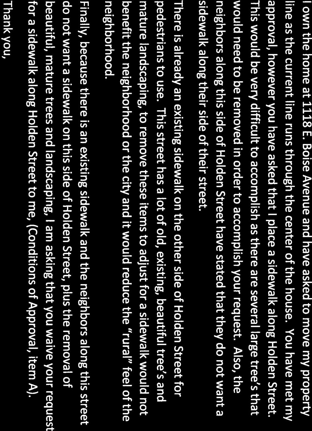
1 SOS / Waiver of Subdivision Standards / John Cashin Summary John Cashin requests a Waiver of Subdivision Standards in the Boise Development Code that requires construction of new sidewalk for approval of a Record of Survey for a Property Line Adjustment. Prepared By David Abo, AICP, Subdivision Analyst Recommendation Approval of SOS Reason for the Decision The request to waive the requirement for constructing a new sidewalk on the west side of South Holden Lane north of East Boise Avenue would not diminish the quality of the development and the public welfare and the interests of the City are protected, the general intent and spirit of the Zoning Ordinance are preserved and conformity to the Comprehensive Plan is assured.
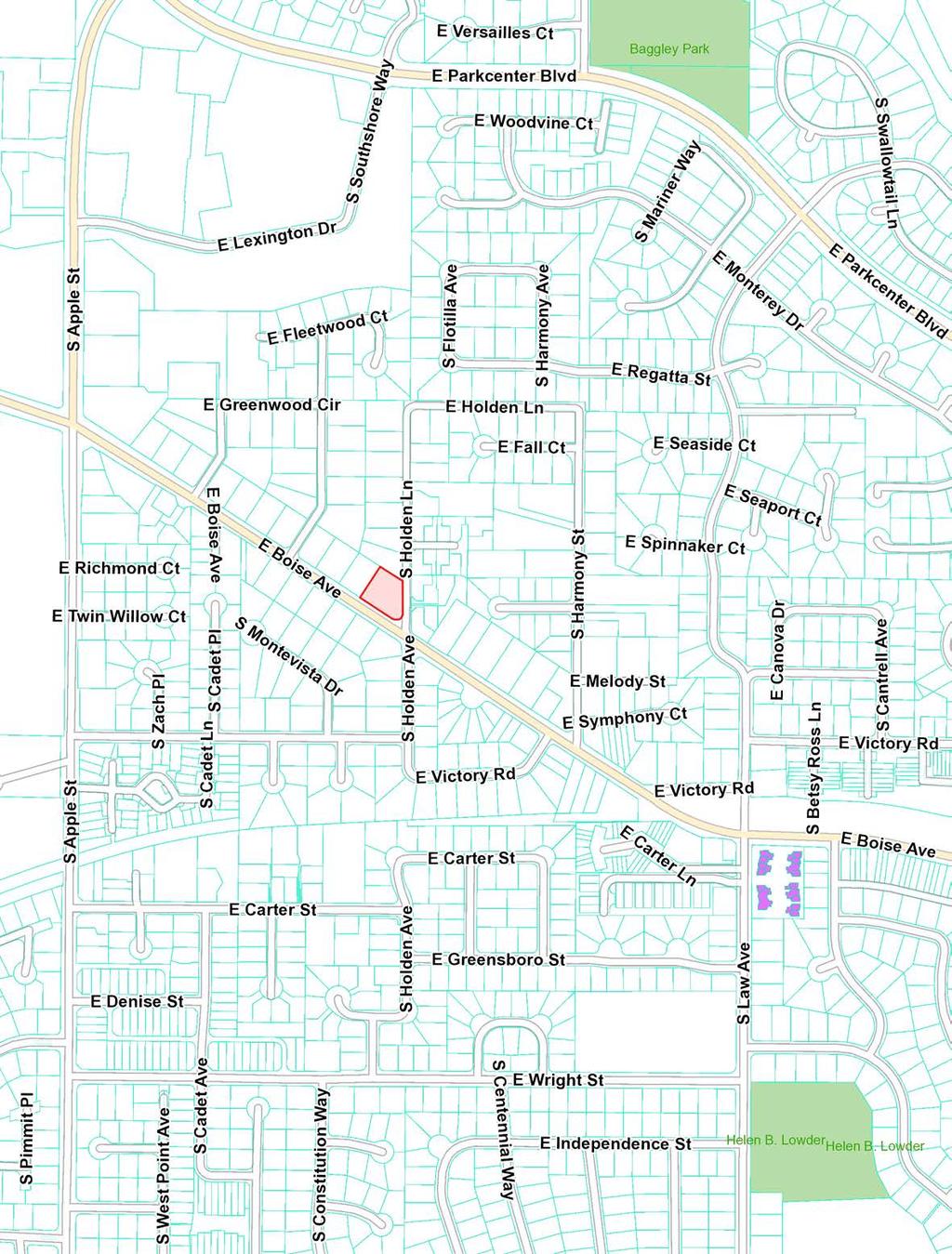
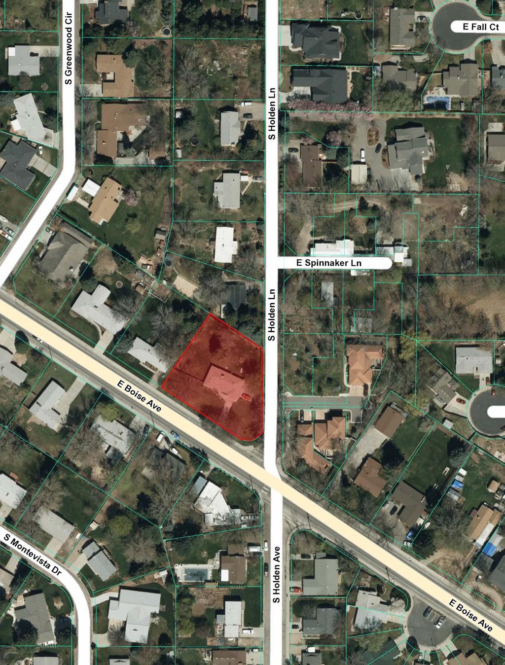
2 Planning Division Waiver Report File Number Applicant Property Address SOS / Waiver of Subdivision Standards John Cashin 1118 East Boise Avenue and 2811 South Holden Lane Public Hearing Date July 13, 2015 Heard by Prepared by Reviewed by Planning and Zoning Commission David Abo, AICP, Subdivision Review Analyst Cody Riddle, Current Planning Manager Table of Contents Page 1. Project Data and Facts 2 2. Land Use 2 3. Development Code 3 4. Comprehensive Plan 3 5. Infrastructure 3 6. Agency Comments 4 7. Analysis/Findings 4 8. Conclusion and Recommendation 5 Exhibits Applicant s Letter 6 ROS Action Letter 7 Maps Vicinity Map 15 Aerial Photo 16 Plat of Greenwood Acres 17
3 SOS / Waiver of Subdivision Standards Boise City Planning and Zoning Commission / July 13, 2015 B 1. Project Data and Facts Project Data Applicant/Status Location of Property Size of Property Zoning Comprehensive Plan Designation Planning Area Neighborhood Assoc./Contact Procedure Current Land Use Description of Applicant s Request John Cashin / Owner 1118 East Boise Avenue and 2811 S. Holden Lane.497 acres R-1C Suburban Southeast Southeast / Brian McDevitt Planning and Zoning Commission is the decision making body. Single-family residential The applicant is requesting a waiver from the requirement to install sidewalks if sidewalks exist on adjoining property as a requirement of a Property Line Adjustment. 2. Land Use Description and Character of Surrounding Area The surrounding area is comprised of predominantly of single-family residential homes. Adjacent Land Uses and Zoning North: Single-Family Residential / R-1C South: East Boise Avenue then Single Family Residential / R-1C East: South Holden Lane then Single-Family Residential / R-1C West: Single-Family Residential / R-1C
4 SOS / Waiver of Subdivision Standards Boise City Planning and Zoning Commission / July 13, 2015 B Site History On June 7, 1948, the plat of the Greenwood Acres Subdivision was recorded. In 1955, the current residence was constructed on Lots 11 and 12 of the Greenwood Acres Subdivision. On April 14, 2015, the applicant submitted an application for a Record of Survey for a Property Line Adjustment (ROS ) to create two parcels with the property line running in an east to west direction whereas the common lot line between Lots 11 and 12 ran in a north to south direction. Lots 11 and 12 front on East Boise Avenue however Lot 12 is a corner lot with frontage on East Boise Avenue and South Holden Lane. East Boise Avenue is constructed with full street improvements including curb, gutter and sidewalk. In 2005, the Ada County Highway District (ACHD) did not require dedication of additional right-of-way or street improvements for South Holden Lane north of the applicant s property for the Holden Subdivision. In 2006, ACHD held a hearing on the Las Ramblas Condominiums which are located on the east side of South Holden Lane across from the applicant s property. At this hearing, the ACHD Commission stated a desire to preserve the current nature of Holden Lane (i.e. large, old growth trees and a narrow driving surface). The Commission determined that South Holden Lane could remain in its current configuration due to the low volume of traffic on South Holden Lane abutting the site and the applicant would not be required to widen the pavement on South Holden Lane or install curb and gutter abutting the site. However the applicant was required to install a 5-foot detached sidewalk. The presence of the mature trees would prevent the installation of sidewalk so the applicant is requesting a waiver to not construct sidewalk for a Property Line Adjustment. 3. Development Code Section Description Specific Procedures for Record of Survey Records of Survey Modifications and Waivers 4. Comprehensive Plan CHAPTER Chapter 2 Predictable Development Plan PRINCIPLES, GOALS, & POLICIES Goal PDP1 A waiver request must be in conformance with the principles, goals and policies of the Boise City Comprehensive Plan. The waiver if granted would allow affordable infill development in a developed neighborhood and maintain the character of the existing neighborhood. 5. Infrastructure The development will be served by existing public water, municipal sewer and public streets.
5 SOS / Waiver of Subdivision Standards Boise City Planning and Zoning Commission / July 13, 2015 B 6. Agency Comments No comments have been received from any agency. 7. Analysis/Findings The Record of Survey (ROS ) was submitted on April 14, The application was reviewed and approved subject to conditions of approval on May 5, 2015 (see attached). Condition of approval 1.A. requires the extension of the existing sidewalk on East Boise Avenue along the east side of South Holden Lane. The waiver provides relief to the strict application of the Ordinance requirements. The Boise City Development Code provides for a Waiver of the Record of Survey requirements when it can be determined that strict application of the Development Code would result in substantial hardship or inequity. The waiver request would not change any of the conditions relating to the site or the approved lot or street layout. BOISE CITY DEVELOPMENT CODE RECORDS OF SURVEY 1. STANDARDS The following divisions of land and/or change of parcel boundaries will require the review and approval of a Record of Survey prepared in accord with Idaho Code, 55-19, to establish that resulting parcels are conforming, buildable parcels. *** B. Property Line Adjustment: A property line adjustment that establishes buildable parcels with boundaries that differ from existing buildable parcel and/or lot boundaries. *** (f) If the street(s) adjacent to the parcel(s) have not been improved with sidewalk, the applicant shall landscape the right-of-way area between the edge of the street pavement and the property line with lawn or other vegetative ground cover that will prevent the area from being used as an off street parking area. Depending on the paved street width, the Ada County Highway District may require some separation between the landscaping and the edge of the street pavement. If the parcel is not alley loaded and has driveways off of the street, the area between the edge of the street pavement and the property line shall be paved to align with the driveway. The applicant shall obtain a license agreement from the Ada
6 SOS / Waiver of Subdivision Standards Boise City Planning and Zoning Commission / July 13, 2015 B County Highway District prior to landscaping and/or paving in the rightof-way. Sidewalks shall be installed if sidewalk exists on adjoining property(s). Section MODIFICATIONS AND WAIVERS 1. Whenever a tract to be subdivided is of such unusual size or shape or is surrounded by such developments or has unusual conditions that the strict application of these regulations would result in substantial hardship or inequity, the Council may waive or modify such requirements so the applicant may develop the property in a reasonable manner, provided the Council finds that the quality of the development is not diminished and the public welfare and the interests of the City are protected, the general intent and spirit of these regulations are preserved and conformity to the Comprehensive Plan is assured. *** D. In the case of a record of survey, the Commission may issue the waiver or modification. 8. Conclusions and Recommendation Conclusions: 1. No sidewalk was required on South Holden Lane when the Greenwood Acres Subdivision was recorded in The applicant can develop the property in a reasonable manner and the quality of the development will not be diminished. 3. The public welfare and interests of the City of Boise are protected and the general intent and spirit of the Boise City Development Code are preserved. 4. Conformity to the Boise City Comprehensive Plan is assured by promoting compact development. Recommendation: The Planning Team recommends approval of the waiver request.

7
8 May 5, 2015 Dean Briggs Briggs Engineering 1800 W. Overland Road Boise, Idaho (sent to: RE: ROS / Property Line Adjustment / 1118 E. Boise Avenue Dear Mr. Briggs: The City Boise Development Services Department has reviewed your application for a lot line adjustment at 1118 E. Boise Avenue within Greenwood Acres Subdivision. This request has been reviewed under Boise City Code (B.C.C.) B. The Planning Team has found that the subject property has met the dimensional requirements for a Property Line Adjustment. Based on the information provided on the application and Record of Survey you are hereby granted approval of the Property Line Adjustment subject to the following Conditions of Approval. CONDITIONS OF APPROVAL 1. Prior to approval of Boise City Planning Director: A. The existing sidewalk on E. Boise Avenue shall be extended along the east side of S. Holden Lane to the northern edge of Parcel. B. Complete corrections from Staff Comments (see attached letters).
9 ROS E. Boise Avenue Boise City Council Notification Issued May 5, 2015 Page 2 of 2 B 2. Prior to issuance of a building permit: A. The Record of Survey must be signed by the Boise City Planning Director and recorded. B. The Notice of Buildable Parcels must signed by the Boise City Planning Director and recorded. C. The Parcels must be recorded by deeds as separate parcels. D. The Parcels must have new tax parcel numbers assigned by the Ada County Assessor. May we also take this opportunity to advise you that this approval will not take effect until after the ten (10) day appeal period has lapsed without an appeal being filed. The decision or any of the conditions attached may be appealed to the Boise City Planning and Zoning Commission within ten (10) days from the date of issuance of this decision. All appeals of this permit must be filed by 5:00 P.M., on May 18, The appeal must be written, accompanied by the appropriate fee, and submitted to the Boise City Planning and Development Services Department prior to the deadline set forth above. Appeal application forms are available at the Boise City Planning and Development Services Department, 2 nd Floor, Boise City Hall, 150 North Capitol Boulevard or online at If you have any questions regarding this approval or any of the Conditions of Approval, please contact me at (208) Sincerely, Ted Vanegas Associate Planner
10 April 14, 2015 PDS Plan Review: ROS This record of survey ROS has been review and PDS Plan Review has no comment at this time. Perry Perry E. Paine Plans Examiner ll #90358 Planning & Development Services 208/ / / Fax
11 ADDRESS NUMBER AUTHORIZATION Address Change/Addition Requested For E Boise Ave New Numbers Assigned 2811 S Holden Ln Requested by City of Boise Date- April 14, 2015 Township 3N, Range 2E, Section 24 Zip code Subdivision - GREENWOOD ACRES Other Designation Current Parcel Number R Reason for Change Address added in preparation for lot split New Address Becomes Official April 14, 2015 All appropriate Federal, County, City agencies, and utilities will be notified of your new address. Issued By: Emily D Dixon Date: April 14, 2015 Boise City Public Works Department Addressing PO Box 500, Boise, Idaho Phone: * If address change is approved by Public Works Addressing department, it does not constitute zoning or building permit approvals. I:\PWA\Subjects\Addressing\Addressing 2015\Addressing Authorization Forms 2015\1118 E Boise Ave.Docx
12 April 7, 2015 Sabrina Durtschi Planning Project Manager 1800 W. Overland Road Boise, ID RE: Available Sanitary Sewer Service (Will Serve) 1118 East Boise Avenue Near E. Boise Ave. and S. Holden Ave. Dear Ms. Durtschi: Please be advised that the above mentioned project is within the City of Boise Sewer Service Area. There is an existing 27-inch public sanitary sewer main located in the public R/W of East Boise Avenue, and an existing 8-inch line in the public R/W of South Holden Avenue. The existing sewer mains are operated and maintained by the City of Boise. The City of Boise will serve this property/project provided it complies with the Boise Municipal Code, Sewer Ordinance. Thank you for your inquiry. If you have any questions, please give me a call at (208) Sincerely, Kyle Rosenmeyer, EIT Associate Civil Engineer c: SF - Sewer Misc & General 2.6
13 April 14, 2015 PW Addressing Plan Review: ROS Parcel A: 1118 E Boise Ave Parcel B: 2811 S Holden Ln Emily Dixon GIS Analyst Public Work Department I:\PWA\Subjects\Addressing\Temp 2015\PWARC ROS Docx
14 04/14/15 ROS B
15
16
17
Time Extension Staff Report
 Time Extension Staff Report Subdivision Name Lunara Subdivision File Number SUB07-00019 Approval Time Extension for Lead Agency Boise City Certification Signature of Boise City Engineer Annexation Date
Time Extension Staff Report
 Time Extension Staff Report Subdivision Name Therrin Subdivision File Number SUB06-00020 Approval Time Extension for Lead Agency Boise City Certification Signature of Boise City Engineer Annexation Date
May we also take this opportunity to inform you of the following:
 September 15, 2009 Curtis Stigers & Amy O Brien Boise, ID 83702 Re: CVA09-00029 / Dear Mr. Stigers & Ms. O Brien: This letter is to inform you of the action taken by the Boise City Planning and Zoning
SOS ; State of Idaho, Consent to Partially Vacate Public Alley Rightof-Way at 611 North 6 th Street
 MEMORANDUM TO: FROM: Mayor and City Council David Abo, AICP Subdivision Review Analyst Boise City Planning and Development Services DATE: November 6, 2012 RE: SOS12-00013; State of Idaho, Consent to Partially
CVA Robert and Renate Bearden
 CVA15-00016 Robert and Renate Bearden Summary Variance to reduce the rear yard setback for a carport located along the alley at 1811 S. Pacific Street in an R-1C (Single Family Residential) zone. Prepared
BOI / DRH Albertsons grocery market and fueling center & pad sites
 Paul Woods, President Rebecca W. Arnold, Vice President Sara M. Baker, Commissioner Jim D. Hansen, Commissioner Kent Goldthorpe, Commissioner March 28, 2017 To: Mark Palmer Albertsons Companies 250 E.
Subdivision Staff Report
 Subdivision Staff Report Subdivision Name Coldstream File Number SUB06-00040 Subdivision Approval Preliminary Plat Lead Agency Boise City Annexation Date December 9, 1974 Comp. Plan Complies Public Hearing
Committed to Service
 Committed to Service Paul Woods, President Rebecca W. Arnold, Vice President Sara M. Baker, Commissioner Jim D. Hansen, Commissioner Kent Goldthorpe, Commissioner August 25, 2017 Development Services TO:
Subdivision Staff Report
 Subdivision Staff Report Subdivision Name Madera Creek File Number SUB06-00068 Subdivision Approval Final Plat Lead Agency Boise City Annexation Date December 9, 1974 Comp. Plan Complies Public Hearing
BYRON TOWNSHIP ZONING APPLICATION
 BYRON TOWNSHIP ZONING APPLICATION Phone: (616) 878-9104 * Fax: (616) 878-3980 * Website: www.byrontownship.org This application will not be accepted if incomplete. APPLICATION FOR & REQUIRED COPIES Private
Hal Simmons Planning Director Boise City Planning and Development Services. CAR / 1689 South Entertainment Avenue
 MEMORANDUM MEMO TO: FROM: Mayor and Boise City Council Hal Simmons Planning Director Boise City Planning and Development Services DATE: November 15, 2008 RE: CAR08-00019 / 1689 South Entertainment Avenue
SECTION 7000 LAND DEVELOPMENT REQUIREMENTS
 SECTION 7000 LAND DEVELOPMENT REQUIREMENTS 7000 LAND DEVELOPMENT REQUIREMENTS... 1 7001 LEGISLATIVE AUTHORITY... 1 7001.1 LAND DEVELOPMENT... 1 7001.1.1 Title 40, Idaho Code... 1 7001.1.2 Idaho Code 40-1415
CAR Judith Balkins
 CAR14-00015 Judith Balkins Summary The applicant requests annexation of approximately 16.3 acres located at 6012 and 6050 N. Pierce Park Lane with R-1B (Single Family Residential) zoning. Prepared By David
May 21, ACHD Board of Commissioners Stacey Yarrington, Planner II DRH /DRH
 Development Services Department May 21, 2013 TO: FROM: SUBJECT: ACHD Board of Commissioners Stacey Yarrington, Planner II DRH13-00106/DRH13-00108 Executive Summary: This is a design review application
Date: March 16, Jake Centers ERD, LLC P.O. Box 1610 Eagle, ID Elevation Ridge Subdivision (SUB & PUD ) Street Address
 Street Address") Rebecca W. Arnold, President Sara M. Baker, Vice President John S. Franden, Commissioner Carol A. McKee, Commissioner David L. Case, Commissioner Date: March 16, 2012 To: Jake Centers ERD, LLC P.O. Box
Rebecca W. Arnold, President Sara M. Baker, Vice President John S. Franden, Commissioner Carol A. McKee, Commissioner David L. Case, Commissioner Date: March 16, 2012 To: Jake Centers ERD, LLC P.O. Box
Subdivision Staff Report
 Subdivision Staff Report Subdivision Name Toli Park Subdivision File Number SUB07-00035 Approval Preliminary Plat Lead Agency Boise City Annexation Date December 30, 1987 Comp. Plan Complies Public Hearing
CITY OF EAU CLAIRE, WISCONSIN. SPECIAL ASSESSMENT POLICY (Dated: November 8, 2016)
") CITY OF EAU CLAIRE, WISCONSIN SPECIAL ASSESSMENT POLICY (Dated: November 8, 2016) (Adopted by reference by Ordinance No. 7207 adopted November 8, 2016) PURPOSE The purpose of this Policy is to assure fair
CITY OF EAU CLAIRE, WISCONSIN SPECIAL ASSESSMENT POLICY (Dated: November 8, 2016) (Adopted by reference by Ordinance No. 7207 adopted November 8, 2016) PURPOSE The purpose of this Policy is to assure fair
ZONING AMENDMENT, SUBDIVISION & SIDEWALK WAIVER REQUEST STAFF REPORT Date: November 16, 2006
 ZONING AMENDMENT, SUBDIVISION & SIDEWALK WAIVER REQUEST STAFF REPORT Date: November 16, 2006 NAME SUBDIVISION NAME Terhaar & Cronley Investment Partnership P & E Subdivision LOCATION 4210 and 4218 Halls
ARTICLE SINGLE FAMILY SITE CONDOMINIUM DEVELOPMENT STANDARDS
 ARTICLE 28.00 SINGLE FAMILY SITE CONDOMINIUM DEVELOPMENT STANDARDS Section 28.01 PURPOSE The purpose of this Article is to recognize that conventional single family developments, traditionally developed
The following application has been scheduled for hearing by the Boise City Council on February 15, 2011:
 MEMORANDUM TO: FROM: Mayor and City Council David Abo, AICP Chief Subdivision Review Analyst Boise City Planning and Development Services DATE: February 8, 2011 The following application has been scheduled
Memorandum: October 13, 2008 REVISED To: Trowbridge Township Planning Commission From: P. Hudson, AICP Re: Suggested New Ordinance
 1 Memorandum: October 13, 2008 REVISED 2-11-09 To: Trowbridge Township Planning Commission From: P. Hudson, AICP Re: Suggested New Ordinance Because of changes in both the Michigan Planning Enabling Act
Location: The subject property is located at the northeast corner of S. Holden Lane and E. Boise Avenue.
 Subdivision Staff Report Subdivision Name Tianna Park File Number SUB11-00008 Approval Preliminary Plat Lead Agency Boise City Annexation Date December 19, 1977 Comp. Plan Complies Public Meeting Date
SUB /CAR /PUD
 Development Services Department Project/File: Lead Agency: Site address: Balntyre Court Subdivision/BPP16-0036/ SUB16-00066/CAR16-00035/PUD16-00040 This is a rezone, planned unit development, and subdivision
PLANNING COMMISSION REPORT Regular Agenda Non Public Hearing Item
 PC Staff Report 3/23/15 FDP-14-00551 Item No. 2-1 PLANNING COMMISSION REPORT Regular Agenda Non Public Hearing Item PC Staff Report 3/23/15 ITEM NO. 2: FINAL DEVELOPMENT PLAN FOR HUTTON FARMS WEST PHASE
TULSA PARK ESTATES SUBDIVISION, RESUBDIVISION OF LOT 6
 TULSA PARK ESTATES SUBDIVISION, RESUBDIVISION OF LOT 6 Engineering Comments: FINAL PLAT COMMENTS (should be addressed prior to submitting the FINAL PLAT for review and/or signature by the City Engineer):
MONTGOMERY COUNTY PLANNING DEPARTMENT THE MARYLAND-NATIONAL CAPITAL PARK AND PLANNING COMMISSION
 MONTGOMERY COUNTY PLANNING DEPARTMENT THE MARYLAND-NATIONAL CAPITAL PARK AND PLANNING COMMISSION MCPB Item No. 8 Date: 03-07-13 Sonoma, Preliminary Plan, 120130040 Melissa Williams, Senior Planner, Melissa.williams@montgomeryplanning.org,
Right-of-Way & Development Services Planning Review Division Committed to Service This application is approved at the staff level on February 1, 2006.
 Right-of-Way & Development Services Planning Review Division Committed to Service This application is approved at the staff level on February 1, 2006. Tech Review for this item was held with the applicant
Planning Department st Avenue East Kalispell, MT Phone: (406) Fax: (406)
 Fax: (406)") Planning Department 201 1 st Avenue East Kalispell, MT 59901 Phone: (406) 758-7940 Fax: (406) 758-7739 www.kalispell.com/planning April 1, 2015 Doug Russell, City Manager City of Kalispell 201 1 st Ave
Planning Department 201 1 st Avenue East Kalispell, MT 59901 Phone: (406) 758-7940 Fax: (406) 758-7739 www.kalispell.com/planning April 1, 2015 Doug Russell, City Manager City of Kalispell 201 1 st Ave
I am submitting to you applications for the Belmar Estates Subdivision, located at 6012 & 6050 N. Pierce Park Lane. These applications include:
 January 27, 2015 Cody Riddle, Manager, Current Planning David Moser, Associate Planner City of Boise Planning & Development Services 150 N. Capitol Boulevard Boise ID 83701 Re: Belmar Estates Subdivision
a. provide for the continuation of collector streets and thoroughfare streets between adjacent subdivisions;
 Section 7.07. Intent The requirements of this Section are intended to provide for the orderly growth of the Town of Holly Springs and its extra-territorial jurisdiction by establishing guidelines for:
USE PERMIT AND VARIANCE APPLICATION
 USE PERMIT AND VARIANCE APPLICATION Case No. BOARD OF ZONING APPEALS APPLICATION FOR USE PERMITS AND VARIANCES ARLINGTON COUNTY, VIRGINIA D E P A R T M E N T O F C O M M U N I T Y P L A N N I N G, H O
Let me know if I need to bring you any other documentation for this withdrawl. Thanks!
 >>> david benoit 11/27/2007 10:00 AM >>> Dave, I am set to be heard on the Cranston Corner Subdivision on December 4th in front of City council. I have sold this property and am requesting
ARTICLE 15 - PLANNED UNIT DEVELOPMENT
 Section 15.1 - Intent. ARTICLE 15 - PLANNED UNIT DEVELOPMENT A PUD, or Planned Unit Development, is not a District per se, but rather a set of standards that may be applied to a development type. The Planned
Executive Summary: This is a preliminary plat to construct 8 residential lots and 2 commons lots with a private road on 3.87-acres in Meridian, Idaho.
 Development Services Department DATE: July 7, 2015 TO: FROM: SUBJECT: ACHD Board of Commissioners Stacey Yarrington, Planner III Kentucky Villas/ MPP15-0012/ PP15-009 Executive Summary: This is a preliminary
Section Preliminary Plat Checklist and Application Forms
 Section 201 - Preliminary Plat Checklist and Application Forms PRELIMINARY SUBDIVISION PLAT REVIEW PROCESS CHART PRELIMINARY SUBDIVISION PLAT APPLICATION PRELIMINARY PLAT REVIEW CHECKLIST CITY OF NAMPA
MONTGOMERY COUNTY PLANNING DEPARTMENT THE MARYLAND-NATIONAL CAPITAL PARK AND PLANNING COMMISSION
 MONTGOMERY COUNTY PLANNING DEPARTMENT THE MARYLAND-NATIONAL CAPITAL PARK AND PLANNING COMMISSION MCPB Item No. Date: 12/4/14 Preliminary Plan No. 120140200, Northwood Knolls Description Patrick Butler,
AAAA. Planning and Zoning Staff Report Lake Shore Land Holdings, LLC CU-PH Analysis
 AAAA Planning and Zoning Staff Report Lake Shore Land Holdings, LLC CU-PH2016-28 Hearing Date: April 21, 2016 Development Services Department Applicant: BRS Architects/Cindy Huebert Staff: Kyle McCormick,
SUBDIVISION DESIGN PRINCIPLES AND STANDARDS
 SECTION 15-200 SUBDIVISION DESIGN PRINCIPLES AND STANDARDS 15-201 STREET DESIGN PRINCIPLES 15-201.01 Streets shall generally conform to the collector and major street plan adopted by the Planning Commission
Subdivision Staff Report
 Subdivision Staff Report Subdivision Name Honeymoon Cove Subdivision File Number SUB08-00005 Approval Preliminary/ Final Plat Lead Agency Boise City Annexation Date December 30, 2004 Comp. Plan Complies
Initial Project Review
 Pierce County Department of Planning and Land Services, 2401 South 35th Street, Tacoma, WA (253) 798-7037 Initial Project Review Major Amendment to Preliminary Plat: Hawks Ridge Division 1 Application
ZONING AMENDMENT & SUBDIVISION STAFF REPORT Date: November 3, 2016
 ZONING AMENDMENT & SUBDIVISION STAFF REPORT Date: November 3, 2016 APPLICANT NAME SUBDIVISION NAME David Shumer 5955 Airport Subdivision CITY COUNCIL DISTRICT District 6 5955 Airport Boulevard, 754 Linlen
If you have any questions, please feel free to contact me at (208)
") Sara M. Baker, President John S. Franden, Vice President Rebecca W. Arnold, Commissioner Mitchell A. Jaurena, Commissioner Jim Hansen, Commissioner Date: March 21, 2013 To: Subject: Hornet Construction
Sara M. Baker, President John S. Franden, Vice President Rebecca W. Arnold, Commissioner Mitchell A. Jaurena, Commissioner Jim Hansen, Commissioner Date: March 21, 2013 To: Subject: Hornet Construction
1. APPLICANT: Polsinelli, Shalton & Welte is the applicant for this request.
 5. REVISED PRELIMINARY PLAN APPROVAL - THE RETREAT AT MAPLECREST - Vicinity of the northeast corner of 159 th Street and U.S. 69 Highway 1. APPLICANT: Polsinelli, Shalton & Welte is the applicant for this
RE: CAR / 4280 N.
 MEMORANDUM TO: FROM: Mayor and Boise City Council Hal Simmons - Planning Director Boise City Planning and Development Services DATE: April 29, 2009 RE: CAR09-00006 / 4280 N. Eagle Road The following application
Subdivision Staff Report
 Subdivision Staff Report Subdivision Name Sunnyridge Subdivision File Number SUB07-00007 Approval Preliminary Plat Lead Agency Ada County Annexation Date NA Comp. Plan Complies (With Conditions of Approval)
BEAR CREEK TOWNSHIP EMMET COUNTY, MICHIGAN. PRIVATE ROAD ORDINANCE Ordinance No. 11A-99. (to replace prior Private Road Ordinance No.
 BEAR CREEK TOWNSHIP EMMET COUNTY, MICHIGAN PRIVATE ROAD ORDINANCE Ordinance No. 11A-99 (to replace prior Private Road Ordinance No. 11-99) An Ordinance to protect the health, safety, and general welfare
1. Preliminary Plat: 2. Final Preliminary Plat (construction):
:") Revised April 12, 2017 The submittal process for plat approval is as follows: 1. Preliminary Plat: A. Submit the following to the Zoning Administrator at the Township Office after attending a preapplication
Revised April 12, 2017 The submittal process for plat approval is as follows: 1. Preliminary Plat: A. Submit the following to the Zoning Administrator at the Township Office after attending a preapplication
The following information is for use by the Lincoln County Planning Board at their meeting/public hearing on February 3, 2014.
 LINCOLN COUNTY PLANNING & INSPECTIONS DEPARTMENT 302 NORTH ACADEMY STREET, SUITE A, LINCOLNTON, NORTH CAROLINA 28092 704-736-8440 OFFICE 704-736-8434 INSPECTION REQUEST LINE 704-732-9010 FAX To: Planning
MINOR SUBDIVISION INFORMATION
 A. POINTS OF CONTACT: MINOR SUBDIVISION INFORMATION Surveyor: Address: Phone #: Fax # E-Mail Address: Representative (If different from applicant): Address: Phone #: Fax # E-Mail Address: B. GENERAL INFORMATION:
Request Subdivision Variance (4.4 (b) of the Subdivision Regulations) Staff Recommendation Approval. Staff Planner Jimmy McNamara
 of the Subdivision Regulations) Staff Recommendation Approval. Staff Planner Jimmy McNamara") Applicant & Property Owner Public Hearing July 12, 2017 City Council Election District Lynnhaven Agenda Item 4 Request Subdivision Variance (4.4 (b) of the Subdivision Regulations) Staff Recommendation
Applicant & Property Owner Public Hearing July 12, 2017 City Council Election District Lynnhaven Agenda Item 4 Request Subdivision Variance (4.4 (b) of the Subdivision Regulations) Staff Recommendation
ARTICLE IV: DEVELOPMENT STANDARDS
 ARTICLE IV: DEVELOPMENT STANDARDS IV-53 409 PRIVATE STREETS A private street means any way that provides ingress to, or egress from, property by means of vehicles or other means, or that provides travel
PLANNED UNIT DEVELOPMENT (PUD) AREA PLAN/REZONING REVIEW PROCEDURE
 AREA PLAN/REZONING REVIEW PROCEDURE") PLANNED UNIT DEVELOPMENT (PUD) AREA PLAN/REZONING REVIEW PROCEDURE Professional inquiries will be made to our Township Planning Consultant, Township Engineer, and Township Attorney to get their opinions
PLANNED UNIT DEVELOPMENT (PUD) AREA PLAN/REZONING REVIEW PROCEDURE Professional inquiries will be made to our Township Planning Consultant, Township Engineer, and Township Attorney to get their opinions
ATTACHMENT 2 PLANNING COMMISSION STAFF REPORT
 ATTACHMENT 2 PLANNING COMMISSION STAFF REPORT ~BEVERLY~RLY Planning C Beverly Hills Planning Division 455 N. Rexford Drive Beverly Hills, CA 90210 TEL. (010) 285-1141 FA)(. (310) 858-5966 mmission Report
SUBDIVISION REGULATIONS
 CHAPTER 41 SUBDIVISION REGULATIONS 41.01 Short Title 41.17 Presentation to Commission or Board of Supervisors 41.02 Purpose 41.18 Subdivision Classified 41.03 Application 41.19 Plats Required 41.04 Recording
# 14 SUB CANAL SUBDIVISION
 CANAL SUBDIVISION Engineering Comments: Label each Lot showing the required minimum finished floor elevation (MFFE). It appears that Lots 2, 3 & 4 are located in the AE Flood Zone; add a note to the plat
ORDINANCE NO. Be it ordained by the City Council of the City of Abilene, Texas:
 ORDINANCE NO. An ordinance repealing Chapter 23, Subpart B of the Code of the City of Abilene, Texas, entitled Mobile Homes and Vacation Travel Trailers; stating the authority; setting forth the scope
Committed to Service. License Agreement Application Form
 Committed to Service License Agreement Application Form PLEASE NOTE: Effective February 16, 2010 - License Agreements within the downtown Boise area for public structures, objects and uses on ACHD sidewalks
TOWN OF OSSIPEE ZONING BOARD OF ADJUSTMENT REQUEST FOR VARIANCE
 TOWN OF OSSIPEE ZONING BOARD OF ADJUSTMENT REQUEST FOR VARIANCE Dear Applicant: You are seeking to apply for a Variance to the Town of Ossipee Zoning Ordinance. When this application is completed and submitted
DAUPHIN CREEK ESTATES SUBDIVISION
 # 12 SUB-000076-2017 DAUPHIN CREEK ESTATES SUBDIVISION Engineering Comments: FINAL PLAT COMMENTS (should be addressed prior to submitting the FINAL PLAT for review and/or signature by the City Engineer):
Committed to Service
 Committed to Service Kent Goldthorpe, President Paul Woods, Vice President Rebecca W. Arnold, Commissioner Sara M. Baker, Commissioner Jim D. Hansen, Commissioner July 18, 2016 Development Services TO:
Chapter Sidewalk Construction and Improvement Standards
 Chapter 19.22 Sidewalk Construction and Improvement Standards 19.22.010 Intent and policy. 19.22.020 Construction of this chapter, statement of purpose, fundamental principle. 19.22.030 Simultaneous construction
REGULAR AGENDA ITEM May 25, 2016 Commission Meeting
 Kent Goldthorpe, President Paul Woods, Vice President Rebecca W. Arnold, Commissioner Sara M. Baker, Commissioner Jim D. Hansen, Commissioner May 13, 2016 TO: FROM; Subject: ACHD Board of Commissioners
ZONING AMENDMENT, PLANNED UNIT DEVELOPMENT & SUBDIVISION STAFF REPORT Date: September 15, 2011
 ZONING AMENDMENT, PLANNED UNIT DEVELOPMENT & SUBDIVISION STAFF REPORT Date: September 15, 2011 NAME SUBDIVISION NAME LOCATION Stratford, L.L.C. Grelot Office Park Subdivision North side of Grelot Road,
CITY OF EMILY VARIANCE APPLICATION
 CITY OF EMILY VARIANCE APPLICATION Please read the Variance Application in its entirety before submitting the application. Applications must be submitted 30 days before the Planning Commission meeting.
Subdivision Staff Report
 Subdivision Staff Report Request Consent to vacate public alley Right-of-Way File Number SOS09-00006 Applicant Gran-Del Petroleum Products, Inc Lead Agency Boise City Alley Public Alley Right-Of-Way Comp.
Subdivision Staff Report
 Subdivision Staff Report Subdivision Name Cayenne Corner File Number SUB06-00060 Subdivision Approval Final Plat Lead Agency Boise City Annexation Date January 1, 1987 Comp. Plan Complies Public Hearing
ELK RAPIDS TOWNSHIP ANTRIM COUNTY, MICHIGAN ORDINANCE NO
 ELK RAPIDS TOWNSHIP ANTRIM COUNTY, MICHIGAN ORDINANCE NO. 3-2011 AN ORDINANCE TO REPLACE THE SUBDIVISION CONTROL ORDINANCE WITH A NEW SUBDIVISION DEVELOPMENT ORDINANCE, IN ACCORD WITH THE LAND DIVISION
Date: August 29, Dave Scaggs (sent via ) Summit Development Inc th Ave. Rd. #384 Nampa, ID 83686
 Summit Development Inc th Ave. Rd. #384 Nampa, ID 83686") Sara M. Baker, President John S. Franden, Vice President Rebecca W. Arnold, Commissioner Mitchell A. Jaurena, Commissioner Jim Hansen, Commissioner Date: August 29, 2013 To: Dave Scaggs (sent via email)
Sara M. Baker, President John S. Franden, Vice President Rebecca W. Arnold, Commissioner Mitchell A. Jaurena, Commissioner Jim Hansen, Commissioner Date: August 29, 2013 To: Dave Scaggs (sent via email)
APPLICATION PROCEDURE
 ANTRIM PLANNING BOARD P. O. Box 517 Antrim, New Hampshire 03440 Phone: 603-588-6785 FAX: 603-588-2969 APPLICATION FORM AND CHECKLIST FOR MINOR OR MAJOR SITE PLAN REVIEW File Date Received By APPLICATION
ORDINANCE NO. 41. PRIVATE ROAD ORDINANCE As Amended Through April 10, 2008
 ORDINANCE NO. 41 PRIVATE ROAD ORDINANCE As Amended Through April 10, 2008 An Ordinance to protect the health, safety, and general welfare of the inhabitants of Port Sheldon Township. The Township of Port
# 1 HOLDOVER Revised SUB CANAL SUBDIVISION
 CANAL SUBDIVISION Engineering Comments: Label each Lot showing the required minimum finished floor elevation (MFFE). It appears that Lots 2, 3 & 4 are located in the AE Flood Zone; add a note to the plat
ELMORE COUNTY LAND USE & BUILDING DEPARTMENT 520 E 2 nd South Mountain Home, ID (208) Preliminary Plat Application
 Preliminary Plat Application") ELMORE COUNTY LAND USE & BUILDING DEPARTMENT 520 E 2 nd South Mountain Home, ID 83647 (208) 587-2142 www.elmorecounty.org Preliminary Plat Application We are unable to accept facsimile copies. (Subdivisions
ELMORE COUNTY LAND USE & BUILDING DEPARTMENT 520 E 2 nd South Mountain Home, ID 83647 (208) 587-2142 www.elmorecounty.org Preliminary Plat Application We are unable to accept facsimile copies. (Subdivisions
APPLICANT NAME SUBDIVISION NAME DEVELOPMENT NAME LOCATION. CITY COUNCIL DISTRICT Council District 4 PRESENT ZONING PROPOSED ZONING
 SUBDIVISION, PLANNED UNIT DEVELOPMENT, PLANNING APPROVAL, ZONING AMENDMENT, & SIDEWALK WAIVER REQUEST STAFF REPORT Date: February 17, 2010 APPLICANT NAME SUBDIVISION NAME DEVELOPMENT NAME LOCATION David
VERGENNES TOWNSHIP, KENT COUNTY, MICHIGAN ORDINANCE AMENDMENT Ordinance Adopted May 17, 2004
 VERGENNES TOWNSHIP, KENT COUNTY, MICHIGAN ORDINANCE AMENDMENT Ordinance 2004-8 Adopted May 17, 2004 Private Road Ordinance Amendments An ordinance to amend portions of Section 202.000 Private Roads. The
TOWN OF EASTCHESTER BUILDING AND PLANNING DEPARTMENT PLANNING BOARD APPLICATION PACKAGE SUBDIVISIONS
 TOWN OF EASTCHESTER BUILDING AND PLANNING DEPARTMENT 40 Mill Road (914) 771-3317 building@eastchester.org Eastchester, NY 10709 (914) 771-3322 Fax www.eastchester.org TABLE OF CONTENTS PLANNING BOARD APPLICATION
Parkland-Spanaway-Midland LUAC - Agenda
 1. 6:30 P.M. Parkland-Spanaway-Midland LUAC - Agenda Documents: 8 2 17 PSMAC Agenda.pdf 2. Parkland-Spanaway-Midland LUAC Initial Project Review Documents: Lincoln Court PP IPR PSMAC-RJ.pdf Department
ORDINANCE NO
 PLEASE TAKE NOTICE that the following Ordinance was introduced on first reading by the Township Committee of the Township of Kingwood, County of Hunterdon, State of New Jersey at a meeting held on the
PLANNING COMMISSION REPORT REGULAR AGENDA
 PP-4-4-11 Item No. 9-1 PLANNING COMMISSION REPORT REGULAR AGENDA PC Staff Report 06/22/11 ITEM NO 9: PRELIMINARY PLAT; KASOLD WATER TOWER ADDITION; SE OF TAM O SHANTER & KASOLD DR (MKM) PP-4-4-11: Consider
Staff Report PLANNED DEVELOPMENT. Salt Lake City Planning Commission. From: Lauren Parisi, Associate Planner; Date: December 14, 2016
 Staff Report PLANNING DIVISION COMMUNITY & NEIGHBORHOODS To: Salt Lake City Planning Commission From: Lauren Parisi, Associate Planner; 801-535-7932 Date: December 14, 2016 Re: 1611 South 1600 East PLANNED
Waseca County Planning and Zoning Office
 Waseca County Planning and Zoning Office 300 North State Street Waseca, Minnesota 56093 Phone: 507-835-0650 Fax: 507-837-5310 Form no. PZ 081009 Web Site: www.co.waseca.mn.us FEES: 1) CUP FEE- $400.00
Planning Grant Contract No. SC P-8 (G) South Carolina State Development Board Division of Community Planning of the Development and Research Center
 South Carolina State Development Board Division of Community Planning of the Development and Research Center") SUBDIVISION REGULATIONS Prepared for: Planning and Zoning Commission Anderson, South Carolina The preparation of this report was financed in part through an Urban Planning grant from the Department of
SUBDIVISION REGULATIONS Prepared for: Planning and Zoning Commission Anderson, South Carolina The preparation of this report was financed in part through an Urban Planning grant from the Department of
Planning & Zoning Commission
 Planning & Zoning Commission Preliminary Plat Tuscan Lakes, SF 55-3 and 60-3 SE Planning & Development Department May 4, 2015 Request Applicant Owner Zoning Location Attachments Subdivide approximately
THE REDEVELOPMENT PLAN
 PAGE 37 THE REDEVELOPMENT PLAN FUTURE LAND USE The Silver Terrace Redevelopment Area is currently designated as Redevelopment Area #4 on the City of Delray Beach Future Land Use Map (FLUM). This designation
PLANNED UNIT DEVELOPMENT & SUBDIVISION STAFF REPORT Date: April 18, 2019
 PLANNED UNIT DEVELOPMENT & SUBDIVISION STAFF REPORT Date: April 18, 2019 DEVELOPMENT NAME SUBDIVISION NAME Springhill Village Subdivision Springhill Village Subdivision LOCATION 4350, 4354, 4356, 4358,
Administrative Review Application Blair Township, Grand Traverse County. Blair Township
 Blair Township ZONING DEPARTMENT 2121 Co. Rd. 633 Grawn, MI 49637 231.276.9263 Applications will NOT be accepted unless ALL information and fully completed application are submitted. Please take note of
LARAMIE COUNTY PLANNING & DEVELOPMENT DEPARTMENT
 LARAMIE COUNTY PLANNING & DEVELOPMENT DEPARTMENT Planning Building MEMORANDUM TO: FROM: Laramie County Planning Commission Brett Walker, Planner DATE: January 25, 2018 TITLE: Review and action of a Subdivision
STAFF REPORT FOR MAJOR SUBDIVISION
 STAFF REPORT FOR MAJOR SUBDIVISION FINAL PLAT CASE NO. FA-14-001 HEARING DATE: January 6, 2016 CASE NAME: Solterra Subdivision Filing No. 16 PROCEDURE: Planning Commission ADDRESS OF MAJOR SUBDIVISION
MAJOR ISSUES DISCUSSED To date, there has been no opposition to this request and no member of the public has testified. ***
 CAR07-00051 Page 2 SUMMARY Larry and Barbara Woolf request approval to rezone ± 1.33 acres from R-1C (Single Family Residential with a maximum of 8.0 DU/acre) to R-2D (Combined Residential with a maximum
STAFF REPORT FOR MAJOR SUBDIVISION
 STAFF REPORT FOR MAJOR SUBDIVISION FINAL PLAT CASE NO. FA-12-003 HEARING DATE: November 6, 2013 CASE NAME: Solterra Subdivision Filing No. 13 PROCEDURE: Planning Commission ADDRESS OF MAJOR SUBDIVISION
#1 (CAR /SUB )
") Development Services Department Project/File: Lead Agency: Site address: Fork South #1 (CAR14-00009/SUB14-00024) The applicant is requesting annexation, rezone and preliminary plat approvals for a 52-lot
Development Services Department Project/File: Lead Agency: Site address: Fork South #1 (CAR14-00009/SUB14-00024) The applicant is requesting annexation, rezone and preliminary plat approvals for a 52-lot
ZONING AMENDMENT & SUBDIVISION STAFF REPORT Date: July 9, 2015
 ZONING AMENDMENT & SUBDIVISION STAFF REPORT Date: July 9, 2015 APPLICANT NAME 2513 Dauphin Street, Inc. SUBDIVISION NAME Audubon Place Extension No. 3, Resubdivision of Lots 1-5 LOCATION 2513 Dauphin Street
Request for Action form is also defined as an application to be considered by the Planning Commission.
 CITY OF NORTH RIDGEVILLE INSTRUCTIONS FOR FILING REQUEST FOR ACTION APPLICATIONS WITH THE PLANNING COMMISSION (Please read the full instruction as it will help in providing a full complete application)
CHAPTER 22 SUBDIVISION AND LAND DEVELOPMENT
 CHAPTER 22 SUBDIVISION AND LAND DEVELOPMENT 22-101. Title 22-102. Legislative Intent Part 1 General Provisions 22-201. Development Permits Part 2 Administration 22-301. Fee Schedule Part 3 Fee Schedule
Application: Z Owner: D & S Schulz Enterprises Ltd. Address: 196 Cariboo Rd Applicant: Siegfried Schulz. RU6 - Two Dwelling Housing
 REPORT TO COUNCIL Date: October 3, 2016 RIM No. 1250-30 To: From: City Manager Community Planning Department (TY) Application: Z16-0018 Owner: D & S Schulz Enterprises Ltd Address: 196 Cariboo Rd Applicant:
APPLICATION SUBMITTAL REQUIREMENTS FOR Tentative Parcel or Subdivision Maps
 CITY OF EL CERRITO Community Development Department Planning and Building Division 10890 San Pablo Avenue, El Cerrito, CA 94530 (510) 215-4330 FA (510) 233-5401 planning@ci.el-cerrito.ca.us APPLICATION
McGowin Park, LLC. B-3, Community Business District
 # 10, 11, 12 SUB2014-00024 ZON2014-00500 ZON2014-00501 SUBDIVISION, PLANNED UNIT DEVELOPMENT (East), PLANNED UNIT DEVELOPMENT (West) STAFF REPORT Date: April 3, 2014 DEVELOPMENT NAME LOCATION McGowin Park,
BOSSIER CITY PARISH METROPOLITAN PLANNING COMMISSION 620 Benton Rd. Bossier City, LA Phone: Fax: PRELIMINARY PLAT
 (OFFICE USE ONLY) Application Fee: Paid: Date: CASE # Project Information BOSSIER CITY PARISH METROPOLITAN PLANNING COMMISSION 620 Benton Rd. Bossier City, LA 71111 Phone: 318-741-8824 Fax: 318-741-8827
Spence Carport Variance
 Spence Carport Variance ACTIVITY #: BOARD OF ADJUSTMENTS HEARING DATE: PL-15-1042 12/14/2015 at 6:00 pm PETITIONER: PETITION: LOCATION: ZONE DISTRICT: AREA OF PARCEL: REQUIRED SETBACKS: STAFF CONTACT:
1017 S. MILLS AVE. DRIVEWAY
 Staff Report to the Board of Zoning Adjustment January 27, 2015 VAR2014-00119 I TEM #2 1017 S. MILLS AVE. DRIVEWAY S. MILLS AVE. Location Map S UMMARY Applicant/Owner Jack Elkins Project Planner Jim Burnett,
TENTATIVE MAP APPLICATION GUIDE (BCC 20-1)( 20-2 to )( to 20-91)( to )
( 20-2 to )( to 20-91)( to )") Butte County Department of Development Services PERMIT CENTER 7 County Center Drive, Oroville, CA 95965 Planning Division Phone 530.552.3701 Fax 530.538.7785 Email dsplanning@buttecounty.net FORM NO PLG-05
Butte County Department of Development Services PERMIT CENTER 7 County Center Drive, Oroville, CA 95965 Planning Division Phone 530.552.3701 Fax 530.538.7785 Email dsplanning@buttecounty.net FORM NO PLG-05