Subdivision Staff Report
|
|
|
- Aron Ball
- 5 years ago
- Views:
Transcription

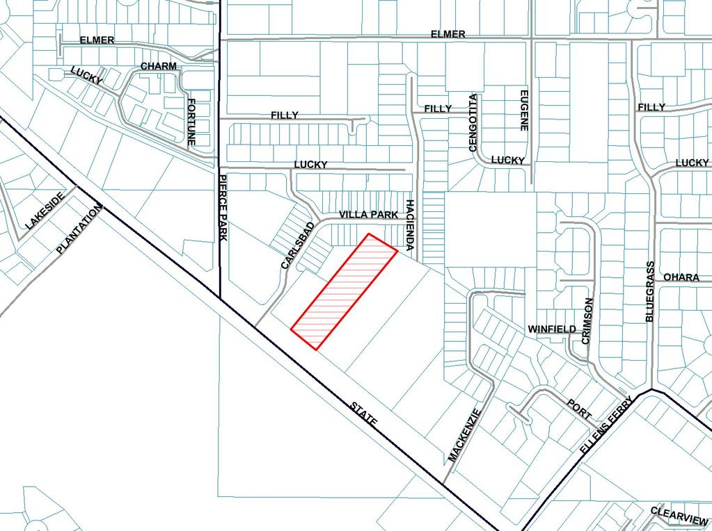
1 Subdivision Staff Report Subdivision Name Toli Park Subdivision File Number SUB Approval Preliminary Plat Lead Agency Boise City Annexation Date December 30, 1987 Comp. Plan Complies Public Hearing Date June 19, 2007 Heard by Boise City Council Planning and Zoning Commission Approval May 14, 2007 Staff David Abo, AICP Description: This is a proposed mixed use subdivision with 10 single-family residential lots, one commercial lot and six common lots on 1.88 acres. The density of the subdivision is 7.69 dwelling units per acre. The subject property is currently zoned C-4D. There is an associated Conditional Use Permit application (CUP ) with the subdivision. Residential development in the C-4 zone is allowed by a conditional use permit. The subject property is currently improved with a single family residence. The applicant has indicated that the existing structure will be removed. Location: The subject property is located on the north side of W. State Street approximately 350 feet east of N. Pierce Park Lane. Traffic: This development is estimated to generate 179 additional vehicle trips per day (10 existing) based on the Institute of Transportation Engineers Trip Generation Manual for single family detached dwellings, general office & retail land use designations. Roadway Frontage Functional Classification W. State 100-Feet Principal Street Arterial N. Pierce Park Lane 0-Feet Major Collector Traffic Count 40,278 east of Gary Lane on 8/4/03 40,906 west of Hertford Way on 4/13/04 7,588 north of State Street on 9/1/05 1,355 south of Hill Road on 1/5/05 Level of Speed Service* Limit LOS E 45 MPH Better than LOS C 35 MPH N. Carlsbad Way 0-Feet Local Residential N / A N/A 20 MPH *Acceptable level of service for a five-lane principal arterial roadway is D (33,000 ADT). *Acceptable level of service for a two-lane Major Collector roadway is D (9,500 ADT).
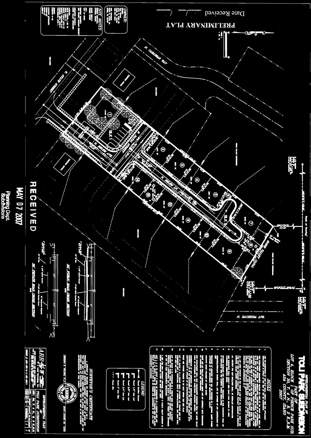
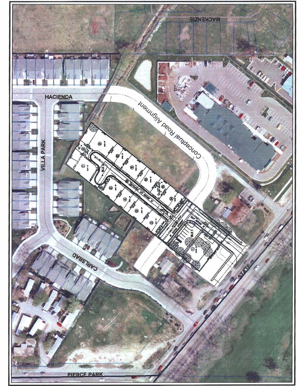
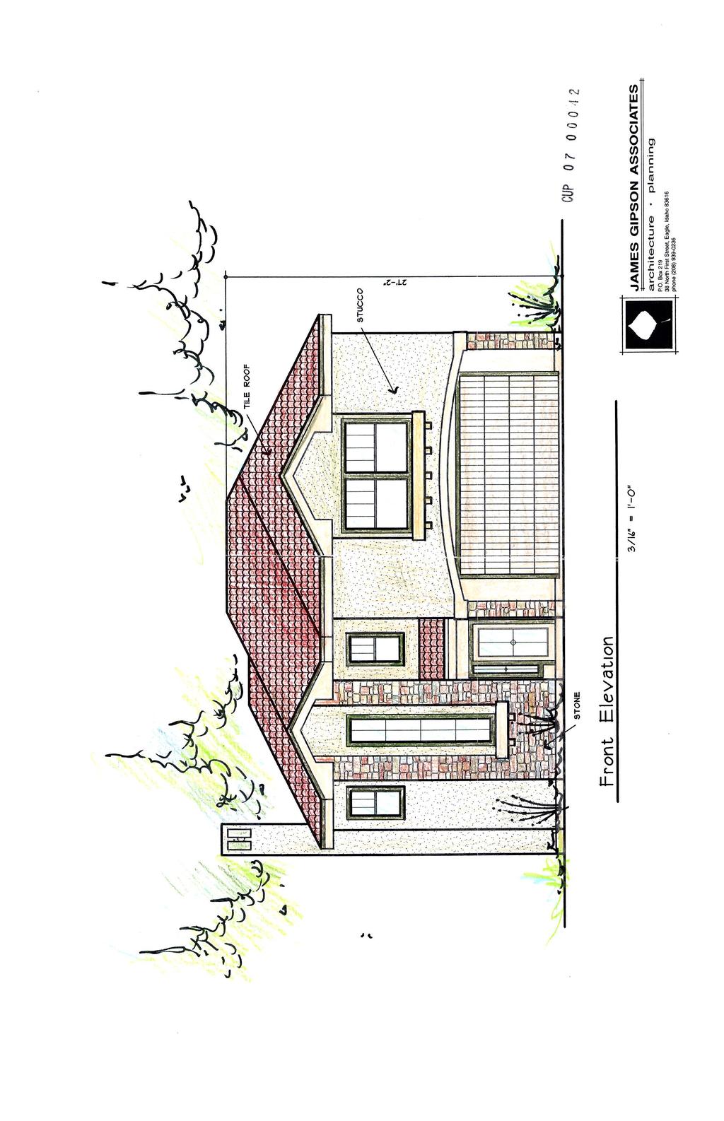
2 2 of 25 *Acceptable level of service for a local roadway is 2,000 ADT. Capital Improvements Plan/Five Year Work Program: There are currently no roadways, bridges or intersections in the general vicinity of the project that are currently in the Five Year Work Program or the Capital Improvements Plan. West State Street is listed in the CIP for construction to a 7-lane roadway. Contents: Basis for Recommendation Vicinity map Preliminary Plat Aerial Map Building Elevations approved with CUP Recommended Conditions of Approval Technical Review and Agency Comments
3 3 of 25 Basis for Recommendation The Boise City Planning and Zoning Commission recommended approval of the Preliminary Plat of the Toli Park Subdivision on May 14, The Commission approve CUP on May 14, 9, No appeal has been filed on that approval. The plat design and layout is in conformance with the Comprehensive Plan and complies with the basic requirements of the Boise City Subdivision and Zoning Ordinances. Condition 1 Condition 2 Condition 3 Condition 4 This condition requires compliance with the associated Conditional Use Permit (CUP ). This condition requires that the Final Plat show any common access easements for shared driveways. This condition addresses the proposed common lots. This condition requires the extension of stub streets. Condition 5 This condition approves a Waiver to the Subdivision Ordinance allowing a 30 foot wide private street right-of-way and a four foot wide sidewalk located within an easement on both sides of the proposed private street. Condition 6 This condition addresses on-street parking as per the International Fire Code. Staff Perspective General The recommended conditions of approval are required to bring the proposed Preliminary Plat into compliance with City and State Codes and have been confirmed by the Planning and Development Services Department. Staff has reviewed the agency comments and Staff recommends approval based upon Staff's finding that all concerns of the commenting agencies have been addressed. To avoid potential problems the developer is directed to review the concerns identified in the technical reviews to verify that this statement is correct. Street Connectivity The subject property is bordered on the south by West State Street. There are large parcels located on the east and west of the subject property. The applicant is proposing public stub street connections to each parcel on the east and west. The parcel to the north is developed Sidewalk Design The applicant is proposing to construct a five foot sidewalk 53 feet from the center line of W. State Street as per the Ada County Highway Districts recommendation. The sidewalk distance from W. State Street is to accommodate the future widening of W. State Street to seven lanes. The applicant is also proposing to construct a five foot wide sidewalk along both sides of the
4 4 of 25 proposed public streets (N. Belem Avenue & W. Natal Street). The applicant is also proposing to construct a four foot wide attached sidewalk along both sides of the proposed private street. None known. Conditions in Dispute
5
6
7
8
9
10 5 of 25 Recommended Conditions of Approval Special Conditions and Plat Notes 1. The subdivision plat shall comply with the site plan and all conditions of approval for CUP , and a note on the face of the Final Plat is required stating, "The development of this property shall be in compliance with the Boise City Zoning Ordinance or as specifically approved by CUP " 2. Prior to signature of the Final Plat by the City Engineer, any common access easements for shared driveways shall be shown on the Final Plat. 3. Lots 1, 6, 8, 13, 15, Block 2 are common a lots to be used for open space. A note on the face of the Final Plat shall state: Lots 1, 6, 8, 13, 15, Block 2 are a common lots to be used for open space which shall be owned and maintained by the Toli Park Homeowner s Association. These lots cannot be developed for residential purposes in the future 4. W. Natal Street shall be stubbed to the eastern and western property lines of the subject property. 5. A Waiver of the Subdivision Ordinance ( E.4.a) is hereby granted allowing a 30 foot wide private street right-of-way which serves more than 10 lots and a four foot wide sidewalk located within an easement on both sides of the proposed private street. 6. For streets having a width less than 36 feet back of curb to back of curb parking shall be restricted on (1) one side; for streets having a width less than 29 feet back of curb to back of curb parking shall be restricted on both sides; and for standard ACHD cul-de-sacs parking shall be restricted on both sides. A note on the face of the Final Plat is required noting the parking restriction prior to signing of the Final Plat by the Boise City Engineer. Covenant Requirements 7. Covenants, homeowners association by-laws or other similar deed restrictions acceptable to the Boise City Attorney, which provide for the use, control and maintenance of all common areas, storage facilities, recreational facilities or open spaces shall be reviewed and approved by the Boise City Attorney. Erosion Control Requirements 8. Prior to the City Engineer's Certification of the Final Plat and prior to earth disturbing activities, an erosion and sediment control (ESC) permit must be obtained. An ESC plan conforming to the requirements B.C.C. Title 8 Chapter 17, is to be submitted to the Director of Planning and Development Services for review and approval. No grading or earth disturbing activities may start until an approved ESC permit has been issued.
11 6 of An individual who has attended the Boise City Responsible Person (RP) certification class, or has obtained Interim Certification for Responsible Person is not identified for this project. A permit will not issue until such time as the name and certification number of the RP has been provided to Boise City. This information can be faxed to or ed to swebb@cityofboise.org. Drainage Conditions 10. Subdivision drainage shall be in accordance to B.C.C E. The developer shall submit a letter from the appropriate drainage entity approving the drainage system or accepting the drainage there from; or submit a letter from a registered professional engineer certifying that all drainage shall be retained on-site. A copy of the construction drawing(s) depicting all site drainage improvements shall be submitted with the letter. A. Developer may either construct improvement prior to Final Platting or post bond in the amount of 110% of the estimated construction costs. Estimated construction costs shall be provided by the developer's engineer. B. For drainage facilities located outside of the public right-of-way, the developer shall dedicate a storm drainage easement. Said easement shall be labeled as either an Ada County Highway District storm drainage easement or a homeowners association storm drainage easement, depending on what entity will assume responsibility for the operation and maintenance of the storm drainage system. C. Should the homeowners association be responsible for the operation and maintenance of the storm drainage facilities, covenants, homeowners association by-laws or other similar deed restrictions acceptable to the Boise City Attorney shall be reviewed and approved by the Boise City Attorney. Irrigation Conditions 11. Comply with Idaho Code Section and Boise City Code Section J concerning pressure irrigation requirements prior to signing of the Final Plat by the Boise City Engineer. A. The owner or person, firm or corporation filing the subdivision plat shall provide a pressurized irrigation system. The system must conform to the minimum design standards and specifications of Boise City or of the entity that will operate and maintain the system, if that entity has published standards. 1) Fees: Developer and/or owner shall pay the current inspection and plan review fees on the proposed subdivision prior to signing of the Final Plat by the Boise City Engineer (B.C.C ). B. Developer may construct prior to Final Platting or bond in the amount of 110% of the estimated construction costs.
12 7 of 25 C. Prior to either commencing construction or signing of the Final Plat by the Boise City Engineer, developer shall: 1) Submit construction plans and specifications for the pressurized system, stamped by a registered engineer, to the Department of Public Works and acquire approval there from. 2) Provide written assurance that provisions have been made for ownership, operation, and maintenance of the system. 3) Delineate all necessary irrigation easements on the Final Plat (B.C.C F). D. Developer shall provide for an independent inspection of the installation of irrigation facilities and written certification by the design or project engineer that the system was installed according to the approved plans. In addition, the Department of Public Works must be present for the system pressure test and participate in a final inspection. 12. No ditch, pipe or structure for irrigation water or irrigation waste water shall be obstructed, rerouted, covered or changed in any way unless such obstruction, rerouting, covering or changing has first been approved in writing by the ditch company officer in charge. A. A copy of such written approval by the ditch company officer shall be filed with the construction drawing and submitted to the Department of Planning and Development Services prior to signing of the Final Plat by the Boise City Engineer (B.C.C F.2). 13. Fence, cover or tile all irrigation ditches, laterals or canals and drains, exclusive of natural waterways, intersecting, crossing or lying adjacent to the subdivision prior to Final Platting or post bond in the amount of 110% of the estimated improvement cost with the Boise City Planning and Development Services Department. "Adjacent" is defined by the Boise City Code as "located within less than sixty feet (60') of any lot included in the development." A. Any covering or fencing program involving the distribution of any irrigation district shall have the prior approval of the affected district. B. If the developer requests a water amenity, such request shall comply with B.C.C F.5. C. Fencing shall be installed within 90 days of the issuance of the first building permit in the development, if building permits are obtained prior to completion of fencing improvements. Private Street Conditions
13 8 of The following private street requirements must be met: A. A restrictive covenant for maintenance shall be recorded at the time of recording the plat which covenant, (a) creates the formation of a homeowners association for the perpetual requirement for the maintenance of the private street, and private street signs and (b) provides that said covenant shall run with the land, and (c) provides that the homeowners association shall not be dissolved without the express consent of Boise City. B. Said easement and covenant to be reviewed and approved by the Boise City Attorney (B.C.C E.3.p). 15. Private street widths shall be in conformance with B.C.C E.4 or as allowed via B.C.C All private streets, base and pavement, shall be constructed to the same construction specifications required for public streets. Contact the Ada County Highway District for public street construction requirements (B.C.C E). A. Prior to submitting the Final Plat, certification of construction to A.C.H.D. specifications is required from an independent testing laboratory or a consulting engineer, including test results for the verification of construction (B.C.C E.3.s). B. Sidewalks are required on both sides of the private street (or in compliance with the sidewalk plan approved with the conditional use) unless specifically waived by the Boise City Council. C. Private street signs shall be installed in the same manner as Public Street signs (see requirements of A.C.H.D.) D. The developer shall pay the current drainage review and inspection fees on the proposed subdivision (B.C.C E.3.q). E. Prior to submitting the Final Plat, drainage facilities for the private street shall comply with Boise City s Storm Water Management and Discharge Control Ordinance (B.C.C. 8-15). Plans shall be approved and construction inspected by Boise City Public Works. 16. Developer and/or owner may either construct prior to Final Platting or post bond/agreement in the amount of 110% of the estimated costs, including certification (B.C.C E.3.r). Sewer Conditions 17. Wet line sewers are required (B.C.C D.). A. Plans shall be submitted to and approved by the Boise City Department of
14 9 of 25 Public Works prior to commencing with construction. Developer and/or owner may either construct improvements prior to Final Platting or execute a performance agreement and provide surety in the amount of 110-% of the estimated costs. The developer shall coordinate with the Department of Public Works for construction inspection prior to and during construction. Unless otherwise approved by the Public Works Department, all sewer construction shall be completed and accepted within 90 days of plat recordation or within 30 days of issuance of the first Building Permit within the subdivision, whichever comes first. NOTE: All bonding shall conform to Boise City Code, Title 8, Chapter 20. B. Developer and/or owner shall pay the current sewer inspection fees for the proposed subdivision prior to signing of the Final Plat by the Boise City Engineer. 18. The developer and/or owner shall delineate all necessary Boise City sanitary sewer easements on the Final Plat prior to signing of the Final Plat by the Boise City Engineer (B.C.C F). 19. Developer and/or owner unless previously paid, shall pay a sewer assessment along State Street and/or as may be approved by the Boise City Public Works Commission prior to the signing of the Final Plat by the Boise City Engineer. Contact the Department of Public Works for specific costs. General Conditions 20. The developer shall make arrangements to comply with all requirements of the Boise City Fire Department and verify in one of the following ways: A. A letter from the Boise City Fire Department stating that all conditions for water, access, and/or other requirements have been satisfied, B. A non-build agreement has been executed and recorded with a note on the face of the Final Plat identifying the instrument number. OR NOTE: No Parking signs and curb painting shall be required on streets having a width less than 36-feet, back of curb to back of curb. Contact the Boise City Fire Department for sign placement and spacing. Developer may either construct prior to Final Platting or post bond in the amount of 110% of the estimated costs with the Boise City Planning and Development Services Department. 21. The name, Toli Park Subdivision, is reserved and shall not be changed unless there is a change in ownership, at which time, the new owner(s) shall submit their new name to the
15 10 of 25 Ada County Surveyor for review and reservation. Should a change in name occur, applicant shall submit, in writing, from the Ada County Surveyor, the new name to the Department of Planning and Development Services and re-approval by the Council of the "revised" Final Plat shall be required. Developer and/or owner shall submit all items including fees, as required by the Planning and Development Services Department, prior to scheduling the "revised" Final Plat for hearing. 22. Correct street names as approved by the Ada County Street Name Committee shall be placed on the plat (I.C. Title 50, Chapter 13). 23. A letter of acceptance for water service from the utility providing same is required (B.C.C C). 24. A letter from the appropriate school district is required stating, "The Developer has made arrangements to comply with all requirements of the School District." 25. Developer shall provide utility easements as required by the public utility providing service (B.C.C F). 26. Developer shall provide a letter from the United States Postal Service stating, "The Developer and/or Owner have received approval for location of mailboxes by the United States Postal Service." Contact: Steve Whitehead, Postmaster 770 S. 13th St. Boise, ID Phone No. (208) FAX No. (208) Approval of sewer and water facilities by the Central District Health Department is required (I.C. Title 50, Chapter 13). 28. Developer shall comply with all construction standards of Ada County Highway District including approval of the drainage plan, requirements for installing curb, gutter, sidewalks and paving throughout the subdivision as specified by the Boise City Council. Signature by the Ada County Highway District on the plat is required (I.C. Title 50, Chapter 13). 29. Prior to submitting the Final Plat for recording, the following endorsements or certifications must be executed: Signatures of owners or dedicators, Certificate of the Surveyor, Certificate of the Ada County Surveyor, Certificate of the Central District Health Department, Certificate of the Boise City Engineer, Certificate of the Boise City Clerk, signatures of the Commissioners of the Ada County Highway District and the Ada County Treasurer (I.C. Title 50, Chapter 13). 30. Developer shall comply with B.C.C D.2 which specifies the limitation on time for filing and obtaining certification. Certification by the Boise City Engineer shall be made within two years from date of approval of the Final Plat by the Boise City Council.
16 11 of 25 A. The developer may submit a request for a time extension, including the appropriate fee, to the Boise City Planning and Development Services Department for processing. Boise City Council may grant time extensions for a period not to exceed one year provided the request is filed, in writing, at least twenty working days prior to the expiration of the first two year period, or expiration date established thereafter. B. If a time extension is granted, the Boise City Council reserves the right to modify and/or add condition(s) to the original preliminary or Final Plat to conform with adopted policies and/or ordinance changes. C. The Final Plat shall be recorded with the Ada County Recorder within one year from the date of the Boise City Engineer s signature. If the Final Plat is not recorded within the one-year time frame it shall be deemed null and void. 31. No building permit for the construction of any new structure upon property within a proposed subdivision plat shall be accepted until the Final Plat has been recorded pursuant to the requirements of the Boise City Subdivision Ordinance, Section A The Toli Park Subdivision is approved for 10 residential lots, one commercial lot and six common lots.
17 12 of 25 Technical Review and Agency Comments Boise City Planning and Development Services: Subdivision Section Todd Tucker The subdivision plat must comply with the site plan and all conditions of approval for the associated Conditional Use Permit (CUP ). The floor plans for the Conditional Use Permit show that some of the proposed residential lots will be accessed by shared driveways. However, the specific lots have not been identified. As such, any common access easements for shared driveways shall be shown on the Final Plat prior to signature of the City Engineer. Section E. PRIVATE STREETS 1. General Required Findings: Private streets may be permitted when the Council finds that the private street is in compliance with each of the following standards. a. Provides safe and effective movement of both vehicular and pedestrian traffic; b. Does not adversely affects access or good public transportation planning to adjacent property and to the area travel networks; c. Does not land lock adjacent property due to topography or parcel layout; d. Does not restrict public access to places of public attraction, use or interest; e. Does not connect one public street to another, encouraging travel through the development; or, f. Use or alignment of the private street does not interfere with the continuity of public streets. 2. Allowed Uses for Private Streets: a. Single Family/Townhouse/Duplex Residential Private streets may be permitted when, in the Commission s and Council s opinion, the parcel shape or site topography will not allow street design to meet District width standards or in the cases in which conformance to District requirements is in conflict with the intent of minimizing disruption to vegetation as defined in the Hillside and Foothill Areas Development Ordinance. 4. Private Street Classification and Requirements a. Single Family/Townhouse/Two Family Private Residential Street Standards shall be according to the following table: Single Family/Townhouse/Two Family Private Residential Street Standards Number of Minimum Street Width Sidewalk Sidewalk Sidewalk Residential Lots vs. R/W Width Back of Curb to Required Required Easement Street Length (feet) Back of Curb for Both four (4) foot Allowed
18 13 of 25 (feet) Sides One Side Up to 3 lots w/length less than 200 feet No Yes Yes* Up to 3 lots w/length 28 (24 for the 28/24 No Yes Yes* greater than 200 feet final 200 feet) 4 to 10 lots w/length less than 200 feet Yes No Yes* 4 to 10 lots w/length 28 (24 for the 28/24 Yes No No greater than 200 feet final 200 feet) 11 or more lots Yes No No The applicant has requested a Waiver of Subdivision Ordinance E.4.a, which requires that a private street that serves more than 10 lots have a right-of-way width of 40 feet, a street width (back of curb to back of curb) of 28 feet and a four foot wide sidewalk located on both sides of a private street (within the right-of-way). The applicant is proposing to construct the private street with a 30 foot wide right-of-way, a 29 foot wide street section and a four foot wide sidewalk on both sides of the proposed private street (within an easement). Staff supports the waiver request due to the narrowness of the subject property. As such, staff recommends approval of the Waiver of Subdivision Ordinance to allow the construction of a private street with a right-of-way width of 37 feet and four foot wide sidewalks located in an easement on both sides of the proposed private street. Comprehensive Planning and Zoning Section Cody Riddle Comprehensive Plan Land Use / Zoning Consistency Matrix Land Use A R-1M R-2 R-3 N-O L-O C N-O L-O PC General Commercial X X X X X X X X X X Goals, Objectives & Policies
19 14 of 25 CHAPTER CHAPTER 6-TRANSPORTATION CHAPTER 7-COMMUNITY QUALITY CHAPTER 8-LAND USE GOALS, OBJECTIVES & POLICIES Objective Policy Policy Objective Policy Policy Policy Goal 7.1 Objective Objective Objective Policy Objective Policy Goal 8.1 Policy Objective Policy The proposed development is in compliance with the goals and objectives of the Comprehensive Plan. Chapter 6 deals specifically with transportation related issues. Objective encourages the completion of the existing street system and the creation of new links within the community. Objective promotes land use policies that limit access as necessary to maintain a safe and efficient street system while allowing reasonable access to individual development parcels. To achieve these objectives, Policy requires new developments to provide stub streets to adjacent, undeveloped parcels, Policy discourages access to arterial streets, and Policy encourages methods such as cross-access agreements, backage roads, and other means to reduce access points onto arterials. Policy , specific to the planning area in which the site is located indicates that State Street shall be developed as a limited-access transit corridor with transit-supportive land uses. An emphasis on the use of frontage roads and local street connections is also encouraged. The project furthers each of these elements. One existing access point to State Street will be eliminated, and a public street connection will be provided to undeveloped ground east and west of the site. This will allow these properties to develop without additional access points to State, and will help in completing the network of streets and sidewalks in the vicinity of the site. Goal 7.1 encourages the development of an adequate supply of safe, sanitary housing at price and rent levels appropriate to the varied financial capabilities of City residents, and to provide for diversity in type, density and location of housing with special emphasis on maintaining neighborhood stability. Objective indicates that residential land-uses shall be designated to provide a variety of housing densities, product types and affordable
20 15 of 25 costs, and shall be located and distributed in a manner that is compatible with adjacent uses and promotes transit and pedestrian activity. This project includes a housing product that will add to the variety already present in the neighborhood, and will promote pedestrian activity as it is within walking distance of existing commercial facilities and a designated transit route. Objective establishes the need for additional attached single-family dwellings to accommodate the needs of a growing population. This project will provide 10 such units in a manner that is compatible to surrounding development. Building Section Marlene Southard The existing structure must be demolished or removed prior to the City Engineer signing the Final Plat. Permits are required and can be obtained by contacting the Planning & Development Services Department Permit Desk at Sediment and Erosion Control Steve Webb An erosion and sediment control plan (ESC) conforming to the requirements B.C.C. Title 8 Chapter 17 is to be submitted to the Director of Planning and Development Services for review. No grading or earth disturbing activities may start until approval of the ESC plan has been received and an ESC permit issued. An individual who has attended the Boise City Responsible Person (RP) certification class, or has obtained Interim Certification for Responsible Person is not identified for this project. A permit will not issue until such time as the name and certification number of the RP has been provided to Boise City. Boise City Public Works: Drainage/Engineering Rob Bousfield Standard drainage conditions. Standard private street conditions. Pressure Irrigation - Kent Johnson Compliance with Idaho Code, Section and Boise City Code Section J is required. Sewer - John Johnson Wet line sewers are required (B.C.C D.) Sanitary sewer easements are required. Sewer assessment along State Street is required. Street Lights - Henry Alarcon Two new street lights are required. Boise City Fire Department David Miller, March 23, 2007 The Boise Fire Department has reviewed this application and can approve the Preliminary Plat with the following conditions. Any deviation from this plan is subject to Fire Department approval. Please note that unless stated otherwise this memo represents requirements of the International Fire Code as adopted and amended by Ordinance Specific Requirement:
21 16 of 25 Fire Department vehicular access shall be provided to within 150' of all portions of the non-sprinklered buildings. This distance can be increased somewhat for sprinklered buildings but exact distances are on a case-by-case basis. All Fire Department access roads, fire lanes, bridges, and gates are to be a minimum of 20' wide with 13' 6" overhead clearance, shall be capable of supporting 70,000 lbs GVW (24,000 lbs per axle), and shall be paved. Fire Department access roads and fire lanes shall have a minimum outside turning radius of 48' with an inside radius of 28'. Any dead-end road in excess of 150' needs a Fire Department approved turnaround. No grade may exceed 10% (please note that fire apparatus are designed for a maximum 6% grade). Dead end roads are prohibited from exceeding 700 feet. Width and turning radius measurements specified by this paragraph can include those surfaces vehicles generally drive upon. Specifically, gutter and rolled curb are generally considered useable, while vertical curb or sidewalks are not. Specific Requirement: For streets having a width less than 36 feet back of curb to back of curb parking shall be restricted on (1) one side; for streets having a width less than 29 feet back of curb to back of curb parking shall be restricted on both sides; and for standard ACHD cul-de-sacs parking shall be restricted on both sides. A note on the face of the Final Plat is required noting the parking restriction prior to signing of the Final Plat by the Boise City Engineer. In addition, No Parking signs shall be installed in accordance with the requirements of the IFC. Specific Condition: Streets must be marked accordingly. Specific Requirement: Maximum hydrant spacing for this project is 500 feet between hydrants. Specific Condition: Hydrants shown on the Preliminary Plat appear to be adequate. However, we reserve the right to modify requirements as more information comes to light. Variables affecting hydrant numbers and location include, but are not limited to, area, construction type, existing hydrants, accuracy of information provided in the application, strategic location for fire fighting forces, and required fire flow. New hydrants must be "non-private" installations. General Requirement: Fire Department required fire hydrants, access, and street identification shall be installed prior to construction or storage of combustible materials on site. Provisions may be made for temporary access and identification measures. Specific building construction requirements of the International Building Code, International Fire Code, and Boise City Code will apply. However, these provisions are best addressed by a licensed Architect at building permit application. Boise City Parks Department Cheyne Weston No comments received.
22 17 of 25 Boise Airport Matt Petaja No comments received. Ada County Highway District Andrew Mentzer, April 24, 2007 The above noted site has been previously reviewed with the following applications: SUB / CUP In response to your request for comment, ACHD has the following revisions to the original Staff action: Sufficient right-of-way exists for State Street, abutting the site. The required sidewalk should be constructed 2 feet off of the right-of-way line along State Street (measured back of walk to right-of-way / property line). With the development of the adjacent parcels to the east and west, ACHD will require the proposed public street (N. Belem Avenue) to be extended in order to reduce access points to State Street. Eventually, connections may be made to N. Hacienda Avenue to the northeast and N. Carlsbad Way to the west; per the following policy: District policy states that the street design in a proposed development shall cause no undue hardship to adjoining property. An adequate and convenient access to adjoining property for use in future development may be required. If a street ends at the development boundary, it shall meet the requirements of sub section 7205, noncontinuous streets. District policy states that stub streets will be required to provide intra-neighborhood circulation or to provide access to adjoining properties. Stub street swill conform with the requirements described in Section , and , except a temporary cul-de-sac will not be required if the stub street has a length no greater than 150 feet. A sign shall be installed at the terminus of the stub street stating that, TIS ROAD WILL BE EXTENDED IN THE FUTURE. All other requirements noted in the original Staff action are to be upheld. NOTE: The applicant is required to pay all applicable platting and review fees. A. Findings of Fact Existing Conditions: 1. Site Information: There is currently a single family dwelling on the site. 2. Description of Adjacent Surrounding Area: Direction Land Use Zoning North Townhomes C-4D South Plantation Golf Course R-2 East Single family dwelling for agricultural purposes C-4D West Single family dwelling C-4D 3. Existing Roadway Improvements and Right-of-Way Abutting or Near the Site: State Street is currently improved with 5-traffic lanes, 66-feet of pavement with no curb,
23 18 of 25 gutter or sidewalk abutting the site. There is 150-feet of right-of-way existing for State Street (107-feet from centerline). Carlsbad Way is currently improved with 2-traffic lanes, 28-feet of pavement with portions of existing curb, gutter and sidewalk; Carlsbad Way does not abut the site. There is 42-feet of right-of-way existing for Carlsbad Way (21-feet from centerline). 4. Existing Access: There are two defined access points to State Street from this property. 5. Site History: ACHD has previously reviewed this site for a development application as Toli Park; however, the application was withdrawn by the applicant in 9/2006. Development Impacts 6. Trip Generation: This development is estimated to generate 179 additional vehicle trips per day (10 existing) based on the Institute of Transportation Engineers Trip Generation Single Family Detached Dwelling, General Office & Retail land use designations. 7. Impact Fees: There will be an impact fee that is assessed and due prior to issuance of any building permits. The assessed impact fee will be based on the impact fee ordinance that is in effect at that time. 8. Traffic Study: A traffic impact study was not required with this application. 9. Impacted Roadways: Roadway Frontage Functional Classification W. State Street N. Pierce Park Lane N. Carlsbad Way 100-Feet 0-Feet 0-Feet Principal Arterial Major Collector Local Residential Traffic Count Level of Service* Speed Limit 40,278 east of Gary LOS E 45 Lane on 8/4/03 MPH 40,906 west of Hertford Way on 4/13/04 7,588 north of State Street on 9/1/05 1,355 south of Hill Road on 1/5/05 N / A Better than LOS C 35 MPH Acceptable planning threshold for this Road is 2000 ADT *Acceptable level of service for a five-lane principal arterial roadway is D (33,000 ADT). *Acceptable level of service for a two-lane Major Collector roadway is D (9,500 ADT). 20 MPH 10. Capital Improvements Plan/Five Year Work Program: There are currently no roadways, bridges or intersections in the general vicinity of the project that are currently in the Five Year Work Program or the Capital Improvements Plan. West State Street is listed in the CIP for construction to a 7-lane roadway.
24 19 of 25 B. Findings for Consideration 1. West State Street Right-of-Way Policy: District policy requires between 114-feet and 120-feet of right-of-way for 7-lane principal arterial roadways (Figure 72-F1B). This right-of-way allows for the construction of a 7-lane roadway with curb, gutter and 5-foot concrete detached sidewalks. District Sidewalk Policy: District policy requires 7-foot wide attached (or 5-foot detached) concrete sidewalk on all collector roadways and arterial roadways ( ). Applicant Proposal: The applicant does not propose additional improvements or right-of-way for West State Street. Staff Comment/Recommendation: There is sufficient right-of-way abutting the site for the future widening of State Street to a 7-lane facility. The applicant is required to construct sidewalk not closer than 53-feet (measured face of walk to centerline). 2. North Belem Avenue District Street Section and Right-of-Way Policy: Commercial Use District policy and 72-F1A, requires roadways abutting commercial developments to be constructed as a 40-foot street section with curb, gutter and 5-foot concrete sidewalk within 54-feet of right-of-way. District Street Section and Right-of-Way Policy: Residential Use District policy states, developments with any buildable lot that is less that 1- acre in size will typically provide streets having a minimum pavement width of 32-feet with curb, gutter and sidewalks. The total street width shall be 36-feet from back-of-curb to back-of-curb. Variations of this width may be allowed, depending on traffic volumes forecast to be generated by the development. Concrete sidewalks shall be a minimum of 5-feet in width unless they are separated from the curb 5-feet or more in which case the sidewalk shall be a minimum of 4-feet in width. District Offset Policy: District policy , requires local roadways to align or offset a minimum of 300- feet from an arterial roadway (measured centerline to centerline). Applicant Proposal: The applicant has proposed a public entry road intersecting State Street approximately 25-feet west of the southeast property line. The applicant has proposed the entry road as a 36-foot street section with curb, gutter and sidewalk within 50-feet of right-of-way at the west property line. The proposed location offsets another existing local roadway,
25 20 of 25 Carlsbad Way, by approximately 270-feet (measured centerline to centerline). The applicant has proposed one commercial lot take access from the 36-foot street section. The applicant has proposed to locate right-of-way abutting the eastern property line for approximately 175-feet (measured from the southeastern property line, north) Staff Comment/Recommendation: The subject site has frontage on only one public roadway, State Street. The applicant has redesigned the subject site to locate the entry road as far away from Carlsbad Way as possible and has provided a possibility for eastern connectivity by providing right-of-way along the eastern property line: therefore, the applicant is granted a modification of District Roadway Offset Policy, staff is supportive of the applicant s proposal for the public road intersecting State Street, which is approved with this application as proposed. The subject site is only 150-feet wide and the applicant only proposed one commercial lot to take access to the 36-foot street section and not State Street. The applicant proposes a private street north of the easterly right-of-way that abuts the property line and only one residential lot fronts the proposed public roadway. The applicant is granted a modification of District Street Section Policy because no residential lots are proposed on the eastern side of the entry road adjacent to the commercial lot and on the basis that the commercial traffic would not likely impact the residential use to the north of the subject site. 3. Private Streets District Private Street Policy: District policy , other jurisdictions in Ada County establish the requirements for private streets. The District retains authority and will review the proposed intersection of a private and public street for compliance with District intersection policies and standards. Access Policy: District policy states that direct access to arterials and collectors is normally restricted. The developer shall try to use combined access points. If the developer can show that the use of a combined access point to a collector or arterial street is impractical, the District may consider direct access points. Access points for proposed developments at intersections should be located as far from the intersection as practical, and in no case closer than as illustrated on Figure 72-F4, unless a waiver for the access point has been approved by the District Commission. District Offset Policy: District policy , requires local roadways to align or offset a minimum of 125- feet from another local roadway (measured centerline to centerline). Applicant Proposal: The applicant has proposed to construct a 20-foot wide private road intersecting Belem Avenue approximately 160-feet north of the south property line.
26 21 of 25 Staff Comment/Recommendation: Staff is supportive of the applicant s proposal for the private street accessing North Belem Avenue. If the City of Boise approves the private road, the applicant shall be required to pave the private roadway a minimum of 20 to 24-feet wide and at least 30-feet into the site beyond the edge of pavement of North Belem Avenue. The applicant should provide a plan showing how the private road grade meets the public road. Street name and stop signs are required for the private road. The signs may be ordered through the District. Verification of the correct, approved name of the road is required. ACHD does not make any assurances that the private road, which is a part of this application, will be accepted as a public road if such a request is made in the future. Substantial redesign and reconstruction costs may be necessary in order to qualify this road for public ownership and maintenance. The following requirements must be met if the applicant wishes to dedicate the roadway to ACHD: a. Dedicate a minimum of 50-feet of right-of-way for the road. b. Construct the roadway to the minimum ACHD requirements. c. Construct a stub street to the surrounding parcels. 4. Knuckles, Islands and Turnarounds District Turnaround Policy: District policy requires turnarounds to be constructed to provide a minimum turning radius of 45-feet. The applicant should also be required to provide a minimum of a 29-foot street section on either side of any proposed center islands within the turnarounds. The medians should be constructed a minimum of 4-feet wide to total a minimum of a 100-square foot area. Applicant Proposal: The applicant has not proposed any turnaround at the terminus of the public roadway. Staff Comment/Recommendation: The applicant is required to provide an easement to the public for a portion of the private road to include the entire frontage of Lot 16 and continuing to encompass the entire knuckle, south to the public right-of-way. 5. District Tree Planters District s Tree Planter Width Policy prohibits all trees in planters less than 6-feet in width. In addition to prohibiting trees in planters less than 6-feet in width, the policy requires a minimum planter width of 6-feet for class II tress with the installation of root barriers on both sides of the planter strip or a minimum planter width of 8-feet without
27 22 of 25 the installation of a root barrier. The policy also requires Class I and Class III trees to provide a minimum planter width of 10-feet. 6. Other Access State Street is classified as an arterial roadway: all access points to State Street will be closed except the access specifically approved with this application: direct lot access to State Street is prohibited and shall be noted on the Final Plat. C. Site Specific Conditions of Approval 1. Construct sidewalk not closer than 53-feet from the centerline of State Street (measured face of walk to centerline). 2. Locate public entry road intersecting State Street approximately 25-feet west of the south easternmost property line, which is approved with this application as proposed. 3. Construct the entry road as a 36-foot street section with curb, gutter and sidewalk within 50-feet of right-of-way, which is approved with this application as proposed. 4. Locate right-of-way abutting the eastern property line from the south easternmost property line to approximately 160-feet north of the south easternmost property line to ensure the ability of the eastern parcel to attain connectivity thorough the entry road as approved with this application. 5. Locate a foot wide private road intersecting Belem Avenue approximately 160-feet north of the south property line, which is approved with this application as proposed. 6. Provide an easement to the public for a portion of the private road to include the entire frontage of Lot 16 and continuing to encompass the entire knuckle, south to the public right-of-way. 7. State Street is classified as an arterial roadway: all access points to State Street will be closed except the access specifically approved with this application: direct lot access to State Street is prohibited. 8. Comply with all Standard Conditions of Approval. D. Standard Conditions of Approval 1. Any existing irrigation facilities shall be relocated outside of the right-of-way. 2. Private sewer or water systems are prohibited from being located within any ACHD roadway or right-of-way. 3. All utility relocation costs associated with improving street frontages abutting the site shall be borne by the developer.
28 23 of Replace any existing damaged curb, gutter and sidewalk and any that may be damaged during the construction of the proposed development. Contact Construction Services at (with file number) for details. 5. Comply with the District s Tree Planter Width Interim Policy. 6. Utility street cuts in pavement less than five years old are not allowed unless approved in writing by the District. Contact the District s Utility Coordinator at (with file numbers) for details. 7. All design and construction shall be in accordance with the Ada County Highway District Policy Manual, ISPWC Standards and approved supplements, Construction Services procedures and all applicable ACHD Ordinances unless specifically waived herein. An engineer registered in the State of Idaho shall prepare and certify all improvement plans. 8. The applicant shall submit revised plans for staff approval, prior to issuance of building permit (or other required permits), which incorporates any required design changes. 9. Construction, use and property development shall be in conformance with all applicable requirements of the Ada County Highway District prior to District approval for occupancy. 10. Payment of applicable road impact fees is required prior to building construction in accordance with Ordinance #200, also known as Ada County Highway District Road Impact Fee Ordinance. 11. It is the responsibility of the applicant to verify all existing utilities within the right-ofway. The applicant at no cost to ACHD shall repair existing utilities damaged by the applicant. The applicant shall be required to call DIGLINE ( ) at least two full business days prior to breaking ground within ACHD right-of-way. The applicant shall contact ACHD Traffic Operations in the event any ACHD conduits (spare or filled) are compromised during any phase of construction. 12. No change in the terms and conditions of this approval shall be valid unless they are in writing and signed by the applicant or the applicant s authorized representative and an authorized representative of the Ada County Highway District. The burden shall be upon the applicant to obtain written confirmation of any change from the Ada County Highway District. 13. Any change by the applicant in the planned use of the property which is the subject of this application, shall require the applicant to comply with all rules, regulations, ordinances, plans, or other regulatory and legal restrictions in force at the time the applicant or its successors in interest advises the Highway District of its intent to change the planned use of the subject property unless a waiver/variance of said requirements or other legal relief is granted pursuant to the law in effect at the time the change in use is sought. E. Conclusions of Law
29 24 of The proposed site plan is approved, if all of the Site Specific and Standard Conditions of Approval are satisfied. 2. ACHD requirements are intended to assure that the proposed use/development will not place an undue burden on the existing vehicular transportation system within the vicinity impacted by the proposed development. Ada County Street Name Committee The following existing street names shall appear on the plat: N. Carlsbad Way N. Hacienda Avenue W. State Street The following proposed street names are approved: N. Belem Avenue N. Belem Lane W. Natal Street Central District Health Department Malcohm McGregor After written approval from appropriate entities is submitted, we can approve this proposal for central sewage and central water. The following plans must be submitted to and approved by the Idaho Department of Health and Welfare, Division of Environmental Quality: A. Central Sewage B. Central Water Street runoff is not to create a mosquito breeding problem. STORMWATER MANAGEMENT RECOMMENDATIONS It is recommended that storm water be pre-treated prior to discharge to the subsurface to prevent impact to ground water and surface water quality. The engineers and architects involved with the design of this project should obtain current best management practices for stormwater disposal and design a stormwater management system that is preventing groundwater and surface water degradation. Manuals that could be used for guidance are: 1) Stormwater Best Management Practices Guidebook Prepared by the Boise City Public Works Department, May ) State of Idaho Catalog of Stormwater Best Management Practices for Idaho Cities and Counties Prepared by the Idaho Division of Environmental Quality, July 1997.
Subdivision Staff Report
 Subdivision Staff Report Subdivision Name Coldstream File Number SUB06-00040 Subdivision Approval Preliminary Plat Lead Agency Boise City Annexation Date December 9, 1974 Comp. Plan Complies Public Hearing
Let me know if I need to bring you any other documentation for this withdrawl. Thanks!
 >>> david benoit 11/27/2007 10:00 AM >>> Dave, I am set to be heard on the Cranston Corner Subdivision on December 4th in front of City council. I have sold this property and am requesting
Time Extension Staff Report
 Time Extension Staff Report Subdivision Name Therrin Subdivision File Number SUB06-00020 Approval Time Extension for Lead Agency Boise City Certification Signature of Boise City Engineer Annexation Date
Time Extension Staff Report
 Time Extension Staff Report Subdivision Name Lunara Subdivision File Number SUB07-00019 Approval Time Extension for Lead Agency Boise City Certification Signature of Boise City Engineer Annexation Date
Subdivision Staff Report
 Subdivision Staff Report Subdivision Name Madera Creek File Number SUB06-00068 Subdivision Approval Final Plat Lead Agency Boise City Annexation Date December 9, 1974 Comp. Plan Complies Public Hearing
Subdivision Staff Report
 Subdivision Staff Report Subdivision Name Honeymoon Cove Subdivision File Number SUB08-00005 Approval Preliminary/ Final Plat Lead Agency Boise City Annexation Date December 30, 2004 Comp. Plan Complies
Location: The subject property is located at the northeast corner of S. Holden Lane and E. Boise Avenue.
 Subdivision Staff Report Subdivision Name Tianna Park File Number SUB11-00008 Approval Preliminary Plat Lead Agency Boise City Annexation Date December 19, 1977 Comp. Plan Complies Public Meeting Date
Subdivision Staff Report
 Subdivision Staff Report Subdivision Name Greenfield Park File Number SUB06-00110 Subdivision Approval Preliminary/Final Plat Lead Agency Boise City Annexation Date December 9, 1974 Comp. Plan Complies
Subdivision Staff Report
 Subdivision Staff Report Subdivision Name Sunnyridge Subdivision File Number SUB07-00007 Approval Preliminary Plat Lead Agency Ada County Annexation Date NA Comp. Plan Complies (With Conditions of Approval)
Subdivision Staff Report
 Subdivision Staff Report Subdivision Name Birmingham Place File Number SUB06-00051 Subdivision Approval Preliminary/Final Plat Lead Agency Boise City Annexation Date December 3, 1962 Comp. Plan Complies
Committed to Service
 Committed to Service Paul Woods, President Rebecca W. Arnold, Vice President Sara M. Baker, Commissioner Jim D. Hansen, Commissioner Kent Goldthorpe, Commissioner August 25, 2017 Development Services TO:
May 21, ACHD Board of Commissioners Stacey Yarrington, Planner II DRH /DRH
 Development Services Department May 21, 2013 TO: FROM: SUBJECT: ACHD Board of Commissioners Stacey Yarrington, Planner II DRH13-00106/DRH13-00108 Executive Summary: This is a design review application
Date: March 16, Jake Centers ERD, LLC P.O. Box 1610 Eagle, ID Elevation Ridge Subdivision (SUB & PUD ) Street Address
 Street Address") Rebecca W. Arnold, President Sara M. Baker, Vice President John S. Franden, Commissioner Carol A. McKee, Commissioner David L. Case, Commissioner Date: March 16, 2012 To: Jake Centers ERD, LLC P.O. Box
Rebecca W. Arnold, President Sara M. Baker, Vice President John S. Franden, Commissioner Carol A. McKee, Commissioner David L. Case, Commissioner Date: March 16, 2012 To: Jake Centers ERD, LLC P.O. Box
Executive Summary: This is a preliminary plat to construct 8 residential lots and 2 commons lots with a private road on 3.87-acres in Meridian, Idaho.
 Development Services Department DATE: July 7, 2015 TO: FROM: SUBJECT: ACHD Board of Commissioners Stacey Yarrington, Planner III Kentucky Villas/ MPP15-0012/ PP15-009 Executive Summary: This is a preliminary
Subdivision Staff Report
 Subdivision Staff Report Name: Brownstone Subdivision Date: May 12, 2004 File: SUB04-00041 Meeting: May 18, 2004 Approval: Preliminary To: City Council Lead Agency: Ada County (04-10-S) From: Richard Beck
Subdivision Staff Report
 Subdivision Staff Report Subdivision Name Athletic Subdivision File Number SUB08-00023 Approval Preliminary/ Final Plat Lead Agency Boise City Annexation Date July 30, 1984 Comp. Plan Complies Public Hearing
Committed to Service
 Committed to Service Sara M. Baker, President Rebecca W. Arnold, Vice President Jim D. Hansen, Commissioner Kent Goldthorpe, Commissioner Paul Woods, Commissioner January 16, 2018 Development Services
Committed to Service
 Committed to Service Kent Goldthorpe, President Paul Woods, Vice President Rebecca W. Arnold, Commissioner Sara M. Baker, Commissioner Jim D. Hansen, Commissioner July 18, 2016 Development Services TO:
Right-of-Way & Development Services Planning Review Division Committed to Service This application is approved at the staff level on February 1, 2006.
 Right-of-Way & Development Services Planning Review Division Committed to Service This application is approved at the staff level on February 1, 2006. Tech Review for this item was held with the applicant
If you have any questions, please feel free to contact me at (208)
") Sara M. Baker, President John S. Franden, Vice President Rebecca W. Arnold, Commissioner Mitchell A. Jaurena, Commissioner Jim Hansen, Commissioner Date: March 21, 2013 To: Subject: Hornet Construction
Sara M. Baker, President John S. Franden, Vice President Rebecca W. Arnold, Commissioner Mitchell A. Jaurena, Commissioner Jim Hansen, Commissioner Date: March 21, 2013 To: Subject: Hornet Construction
Amended Subdivision Staff Report
 Amended Subdivision Staff Report Subdivision Name Silverpine Subdivision File Number SUB06-00052 No.2 Approval Preliminary Plat Lead Agency Ada County Annexation Date NA Comp. Plan Complies (With Conditions
SUB /CAR /PUD
 Development Services Department Project/File: Lead Agency: Site address: Balntyre Court Subdivision/BPP16-0036/ SUB16-00066/CAR16-00035/PUD16-00040 This is a rezone, planned unit development, and subdivision
#1 (CAR /SUB )
") Development Services Department Project/File: Lead Agency: Site address: Fork South #1 (CAR14-00009/SUB14-00024) The applicant is requesting annexation, rezone and preliminary plat approvals for a 52-lot
Development Services Department Project/File: Lead Agency: Site address: Fork South #1 (CAR14-00009/SUB14-00024) The applicant is requesting annexation, rezone and preliminary plat approvals for a 52-lot
Subdivision Staff Report
 Subdivision Staff Report Subdivision Name Cayenne Corner File Number SUB06-00060 Subdivision Approval Final Plat Lead Agency Boise City Annexation Date January 1, 1987 Comp. Plan Complies Public Hearing
SECTION 7000 LAND DEVELOPMENT REQUIREMENTS
 SECTION 7000 LAND DEVELOPMENT REQUIREMENTS 7000 LAND DEVELOPMENT REQUIREMENTS... 1 7001 LEGISLATIVE AUTHORITY... 1 7001.1 LAND DEVELOPMENT... 1 7001.1.1 Title 40, Idaho Code... 1 7001.1.2 Idaho Code 40-1415
3. The preliminary plats were approved on March 27, 2014 and August 14, 2014.
 Jim D. Hansen, President Sara M. Baker, Vice President Rebecca W. Arnold, Commissioner Kent Goldthorpe, Commissioner Paul Woods, Commissioner February 12, 2015 Development Services Department To: From:
BOI / DRH Albertsons grocery market and fueling center & pad sites
 Paul Woods, President Rebecca W. Arnold, Vice President Sara M. Baker, Commissioner Jim D. Hansen, Commissioner Kent Goldthorpe, Commissioner March 28, 2017 To: Mark Palmer Albertsons Companies 250 E.
Hal Simmons Planning Director Boise City Planning and Development Services. CAR / 1689 South Entertainment Avenue
 MEMORANDUM MEMO TO: FROM: Mayor and Boise City Council Hal Simmons Planning Director Boise City Planning and Development Services DATE: November 15, 2008 RE: CAR08-00019 / 1689 South Entertainment Avenue
a. provide for the continuation of collector streets and thoroughfare streets between adjacent subdivisions;
 Section 7.07. Intent The requirements of this Section are intended to provide for the orderly growth of the Town of Holly Springs and its extra-territorial jurisdiction by establishing guidelines for:
M-43 CORRIDOR OVERLAY ZONE
 ARTICLE 26.00 M-43 CORRIDOR OVERLAY ZONE Section 26.01 Findings A primary function of the M-43 state highway is to move traffic through the Township and to points beyond. As the primary east-west arterial
ARTICLE IV: DEVELOPMENT STANDARDS
 ARTICLE IV: DEVELOPMENT STANDARDS IV-53 409 PRIVATE STREETS A private street means any way that provides ingress to, or egress from, property by means of vehicles or other means, or that provides travel
Section Preliminary Plat Checklist and Application Forms
 Section 201 - Preliminary Plat Checklist and Application Forms PRELIMINARY SUBDIVISION PLAT REVIEW PROCESS CHART PRELIMINARY SUBDIVISION PLAT APPLICATION PRELIMINARY PLAT REVIEW CHECKLIST CITY OF NAMPA
Date: August 29, Dave Scaggs (sent via ) Summit Development Inc th Ave. Rd. #384 Nampa, ID 83686
 Summit Development Inc th Ave. Rd. #384 Nampa, ID 83686") Sara M. Baker, President John S. Franden, Vice President Rebecca W. Arnold, Commissioner Mitchell A. Jaurena, Commissioner Jim Hansen, Commissioner Date: August 29, 2013 To: Dave Scaggs (sent via email)
Sara M. Baker, President John S. Franden, Vice President Rebecca W. Arnold, Commissioner Mitchell A. Jaurena, Commissioner Jim Hansen, Commissioner Date: August 29, 2013 To: Dave Scaggs (sent via email)
ARTICLE 24 PRIVATE ROAD, SHARED PRIVATE DRIVEWAY AND ACCESS EASEMENT STANDARDS
 ARTICLE 24 PRIVATE ROAD, SHARED PRIVATE DRIVEWAY AND ACCESS EASEMENT STANDARDS SECTION 24.00 INTENT AND PURPOSE The standards of this Article provide for the design, construction and maintenance of private
Committed to Service
 Development Services Department Committed to Service June 23, 2015 TO: FROM: SUBJECT: ACHD Board of Commissioners Mindy Wallace, AICP Planner III Linder Apartments - EAG15-0005/ CPA-01-15/A-01-15/RZ-04-15
ARTICLE 23 CONDOMINIUM STANDARDS
 ARTICLE 23 CONDOMINIUM STANDARDS Section 23.01 Intent. The intent of this Article is to provide regulatory standards for condominiums and site condominiums similar to those required for projects developed
BYRON TOWNSHIP ZONING APPLICATION
 BYRON TOWNSHIP ZONING APPLICATION Phone: (616) 878-9104 * Fax: (616) 878-3980 * Website: www.byrontownship.org This application will not be accepted if incomplete. APPLICATION FOR & REQUIRED COPIES Private
Draft Model Access Management Overlay Ordinance
 Draft Model Access Management Overlay Ordinance This model was developed using the City of Hutchinson and the Trunk Highway 7 corridor. The basic provisions of this model may be adopted by any jurisdiction
PLANNED UNIT DEVELOPMENT & SUBDIVISION STAFF REPORT August 18, 2016
 PLANNED UNIT DEVELOPMENT & SUBDIVISION STAFF REPORT August 18, 2016 DEVELOPMENT NAME SUBDIVISION NAME Mullinax Ford Subdivision Mullinax Ford Subdivision LOCATION CITY COUNCIL DISTRICT District 6 Southeast
DAUPHIN CREEK ESTATES SUBDIVISION
 # 12 SUB-000076-2017 DAUPHIN CREEK ESTATES SUBDIVISION Engineering Comments: FINAL PLAT COMMENTS (should be addressed prior to submitting the FINAL PLAT for review and/or signature by the City Engineer):
Committed to Service. License Agreement Application Form
 Committed to Service License Agreement Application Form PLEASE NOTE: Effective February 16, 2010 - License Agreements within the downtown Boise area for public structures, objects and uses on ACHD sidewalks
RE: CAR / 4280 N.
 MEMORANDUM TO: FROM: Mayor and Boise City Council Hal Simmons - Planning Director Boise City Planning and Development Services DATE: April 29, 2009 RE: CAR09-00006 / 4280 N. Eagle Road The following application
Subdivision Staff Report
 Subdivision Staff Report Name: Madronawood Subdivision Date: January 26, 2005 File: SUB05-00005 Meeting: February 1, 2005 Approval: Preliminary To: City Council Lead Agency: Ada County (04-31-S) From:
-MENDOCINO COUNTY PLANNING AND BUILDING SERVICES- DIVISION OF LAND REGULATIONS TITLE 17
 ARTICLE VI -- GENERAL REGULATIONS AND PROVISIONS Sec. 17-50. Sec. 17-51 General Plan. Sec. 17-52 Lot and Block Design and Configuration. Sec. 17-53 Lot Access. Sec. 17-54 Private Roads. Sec. 17-55 Water
DIVISION 2 - CONSTRUCTION PLAN AND MISCELLANEOUS REQUIREMENTS
 DIVISION 2 - CONSTRUCTION PLAN AND MISCELLANEOUS REQUIREMENTS 2.1 Required Plan Sheets 2.2 Drawing Requirements 2.3 Graphic Standards 2.4 Easements 2.5 Utility Locations 2.6 Private Facility Locations
APPLICATION PROCEDURE
 ANTRIM PLANNING BOARD P. O. Box 517 Antrim, New Hampshire 03440 Phone: 603-588-6785 FAX: 603-588-2969 APPLICATION FORM AND CHECKLIST FOR MINOR OR MAJOR SITE PLAN REVIEW File Date Received By APPLICATION
610 LAND DIVISIONS AND PROPERTY LINE ADJUSTMENTS OUTSIDE A UGB
 ARTICLE VI: LAND DIVISIONS AND PROPERTY LINE ADJUSTMENTS VI-21 610 LAND DIVISIONS AND PROPERTY LINE ADJUSTMENTS OUTSIDE A UGB 610-1 Property Line Adjustments (Property Line Relocation) A property line
Chapter Plat Design (LMC)
") Chapter 18.14 Plat Design (LMC) Sections: 18.14.010 Lot width 18.14.020 Right-of-way requirements 18.14.030 Pipe stem lots 18.14.040 Division resulting in minimum lot sizes 18.14.050 Flood prone and bad
Chapter 18.14 Plat Design (LMC) Sections: 18.14.010 Lot width 18.14.020 Right-of-way requirements 18.14.030 Pipe stem lots 18.14.040 Division resulting in minimum lot sizes 18.14.050 Flood prone and bad
WRITTEN DECISION OF THE HAYDEN CITY COUNCIL REGARDING MAPLE GROVE PRELIMINARY SUBDIVISION APPLICATION (SUB-0013) HAYDEN SIGNATURE, LLC
 HAYDEN SIGNATURE, LLC") WRITTEN DECISION OF THE HAYDEN CITY COUNCIL REGARDING MAPLE GROVE PRELIMINARY SUBDIVISION APPLICATION (SUB-0013) HAYDEN SIGNATURE, LLC Application of Hayden Signature, LLC, an Idaho limited liability company,
WRITTEN DECISION OF THE HAYDEN CITY COUNCIL REGARDING MAPLE GROVE PRELIMINARY SUBDIVISION APPLICATION (SUB-0013) HAYDEN SIGNATURE, LLC Application of Hayden Signature, LLC, an Idaho limited liability company,
SUBDIVISION DESIGN PRINCIPLES AND STANDARDS
 SECTION 15-200 SUBDIVISION DESIGN PRINCIPLES AND STANDARDS 15-201 STREET DESIGN PRINCIPLES 15-201.01 Streets shall generally conform to the collector and major street plan adopted by the Planning Commission
SOS / Waiver of Subdivision Standards / John Cashin
 SOS15-00012 / Waiver of Subdivision Standards / John Cashin Summary John Cashin requests a Waiver of Subdivision Standards in the Boise Development Code that requires construction of new sidewalk for approval
BEAR CREEK TOWNSHIP EMMET COUNTY, MICHIGAN. PRIVATE ROAD ORDINANCE Ordinance No. 11A-99. (to replace prior Private Road Ordinance No.
 BEAR CREEK TOWNSHIP EMMET COUNTY, MICHIGAN PRIVATE ROAD ORDINANCE Ordinance No. 11A-99 (to replace prior Private Road Ordinance No. 11-99) An Ordinance to protect the health, safety, and general welfare
ZONING AMENDMENT, PLANNED UNIT DEVELOPMENT & SUBDIVISION STAFF REPORT Date: August 8, 2013
 ZONING AMENDMENT, PLANNED UNIT DEVELOPMENT & SUBDIVISION STAFF REPORT Date: August 8, 2013 NAME SUBDIVISION NAME PV-Magnolia, LLC Twelve Trees Subdivision LOCATION 2860, 2862 and 2866 Pleasant Valley Road
Appendix A. Definitions
 Definitions 1. Terms Defined. Words contained in this are those having a special meaning relative to the purposes of this Ordinance. Words not listed in this section shall be defined by reference to: (1)
TOWN OF LEWISTON PLANNING BOARD APPLICATION
 TOWN OF LEWISTON PLANNING BOARD APPLICATION DESCRIPTION OF PROPOSED REQUEST: Name of Property Owner: Phone #: Name of Applicant:Phone #: Address or Location of Proposal:_SBL# Size of Parcel or Structure:Existing
ZONING AMENDMENT & SUBDIVISION STAFF REPORT Date: July 9, 2015
 ZONING AMENDMENT & SUBDIVISION STAFF REPORT Date: July 9, 2015 APPLICANT NAME 2513 Dauphin Street, Inc. SUBDIVISION NAME Audubon Place Extension No. 3, Resubdivision of Lots 1-5 LOCATION 2513 Dauphin Street
ARTICLE 15. RULES, REGULATIONS AND DEFINITIONS
 ARTICLE 15. RULES, REGULATIONS AND DEFINITIONS Section 1. Interpretation and Construction: The following rules and regulations regarding interpretation and construction of the Ulysses-Grant County, Kansas,
WESTMINSTER PARK SUBDIVISION
 WESTMINSTER PARK SUBDIVISION Engineering Comments: FINAL PLAT COMMENTS (should be addressed prior to submitting the FINAL PLAT for review and/or signature by the City Engineer): A. Provide all of the required
NOTICE OF DECISION CITY OF CASCADE LOCKS PLANNING COMMISSION SUB 04-04
 NOTICE OF DECISION CITY OF CASCADE LOCKS PLANNING COMMISSION SUB 04-04 The City of Cascade Locks Planning Commission held a public hearing on June 10, 2004 to consider the application. The Commission s
INTEROFFICE MEMORANDUM
 INTEROFFICE MEMORANDUM DATE: February 3, 2009 TO: Public Works Commission FROM: Mike Sheppard, P.E, Civil Engineer SUBJECT: Appeal of Boise City Public Works Denial of Request for an Alternative Sewer
ZONING AMENDMENT, PLANNED UNIT DEVELOPMENT & SUBDIVISION STAFF REPORT Date: September 15, 2011
 ZONING AMENDMENT, PLANNED UNIT DEVELOPMENT & SUBDIVISION STAFF REPORT Date: September 15, 2011 NAME SUBDIVISION NAME LOCATION Stratford, L.L.C. Grelot Office Park Subdivision North side of Grelot Road,
ROAD APPROACH ORDINANCE #44 TILLAMOOK COUNTY OREGON. ADOPTED September 18, UPDATED June 23, UPDATED June 28, UPDATED July 24, 1996
 ROAD APPROACH ORDINANCE #44 TILLAMOOK COUNTY OREGON ADOPTED September 18, 1991 UPDATED June 23, 1993 UPDATED June 28, 1995 UPDATED July 24, 1996 UPDATED June 23, 1999 UPDATED January 1, 2009 UPDATED November
The following information is for use by the Lincoln County Planning Board at their meeting/public hearing on February 3, 2014.
 LINCOLN COUNTY PLANNING & INSPECTIONS DEPARTMENT 302 NORTH ACADEMY STREET, SUITE A, LINCOLNTON, NORTH CAROLINA 28092 704-736-8440 OFFICE 704-736-8434 INSPECTION REQUEST LINE 704-732-9010 FAX To: Planning
ORDINANCE NO. Be it ordained by the City Council of the City of Abilene, Texas:
 ORDINANCE NO. An ordinance repealing Chapter 23, Subpart B of the Code of the City of Abilene, Texas, entitled Mobile Homes and Vacation Travel Trailers; stating the authority; setting forth the scope
PLANNED UNIT DEVELOPMENT & SUBDIVISION STAFF REPORT Date: November 17, 2016
 PLANNED UNIT DEVELOPMENT & SUBDIVISION STAFF REPORT Date: November 17, 2016 DEVELOPMENT NAME SUBDIVISION NAME LOCATION Autonation Ford of Mobile Autonation Ford of Mobile Subdivision 901, 909, and 925
ELK RAPIDS TOWNSHIP ANTRIM COUNTY, MICHIGAN ORDINANCE NO
 ELK RAPIDS TOWNSHIP ANTRIM COUNTY, MICHIGAN ORDINANCE NO. 3-2011 AN ORDINANCE TO REPLACE THE SUBDIVISION CONTROL ORDINANCE WITH A NEW SUBDIVISION DEVELOPMENT ORDINANCE, IN ACCORD WITH THE LAND DIVISION
SUB / Diamante Subdivision / Northside Management
 SU15-00062 / Diamante Subdivision / Northside Management Summary: Subdivision application for a Preliminary Plat consisting of 20 buildable lots and 3 common lots. Prepared y: Todd Tucker, Senior Planner
Committed to Service
 Committed to Service Sara M. Baker, President Rebecca W. Arnold, Vice President Jim D. Hansen, Commissioner Kent Goldthorpe, Commissioner Paul Woods, Commissioner February 28, 2018 Development Services
Planning Director Boise City Planning and Development Services Department. CUP (Adoption of Findings & Revised Conditions of Approval)
") MEMORANDUM TO: FROM: Mayor and Boise City Council Hal Simmons Planning Director Boise City Planning and Development Services Department DATE: May 19, 2006 RE: CUP05-00172 (Adoption of Findings & Revised
MEMORANDUM TO: FROM: Mayor and Boise City Council Hal Simmons Planning Director Boise City Planning and Development Services Department DATE: May 19, 2006 RE: CUP05-00172 (Adoption of Findings & Revised
Condominium Unit Requirements.
 ARTICLE 19 CONDOMINIUM REGULATIONS Section 19.01 Purpose. The purpose of this Article is to regulate projects that divide real property under a contractual arrangement known as a condominium. New and conversion
HERON LANDING SUBDIVISION
 HERON LANDING SUBDIVISION Engineering Comments: Per FEMA guidelines, any development greater than 5 acres in size or subdivision 50 lots in size, requires a flood study. Width of drainage easement to be
ZONING AMENDMENT & SUBDIVISION STAFF REPORT Date: November 3, 2016
 ZONING AMENDMENT & SUBDIVISION STAFF REPORT Date: November 3, 2016 APPLICANT NAME SUBDIVISION NAME David Shumer 5955 Airport Subdivision CITY COUNCIL DISTRICT District 6 5955 Airport Boulevard, 754 Linlen
ARTICLE VI. SUBDIVISION STANDARDS, PUBLIC
 ARTICLE VI. SUBDIVISION STANDARDS, PUBLIC IMPROVEMENTS, AND DESIGN REQUIREMENTS ARTICLE VI. SUBDIVISION STANDARDS, PUBLIC IMPROVEMENTS, AND DESIGN REQUIREMENTS DIVISION 1. GENERAL PROVISIONS Sec. 21-6100.
Draft Zoning Changes for the 2nd Planning Board Public Hearing, January 22, 2018.
 Draft Zoning Changes for the 2nd Planning Board Public Hearing, January 22, 2018. No changes were made at the 1st Public Hearing. Proposed wording for the 1 st Public Hearing in red, eliminated text in
CONDOMINIUM REGULATIONS
 ARTICLE 37 CONDOMINIUM REGULATIONS SECTION 37.01. Purpose The purpose of this Article is to regulate projects that divide real property under a contractual arrangement known as a condominium. New and conversion
JEFFERSON COUNTY, ALABAMA
 JEFFERSON COUNTY, ALABAMA Major Development Checklist, Notes and Information A Major Development is any proposed new structure or addition to an existing structure which will cause a change in the topography
CHAPTER 5. Subdivisions Regulations
 CHAPTER 5 Subdivisions Regulations 10-5-1 Introduction and Purpose 10-5-2 Definitions 10-5-3 General Provisions 10-5-4 Procedure for Submitting Subdivisions 10-5-5 Design Standards; Streets and Lots 10-5-6
ARTICLE 100 SUBDIVISION APPLICATION PROCEDURE AND APPROVAL PROCESS
 ARTICLE 100 SUBDIVISION APPLICATION PROCEDURE AND APPROVAL PROCESS 100.01 General Procedure 100.02 Exempt Subdivision 100.03 Administrative Subdivision 100.04 Major Subdivision 100.05 Signing and Recording
ARTICLE 3 DEFINITIONS
 Sections: 3-1 Rules of Construction 3-2 Definitions ARTICLE 3 DEFINITIONS SECTION 3-1 RULES OF CONSTRUCTION 3-101. a. The language set forth in these regulations shall be interpreted in accordance with
PLANNED UNIT DEVELOPMENT & SUBDIVISION STAFF REPORT Date: April 18, 2019
 PLANNED UNIT DEVELOPMENT & SUBDIVISION STAFF REPORT Date: April 18, 2019 DEVELOPMENT NAME SUBDIVISION NAME Springhill Village Subdivision Springhill Village Subdivision LOCATION 4350, 4354, 4356, 4358,
APPLICATION SUBMITTAL REQUIREMENTS FOR Tentative Parcel or Subdivision Maps
 CITY OF EL CERRITO Community Development Department Planning and Building Division 10890 San Pablo Avenue, El Cerrito, CA 94530 (510) 215-4330 FA (510) 233-5401 planning@ci.el-cerrito.ca.us APPLICATION
Memorandum: October 13, 2008 REVISED To: Trowbridge Township Planning Commission From: P. Hudson, AICP Re: Suggested New Ordinance
 1 Memorandum: October 13, 2008 REVISED 2-11-09 To: Trowbridge Township Planning Commission From: P. Hudson, AICP Re: Suggested New Ordinance Because of changes in both the Michigan Planning Enabling Act
THE COUNTY BOARD OF SUPERVISORS OF THE COUNTY OF DOUGLAS DOES ORDAIN AS FOLLOWS:
 8.1 SUBDIVISION CONTROL ORDINANCE THE COUNTY BOARD OF SUPERVISORS OF THE COUNTY OF DOUGLAS DOES ORDAIN AS FOLLOWS: SECTION I. GENERAL INTERPRETATION This ordinance shall not repeal, impair or modify private
DRIVEWAY REQUIREMENTS
 APPLICATION FOR: RESIDENTIAL DRIVEWAY / ACCESS Zoning Review Mail: - 101 White Ave. S.E. - Live Oak, FL 32064 Office: City Hall Annex - 416 Howard Street E - Live Oak, FL 32064 Phone: 386.362.2276 ofc.
VERGENNES TOWNSHIP, KENT COUNTY, MICHIGAN ORDINANCE AMENDMENT Ordinance Adopted May 17, 2004
 VERGENNES TOWNSHIP, KENT COUNTY, MICHIGAN ORDINANCE AMENDMENT Ordinance 2004-8 Adopted May 17, 2004 Private Road Ordinance Amendments An ordinance to amend portions of Section 202.000 Private Roads. The
APPLICANT NAME SUBDIVISION NAME DEVELOPMENT NAME LOCATION. CITY COUNCIL DISTRICT Council District 4 PRESENT ZONING PROPOSED ZONING
 SUBDIVISION, PLANNED UNIT DEVELOPMENT, PLANNING APPROVAL, ZONING AMENDMENT, & SIDEWALK WAIVER REQUEST STAFF REPORT Date: February 17, 2010 APPLICANT NAME SUBDIVISION NAME DEVELOPMENT NAME LOCATION David
13-2 SUBDIVISION PLANS AND PLATS REQUIRED EXCEPTIONS Subdivision Plats Required To be Recorded
 ARTICLE XIII SUBDIVISIONS 13-1 INTENT AND PURPOSE 13-1-1 Intent: It is the intent of the County Commission through the adoption of this Article to more fully avail itself of the power granted under 17-27-601
Article 10. Project Design and Construction Standards. Table of Contents DIVISION I. PROJECT DESIGN page
 Article 10. Project Design and Construction Standards Table of Contents page Sec. 1001. Purpose of Article 10.... 10-1 Sec. 1002. Standards incorporated by reference.... 10-1 Sec. 1002.01. Standard design
ARTICLE V: PUBLIC FACILITIES AND SERVICES V PUBLIC FACILITY AND SERVICE REQUIREMENTS
 ARTICLE V: PUBLIC FACILITIES AND SERVICES V 1 501 PUBLIC FACILITY AND SERVICE REQUIREMENTS 501 1 Intent and Purpose The intent of this Section is to identify those public facilities and services that are
SITE PLAN REVIEW PROCEDURES SECTION DEVELOPMENTS REQUIRING SITE PLAN APPROVAL
 SECTION 22.01 PURPOSE ARTICLE XXII PROCEDURES The purpose of this Article is to establish uniform requirements of procedure for all developments in the Township. Certain specific types of minor development
PLANNED UNIT DEVELOPMENT & SUBDIVISION STAFF REPORT Date: July 20, 2017
 PLANNED UNIT DEVELOPMENT & SUBDIVISION STAFF REPORT Date: July 20, 2017 DEVELOPMENT NAME SUBDIVISION NAME LOCATION Rangeline Crossing III Subdivision Rangeline Crossing III Subdivision 5289 Halls Mill
KASSON TOWNSHIP PRIVATE ACCESS ROAD ORDINANCE ORDINANCE NO (EFFECTIVE: MAY 12, 2007)
") KASSON TOWNSHIP PRIVATE ACCESS ROAD ORDINANCE ORDINANCE NO. 2007-01 (EFFECTIVE: MAY 12, 2007) An ordinance providing for the standards and specifications incident to the development of Private Motor Vehicle
KASSON TOWNSHIP PRIVATE ACCESS ROAD ORDINANCE ORDINANCE NO. 2007-01 (EFFECTIVE: MAY 12, 2007) An ordinance providing for the standards and specifications incident to the development of Private Motor Vehicle
Section 1: US 19 Overlay District
 Section 1: US 19 Overlay District Section 1.1 Intent and Purpose The purpose of the US Highway 19 Overlay District is to manage access to land development along US Highway 19 in a manner that preserves
AAAA. Planning and Zoning Staff Report Zoning Text Amendment, ZOA-PH Request
 AAAA Hearing Date: September 3, 2015 Planning and Zoning Staff Report Zoning Text Amendment, ZOA-PH2015-23 Development Services Department Applicant: Request Staff: Christian Samples, 455-5958 csamples@canyonco.org
STAFF REPORT Hollywood Lakes Country Club and Resort 111-MP-88
 Page 1 of 20 STAFF REPORT Hollywood Lakes Country Club and Resort 111-MP-88 A request to amend a platted non-vehicular access line has been filed with the Planning and Development Management Division.
Article 10. Project Design Standards. Table of Contents. page
 Article 10. Project Design Standards Table of Contents page Sec. 1001 Purpose of Article 10...10-1 Sec. 1002 Standards incorporated by reference....10-1 1002 (a) Standard Design Specifications....10-1
TOWN OF NORTHWOOD, NEW HAMPSHIRE
 TOWN OF NORTHWOOD, NEW HAMPSHIRE OFFICE OF THE PLANNING BOARD 818 First New Hampshire Turnpike, Northwood NH 03261 (603)942-5586 Extension 205 Facsimile: (603)942-9107 Major Subdivision Application Form
BEFORE THE HEARING EXAMINER FOR THURSTON COUNTY
 COUNTY COMMISSIONERS Cathy Wolfe District One Diane Oberquell District Two Robert N. Macleod District Three HEARING EXAMINER BEFORE THE HEARING EXAMINER FOR THURSTON COUNTY In the Matter of the Application
COMMERCIAL SITE PLAN & CONDITIONAL USE PERMIT REVIEW PROCESS & CHECKLIST
 Community Development 110 South Main Street Springville, UT 84663 COMMERCIAL SITE PLAN & CONDITIONAL USE PERMIT REVIEW PROCESS & CHECKLIST 801.491.7861 www.springville.org Prior to the issuance of a building
Subdivision Staff Report
 Subdivision Staff Report Subdivision Name Watertower Place File Number SUB08-00008 Subdivision Approval Preliminary/Final Plat Lead Agency Boise City Annexation Date December 31, 1965 Comp. Plan Complies