3. The preliminary plats were approved on March 27, 2014 and August 14, 2014.
|
|
|
- Harry Collins
- 5 years ago
- Views:
Transcription

1 Jim D. Hansen, President Sara M. Baker, Vice President Rebecca W. Arnold, Commissioner Kent Goldthorpe, Commissioner Paul Woods, Commissioner February 12, 2015 Development Services Department To: From: ACHD Commission Kaci Bader, Development Review Coordinator Subject: Final Plat: Breckenwood Subdivision Project Number: SUBP / SUBP Meeting Date: February 18, 2015 FACTS & FINDINGS: 1. Breckenwood Subdivision is a 12 buildable lot residential subdivision on 3.47 acres. This site is located at the northwest corner of N. Maple Grove Road and W. Shellie Lane. 2. The applicant is Dave Scaggs, Jack W. Biss, Lori L. Biss and Buckley Real Estate, Inc. whose principal is Stanley Buckley, President 3. The preliminary plats were approved on March 27, 2014 and August 14, All conditions of the preliminary plat have been satisfied, except for the completion of the roadway improvements. The applicant has provided a financial surety of $84,100 dollars in the form of cash in accordance with ACHD Policy Section The applicant is responsible to complete all street improvements and conditions of approval required with the preliminary plat to ACHD standards prior to final acceptance of the street by ACHD and release of the financial surety. RECOMMENDATION: 1. Approve the final plat of Breckenwood Subdivision and authorize the President to endorse. ATTACHMENTS: 1. Final Plat 2. Vicinity Map 3. Breckenwood Subdivision No.1 and No. 2 preliminary plats, staff reports dated March 27, 2014 and August 14, 2014.
2
3
4
5
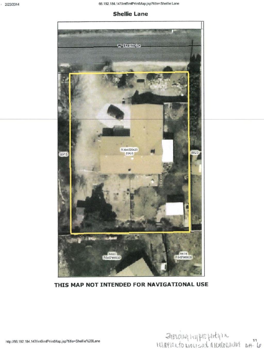
6 Development Services Department Project/File: Lead Agency: Site address: Breckenwood Subdivision The applicant is requesting Preliminary Plat and Planned Unit Development approvals for a community of 6 four-plexes on 2.26 acres. City of Boise 1906 N. Maple Grove Rd. Commission Approval: March 26, 2014 Applicant: Dave Scaggs Breckenwood, LLC S. Spring Valley Dr. Nampa, ID Representative: Steve Arnold A Team Land Consultants 1785 S. Whisper Cove Ave. Boise, ID Staff Contact: A. Findings of Fact Lauren Watsek Phone: lwatsek@achdidaho.org 1. Description of Application: The applicant is requesting preliminary plat and planned unit development approvals to develop a community of 6 four-plexes and keep the existing residence which is to be renovated and sold. The 2.26 acre property is currently zoned R-1C. 2. Description of Adjacent Surrounding Area: Direction Land Use Zoning North Residential District R-1C South Residential District R-1C East Residential District R-1C West Residential District R-1C 3. Site History: ACHD has not previously reviewed this site for a development application. 4. Transit: There is a ValleyRide bus stop located at the intersection of Shellie Lane and Maple Grove Road, at the southwest corner of the site. 5. Impact Fees: There will be an impact fee that is assessed and due prior to issuance of any building permits. The assessed impact fee will be based on the impact fee ordinance that is in effect at that time. 1 Breckenwood
7 6. Capital Improvements Plan (CIP)/ Integrated Five Year Work Plan (IFYWP): Maple Grove Road is scheduled in the Integrated Five Year Work Plan to have curb, gutter and 5 foot wide sidewalk on the west side of the street from Garverdale to Sunflower, and on the east side of the street from Mapleview to Springhurst, constructed in Maple Grove Road is listed in the Capital Improvements Plan to be widened to 5 lanes from Fairview Avenue to Ustick Road between 2017 and Fairview Avenue is listed in the Capital Improvements Plan to be widened to 7 lanes from Five Mile road to Maple Grove Road between 2027 and Fairview Avenue is listed in the Capital Improvements Plan to be widened to 7 lanes from Maple Grove Road to Cole Road between 2022 and B. Traffic Findings for Consideration 1. Trip Generation: This development is estimated to generate 209 additional vehicle trips per day (10 existing); 19 additional vehicle trips per hour in the PM peak hour (1 existing), based on the Institute of Transportation Engineers Trip Generation Manual, 9 th edition. 2. Condition of Area Roadways Traffic Count is based on Vehicles per hour (VPH) Roadway Maple Grove Road Frontage Functional Classification PM Peak Hour Traffic Count PM Peak Hour Level of Service Existing Plus Project 321 feet Minor Arterial 995 F F Shellie Lane 318 feet Local 18 N/A N/A * Acceptable level of service for a three-lane minor arterial is D (720 VPH) * Level of service E is 880 VPH ACHD Staff conducted a speed analysis on Shellie Lane on March 13, The average speed was 18 MPH. 3. Average Daily Traffic Count (VDT) Average daily traffic counts are based on ACHD s most current traffic counts. The average daily traffic count for Maple Grove Road north of Fairview Avenue was 16,906 on March 7, The average daily traffic count for Shellie Lane east of Maple Grove Road was 254 on March 13, C. Findings for Consideration 1. Area Roadway Level of Service As noted above Maple Grove Road exceeds the acceptable level of service (LOS) D for 3 lane minor arterial roadways. However, both Maple Grove/Fairview (LOS D ) and Maple Grove/Ustick (LOS C ) intersections are signalized and function at acceptable level of service standards. Maple Grove Road is listed in the CIP as with an existing 5 lane deficiency, and is planned for widening to 5-lanes in the future, as noted above. Typically, when a roadway or intersection is at 2 Breckenwood
8 or above an acceptable level of service staff recommends that improvements be constructed to mitigate the additional traffic to be generated by the development, or that the developer wait until ACHD makes improvements, as scheduled in the CIP or FYWP. In this case improvements would include widening Maple Grove Road to 5 lanes from Fairview Avenue to Ustick Road. However, given the size of the development (36 units), and the costs associated with widening Maple Grove Road ($5,000,000) it would be infeasible for the applicant to construct the improvements. There is a center turn lane on Maple Grove from Fairview to Ustick, including at Shellie Lane, which is the main access to the site. Because the applicant s proposal is consistent with Boise City s Comprehensive Plan, the intersections north and south of the site are signalized and function at an acceptable level of service, and the widening of Maple Grove Road is scheduled in the CIP, staff recommends a waiver of District Policy Level of Service Standards. This allows the project to move forward with the understanding that Maple Grove Road will be widened in the future, as adopted in the CIP. Additionally, pedestrian improvements on Maple Grove Road are being constructed this year. 2. Maple Grove Road a. Existing Conditions: Maple Grove Road is improved with 3 travel lanes. Vertical curb, gutter and 5 foot wide attached sidewalk is currently being constructed on Maple Grove Road abutting the site as part of a Community Program project. There is 58 feet of right-of-way for Maple Grove Road. b. Policy: Arterial Roadway Policy: District Policy states that the developer is responsible for improving all street frontages adjacent to the site regardless of whether or not access is taken to all of the adjacent streets. Master Street Map and Typology Policy: District Policy states that the design of improvements for arterials shall be in accordance with District standards, including the Master Street Map and Livable Streets Design Guide. The developer or engineer should contact the District before starting any design. ACHD Master Street Map: ACHD Policy Section requires the Master Street Map (MSM) guide the right-of-way acquisition, arterial street requirements, and specific roadway features required through development. This segment of Maple Grove Road is designated in the MSM as a Neighborhood Residential Arterial with 5 lanes and on-street bike lanes, a 72 foot street section within 96 feet of right-of-way. Street Section and Right-of-Way Width Policy: District Policies & state that the standard 5-lane street section shall be 72-feet (back-of-curb to back-of-curb) within 96-feet of right-of-way. This width typically accommodates two travel lanes in each direction, a continuous center left-turn lane, and bike lanes on a minor arterial and a safety shoulder on a principal arterial. Right-of-Way Dedication: District Policy states that The District will provide compensation for additional right-of-way dedicated beyond the existing right-of-way along arterials listed as impact fee eligible in the adopted Capital Improvements Plan using available impact fee revenue in the Impact Fee Service Area. No compensation will be provided for right-of-way on an arterial that is not listed as impact fee eligible in the Capital Improvements Plan. The District may acquire additional right-of-way beyond the site-related needs to preserve a corridor for future capacity improvements, as provided in Section Breckenwood
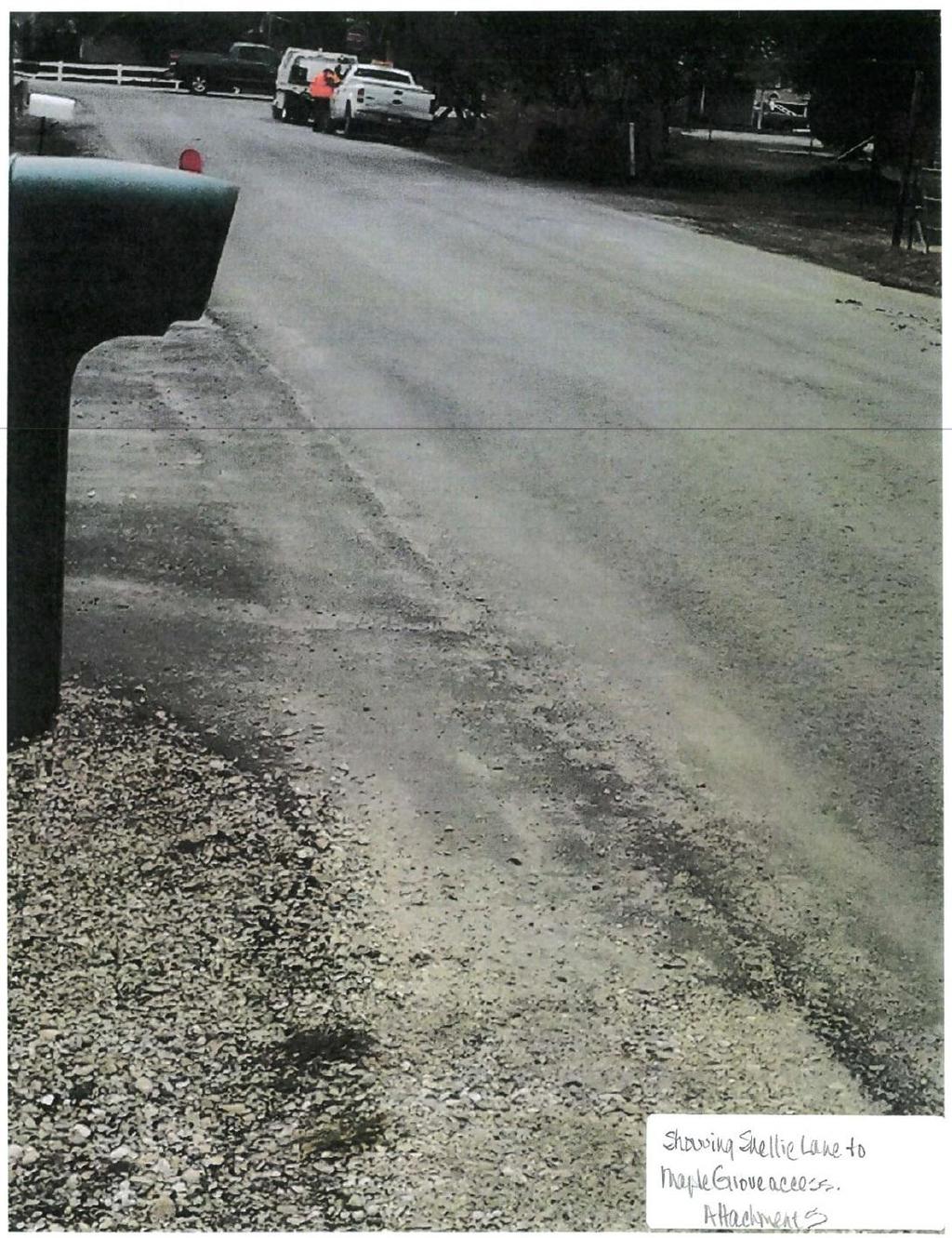
9 c. Applicant Proposal: The applicant is proposing to dedicate 48 feet of right-of-way from the centerline and construct 5 foot wide meandering concrete sidewalk on Maple Grove Road abutting the site. d. Staff Comments/Recommendations: The applicant s proposal to dedicate 48 feet of right-ofway from centerline and construct 5 foot wide meandering concrete sidewalk on Maple Grove Road abutting the site meets District Policy and should be approved as proposed. As Maple Grove Road is listed in the Capital Improvements Plan, the District will provide compensation for additional right-of-way dedicated beyond the existing right-of-way line. The applicant is not required to construct sidewalk as proposed, since sidewalk construction is currently scheduled to be completed by June 2014 funded through ACHD Community Projects. 3. Shellie Lane a. Existing Conditions: Shellie Lane is improved with 23 feet of pavement, and no curb, gutter or sidewalk abutting the site. There is 40 feet of right-of-way for Shellie Lane (20 feet from centerline). b. Policy: Local Roadway Policy: District Policy states that the developer is responsible for improving all local street frontages adjacent to the site regardless of whether or not access is taken to all of the adjacent streets. Street Section and Right-of-Way Policy: District Policy states that right-of-way widths for all local streets shall generally not be less than 50-feet wide and that the standard street section shall be 36-feet (back-of-curb to back-of-curb). The District will consider the utilization of a street width less than 36-feet with written fire department approval. Sidewalk Policy: District Policy states that five-foot wide concrete sidewalk is required on both sides of all local street, except those in rural developments with net densities of one dwelling unit per 1.0 acre or less, or in hillside conditions where there is no direct lot frontage, in which case a sidewalk shall be constructed along one side of the street. Some local jurisdictions may require wider sidewalks. The sidewalk may be placed next to the back-of-curb. Where feasible, a parkway strip at least 8-feet wide between the back-of-curb and the street edge of the sidewalk is recommended to provide increased safety and protection of pedestrians and to allow for the planting of trees in accordance with the District s Tree Planting Policy. If no trees are to be planted in the parkway strip, the applicant may submit a request to the District, with justification, to reduce the width of the parkway strip. Detached sidewalks are encouraged and should be parallel to the adjacent roadway. Meandering sidewalks are discouraged. A permanent right-of-way easement shall be provided if public sidewalks are placed outside of the dedicated right-of-way. The easement shall encompass the entire area between the rightof-way line and 2-feet behind the back edge of the sidewalk. Sidewalks shall either be located wholly within the public right-of-way or wholly within an easement. Half Street Policy: District Policy required improvements shall consist of pavement widening to one-half the required width, including curb, gutter and concrete sidewalk (minimum 5-feet), plus 12-feet of additional pavement widening beyond the centerline established for the street to provide an adequate roadway surface, with the pavement crowned at the ultimate centerline. A 3-foot wide gravel shoulder and a borrow ditch sized to accommodate the roadway storm runoff shall be constructed on the unimproved side. 4 Breckenwood
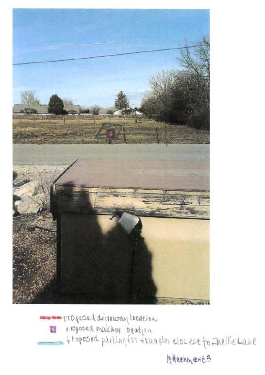
10 c. Applicant s Proposal: The applicant is proposing to dedicate an additional 5 feet of right-ofway and construct Shellie Lane as a 36 foot street section with curb, gutter and 5 foot sidewalk abutting the site. d. Staff Comments/Recommendations: The applicant s proposal to dedicate an additional 5 feet of right-of-way for Shellie Lane meets District Policy and should be approved as proposed. The applicant should be required to construct Shellie Lane as ½ of a 36 foot street section from the ultimate centerline with curb, gutter, and 5 foot wide sidewalk abutting the site. The applicant should be required to provide a permanent right-of-way easement for public sidewalks placed outside of the dedicated right-of-way. The easement shall encompass the entire area between the right-of-way line and 2 feet behind the back edge of the sidewalk. 4. Driveways 3.1 Shellie Lane a. Existing Conditions: There is one existing 20 foot wide driveway from the site onto Maple Grove Road located approximately 75 feet north of Shellie Lane and one existing unpaved driveway from the site onto Shellie Lane approximately 180 feet east of Maple Grove Road. b. Policy: Driveway Location Policy: District policy requires driveways located near intersections to be located a minimum of 75-feet (measured centerline-to-centerline) from the nearest street intersection. Successive Driveways: District Policy states that successive driveways away from an intersection shall have no minimum spacing requirements for access points along a local street, but the District does encourage shared access points where appropriate. Driveway Width Policy: District policy states that where vertical curbs are required, residential driveways shall be restricted to a maximum width of 20-feet and may be constructed as curb-cut type driveways. Driveway Paving Policy: Graveled driveways abutting public streets create maintenance problems due to gravel being tracked onto the roadway. In accordance with District policy, , the applicant should be required to pave the driveway its full width and at least 30-feet into the site beyond the edge of pavement of the roadway. c. Applicant s Proposal: The applicant is proposing to remove both existing driveways and construct one private drive aisle to serve the 6 four-plexes, and one new private driveway to serve the existing home onto Shellie Lane. The applicant is proposing to construct the new private driveway to serve the existing residence to be approximately 14 feet wide and located approximately 130 feet east of Maple Grove Road. The applicant is proposing to construct the private drive aisle to serve the four-plex community to be approximately 23 feet wide and located approximately 310 feet east of Maple Grove Road. d. Staff Comments/Recommendations: The applicant s proposal to close both existing driveways and construct one private driveway to serve the existing home and one private drive aisle to serve the four-plex community on to Shellie Lane meets District Policy and should be approved as proposed. The applicant should be required to pave both of the proposed private drives their entire widths and at least 30 feet into the site beyond the edge of pavement of Shellie Lane. District policy does not allow access to a minor arterial (Maple Grove Road) when there is frontage on a lesser classified road (Shellie Lane). 5. Private Roads a. Private Road Policy: District policy states that the lead land use agencies in Ada County establish the requirements for private streets. The District retains authority and will 5 Breckenwood
11 review the proposed intersection of a private and public street for compliance with District intersection policies and standards. The private road should have the following requirements: Designed to discourage through traffic between two public streets, Graded to drain away from the public street intersection, and If a private road is gated, the gate or keypad (if applicable) shall be located a minimum of 50-feet from the near edge of the intersection and a turnaround shall be provided. b. Staff Comments/Recommendations: If the City of Boise approves the private road, the applicant shall be required to pave the private roadway a minimum of 20 to 24-feet wide and at least 30-feet into the site beyond the edge of pavement of all public streets and install pavement tapers with 15-foot curb radii abutting the existing roadway edge. If private roads are not approved by the City of Boise, the applicant will be required to revise and resubmit the preliminary plat to provide public standard local streets in these locations. Street name and stop signs are required for the private road. The signs may be ordered through the District. Verification of the correct, approved name of the road is required. ACHD does not make any assurances that the private road, which is a part of this application, will be accepted as a public road if such a request is made in the future. Substantial redesign and reconstruction costs may be necessary in order to qualify this road for public ownership and maintenance. The following requirements must be met if the applicant wishes to dedicate the roadway to ACHD: Dedicate a minimum of 50-feet of right-of-way for the road. Construct the roadway to the minimum ACHD requirements. Construct a stub street to the surrounding parcels. 6. Tree Planters Tree Planter Policy: Tree Planter Policy: The District s Tree Planter Policy prohibits all trees in planters less than 8-feet in width without the installation of root barriers. Class II trees may be allowed in planters with a minimum width of 8-feet, and Class I and Class III trees may be allowed in planters with a minimum width of 10-feet. 7. Landscaping Landscaping Policy: A license agreement is required for all landscaping proposed within ACHD right-of-way or easement areas. Trees shall be located no closer than 10-feet from all public storm drain facilities. Landscaping should be designed to eliminate site obstructions in the vision triangle at intersections. District Policy requires a 40-foot vision triangle and a 3-foot height restriction on all landscaping located at an uncontrolled intersection and a 50-foot offset from stop signs. Landscape plans are required with the submittal of civil plans and must meet all District requirements prior to signature of the final plat and/or approval of the civil plans. 8. Other Access Maple Grove Road is classified as a minor arterial roadway. Direct lot access is prohibited to this roadway and should be noted on the final plat. 6 Breckenwood
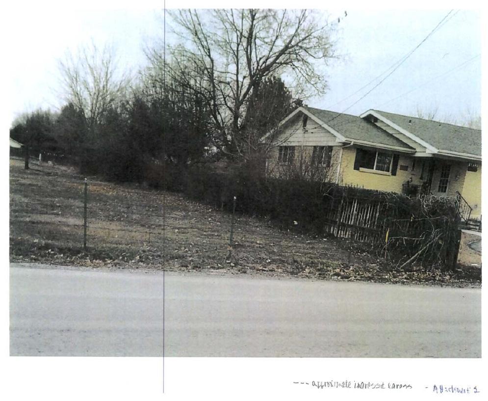
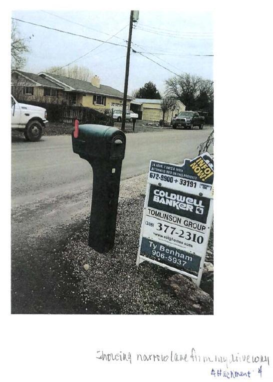
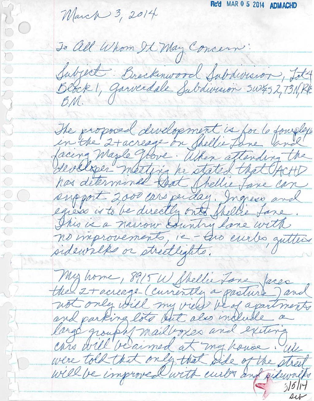
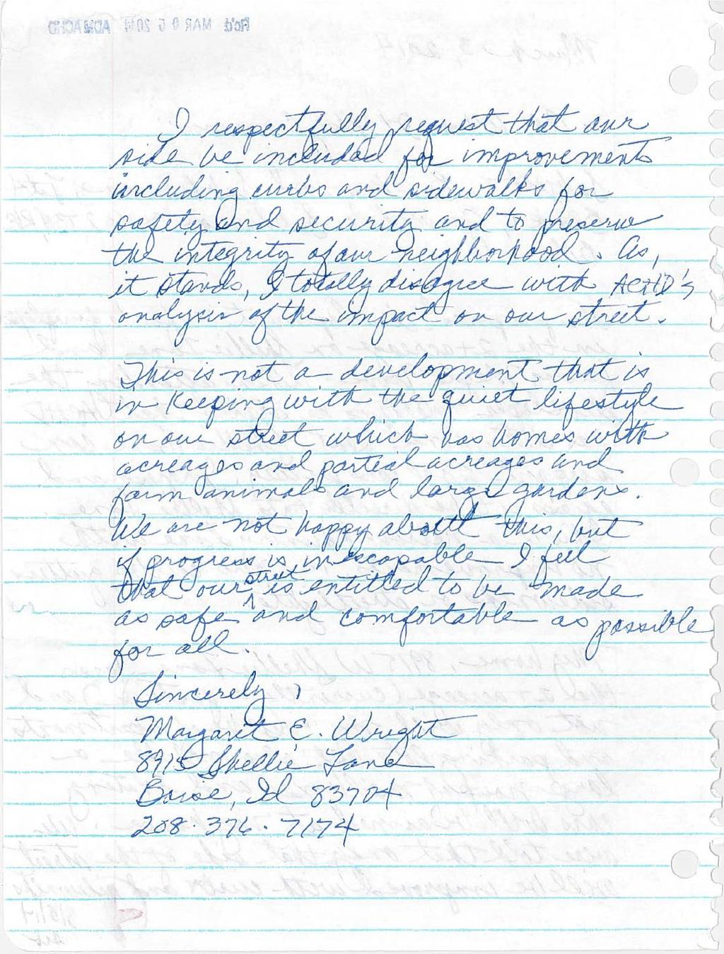
12 9. Neighborhood Concerns This application is on the regular agenda due to neighborhood concerns. Correspondence that has been received prior to March 14, 2014 is included with this staff report. Neighborhood concerns include: Access on to Shellie Lane o Concern: Residents are concerned about the additional traffic on Shellie Lane. o Proposal: The applicant proposed access to Shellie Lane, in accordance with ACHD Policy. o Staff comment: The total traffic projected to be generated from this development is 209 VTD, and 19 trips in the PM peak hour. ACHD conducted a traffic count on March 13, There were 131 daily vehicle trips and 18 vehicle trips in the peak hour. The standard threshold for local streets is 2,000 VTD. Street Improvements on Shellie Lane o Concern: Residents are concerned about the lack of street improvements on both sides of Shellie Lane. o Proposal: The applicant is proposing to construct Shellie Lane as ½ of a 36 foot street section with curb, gutter, and 5 foot wide concrete sidewalk abutting the site, in accordance with ACHD policy. o Staff comment: ACHD policy requires the developer to improve the portion of Shellie Lane abutting the proposed site only. Through ACHD s Community Programs, Shellie Lane could be a possible candidate for further street improvements. D. Site Specific Conditions of Approval 1. Dedicate 48 feet of right-of-way from centerline for Maple Grove Road abutting the site as proposed. The District will provide compensation for additional right-of-way dedicated beyond the existing right-of-way line. 2. Dedicate an additional 5 feet of right-of-way for Shellie Lane abutting the site as proposed. Construct Shellie Lane as ½ of a 36 foot street section from the ultimate centerline with curb, gutter, and 5 foot wide sidewalk abutting the site. Provide a permanent right-of-way easement for sidewalks placed outside of the dedicated right-of-way. 3. Close the existing driveways onto Maple Grove Road and Shellie Lane as proposed. 4. Construct one private driveway onto Shellie Lane to serve the existing home, located approximately 130 feet east of Maple Grove Road as proposed. 5. Construct one 23 foot wide private drive aisle on to Shellie Lane to serve the proposed four-plex community located approximately 310 feet east of Maple Grove Road as proposed. 6. Pave both driveways their full widths and at least 30 feet into the site beyond the edge of pavement of Shellie Lane. 7. Direct lot access to Maple Grove Road is prohibited and shall be noted on the final plat. 8. Payment of impacts fees are due prior to issuance of a building permit. 9. Comply with all Standard Conditions of Approval. 7 Breckenwood
13 E. Standard Conditions of Approval 1. All irrigation facilities shall be relocated outside of the ACHD right-of-way. 2. Private Utilities including sewer or water systems are prohibited from being located within the ACHD right-of-way. 3. In accordance with District policy, , the applicant may be required to update any existing non-compliant pedestrian improvements abutting the site to meet current Americans with Disabilities Act (ADA) requirements. The applicant s engineer should provide documentation of ADA compliance to District Development Review staff for review. 4. Replace any existing damaged curb, gutter and sidewalk and any that may be damaged during the construction of the proposed development. Contact Construction Services at (with file number) for details. 5. A license agreement and compliance with the District s Tree Planter policy is required for all landscaping proposed within ACHD right-of-way or easement areas. 6. All utility relocation costs associated with improving street frontages abutting the site shall be borne by the developer. 7. It is the responsibility of the applicant to verify all existing utilities within the right-of-way. The applicant at no cost to ACHD shall repair existing utilities damaged by the applicant. The applicant shall be required to call DIGLINE ( ) at least two full business days prior to breaking ground within ACHD right-of-way. The applicant shall contact ACHD Traffic Operations in the event any ACHD conduits (spare or filled) are compromised during any phase of construction. 8. Utility street cuts in pavement less than five years old are not allowed unless approved in writing by the District. Contact the District s Utility Coordinator at (with file numbers) for details. 9. All design and construction shall be in accordance with the ACHD Policy Manual, ISPWC Standards and approved supplements, Construction Services procedures and all applicable ACHD Standards unless specifically waived herein. An engineer registered in the State of Idaho shall prepare and certify all improvement plans. 10. Construction, use and property development shall be in conformance with all applicable requirements of ACHD prior to District approval for occupancy. 11. No change in the terms and conditions of this approval shall be valid unless they are in writing and signed by the applicant or the applicant s authorized representative and an authorized representative of ACHD. The burden shall be upon the applicant to obtain written confirmation of any change from ACHD. 12. If the site plan or use should change in the future, ACHD Planning Review will review the site plan and may require additional improvements to the transportation system at that time. Any change in the planned use of the property which is the subject of this application, shall require the applicant to comply with ACHD Policy and Standard Conditions of Approval in place at that time unless a waiver/variance of the requirements or other legal relief is granted by the ACHD Commission. F. Conclusions of Law 1. The proposed site plan is approved, if all of the Site Specific and Standard Conditions of Approval are satisfied. 2. ACHD requirements are intended to assure that the proposed use/development will not place an undue burden on the existing vehicular transportation system within the vicinity impacted by the proposed development. 8 Breckenwood
14 G. Attachments 1. Vicinity Map 2. Site Plan 3. Neighborhood Correspondence 4. Utility Coordinating Council 5. Development Process Checklist 6. Request for Reconsideration Guidelines 9 Breckenwood
15 VICINITY MAP 10 Breckenwood

16 SITE PLAN 11 Breckenwood
17 NEIGHBORHOOD CORRESPONDENCE 12 Breckenwood
18 13 Breckenwood
19 14 Breckenwood
20 15 Breckenwood
21 16 Breckenwood
22 17 Breckenwood
23 18 Breckenwood
24 19 Breckenwood
25 20 Breckenwood
26 21 Breckenwood
27 Ada County Utility Coordinating Council Developer/Local Improvement District Right of Way Improvements Guideline Request Purpose: To develop the necessary avenue for proper notification to utilities of local highway and road improvements, to help the utilities in budgeting and to clarify the already existing process. 1) Notification: Within five (5) working days upon notification of required right of way improvements by Highway entities, developers shall provide written notification to the affected utility owners and the Ada County Utility Coordinating Council (UCC). Notification shall include but not be limited to, project limits, scope of roadway improvements/project, anticipated construction dates, and any portions critical to the right of way improvements and coordination of utilities. 2) Plan Review: The developer shall provide the highway entities and all utility owners with preliminary project plans and schedule a plan review conference. Depending on the scale of utility improvements, a plan review conference may not be necessary, as determined by the utility owners. Conference notification shall also be sent to the UCC. During the review meeting the developer shall notify utilities of the status of right of way/easement acquisition necessary for their project. At the plan review conference each company shall have the right to appeal, adjust and/or negotiate with the developer on its own behalf. Each utility shall provide the developer with a letter of review indicating the costs and time required for relocation of its facilities. Said letter of review is to be provided within thirty calendar days after the date of the plan review conference. 3) Revisions: The developer is responsible to provide utilities with any revisions to preliminary plans. Utilities may request an updated plan review meeting if revisions are made in the preliminary plans which affect the utility relocation requirements. Utilities shall have thirty days after receiving the revisions to review and comment thereon. 4) Final Notification: The developer will provide highway entities, utility owners and the UCC with final notification of its intent to proceed with right of way improvements and include the anticipated date work will commence. This notification shall indicate that the work to be performed shall be pursuant to final approved plans by the highway entity. The developer shall schedule a preconstruction meeting prior to right of way improvements. Utility relocation activity shall be completed within the times established during the preconstruction meeting, unless otherwise agreed upon. Notification to the Ada County UCC can be sent to: 50 S. Cole Rd. Boise 83707, or Visit iducc.com for notification information. 22 Breckenwood
28 Items Completed to Date: Development Process Checklist Submit a development application to a City or to Ada County The City or the County will transmit the development application to ACHD The ACHD Planning Review Section will receive the development application to review The Planning Review Section will do one of the following: Send a No Review letter to the applicant stating that there are no site specific conditions of approval at this time. Write a Staff Level report analyzing the impacts of the development on the transportation system and evaluating the proposal for its conformance to District Policy. Write a Commission Level report analyzing the impacts of the development on the transportation system and evaluating the proposal for its conformance to District Policy. Items to be completed by Applicant: For ALL development applications, including those receiving a No Review letter: The applicant should submit one set of engineered plans directly to ACHD for review by the Development Review Section for plan review and assessment of impact fees. (Note: if there are no site improvements required by ACHD, then architectural plans may be submitted for purposes of impact fee assessment.) The applicant is required to get a permit from Construction Services (ACHD) for ANY work in the right-ofway, including, but not limited to, driveway approaches, street improvements and utility cuts. Pay Impact Fees prior to issuance of building permit. Impact fees cannot be paid prior to plan review approval. DID YOU REMEMBER: Construction (Non-Subdivisions) Driveway or Property Approach(s) Submit a Driveway Approach Request form to ACHD Construction (for approval by Development Services & Traffic Services). There is a one week turnaround for this approval. Working in the ACHD Right-of-Way Four business days prior to starting work have a bonded contractor submit a Temporary Highway Use Permit Application to ACHD Construction Permits along with: a) Traffic Control Plan b) An Erosion & Sediment Control Narrative & Plat, done by a Certified Plan Designer, if trench is >50 or you are placing >600 sf of concrete or asphalt. Construction (Subdivisions) Sediment & Erosion Submittal At least one week prior to setting up a Pre-Construction Meeting an Erosion & Sediment Control Narrative & Plan, done by a Certified Plan Designer, must be turned into ACHD Construction to be reviewed and approved by the ACHD Stormwater Section. Idaho Power Company Vic Steelman at Idaho Power must have his IPCO approved set of subdivision utility plans prior to Pre-Con being scheduled. Final Approval from Development Services is required prior to scheduling a Pre-Con. 23 Breckenwood
29 Request for Appeal of Staff Decision 1. Appeal of Staff Decision: The Commission shall hear and decide appeals by an applicant of the final decision made by the ROWDS Manager when it is alleged that the ROWDS Manager did not properly apply this section , did not consider all of the relevant facts presented, made an error of fact or law, abused discretion or acted arbitrarily and capriciously in the interpretation or enforcement of the ACHD Policy Manual. a. Filing Fee: The Commission may, from time to time, set reasonable fees to be charged the applicant for the processing of appeals, to cover administrative costs. b. Initiation: An appeal is initiated by the filing of a written notice of appeal with the Secretary of Highway Systems, which must be filed within ten (10) working days from the date of the decision that is the subject of the appeal. The notice of appeal shall refer to the decision being appealed, identify the appellant by name, address and telephone number and state the grounds for the appeal. The grounds shall include a written summary of the provisions of the policy relevant to the appeal and/or the facts and law relied upon and shall include a written argument in support of the appeal. The Commission shall not consider a notice of appeal that does not comply with the provisions of this subsection. c. Time to Reply: The ROWDS Manager shall have ten (10) working days from the date of the filing of the notice of appeal to reply to the notice of the appeal, and may during such time meet with the appellant to discuss the matter, and may also consider and/or modify the decision that is being appealed. A copy of the reply and any modifications to the decision being appealed will be provided to the appellant prior to the Commission hearing on the appeal. d. Notice of Hearing: Unless otherwise agreed to by the appellant, the hearing of the appeal will be noticed and scheduled on the Commission agenda at a regular meeting to be held within thirty (30) days following the delivery to the appellant of the ROWDS Manager s reply to the notice of appeal. A copy of the decision being appealed, the notice of appeal and the reply shall be delivered to the Commission at least one (1) week prior to the hearing. e. Action by Commission: Following the hearing, the Commission shall either affirm or reverse, in whole or part, or otherwise modify, amend or supplement the decision being appealed, as such action is adequately supported by the law and evidence presented at the hearing. 24 Breckenwood
30 Request for Reconsideration of Commission Action 1. Request for Reconsideration of Commission Action: A Commissioner, a member of ACHD staff or any other person objecting to any final action taken by the Commission may request reconsideration of that action, provided the request is not for a reconsideration of an action previously requested to be reconsidered, an action whose provisions have been partly and materially carried out, or an action that has created a contractual relationship with third parties. a. Only a Commission member who voted with the prevailing side can move for reconsideration, but the motion may be seconded by any Commissioner and is voted on by all Commissioners present. If a motion to reconsider is made and seconded it is subject to a motion to postpone to a certain time. b. The request must be in writing and delivered to the Secretary of the Highway District no later than 3:00 p.m. on the day prior to the Commission s next scheduled regular meeting following the meeting at which the action to be reconsidered was taken. Upon receipt of the request, the Secretary shall cause the same to be placed on the agenda for that next scheduled regular Commission meeting. c. The request for reconsideration must be supported by written documentation setting forth new facts and information not presented at the earlier meeting, or a changed situation that has developed since the taking of the earlier vote, or information establishing an error of fact or law in the earlier action. The request may also be supported by oral testimony at the meeting. d. If a motion to reconsider passes, the effect is the original matter is in the exact position it occupied the moment before it was voted on originally. It will normally be returned to ACHD staff for further review. The Commission may set the date of the meeting at which the matter is to be returned. The Commission shall only take action on the original matter at a meeting where the agenda notice so provides. e. At the meeting where the original matter is again on the agenda for Commission action, interested persons and ACHD staff may present such written and oral testimony as the President of the Commission determines to be appropriate, and the Commission may take any action the majority of the Commission deems advisable. f. If a motion to reconsider passes, the applicant may be charged a reasonable fee, to cover administrative costs, as established by the Commission. 25 Breckenwood

31 Development Services Department Project/File: Lead Agency: Site address: Breckenwood #2 / BPP / SUB / PUD The applicant is requesting preliminary plat and planned unit development approval for Breckenwood #2 Subdivision. City of Boise 8822 W. Shellie Ln. Staff Approval: August 15, 2014 Applicant: Staff Contact: Steve Arnold A Team Land Consultants 1785 S. Whisper Cove Ave. Boise, ID Austin Miller Phone: amiller@achdidaho.org A. Findings of Fact 1. Description of Application: The applicant is requesting preliminary plat and planned unit development approval for Breckenwood #2, a residential development consisting of three 4-plex buildings on 1.36 acres. The lot is currently occupied by one single family home, which is proposed to remain. The property is currently zoned R-1C and the proposal is consistent with the City of Boise s comprehensive plan. 2. Description of Adjacent Surrounding Area: Direction Land Use Zoning North Residential District R-1C South Residential District R-1C East Residential District R-1C West Residential District R-1C 3. Site History: ACHD has not previously reviewed this site for a development application. 4. Adjacent Development: The following developments are pending or underway in the vicinity of the site: Breckenwood Subdivision, a residential community consisting of six 4-plex buildings, is adjacent to the west side of this site, and received ACHD Commission approval on March 26, Transit: A ValleyRide bus stop is located at the intersection of Shellie Lane and Maple Grove Road. 1 Breckenwood #2
32 6. New Center Lane Miles: This development does not include new public road. 7. Impact Fees: There will be an impact fee that is assessed and due prior to issuance of any building permits. The assessed impact fee will be based on the impact fee ordinance that is in effect at that time. 8. Capital Improvements Plan (CIP)/ Integrated Five Year Work Plan (IFYWP): Maple Grove Road is scheduled in the Integrated Five Year Work Plan to have curb, gutter and 5 foot wide sidewalk on the west side of the street from Garverdale to Sunflower, and on the east side of the street from Mapleview to Springhurst, constructed in Maple Grove Road is listed in the Capital Improvements Plan to be widened to 5 lanes from Fairview Avenue to Ustick Road between 2017 and Fairview Avenue is listed in the Capital Improvements Plan to be widened to 7 lanes from Five Mile road to Maple Grove Road between 2027 and Fairview Avenue is listed in the Capital Improvements Plan to be widened to 7 lanes from Maple Grove Road to Cole Road between 2022 and B. Traffic Findings for Consideration 1. Trip Generation: This development is estimated to generate 80 additional vehicle trips per day (10 existing); 7 additional vehicle trips per hour in the PM peak hour (1 existing), based on the Institute of Transportation Engineers Trip Generation Manual, 9 th edition. 2. Condition of Area Roadways Traffic Count is based on Vehicles per hour (VPH) Roadway Maple Grove Road * Acceptable level of service for a three-lane minor arterial is D (720 VPH) * Level of service E is 880 VPH ACHD Staff conducted a speed analysis on Shellie Lane on March 13, The average speed was 18 MPH. 3. Average Daily Traffic Count (VDT) Average daily traffic counts are based on ACHD s most current traffic counts. Frontage Functional Classification The average daily traffic count for Maple Grove Road north of Fairview Avenue was 16,906 on March 7, The average daily traffic count for Shellie Lane east of Maple Grove Road was 254 on March 13, C. Findings for Consideration 1. Area Roadway Level of Service PM Peak Hour Traffic Count PM Peak Hour Level of Service Existing Plus Project None Minor Arterial 995 F F Shellie Lane 190 feet Local 18 N/A N/A As noted above Maple Grove Road exceeds the acceptable level of service (LOS) D for 3 lane minor arterial roadways. However, both Maple Grove/Fairview (LOS D ) and Maple Grove/Ustick (LOS C ) intersections are signalized and function at acceptable level of service standards. 2 Breckenwood #2
33 Maple Grove Road is listed in the CIP as with an existing 5 lane deficiency, and is planned for widening to 5-lanes in the future, as noted above. Typically, when a roadway or intersection is at or above an acceptable level of service staff recommends that improvements be constructed to mitigate the additional traffic to be generated by the development, or that the developer wait until ACHD makes improvements, as scheduled in the CIP or FYWP. In this case improvements would include widening Maple Grove Road to 5 lanes from Fairview Avenue to Ustick Road. However, given the size of the development (36 units), and the costs associated with widening Maple Grove Road ($5,000,000) it would be infeasible for the applicant to construct the improvements. There is a center turn lane on Maple Grove from Fairview to Ustick, including at Shellie Lane, which is the main access to the site. Because the applicant s proposal is consistent with Boise City s Comprehensive Plan, the intersections north and south of the site are signalized and function at an acceptable level of service, and the widening of Maple Grove Road is scheduled in the CIP, staff recommends approval. Additionally, pedestrian improvements on Maple Grove Road are being constructed this year. 2. Shellie Lane a. Existing Conditions: Shellie Lane is improved with 23 feet of pavement, and no curb, gutter or sidewalk abutting the site. There is 40 feet of right-of-way for Shellie Lane (20 feet from centerline). b. Policy: Local Roadway Policy: District Policy states that the developer is responsible for improving all local street frontages adjacent to the site regardless of whether or not access is taken to all of the adjacent streets. Street Section and Right-of-Way Policy: District Policy states that right-of-way widths for all local streets shall generally not be less than 50-feet wide and that the standard street section shall be 36-feet (back-of-curb to back-of-curb). The District will consider the utilization of a street width less than 36-feet with written fire department approval. Sidewalk Policy: District Policy states that five-foot wide concrete sidewalk is required on both sides of all local street, except those in rural developments with net densities of one dwelling unit per 1.0 acre or less, or in hillside conditions where there is no direct lot frontage, in which case a sidewalk shall be constructed along one side of the street. Some local jurisdictions may require wider sidewalks. The sidewalk may be placed next to the back-of-curb. Where feasible, a parkway strip at least 8-feet wide between the back-of-curb and the street edge of the sidewalk is recommended to provide increased safety and protection of pedestrians and to allow for the planting of trees in accordance with the District s Tree Planting Policy. If no trees are to be planted in the parkway strip, the applicant may submit a request to the District, with justification, to reduce the width of the parkway strip. Detached sidewalks are encouraged and should be parallel to the adjacent roadway. Meandering sidewalks are discouraged. A permanent right-of-way easement shall be provided if public sidewalks are placed outside of the dedicated right-of-way. The easement shall encompass the entire area between the rightof-way line and 2-feet behind the back edge of the sidewalk. Sidewalks shall either be located wholly within the public right-of-way or wholly within an easement. Half Street Policy: District Policy required improvements shall consist of pavement widening to one-half the required width, including curb, gutter and concrete sidewalk (minimum 5-feet), plus 12-feet of additional pavement widening beyond the centerline 3 Breckenwood #2
34 established for the street to provide an adequate roadway surface, with the pavement crowned at the ultimate centerline. A 3-foot wide gravel shoulder and a borrow ditch sized to accommodate the roadway storm runoff shall be constructed on the unimproved side. c. Applicant s Proposal: The applicant is proposing to dedicate an additional 5 feet of right-ofway and construct Shellie Lane as a 36 foot street section with curb, gutter and 5 foot wide detached concrete sidewalk abutting the site. d. Staff Comments/Recommendations: The applicant s proposal to dedicate an additional 5 feet of right-of-way for Shellie Lane meets District Policy and should be approved as proposed. The applicant should be required to construct Shellie Lane as ½ of a 36 foot street section from the ultimate centerline with curb, gutter, and 5 foot wide detached meandering sidewalk abutting the site. Staff recommends 5 foot wide attached concrete sidewalk in lieu of the proposed detached meandering sidewalk. The attached sidewalk will be consistent with the development to the west and will provide more visibility for pedestrians. The applicant should be required to provide a permanent right-of-way easement for public sidewalks placed outside of the dedicated right-of-way. The easement shall encompass the entire area between the right-of-way line and 2 feet behind the back edge of the sidewalk. 3. Driveways 3.1 Shellie Lane a. Existing Conditions: There are 2 existing driveways from the site onto Shellie Lane. One 17- foot wide driveway is located 23 feet from the western property line (measured from the centerline). The other driveway is approximately 37 feet wide and located 80 feet from the western property line (measured from the centerline). b. Policy: Driveway Location Policy: District policy requires driveways located near intersections to be located a minimum of 75-feet (measured centerline-to-centerline) from the nearest street intersection. Successive Driveways: District Policy states that successive driveways away from an intersection shall have no minimum spacing requirements for access points along a local street, but the District does encourage shared access points where appropriate. Driveway Width Policy: District policy states that where vertical curbs are required, residential driveways shall be restricted to a maximum width of 20-feet and may be constructed as curb-cut type driveways. Driveway Paving Policy: Graveled driveways abutting public streets create maintenance problems due to gravel being tracked onto the roadway. In accordance with District policy, , the applicant should be required to pave the driveway its full width and at least 30-feet into the site beyond the edge of pavement of the roadway. c. Applicant s Proposal: The applicant is proposing to continue use of the existing driveways to serve the existing residence. The applicant is also proposing to construct one additional driveway to serve one of the new lots. A cross-access easement is proposed, allowing private road access to the site from Breckenwood Subdivision. d. Staff Comments/Recommendations: The applicant s proposal to utilize the existing driveways and construct one additional driveway onto Shellie Lane meets District Policy and should be approved as proposed. The applicant should be required to pave the new driveway its entire width and at least 30 feet into the site beyond the edge of pavement of Shellie Lane. 4. Tree Planters 4 Breckenwood #2
35 Tree Planter Policy: Tree Planter Policy: The District s Tree Planter Policy prohibits all trees in planters less than 8-feet in width without the installation of root barriers. Class II trees may be allowed in planters with a minimum width of 8-feet, and Class I and Class III trees may be allowed in planters with a minimum width of 10-feet. 5. Landscaping Landscaping Policy: A license agreement is required for all landscaping proposed within ACHD right-of-way or easement areas. Trees shall be located no closer than 10-feet from all public storm drain facilities. Landscaping should be designed to eliminate site obstructions in the vision triangle at intersections. District Policy requires a 40-foot vision triangle and a 3-foot height restriction on all landscaping located at an uncontrolled intersection and a 50-foot offset from stop signs. Landscape plans are required with the submittal of civil plans and must meet all District requirements prior to signature of the final plat and/or approval of the civil plans. D. Site Specific Conditions of Approval 1. Dedicate an additional 5 feet of right-of-way for Shellie Lane abutting the site as proposed. Construct Shellie Lane as ½ of a 36 foot street section from the ultimate centerline with curb, gutter, and 5 foot wide sidewalk abutting the site. Provide a permanent right-of-way easement for sidewalks placed outside of the dedicated right-of-way. 2. Pave the proposed driveway onto Shellie Lane its full width and at least 30 feet into the site beyond the edge of pavement of Shellie Lane. 3. There is a moratorium on Shellie Lane thru Any cuts in the pavement will need to be reviewed by the pavement cut committee. 4. Payment of impacts fees are due prior to issuance of a building permit. 5. Comply with all Standard Conditions of Approval. E. Standard Conditions of Approval 1. All proposed irrigation facilities shall be located outside of the ACHD right-of-way (including all easements). Any existing irrigation facilities shall be relocated outside of the ACHD rightof-way (including all easements). 2. Private Utilities including sewer or water systems are prohibited from being located within the ACHD right-of-way. 3. In accordance with District policy, , the applicant may be required to update any existing non-compliant pedestrian improvements abutting the site to meet current Americans with Disabilities Act (ADA) requirements. The applicant s engineer should provide documentation of ADA compliance to District Development Review staff for review. 4. Replace any existing damaged curb, gutter and sidewalk and any that may be damaged during the construction of the proposed development. Contact Construction Services at (with file number) for details. 5. A license agreement and compliance with the District s Tree Planter policy is required for all landscaping proposed within ACHD right-of-way or easement areas. 6. All utility relocation costs associated with improving street frontages abutting the site shall be borne by the developer. 7. It is the responsibility of the applicant to verify all existing utilities within the right-of-way. The applicant at no cost to ACHD shall repair existing utilities damaged by the applicant. The applicant shall be required to call DIGLINE ( ) at least two full business days prior to breaking ground within ACHD right-of-way. The applicant shall contact ACHD 5 Breckenwood #2
36 Traffic Operations in the event any ACHD conduits (spare or filled) are compromised during any phase of construction. 8. Utility street cuts in pavement less than five years old are not allowed unless approved in writing by the District. Contact the District s Utility Coordinator at (with file numbers) for details. 9. All design and construction shall be in accordance with the ACHD Policy Manual, ISPWC Standards and approved supplements, Construction Services procedures and all applicable ACHD Standards unless specifically waived herein. An engineer registered in the State of Idaho shall prepare and certify all improvement plans. 10. Construction, use and property development shall be in conformance with all applicable requirements of ACHD prior to District approval for occupancy. 11. No change in the terms and conditions of this approval shall be valid unless they are in writing and signed by the applicant or the applicant s authorized representative and an authorized representative of ACHD. The burden shall be upon the applicant to obtain written confirmation of any change from ACHD. 12. If the site plan or use should change in the future, ACHD Planning Review will review the site plan and may require additional improvements to the transportation system at that time. Any change in the planned use of the property which is the subject of this application, shall require the applicant to comply with ACHD Policy and Standard Conditions of Approval in place at that time unless a waiver/variance of the requirements or other legal relief is granted by the ACHD Commission. F. Conclusions of Law 1. The proposed site plan is approved, if all of the Site Specific and Standard Conditions of Approval are satisfied. 2. ACHD requirements are intended to assure that the proposed use/development will not place an undue burden on the existing vehicular transportation system within the vicinity impacted by the proposed development. G. Attachments 1. Vicinity Map 2. Site Plan 3. Utility Coordinating Council 4. Development Process Checklist 5. Request for Reconsideration Guidelines 6 Breckenwood #2

37 VICINITY MAP 7 Breckenwood #2
Committed to Service
 Committed to Service Paul Woods, President Rebecca W. Arnold, Vice President Sara M. Baker, Commissioner Jim D. Hansen, Commissioner Kent Goldthorpe, Commissioner August 25, 2017 Development Services TO:
Date: March 16, Jake Centers ERD, LLC P.O. Box 1610 Eagle, ID Elevation Ridge Subdivision (SUB & PUD ) Street Address
 Street Address") Rebecca W. Arnold, President Sara M. Baker, Vice President John S. Franden, Commissioner Carol A. McKee, Commissioner David L. Case, Commissioner Date: March 16, 2012 To: Jake Centers ERD, LLC P.O. Box
Rebecca W. Arnold, President Sara M. Baker, Vice President John S. Franden, Commissioner Carol A. McKee, Commissioner David L. Case, Commissioner Date: March 16, 2012 To: Jake Centers ERD, LLC P.O. Box
SUB /CAR /PUD
 Development Services Department Project/File: Lead Agency: Site address: Balntyre Court Subdivision/BPP16-0036/ SUB16-00066/CAR16-00035/PUD16-00040 This is a rezone, planned unit development, and subdivision
May 21, ACHD Board of Commissioners Stacey Yarrington, Planner II DRH /DRH
 Development Services Department May 21, 2013 TO: FROM: SUBJECT: ACHD Board of Commissioners Stacey Yarrington, Planner II DRH13-00106/DRH13-00108 Executive Summary: This is a design review application
Date: August 29, Dave Scaggs (sent via ) Summit Development Inc th Ave. Rd. #384 Nampa, ID 83686
 Summit Development Inc th Ave. Rd. #384 Nampa, ID 83686") Sara M. Baker, President John S. Franden, Vice President Rebecca W. Arnold, Commissioner Mitchell A. Jaurena, Commissioner Jim Hansen, Commissioner Date: August 29, 2013 To: Dave Scaggs (sent via email)
Sara M. Baker, President John S. Franden, Vice President Rebecca W. Arnold, Commissioner Mitchell A. Jaurena, Commissioner Jim Hansen, Commissioner Date: August 29, 2013 To: Dave Scaggs (sent via email)
Executive Summary: This is a preliminary plat to construct 8 residential lots and 2 commons lots with a private road on 3.87-acres in Meridian, Idaho.
 Development Services Department DATE: July 7, 2015 TO: FROM: SUBJECT: ACHD Board of Commissioners Stacey Yarrington, Planner III Kentucky Villas/ MPP15-0012/ PP15-009 Executive Summary: This is a preliminary
Committed to Service
 Committed to Service Kent Goldthorpe, President Paul Woods, Vice President Rebecca W. Arnold, Commissioner Sara M. Baker, Commissioner Jim D. Hansen, Commissioner July 18, 2016 Development Services TO:
If you have any questions, please feel free to contact me at (208)
") Sara M. Baker, President John S. Franden, Vice President Rebecca W. Arnold, Commissioner Mitchell A. Jaurena, Commissioner Jim Hansen, Commissioner Date: March 21, 2013 To: Subject: Hornet Construction
Sara M. Baker, President John S. Franden, Vice President Rebecca W. Arnold, Commissioner Mitchell A. Jaurena, Commissioner Jim Hansen, Commissioner Date: March 21, 2013 To: Subject: Hornet Construction
BOI / DRH Albertsons grocery market and fueling center & pad sites
 Paul Woods, President Rebecca W. Arnold, Vice President Sara M. Baker, Commissioner Jim D. Hansen, Commissioner Kent Goldthorpe, Commissioner March 28, 2017 To: Mark Palmer Albertsons Companies 250 E.
Committed to Service
 Committed to Service Sara M. Baker, President Rebecca W. Arnold, Vice President Jim D. Hansen, Commissioner Kent Goldthorpe, Commissioner Paul Woods, Commissioner January 16, 2018 Development Services
#1 (CAR /SUB )
") Development Services Department Project/File: Lead Agency: Site address: Fork South #1 (CAR14-00009/SUB14-00024) The applicant is requesting annexation, rezone and preliminary plat approvals for a 52-lot
Development Services Department Project/File: Lead Agency: Site address: Fork South #1 (CAR14-00009/SUB14-00024) The applicant is requesting annexation, rezone and preliminary plat approvals for a 52-lot
Right-of-Way & Development Services Planning Review Division Committed to Service This application is approved at the staff level on February 1, 2006.
 Right-of-Way & Development Services Planning Review Division Committed to Service This application is approved at the staff level on February 1, 2006. Tech Review for this item was held with the applicant
Committed to Service
 Development Services Department Committed to Service June 23, 2015 TO: FROM: SUBJECT: ACHD Board of Commissioners Mindy Wallace, AICP Planner III Linder Apartments - EAG15-0005/ CPA-01-15/A-01-15/RZ-04-15
Committed to Service
 Committed to Service Sara M. Baker, President Rebecca W. Arnold, Vice President Jim D. Hansen, Commissioner Kent Goldthorpe, Commissioner Paul Woods, Commissioner February 28, 2018 Development Services
Subdivision Staff Report
 Subdivision Staff Report Subdivision Name Toli Park Subdivision File Number SUB07-00035 Approval Preliminary Plat Lead Agency Boise City Annexation Date December 30, 1987 Comp. Plan Complies Public Hearing
SECTION 7000 LAND DEVELOPMENT REQUIREMENTS
 SECTION 7000 LAND DEVELOPMENT REQUIREMENTS 7000 LAND DEVELOPMENT REQUIREMENTS... 1 7001 LEGISLATIVE AUTHORITY... 1 7001.1 LAND DEVELOPMENT... 1 7001.1.1 Title 40, Idaho Code... 1 7001.1.2 Idaho Code 40-1415
Subdivision Staff Report
 Subdivision Staff Report Subdivision Name Coldstream File Number SUB06-00040 Subdivision Approval Preliminary Plat Lead Agency Boise City Annexation Date December 9, 1974 Comp. Plan Complies Public Hearing
SUB / Diamante Subdivision / Northside Management
 SU15-00062 / Diamante Subdivision / Northside Management Summary: Subdivision application for a Preliminary Plat consisting of 20 buildable lots and 3 common lots. Prepared y: Todd Tucker, Senior Planner
Let me know if I need to bring you any other documentation for this withdrawl. Thanks!
 >>> david benoit 11/27/2007 10:00 AM >>> Dave, I am set to be heard on the Cranston Corner Subdivision on December 4th in front of City council. I have sold this property and am requesting
Subdivision Staff Report
 Subdivision Staff Report Subdivision Name Honeymoon Cove Subdivision File Number SUB08-00005 Approval Preliminary/ Final Plat Lead Agency Boise City Annexation Date December 30, 2004 Comp. Plan Complies
Time Extension Staff Report
 Time Extension Staff Report Subdivision Name Lunara Subdivision File Number SUB07-00019 Approval Time Extension for Lead Agency Boise City Certification Signature of Boise City Engineer Annexation Date
BYRON TOWNSHIP ZONING APPLICATION
 BYRON TOWNSHIP ZONING APPLICATION Phone: (616) 878-9104 * Fax: (616) 878-3980 * Website: www.byrontownship.org This application will not be accepted if incomplete. APPLICATION FOR & REQUIRED COPIES Private
Subdivision Staff Report
 Subdivision Staff Report Subdivision Name Sunnyridge Subdivision File Number SUB07-00007 Approval Preliminary Plat Lead Agency Ada County Annexation Date NA Comp. Plan Complies (With Conditions of Approval)
Subdivision Staff Report
 Subdivision Staff Report Subdivision Name Greenfield Park File Number SUB06-00110 Subdivision Approval Preliminary/Final Plat Lead Agency Boise City Annexation Date December 9, 1974 Comp. Plan Complies
M-43 CORRIDOR OVERLAY ZONE
 ARTICLE 26.00 M-43 CORRIDOR OVERLAY ZONE Section 26.01 Findings A primary function of the M-43 state highway is to move traffic through the Township and to points beyond. As the primary east-west arterial
REGULAR AGENDA ITEM May 25, 2016 Commission Meeting
 Kent Goldthorpe, President Paul Woods, Vice President Rebecca W. Arnold, Commissioner Sara M. Baker, Commissioner Jim D. Hansen, Commissioner May 13, 2016 TO: FROM; Subject: ACHD Board of Commissioners
Location: The subject property is located at the northeast corner of S. Holden Lane and E. Boise Avenue.
 Subdivision Staff Report Subdivision Name Tianna Park File Number SUB11-00008 Approval Preliminary Plat Lead Agency Boise City Annexation Date December 19, 1977 Comp. Plan Complies Public Meeting Date
Time Extension Staff Report
 Time Extension Staff Report Subdivision Name Therrin Subdivision File Number SUB06-00020 Approval Time Extension for Lead Agency Boise City Certification Signature of Boise City Engineer Annexation Date
ARTICLE IV: DEVELOPMENT STANDARDS
 ARTICLE IV: DEVELOPMENT STANDARDS IV-53 409 PRIVATE STREETS A private street means any way that provides ingress to, or egress from, property by means of vehicles or other means, or that provides travel
Draft Model Access Management Overlay Ordinance
 Draft Model Access Management Overlay Ordinance This model was developed using the City of Hutchinson and the Trunk Highway 7 corridor. The basic provisions of this model may be adopted by any jurisdiction
Section 1: US 19 Overlay District
 Section 1: US 19 Overlay District Section 1.1 Intent and Purpose The purpose of the US Highway 19 Overlay District is to manage access to land development along US Highway 19 in a manner that preserves
Committed to Service. License Agreement Application Form
 Committed to Service License Agreement Application Form PLEASE NOTE: Effective February 16, 2010 - License Agreements within the downtown Boise area for public structures, objects and uses on ACHD sidewalks
ZONING AMENDMENT, PLANNED UNIT DEVELOPMENT & SUBDIVISION STAFF REPORT Date: August 8, 2013
 ZONING AMENDMENT, PLANNED UNIT DEVELOPMENT & SUBDIVISION STAFF REPORT Date: August 8, 2013 NAME SUBDIVISION NAME PV-Magnolia, LLC Twelve Trees Subdivision LOCATION 2860, 2862 and 2866 Pleasant Valley Road
CAR Judith Balkins
 CAR14-00015 Judith Balkins Summary The applicant requests annexation of approximately 16.3 acres located at 6012 and 6050 N. Pierce Park Lane with R-1B (Single Family Residential) zoning. Prepared By David
DAUPHIN CREEK ESTATES SUBDIVISION
 # 12 SUB-000076-2017 DAUPHIN CREEK ESTATES SUBDIVISION Engineering Comments: FINAL PLAT COMMENTS (should be addressed prior to submitting the FINAL PLAT for review and/or signature by the City Engineer):
ARTICLE 24 PRIVATE ROAD, SHARED PRIVATE DRIVEWAY AND ACCESS EASEMENT STANDARDS
 ARTICLE 24 PRIVATE ROAD, SHARED PRIVATE DRIVEWAY AND ACCESS EASEMENT STANDARDS SECTION 24.00 INTENT AND PURPOSE The standards of this Article provide for the design, construction and maintenance of private
BEFORE THE LAND USE HEARINGS OFFICER OF CLACKAMAS COUNTY, OREGON
 BEFORE THE LAND USE HEARINGS OFFICER OF CLACKAMAS COUNTY, OREGON Regarding an Application for a Conditional Use ) Case File No. Permit to Establish a New Headquarters and ) Demonstration Center. ) (Soils
Section Preliminary Plat Checklist and Application Forms
 Section 201 - Preliminary Plat Checklist and Application Forms PRELIMINARY SUBDIVISION PLAT REVIEW PROCESS CHART PRELIMINARY SUBDIVISION PLAT APPLICATION PRELIMINARY PLAT REVIEW CHECKLIST CITY OF NAMPA
DIVISION 2 - CONSTRUCTION PLAN AND MISCELLANEOUS REQUIREMENTS
 DIVISION 2 - CONSTRUCTION PLAN AND MISCELLANEOUS REQUIREMENTS 2.1 Required Plan Sheets 2.2 Drawing Requirements 2.3 Graphic Standards 2.4 Easements 2.5 Utility Locations 2.6 Private Facility Locations
a. provide for the continuation of collector streets and thoroughfare streets between adjacent subdivisions;
 Section 7.07. Intent The requirements of this Section are intended to provide for the orderly growth of the Town of Holly Springs and its extra-territorial jurisdiction by establishing guidelines for:
BEFORE THE HEARING EXAMINER FOR THURSTON COUNTY
 COUNTY COMMISSIONERS Cathy Wolfe District One Diane Oberquell District Two Robert N. Macleod District Three HEARING EXAMINER BEFORE THE HEARING EXAMINER FOR THURSTON COUNTY In the Matter of the Application
WRITTEN DECISION OF THE HAYDEN CITY COUNCIL REGARDING MAPLE GROVE PRELIMINARY SUBDIVISION APPLICATION (SUB-0013) HAYDEN SIGNATURE, LLC
 HAYDEN SIGNATURE, LLC") WRITTEN DECISION OF THE HAYDEN CITY COUNCIL REGARDING MAPLE GROVE PRELIMINARY SUBDIVISION APPLICATION (SUB-0013) HAYDEN SIGNATURE, LLC Application of Hayden Signature, LLC, an Idaho limited liability company,
WRITTEN DECISION OF THE HAYDEN CITY COUNCIL REGARDING MAPLE GROVE PRELIMINARY SUBDIVISION APPLICATION (SUB-0013) HAYDEN SIGNATURE, LLC Application of Hayden Signature, LLC, an Idaho limited liability company,
Chapter Sidewalk Construction and Improvement Standards
 Chapter 19.22 Sidewalk Construction and Improvement Standards 19.22.010 Intent and policy. 19.22.020 Construction of this chapter, statement of purpose, fundamental principle. 19.22.030 Simultaneous construction
SUBDIVISION DESIGN PRINCIPLES AND STANDARDS
 SECTION 15-200 SUBDIVISION DESIGN PRINCIPLES AND STANDARDS 15-201 STREET DESIGN PRINCIPLES 15-201.01 Streets shall generally conform to the collector and major street plan adopted by the Planning Commission
ARTICLE V: PUBLIC FACILITIES AND SERVICES V PUBLIC FACILITY AND SERVICE REQUIREMENTS
 ARTICLE V: PUBLIC FACILITIES AND SERVICES V 1 501 PUBLIC FACILITY AND SERVICE REQUIREMENTS 501 1 Intent and Purpose The intent of this Section is to identify those public facilities and services that are
ZONING AMENDMENT, SUBDIVISION & SIDEWALK WAIVER REQUEST STAFF REPORT Date: November 16, 2006
 ZONING AMENDMENT, SUBDIVISION & SIDEWALK WAIVER REQUEST STAFF REPORT Date: November 16, 2006 NAME SUBDIVISION NAME Terhaar & Cronley Investment Partnership P & E Subdivision LOCATION 4210 and 4218 Halls
AN ORDINANCE AMENDING THE CODE OF ORDINANCES OF THE TOWN OF TRYON. Chapter 156 Subdivision Ordinance
 AN ORDINANCE AMENDING THE CODE OF ORDINANCES OF THE TOWN OF TRYON Chapter 156 Subdivision Ordinance Chapter 156: Subdivision Regulations ARTICLE I GENERAL PROVISIONS Section 1.1 Title This Ordinance shall
WESTMINSTER PARK SUBDIVISION
 WESTMINSTER PARK SUBDIVISION Engineering Comments: FINAL PLAT COMMENTS (should be addressed prior to submitting the FINAL PLAT for review and/or signature by the City Engineer): A. Provide all of the required
PRELIMINARY PLATS. The following documents are provided as required by the City of Conroe for use in the above titled platting submittals:
 Public Works Engineering Division CITY OF CONROE PRELIMINARY PLATS The following documents are provided as required by the City of Conroe for use in the above titled platting submittals: Submittal Questionnaire
APPLICANT NAME SUBDIVISION NAME DEVELOPMENT NAME LOCATION. CITY COUNCIL DISTRICT Council District 4 PRESENT ZONING PROPOSED ZONING
 SUBDIVISION, PLANNED UNIT DEVELOPMENT, PLANNING APPROVAL, ZONING AMENDMENT, & SIDEWALK WAIVER REQUEST STAFF REPORT Date: February 17, 2010 APPLICANT NAME SUBDIVISION NAME DEVELOPMENT NAME LOCATION David
ZONING AMENDMENT & SUBDIVISION STAFF REPORT Date: July 9, 2015
 ZONING AMENDMENT & SUBDIVISION STAFF REPORT Date: July 9, 2015 APPLICANT NAME 2513 Dauphin Street, Inc. SUBDIVISION NAME Audubon Place Extension No. 3, Resubdivision of Lots 1-5 LOCATION 2513 Dauphin Street
AAAA. Planning and Zoning Staff Report Lake Shore Land Holdings, LLC CU-PH Analysis
 AAAA Planning and Zoning Staff Report Lake Shore Land Holdings, LLC CU-PH2016-28 Hearing Date: April 21, 2016 Development Services Department Applicant: BRS Architects/Cindy Huebert Staff: Kyle McCormick,
(Res. No R003, ) NON-REGIONAL ROAD CAPITAL EXPANSION FEE [2] Footnotes: --- (2) Findings.
![(Res. No R003, ) NON-REGIONAL ROAD CAPITAL EXPANSION FEE [2] Footnotes: --- (2) Findings.](/thumbs/90/101801632.jpg "(Res. No R003, ) NON-REGIONAL ROAD CAPITAL EXPANSION FEE [2] Footnotes: --- (2) Findings.") 9.5. - NON-REGIONAL ROAD CAPITAL EXPANSION FEE [2] Footnotes: --- (2) --- Editor's note Res. No. 12262006R003, adopted Dec. 26, 2006, deleted former 9.5, and enacted a new 9.5 as set out herein. The former
9.5. - NON-REGIONAL ROAD CAPITAL EXPANSION FEE [2] Footnotes: --- (2) --- Editor's note Res. No. 12262006R003, adopted Dec. 26, 2006, deleted former 9.5, and enacted a new 9.5 as set out herein. The former
Subdivision Staff Report
 Subdivision Staff Report Subdivision Name Madera Creek File Number SUB06-00068 Subdivision Approval Final Plat Lead Agency Boise City Annexation Date December 9, 1974 Comp. Plan Complies Public Hearing
BEFORE THE HEARING EXAMINER FOR THURSTON COUNTY
 COUNTY COMMISSIONERS Cathy Wolfe District One Diane Oberquell District Two Robert N. Macleod District Three HEARING EXAMINER BEFORE THE HEARING EXAMINER FOR THURSTON COUNTY In the Matter of the Application
9. REZONING NO Vicinity of the northwest corner of 143 rd Street and Metcalf Avenue
 9. REZONING NO. 2002-15 Vicinity of the northwest corner of 143 rd Street and Metcalf Avenue 1. APPLICANT: Andrew Schlagel is the applicant for this request. 2. REQUESTED ACTION: The applicant is requesting
KASSON TOWNSHIP PRIVATE ACCESS ROAD ORDINANCE ORDINANCE NO (EFFECTIVE: MAY 12, 2007)
") KASSON TOWNSHIP PRIVATE ACCESS ROAD ORDINANCE ORDINANCE NO. 2007-01 (EFFECTIVE: MAY 12, 2007) An ordinance providing for the standards and specifications incident to the development of Private Motor Vehicle
KASSON TOWNSHIP PRIVATE ACCESS ROAD ORDINANCE ORDINANCE NO. 2007-01 (EFFECTIVE: MAY 12, 2007) An ordinance providing for the standards and specifications incident to the development of Private Motor Vehicle
Article 10. Project Design and Construction Standards. Table of Contents DIVISION I. PROJECT DESIGN page
 Article 10. Project Design and Construction Standards Table of Contents page Sec. 1001. Purpose of Article 10.... 10-1 Sec. 1002. Standards incorporated by reference.... 10-1 Sec. 1002.01. Standard design
Amended Subdivision Staff Report
 Amended Subdivision Staff Report Subdivision Name Silverpine Subdivision File Number SUB06-00052 No.2 Approval Preliminary Plat Lead Agency Ada County Annexation Date NA Comp. Plan Complies (With Conditions
Regular Agenda / Public Hearing for Board of Commissioners meeting September 24, 2014
 John S. Franden, President Mitchell A. Jaurena, Vice President Rebecca W. Arnold, Commissioner Sara M. Baker, Commissioner Jim D. Hansen, Commissioner TO: FROM: ACHD Board of Commissioners & Bruce S. Wong,
JEFFERSON COUNTY, ALABAMA
 JEFFERSON COUNTY, ALABAMA Major Development Checklist, Notes and Information A Major Development is any proposed new structure or addition to an existing structure which will cause a change in the topography
PLANNED UNIT DEVELOPMENT & SUBDIVISION STAFF REPORT August 18, 2016
 PLANNED UNIT DEVELOPMENT & SUBDIVISION STAFF REPORT August 18, 2016 DEVELOPMENT NAME SUBDIVISION NAME Mullinax Ford Subdivision Mullinax Ford Subdivision LOCATION CITY COUNCIL DISTRICT District 6 Southeast
STAFF REPORT Administrative Subdivision Hearing West 150 South Street, Parcel # , and
 Petition Number: 490-06-24 STAFF REPORT Administrative Subdivision Hearing Project Name: Project Location: Project Type: Applicant: Planning Staff: Haight Industrial Subdivision 5550 West 150 South Street,
ARTICLE PRIVATE ROADS, ACCESS MANAGEMENT, BIKEPATHS, AND SIDEWALKS
 ARTICLE 16 PRIVATE ROADS, ACCESS MANAGEMENT, BIKEPATHS, AND SIDEWALKS Sec. 16-01 Intent It is the intent of this Article to: 2 (a) Provide for access to private property in a manner that protects public
ROAD APPROACH ORDINANCE #44 TILLAMOOK COUNTY OREGON. ADOPTED September 18, UPDATED June 23, UPDATED June 28, UPDATED July 24, 1996
 ROAD APPROACH ORDINANCE #44 TILLAMOOK COUNTY OREGON ADOPTED September 18, 1991 UPDATED June 23, 1993 UPDATED June 28, 1995 UPDATED July 24, 1996 UPDATED June 23, 1999 UPDATED January 1, 2009 UPDATED November
SOS / Waiver of Subdivision Standards / John Cashin
 SOS15-00012 / Waiver of Subdivision Standards / John Cashin Summary John Cashin requests a Waiver of Subdivision Standards in the Boise Development Code that requires construction of new sidewalk for approval
ZONING AMENDMENT & SUBDIVISION STAFF REPORT Date: November 3, 2016
 ZONING AMENDMENT & SUBDIVISION STAFF REPORT Date: November 3, 2016 APPLICANT NAME SUBDIVISION NAME David Shumer 5955 Airport Subdivision CITY COUNCIL DISTRICT District 6 5955 Airport Boulevard, 754 Linlen
SUBDIVISION, PLANNED UNIT DEVELOPMENT, PLANNING APPROVAL, ZONING AMENDMENT, & SIDEWALK WAIVER REQUEST STAFF REPORT Date: February 17, 2010
 SUBDIVISION, PLANNED UNIT DEVELOPMENT, PLANNING APPROVAL, ZONING AMENDMENT, & SIDEWALK WAIVER REQUEST STAFF REPORT Date: February 17, 2010 APPLICANT NAME SUBDIVISION NAME DEVELOPMENT NAME LOCATION David
SUBDIVISION, PLANNED UNIT DEVELOPMENT, ZONING AMENDMENT, & SIDEWALK WAIVER STAFF REPORT Date: July 19, 2018
 SUBDIVISION, PLANNED UNIT DEVELOPMENT, ZONING AMENDMENT, & SIDEWALK WAIVER STAFF REPORT Date: July 19, 2018 NAME SUBDIVISION NAME LOCATION West Mobile Properties, LLC U.S. Machine Subdivision 556, 566,
HERON LANDING SUBDIVISION
 HERON LANDING SUBDIVISION Engineering Comments: Per FEMA guidelines, any development greater than 5 acres in size or subdivision 50 lots in size, requires a flood study. Width of drainage easement to be
STAFF REPORT Hollywood Lakes Country Club and Resort 111-MP-88
 Page 1 of 20 STAFF REPORT Hollywood Lakes Country Club and Resort 111-MP-88 A request to amend a platted non-vehicular access line has been filed with the Planning and Development Management Division.
Town of Bristol Rhode Island
 Town of Bristol Rhode Island Subdivision & Development Review Regulations Adopted by the Planning Board September 27, 1995 (March 2017) Formatted: Highlight Formatted: Font: 12 pt Table of Contents TABLE
Regular Agenda / Public Hearing for Board of Commissioners meeting January 7, 2015
 Rebecca W. Arnold, Commissioner Sara M. Baker, Commissioner Jim D. Hansen, Commissioner Kent Goldthorpe, Commissioner Paul Woods, Commissioner TO: FROM: ACHD Board of Commissioners & Bruce S. Wong, Director
PLANNED UNIT DEVELOPMENT & SUBDIVISION STAFF REPORT Date: April 18, 2019
 PLANNED UNIT DEVELOPMENT & SUBDIVISION STAFF REPORT Date: April 18, 2019 DEVELOPMENT NAME SUBDIVISION NAME Springhill Village Subdivision Springhill Village Subdivision LOCATION 4350, 4354, 4356, 4358,
DESIGN MANUAL. Department of Public Works January 1, 2002 RevisedJune1, 2004 Revised September 27, 2005 Revised May 16, 2011
 DESIGN MANUAL Department of Public Works January 1, 2002 RevisedJune1, 2004 Revised September 27, 2005 Revised May 16, 2011 County of Henrico, Virginia P.O. Box 90775 Richmond, Virginia 23273 (804) 501-4393
Subdivision Staff Report
 Subdivision Staff Report Subdivision Name Birmingham Place File Number SUB06-00051 Subdivision Approval Preliminary/Final Plat Lead Agency Boise City Annexation Date December 3, 1962 Comp. Plan Complies
DRIVEWAY REQUIREMENTS
 APPLICATION FOR: RESIDENTIAL DRIVEWAY / ACCESS Zoning Review Mail: - 101 White Ave. S.E. - Live Oak, FL 32064 Office: City Hall Annex - 416 Howard Street E - Live Oak, FL 32064 Phone: 386.362.2276 ofc.
MONTGOMERY COUNTY PLANNING DEPARTMENT THE MARYLAND-NATIONAL CAPITAL PARK AND PLANNING COMMISSION
 MONTGOMERY COUNTY PLANNING DEPARTMENT THE MARYLAND-NATIONAL CAPITAL PARK AND PLANNING COMMISSION MCPB Item No.: Date: 06-21-12 The Plantations, Preliminary Plan -120090240 Benjamin Berbert, Senior Planner,
CHAPTER 92 SECONDARY STREET ACCEPTANCE REQUIREMENTS. The following words and terms when used in these regulations shall have the
 CHAPTER 92 SECONDARY STREET ACCEPTANCE REQUIREMENTS 24VAC30-92-10. Definitions. The following words and terms when used in these regulations shall have the following meanings unless the context clearly
CHAPTER 91. SUBDIVISIONS, PARTITIONS, and PROPERTY LINE ADJUSTMENTS (Short Title; Definitions)
") CHAPTER 91 SUBDIVISIONS, PARTITIONS, and PROPERTY LINE ADJUSTMENTS (Short Title; Definitions) 91.110. Short Title 91.120. Purpose 91.150 Definitions 91.200 Procedures for Subdivisions and Partitions 91.210
CHAPTER 91 SUBDIVISIONS, PARTITIONS, and PROPERTY LINE ADJUSTMENTS (Short Title; Definitions) 91.110. Short Title 91.120. Purpose 91.150 Definitions 91.200 Procedures for Subdivisions and Partitions 91.210
Cobb County Community Development Agency Zoning Division 1150 Powder Springs St. Marietta, Georgia 30064
 Cobb County Community Development Agency Zoning Division 1150 Powder Springs St. Marietta, Georgia 30064 Case # Z-63 Public Hearing Dates: PC: 11-06-18 BOC: 11-20-18 SITE BACKGROUND Applicant: Loyd Development
Ada County Highway District Impact Fee Ordinance No. 231A Replacing the Ada County Highway District Impact Fee Ordinance No. 231
 Ada County Highway District Impact Fee Replacing the Ada County Highway District Impact Fee Ordinance No. 231 By the Board of Highway District Commissioners of Ada County, Idaho: Baker, Arnold, Hansen,
Property Owner/Address: Holiday Partners, LLC & Dawson-AZ, LLC 168 N. 9 th Street, Suite 200, Boise, ID 83702
 John S. Franden, President Mitchell A. Jaurena, Vice President Rebecca W. Arnold, Commissioner Sara M. Baker, Commissioner Jim D. Hansen, Commissioner November 25, 2014 TO: FROM: Subject: ACHD Board of
ZONING AMENDMENT & SUBDIVISION STAFF REPORT Date: March 1, 2018
 #13 SUB-000406-2018 & ZON-000407-2018 ZONING AMENDMENT & SUBDIVISION STAFF REPORT Date: March 1, 2018 NAME SUBDIVISION NAME LOCATION Creekside @ Kooiman Dairy Creekside @ Kooiman Dairy Subdivision (South
4. Upon completion of the reconstruction of the road the applicant will dedicate a permanent rightof-way easement to ACHD.
 Paul Woods, President Rebecca W. Arnold, Vice President Sara M. Baker, Commissioner Jim D. Hansen, Commissioner Kent Goldthorpe, Commissioner Development Services Department TO: ACHD Commission, Director
Article 10. Project Design and Construction Standards
 Article 10. Project Design and Construction Standards Effective January 1, 2009, as Amended through March 2, 2010 Table of Contents page Sec. 1001. Standards incorporated by reference.... 10-1 (a) Standard
JOHNNY S RV PARK SUBDIVISION
 # 11 SUB2016-00001 JOHNNY S RV PARK SUBDIVISION Engineering Comments: The following comments should be addressed prior to submitting the FINAL PLAT for acceptance and signature by the City Engineer: A.
ORDINANCE NO
 PLEASE TAKE NOTICE that the following Ordinance was introduced on first reading by the Township Committee of the Township of Kingwood, County of Hunterdon, State of New Jersey at a meeting held on the
2 April 9, 2014 Public Hearing
 2 April 9, 2014 Public Hearing APPLICANT (Street Closure): EBENEZER BAPTIST CHURCH APPLICANT & PROPERTY OWNER (Use Permit Modification): EBENEZER BAPTIST CHURCH STAFF PLANNER: Kevin Kemp REQUESTS: A. Street
MONTGOMERY COUNTY PLANNING BOARD
 MONTGOMERY COUNTYPLANNING BOARD T H E MARYLAND-NATIONAL CAPITAL PARK A N D P L A N N I N G C O M M I S S I O N MCPB NO. 10-100 Preliminary Plan No. 120100210 Date of Hearing: July 1, 2010 MONTGOMERY COUNTY
RE: CAR / 4280 N.
 MEMORANDUM TO: FROM: Mayor and Boise City Council Hal Simmons - Planning Director Boise City Planning and Development Services DATE: April 29, 2009 RE: CAR09-00006 / 4280 N. Eagle Road The following application
Certified Survey Map (CSM) Submittal Updated: 6/29/18
 Submittal Updated: 6/29/18") Certified Survey Map (CSM) Submittal Updated: 6/29/18 Town of Middleton 7555 W. Old Sauk Road Verona, WI 53593-9700 Phone: 608-833-5887 Fax: 608-833-8996 info@town.middleton.wi.us The Town of Middleton
Certified Survey Map (CSM) Submittal Updated: 6/29/18 Town of Middleton 7555 W. Old Sauk Road Verona, WI 53593-9700 Phone: 608-833-5887 Fax: 608-833-8996 info@town.middleton.wi.us The Town of Middleton
AAAA. Planning and Zoning Staff Report Zoning Text Amendment, ZOA-PH Request
 AAAA Hearing Date: September 3, 2015 Planning and Zoning Staff Report Zoning Text Amendment, ZOA-PH2015-23 Development Services Department Applicant: Request Staff: Christian Samples, 455-5958 csamples@canyonco.org
REQUEST FOR COUNCIL ACTION
 COUNCIL AGENDA ITEM L-7 COUNCIL MEETING OF 11/19/13 REQUEST FOR COUNCIL ACTION SUBJECT: Resolution No. 7347 determining that pursuant to Section 15162 of the State s Guidelines implementing the California
CHAPTER SHORT SUBDIVISIONS
 CITY OF MOSES LAKE MUNICIPAL CODE CHAPTER 17.09 SHORT SUBDIVISIONS Sections: 17.09.010 Purpose 17.09.020 Scope 17.09.030 Preliminary Short Subdivision Conditions and Requirements 17.09.040 Referral to
PLANNED UNIT DEVELOPMENT & SUBDIVISION STAFF REPORT Date: November 17, 2016
 PLANNED UNIT DEVELOPMENT & SUBDIVISION STAFF REPORT Date: November 17, 2016 DEVELOPMENT NAME SUBDIVISION NAME LOCATION Autonation Ford of Mobile Autonation Ford of Mobile Subdivision 901, 909, and 925
INTEROFFICE MEMORANDUM
 INTEROFFICE MEMORANDUM DATE: February 3, 2009 TO: Public Works Commission FROM: Mike Sheppard, P.E, Civil Engineer SUBJECT: Appeal of Boise City Public Works Denial of Request for an Alternative Sewer
ARTICLE 23 CONDOMINIUM STANDARDS
 ARTICLE 23 CONDOMINIUM STANDARDS Section 23.01 Intent. The intent of this Article is to provide regulatory standards for condominiums and site condominiums similar to those required for projects developed
ARTICLE 15. RULES, REGULATIONS AND DEFINITIONS
 ARTICLE 15. RULES, REGULATIONS AND DEFINITIONS Section 1. Interpretation and Construction: The following rules and regulations regarding interpretation and construction of the Ulysses-Grant County, Kansas,
ZONING AMENDMENT & SUBDIVISION STAFF REPORT Date: June 18, 2015
 ZONING AMENDMENT & SUBDIVISION STAFF REPORT Date: June 18, 2015 APPLICANT NAME SUBDIVISION NAME EAA LLC / Eryka Rogers Aaiden Place Subdivision LOCATION 2480 Government Boulevard (North side of Government