Subdivision Staff Report
|
|
|
- Austin Sharp
- 5 years ago
- Views:
Transcription

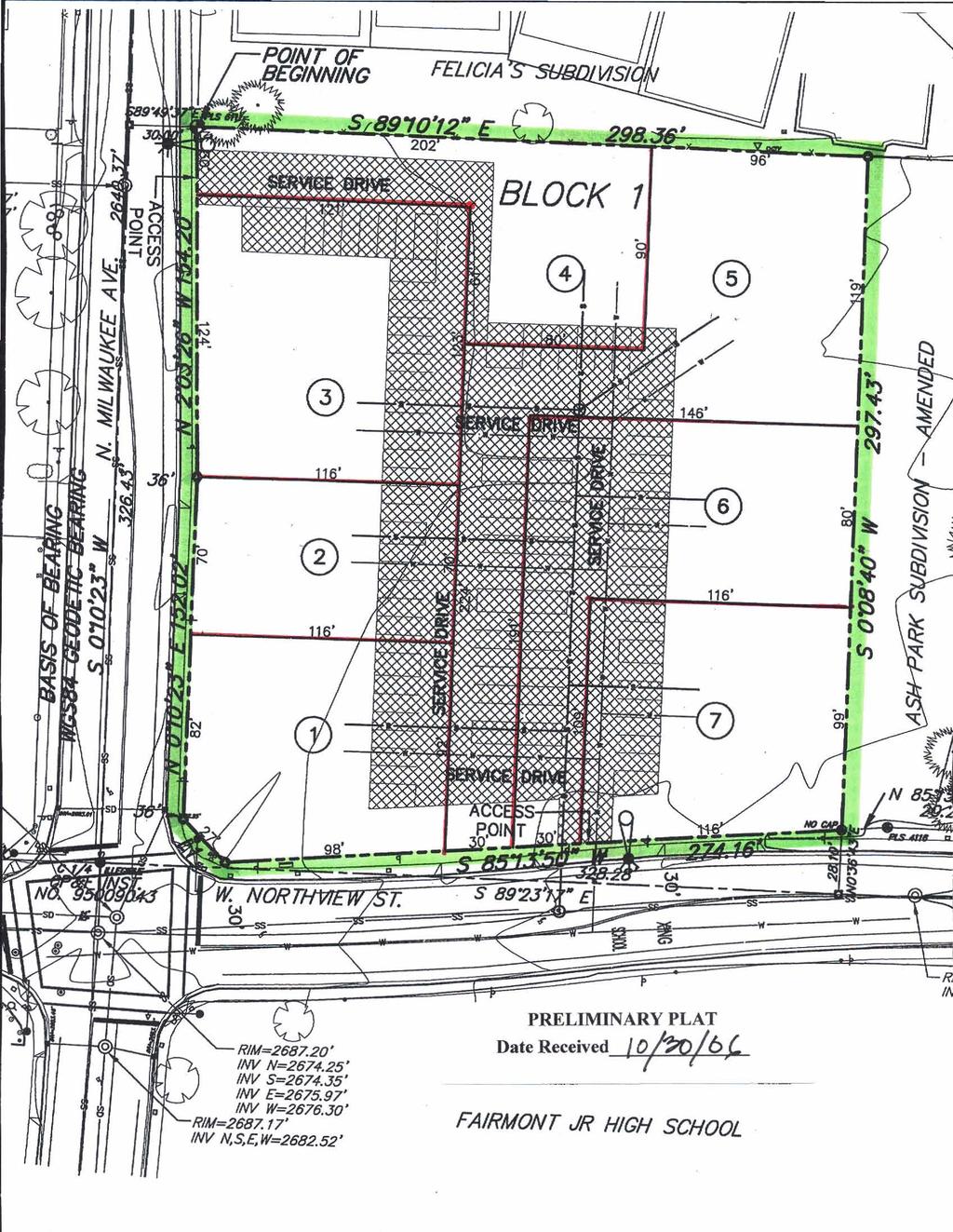
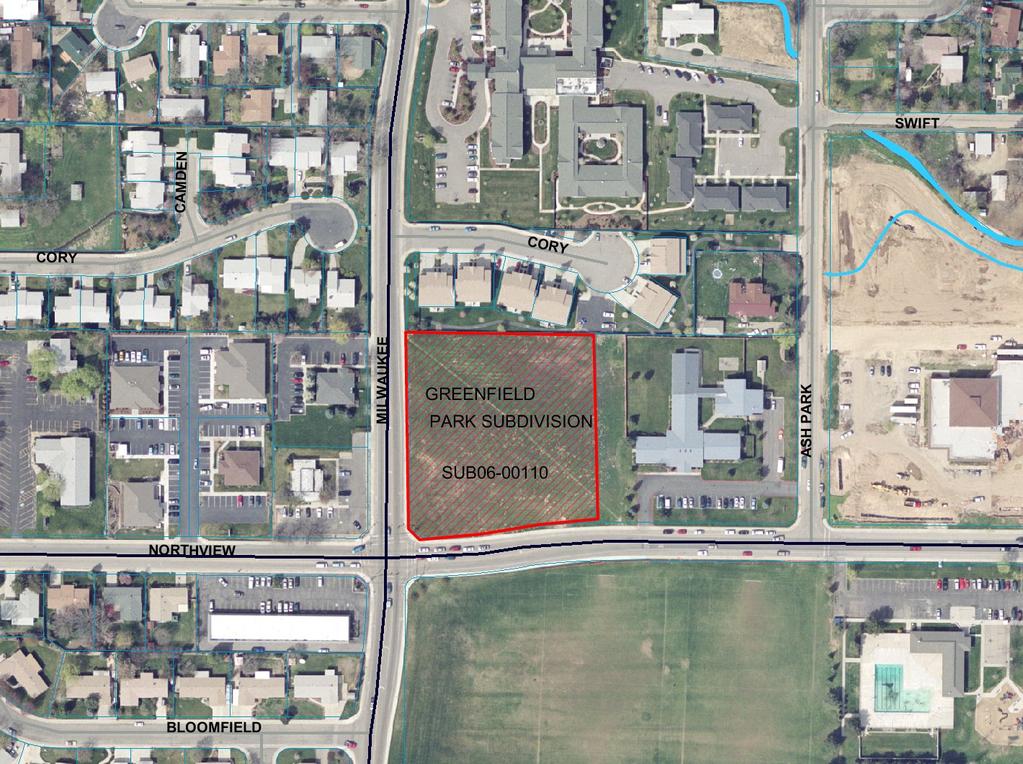
1 Subdivision Staff Report Subdivision Name Greenfield Park File Number SUB Subdivision Approval Preliminary/Final Plat Lead Agency Boise City Annexation Date December 9, 1974 Comp. Plan Complies Public Hearing Date January 30, 2007 Heard by Boise City Council Planning and Zoning Commission Approval December 11, 2006 Analyst Joan Johnson Description: This is a proposed seven lot office subdivision on 2.09 acres of vacant land. The site is currently zoned L-OD. The proposal also includes a perpetual ingress/egress easement and cross parking easement intended to provide internal driveway access and parking to all of the buildable office pad sites. Location: The site is located at the northeast corner of N. Milwaukee Street and W. Northview Street. Traffic: Roadway Frontage Functional Classification Traffic Count Level of Service* Milwaukee 320 Minor Arterial 13,405 north of C Street Northview on 02/14/ Major Better than Northview Collector C Street 5,246 west of Cole on 11/16/2005 Speed Limit 30 MPH 25 MPH Contents: Basis for Recommendation Vicinity Map Preliminary Plat Final Plat Aerial Map Recommended Conditions of Approval Technical Review and Agency Comments
2 Page 2 of 20 Basis for Recommendation The Boise City Planning and Zoning Commission recommended approval of the Preliminary/Final Plat of the Greenfield Park Subdivision on December 11, The plat design and layout is in conformance with the Comprehensive Plan and complies with the basic requirements of the Boise City Subdivision and Zoning Ordinances. Condition 1 This condition requires compliance with the Ada County Highway District s requirements regarding public street improvements and driveway locations. Condition 2 This condition requires compliance with the Ada County Highway District s requirements regarding closure of two curb cuts (one each) accessing the public streets. Condition 3 Condition 4 This condition addresses requirements for a perpetual ingress/egress access easement and cross parking easement. This condition requires compliance with the requirements of the Nampa & Meridian Irrigation District. Staff Perspective General The recommended conditions of approval are required to bring the proposed Preliminary/Final Plat into compliance with Boise City and Idaho State Codes and have been confirmed by the Boise City Planning and Development Services Department. Staff has reviewed the agency comments and Staff recommends approval based upon Staff's finding that all concerns of the commenting agencies have been addressed. To avoid potential problems the developer is directed to review the concerns identified in the technical reviews to verify that this statement is correct. Street Connectivity The applicant is not proposing to construct any additional rights-of-way. As such, there is no opportunity to extend any stub streets. Sidewalk Design The site is currently improved with sidewalks on Milwaukee and Northview Streets. The elimination of two of the four existing driveway accesses onto the site will partially mitigate traffic movement conflicts as noted by ACHD. Staff is recommending a condition for internal sidewalks between the parking area and the buildings. None known. Conditions in Dispute
3
4

5 GREENFIELD PARK SUBDIVISION LOCATED IN A PDRTlON OF LOT 48 OF ME AMENDED PLAT OF ASH PARK AS SHOWN IN BOOK 4 OF PLATS ON PAGE 164. RECORDS OF ADA COUNTY. IDAHO. AND ALSO BEING LOCATED IN ME SW 1/4 OF THE NE 1/4 OF SECTION 1, T.3N.. RIE.. BOISE MERIDIAN. BOISE CITY. ADA COUNTY. IDAHO' 2007 S"bd** wnoor. Lclb Un. LO, L". bu Psmnt LSI. (3.- Moll I 171 Lot Yynb* rwnd mw. Ir wn c* F d s/a. Ih" Pa. 0. not- Cdm4~L.d Poht SCALE IN FEET Xlr~~/ommlbo Lkk. 1. = 3V Pqebd qn./osc.ss eosrmnt md.=limp msrnnt 1%. not- 6 L 1) RECEIVED JAN 1 I 2007 PLANNING DEPT. SUBDIVISIONS
6
7 Page 3 of 20 Recommended Conditions of Approval Special Conditions and Plat Notes 1. The Applicant shall comply with the Ada County Highway District s requirements regarding infrastructure improvements to Milwaukee Street and Northview Street and driveway locations as they abut the subject property. 2. Close all existing curb cuts agreed upon to both Milwaukee Street and Northview Street to match the surrounding improvements. Except for the driveways specifically approved with this application, no access is allowed to either Milwaukee Street or Northview Street and a note of these access restrictions should be included on the Final Plat. 3. The following perpetual ingress/access easement and perpetual cross parking easement requirements must be met: A. A note on the face of the Final Plat is required, which sets forth the legal description of the perpetual ingress/access easement and cross parking easement, and Conveys to those lot owners taking access from the perpetual ingress/access easement, the perpetual right of ingress and egress and parking over the described easement, and Provides that such perpetual ingress/access easement and cross parking easement shall run with the land. B. A restrictive covenant for maintenance shall be recorded at the time of recording the Final Plat which covenant, (a) creates the formation of a homeowners association for the maintenance of the perpetual ingress/access easement and cross parking easement and (b) provides that said covenant shall run with the land, and (c) provides that the homeowners association shall not be dissolved without the express consent of Boise City. Said perpetual ingress/access easement and covenant to be reviewed and approved by the Boise City Attorney (B.C.C E.2.p). C. The service driveway widths shall a minimum of 22 feet wide with two way traffic and parking on both sides or 20 feet with two way traffic and parking on one side. All service driveways shall be constructed to the same construction specifications required for public streets. Contact the Ada County Highway District for public street construction requirements (B.C.C E). Certification of construction to A.C.H.D. specifications is required from an independent testing laboratory or a consulting engineer, including test results for the verification of construction (B.C.C E.2.s).
8 Page 4 of 20 D. Sidewalks are required between the parking area and the buildings. E. Drainage facilities for the perpetual ingress/access easement and parking area shall comply with Boise City s Storm Water Management and Discharge Control Ordinance (B.C.C. 8-15). Plans shall be approved and construction inspected by Boise City Public Works. F. The perpetual ingress/access easement shall be designed to accommodate the turning radius of fire trucks, as determined by the Boise City Fire Department. Plans shall be submitted, reviewed and approved by the Boise City Fire Department and the Boise City Public Works Department prior to signing of the Final Plat by the Boise City Engineer. G. The perpetual ingress/access easement shall be required to support the use of emergency vehicles having a 70,000 lb. GVW, and verification of construction is required from an independent testing laboratory and a registered Professional Engineer. H. Provide a perpetual ingress/egress access easement and cross parking agreement, and perpetual maintenance agreement and legal description. Prior to recordation, the perpetual ingress/access easement and cross parking easement agreement and perpetual maintenance agreement shall be subject to review and approval by the Boise City Legal Staff. Prior to issuance of a Building Permit, the applicant shall record the perpetual ingress/access easement and cross parking agreement, and perpetual maintenance agreement and provide a copy to the Boise City Planning and Development Services Department. The easement agreement shall also include provisions stating that the easement shall run with the land, and that the easement cannot be dissolved without the express consent of the City of Boise. I. The easements shall be clearly depicted on the Final Plat. 4. Compliance with the previously noted requirements of the Nampa & Meridian Irrigation District is required. Covenant Requirements 5. Covenants, homeowners association by-laws or other similar deed restrictions acceptable to the Boise City Attorney, which provide for the use, control and maintenance of all common areas, storage facilities, access and parking areas or open spaces shall be reviewed and approved by the Boise City Attorney. Erosion Control Requirements
9 Page 5 of Prior to the Boise City Engineer's Certification of the Final Plat and prior to earth disturbing activities, an erosion and sediment control (ESC) permit must be obtained. An ESC plan conforming to the requirements B.C.C. Title 8 Chapter 17, is to be submitted to the Planning Director of Boise City Planning and Development Services Department for review and approval. No grading or earth disturbing activities may start until an approved ESC permit has been issued. 7. An individual who has attended the Boise City Responsible Person (RP) certification class, or has obtained Interim Certification for Responsible Person is not identified for this project. A permit will not issue until such time as the name and certification number of the RP has been provided to Boise City. This information can be faxed to or ed to swebb@cityofboise.org. Irrigation Conditions 8. Comply with Boise City Code Section J and Idaho Code, Section concerning irrigation rights, transfer and disclosure. Proof of compliance shall be in the form of the following: A. The water rights appurtenant and the assessment obligation of the lands in said subdivision which are within the irrigation entity have been transferred from said lands or excluded from an irrigation district by the owner thereof; or by the person, firm or corporation filing the subdivision plat; or B. The owner or person, firm or corporation filing the subdivision plat has provided for underground tile or other like satisfactory underground conduit to permit the delivery of water to those landowners within the subdivision who are also within the irrigation entity. 9. No ditch, pipe or structure for irrigation water or irrigation waste water shall be obstructed, rerouted, covered or changed in any way unless such obstruction, rerouting, covering or changing has first been approved in writing by the ditch company officer in charge. A. A copy of such written approval by the ditch company officer shall be filed with the construction drawing and submitted to the Department of Planning and Development Services prior to signing of the Final Plat by the Boise City Engineer (B.C.C F.2). 10. Fence, cover or tile all irrigation ditches, laterals or canals and drains, exclusive of natural waterways, intersecting, crossing or lying adjacent to the subdivision prior to Final Platting or post bond in the amount of 110% of the estimated improvement cost with the Boise City Planning and Development Services Department. Adjacent is defined by the Boise City Code as "located within less than sixty feet (60') of any lot included in the development."
10 Page 6 of 20 A. Any covering or fencing program involving the distribution of any irrigation district shall have the prior approval of the affected district. B. If the developer requests a water amenity, such request shall comply with B.C.C F.5. C. Fencing shall be installed within 90 days of the issuance of the first building permit in the development, if building permits are obtained prior to completion of fencing improvements. Sewer Condition 11. Wet lines sewers are required. The developer shall provide Boise City Public Works Department with a letter from the West Boise Sewer District stating that sewer has been installed and has been accepted for service or provide evidence, by way of contract or other means, which assures sewer service will be provided and that the necessary bonding are in place to assure completion of said sewer. Street Light Conditions 12. Developer shall delineate on the face of the Final Plat a Boise City street light easement, acceptable to the Boise City Department of Public Works, for the purpose of installing and maintaining city-owned street light fixtures, conduit and wiring lying outside the dedicated public right-of-way (B.C.C F). 13. The developer shall be required to install, at their expense, street lights in accordance with Boise City Public Works specifications and standards at locations designated by the Public Works Department (B.C.C H). Plans shall be reviewed and approved by the Boise City Public Works Department prior to commencement of construction, bonding, or payment into trust fund. Fees: Developer shall pay the current street light inspection and plan review fees on the proposed condominium (B.C.C ). A. The street lights shall be installed and accepted by the Boise City Public Works Department at the following locations. Unless otherwise noted, street lights shall be installed at a 25-foot minimum mounting height, 100 W.H.P.S. 1) N.W. Corner Lot 3, Block 1 2) S.W. Corner Lot 7, Block 1 B. If bonding approval is granted by the Boise City Public Works Department, developer may bond in the amount of 110% of the estimated street light costs. Street lights shall be installed within 90 days of the issuance of the first building permit in the development, if building permits are obtained prior to completion of street light
11 Page 7 of 20 General Conditions improvements. 14. The developer shall make arrangements to comply with all requirements of the Boise City Fire Department and verify in one of the following ways: A. A letter from the Boise City Fire Department stating that all conditions for water, access, and/or other requirements have been satisfied, B. A non-build agreement has been executed and recorded with a note on the face of the Final Plat identifying the instrument number. NOTE: OR 1) No Parking signs and curb painting shall be required on streets having a width less than 36-feet, back of curb to back of curb. Contact the Boise City Fire Department for sign placement and spacing. Developer may either construct prior to Final Platting or post bond in the amount of 110% of the estimated costs with the Boise City Planning and Development Services Department. 15. The name, Greenfield Park Subdivision, is reserved and shall not be changed unless there is a change in ownership, at which time, the new owner(s) shall submit their new name to the Ada County Surveyor for review and reservation. Should a change in name occur, applicant shall submit, in writing, from the Ada County Surveyor, the new name to the Department of Planning and Development Services and re-approval by the Council of the "revised" Final Plat shall be required. Developer and/or owner shall submit all items including fees, as required by the Planning and Development Services Department, prior to scheduling the "revised" Final Plat for hearing. 16. Correct street names as approved by the Ada County Street Name Committee shall be placed on the plat (I.C. Title 50, Chapter 13). 17. A letter of acceptance for water service from the utility providing same is required (B.C.C C). 18. Developer shall provide utility easements as required by the public utility providing service (B.C.C F). 19. A letter from the appropriate school district is required stating, "The Developer has made arrangements to comply with all requirements of the School District."
12 Page 8 of Developer shall provide a letter from the United States Postal Service stating, "The Developer and/or Owner has received approval for location of mailboxes by the United States Postal Service." Contact: John Ballard, Postmaster 770 S. 13th St. Boise, ID Phone No. (208) FAX No. (208) Approval of sewer and water facilities by the Central District Health Department is required (I.C. Title 50, Chapter 13). 22. Developer shall comply with all construction standards of Ada County Highway District including approval of the drainage plan, requirements for installing curb, gutter, sidewalks and paving throughout the subdivision as specified by the Boise City Council. Signature by the Ada County Highway District on the Final Plat is required (I.C. Title 50, Chapter 13). 23. Prior to submitting the Final Plat for recording, the following endorsements or certifications 3must be executed: Signatures of owners or dedicators, Certificate of the Plat Surveyor, Certificate of the Ada County Surveyor, Certificate of the Central District Health Department, Certificate of the Boise City Engineer, Certificate of the Boise City Clerk, signature of the Ada County Highway District Commissioners and the Ada County Treasurer (I.C. Title 50, Chapter 13). 24. Developer shall comply with Boise City Code D.2 which specifies the limitation on time for filing and obtaining certification. Certification by the Boise City Engineer shall be made within two years from date of approval of the Final Plat by the Boise City Council. A. The developer may submit a request for a time extension, including the appropriate fee, to the Boise City Planning and Development Services Department for processing. Boise City Council may grant time extensions for a period not to exceed one year provided the request is filed, in writing, at least twenty working days prior to the expiration of the first two year period, or expiration date established thereafter. B. If a time extension is granted, the Boise City Council reserves the right to modify and/or add condition(s) to the original preliminary or Final Plat to conform with adopted policies and/or ordinance changes. A. The Final Plat shall be recorded with the Ada County Recorder within one year from the date of the Boise City Engineer s signature. If the Final Plat is not recorded within the one-year time frame it shall be deemed null and void. 25. The Greenfield Park Subdivision is approved for seven buildable lots.
13 Page 9 of 20 Technical Review and Agency Comments Boise City Planning and Development Services Subdivision Section Joan Johnson Staff has reviewed the Preliminary Plat and noted that all proposed lots conform to the minimum dimensional standards of the Boise City Zoning Ordinance in the L-OD Zoning District. The applicant has not requested a Conditional Use Permit for this property. Comprehensive Planning and Zoning Section Joan Johnson The Boise City Comprehensive Plan Land Use Map designates the subject parcel for Office development. This project is located in the West Bench Planning Area. There are no specific objectives or policies from this planning area that apply to this site. Other goals, objectives and policies in the Boise City Comprehensive Plan that relate to this project are: 6.0 TRANSPORTATION 6.1 Streets Goal) Maintain the function of the street system for current users, emergency response efforts and for use by future generations. Objective 4) Promote land use policies that limit access as necessary to maintain safe and efficient operation of the existing street system while allowing reasonable access to individual development parcels. Policy 4) Limit access to all arterial streets. Policy 5) Develop grid systems at commercially zoned arterial intersections, where feasible, in order to support increased traffic. Policy 6) Improve access control on existing streets through the review of new developments. Policy 8) Develop methods, such as cross-access agreements, frontage and backage roads, to reduce the number of existing access points onto arterial streets. Policy 9) Work with adjacent jurisdictions to develop more restrictive access limitations than presently exist for arterials and highways of regional transportation importance. Analysis of Compliance with Transportation Chapter Policies: This development has two existing access points onto Northview Street, and two existing access points onto Milwaukee Street which do
14 Page 10 of 20 not meet the minimum ACHD signalized intersection to driveway offset policy standards. The developer has agreed with ACHD to close one access point on each street leaving the opportunity to utilize one access point on each roadway. This will assist the municipality in its endeavors to maintain a pattern of positive traffic flow and limit access control near this intersection. The preliminary plat includes a cross access and parking easement affording property owners and consumers internal circulation and parking access. 6.5 Landscaping Goal) Create a transportation system that is visually attractive and conducive to pedestrian travel. Objective 1) Accommodate appropriate landscaping elements within and adjacent to the public streets right-of-way. Objective 6) Discourage waiver by ACHD of landscape strip requirements, and encourage that landscape strips always be required along gateway arterials and collectors and in areas already characterized by existing landscape strips. 7.0 COMMUNITY QUALITY 7.2 Community Design Goal) Create a community composed of neighborhoods in which services and amenities are convenient, visually pleasing and properly integrated and designed to encourage walking and cycling. Objective 4) Reinforce the development of functional and visually appealing neighborhoods. 8.0 LAND USE Goal) Achieve a city that minimizes suburban sprawl, that provides for a diverse mixture of lifestyles and atmospheres and a sense of place that varies throughout the different areas of the city, and that efficiently provides basic services and facilities in close proximity to where people live. The Comp Plan Land Use Map designates this parcel as Office. The proposed subdivision is zoned L- OD. This designation is consistent with the Land Use/ Zoning Consistency Matrix (Table 8.1-1). Objective 1) The land-use map and attendant policies shall be the official guide for development of the planning area and shall be implemented through zoning and development review. Objective 4) New commercial and office developments shall be located to be convenient to shoppers and employees and to minimize adverse impacts on the street system and adjacent uses. Policy 5) Office uses are appropriately located along arterials and collectors and may be used as buffers between intense retail uses and residential uses.
15 Page 11 of 20 Policy 6) The creation of single-use commercial and office districts shall be discouraged, while uses that serve a variety of shopping, entertainment, work and dwelling needs, and have differing hours of operation, shall be encouraged. Objective 10) Compatibility of uses shall be provided through adherence to the land-use map and through special design and review procedures. Policy 1) Special design treatments shall be required to provide compatibility of new development with existing development such as building orientation, increased setbacks, height limitations, size restrictions, design requirements, special fencing, landscaping requirements or other methods to be determined through the development review process. CHAPTER 10 GROWTH MANAGMENT Goal 10) Preserve, protect and enhance the overall quality of life in Boise and its Area of Impact by ensuring that growth occurs in an orderly manner and that public services are available along with development. Objective 1) Ensure that growth is planned and directed in a way that minimizes sprawl and creates a functional and pleasing community. Objective 3) Require development to address its own impacts, including financial and environmental. Building Section - Marlene Southard No comment. Sediment and Erosion Control Steve Webb An erosion and sediment control plan (ESC) conforming to the requirements B.C.C. Title 8 Chapter 17 is to be submitted to the Director of Planning and Development Services for review. No grading or earth disturbing activities may start until approval of the ESC plan has been received and an ESC permit issued. An individual who has attended the Boise City Responsible Person (RP) certification class, or has obtained Interim Certification for Responsible Person is not identified for this project. A permit will not issue until such time as the name and certification number of the RP has been provided to Boise City. Boise City Public Works: Drainage/Hillside - Terry Records Pressure Irrigation is required. Comply with standard drainage conditions. Engineering - Rob Bousfield Standard drainage conditions. Pressure Irrigation - Kent Johnson Comply with Idaho Code, Section and Boise City Code Section J
16 Page 12 of 20 Sewer - John Johnson Sewer easements are required. Compliance with Boise City Sewer Tap Ordinance is required. West Boise Sewer District Patricia Roe, November 21, 2006 The proposed Greenfield Park Subdivision is within the boundaries of the West Boise Sewer District (WBSD). All administrative matters including permits and payment of required fees, must be completed before the District will accept sewer flows from this project. Plus, any establishment which engages in food preparation, is required to install, operate and maintain such grease traps or grease interceptors as the District may require to prevent the discharge of fats, oils and/or grease into the District s sanitary sewage system in amounts that could restrict or interfere with the flow of sewage in the District s sewer system. The owner/developer will need to enter into a Contract for Line Extension of Sewer Service with the District. This development s proposed seven lots may exceed the planned allowable sewer density for the parcel depending on what is built. Accordingly, the District may assess overdensity charges. The District s policy is to have its facilities located within the public right-of-way. In this case of a service drive under which District facilities will be located, a separate recorded easement will be required prior to Final Platting. If there are questions call Street Lights - Henry Alarcon, November 7, 2006 Two street lights are required 30ft. minimum mounting height, 250/400 W.H.P.S. on the northwest corner of Lot 3, Block 1 and the southwest corner of Lot 7, Block 1. Nampa & Meridian Irrigation District- Bill Henson, November 15, 2006: If all storm drainage is retained on site there will be no impact on Nampa & Meridian Irrigation District and no review is required. All municipal surface drainage must be retained on site, or if any drainage leaves the site, the District must review and approve drainage plans. The District requires that a Land Use Change Application be filed, for review prior to Final Platting. All laterals and waste ways must be protected. The developer must comply with Idaho Code It is recommended that irrigation water be made available to all developments within the Nampa & Meridian Irrigation District. All work within the District must be completed prior to March 15, Please call with any questions. Boise City Fire Department - David Miller, November 7, 2006 The Boise Fire Department has reviewed this application and can approve the Preliminary Plat with the following conditions. Any deviation from this plan is subject to Fire Department approval. Please note that unless stated otherwise this memo represents requirements of the International Fire Code as adopted and amended by Ordinance Specific Requirement:
17 Page 13 of 20 Fire Department vehicular access shall be provided to within 150' of all portions of the nonsprinklered buildings. This distance can be increased somewhat for sprinklered buildings but exact distances are on a case-by-case basis. All Fire Department access roads, fire lanes, bridges, and gates are to be a minimum of 20' wide with 13' 6" overhead clearance, shall be capable of supporting 70,000 lbs GVW (24,000 lbs per axle), and shall be paved. Fire Department access roads and fire lanes shall have a minimum outside turning radius of 48' with an inside radius of 28'. Any dead-end road in excess of 150' needs a Fire Department approved turnaround. No grade may exceed 10% (please note that fire apparatus are designed for a maximum 6% grade). Dead end roads are prohibited from exceeding 700 feet. Width and turning radius measurements specified by this paragraph can include those surfaces vehicles generally drive upon. Specifically, gutter and rolled curb are generally considered useable, while vertical curb or sidewalks are not. Specific Condition: The cross hatching makes the print difficult to read. It appears that some of the turning radius do not meet IFC requirements. Specific Requirement: For streets having a width less than 36 feet back of curb to back of curb parking shall be restricted on (1) one side; for streets having a width less than 29 feet back of curb to back of curb parking shall be restricted on both sides; and for standard ACHD cul-de-sacs parking shall be restricted on both sides. A note on the face of the Final Plat is required noting the parking restriction prior to signing of the Final Plat by the Boise City Engineer. Specific Condition: Streets must be marked accordingly. Specific Requirement: Maximum hydrant spacing for one and two family dwellings is 500 feet between hydrants, and 300 feet between hydrants for all other buildings. Specific Condition: No fire hydrants have been noted. In the absence of information on existing hydrants it appears that several new hydrant may/will be needed. However, we reserve the right to modify requirements as more information comes to light. Variables affecting hydrant numbers and location include, but are not limited to, area, construction type, existing hydrants, accuracy of information provided in the application, strategic location for fire fighting forces, and required fire flow. New hydrants must be "non-private" installations. General Requirement: Fire Department required fire hydrants, access, and street identification shall be installed prior to construction or storage of combustible materials on site. Provisions may be made for temporary access and identification measures.
18 Page 14 of 20 Specific building construction requirements of the International Building Code, International Fire Code, and Boise City Code will apply. However, these provisions are best addressed by a licensed Architect at building permit application. Boise City Parks Department - Cheyne Weston No comments received. Boise Airport - John Anderson No comments received. Ada County Highway District Andrew Mentzer Staff Level Approval: November 14 th 2006 Application Information: Acreage: 2.09 Current Zoning: LOD Proposed Zoning: LOD Commercial Lots: 7 A. Findings of Fact Existing Conditions 1. Site Information: The site is currently vacant. 2. Description of Adjacent Surrounding Area: Direction Land Use Zoning North Residential R-2D South Vacant A-1 East Commercial L-OD West Commercial L-OD 3. Existing Roadway Improvements & Right-of-Way Milwaukee Street is currently improved with 2 travel lanes, a center left hand turn lane, bike lanes, vertical curb, gutter and a 7-foot attached concrete sidewalk abutting the site. Milwaukee Street currently has between 62 and 66-feet of right-of-way. Northview Street is currently improved with 2 travel lanes, a center left hand turn lane, bike lanes, vertical curb, gutter, and a 7-foot attached concrete sidewalk abutting the site. Northview Street currently has 60-feet of right-of-way.
19 Page 15 of Existing Access: There are currently two curb cuts accessing the site from Milwaukee Streetand two curb cuts accessing the site from Northview Street. 5. Site History: ACHD has not previously reviewed this site for a development application. Development Impacts 1. Trip Generation: This development is estimated to generate approximately 200 additional vehicle trips per day based on the Institute of Transportation Engineers Trip Generation Manual, General Office land use designation. 2. Impact Fees: There will be an impact fee that is assessed and due prior to issuance of any building permits. The assessed impact fee will be based on the impact fee ordinance that is in effect at that time. 3. Traffic Impact Study: A traffic impact study was not required with this application. 4. Impacted Roadways: Roadway Frontage Functional Classification Traffic Count Level of Service* Milwaukee 320 Minor Arterial 13,405 north of C Street Northview on 02/14/ Major Collector Better than Northview C Street 5,246 west of Cole on 11/16/2005 *Acceptable level of service for a 2 lane minor arterial is D (14,000 VTD). *Acceptable level of service for a 2-lane major collector is D (7,000 VTD). Speed Limit 30 MPH 25 MPH 5. Capital Improvements Plan/Five Year Work Program There are currently no roadways, bridges or intersections in the general vicinity of the project that are currently in the Five Year Work Program or in the Capital Improvements Plan. B. Findings for Consideration 1. Tree Planter Policy Tree Planter Policy: The applicant should also comply with the District s Tree Planter Width Interim Policy which prohibits all trees in planters less than 6-feet in width. In addition to prohibiting trees in planters less than 6-feet in width, the policy requires a minimum planter width of 6-feet for class II tress with the installation of root barriers on both sides of the planter strip or a minimum planter width of 8-feet without the installation of a root barrier.
20 Page 16 of 20 The policy also requires Class I and Class III trees to provide a minimum planter width of 10- feet. 2. Milwaukee & Northview Right-of-Way Policy: District policy requires 70-feet of right-of-way on collector and 3-lane arterial roadways (Figure 72-F1B). This right-of-way width allows for the construction of a 3-lane roadway with curb, gutter, 5-foot wide detached sidewalks and bike lanes. Sidewalk Policy: District policy requires 7-foot wide attached (or 5-foot detached) concrete sidewalk on all collector roadways and arterial roadways ( ). Applicant Proposal: The applicant is not proposing to construct any improvements to Milwaukee Street or Northview Street. Staff Recommendation: Due to the fact that Northview Street and Milwaukee Street are fully improved, the applicant should not be required to construct any additional improvements or dedicate any additional right-of-way. 3. Driveway Access Offset Policy: District policy 72-F4 (1) requires driveways located on collector roadways near a signalized intersection to be located a minimum of 175-feet from the signalized intersection for a full-access driveway and a minimum of 85-feet from the signalized intersection for a right-in/right-out only driveway; District policy 72-F4 (1) requires driveways located on arterial roadways near a signalized intersection to be located a minimum of 440-feet from the signalized intersection for a full-access driveway and a minimum of 220- feet from the signalized intersection for a right-in/right-out only driveway. Paving Policy: Graveled driveways abutting public streets create maintenance problems due to gravel being tracked onto the roadway. In accordance with District policy, , the applicant should be required to pave the driveway its full width and at least 30-feet into the site beyond the edge of pavement of the roadway and install pavement tapers with 15-foot radii abutting the existing roadway edge. Width Policy: District policy restricts commercial driveways with daily traffic volumes over 1,000 vehicles to a maximum width of 36-feet. Most commercial driveways will be constructed as curb-cut type facilities if located on local streets. Curb return type driveways with 15-foot radii will be required for driveways accessing collector and arterial roadways. Applicant Proposal: The applicant is proposing to construct two access points to the site. The first driveway is a 30-foot curb cut intersecting Northview Drive approximately 168-feet east of the intersection with Milwaukee Street. The second driveway is a 30-foot wide curb cut intersecting Milwaukee Street approximately 293-feet north of the intersection with Northview Street.
21 Page 17 of 20 Staff Recommendation: The applicant should be required to construct the first proposed driveway (intersecting Northview Street) a minimum of 175-feet from the intersection of Northview and Milwaukee. The ideal location of this driveway would be a shared access easement at the east property line (consolidating the access with the parcel to the east). This approach should be constructed as a curb return, be no greater than 36-feet wide, be paved its entire width and at least 30- feet into the site. If the applicant chooses to utilize an access anywhere adjacent to the left hand turn bay on Northview Street, ACHD reserves the right to restrict this access to right-in/right-out ONLY in the future, due to the potential for dangerous turning conflicts. The second proposed driveway should be approved where proposed as a right-in/right-out ONLY access. It should be constructed as a curb return approach, no greater than 36-feet wide, paved its entire width and at least 30-feet into the site. Additionally, the applicant should close all existing curb cuts to both Milwaukee and Northview, to match the surrounding improvements. Except for the driveways specifically approved with this application, no access should be allowed to either Milwaukee Street or Northview Street. A notation of these access restrictions should be included on the Final Plat. C. Site Specific Conditions of Approval 2. Construct a 30-foot wide curb return driveway intersecting Northview Street a minimum of 175-feet from the intersection of Northview and Milwaukee. The ideal location of this driveway would be a shared access easement at the east property line (thereby consolidating an access with the adjacent parcel). ACHD reserves the right to restrict this access to rightin/right-out ONLY if turning conflicts create safety concerns in the future. 3. Construct a 30-foot wide curb return driveway intersecting Milwaukee Street approximately 293-feet north of the intersection with Northview Street as a right-in/right-out ONLY approach. This access should be paved its entire width and at least 30-feet into the site. 4. Close all existing curb cuts to both Milwaukee and Northview to match the surrounding improvements. Except for the driveways specifically approved with this application, no access should be allowed to either Milwaukee Street or Northview Street. A notation of these access restrictions should be included on the Final Plat. 5. Comply with all Standard Conditions of Approval. D. Standard Conditions of Approval 1. Any existing irrigation facilities shall be relocated outside of the right-of-way. 2. Private sewer or water systems are prohibited from being located within any ACHD roadway or right-of-way. 3. All utility relocation costs associated with improving street frontages abutting the site shall be borne by the developer.
22 Page 18 of Replace any existing damaged curb, gutter and sidewalk and any that may be damaged during the construction of the proposed development. Contact Construction Services at (with file number) for details. 5. Comply with the District s Tree Planter Width Interim Policy. 6. Utility street cuts in pavement less than five years old are not allowed unless approved in writing by the District. Contact the District s Utility Coordinator at (with file numbers) for details. 7. All design and construction shall be in accordance with the Ada County Highway District Policy Manual, ISPWC Standards and approved supplements, Construction Services procedures and all applicable ACHD Ordinances unless specifically waived herein. An engineer registered in the State of Idaho shall prepare and certify all improvement plans. 8. The applicant shall submit revised plans for staff approval, prior to issuance of building permit (or other required permits), which incorporates any required design changes. 9. Construction, use and property development shall be in conformance with all applicable requirements of the Ada County Highway District prior to District approval for occupancy. 10. Payment of applicable road impact fees are required prior to building construction in accordance with Ordinance #200, also known as Ada County Highway District Road Impact Fee Ordinance. 11. It is the responsibility of the applicant to verify all existing utilities within the right-of-way. The applicant at no cost to ACHD shall repair existing utilities damaged by the applicant. The applicant shall be required to call DIGLINE ( ) at least two full business days prior to breaking ground within ACHD right-of-way. The applicant shall contact ACHD Traffic Operations in the event any ACHD conduits (spare or filled) are compromised during any phase of construction. 12. No change in the terms and conditions of this approval shall be valid unless they are in writing and signed by the applicant or the applicant s authorized representative and an authorized representative of the Ada County Highway District. The burden shall be upon the applicant to obtain written confirmation of any change from the Ada County Highway District. 13. Any change by the applicant in the planned use of the property which is the subject of this application, shall require the applicant to comply with all rules, regulations, ordinances, plans, or other regulatory and legal restrictions in force at the time the applicant or its successors in interest advises the Highway District of its intent to change the planned use of the subject property unless a waiver/variance of said requirements or other legal relief is granted pursuant to the law in effect at the time the change in use is sought.
23 Page 19 of 20 E. Conclusions of Law 1. The proposed site plan is approved, if all of the Site Specific and Standard Conditions of Approval are satisfied. 2. ACHD requirements are intended to assure that the proposed use/development will not place an undue burden on the existing vehicular transportation system within the vicinity impacted by the proposed development. Central District Health Department - Malcohm McGregor After written approval from appropriate entities are submitted, we can approve this proposal for central sewage and central water. The following plans must be submitted to and approved by the Idaho Department of Health and Welfare, Division of Environmental Quality: A. Central Sewage B. Central Water Street runoff is not to create a mosquito breeding problem. STORMWATER MANAGEMENT RECOMMENDATIONS We recommend that the first one half inch of stormwater be pretreated through a grassy swale prior to discharge to the subsurface to prevent impact to groundwater and surface water quality. The engineers and architects involved with the design of this project should obtain current best management practices for stormwater disposal and design a stormwater management system that is preventing groundwater and surface water degradation. Manuals that could be used for guidance are: 1) State of Idaho Catalog of Stormwater Best Management Practices For Idaho Cities and Counties. Prepared by the Idaho Department of Environmental Quality, July ) Stormwater Best Management Practices Guidebook. Prepared by City of Boise Public Works Department, May Independent School District of Boise City #1 Sarah Stobaugh At the present time, the Developer and/or Owner have made arrangements to comply with all requirements of the Boise School District. The schools assigned to the proposed project area are: Elementary School: Valley View Junior High School: Fairmont High School: Capital
24 Page 20 of 20 United States Postal Service John Ballard, Postmaster The following are the basic conditions requested by the Postal Service. 1. In all new residential areas, service will be provided to Cluster Box Units (CBUs). It will be the responsibility of the contractor to pour a cement pad meeting the required specifications in a location(s) approved by the Postal Service. 2. The clustering of all boxes in one approved area is recommended for multi-family dwellings, e.g., condos, duplexes, triplexes, etc. All locations must still be approved. Fill-in development, defined as three or less residential lots, may receive the existing mode of delivery as the rest of the neighborhood. All locations must still be approved.
Subdivision Staff Report
 Subdivision Staff Report Subdivision Name Coldstream File Number SUB06-00040 Subdivision Approval Preliminary Plat Lead Agency Boise City Annexation Date December 9, 1974 Comp. Plan Complies Public Hearing
Let me know if I need to bring you any other documentation for this withdrawl. Thanks!
 >>> david benoit 11/27/2007 10:00 AM >>> Dave, I am set to be heard on the Cranston Corner Subdivision on December 4th in front of City council. I have sold this property and am requesting
Time Extension Staff Report
 Time Extension Staff Report Subdivision Name Therrin Subdivision File Number SUB06-00020 Approval Time Extension for Lead Agency Boise City Certification Signature of Boise City Engineer Annexation Date
Time Extension Staff Report
 Time Extension Staff Report Subdivision Name Lunara Subdivision File Number SUB07-00019 Approval Time Extension for Lead Agency Boise City Certification Signature of Boise City Engineer Annexation Date
Subdivision Staff Report
 Subdivision Staff Report Subdivision Name Toli Park Subdivision File Number SUB07-00035 Approval Preliminary Plat Lead Agency Boise City Annexation Date December 30, 1987 Comp. Plan Complies Public Hearing
Subdivision Staff Report
 Subdivision Staff Report Subdivision Name Madera Creek File Number SUB06-00068 Subdivision Approval Final Plat Lead Agency Boise City Annexation Date December 9, 1974 Comp. Plan Complies Public Hearing
Subdivision Staff Report
 Subdivision Staff Report Subdivision Name Honeymoon Cove Subdivision File Number SUB08-00005 Approval Preliminary/ Final Plat Lead Agency Boise City Annexation Date December 30, 2004 Comp. Plan Complies
Location: The subject property is located at the northeast corner of S. Holden Lane and E. Boise Avenue.
 Subdivision Staff Report Subdivision Name Tianna Park File Number SUB11-00008 Approval Preliminary Plat Lead Agency Boise City Annexation Date December 19, 1977 Comp. Plan Complies Public Meeting Date
Subdivision Staff Report
 Subdivision Staff Report Subdivision Name Birmingham Place File Number SUB06-00051 Subdivision Approval Preliminary/Final Plat Lead Agency Boise City Annexation Date December 3, 1962 Comp. Plan Complies
Subdivision Staff Report
 Subdivision Staff Report Subdivision Name Athletic Subdivision File Number SUB08-00023 Approval Preliminary/ Final Plat Lead Agency Boise City Annexation Date July 30, 1984 Comp. Plan Complies Public Hearing
Hal Simmons Planning Director Boise City Planning and Development Services. CAR / 1689 South Entertainment Avenue
 MEMORANDUM MEMO TO: FROM: Mayor and Boise City Council Hal Simmons Planning Director Boise City Planning and Development Services DATE: November 15, 2008 RE: CAR08-00019 / 1689 South Entertainment Avenue
Committed to Service
 Committed to Service Paul Woods, President Rebecca W. Arnold, Vice President Sara M. Baker, Commissioner Jim D. Hansen, Commissioner Kent Goldthorpe, Commissioner August 25, 2017 Development Services TO:
May 21, ACHD Board of Commissioners Stacey Yarrington, Planner II DRH /DRH
 Development Services Department May 21, 2013 TO: FROM: SUBJECT: ACHD Board of Commissioners Stacey Yarrington, Planner II DRH13-00106/DRH13-00108 Executive Summary: This is a design review application
Subdivision Staff Report
 Subdivision Staff Report Subdivision Name Sunnyridge Subdivision File Number SUB07-00007 Approval Preliminary Plat Lead Agency Ada County Annexation Date NA Comp. Plan Complies (With Conditions of Approval)
BOI / DRH Albertsons grocery market and fueling center & pad sites
 Paul Woods, President Rebecca W. Arnold, Vice President Sara M. Baker, Commissioner Jim D. Hansen, Commissioner Kent Goldthorpe, Commissioner March 28, 2017 To: Mark Palmer Albertsons Companies 250 E.
Date: March 16, Jake Centers ERD, LLC P.O. Box 1610 Eagle, ID Elevation Ridge Subdivision (SUB & PUD ) Street Address
 Street Address") Rebecca W. Arnold, President Sara M. Baker, Vice President John S. Franden, Commissioner Carol A. McKee, Commissioner David L. Case, Commissioner Date: March 16, 2012 To: Jake Centers ERD, LLC P.O. Box
Rebecca W. Arnold, President Sara M. Baker, Vice President John S. Franden, Commissioner Carol A. McKee, Commissioner David L. Case, Commissioner Date: March 16, 2012 To: Jake Centers ERD, LLC P.O. Box
Right-of-Way & Development Services Planning Review Division Committed to Service This application is approved at the staff level on February 1, 2006.
 Right-of-Way & Development Services Planning Review Division Committed to Service This application is approved at the staff level on February 1, 2006. Tech Review for this item was held with the applicant
Subdivision Staff Report
 Subdivision Staff Report Name: Brownstone Subdivision Date: May 12, 2004 File: SUB04-00041 Meeting: May 18, 2004 Approval: Preliminary To: City Council Lead Agency: Ada County (04-10-S) From: Richard Beck
Executive Summary: This is a preliminary plat to construct 8 residential lots and 2 commons lots with a private road on 3.87-acres in Meridian, Idaho.
 Development Services Department DATE: July 7, 2015 TO: FROM: SUBJECT: ACHD Board of Commissioners Stacey Yarrington, Planner III Kentucky Villas/ MPP15-0012/ PP15-009 Executive Summary: This is a preliminary
RE: CAR / 4280 N.
 MEMORANDUM TO: FROM: Mayor and Boise City Council Hal Simmons - Planning Director Boise City Planning and Development Services DATE: April 29, 2009 RE: CAR09-00006 / 4280 N. Eagle Road The following application
Committed to Service
 Committed to Service Kent Goldthorpe, President Paul Woods, Vice President Rebecca W. Arnold, Commissioner Sara M. Baker, Commissioner Jim D. Hansen, Commissioner July 18, 2016 Development Services TO:
3. The preliminary plats were approved on March 27, 2014 and August 14, 2014.
 Jim D. Hansen, President Sara M. Baker, Vice President Rebecca W. Arnold, Commissioner Kent Goldthorpe, Commissioner Paul Woods, Commissioner February 12, 2015 Development Services Department To: From:
If you have any questions, please feel free to contact me at (208)
") Sara M. Baker, President John S. Franden, Vice President Rebecca W. Arnold, Commissioner Mitchell A. Jaurena, Commissioner Jim Hansen, Commissioner Date: March 21, 2013 To: Subject: Hornet Construction
Sara M. Baker, President John S. Franden, Vice President Rebecca W. Arnold, Commissioner Mitchell A. Jaurena, Commissioner Jim Hansen, Commissioner Date: March 21, 2013 To: Subject: Hornet Construction
SUB /CAR /PUD
 Development Services Department Project/File: Lead Agency: Site address: Balntyre Court Subdivision/BPP16-0036/ SUB16-00066/CAR16-00035/PUD16-00040 This is a rezone, planned unit development, and subdivision
SECTION 7000 LAND DEVELOPMENT REQUIREMENTS
 SECTION 7000 LAND DEVELOPMENT REQUIREMENTS 7000 LAND DEVELOPMENT REQUIREMENTS... 1 7001 LEGISLATIVE AUTHORITY... 1 7001.1 LAND DEVELOPMENT... 1 7001.1.1 Title 40, Idaho Code... 1 7001.1.2 Idaho Code 40-1415
Amended Subdivision Staff Report
 Amended Subdivision Staff Report Subdivision Name Silverpine Subdivision File Number SUB06-00052 No.2 Approval Preliminary Plat Lead Agency Ada County Annexation Date NA Comp. Plan Complies (With Conditions
Subdivision Staff Report
 Subdivision Staff Report Subdivision Name Cayenne Corner File Number SUB06-00060 Subdivision Approval Final Plat Lead Agency Boise City Annexation Date January 1, 1987 Comp. Plan Complies Public Hearing
Committed to Service
 Committed to Service Sara M. Baker, President Rebecca W. Arnold, Vice President Jim D. Hansen, Commissioner Kent Goldthorpe, Commissioner Paul Woods, Commissioner January 16, 2018 Development Services
Date: August 29, Dave Scaggs (sent via ) Summit Development Inc th Ave. Rd. #384 Nampa, ID 83686
 Summit Development Inc th Ave. Rd. #384 Nampa, ID 83686") Sara M. Baker, President John S. Franden, Vice President Rebecca W. Arnold, Commissioner Mitchell A. Jaurena, Commissioner Jim Hansen, Commissioner Date: August 29, 2013 To: Dave Scaggs (sent via email)
Sara M. Baker, President John S. Franden, Vice President Rebecca W. Arnold, Commissioner Mitchell A. Jaurena, Commissioner Jim Hansen, Commissioner Date: August 29, 2013 To: Dave Scaggs (sent via email)
Section Preliminary Plat Checklist and Application Forms
 Section 201 - Preliminary Plat Checklist and Application Forms PRELIMINARY SUBDIVISION PLAT REVIEW PROCESS CHART PRELIMINARY SUBDIVISION PLAT APPLICATION PRELIMINARY PLAT REVIEW CHECKLIST CITY OF NAMPA
ARTICLE IV: DEVELOPMENT STANDARDS
 ARTICLE IV: DEVELOPMENT STANDARDS IV-53 409 PRIVATE STREETS A private street means any way that provides ingress to, or egress from, property by means of vehicles or other means, or that provides travel
#1 (CAR /SUB )
") Development Services Department Project/File: Lead Agency: Site address: Fork South #1 (CAR14-00009/SUB14-00024) The applicant is requesting annexation, rezone and preliminary plat approvals for a 52-lot
Development Services Department Project/File: Lead Agency: Site address: Fork South #1 (CAR14-00009/SUB14-00024) The applicant is requesting annexation, rezone and preliminary plat approvals for a 52-lot
a. provide for the continuation of collector streets and thoroughfare streets between adjacent subdivisions;
 Section 7.07. Intent The requirements of this Section are intended to provide for the orderly growth of the Town of Holly Springs and its extra-territorial jurisdiction by establishing guidelines for:
APPLICATION PROCEDURE
 ANTRIM PLANNING BOARD P. O. Box 517 Antrim, New Hampshire 03440 Phone: 603-588-6785 FAX: 603-588-2969 APPLICATION FORM AND CHECKLIST FOR MINOR OR MAJOR SITE PLAN REVIEW File Date Received By APPLICATION
WRITTEN DECISION OF THE HAYDEN CITY COUNCIL REGARDING MAPLE GROVE PRELIMINARY SUBDIVISION APPLICATION (SUB-0013) HAYDEN SIGNATURE, LLC
 HAYDEN SIGNATURE, LLC") WRITTEN DECISION OF THE HAYDEN CITY COUNCIL REGARDING MAPLE GROVE PRELIMINARY SUBDIVISION APPLICATION (SUB-0013) HAYDEN SIGNATURE, LLC Application of Hayden Signature, LLC, an Idaho limited liability company,
WRITTEN DECISION OF THE HAYDEN CITY COUNCIL REGARDING MAPLE GROVE PRELIMINARY SUBDIVISION APPLICATION (SUB-0013) HAYDEN SIGNATURE, LLC Application of Hayden Signature, LLC, an Idaho limited liability company,
ARTICLE 24 PRIVATE ROAD, SHARED PRIVATE DRIVEWAY AND ACCESS EASEMENT STANDARDS
 ARTICLE 24 PRIVATE ROAD, SHARED PRIVATE DRIVEWAY AND ACCESS EASEMENT STANDARDS SECTION 24.00 INTENT AND PURPOSE The standards of this Article provide for the design, construction and maintenance of private
Chapter Plat Design (LMC)
") Chapter 18.14 Plat Design (LMC) Sections: 18.14.010 Lot width 18.14.020 Right-of-way requirements 18.14.030 Pipe stem lots 18.14.040 Division resulting in minimum lot sizes 18.14.050 Flood prone and bad
Chapter 18.14 Plat Design (LMC) Sections: 18.14.010 Lot width 18.14.020 Right-of-way requirements 18.14.030 Pipe stem lots 18.14.040 Division resulting in minimum lot sizes 18.14.050 Flood prone and bad
M-43 CORRIDOR OVERLAY ZONE
 ARTICLE 26.00 M-43 CORRIDOR OVERLAY ZONE Section 26.01 Findings A primary function of the M-43 state highway is to move traffic through the Township and to points beyond. As the primary east-west arterial
Subdivision Staff Report
 Subdivision Staff Report Name: Madronawood Subdivision Date: January 26, 2005 File: SUB05-00005 Meeting: February 1, 2005 Approval: Preliminary To: City Council Lead Agency: Ada County (04-31-S) From:
Committed to Service. License Agreement Application Form
 Committed to Service License Agreement Application Form PLEASE NOTE: Effective February 16, 2010 - License Agreements within the downtown Boise area for public structures, objects and uses on ACHD sidewalks
Condominium Unit Requirements.
 ARTICLE 19 CONDOMINIUM REGULATIONS Section 19.01 Purpose. The purpose of this Article is to regulate projects that divide real property under a contractual arrangement known as a condominium. New and conversion
CONDOMINIUM REGULATIONS
 ARTICLE 37 CONDOMINIUM REGULATIONS SECTION 37.01. Purpose The purpose of this Article is to regulate projects that divide real property under a contractual arrangement known as a condominium. New and conversion
DAUPHIN CREEK ESTATES SUBDIVISION
 # 12 SUB-000076-2017 DAUPHIN CREEK ESTATES SUBDIVISION Engineering Comments: FINAL PLAT COMMENTS (should be addressed prior to submitting the FINAL PLAT for review and/or signature by the City Engineer):
ARTICLE 23 CONDOMINIUM STANDARDS
 ARTICLE 23 CONDOMINIUM STANDARDS Section 23.01 Intent. The intent of this Article is to provide regulatory standards for condominiums and site condominiums similar to those required for projects developed
PLANNED UNIT DEVELOPMENT & SUBDIVISION STAFF REPORT Date: July 20, 2017
 PLANNED UNIT DEVELOPMENT & SUBDIVISION STAFF REPORT Date: July 20, 2017 DEVELOPMENT NAME SUBDIVISION NAME LOCATION Rangeline Crossing III Subdivision Rangeline Crossing III Subdivision 5289 Halls Mill
610 LAND DIVISIONS AND PROPERTY LINE ADJUSTMENTS OUTSIDE A UGB
 ARTICLE VI: LAND DIVISIONS AND PROPERTY LINE ADJUSTMENTS VI-21 610 LAND DIVISIONS AND PROPERTY LINE ADJUSTMENTS OUTSIDE A UGB 610-1 Property Line Adjustments (Property Line Relocation) A property line
DIVISION 2 - CONSTRUCTION PLAN AND MISCELLANEOUS REQUIREMENTS
 DIVISION 2 - CONSTRUCTION PLAN AND MISCELLANEOUS REQUIREMENTS 2.1 Required Plan Sheets 2.2 Drawing Requirements 2.3 Graphic Standards 2.4 Easements 2.5 Utility Locations 2.6 Private Facility Locations
BYRON TOWNSHIP ZONING APPLICATION
 BYRON TOWNSHIP ZONING APPLICATION Phone: (616) 878-9104 * Fax: (616) 878-3980 * Website: www.byrontownship.org This application will not be accepted if incomplete. APPLICATION FOR & REQUIRED COPIES Private
APPLICANT NAME SUBDIVISION NAME DEVELOPMENT NAME LOCATION. CITY COUNCIL DISTRICT Council District 4 PRESENT ZONING PROPOSED ZONING
 SUBDIVISION, PLANNED UNIT DEVELOPMENT, PLANNING APPROVAL, ZONING AMENDMENT, & SIDEWALK WAIVER REQUEST STAFF REPORT Date: February 17, 2010 APPLICANT NAME SUBDIVISION NAME DEVELOPMENT NAME LOCATION David
-MENDOCINO COUNTY PLANNING AND BUILDING SERVICES- DIVISION OF LAND REGULATIONS TITLE 17
 ARTICLE VI -- GENERAL REGULATIONS AND PROVISIONS Sec. 17-50. Sec. 17-51 General Plan. Sec. 17-52 Lot and Block Design and Configuration. Sec. 17-53 Lot Access. Sec. 17-54 Private Roads. Sec. 17-55 Water
PLANNED UNIT DEVELOPMENT & SUBDIVISION STAFF REPORT August 18, 2016
 PLANNED UNIT DEVELOPMENT & SUBDIVISION STAFF REPORT August 18, 2016 DEVELOPMENT NAME SUBDIVISION NAME Mullinax Ford Subdivision Mullinax Ford Subdivision LOCATION CITY COUNCIL DISTRICT District 6 Southeast
Section 1: US 19 Overlay District
 Section 1: US 19 Overlay District Section 1.1 Intent and Purpose The purpose of the US Highway 19 Overlay District is to manage access to land development along US Highway 19 in a manner that preserves
DEVELOPMENT POLICY INFRASTRUCTURE GUIDELINES FOR NEW DEVELOPMENT
 CITY OF HAYS SUBJECT DEVELOPMENT POLICY INFRASTRUCTURE GUIDELINES FOR NEW DEVELOPMENT ISSUED BY LAST REVISION DATE POLICY MANUAL REVISION DATE City Commission 3-13-08 10-22-09 POLICY STATEMENT: The City
Chapter 22 PLANNED UNIT DEVELOPMENT.
 Chapter 22 PLANNED UNIT DEVELOPMENT. Sec. 22.1 INTENT. The use of land and the construction and use of buildings and other structures as Planned Unit Developments in Georgetown Township may be established
ARTICLE 13 CONDOMINIUM REGULATIONS
 ARTICLE 13 CONDOMINIUM REGULATIONS Section 13.01 Purpose. The purpose of this Article is to regulate projects that divide real property under a contractual arrangement known as a condominium. New and conversion
AAAA. Planning and Zoning Staff Report Zoning Text Amendment, ZOA-PH Request
 AAAA Hearing Date: September 3, 2015 Planning and Zoning Staff Report Zoning Text Amendment, ZOA-PH2015-23 Development Services Department Applicant: Request Staff: Christian Samples, 455-5958 csamples@canyonco.org
Appendix A. Definitions
 Definitions 1. Terms Defined. Words contained in this are those having a special meaning relative to the purposes of this Ordinance. Words not listed in this section shall be defined by reference to: (1)
13-2 SUBDIVISION PLANS AND PLATS REQUIRED EXCEPTIONS Subdivision Plats Required To be Recorded
 ARTICLE XIII SUBDIVISIONS 13-1 INTENT AND PURPOSE 13-1-1 Intent: It is the intent of the County Commission through the adoption of this Article to more fully avail itself of the power granted under 17-27-601
SUBDIVISION, PLANNED UNIT DEVELOPMENT, ZONING AMENDMENT, & SIDEWALK WAIVER STAFF REPORT Date: July 19, 2018
 SUBDIVISION, PLANNED UNIT DEVELOPMENT, ZONING AMENDMENT, & SIDEWALK WAIVER STAFF REPORT Date: July 19, 2018 NAME SUBDIVISION NAME LOCATION West Mobile Properties, LLC U.S. Machine Subdivision 556, 566,
ZONING AMENDMENT & SUBDIVISION STAFF REPORT Date: July 9, 2015
 ZONING AMENDMENT & SUBDIVISION STAFF REPORT Date: July 9, 2015 APPLICANT NAME 2513 Dauphin Street, Inc. SUBDIVISION NAME Audubon Place Extension No. 3, Resubdivision of Lots 1-5 LOCATION 2513 Dauphin Street
Cover Letter with Narrative Statement
 Cover Letter with Narrative Statement March 31, 2017 rev July 27, 2017 RE: Rushton Pointe Residential Planned Unit Development Application for Public Hearing for RPUD Rezone PL2015 000 0306 Mr. Eric Johnson,
Committed to Service
 Development Services Department Committed to Service June 23, 2015 TO: FROM: SUBJECT: ACHD Board of Commissioners Mindy Wallace, AICP Planner III Linder Apartments - EAG15-0005/ CPA-01-15/A-01-15/RZ-04-15
DRIVEWAY REQUIREMENTS
 APPLICATION FOR: RESIDENTIAL DRIVEWAY / ACCESS Zoning Review Mail: - 101 White Ave. S.E. - Live Oak, FL 32064 Office: City Hall Annex - 416 Howard Street E - Live Oak, FL 32064 Phone: 386.362.2276 ofc.
Subdivision Staff Report
 Subdivision Staff Report Subdivision Name Watertower Place File Number SUB08-00008 Subdivision Approval Preliminary/Final Plat Lead Agency Boise City Annexation Date December 31, 1965 Comp. Plan Complies
Draft Zoning Changes for the 2nd Planning Board Public Hearing, January 22, 2018.
 Draft Zoning Changes for the 2nd Planning Board Public Hearing, January 22, 2018. No changes were made at the 1st Public Hearing. Proposed wording for the 1 st Public Hearing in red, eliminated text in
Medical Marijuana Special Exception Use Information
 Medical Marijuana Special Exception Use Information The Special Exception Use information below is a modified version of the Unified Development Code. It clarifies the current section 5:104 Special Exceptions
WESTMINSTER PARK SUBDIVISION
 WESTMINSTER PARK SUBDIVISION Engineering Comments: FINAL PLAT COMMENTS (should be addressed prior to submitting the FINAL PLAT for review and/or signature by the City Engineer): A. Provide all of the required
ARTICLE XI CONDITIONAL USE PERMITS
 ARTICLE XI CONDITIONAL USE PERMITS 11.1 Purpose. The City of Hailey recognizes that certain uses possess unique and special characteristics with respect to their location, design, size, method of operation,
SUBDIVISION DESIGN PRINCIPLES AND STANDARDS
 SECTION 15-200 SUBDIVISION DESIGN PRINCIPLES AND STANDARDS 15-201 STREET DESIGN PRINCIPLES 15-201.01 Streets shall generally conform to the collector and major street plan adopted by the Planning Commission
BRIDGETON SUBDIVISION APPLICATION CHECKLIST
 APPLICATION NAME AND # CHECKLIST COMPLETED BY: DATE: Signature and printed name BRIDGETON SUBDIVISION APPLICATION CHECKLIST TO SUBDIVISION APPLICANTS: The attached checklist is to assist you in the submission
PLANNED UNIT DEVELOPMENT & SUBDIVISION STAFF REPORT Date: November 17, 2016
 PLANNED UNIT DEVELOPMENT & SUBDIVISION STAFF REPORT Date: November 17, 2016 DEVELOPMENT NAME SUBDIVISION NAME LOCATION Autonation Ford of Mobile Autonation Ford of Mobile Subdivision 901, 909, and 925
MINOR SUBDIVISION INFORMATION
 A. POINTS OF CONTACT: MINOR SUBDIVISION INFORMATION Surveyor: Address: Phone #: Fax # E-Mail Address: Representative (If different from applicant): Address: Phone #: Fax # E-Mail Address: B. GENERAL INFORMATION:
ZONING AMENDMENT, PLANNED UNIT DEVELOPMENT & SUBDIVISION STAFF REPORT Date: August 8, 2013
 ZONING AMENDMENT, PLANNED UNIT DEVELOPMENT & SUBDIVISION STAFF REPORT Date: August 8, 2013 NAME SUBDIVISION NAME PV-Magnolia, LLC Twelve Trees Subdivision LOCATION 2860, 2862 and 2866 Pleasant Valley Road
UPPER MOUNT BETHEL TOWNSHIP NORTHAMPTON COUNTY, PENNSYLVANIA
 UPPER MOUNT BETHEL TOWNSHIP NORTHAMPTON COUNTY, PENNSYLVANIA JOINDER DEED / LOT CONSOLIDATION TOWNSHIP REVIEW PROCESS When accepting proposed Joinder Deeds / Lot Consolidations, review the Joinder Deed
SITE PLAN REVIEW PROCEDURES SECTION DEVELOPMENTS REQUIRING SITE PLAN APPROVAL
 SECTION 22.01 PURPOSE ARTICLE XXII PROCEDURES The purpose of this Article is to establish uniform requirements of procedure for all developments in the Township. Certain specific types of minor development
ROAD APPROACH ORDINANCE #44 TILLAMOOK COUNTY OREGON. ADOPTED September 18, UPDATED June 23, UPDATED June 28, UPDATED July 24, 1996
 ROAD APPROACH ORDINANCE #44 TILLAMOOK COUNTY OREGON ADOPTED September 18, 1991 UPDATED June 23, 1993 UPDATED June 28, 1995 UPDATED July 24, 1996 UPDATED June 23, 1999 UPDATED January 1, 2009 UPDATED November
Chapter 100 Planned Unit Development in Corvallis Urban Fringe
 100.100 Scope and Purpose. Chapter 100 Planned Unit Development in Corvallis Urban Fringe (1) All applications for land divisions in the Urban Residential (UR) and Flood Plain Agriculture (FPA) zones within
SUBDIVISION, PLANNING APPROVAL, & REZONING STAFF REPORT Date: June 4, 2015
 SUBDIVISION, PLANNING APPROVAL, & REZONING STAFF REPORT Date: June 4, 2015 APPLICANT NAME SUBDIVISION NAME DEVELOPMENT NAME LOCATION Board of Water & Sewer Commissioners of the City of Mobile MAWSS MLK
SUBDIVISION, PLANNED UNIT DEVELOPMENT, PLANNING APPROVAL, ZONING AMENDMENT, & SIDEWALK WAIVER REQUEST STAFF REPORT Date: February 17, 2010
 SUBDIVISION, PLANNED UNIT DEVELOPMENT, PLANNING APPROVAL, ZONING AMENDMENT, & SIDEWALK WAIVER REQUEST STAFF REPORT Date: February 17, 2010 APPLICANT NAME SUBDIVISION NAME DEVELOPMENT NAME LOCATION David
TOWN OF LEWISTON PLANNING BOARD APPLICATION
 TOWN OF LEWISTON PLANNING BOARD APPLICATION DESCRIPTION OF PROPOSED REQUEST: Name of Property Owner: Phone #: Name of Applicant:Phone #: Address or Location of Proposal:_SBL# Size of Parcel or Structure:Existing
AAAA. Planning and Zoning Staff Report Lake Shore Land Holdings, LLC CU-PH Analysis
 AAAA Planning and Zoning Staff Report Lake Shore Land Holdings, LLC CU-PH2016-28 Hearing Date: April 21, 2016 Development Services Department Applicant: BRS Architects/Cindy Huebert Staff: Kyle McCormick,
FINAL DRAFT 12/1/16, Rev. to 7/18/17
 FINAL DRAFT 12/1/16, Rev. to 7/18/17 (As Adopted 8/8/17 Effective 9/1/17) SHELTON PLANNING AND ZONING COMMISSION Proposed Amendments to Zoning Regulations I. Amend Section 23 PERMITTED USES by inserting
LAND USE APPLICATION
 LAND USE APPLICATION File Name: File No(s).: Receipt No.: Receipt Date: Received By: Amount.: $ Instructions for Applicants Please read and follow all instructions on your application carefully. If you
VERGENNES TOWNSHIP, KENT COUNTY, MICHIGAN ORDINANCE AMENDMENT Ordinance Adopted May 17, 2004
 VERGENNES TOWNSHIP, KENT COUNTY, MICHIGAN ORDINANCE AMENDMENT Ordinance 2004-8 Adopted May 17, 2004 Private Road Ordinance Amendments An ordinance to amend portions of Section 202.000 Private Roads. The
Article 7: Residential Land Use and Development Requirements
 Article 7: Residential Land Use and Section 701: Statement of Intent (A) (B) (C) The intent of Article 7 is to develop certain land use and development requirements for the residential uses within Cumru
The purpose of this Chapter is to establish rules, regulations, standards and procedures for approval of subdivisions of land to promote and ensure:
 CHAPTER 7 SUBDIVISION SECTION 7.1 PURPOSE The purpose of this Chapter is to establish rules, regulations, standards and procedures for approval of subdivisions of land to promote and ensure: A. Conformity
ARTICLE 5 GENERAL REQUIREMENTS
 5.1 SUITABILITY OF THE LAND ARTICLE 5 GENERAL REQUIREMENTS 5.1.1 Land subject to flooding, improper drainage or erosion, and land deemed to be unsuitable for development due to steep slope, unsuitable
ZONING AMENDMENT & SUBDIVISION STAFF REPORT Date: November 3, 2016
 ZONING AMENDMENT & SUBDIVISION STAFF REPORT Date: November 3, 2016 APPLICANT NAME SUBDIVISION NAME David Shumer 5955 Airport Subdivision CITY COUNCIL DISTRICT District 6 5955 Airport Boulevard, 754 Linlen
ARTICLE 24 SITE PLAN REVIEW
 ARTICLE 24 SITE PLAN REVIEW 24.1 PURPOSE: The intent of these Ordinance provisions is to provide for consultation and cooperation between the land developer and the Township Planning Commission in order
ARTICLE 900 PLAT AND PLAN REQUIREMENTS
 ARTICLE 900 PLAT AND PLAN REQUIREMENTS SEC. 900.1 ITEMS TO BE SHOWN ON PLAT OR PLAN General (1) Property lines of all property owners adjacent to the exterior boundaries of the project shall be located
ZONING AMENDMENT, PLANNED UNIT DEVELOPMENT & SUBDIVISION STAFF REPORT Date: September 15, 2011
 ZONING AMENDMENT, PLANNED UNIT DEVELOPMENT & SUBDIVISION STAFF REPORT Date: September 15, 2011 NAME SUBDIVISION NAME LOCATION Stratford, L.L.C. Grelot Office Park Subdivision North side of Grelot Road,
MAPLETON CITY CORPORATION. Step 7: Upon final approval and prior to plat recording the applicant shall provide the following:
 MAPLETON CITY CORPORATION Subdivision Process The City s subdivision requirements are designed to facilitate orderly, safe and efficient development and to implement the adopted General Plan. Below is
ARTICLE 15. RULES, REGULATIONS AND DEFINITIONS
 ARTICLE 15. RULES, REGULATIONS AND DEFINITIONS Section 1. Interpretation and Construction: The following rules and regulations regarding interpretation and construction of the Ulysses-Grant County, Kansas,
E L M E R B O R O U G H L A N D U S E B O A R D APPLICATION COVER SHEET (to be completed for all applications and appeals)
") E L M E R B O R O U G H L A N D U S E B O A R D APPLICATION COVER SHEET (to be completed for all applications and appeals) 1. Name(s): 2. Address: 3. Telephone Number(s): 4. E-mail: 5. Owner Name(s) (if
E L M E R B O R O U G H L A N D U S E B O A R D APPLICATION COVER SHEET (to be completed for all applications and appeals) 1. Name(s): 2. Address: 3. Telephone Number(s): 4. E-mail: 5. Owner Name(s) (if
COMMERCIAL SITE PLAN & CONDITIONAL USE PERMIT REVIEW PROCESS & CHECKLIST
 Community Development 110 South Main Street Springville, UT 84663 COMMERCIAL SITE PLAN & CONDITIONAL USE PERMIT REVIEW PROCESS & CHECKLIST 801.491.7861 www.springville.org Prior to the issuance of a building
CHAPTER 26 PLANNING AND ZONING ARTICLE VII. MOBILE HOMES AND RECREATIONAL VEHICLE (RV) PARKS. Recreational Vehicle (RV) Park Development Standards
 PARKS. Recreational Vehicle (RV) Park Development Standards") CHAPTER 26 PLANNING AND ZONING ARTICLE VII. MOBILE HOMES AND RECREATIONAL VEHICLE (RV) PARKS. Section 26-VII-1. Section 26-VII-2. Section 26-VII-3. Section 26-VII-4. Section 26-VII-5. Purpose Permitted
CHAPTER 26 PLANNING AND ZONING ARTICLE VII. MOBILE HOMES AND RECREATIONAL VEHICLE (RV) PARKS. Section 26-VII-1. Section 26-VII-2. Section 26-VII-3. Section 26-VII-4. Section 26-VII-5. Purpose Permitted
Draft Model Access Management Overlay Ordinance
 Draft Model Access Management Overlay Ordinance This model was developed using the City of Hutchinson and the Trunk Highway 7 corridor. The basic provisions of this model may be adopted by any jurisdiction
ARTICLE 100 SUBDIVISION APPLICATION PROCEDURE AND APPROVAL PROCESS
 ARTICLE 100 SUBDIVISION APPLICATION PROCEDURE AND APPROVAL PROCESS 100.01 General Procedure 100.02 Exempt Subdivision 100.03 Administrative Subdivision 100.04 Major Subdivision 100.05 Signing and Recording
THE COUNTY BOARD OF SUPERVISORS OF THE COUNTY OF DOUGLAS DOES ORDAIN AS FOLLOWS:
 8.1 SUBDIVISION CONTROL ORDINANCE THE COUNTY BOARD OF SUPERVISORS OF THE COUNTY OF DOUGLAS DOES ORDAIN AS FOLLOWS: SECTION I. GENERAL INTERPRETATION This ordinance shall not repeal, impair or modify private
SUB / Diamante Subdivision / Northside Management
 SU15-00062 / Diamante Subdivision / Northside Management Summary: Subdivision application for a Preliminary Plat consisting of 20 buildable lots and 3 common lots. Prepared y: Todd Tucker, Senior Planner