Amended Subdivision Staff Report
|
|
|
- Morgan French
- 5 years ago
- Views:
Transcription
 Public Hearing Date August 29, 2006 Heard by Boise City Council Analyst David Abo, AICP Description: This is a proposed single family residential")
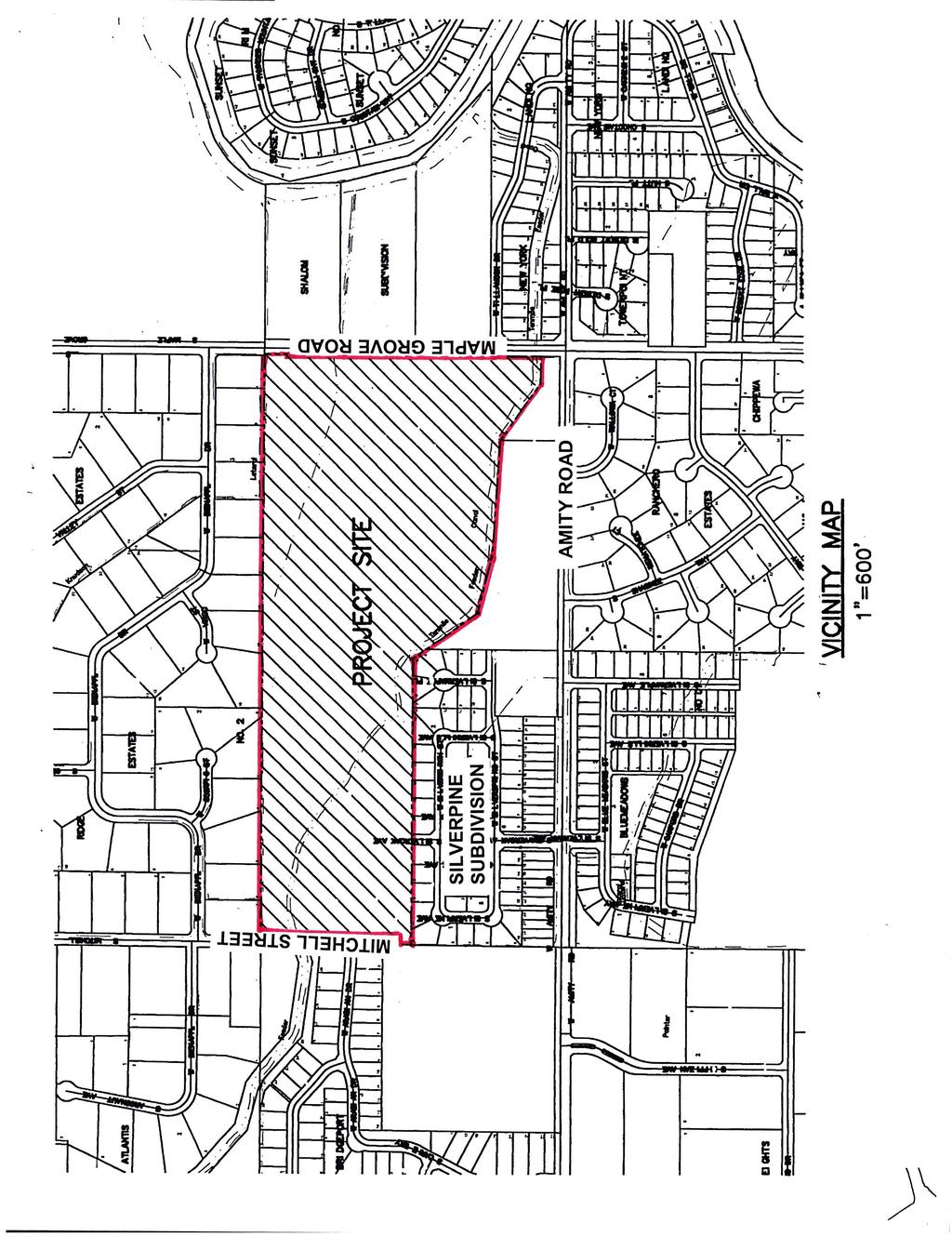
1 Amended Subdivision Staff Report Subdivision Name Silverpine Subdivision File Number SUB No.2 Approval Preliminary Plat Lead Agency Ada County Annexation Date NA Comp. Plan Complies (With Conditions of Approval) Public Hearing Date August 29, 2006 Heard by Boise City Council Analyst David Abo, AICP Description: This is a proposed single family residential subdivision with 157 single-family detached lots, 70 single-family attached lots and 21 common lots on acres. The density of the subdivision is 4.47 dwelling units per acre. The applicant is requesting a rezone from Southwest Community Residential (RSW) to Medium Low Density Residential (R4), Medium High Density Residential (R8), High Density Residential (12) and Very High Density Residential (R20). (See Comprehensive Planning Staff comments) Location: The site is located on the northwest corner of West Amity Road and South Maple Grove Road. Contents: Basis for Recommendation Vicinity Map Preliminary Plat Aerial Map Recommended Conditions of Approval Technical Review and Agency Comments
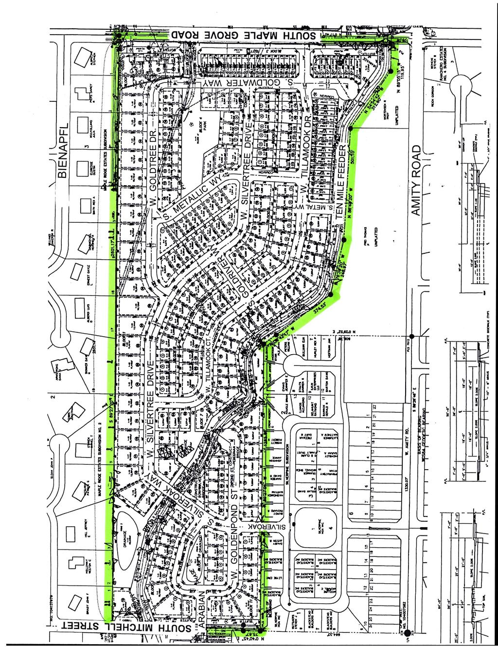
2 2 of 26 Basis for Recommendation The plat design, layout and rezone are in conformance with the Boise City Comprehensive Plan if approved with recommended Conditions of Approval. Condition 1 This condition requires new five foot wide detached sidewalks on South Mitchell Street and South Maple Grove Road as they abut the site. Special note on Sewer Conditions Condition 5 Condition 6 Requires compliance with recommendations of Boise City for connection to Boise City Sewer System. Requires verification of compliance of Boise City recommendations on approved Preliminary Plat prior to sewer plan approval. Staff Perspective General The recommended conditions of approval are required to bring the proposed preliminary plat into compliance with the Boise City Comprehensive Plan as determined by the Boise City Comprehensive Planning Staff. Subdivision Staff has reviewed the agency comments and Staff recommends approval based upon Staff's finding that all concerns of the commenting agencies have been addressed. To avoid potential problems the developer is directed to review the concerns identified in the technical reviews to verify that this statement is correct. The applicant met with Planning Staff after the initial Staff Report was written on August 8, The applicant agreed to changes as recommended by Staff. The preliminary plat was revised and Staff s comments were amended to reflect the changes in the preliminary plat. Street Connectivity: The development is connecting to the existing stub street to the south and is providing two stub streets to the south. There are two east connections to Maple Grove Road and there is one connection to Mitchell Street on the west. Because of the existing development of.7 to 1.1 acre homes to the north no opportunity exists to connect to the north with a road or stub street. The three connections between Tillamook Drive and Silvertree Drive break up the blocks to provide increased connectivity in the subdivision. The Metal Way and Goldwater Way stub streets to the south will allow access when those parcels are developed. Sidewalk:
3 3 of 26 The applicant is proposing public streets and is required to construct five foot attached sidewalks on both sides of all new public streets. The applicant will construct new detached sidewalks on Five Mile Road and Mitchell Street.
4
5
6 DEVELOPMENT FEATURES OWNER HELEN SIMPSON TRUSTEE 4261 S MAPLE GROVE RD BOISE, ID ACREAGE TOTAL PARCEL ACRES TOTAL LOTS BUILDABLE LOTS COMMON LOTS - 20 DENSITY DU/ACRE COMMON AREA - x.xx ACRES US BUREAU OF RECLAMATION 230 COLLINS RD BOISE, ID OWNER ZONING RBR, LLC W. EXECUTIVE DR STE 120 BOISE, ID EXISTING - RSW PROPOSED - R4/R8/R12/R20 SEWAGE DISPOSAL BOISE CITY SEWER DEVELOPER WATER SUPPLY BLD INC W. EXECUTIVE DR STE 120 BOISE, ID UNITED WATER IDAHO CITY BOISE CITY IMPACT AREA SCHOOL DISTRICT ENGINEER BOISE DAVID A. BAILEY, P.E. BAILEY ENGINEERING, INC E IRON EAGLE DR. EAGLE, ID FIRE DISTRICT WHITNEY IRRIGATION DISTRICT NEW YORK IRRIGATION DISTRICT PLANNER/CONTACT KENT BROWN BAILEY ENGINEERING, INC E IRON EAGLE DR. EAGLE, ID LOT SUMMARY TOTAL LOTS SINGLE FAMILY DETACHED SINGLE FAMILY ATTACHED - 41 COMMON LOTS - 20 TOTAL COMMON AREA x.xx ACRES CIVIL ENGINEERING PLANNING CADD 1500 E. IRON EAGLE DRIVE EAGLE, ID TEL FAX

7 Map center: ,
8 4 of 26 Recommended Conditions of Approval 1. Construct new five foot detached sidewalks on South Mitchell Street and South Maple Grove Road as they abut the site. Covenant Requirements 2. Covenants, homeowners association by-laws or other similar deed restrictions acceptable to the Boise City Attorney, which provide for the use, control and maintenance of all common areas, storage facilities, recreational facilities or open spaces shall be reviewed and approved by the Boise City Attorney. Irrigation Conditions 3. Comply with Boise City Code Section J and Idaho Code, Section concerning pressure irrigation requirements prior to signing of the Final Plat by the Boise City Engineer. A. The owner or person, firm or corporation filing the subdivision plat shall provide a pressurized irrigation system. The system must conform to the minimum design standards and specifications of Boise City or of the entity that will operate and maintain the system, if that entity has published standards. Fees: Developer and/or owner shall pay the current inspection and plan review fees on the proposed subdivision prior to signing of the Final Plat by the Boise City Engineer (B.C.C A.2). B. Developer may construct prior to Final Platting or bond in the amount of 110% of the estimated construction costs. C. Prior to either commencing construction or signing of the Final Plat by the Boise City Engineer, developer shall: 1) Submit construction plans and specifications for the pressurized system, stamped by a registered engineer, to the Boise City Public Works Department and acquire approval there from. 2) Provide written assurance that provisions have been made for ownership, operation, and maintenance of the system. 3) Delineate all necessary irrigation easements on the Final Plat (B.C.C F).
9 5 of Developer shall provide for an independent inspection of the installation of irrigation facilities and written certification by the design or project engineer that the system was installed according to the approved plans. In addition, the Boise City Public Works Department must be present for the system pressure test and participate in a final inspection. Sewer Conditions 5. Compliance with all recommendations of the Boise City Council is required for connection to the City of Boise sewer treatment system. 6. Prior to approval of sewer construction drawings by the Boise City Public Works Department, the Preliminary Plat approved by Ada County shall be reviewed and approved for compliance with all the recommendations of the Boise City Council, by the Boise City Subdivision Staff. The Boise City Subdivision Staff shall provide written verification to the Boise City Public Works Department. 7. The developer and/or owner shall delineate all necessary Boise City sanitary sewer easements on the Final Plat prior to signing of the Final Plat by the Boise City Engineer (B.C.C F). 8. Wet line sewers are required (B.C.C D). A. Plans shall be submitted to and approved by the Boise City Public Works Department prior to commencing with construction. Developer/owner may either construct improvements prior to Final Platting or execute a performance agreement and provide surety in the amount of 110% of the estimated costs. The developer shall coordinate with the Public Works Department for construction inspection prior to and during construction. Unless otherwise approved by the Public Works Department, all sewer construction shall be completed and accepted within 90 days of plat recordation or within 30 days of issuance of the first building permit within the subdivision, whichever comes first. NOTE: All bonding shall conform to Boise City Code, Title 8, Chapter 20. B. Developer/owner shall pay the current sewer inspection fees for the proposed subdivision prior to signing of the Final Plat by the Boise City Engineer. C. All lots within this subdivision shall be subject to and restricted by the following recorded subdivision covenants: 1) A monthly sewer charge must be paid after connecting to the Boise City public sewer system, according to the ordinances and laws of Boise City. 2) Owner shall submit to inspection by either the Public Works Department or the Building Department whenever a subdivided lot is to be connected
10 6 of 26 to the City's sewage system and a building is constructed or installed on or within the owner's property. 3) The developer/owner of this subdivision or lot or lots therein shall and hereby does vest in Boise City the right and power to bring all actions against the owner of the premises hereby conveyed or any part thereof for the collection of any charges herein required and to enforce the conditions herein stated. This covenant shall run with the land. 4) The recording of this plat by developer/owner shall be deemed and construed as a request for annexation of its property to the corporate limits of Boise City. Such request and consent shall be binding on all subsequent purchasers or owners of developer's property. 5) Covenants to be approved by the Boise City Attorney. 9. Developer and/or owner shall construct sewer or pay a sewer assessment along Seneca Drive and/or as may be approved by the Boise City Public Works Commission prior to signing of the Final Plat by the Boise City Engineer. Contact the Department of Public Works for specific costs. 10. Developer and/or owner shall pay a connection fee and physically connect to sewer all existing homes to remain within the subdivision boundary prior to signing of the Final Plat by the Boise City Engineer or post bond/agreement for 110% of the cost to connect. NOTE: All bonding shall conform to Boise City Code, Title 9, Chapter 20, Section 8.B.3 which specifies that the improvements to be made shall be done in a time period not to exceed one year from the date of approval of the Final Plat. Street Light Conditions 11. Developer shall delineate on the face of the Final Plat a Boise City street light easement, acceptable to the Boise City Department of Public Works, for the purpose of installing and maintaining city-owned street light fixtures, conduit and wiring lying outside the dedicated public right-of-way (B.C.C F). 12. The developer shall be required to install, at their expense, street lights in accordance with Boise City Public Works specifications and standards at locations designated by the Public Works Department (B.C.C H.1). Plans shall be reviewed and approved by the Boise City Public Works Department prior to commencement of construction, bonding, or payment into trust fund. A. Fees: Developer shall pay the current street light inspection and plan review fees on the proposed subdivision (B.C.C A.2).
11 7 of 26 B. The street lights shall be installed and accepted by the Boise City Public Works Department at the following locations. 24 street lights 25 foot minimum mounting height, 100 W.H.P.S. 4 street lights 30 foot minimum mounting height, 250/400 W.H.P.S. S.W. Corner Lot 8, Block 9 N.W. Corner Lot 12, Block 1 N.E. Corner Lot 7, Block 9 N.E. Corner Lot 5, Block 9 N.E. Corner Lot 1, Block 9 S.E. Corner Lot 4, Block 1 N.W. Corner Lot 82, Block 7 N.E. Corner Lot 90, Block 7 N.E. Corner Lot 80, Block 7 N.E. Corner Lot 71, Block 7 N.E. Corner Lot 66, Block 7 S.E. Corner Lot 50, Block 7 N.E. Corner Lot 46, Block 7 N.E. Corner Lot 43, Block 7 N.W. Corner Lot 25, Block 6 N.E. Corner Lot 33, Block 6 N.E. Corner Lot 1, Block 6 N.E. Corner Lot 1, Block 5 N.E. Corner Lot 17, Block 4 N.E. Corner Lot 36, Block 1 N.W. Corner Lot 1, Block 3 N.E. Corner Lot 36, Block 7 N.E. Corner Lot 23, Block 7 N.E. Corner Lot 11, Block 7 N.E. Corner Lot 1, block 7-30ft. minimum mounting height, 250/400 W.H.P.S. 350 south of the N.E. Corner Lot 1, Block 3-30ft. minimum mounting height, 250/400 W.H.P.S. East end of Island Corner Lot 1, Block 2-30ft. minimum mounting height, 250/400 W.H.P.S. N.E. Corner Lot 41, Block 1-30ft. minimum mounting height, 250/400 W.H.P.S. 13. If bonding approval is granted by the Boise City Public Works Department, developer may bond in the amount of 110% of the estimated street light costs. Street lights shall be installed within 90 days of the issuance of the first building permit in the development, if building permits are obtained prior to completion of street light improvements.
12 8 of 26 General Conditions 14. The developer shall make arrangements to comply with all requirements of the Boise City Fire Department and verify in one of the following ways: A. A letter from the Boise City Fire Department stating that all conditions for water, access, and/or other requirements have been satisfied, OR B. A non-build agreement has been executed and recorded with a note on the face of the Final Plat identifying the instrument number. NOTE: 1) For streets having a width less than 36 feet back of curb to back of curb parking shall be restricted on (1) one side; for streets having a width less than 29 feet back of curb to back of curb parking shall be restricted on both sides; and for standard ACHD cul-de-sacs parking shall be restricted on both sides. A note on the face of the Final Plat is required noting the parking restriction prior to signing of the Final Plat by the Boise City Engineer. 2) "No Parking" signs and curb painting shall be required on streets having a width less than 36-feet, back of curb to back of curb. Contact the Boise City Fire Department for sign placement and spacing. Developer may either construct prior to Final Platting or post bond in the amount of 110% of the estimated costs with the Boise City Planning and Development Services Department. 15. Prior to submitting the Final Plat for recording, the following endorsement or certification must be executed: Certificate of the Boise City Engineer stating, I, the undersigned Boise City Engineer, hereby state that the recommended conditions of Boise City have been satisfied for Silverpine Subdivision No.2. (I.C. Title 50, Chapter 13).
13 9 of 26 Technical Review and Agency Comments Boise City Planning and Development Services: Subdivision Section David Abo, AICP The subdivision must comply with Boise City Comprehensive Plan and conditions of the Boise City Public Works Department. Comprehensive Planning Section Lance Evans, August 17, 2006 This application has been reviewed for consistency with the goals and policies of the Boise City Comprehensive Plan. The subject property is located in the Southwest planning area. The Land Use Map designation is Planned Community. This is an application to rezone acres from RSW (Southwest Community Residential) to Medium Low Density Residential (R4), Medium High Density Residential (R8) and High Density Residential (R12) with a Development Agreement to allow for the platting of 227 residential lots and 21 common lots. The following Land Use Chapter policies have applicability to this application: Chapter 8, Land Use Goal Achieve a city that minimizes suburban sprawl, that provides for a diverse mixture of lifestyles and atmospheres and a sense of place that varies throughout the different areas of the City, and that efficiently provides basic services and facilities in close proximity to where people live. Objective 1) The land-use map and attendant policies shall be the official guide for development of the planning area and shall be implemented through zoning and development review. Policy 1) The Land Use/Zoning Consistency Matrix shall identify the zoning districts that are permissible within each land- use designation. Conformance with the Land Use/Zoning Consistency Matrix shall be a necessary finding of approval for all zone changes and conditional uses, unless one or more of the forms of flexibility identified in the policies under Objective 2 are implemented. Objective 8) The Planned Community land-use designation shall be used to create cohesive developments that contain a combination of land uses, which protect unique landforms and provide creative designs and built environments. Policy 1) Development under the Planned Community land-use designation shall require submittal of a conceptual master plan for approval by the Planning and Zoning Commission
14 10 of 26 prior to submittal of first entitlement. Policy 2) The master plan for any Planned Community area must depict the general location and distribution of land-uses and public facilities, and must demonstrate compliance and consistency with all requirements of the Comprehensive Plan, including any site-specific requirements. Policy 3) Individual entitlement (i.e., Conditional Use, Plat Map) shall be allowed to more precisely define the location and design of development within the master plan, provided that the general intent of the master plan is adhered to. Policy 5) Existing City zoning districts, the alternative New Urbanism code, or specific plans may be used to implement the Planned Community land-use designation and master plan. Objective 13) Land-use and development policies specific to the Southwest shall include the following: Policy 1) Zoning for new regional retail uses shall be prohibited in the Southwest area. New commercial uses shall be of size and design consistent with neighborhood serving facilities. Policy 3) New development in the Southwest shall be set back from existing creeks and drainage swales and shall preserve those areas and attendant riparian habitat as natural open space. Clustering of housing units at higher densities shall be permitted as a means of providing this open space. Public trails shall be provided along creeks, drainage swales and canals where appropriate. Policy 4) Development in the Southwest Planned Community area shall include the following: An urban village shall be developed in the general vicinity of Lake Hazel and Five Mile. This shall include a commercial core of neighborhood-serving uses, including grocery and sundries, dining, medical and dental offices, day care, satellite government offices and similar uses. It shall be of a pedestrian oriented design, in accordance with the standards of New Urbanism. Mixed residential/commercial, townhouses and modular-lot residential uses shall be permitted in and around the urban village. Densities as high as 15 to 20 units per acre may be permitted in the urban village, but may drop to four units per gross acre as development moves out from the urban village core area. In the area east of Five Mile Road, a combination of residential products and densities shall be permitted, ranging from 1 to 25 units per acre. Additional neighborhood-serving commercial facilities may be permitted in this area. Overall developed densities in the Planned Community area may not exceed five to six units per gross acre. Equestrian and pedestrian trails shall be included as an integral part of the Planned Community area, and shall provide connections between the urban village, the golf course to the west and the regional park to the northeast. A master plan for development of the Planned Community area shall be prepared that demonstrates compliance with these principles, prior to first entitlement in the area. Incentives
15 11 of 26 to achieve the New Urbanism designs shall be considered as part of the Master Plan and implementation ordinances. The entire Planned Community area in the Southwest need not be master planned in its entirety at one time, but any master plan must address a minimum of 100 acres. Smaller applications shall also adhere to the land use and design requirements of the Planned Community as identified in this policy, to the extent possible given their size and location. Policy 6) Throughout the Southwest area, particular attention shall be paid to new development to ensure compatibility with existing development including street system interconnections. Policy 7) Open fencing, transitional lot sizes and other design features shall be used to the greatest extent feasible to retain the rural atmosphere of the Southwest area. Policy8) Public parks and other open-space areas shall be encouraged for use as community farms and gardens to preserve the rural heritage of the Southwest. (See Recreation and Cultural Facilities chapter) Analysis of Compliance With Land Use Chapter Policies: This acre development includes 157 detached single family, 70 multi-family attached dwellings in 13 four-plex buildings. The lot sizes range from 2,400 sq. ft. to one 16, 120 sq. ft. lot. The majority of the 157 single family dwelling lots range from 4,000 to 7,000 sq. ft. in size. The developer has provided a good mix of product types and lot sizes in the proposed development. The park site has been modified to provide a more open character and access for the surrounding homes. The pathway connections to the Ten Mile Feeder pathway via Coldwater, Metal, and Tillamook Drives provide adequate pedestrian access for the area. The following Transportation Chapter policies have applicability to this application: Chapter 6.1, Streets Goal Maintain the function of the street system for current users, emergency response efforts and for use by future generations. Objective 3) Encourage completion of the existing street system and creation of new links, within reasonable constraints, as the transportation system develops. Policy 5) New developments shall be required to stub access to adjacent undeveloped parcels, where appropriate. Policy 6) All new development shall be reviewed for appropriate opportunities to connect to local roads and collectors in adjacent developments.
16 12 of 26 Objective 4) Promote land use policies that limit access as necessary to maintain safe and efficient operation of the existing street system while allowing reasonable access to individual development parcels. Policy 1) Support the access restriction policies of the Ada County Highway District. Policy 2) Allow full access to parcels abutting local streets, except where adequate alley access exists to individual lots, in which case new developments shall be encouraged to utilize the alley for access. Policy 3) Discourage direct lot access to parcels abutting collector streets. Policy 4) Limit access to all arterial streets. Analysis of Compliance With Transportation Chapter Policies: The development is connecting to the existing stub street to the south and is providing two stub streets to the south. The east connections will be to Maple Grove Road and there is one connection to Mitchell Street on the west. Because of the existing development of.7 to 1.1 acre homes to the north no opportunity exists to connect to the north with a road. The three connections between Tillamook Drive and Court north to Silvertree Drive break up the blocks to provide increased connectivity in the subdivision. The Metal Way and Goldwater Way stubs to the south will allow access when those parcels are developed. The following Community Quality Chapter policies have applicability to this application: Chapter 7.1, Housing Goal Provide an adequate supply of safe, sanitary housing at price and rent levels appropriate to the varied financial capabilities of City residents, and provide for a diversity in type, density and location of housing with special emphasis on maintaining neighborhood stability. Objective 4) Facilitate development and retention of compatible housing for low and moderateincome households throughout the community. Policy 1) Encourage a mix of housing types, densities and price ranges in residential developments. Chapter 7.2, Community Design Goal Create a community composed of neighborhoods in which services and amenities are convenient, visually pleasing and properly integrated and designed to encourage walking and cycling.
17 13 of 26 Objective 2) Ensure through urban design the development of new residential structures that are functional and aesthetically pleasing. Policy 4) Require that residential street scenes provide variety and modulation in design and placement of homes. Objective 4) Reinforce the development of functional and visually appealing neighborhoods. Policy 1) In order to better connect neighborhoods, require that street configurations involve the interconnection of individual streets. Policy 4) Establish a continuous network of sidewalks, bicycle and/ or pedestrian paths to establish internal and external linkage within the community. Analysis of Compliance With Community Quality Chapter Policies: The plat includes two styles of attached dwelling units configured to front on and provide access to the local street. This will help the city reach goals for attached housing and provide a needed range in housing types and prices in this area. The following Growth Management Chapter policies have applicability to this application: Chapter 10, Growth Management Objective 2) Ensure that development occurs only when adequate public facilities and infrastructure are available and/or financially guaranteed. Policy 1) Development and maintain adequate public services and facilities as defined in Table 2: Level of Service Standards for Community Services and Facilities, for the purpose of capitol improvement programming and development. Policy 4) Where development projects partially meet adequacy of public facilities and service standards, development approval may be authorized for that portion of the project that meets adequacy standards, or the project may be phased to coincide with the phasing of future availability of public facilities and services. Figure 10-1 Level of Service Standards for Concurrence with Development Permit Fire* 4 - Minute response, unless excepted by Fire Department 1.5 Mile service area (Fire Station set-aside shall be required within the City Area of Impact) Water 35 psi residential/1,500 gpm fire flow Sewer - Available to site
18 14 of 26 Schools - System Capacity Streets - Authorization by ACHD Police/Sheriff - Available Solid Waste - Weekly pick-up Electricity - Available Telephone - Available Storm Drainage - Approved on site or public system Figure 10-1 Level of Service Standards for Community Services and Facilities Service Service Standards Service Area TYPE I CONCURRENT WITH THE ISSUANCE OF ANY DEVELOPMENT PERMIT Fire* 4 minute response, unless excepted by Fire Department 1.5 mile Water 35 psi residential/1,500 gpm fire flow Community 40 psi non-residential/1,500 gpm fire flow Community Sewer ** Available to site Community Treatment: Federal Standards + capacity Collection: capacity Schools System capacity Community Streets Authorization by ACHD Community Police/Sheriff Available Solid Waste Weekly pick-up Community Electricity Available Community Telephone Available Community Storm Drainage Approved on site or public system Community * Fire Station set-a-side shall be required within the City Area of Impact. ** See the exception for the Southwest Planning Area identified under Objective 2, Policy 2 in the Sewer Facilities section of the Public Facilities, Utilities and Services chapter of this plan. TYPE II CONCURRENT FIVE YEAR CAPITAL IMPROVEMENT PLAN/OR OTHER LONG- RANGE PLAN*** Service Service Standards Service Area Police Priority 1 3 min. response Community Parks & Neighborhood park = 1.4 acres/1,000 pop. 1/2-mile radius Open Space Community park =.9 acres/1,000 pop. 1-mile radius Large urban park = 1.8 acres/1,000 pop. Community
19 15 of 26 Regional park = 6 acres/1,000 pop. Region Special use areas = 2.4 acres/1,000 pop. Community Natural open space = 8.3 acres/1,000 pop. Community Schools Elementary Schools acres/ students 1/2-mile radius Jr. High acres/1,000 students Multiple neighborhoods High School acres/1,800 2,500 students Multiple neighborhoods Storm drainage Federal standard Community Streets Adherence to the LOS standards adopted in the Community Destination 2020 Regional Transportation Plan for Ada County *** Type II Concurrence in any given service category may be excepted by the service provider for specific sites based on findings that adherence to the adopted standards is undesirable or not intended for the area according to the plans of the service provider. Analysis of Compliance With Growth Management Chapter Policies: Summary of Comprehensive Plan Review Does project comply with Land Use Policies? Yes Does project comply with Pathway Policies? Yes Does project comply with Street Policies? Yes Staff Recommendation Approval Boise City Public Works: Engineering Rob Bousfield No special comments. Pressure Irrigation - Kent Johnson Comply with Boise City Code Section J and Idaho Code, Section Sewer - John Johnson, June 13, 2006 Wet line sewers are required. Sewer inspection fees required. Sewer easements required. Street Lights - Henry Alarcon, June 7, street lights required. Boise City street light easement(s) required. Boise City Airport Matt D. Petaja, Deputy Director, Engineering and Facilities, June 12, 2006 Boise Airport Staff would like to go on record as opposing a zoning change from RSW to the densities mentioned on the application.
20 16 of 26 The project is located adjacent to Airport Influence Area A, which is affected by average sound levels in the DNL and/or aircraft traffic patterns below 1,000 feet. New residential development and new schools are required to provide a sound level reduction of 25 DB. Although we have no regulatory authority over this area, neighbors in this area complain of overflights, which have historically been occurring for 60 years. We graciously request an avigation easement. The Airport also recommends: the avigation easement and developer s proposed marketing disclosure statement be recorded on the subdivision plat sound attenuation standards of a minimum noise level reduction (NLR) of 25 db that the Covenants, Conditions and Restrictions contain provisions addressing the following: - that the Marketing Disclosure Statement (see attachment) be presented to potential buyers (each and every time the property is shown) in perpetuity; - that the Right to Conduct Activities Acknowledgement (see attachment) be included and signed off at all closings in perpetuity; - and that the Marketing Disclosure Statement and Right to conduct Activities Acknowledgement be included in all Covenants, Conditions and Restrictions for the subdivision. Boise City Fire Department - David Miller, June 9, 2006 The Boise Fire Department has reviewed this application and can approve the Preliminary Plat with the following conditions. Any deviation from this plan is subject to Fire Department approval. Specific Requirement: Fire Department vehicular access shall be provided to within 150' of all portions of the nonsprinklered buildings. This distance can be increased somewhat for sprinklered buildings but exact distances are on a case-by-case basis. All Fire Department access roads, fire lanes, bridges, and gates are to be a minimum of 20' wide with 13' 6" overhead clearance, shall be capable of supporting 70,000 lbs GVW (24,000 lbs per axle), and shall be paved. Fire Department access roads and fire lanes shall have a minimum outside turning radius of 48' with an inside radius of 28'. Any dead-end road in excess of 150' needs a Fire Department approved turnaround. No grade may exceed 10% (please note that fire apparatus are designed for a maximum 6% grade). Dead end roads are prohibited from exceeding 700 feet. Width and turning radius measurements specified by this paragraph can include those surfaces vehicles generally drive upon. Specifically, gutter and rolled curb are generally considered useable, while vertical curb or sidewalks are not. Specific Requirement:
21 17 of 26 For streets having a width less than 36 feet back of curb to back of curb parking shall be restricted on (1) one side; for streets having a width less than 29 feet back of curb to back of curb parking shall be restricted on both sides; and for standard ACHD cul-de-sacs parking shall be restricted on both sides. A note on the face of the Final Plat is required noting the parking restriction prior to signing of the Final Plat by the Boise City Engineer. Specific Condition: Streets must be marked accordingly. Specific Requirement: Maximum hydrant spacing for this project is 500 feet between hydrants. Specific Condition: Hydrants noted on the Preliminary appear to be adequate. However, we reserve the right to modify requirements as more information comes to light. Variables affecting hydrant numbers and location include, but are not limited to, area, construction type, existing hydrants, accuracy of information provided in the application, strategic location for fire fighting forces, and required fire flow. New hydrants must be "non-private" installations. General Requirement: Fire Department required fire hydrants, access, and street identification shall be installed prior to construction or storage of combustible materials on site. Provisions may be made for temporary access and identification measures. Specific building construction requirements of the International Building Code, International Fire Code, and Boise City Code will apply. However, these provisions are best addressed by a licensed Architect at building permit application. Please feel free to have the applicant contact David S. Miller, Ada County Highway District Mindy Wallace, July 26, 2006 A. Findings of Fact Existing Conditions 1. Site Information: The site currently contains two dwelling units and associated out buildings. 2. Description of Adjacent Surrounding Area: Direction Land Use Zoning North Maple Ridge Estates No. 2 R-1 South Southwest Community Residential Zone RSW
22 18 of 26 East Silver Pine Subdivision R-8 West Bridgeport Subdivision R-6 3. Existing Roadway Improvements and Right-of-Way Adjacent To and Near the Site S. Maple Grove is currently improved with 2 traffic lanes, and no curb gutter or sidewalk abutting the site. There is 64-feet of right-of-way existing for S. Maple Grove (32-feet from centerline). Mitchell is currently improved with 2 traffic lanes, and no curb, gutter or sidewalk abutting the site. There is 50-feet of right-of-way existing for Mitchell (25-feet from centerline). Amity Road is currently improved with 2 traffic lanes, and no curb, gutter, or sidewalk abutting the site. There is 65 feet of right-of-way existing for Amity Road (32.5 from centerline). 4. Existing Access: There are currently three defined access points to this property off of S. Maple Grove. 5. Site History: ACHD has not previously reviewed this site for a development application. Development Impacts 6. Trip Generation: This development is estimated to generate 1,973 additional vehicle trips per day based on the submitted traffic impact study. 7. Impact Fees: There will be an impact fee that is assessed and due prior to issuance of any building permits. The assessed impact fee will be based on the impact fee ordinance that is in effect at that time. 8. Impacted Roadways:
23 19 of 26 Roadway Frontage Functional Classification Traffic Count Maple Grove 1,200 Minor Arterial 11,572 north of Amity Road on 8/23/05 Level of Service* Better than C Speed Limit 35 MPH Mitchell 660 Major Collector 12,879 south of Victory Road on 8/23/05 1,111 south of Victory Road on 8/23/05 Better than C 50 MPH Amity Road N/A Major Collector 8/30/05 *Acceptable level of service for a two-lane minor arterial roadway is D (14,000 VTD). *Acceptable level of service for a two-lane major collector roadway is D (9,500 VTD). 9. Capital Improvements Plan/Five Year Work Program Maple Grove between Overland Road and Victory Road is scheduled for pedestrian improvement in 2008, and Five Mile Road between Victory Road and Amity Road is scheduled for pedestrian improvements in 2009 as part of the District s Five Year Work Plan. Maple Grove is schedule to be widened to three lanes between Victory Road and Amity Road in 16 to 20 years as part of the District s Capital Improvements Plan. B. Findings for Consideration 4,677 east of Five Mile Road on Better than C 50 MPH 1. Traffic Impact Study The Washington Group International prepared a traffic study for Silverpine Subdivision No. 2. Below is an executive summary of the findings. The proposed development is projected to generate an average daily traffic (ADT) volume of 1,973. As a result of the site build-out traffic in the vicinity is expected to increase. Traffic on Maple Grove Road may increase by 1,874 trips per day north of the project site. Traffic on Amity Road may increase by only 25 trips per day. The intersection of Maple Grove Road and Amity Road is currently a two-way stop with stop signs on the Amity Road approaches. Each approach has only a single lane. There are not added turn lanes at this intersection.
24 20 of 26 The intersection currently operates at LOS A in the PM Peak hour for the existing Maple Grove Road traffic volumes. Amity Road traffic has a stop sign and experiences an LOS of D during the PM peak hour. For the background year 2011 condition (e.g. regional growth), the intersection is predicted to operate at LOS B in the PM peak hour for the existing Maple Grove Road traffic volumes. Amity Road traffic has a stop sign and experiences a LOS of F during the PM peak hour. For the build out year 2011 condition (e.g. regional growth), the intersection is predicted to operate at LOS B in the PM peak hour for the existing Maple Grove Road traffic volumes. Amity Road traffic has a stop sign and experiences a LOS of F during the PM peak hour. The north site access approach with Maple Grove Road is predicted to operate at LOS E during the PM peak hour. The through traffic on Maple Grove has no traffic control and therefore no delay. LOS E is acceptable for minor street approaches to an arterial roadway. The low LOS affects only 40 vehicles per hour. Based on commonly accepted guidelines, a northbound left-turn lane is not required at this site access. However, a southbound taper is needed to facilitate the right-turning traffic. The south site access approach with Maple Grove Road is predicted to operate at LOS E during the PM peak hour. The through traffic on Maple Grove has no traffic control and therefore no delay. LOS E is acceptable for minor street approaches to an arterial roadway. The low LOS affects only 40 vehicles per hour. Based on commonly accepted guidelines, a northbound left turn lane is not required at this site. However, a southbound taper is needed to facilitate the rightturning traffic. The forecast daily build-out volumes for the 2011 build out conditions for all roadways except Maple Grove are lower than COMPASS thresholds. Maple Grove has estimated ATD above the COMPASS threshold. Internally, all of the subdivision s streets with front-on housing have projected ADT volumes less than 1,000 vehicle trips per day. Staff Comment/Recommendations: Staff comments were provided by the District s Traffic Department after receiving the applicant s traffic study. The bridge just north of Amity Road on Maple Grove Road is narrow and will need to be widened.
25 21 of 26 Note: Staff is currently waiting for updated information on the condition and future reconstruction of the Ten Mile Feeder Canal Bridge on S. Maple Grove Road located approximately 250-feet from the Amity Road/S. Maple Grove Road intersection. At a minimum pedestrian improvements will be required. Additional improvement may be required as staff acquires more information on the bridge. Even though they are in alignment with Tillamook on the east, it may be better if they shifted their entrance off Maple Grove to the north to get further from the Amity/Maple Grove Intersection. ACHD will be installing a temporary signal at Amity/Maple Grove this year. It is not believed that long term improvements to this intersection are needed. 2. Maple Grove Road Right-of-Way Policy: District policy requires 96-feet of right-of-way on arterial roadways (Figure 72-F1B). This right-of-way allows for the construction of a 5-lane roadway with curb, gutter, 5-foot concrete detached sidewalks and bike lanes. Street Section Policy: District policy 72-F3 requires arterial roadways to be constructed as a 72-foot street section with curb, gutter and 5-foot detached (or 7-foot attached) concrete sidewalk within 96-feet of right-of-way with parking prohibited on both sides of the roadway. Sidewalk Policy: District policy requires 7-foot wide attached (or 5-foot detached) concrete sidewalk on all collector roadways and arterial roadways ( ). Applicant s Proposal: The applicant has proposed to construct a 5-foot detached concrete sidewalk 41-feet from centerline within 48-feet of right-of-way. Staff Comment/Recommendation: The applicant s proposal meets District Policy. 3. Mitchell Street Right-of-Way Policy: District policy requires 70-feet of right-of-way on collector roadways (Figure 72-F1B). This right-of-way width allows for the construction of a 3- lane roadway with curb, gutter, 5-foot wide detached sidewalks and bike lanes. Street Section Policy: District policy states, developments with any buildable lot that is less that 1-acre in size will typically provide streets having a minimum pavement width of 32-feet with curb, gutter and sidewalks. The total street width shall be 36-feet from back-of-curb to back-of-curb. Variations of this width may be allowed, depending on traffic volumes forecast to be generated by the development. Concrete sidewalks shall be a minimum of 5-feet in width unless they are separated from the curb 5-feet or more in which case the sidewalk shall be a minimum of 4-feet in width.
26 22 of 26 Applicant s Proposal: The applicant has proposed to construct half of a 21-foot street section within 30-feet of right-of-way from the northwest corner of the property south to W. Arabian Drive. Further south past W. Arabian Drive a pedestrian path is proposed. Staff Comment/Recommendation: The applicant will be required to construct one-half of a 36-foot street section within 50-feet of right-of-way from the northwest property line south to W. Arabian Drive along Mitchell Street. Mitchell Street is classified as a collector roadway, but because of its existing use to the north of this site a full collector roadway is not needed. Staff feels that a 36-foot street section within 50-feet of right-ofway is consistent with Mitchell Street to the north, and will provide sufficient access to the site. 4. Internal Streets Right-of-Way Policy: District policy and Figure 72-F1A requires 50-feet of right-of-way on local streets. This right-of-way allows for the construction of a 2-lane roadway with curb, gutter and 5-foot wide concrete sidewalks. 36-foot Street Section Policy: District policy states, developments with any buildable lot that is less that 1-acre in size will typically provide streets having a minimum pavement width of 32-feet with curb, gutter and sidewalks. The total street width shall be 36-feet from back-of-curb to back-of-curb. Concrete sidewalks shall be a minimum of 5-feet in width unless they are separated from the curb 5-feet or more in which case the sidewalk shall be a minimum of 4-feet in width. Island Policy: District policy and require islands to be constructed a minimum of 4-feet wide with a minimum area of 100-square feet and designed to safely channel traffic. The roadway on either side of the traffic island should maintain a minimum of a 21-foot street section. District policy also requires any proposed landscape islands/medians within the public right-of-way dedicated by this plat should be owned and maintained by a homeowners association. Notes of this should be required on the Final Plat. The design should be reviewed and approved by ACHD's Development staff. Turnaround Policy: District policy requires turnarounds to be constructed to provide a minimum turning radius of 45-feet. The applicant should also be required to provide a minimum of a 29-foot street section on either side of any proposed center islands within the turnarounds. The medians should be constructed a minimum of 4-feet wide to total a minimum of a 100-square foot area. Applicant Proposal (Internal streets): The applicant is proposing two entrances roads off of Maple Grove. The first, W. Golden Nugget Street is located approximately 300- feet from the north property line. The second, W. Tillamook Drive is located approximately 1,000-feet from the north property line and approximately 320-feet from
27 23 of 26 the S. Maple Grove/Amity intersection. The applicant is proposing to construct the internal streets as 36-foot street sections with curb, gutter, and 5-foot attached concrete sidewalks. The applicant has proposed one center landscape island on W. Golden Nugget Street within the development. The applicant has proposed 21-foot street sections on each side of the proposed island. Staff Comment/Recommendation: Although the applicant s proposal meets District policy, staff would recommend relocating W. Tillamook Drive. As proposed W. Tillamook Drive is proposed to align with existing Tillamook Drive located on the east side of S. Maple Grove. District staff is supportive of the alignment, but because of the increased traffic at the intersection of S. Maple Grove and Amity Road it is recommended that W. Tillamook Road be relocated approximately 200-feet north to align with an existing driveway for Amity United Methodist Church. This would move the street approximately 500-feet north of the intersection. 5. Tree Planters Tree Planter Policy: The District s Tree Planter Width Interim Policy prohibits all trees in planters less than 6-feet in width. In addition to prohibiting trees in planters less than 6-feet in width, the policy requires a minimum planter width of 6-feet for class II tress with the installation of root barriers on both sides of the planter strip or a minimum planter width of 8-feet without the installation of a root barrier. The policy also requires Class I and Class III trees to provide a minimum planter width of 10-feet. 6. Stub Streets Stub Street Policy: District policy states that the street design in a proposed development shall cause no undue hardship to adjoining property. An adequate and convenient access to adjoining property for use in future development may be required. If a street ends at the development boundary, it shall meet the requirements of sub section 7205, non-continuous streets. District policy states that stub streets will be required to provide intra-neighborhood circulation or to provide access to adjoining properties. Stub streets will conform with the requirements described in Section , and , except a temporary cul-de-sac will not be required if the stub street has a length no greater than 150-feet. A sign shall be installed at the terminus of the stub street stating that, "THIS ROAD WILL BE EXTENDED IN THE FUTURE. Applicant Proposal: The applicant has proposed two stub streets to the south, and one two to the west. The stub streets are proposed to be located as follows: First stub street to the south, S. Metal Way, is proposed to be located 900-feet west of S. Maple Grove Road (measured property line to centerline). Second stub street to the south, S. Silveroak Way, is proposed to be located 460-feet east of the west property line (measured property line to centerline). First stub to the west, W. Arabian Drive, is proposed to be located 270-feet north of the south property line (measured property line to centerline).
28 24 of 26 Staff Comment/Recommendation: The first stub street to the south, S. Metal Way will need to continue over the Ten Mile Feeder Canal when the property to the south redevelops. Because the applicant s property line continues over the canal and ends on the other side the applicant will be required to pay for entire canal crossing. The applicant will need to provide design and cost estimates for the construction of the crossing to District staff. The applicant will then be required to road trust funds for the construction of the crossing and for curb, gutter, and sidewalk on both sides of the crossing. The applicant should coordinate with Development Review staff in regards to the design of the crossing. S. Silveroak way should align with the previously approved stub street, S. Silveroak Avenue, within Silver Pine Subdivision, located to the south of this site. W. Arabian Drive should align with the existing W. Arabian Drive located west of Mitchell Street. 7. Bridge for Ten Mile Feeder Canal Crossing The District will require that the applicant submit the bridge plans for the crossing of the Ten Mile Feeder Canal (S. Silveroak Way) for review and approval prior to the preconstruction meeting and plat approval. 8. Other Access S. Maple Grove Road is classified as minor arterial roadway and Mitchell Street is classified as a collector roadway. Other than the access specifically approved with this application, direct lot access is prohibited to these roadways and should be noted on the Final Plat. C. Site Specific Conditions of Approval 1. Dedicate 48-feet of right-of-way from the center line on S Maple Grove Road. Construct a 5-foot detached concrete sidewalk located 41-feet from center line in its ultimate location. 2. Dedicate 25-feet of right-of-way from center line on Mitchell Street. Construct one-half of a 36-foot street section with curb, gutter, and 5-foot attached concrete sidewalk. 3. Construct all internal streets as a 36-foot street section with rolled curb, gutter, and 5-foot attached concrete sidewalk as proposed. Provide 21-foot street sections on each side of any center islands. Any proposed landscape islands/medians within public right-of-way dedicated by this plat should be owned and maintained by a homeowners association. Notes of this will be required on the Final Plat. The design shall be reviewed and approved by ACHD s Development Staff. Construct turnarounds to provide a minimum turning radius of 45-feet.
Subdivision Staff Report
 Subdivision Staff Report Name: Brownstone Subdivision Date: May 12, 2004 File: SUB04-00041 Meeting: May 18, 2004 Approval: Preliminary To: City Council Lead Agency: Ada County (04-10-S) From: Richard Beck
Subdivision Staff Report
 Subdivision Staff Report Subdivision Name Sunnyridge Subdivision File Number SUB07-00007 Approval Preliminary Plat Lead Agency Ada County Annexation Date NA Comp. Plan Complies (With Conditions of Approval)
Subdivision Staff Report
 Subdivision Staff Report Name: Madronawood Subdivision Date: January 26, 2005 File: SUB05-00005 Meeting: February 1, 2005 Approval: Preliminary To: City Council Lead Agency: Ada County (04-31-S) From:
Subdivision Staff Report
 Subdivision Staff Report Subdivision Name Coldstream File Number SUB06-00040 Subdivision Approval Preliminary Plat Lead Agency Boise City Annexation Date December 9, 1974 Comp. Plan Complies Public Hearing
Time Extension Staff Report
 Time Extension Staff Report Subdivision Name Lunara Subdivision File Number SUB07-00019 Approval Time Extension for Lead Agency Boise City Certification Signature of Boise City Engineer Annexation Date
Subdivision Staff Report
 Subdivision Staff Report Subdivision Name Toli Park Subdivision File Number SUB07-00035 Approval Preliminary Plat Lead Agency Boise City Annexation Date December 30, 1987 Comp. Plan Complies Public Hearing
Subdivision Staff Report
 Subdivision Staff Report Subdivision Name Honeymoon Cove Subdivision File Number SUB08-00005 Approval Preliminary/ Final Plat Lead Agency Boise City Annexation Date December 30, 2004 Comp. Plan Complies
Let me know if I need to bring you any other documentation for this withdrawl. Thanks!
 >>> david benoit 11/27/2007 10:00 AM >>> Dave, I am set to be heard on the Cranston Corner Subdivision on December 4th in front of City council. I have sold this property and am requesting
Subdivision Staff Report
 Subdivision Staff Report Subdivision Name Madera Creek File Number SUB06-00068 Subdivision Approval Final Plat Lead Agency Boise City Annexation Date December 9, 1974 Comp. Plan Complies Public Hearing
Subdivision Staff Report
 Subdivision Staff Report Subdivision Name Birmingham Place File Number SUB06-00051 Subdivision Approval Preliminary/Final Plat Lead Agency Boise City Annexation Date December 3, 1962 Comp. Plan Complies
Time Extension Staff Report
 Time Extension Staff Report Subdivision Name Therrin Subdivision File Number SUB06-00020 Approval Time Extension for Lead Agency Boise City Certification Signature of Boise City Engineer Annexation Date
RE: CAR / 4280 N.
 MEMORANDUM TO: FROM: Mayor and Boise City Council Hal Simmons - Planning Director Boise City Planning and Development Services DATE: April 29, 2009 RE: CAR09-00006 / 4280 N. Eagle Road The following application
Hal Simmons Planning Director Boise City Planning and Development Services. CAR / 1689 South Entertainment Avenue
 MEMORANDUM MEMO TO: FROM: Mayor and Boise City Council Hal Simmons Planning Director Boise City Planning and Development Services DATE: November 15, 2008 RE: CAR08-00019 / 1689 South Entertainment Avenue
SECTION 7000 LAND DEVELOPMENT REQUIREMENTS
 SECTION 7000 LAND DEVELOPMENT REQUIREMENTS 7000 LAND DEVELOPMENT REQUIREMENTS... 1 7001 LEGISLATIVE AUTHORITY... 1 7001.1 LAND DEVELOPMENT... 1 7001.1.1 Title 40, Idaho Code... 1 7001.1.2 Idaho Code 40-1415
Subdivision Staff Report
 Subdivision Staff Report Subdivision Name Greenfield Park File Number SUB06-00110 Subdivision Approval Preliminary/Final Plat Lead Agency Boise City Annexation Date December 9, 1974 Comp. Plan Complies
Date: March 16, Jake Centers ERD, LLC P.O. Box 1610 Eagle, ID Elevation Ridge Subdivision (SUB & PUD ) Street Address
 Street Address") Rebecca W. Arnold, President Sara M. Baker, Vice President John S. Franden, Commissioner Carol A. McKee, Commissioner David L. Case, Commissioner Date: March 16, 2012 To: Jake Centers ERD, LLC P.O. Box
Rebecca W. Arnold, President Sara M. Baker, Vice President John S. Franden, Commissioner Carol A. McKee, Commissioner David L. Case, Commissioner Date: March 16, 2012 To: Jake Centers ERD, LLC P.O. Box
Location: The subject property is located at the northeast corner of S. Holden Lane and E. Boise Avenue.
 Subdivision Staff Report Subdivision Name Tianna Park File Number SUB11-00008 Approval Preliminary Plat Lead Agency Boise City Annexation Date December 19, 1977 Comp. Plan Complies Public Meeting Date
a. provide for the continuation of collector streets and thoroughfare streets between adjacent subdivisions;
 Section 7.07. Intent The requirements of this Section are intended to provide for the orderly growth of the Town of Holly Springs and its extra-territorial jurisdiction by establishing guidelines for:
Executive Summary: This is a preliminary plat to construct 8 residential lots and 2 commons lots with a private road on 3.87-acres in Meridian, Idaho.
 Development Services Department DATE: July 7, 2015 TO: FROM: SUBJECT: ACHD Board of Commissioners Stacey Yarrington, Planner III Kentucky Villas/ MPP15-0012/ PP15-009 Executive Summary: This is a preliminary
Committed to Service
 Committed to Service Paul Woods, President Rebecca W. Arnold, Vice President Sara M. Baker, Commissioner Jim D. Hansen, Commissioner Kent Goldthorpe, Commissioner August 25, 2017 Development Services TO:
Committed to Service
 Committed to Service Sara M. Baker, President Rebecca W. Arnold, Vice President Jim D. Hansen, Commissioner Kent Goldthorpe, Commissioner Paul Woods, Commissioner January 16, 2018 Development Services
The following application has been scheduled for hearing by the Boise City Council on February 15, 2011:
 MEMORANDUM TO: FROM: Mayor and City Council David Abo, AICP Chief Subdivision Review Analyst Boise City Planning and Development Services DATE: February 8, 2011 The following application has been scheduled
May 21, ACHD Board of Commissioners Stacey Yarrington, Planner II DRH /DRH
 Development Services Department May 21, 2013 TO: FROM: SUBJECT: ACHD Board of Commissioners Stacey Yarrington, Planner II DRH13-00106/DRH13-00108 Executive Summary: This is a design review application
#1 (CAR /SUB )
") Development Services Department Project/File: Lead Agency: Site address: Fork South #1 (CAR14-00009/SUB14-00024) The applicant is requesting annexation, rezone and preliminary plat approvals for a 52-lot
Development Services Department Project/File: Lead Agency: Site address: Fork South #1 (CAR14-00009/SUB14-00024) The applicant is requesting annexation, rezone and preliminary plat approvals for a 52-lot
Committed to Service
 Committed to Service Kent Goldthorpe, President Paul Woods, Vice President Rebecca W. Arnold, Commissioner Sara M. Baker, Commissioner Jim D. Hansen, Commissioner July 18, 2016 Development Services TO:
BOI / DRH Albertsons grocery market and fueling center & pad sites
 Paul Woods, President Rebecca W. Arnold, Vice President Sara M. Baker, Commissioner Jim D. Hansen, Commissioner Kent Goldthorpe, Commissioner March 28, 2017 To: Mark Palmer Albertsons Companies 250 E.
WRITTEN DECISION OF THE HAYDEN CITY COUNCIL REGARDING MAPLE GROVE PRELIMINARY SUBDIVISION APPLICATION (SUB-0013) HAYDEN SIGNATURE, LLC
 HAYDEN SIGNATURE, LLC") WRITTEN DECISION OF THE HAYDEN CITY COUNCIL REGARDING MAPLE GROVE PRELIMINARY SUBDIVISION APPLICATION (SUB-0013) HAYDEN SIGNATURE, LLC Application of Hayden Signature, LLC, an Idaho limited liability company,
WRITTEN DECISION OF THE HAYDEN CITY COUNCIL REGARDING MAPLE GROVE PRELIMINARY SUBDIVISION APPLICATION (SUB-0013) HAYDEN SIGNATURE, LLC Application of Hayden Signature, LLC, an Idaho limited liability company,
ARTICLE 23 CONDOMINIUM STANDARDS
 ARTICLE 23 CONDOMINIUM STANDARDS Section 23.01 Intent. The intent of this Article is to provide regulatory standards for condominiums and site condominiums similar to those required for projects developed
SUB /CAR /PUD
 Development Services Department Project/File: Lead Agency: Site address: Balntyre Court Subdivision/BPP16-0036/ SUB16-00066/CAR16-00035/PUD16-00040 This is a rezone, planned unit development, and subdivision
SUB / Diamante Subdivision / Northside Management
 SU15-00062 / Diamante Subdivision / Northside Management Summary: Subdivision application for a Preliminary Plat consisting of 20 buildable lots and 3 common lots. Prepared y: Todd Tucker, Senior Planner
Section Preliminary Plat Checklist and Application Forms
 Section 201 - Preliminary Plat Checklist and Application Forms PRELIMINARY SUBDIVISION PLAT REVIEW PROCESS CHART PRELIMINARY SUBDIVISION PLAT APPLICATION PRELIMINARY PLAT REVIEW CHECKLIST CITY OF NAMPA
PLANNED DEVELOPMENT DISTRICT STANDARDS. Cadence Site
 PLANNED DEVELOPMENT DISTRICT STANDARDS Cadence Site A Planned Development District 1. Statement of General Facts, Conditions and Objectives Property Size: Approximately 57.51 Acres York County Tax Map
Right-of-Way & Development Services Planning Review Division Committed to Service This application is approved at the staff level on February 1, 2006.
 Right-of-Way & Development Services Planning Review Division Committed to Service This application is approved at the staff level on February 1, 2006. Tech Review for this item was held with the applicant
INTEROFFICE MEMORANDUM
 INTEROFFICE MEMORANDUM DATE: February 3, 2009 TO: Public Works Commission FROM: Mike Sheppard, P.E, Civil Engineer SUBJECT: Appeal of Boise City Public Works Denial of Request for an Alternative Sewer
3. The preliminary plats were approved on March 27, 2014 and August 14, 2014.
 Jim D. Hansen, President Sara M. Baker, Vice President Rebecca W. Arnold, Commissioner Kent Goldthorpe, Commissioner Paul Woods, Commissioner February 12, 2015 Development Services Department To: From:
Draft Model Access Management Overlay Ordinance
 Draft Model Access Management Overlay Ordinance This model was developed using the City of Hutchinson and the Trunk Highway 7 corridor. The basic provisions of this model may be adopted by any jurisdiction
SUBDIVISION DESIGN PRINCIPLES AND STANDARDS
 SECTION 15-200 SUBDIVISION DESIGN PRINCIPLES AND STANDARDS 15-201 STREET DESIGN PRINCIPLES 15-201.01 Streets shall generally conform to the collector and major street plan adopted by the Planning Commission
ARTICLE 15 - PLANNED UNIT DEVELOPMENT
 Section 15.1 - Intent. ARTICLE 15 - PLANNED UNIT DEVELOPMENT A PUD, or Planned Unit Development, is not a District per se, but rather a set of standards that may be applied to a development type. The Planned
Date: August 29, Dave Scaggs (sent via ) Summit Development Inc th Ave. Rd. #384 Nampa, ID 83686
 Summit Development Inc th Ave. Rd. #384 Nampa, ID 83686") Sara M. Baker, President John S. Franden, Vice President Rebecca W. Arnold, Commissioner Mitchell A. Jaurena, Commissioner Jim Hansen, Commissioner Date: August 29, 2013 To: Dave Scaggs (sent via email)
Sara M. Baker, President John S. Franden, Vice President Rebecca W. Arnold, Commissioner Mitchell A. Jaurena, Commissioner Jim Hansen, Commissioner Date: August 29, 2013 To: Dave Scaggs (sent via email)
If you have any questions, please feel free to contact me at (208)
") Sara M. Baker, President John S. Franden, Vice President Rebecca W. Arnold, Commissioner Mitchell A. Jaurena, Commissioner Jim Hansen, Commissioner Date: March 21, 2013 To: Subject: Hornet Construction
Sara M. Baker, President John S. Franden, Vice President Rebecca W. Arnold, Commissioner Mitchell A. Jaurena, Commissioner Jim Hansen, Commissioner Date: March 21, 2013 To: Subject: Hornet Construction
M-43 CORRIDOR OVERLAY ZONE
 ARTICLE 26.00 M-43 CORRIDOR OVERLAY ZONE Section 26.01 Findings A primary function of the M-43 state highway is to move traffic through the Township and to points beyond. As the primary east-west arterial
Appendix A. Definitions
 Definitions 1. Terms Defined. Words contained in this are those having a special meaning relative to the purposes of this Ordinance. Words not listed in this section shall be defined by reference to: (1)
Public Facilities and Finance Element
 This Element of the General Plan addresses the following public facilities issues: Water Service, including both potable (drinkable) and non-potable water delivery. Sewer Service, and Financing and construction
Subdivision Staff Report
 Subdivision Staff Report Subdivision Name Athletic Subdivision File Number SUB08-00023 Approval Preliminary/ Final Plat Lead Agency Boise City Annexation Date July 30, 1984 Comp. Plan Complies Public Hearing
Committed to Service
 Development Services Department Committed to Service June 23, 2015 TO: FROM: SUBJECT: ACHD Board of Commissioners Mindy Wallace, AICP Planner III Linder Apartments - EAG15-0005/ CPA-01-15/A-01-15/RZ-04-15
TOWN OF LEWISTON PLANNING BOARD APPLICATION
 TOWN OF LEWISTON PLANNING BOARD APPLICATION DESCRIPTION OF PROPOSED REQUEST: Name of Property Owner: Phone #: Name of Applicant:Phone #: Address or Location of Proposal:_SBL# Size of Parcel or Structure:Existing
ARTICLE VI. SUBDIVISION STANDARDS, PUBLIC
 ARTICLE VI. SUBDIVISION STANDARDS, PUBLIC IMPROVEMENTS, AND DESIGN REQUIREMENTS ARTICLE VI. SUBDIVISION STANDARDS, PUBLIC IMPROVEMENTS, AND DESIGN REQUIREMENTS DIVISION 1. GENERAL PROVISIONS Sec. 21-6100.
CITY OF MERCED SMALL LOT SINGLE-FAMILY HOME DESIGN GUIDELINES
 CITY OF MERCED SMALL LOT SINGLE-FAMILY HOME DESIGN GUIDELINES Development Services Department Planning and Permitting Adopted August 15, 2005 SMALL LOT SINGLE FAMILY HOME GUIDELINES A. Purpose and Applicability.
9. REZONING NO Vicinity of the northwest corner of 143 rd Street and Metcalf Avenue
 9. REZONING NO. 2002-15 Vicinity of the northwest corner of 143 rd Street and Metcalf Avenue 1. APPLICANT: Andrew Schlagel is the applicant for this request. 2. REQUESTED ACTION: The applicant is requesting
Community Development Department 333 Broadalbin Street SW, P.O. Box 490 Albany, OR 97321
 SUMMARY Community Development Department 333 Broadalbin Street SW, P.O. Box 490 Albany, OR 97321 STAFF REPORT Application for Tentative Partition Plat Review Planning File PA-06-17 Phone: 541-917-7550
SOS / Waiver of Subdivision Standards / John Cashin
 SOS15-00012 / Waiver of Subdivision Standards / John Cashin Summary John Cashin requests a Waiver of Subdivision Standards in the Boise Development Code that requires construction of new sidewalk for approval
ARTICLE 15. RULES, REGULATIONS AND DEFINITIONS
 ARTICLE 15. RULES, REGULATIONS AND DEFINITIONS Section 1. Interpretation and Construction: The following rules and regulations regarding interpretation and construction of the Ulysses-Grant County, Kansas,
Chapter 100 Planned Unit Development in Corvallis Urban Fringe
 100.100 Scope and Purpose. Chapter 100 Planned Unit Development in Corvallis Urban Fringe (1) All applications for land divisions in the Urban Residential (UR) and Flood Plain Agriculture (FPA) zones within
ARTICLE V: PUBLIC FACILITIES AND SERVICES V PUBLIC FACILITY AND SERVICE REQUIREMENTS
 ARTICLE V: PUBLIC FACILITIES AND SERVICES V 1 501 PUBLIC FACILITY AND SERVICE REQUIREMENTS 501 1 Intent and Purpose The intent of this Section is to identify those public facilities and services that are
Washington County, Minnesota Ordinances
 Washington County, Minnesota Ordinances Ordinance No. 153 Text Amendment to the Washington County Development Code - Chapter One, Section 2 and Chapter Two, Part 1, Part 2, Part 3, of the Development Code
Cover Letter with Narrative Statement
 Cover Letter with Narrative Statement March 31, 2017 rev July 27, 2017 RE: Rushton Pointe Residential Planned Unit Development Application for Public Hearing for RPUD Rezone PL2015 000 0306 Mr. Eric Johnson,
DIVISION 2 - CONSTRUCTION PLAN AND MISCELLANEOUS REQUIREMENTS
 DIVISION 2 - CONSTRUCTION PLAN AND MISCELLANEOUS REQUIREMENTS 2.1 Required Plan Sheets 2.2 Drawing Requirements 2.3 Graphic Standards 2.4 Easements 2.5 Utility Locations 2.6 Private Facility Locations
TOTTENHAM SECONDARY PLAN
 TOTTENHAM SECONDARY PLAN AMENDMENT NO. 11 TO THE OFFICIAL PLAN OF THE TOWN OF NEW TECUMSETH The following text and schedules to the Official Plan of the Town of New Tecumseth constitute Amendment No. 11
PLANNED UNIT DEVELOPMENT & SUBDIVISION STAFF REPORT Date: April 18, 2019
 PLANNED UNIT DEVELOPMENT & SUBDIVISION STAFF REPORT Date: April 18, 2019 DEVELOPMENT NAME SUBDIVISION NAME Springhill Village Subdivision Springhill Village Subdivision LOCATION 4350, 4354, 4356, 4358,
Subdivision Staff Report
 Subdivision Staff Report Subdivision Name Cayenne Corner File Number SUB06-00060 Subdivision Approval Final Plat Lead Agency Boise City Annexation Date January 1, 1987 Comp. Plan Complies Public Hearing
MAJOR ISSUES DISCUSSED To date, there has been no opposition to this request and no member of the public has testified. ***
 CAR07-00051 Page 2 SUMMARY Larry and Barbara Woolf request approval to rezone ± 1.33 acres from R-1C (Single Family Residential with a maximum of 8.0 DU/acre) to R-2D (Combined Residential with a maximum
FINAL DRAFT 12/1/16, Rev. to 7/18/17
 FINAL DRAFT 12/1/16, Rev. to 7/18/17 (As Adopted 8/8/17 Effective 9/1/17) SHELTON PLANNING AND ZONING COMMISSION Proposed Amendments to Zoning Regulations I. Amend Section 23 PERMITTED USES by inserting
DAUPHIN CREEK ESTATES SUBDIVISION
 # 12 SUB-000076-2017 DAUPHIN CREEK ESTATES SUBDIVISION Engineering Comments: FINAL PLAT COMMENTS (should be addressed prior to submitting the FINAL PLAT for review and/or signature by the City Engineer):
ARTICLE IV: DEVELOPMENT STANDARDS
 ARTICLE IV: DEVELOPMENT STANDARDS IV-53 409 PRIVATE STREETS A private street means any way that provides ingress to, or egress from, property by means of vehicles or other means, or that provides travel
The following information is for use by the Lincoln County Planning Board at their meeting/public hearing on February 3, 2014.
 LINCOLN COUNTY PLANNING & INSPECTIONS DEPARTMENT 302 NORTH ACADEMY STREET, SUITE A, LINCOLNTON, NORTH CAROLINA 28092 704-736-8440 OFFICE 704-736-8434 INSPECTION REQUEST LINE 704-732-9010 FAX To: Planning
1 September 9, 2015 Public Hearing
 1 September 9, 2015 Public Hearing APPLICANT & PROPERTY OWNER: HOLLOMON- BROWN FUNERAL HOME, INC. STAFF PLANNER: Carolyn A.K. Smith REQUEST: Change of Zoning (R-5D Residential District to Conditional O-2
Section 4 Master Plan Framework
 Section 4 Master Plan Framework 4.1 PURPOSE The Master Plan, as an implementation tool of the SPC District, establishes the primary framework for the overall development of the Property. Detailed site
Staff Report: Date: Applicant: Property Identification: Acreage of Request: Current Zoning of Requested Area: Requested Action: Attached:
 Staff Report: Completed by Jeff Palmer Director of Planning & Zoning Date: November 7, 2018, Updated November 20, 2018 Applicant: Greg Smith, Oberer Land Developer agent for Ronald Montgomery ET AL Property
Initial Project Review
 Pierce County Department of Planning and Land Services, 2401 South 35th Street, Tacoma, WA (253) 798-7037 Initial Project Review Major Amendment to Preliminary Plat: Hawks Ridge Division 1 Application
TOOELE COUNTY LAND USE ORDINANCE CHAPTER 31 Page 1
 CHAPTER 31 PLANNED COMMUNITY ZONE (P-C) Section 31-1 Definitions. 31-2 Purpose. 31-3 Land use districts. 31-4 P-C zone area minimum requirements. 31-5 Permitted uses. 31-6 Conditional uses. 31-7 Planning
SECTION 10.7 R-PUD (RESIDENTIAL PLANNED UNIT DEVELOPMENT) ZONE
 ZONE") Article X Zones 10-20 SECTION 10.7 R-PUD (RESIDENTIAL PLANNED UNIT DEVELOPMENT) ZONE A. PURPOSE AND INTENT: The R-PUD Residential PUD Zone is intended to provide alternative, voluntary zoning procedures
Article X Zones 10-20 SECTION 10.7 R-PUD (RESIDENTIAL PLANNED UNIT DEVELOPMENT) ZONE A. PURPOSE AND INTENT: The R-PUD Residential PUD Zone is intended to provide alternative, voluntary zoning procedures
AN ORDINANCE AMENDING THE CODE OF ORDINANCES OF THE TOWN OF TRYON. Chapter 156 Subdivision Ordinance
 AN ORDINANCE AMENDING THE CODE OF ORDINANCES OF THE TOWN OF TRYON Chapter 156 Subdivision Ordinance Chapter 156: Subdivision Regulations ARTICLE I GENERAL PROVISIONS Section 1.1 Title This Ordinance shall
Introduction. General Development Standards
 Introduction The development standards will set the zoning regulations for the East Park development. This section will illustrate lot standards, approximate open space locations and road standards. The
Chapter 7 SITE DEVELOPMENT STANDARDS
 Chapter 7 SITE DEVELOPMENT STANDARDS CHAPTER 7 SITE DEVELOPMENT STANDARDS Section 701 Purpose and Intent The purpose of this Chapter is to establish minimum site requirements for the development and use
Secondary Street Acceptance Requirements Virginia Administrative Code
 Secondary Street Acceptance Requirements Virginia Administrative Code 24VAC30-92-10. Definitions. The following words and terms when used in these regulations shall have the following meanings unless the
Condominium Unit Requirements.
 ARTICLE 19 CONDOMINIUM REGULATIONS Section 19.01 Purpose. The purpose of this Article is to regulate projects that divide real property under a contractual arrangement known as a condominium. New and conversion
Diamond Falls Subdivision PROPOSED YELLOWSTONE COUNTY BOARD OF PLANNING FINDINGS OF FACT
 Diamond Falls Subdivision PROPOSED YELLOWSTONE COUNTY BOARD OF PLANNING FINDINGS OF FACT The City/County Planning Staff has prepared the Findings of Fact for the Diamond Falls Subdivision. These findings
19.12 CLUSTER RESIDENTIAL DISTRICT
 Chapter 19.12 CLUSTER RESIDENTIAL DISTRICT (Adopted 12/22/2003; Ordinance #0061970). Amended 7/3/17, Ordinance #079100. Section 19.12.010 - Declaration of Intent. The Cluster Residential District provides
Article Optional Method Requirements
 Article 59-6. Optional Method Requirements [DIV. 6.1. MPDU DEVELOPMENT IN RURAL RESIDENTIAL AND RESIDENTIAL ZONES Sec. 6.1.1. General Requirements... 6 2 Sec. 6.1.2. General Site and Building Type Mix...
Chapter. Subdivision Regulations Porter County Unified Development Ordinance. website Bradley E.
 Subdivision Regulations Porter County Unified Development Ordinance 2007 Bradley E. Johnson, AICP website www.groundrulesinc.com Conventional Subdivision (CV) 6.01 Conventional Subdivision Intent The Conventional
Chapter Plat Design (LMC)
") Chapter 18.14 Plat Design (LMC) Sections: 18.14.010 Lot width 18.14.020 Right-of-way requirements 18.14.030 Pipe stem lots 18.14.040 Division resulting in minimum lot sizes 18.14.050 Flood prone and bad
Chapter 18.14 Plat Design (LMC) Sections: 18.14.010 Lot width 18.14.020 Right-of-way requirements 18.14.030 Pipe stem lots 18.14.040 Division resulting in minimum lot sizes 18.14.050 Flood prone and bad
MONTGOMERY COUNTY PLANNING DEPARTMENT THE MARYLAND-NATIONAL CAPITAL PARK AND PLANNING COMMISSION
 MONTGOMERY COUNTY PLANNING DEPARTMENT THE MARYLAND-NATIONAL CAPITAL PARK AND PLANNING COMMISSION MCPB Item No.: Date: 06-21-12 The Plantations, Preliminary Plan -120090240 Benjamin Berbert, Senior Planner,
this page left intentionally blank DENVER ZONING CODE
 Article 1. GENERAL PROVISIONS this page left intentionally blank Contents ARTICLE 1. GENERAL PROVISIONS DIVISION 1.1 GENERAL...1.1-1 Section 1.1.1 Purpose...1.1-1 Section 1.1.2 Intent...1.1-1 Section 1.1.3
Section 1: US 19 Overlay District
 Section 1: US 19 Overlay District Section 1.1 Intent and Purpose The purpose of the US Highway 19 Overlay District is to manage access to land development along US Highway 19 in a manner that preserves
Town of Cary, North Carolina Rezoning Staff Report 12-REZ-27 Morris Branch Town Council Public Hearing January 24, 2013
 Town of Cary, North Carolina Rezoning Staff Report 12-REZ-27 Morris Branch Town Council Public Hearing January 24, 2013 REQUEST To amend the Town of Cary Official Zoning Map to rezone approximately 9.0
4 June 11, 2014 Public Hearing
 4 June 11, 2014 Public Hearing APPLICANT: FRANKLIN JOHNSTON MANAGEMENT DEVELOPMENT, L.L.C. PROPERTY OWNER: TRUSTEES OF FIRST LYNNHAVEN BAPTIST CHURCH STAFF PLANNER: Stephen J. White REQUEST: Change of
Committed to Service. License Agreement Application Form
 Committed to Service License Agreement Application Form PLEASE NOTE: Effective February 16, 2010 - License Agreements within the downtown Boise area for public structures, objects and uses on ACHD sidewalks
ARTICLE 3: Zone Districts
 ARTICLE 3: Zone Districts... 3-1 17.3.1: General...3-1 17.3.1.1: Purpose and Intent... 3-1 17.3.2: Districts and Maps...3-1 17.3.2.1: Applicability... 3-1 17.3.2.2: Creation of Districts... 3-1 17.3.2.3:
Committed to Service
 Committed to Service Sara M. Baker, President Rebecca W. Arnold, Vice President Jim D. Hansen, Commissioner Kent Goldthorpe, Commissioner Paul Woods, Commissioner February 28, 2018 Development Services
Draft Zoning Changes for the 2nd Planning Board Public Hearing, January 22, 2018.
 Draft Zoning Changes for the 2nd Planning Board Public Hearing, January 22, 2018. No changes were made at the 1st Public Hearing. Proposed wording for the 1 st Public Hearing in red, eliminated text in
PALM BEACH COUNTY PLANNING, ZONING AND BUILDING DEPARTMENT ZONING DIVISION
 PALM BEACH COUNTY PLANNING, ZONING AND BUILDING DEPARTMENT ZONING DIVISION Application No.: CA-2012-00688 Control No.: 2011-00552 Applicant: Garry Bernardo Owners: Garry Bernardo Agent: Frogner Consulting,
ARTICLE 24 PRIVATE ROAD, SHARED PRIVATE DRIVEWAY AND ACCESS EASEMENT STANDARDS
 ARTICLE 24 PRIVATE ROAD, SHARED PRIVATE DRIVEWAY AND ACCESS EASEMENT STANDARDS SECTION 24.00 INTENT AND PURPOSE The standards of this Article provide for the design, construction and maintenance of private
1 November 13, 2013 Public Hearing APPLICANT & PROPERTY OWNER: HOME ASSOCIATES OF VIRGINIA, INC.
 1 November 13, 2013 Public Hearing APPLICANT & PROPERTY OWNER: HOME ASSOCIATES OF VIRGINIA, INC. STAFF PLANNER: Carolyn A.K. Smith REQUEST: Conditional Change of Zoning (AG-1 & AG-2 Agricultural Districts
Town of Cary, North Carolina Rezoning Staff Report 14-REZ-31 Cary Park PDD Amendment (Waterford II) Town Council Meeting January 15, 2015
 Town Council Meeting January 15, 2015") Town of Cary, North Carolina Rezoning Staff Report 14-REZ-31 Cary Park PDD Amendment (Waterford II) Town Council Meeting January 15, 2015 REQUEST To amend the Town of Cary Official Zoning Map by amending
Town of Cary, North Carolina Rezoning Staff Report 14-REZ-31 Cary Park PDD Amendment (Waterford II) Town Council Meeting January 15, 2015 REQUEST To amend the Town of Cary Official Zoning Map by amending
DEVELOPMENT DEPARTMENT STAFF REPORT THE PARK AT 5 TH
 DEVELOPMENT DEPARTMENT STAFF REPORT ARB Meeting Date: July 3, 2018 Item #: _PZ2018-293_ THE PARK AT 5 TH Request: Site Address: Project Name: Parcel Number: Applicant: Proposed Development: Current Zoning:
City of Grande Prairie Development Services Department
 City of Grande Prairie Development Services Department COUNTRYSIDE SOUTH OUTLINE PLAN Prepared by: GPEC Consulting Ltd. #202, 10712-100th Street Grande Prairie, AB Council Resolution of August 20, 2001
CHAPTER34 PRUD - PLANNED RESIDENTIAL UNIT DEVELOPMENT
 CHAPTER34 PRUD - PLANNED RESIDENTIAL UNIT DEVELOPMENT 17-34-1 17-34-2 17-34-3 17-34-4 17-34-5 17-34-6 17-34-7 17-34-8 17-34-9 Purpose Planned Residential Unit Development Defined Planned Residential Unit
ORDINANCE NO. Be it ordained by the City Council of the City of Abilene, Texas:
 ORDINANCE NO. An ordinance repealing Chapter 23, Subpart B of the Code of the City of Abilene, Texas, entitled Mobile Homes and Vacation Travel Trailers; stating the authority; setting forth the scope
Affordable Housing Plan
 Affordable Housing Plan CORDOVA HILLS SPECIAL PLANNING AREA 1 Proposed Project Conwy LLC is the master developer ( Master Developer ) of that certain real property in the County of Sacramento ( County
AAAA. Planning and Zoning Staff Report Lake Shore Land Holdings, LLC CU-PH Analysis
 AAAA Planning and Zoning Staff Report Lake Shore Land Holdings, LLC CU-PH2016-28 Hearing Date: April 21, 2016 Development Services Department Applicant: BRS Architects/Cindy Huebert Staff: Kyle McCormick,