LOCAL PLANNING AGENCY
|
|
|
- Gabriel Taylor
- 5 years ago
- Views:
Transcription
1 LOCAL PLANNING AGENCY Pinellas County Courthouse - Fifth Floor County Commissioners Assembly Room Clearwater, Florida June 13, :00 A.M. (Wednesday)
2 I. CALL TO ORDER AGENDA LOCAL PLANNING AGENCY Pinellas County Courthouse, Clearwater, FL County Commissioners Assembly Room Fifth Floor June 13, :00 A.M. (WEDNESDAY) II. III. APPROVAL OF MINUTES for the May 9, 2018 LPA Meeting. PUBLIC HEARING ITEM Action by the LPA regarding the following items: A. Proposed Amendment to the Pinellas County Future Land Use Map and Zoning Atlas: 1. Q CU (Vehicle Recovery Services, Inc.) A request for a conditional use to allow a FAA permitted private Helipad, and variances to allow the Touchdown Area to be 37 feet in length and width where 100 feet in length and width are required, and the Primary Surface Area to be 74 feet in length and width where 300 feet in length and width are required on approximately 0.71 acre located at th Street rth in Lealman. 2. Z/LU (Pinellas Auto Sales) A request for a zoning change from, Single Family Residential to, General Retail Commercial & Limited Services (0.32 acre) and -CO, General Retail Commercial & Limited Services Conditional Overlay (0.38 acre) with a conditional overlay limiting the use of the northern 220-foot portion of the property to parking of vehicle inventory only and a land use change from Residential Urban to Commercial General on Approximately 0.70 acre located at 6789 Ulmerton Road (a portion of parcel 06/30/16/70938/400/1302). 3. Z/LU (Bayou Development, Inc.) A request for a zoning change from, Residential Planned Development to -CO, Light Manufacturing and Industry Conditional Overlay with a conditional overlay limiting the uses on the property to self-storage facility and office. Additionally, providing for a 50- foot buffer along the western property line that may be used for drainage retention and a land use from Residential Low to Employment on approximately 4.93 acres located at the northeast corner of Missouri Avenue and 9th Street in Palm Harbor. IV. Adjournment IF YOU ARE A PERSON WITH A DISABILITY WHO NEEDS ANY ACCOMMODATION IN ORDER TO PARTICIPATE IN THIS PROCEEDING, YOU ARE ENTITLED, AT NO COST TO YOU, TO THE PROVISION OF CERTAIN ASSISTANCE. WITHIN TWO (2) WORKING DAYS OF YOUR RECEIPT OF THIS NOTICE PLEASE CONTACT THE OFFICE OF HUMAN RIGHTS, 400 SOUTH FORT HARRISON AVENUE, SUITE 500, CLEARWATER, FLORIDA (727) (VOICE) (727) (V/TDD). KEN BURKE, CLERK TO THE BOARD OF COUNTY COMMISSIONERS By rman Loy, Deputy Clerk
3 AGENDA ITEM II. Approval of Minutes The minutes for the May 9, 2018 meeting are not available at this time. Attachment: Required Action(s) by the LPA:
4 AGENDA ITEM III. A. 1. Case. Q CU A property containing approximately 0.71 acre located at th Street rth in Lealman. Conditional Use to allow a Federal Aviation Administration (FAA) permitted private Helipad, and variances to allow the Touchdown Area to be 37 feet in length and width where 100 feet in length and width are required, and the Primary Surface Area to be 74 feet in length and width where 300 feet in length and width are required


5 LOCAL PLANNING AGENCY (LPA) STAFF REPORT Case Number: CU LPA Public Hearing: June 13, 2018 Applicant: Vehicle Recovery Services, Inc. (insert map Representative: Wayne Parker Subject Property: approximately 0.71 acre located at th Street rth in Lealman PARCEL ID(S): 03/31/16//61722/001/0090 REQUEST: A Conditional Use to allow a Federal Aviation Administration (FAA) permitted private Helipad, and variances to allow the Touchdown Area to be 37 feet in length and width where 100 feet in length and width are required, and the Primary Surface Area to be 74 feet in length and width where 300 feet in length and width are required. LOCAL PLANNING AGENCY (LPA) RECOMMENDATION: PLANNING STAFF RECOMMENDATION: Staff recommends that the LPA find the proposed Conditional Use is consistent with the Pinellas County Comprehensive Plan, based on the Findings of this report. Staff further recommends that the LPA recommend approval of the proposed Conditional Use and variances to the Pinellas County Board of County Commissioners subject to the following conditions, which will apply to the entire parcel associated with the conditional use: 1. Full site plan review. 2. Site development shall maintain substantial conformance with the associated FAA approved helipad plan. 3. Appropriate FAA licensure shall be maintained for the helipad. 4. structures are to be placed in the FAA approved landing path.
6 Page 2 5. Any changes to the conditions listed shall require approval of the appropriate Board at a public hearing. 6. In the event any of the above conditions are not met or the conditional use becomes a nuisance, its approval may be rescinded. SUMMARY REPORT The Planning Review Committee (PRC) reviewed this application on May 14, The PRC Staff summary discussion and analysis follows: The subject property is a 0.71 acre parcel located at the southwest corner of 46 th Avenue rth and 35 th Street rth (address: th Street rth). It is currently the site of a storage facility for historical military vehicles that are used for various special events throughout the Tampa Bay area. There are multiple storage buildings on the property and a helipad. The property is zoned M-2, Heavy Manufacturing & Industry, on the Zoning Atlas and is designated Employment (E) on the Pinellas County Future Land Use Map (FLUM). The conditional use request is for the private helipad on the property. The conditional use is not expected to negatively impact the surrounding area. The helipad received FAA approval in 2013 and has been in use since shortly after that. The FAA approval process is very thorough, including no objection letters from surrounding property owners. A copy of the FAA approved permit has been submitted with this application. The surrounding properties are all industrial uses. The applicant is also requesting a variance to allow the Touchdown Area of the helipad to be 37 feet in length and width where 100 feet in length and width are required, and the Primary Surface Area of the helipad to be 74 feet in length and width where 300 feet in length and width are required. This one-size-fits-all requirement has been in the Pinellas County Land Development Code for decades and is not consistent with current FAA regulations of helipads. Per the FAA, the size of the touchdown area and primary surface area are based on the size of the aircraft that will be utilizing the helipad. As such, the requested reduction to the size requirements of the helipad would not pose any safety hazards to the surrounding area. Staff recommends approval of the proposed conditional use and variances as the request meets the General Standards of Section of the Pinellas County Land Development Code as follows: (staff response is in italic print) 1) All structures and uses shall be separated from adjacent and nearby uses by appropriate screening devices or landscaped open area. (The subject property is surrounded by industrial uses on all sides. Any additional screening/landscaping, if needed, will be determined during site plan review.) 2) Excessive vehicular traffic is not generated on residential streets and no vehicular parking or other traffic problem is created. (The property is not open to the public and access to it does not travel on any residential streets. All required parking will be provided on site, and as such no local street traffic or vehicular parking problem will be created.)
7 Page 3 3) Appropriate drives, walks and parking areas are proposed so that no vehicular traffic or parking problems are created. (The proposed use will meet all parking requirements.) 4) Drainage problems will not be created on the subject property or adjacent properties. (Specific Drainage requirements will be determined during site plan review.) 5) All provisions and requirements of the zoning district in which the project is located will be met. (The proposed use will meet all provisions of the M-2 zoning district, with the exception of the included variance requests.) 6) The conditional use shall be consistent with the county comprehensive plan adopted pursuant to state law and shall be in keeping with the purpose and intent of this chapter. (The proposed use is consistent with the Pinellas County Comprehensive Plan.) 7) In approving a conditional use, the Board of County Commissioners may establish and require additional safeguards to ensure proper operation of the use and provide protection to the surrounding area. Such safeguards may include but are not limited to: a time limit for acquiring development authorization; hours of operation; entry and exit point to and from the site; additional setbacks; fencing and screening; and capacity of use. The Board shall have the authority to grant variances at the hearing. SURROUNDING ZONING AND LAND USE FACTS: Land Use Category Zoning District Existing Use Subject Property: Employment M-2 Storage Buildings Adjacent Properties: rth Employment Warehouse East Employment C-3 Storage South Employment M-2 Industrial Use West Employment M-2 Vacant IMPLEMENTATION OF THE PINELLAS COUNTY COMPREHENSIVE PLAN Staff finds that the proposed amendment is consistent with the following adopted objectives and policies of the Pinellas County Comprehensive Plan: FUTURE LAND USE AND QUALITY COMMUNITIES ELEMENT Objective 1.2 Policy Establish development regulations that respond to the challenges of a mature urban county with established communities that are experiencing infill development and redevelopment activity. The Local Planning Agency (LPA) of the Board shall ensure that zoning provisions within the Land Development Code are in conformance with the density, intensity, and other
8 Page 4 relevant standards contained within the Future Land Use and Quality Communities Element. Policy Policy Plan designations on the Future Land Use Map shall be compatible with the natural environment, support facilities and services, and the land uses in the surrounding area. Conditional uses, when authorized by the Board of County Commissioners after a public hearing, shall be consistent with the Pinellas County Comprehensive Plan. COUNTY DEVELOPMENT REGULATIONS Approval of this request does not ensure that the site can meet County development regulations, including concurrency management regulations, which apply at the time of site plan review. PROPOSED BCC HEARING DATE: July 17, 2018 CORRESPONDENCE RECEIVED TO DATE: correspondence received. The owners of surrounding properties within 500 feet of the subject property were notified by mail. PERSONS APPEARING AT THE LOCAL PLANNING AGENCY HEARING: (Type in correspondence) ATTACHMENTS: (Maps)
9 BELCHER RD US HIGHWAY 19 N BAYSIDE BRIDGE EAST LAKE RD N PINELLAS AVE TRINITY BLVD KEYSTONE RD US 19A CR 611 CURLEW RD TAMPA RD CR 1 EDGEWATER DR MAIN ST SUNSET POINT RD DREW ST COURT ST SR 580 SR 590 GULF TO BAY BLVD COURTNEY CAMPBELL CSWY BELLEAIR RD WEST BAY DR EAST BAY DR I-275 OAKHURST RD 113TH ST N GULF BLVD SEMINOLE BLVD DUHME RD STARKEY RD PARK BLVD N PARK ST N 71ST ST N 66TH ST N ULMERTON RD 118TH AVE N 49TH ST N 54TH AVE N I ND AVE N 38TH AVE N 22ND AVE N DR MARTIN LUTHER KING JR ST N 4TH ST N GANDY BLVD PASADENA AVE S 5TH AVE N I-375 CENTRAL AVE 34TH ST S I-275 I ND AVE S CU GULF BLVD PINELLAS BAYWAY S 54TH AVE S SUNSHINE SKYWAY Surrounding Counties CU Location Map Conditional Use to allow a private helipad, and related variances to allow a 37' x 37' Touchdown Area where 100' x 100' is required and a 74' x 74' Primary Surface Area where 300' x 300' is required. 03/31/16/61722/001/0090 Prepared by: Pinellas County Planning Department N Date: 5/1/ inch = 4.5 miles
10 C-1 P-1 C-1 P-1A C-1 P-1A R-6 C-1 R-6 RM-7.5 R-6 RPD-7.5 M-2 P-C R2.5 RPD-12.5 RPD-12.5 RM-7.5 R-6 R-6 46TH AVE N C-3 C-3 C-3 M-2 C-3 37TH ST N M-2 M-2 M-2 C-3 C-3 CU C-3 M-2 M-2 34TH ST N R-5 C-3 RM-7.5 PGIS.Parcels Zoning - Label Only C-3 Residential Low Residential Urban Residential Low Medium Residential Medium R2.5 35TH ST N R2.5 Commerical General Employment Residential Office Limited Residential Office General Preservation Recreation Open Space Institutional Transportation Utility Water 38TH AVE N Surrounding Counties CU Current Land Use & Zoning 03/31/16/61722/001/0090 Conditional Use to allow a private helipad, and related variances to allow a 37' x 37' Touchdown Area where 100' x 100' is required and a 74' x 74' Primary Surface Area where 300' x 300' is required. Prepared by: Pinellas County Planning Department N Date: 5/1/ inch = 0.12 miles
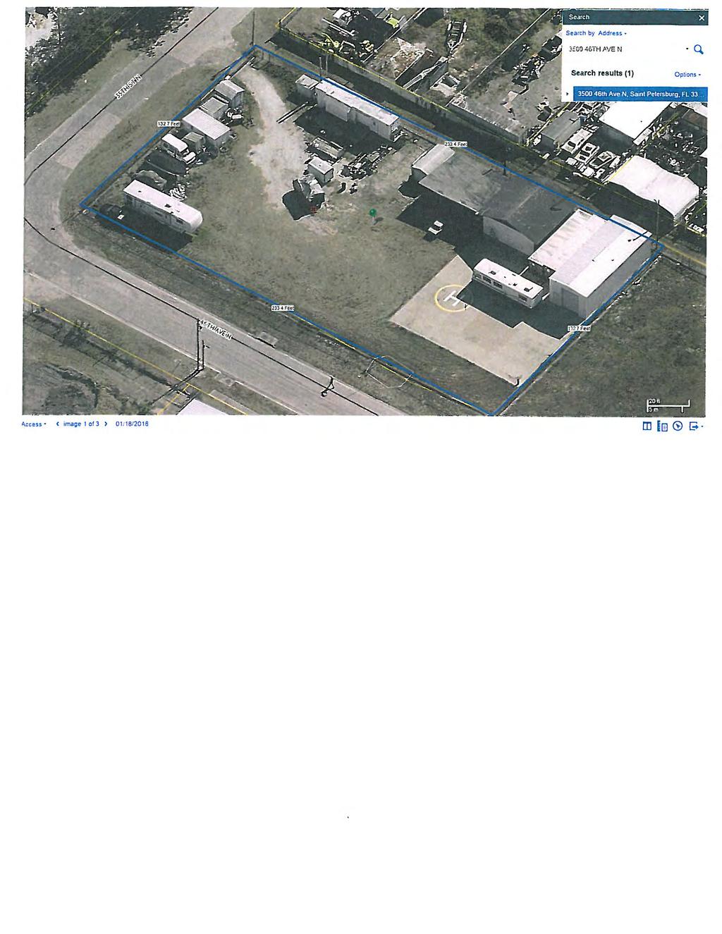
11 37TH ST N 34TH ST N CU TH AVE N M-2 MORRIS ST N 35TH ST N 38TH AVE N CU Aerial Map Conditional Use to allow a private helipad, and related variances to allow a 37' x 37' Touchdown Area where 100' x 100' is required and a 74' x 74' Primary Surface Area where 300' x 300' is required. 03/31/16/61722/001/0090 Prepared by: Pinellas County Planning Department N Date: 5/1/ inch = 0.12 miles
12 C-1 P-1 C-1 P-1A P-1AC-1 R-6 C-1 R-6 RPD-7.5 M-2 P-C R2.5 RPD-12.5 RPD-12.5 C-3 C-3 RM-7.5 R-6 C-3 R-6 C-3 C-3 CU RM-7.5 R-6 M-2 M-2 M-2 M-2 C-3 C-3 R-5 RM-7.5 M-2 M-2 34TH ST N C-3 C-3 R2.5 R2.5 Municipality Name St Petersburg Unincorporated 38TH AVE N CU Municipal Map Conditional Use to allow a private helipad, and related variances to allow a 37' x 37' Touchdown Area where 100' x 100' is required and a 74' x 74' Primary Surface Area where 300' x 300' is required. 03/31/16/61722/001/0090 Prepared by: Pinellas County Planning Department N Date: 5/1/ inch = 0.12 miles
13
14
15
16
17
18
19
20
21 AGENDA ITEM III. A. 2. Case. Z/LU A property containing approximately 0.70 acre located at 6789 Ulmerton Road (a portion of parcel 06/30/16/70938/400/1302). Zone change from:, Single Family Residential to:, General Retail Commercial & Limited Services (0.32 acre) and -CO. General Retail commercial & Limited Services Conditional Overlay (0.38 acre) with a Conditional Overlay limiting the use of the northern 220-foot portion of the property to parking of vehicle inventory only. Land Use change from: Residential Urban to: Commercial General

22 LOCAL PLANNING AGENCY (LPA) STAFF REPORT Case Number: Z/LU LPA Public Hearing: June 13, 2018 Applicant: Pinellas Auto Sales (insert map here) Representative: Aneil Balkissoon Subject Property: Approximately 0.70 acre located at 6789 Ulmerton Road PARCEL ID(S): a portion of parcel 06/30/16/70938/400/1302 REQUEST: Future Land Use Map (FLUM) amendment from Residential Urban (RU) to Commercial General (CG) (0.7 acre) and a Zoning Atlas amendment from (Single Family Residential) to (General Retail Commercial & Limited Services) (0.32 acre) and -CO (General Retail Commercial & Limited Services Conditional Overlay) (0.38 acre), with the Conditional Overlay limiting the use of the northern 220-foot portion of the property to parking of vehicle inventory only. The total amendment area is a 0.7-acre portion of a 1.02-acre parcel located at 6789 Ulmerton Road in unincorporated Largo. This request would allow for the expansion of commercial uses on the property. LOCAL PLANNING AGENCY (LPA) RECOMMENDATION: PLANNING STAFF RECOMMENDATION: Staff recommends that the LPA find the proposed land use and zoning amendments consistent with the Pinellas County Comprehensive Plan, based on this report. Staff further recommends that the LPA recommend approval of the proposed land use and zoning amendments to the Pinellas County Board of County Commissioners.
23 Page 2 SUMMARY REPORT The Planning Review Committee (PRC) reviewed this application on May 14, The PRC Staff summary discussion and analysis follows: The subject area consists of the northern 0.70-acre portion of a larger 1.02-acre parcel located on the north side of Ulmerton Road approximately 130 feet east of Audrey Lane in unincorporated Largo (address: 6789 Ulmerton Road). The subject area itself contains the majority of the larger building and the smaller northern building (which were established as legal nonconforming uses in 2009). The southern portion of the site, already zoned, contains the majority of the overall property that has been utilized in association with an auto sales and repair business. The subject area is designated Residential Urban (RU) on the Future Land Use Map (FLUM) and zoned, Single Family Residential. The portion of the overall property that is south of the subject area adjacent to Ulmerton Road is designated Commercial General (CG) on the FLUM, and zoned. The structures on the property date from the early 1960s and, according to the nonconforming use approval documents, an office has existed on the subject area since at least The parcel itself has unusual size dimensions (75 feet wide by 588 feet deep) and a unique relationship to adjacent uses, which present a challenge in terms of an appropriate compatible use. Staff is of the opinion that the site is not conducive to residential development as ingress and egress to the residential area would be difficult given the narrow size of the property and access needed through and encroaching on an existing commercial use. Staff believes that the extension of the zoning on the parcel for the 0.32 acre portion will correct the nonconforming use that has been operating on the site for over 50 years. Further, the amendment to with a Conditional Overlay on the northern 0.38-acre portion limits this area to a passive commercial use that can be considered compatible with the adjacent residential uses provided proper screening is in place as required by the performance standards in the Pinellas County Land Development Code. The zoning on the southern portion of the parcel fronting Ulmerton Road was established in 1977 (Amended from to ). In 2009 an additional 0.11-acre portion of the parcel was amended from to. The subject site is located in an area that contains a variety of land uses and zoning districts. The property directly to the north of the site contains a 200-foot tall cell phone tower and accessory equipment, to the east are a triplex and a preschool, to the south is the part of the subject property already zoned, and to the west is a truck and car rental company and four single-family homes. The proposed CG FLUM and & -CO zoning designations are appropriate for the subject area. The zoning district has existed on part of the property for decades. The proposed Conditional Overlay would limit utilization of the northern portion of the property to vehicle inventory storage, which is generally a quiet use that generates little traffic and poses limited overall impacts.
24 Page 3 SURROUNDING ZONING AND LAND USE FACTS: Land Use Category Zoning District Existing Use Subject Property: Residential Urban Office for Auto Sales/Repair Adjacent Properties: rth Employment 200-foot Cell Phone Tower East Residential Low Medium & Triplex & Preschool South Commercial General Auto Sales & Repair West Commercial General & Largo, & Largo Single-Family & Auto Rental IMPLEMENTATION OF THE PINELLAS COUNTY COMPREHENSIVE PLAN Staff finds that the proposed amendment is consistent with the following adopted objectives and policies of the Pinellas County Comprehensive Plan: FUTURE LAND USE AND QUALITY COMMUNITIES ELEMENT GOAL ONE: The pattern of land use in Pinellas County shall provide a variety of urban environments to meet the needs of a diverse population and the local economy, conserve and limit demands on natural and economic resources to ensure sustainable built and natural environments, be in the overall public interest, and effectively serve the community and environmental needs of the population. Objective 1.2 Policy Policy Establish development regulations that respond to the challenges of a mature urban county with established communities that are experiencing infill development and redevelopment activity. The Local Planning Agency (LPA) of the Board shall ensure that zoning provisions within the Land Development Code are in conformance with the density, intensity and other relevant standards contained within the Future Land Use and Quality Communities Element. The Board shall implement land development regulations that are compatible with the density, intensity and other relevant standards of those land use categories defined in the Future Land Use and Quality Communities Element. COUNTY DEVELOPMENT REGULATIONS Approval of this request does not ensure that the site can meet County development regulations, including concurrency management regulations, which apply at the time of site plan review. PROPOSED BCC HEARING DATE: July 17, 2018 CORRESPONDENCE RECEIVED TO DATE: correspondence received.
25 Page 4 PERSONS APPEARING AT THE LOCAL PLANNING AGENCY HEARING: (Type in correspondence) ATTACHMENTS: (Maps)
26 Impact Assessment and Background Data for Staff Report Amendment to the Pinellas County Future Land Use Map and Pinellas County Zoning Atlas Map Z/LU: Site Location: N/A Street Address: Located at 6789 Ulmerton Road in unincorporated Largo. Parcel Number: A portion of 06/30/16/70938/400/1302 Prepared by: MDS Date: 5/25/18 Proposed Amendment From: Future Land Use Designation(s): RU acres 0.70 Zoning Designation(s): acres 0.70 Proposed Amendment To: Future Land Use Designation(s): CG acres 0.70 Zoning Designation(s): & -CO acres 0.70 Development Agreement? New Amended Affordable Housing Density Bonus? How many units: Local Planning Agency - Impact Assessment Z/LU
27 INFRASTRUCTURE IMPACTS SOLID WASTE IMPACT ASSESSMENT LAND USE DESIGNATIONS SOLID WASTE Total Tons/Year * EXISTING Residential Urban Currently vacant 0.70 acres x 7.5 dwelling units per acre= 5 single family units 5 x 1.66 tons/unit/year (residential factor) = 8.3 tons/year PROPOSED Commercial General Proposed Vehicle Sales & Service (10,672.2 x 9.2)/2,000 (vehicle sales & service factor)= tons/year NET DIFFERENCE tons/year * (n Residential) Gross Floor Area x Solid Waste Disposal Rate / 2,000 lbs = Total Tons per Year * (Residential) Units x Annual Per Capita Rate = Total Tons per Year te: Based upon Solid Waste Disposal Rate determined by DUS Consultants for the Solid Waste Authority of Palm Beach County. POTABLE WATER AND SANITARY SEWER IMPACT ASSESSMENT LAND USE DESIGNATIONS EXISTING Residential Urban PROPOSED Commercial General POTABLE WATER GPD * 0.70 acres x 7.5 dwelling units per acre= 5 single family units 5 x 266 per unit (residential factor) = 1,330 GPD Proposed Vehicle Sales & Service 10,672.2 x 0.25 (Commercial rate) = 2,668 GPD WASTEWATER GPD* 0.10 acres x 7.5 dwelling units per acre= 5 single family units 5 x per unit (residential factor) = GPD Proposed Vehicle Sales & Service 10,672.2 x 0.25 (Commercial rate) = 2,668 GPD NET DIFFERENCE +1,338 GPD +1,730.5 GPD * (n Residential) Gross Floor Area x Consumption Rate = GPD * (Residential) Number of Units x Consumption Rate = GPD NOTE: GPD = Gallons per Day Local Planning Agency - Impact Assessment Z/LU
28 TRANSPORTATION AND ROADWAY IMPACTS YES or NO COMMENTS Is the proposed amendment located within one half mile of a deficient facility (i.e., a road operating at peak hour level of service E or F, and/or a volume-tocapacity (v/c) ratio of 0.9 or higher with no mitigating improvements scheduled within three years)? Is the amendment located along a scenic/non-commercial corridor? ENVIRONMENTAL AND SITE CONDITIONS Identify any onsite soils. Are any classified as very limited or subject to subsidence? Are there any threatened, endangered or listed habitats or species onsite (including species of special concern)? Identify onsite vegetation; does the site contain any significant native vegetative communities (e.g., sandhill). Is the site located within the wellhead protection zone and/or aquifer recharge area? Identify the watershed in which the site is located. Is the site located within the 25 year floodplain? YES or NO COMMENTS Myakka soils and Urban land The subject area is located within the Cross Bayou Drainage Basin. A drainage area runs northeast to southwest across the middle portion of the site Is the site located within the 100 year floodplain? A drainage area runs northeast to southwest across the middle portion of the site Does the site contain, or is it adjacent to any wetlands, rivers, creeks, lakes, marshes, Tampa Bay or the Gulf of Mexico, etc. *The standard categories of soil classifications (i.e., severe, very severe etc.) have been replaced by Building Site Development Limitations (i.e., somewhat limited, very limited etc.) PUBLIC SAFETY Is the site located with the coastal storm area? Is the site located within a hurricane evacuation zone. If so, identify the zone. YES or NO Evacuation Zone D COMMENTS Local Planning Agency - Impact Assessment Z/LU
29 Identify the Fire District serving the proposed development. The subject site is located within the Largo Fire District. COMMUNITY IMPACTS Will approval of this amendment affect the provision of affordable housing; if so, explain the positive/negative impacts. Has the applicant sought/been issued an affordable housing finding by Community Development? Will the approval of the amendment result in the displacement of mobile home residents? Will the approval of the amendment result in the elimination of a water-dependent land use such as a marina or boat ramp? If so, identify how many ramps/lanes or slips will be eliminated. Would the amendment affect beach/waterfront accessibility? Is the amendment located within a County redevelopment/revitalization area; if so, is the amendment consistent with the community revitalization plan, vision, etc. Would the amendment have a significant impact on an adjacent local government? Is the amendment located within a designated brownfield area? Will the proposed amendment affect public school facilities? YES or NO COMMENTS The site is adjacent to City of Largo on the west side. Has the property been the subject of a previous amendment proposal within the last 12 months? Is the property within 200 feet of a property under same owner that has been amended within the past 12 months? ATTACH THE FOLLOWING: Location Map Future Land Use Map with zoning designations Aerial Local Planning Agency - Impact Assessment Z/LU
30 PINELLAS COUNTY PLANNING DEPARTMENT TRAFFIC ANALYSIS FOR A PROPOSED LAND USE CHANGE LU#: Z/LU Jurisdiction: Pinellas County Revised: Received: 05/25/2018 Signoff: MDS SITE DATA Parcel Size: 0.70 Proposed for Amendment: 0.70 Current Land Use Designation: Residential Urban Potential Use acre(s) (upa) Units x(tgr) cap. Proj. trips (1) Single Family Total 48 Proposed Land Use Designation: Commercial General Potential Use acre(s) FAR Units sf/1,000 x(tgr) cap. Proj. trips General (1) Commercial N/A Total 458 Potential Additional Daily Trips: 410 Road(s) ROADWAY IMPACT DATA - Trip Distribution % Distribution Traffic Vol. (AADT) (1) Ulmerton Rd (SR 688) existing 47,234 57,528 US 19 to Belcher Rd proposed 47,644 57,938 Road(s) LOS V/CR extg. w/ chg. extg. w/ chg. (1) Ulmerton Rd (SR 688) C C C F F US 19 to Belcher Rd Road(s) Extg Planned Const. Future Ln Cfg Improv. Year Ln Cfg (1) 54th Ave N US 19 to 49th St N 6D ne ne 6D ABBREVIATIONS/NOTES AADT = Average Annual Daily Trips Ln. = Lanes AC = Acres LOS = Level of Service CAP = Capture Rate (i.e., % new trips) LTCM = Long Term Concurrency Management Corridor CCC = Congestion Containment Corridor MPO = Metropolitan Planning Organization CFG = Configuration N/A = t applicable CON = Constrained County Corridor PC = Partially controlled access Const. = Construction PH = Peak Hour D/U = Divided/undivided SF = Square Feet E = Enhanced TGR = Trip Generation Rate FAR = Floor Area Ratio UPA = Units Per Acre FDOT = Florida Department of Transportation UTS = Units (dwelling) DEF= Deficient Road V/CR = Volume-to-Capacity Ratio MMS = Mobility Management System MIS= Mitigating Improvement Scheduled 2044 traffic volumes from MPO, adjusted FDOT Regional Transportation Analysis model output Average daily level of service based on Generalized Daily LOS Volume Tables from FDOT 2017 LOS Manual ZLU _Traffic Analysis.xlsx 3a
31
32
33 AGENDA ITEM III. A. 3. Case. Z/LU A property containing approximately 4.93 acres located at the northeast corner of Missouri Avenue and 9 th Street in Palm Harbor Zone change from:, Residential Planned Development, 5 units per acre to: -CO, Light Manufacturing and Industry Conditional Overlay with a Conditional Overlay limiting the uses on the property to self-storage facility and office. Additionally, providing for a 50-foot buffer along the western property line that may be used for drainage retention. Land Use change from: Residential Low to: Employment
 Representative: JJ Jenkins Subject Property: Approximately 4.93 acres located at the northeast corner of Missouri Avenue and 9 th Street in Palm Harbor.")
34 LOCAL PLANNING AGENCY (LPA) STAFF REPORT Case Number: Z/LU LPA Public Hearing: June 13, 2018 Applicant: Bayou Development Inc. (insert map here) Representative: JJ Jenkins Subject Property: Approximately 4.93 acres located at the northeast corner of Missouri Avenue and 9 th Street in Palm Harbor. PARCEL ID(S): 02/28/15/82278/000/0300 & 01/28/15/88560/011/0001 REQUEST: Future Land Use Map (FLUM) amendment from Residential Low to Employment and a Zoning Atlas amendment from (Residential Planned Development, 5 units per acre) to -CO (Light Manufacturing & Industry Conditional Overlay), with the Conditional Overlay limiting the use of the subject property to a self-storage facility and/or offices and providing for a 50-foot wide buffer along the western property line that may be used for drainage retention, on approximately 4.93 acres located at the northeast corner of Missouri Avenue and 9 th Street in Palm Harbor. The request would allow for the development of a self-storage facility and/or offices, subject to site plan review. LOCAL PLANNING AGENCY (LPA) RECOMMENDATION: PLANNING STAFF RECOMMENDATION: Staff recommends that the LPA find the proposed land use and zoning amendments CONSISTENT with the Pinellas County Comprehensive Plan, based on this report. Staff further recommends that the LPA recommend APPROVAL of the proposed land use and zoning amendments to the Pinellas County Board of County Commissioners.
35 Page 2 SUMMARY REPORT The Planning Review Committee (PRC) reviewed this application on May 14, The PRC Staff summary discussion and analysis follows: The subject property consists of two vacant parcels totaling 4.93 acres located on the northeast corner of Missouri Avenue and 9 th Street in Palm Harbor. The Pinellas Trail separates the property from Alternate US 19 to its east. The site is designated Residential Low (RL) on the Future Land Use Map (FLUM) and is zoned, Residential Planned Development, 5 units per acre. The zoning has been in place since the early 1980s when the property was rezoned from, single family residential. tably, the subject property is located within the Coastal High Hazard Area (CHHA). The contract purchaser of the subject property wishes to construct a single-building multi-story selfstorage facility. Changes to both the Zoning Atlas and FLUM will be required to allow for this as the current residential designations do not permit such a use. A FLUM amendment to Employment (E) is proposed, as well as a zoning change to -CO, Light Manufacturing & Industry with a Conditional Overlay. As proposed, the Conditional Overlay would limit the use of the subject property to a self-storage facility and/or offices only, eliminating a wide range of potential industrial type uses that would otherwise be allowed under the district. Offices are being included as potential allowed uses to provide for enhanced development flexibility. The Conditional Overlay as proposed would also further limit the development potential of the western 50 feet of the subject property in order to buffer any future development from the residential area to the west. Only drainage retention and buffer space would be allowed within 50 feet of the west property line. Surrounding Uses The Alternate US-19 corridor in the general area is a mix of residential and nonresidential uses. The subject property is located along a curve in the roadway. Directly to the east is the Pinellas Trail and then Alternate US-19. Multifamily residential exists directly across Alternate US-19. These residences are located between offices to their north and a restaurant and retail commercial to their south. The Countyoperated Sutherland Bayou Boat Ramp (zoned CR, Commercial Recreation) is to the north of the subject property and a residential subdivision is to the west, separated from the subject site by the 80-foot wide undeveloped 9 th Street right-of-way. To the south of the subject property across Missouri Avenue is a single family home, a triplex and a large County-owned retention pond that provides regional drainage retention to downtown Palm Harbor. Like the designations being proposed for the subject property, the pond is Employment on the FLUM and on the Zoning Atlas. Transportation and Infrastructure Impacts Comparing the current development potential of the subject property with the potential use associated with the requested Employment FLUM designation, the proposal could generate approximately 82 additional average daily vehicle trips on Alternate US-19. In this location, the roadway is operating at a peak hour level of service (LOS) F with a volume to capacity (V/C) ratio of 1.2. In this location Alternate US-19 is considered Deficient, which may lead to mobility mitigation requirements that would be determined during site plan review. The subject property is within the County s potable water supply and wastewater treatment service areas. The proposal could decrease demands on potable water supplies and wastewater treatment facilities by approximately 5,361 and 3,399 gallons per day, respectively. In reference to solid waste, the proposal could increase the amount of solid waste generated by approximately tons per year. Conclusion The proposed Employment FLUM and -CO zoning designations are appropriate for the subject property considering the limitations imposed by the Conditional Overlay. This general area along Alternate US-19 contains a wide variety of uses. The same designations as those requested exist directly to the south of the subject site and in various other areas along Alternate US-19 in Palm Harbor. The
36 Page 3 Conditional Overlay provides assurances as to what uses can occur on the site and ensures enhanced buffering. The residential area to the west would be separated from the proposed structure by 130 feet (50-foot buffer + 80-foot undeveloped right-of-way). Self-storage is generally a quiet use that generates little traffic and poses limited overall impacts. In addition, the proposed amendments would remove residential density from the CHHA. Due to the subject property s location and proximity to Alternate US- 19, residential development at a low density is unlikely. Development at a higher density may be feasible, but is not allowable due to CHHA restrictions. Additionally, residential development would require at least five feet of fill for elevating the structures. SURROUNDING ZONING AND LAND USE FACTS: Subject Property: Land Use Category Zoning District Existing Use Residential Low Vacant Adjacent Properties: rth Residential Low Medium & Recreation/Open Space CR County boat ramp East Recreation/Open Space Pinellas Trail Pinellas Trail South Employment & Residential County drainage pond, triplex,, Low single-family home West Residential Low Single-family homes IMPLEMENTATION OF THE PINELLAS COUNTY COMPREHENSIVE PLAN Staff finds that the proposed amendment is consistent with the following adopted objectives and policies of the Pinellas County Comprehensive Plan: FUTURE LAND USE AND QUALITY COMMUNITIES ELEMENT GOAL ONE: The pattern of land use in Pinellas County shall provide a variety of urban environments to meet the needs of a diverse population and the local economy, conserve and limit demands on natural and economic resources to ensure sustainable built and natural environments, be in the overall public interest, and effectively serve the community and environmental needs of the population. Objective 1.2 Policy Policy Establish development regulations that respond to the challenges of a mature urban county with established communities that are experiencing infill development and redevelopment activity. The Local Planning Agency (LPA) of the Board shall ensure that zoning provisions within the Land Development Code are in conformance with the density, intensity and other relevant standards contained within the Future Land Use and Quality Communities Element. The Board shall implement land development regulations that are compatible with the density, intensity and other relevant standards of those land use categories defined in the Future Land Use and Quality Communities Element. COASTAL MANAGEMENT ELEMENT
37 Page 4 Objective 1.3 Policy Pinellas County shall restrict development within the Coastal Storm Area, and shall direct population concentrations out of the Coastal Storm Area. Pinellas County shall not approve any request to amend the Future Land Use Map (FLUM) to designate parcels of land within the Coastal Storm Area with a FLUM category that permits more than 5.0 dwelling units per gross acre. COUNTY DEVELOPMENT REGULATIONS Approval of this request does not ensure that the site can meet County development regulations, including concurrency management regulations, which apply at the time of site plan review. PROPOSED BCC HEARING DATE: July 17, 2018 CORRESPONDENCE RECEIVED TO DATE: correspondence received. The owners of surrounding properties within 600 feet of the subject property were notified by mail. PERSONS APPEARING AT THE LOCAL PLANNING AGENCY HEARING: (Type in correspondence) ATTACHMENTS: (Maps)
38 BELCHER RD US HIGHWAY 19 N 49TH ST N BAYSIDE BRIDGE EAST LAKE RD N PINELLAS AVE TRINITY BLVD KEYSTONE RD Z/LU US 19A CR 611 CURLEW RD TAMPA RD CR 1 EDGEWATER DR DREW ST MAIN ST SUNSET POINT RD COURT ST SR 580 SR 590 GULF TO BAY BLVD COURTNEY CAMPBELL CSWY BELLEAIR RD WEST BAY DR EAST BAY DR I-275 OAKHURST RD 113TH ST N GULF BLVD SEMINOLE BLVD DUHME RD STARKEY RD PARK ST N 71ST ST N 66TH ST N ULMERTON RD PARK BLVD N 62ND AVE N 54TH AVE N I TH AVE N 22ND AVE N DR MARTIN LUTHER KING JR ST N 4TH ST N GANDY BLVD PASADENA AVE S 5TH AVE N I-375 CENTRAL AVE 34TH ST S I-275 I ND AVE S GULF BLVD PINELLAS BAYWAY S 54TH AVE S I-275 SUNSHINE SKYWAY Surrounding Counties From:, Residential Planned Development, 5 units per acre Zoning To: -CO, Light Manufacturing and Industry - Conditional Overlay Land Use From: Residential Low To: Employment Location Map Conditional Overlay limiting the use to a self-storage facility and offices, and providing a 50-foot buffer from the west property line. 02/28/15/82278/000/0300 & 01/28/15/88560/011/0001 N Prepared by: Pinellas County Planning Department Date: 5/3/2018 Z/LU inch = 4.5 miles
39 US 19A RM-7.5 CRYSTAL BEACH AVE R5 A-E RM-7.5 R-6 P-1 P-1 OMAHA ST R-1 CR R-1 A-E US 19A C-1 Z/LU DELAWARE AVE AL A-E R-1 C-1 RPD-2.5 PGIS.Parcels Community Center Overlay Ozona Overlay Zoning - Label Only Residential Suburban Residential Low Residential Urban Residential Low Medium Residential Medium Commerical General Employment Residential Office Limited Residential Office General Residential Office Retail Activity Center - Neighborhood Preservation Recreation Open Space Institutional Water Surrounding Counties Z/LU R-1 AL R-1 RM-5 A-E RPD-7.5 R0 -CO OPH-D OPH-D C-3 C-1 C-1 OPH-D OPH-D P-1 C-1 C-1 C-1 OPH-D-H C-3 -H OPH-D-H C-1 P-1 OPH-D OPH-D OPH-D-H OPH-D-H P-1A OPH-D-H OPH-D-H OPH-D-H FLORIDA AVE -H OPH-D-H OPH-D-H OPH-D-H P-1A OPH-D-H OPH-D-H OPH-D-H OPH-D OPH-D-H Zoning From:, Residential Planned Development, 5 units per acre To: -CO, Light Manufacturing and Industry - Conditional Overlay Current Land Land Use From: Residential Low To: Employment Conditional Overlay limiting the use to a self-storage facility and offices, and Use & Zoning providing a 50-foot buffer from the west property line. 02/28/15/82278/000/0300 & 01/28/15/88560/011/0001 N Prepared by: Pinellas County Planning Department Date: 5/3/2018 8TH ST INDIANA AVE NEBRASKA AVE 1 inch = 0.12 miles
40 US 19A OMAHA ST CRYSTAL BEACH AVE US 19A Z/LU DELAWARE AVE 8TH ST INDIANA AVE NEBRASKA AVE FLORIDA AVE From:, Residential Planned Development, 5 units per acre Zoning To: -CO, Light Manufacturing and Industry - Conditional Overlay Land Use From: Residential Low To: Employment Aerial Map Conditional Overlay limiting the use to a self-storage facility and offices, and providing a 50-foot buffer from the west property line. 02/28/15/82278/000/0300 & 01/28/15/88560/011/0001 N Prepared by: Pinellas County Planning Department Date: 5/3/2018 Z/LU inch = 0.12 miles
41 CRYSTAL BEACH AVE RM-7.5 R5 RM-7.5 US 19A A-E R-6 P-1 P-1 OMAHA ST R-1 CR R-1 A-E AL A-E R-1 US 19A C-1 C-1 Z/LU DELAWARE AVE AL RPD-7.5 RPD-2.5 Municipality Name Unincorporated Surrounding Counties Z/LU R-1 R-1 RM-5 A-E R0 C-1 P-1 C-1 C-1 C-1 C-1 OPH-D OPH-D INDIANA AVE C-1P-1 OPH-D OPH-D -CO OPH-D-H OPH-D-H OPH-D-H P-1A C-3 -H OPH-D-H OPH-D OPH-D-H OPH-D-H OPH-D-H FLORIDA AVE OPH-D -H OPH-D-H OPH-D-H C-3 P-1A OPH-D-H OPH-D-H OPH-D-H OPH-D-H From:, Residential Planned Development, 5 units per acre Zoning To: -CO, Light Manufacturing and Industry - Conditional Overlay Land Use From: Residential Low To: Employment Municipal Map Conditional Overlay limiting the use to a self-storage facility and offices, and providing a 50-foot buffer from the west property line. 02/28/15/82278/000/0300 & 01/28/15/88560/011/0001 N Prepared by: Pinellas County Planning Department Date: 5/3/2018 8TH ST 1 inch = 0.12 miles

42 US 19A RM-7.5 CRYSTAL BEACH AVE R5 A-E RM-7.5 R-6 P-1 P-1 OMAHA ST R-1 CR -CO R-1 -CO A-E US 19A C-1 Z/LU DELAWARE AVE AL A-E R-1 C-1 RPD-2.5 PGIS.Parcels Community Center Overlay Ozona Overlay Zoning - Label Only Residential Suburban Residential Low Residential Urban Residential Low Medium Residential Medium Commerical General Employment Residential Office Limited Residential Office General Residential Office Retail Activity Center - Neighborhood Preservation Recreation Open Space Institutional Water Surrounding Counties Z/LU R-1 AL R-1 RM-5 A-E RPD-7.5 R0 -CO OPH-D OPH-D C-3 C-1 C-1 OPH-D OPH-D P-1 C-1 C-1 C-1 OPH-D-H C-3 -H OPH-D-H C-1 P-1 OPH-D OPH-D OPH-D-H OPH-D-H P-1A OPH-D-H OPH-D-H OPH-D-H FLORIDA AVE -H OPH-D-H OPH-D-H OPH-D-H P-1A OPH-D-H OPH-D-H OPH-D-H OPH-D OPH-D-H Zoning From:, Residential Planned Development, 5 units per acre To: -CO, Light Manufacturing and Industry - Conditional Overlay Proposed Land Land Use From: Residential Low To: Employment Conditional Overlay limiting the use to a self-storage facility and offices, and Use & Zoning providing a 50-foot buffer from the west property line. 02/28/15/82278/000/0300 & 01/28/15/88560/011/0001 N Prepared by: Pinellas County Planning Department Date: 5/3/2018 8TH ST INDIANA AVE NEBRASKA AVE 1 inch = 0.12 miles
43 Impact Assessment and Background Data for Staff Report Amendment to the Pinellas County Future Land Use Map and Pinellas County Zoning Atlas Map Z/LU: Site Location: rtheast corner of Missouri Avenue and 9 th Street in Palm Harbor Street Address: N/A Parcel Number: 02/28/15/82278/000/0300 & 01/28/15/88560/011/0001 Prepared by: MDS Date: 5/25/18 Proposed Amendment From: Future Land Use Designation(s): RL acres 4.93 Zoning Designation(s): acres 4.93 Proposed Amendment To: Future Land Use Designation(s): E acres 4.93 Zoning Designation(s): -CO acres 4.93 Development Agreement? New Amended Affordable Housing Density Bonus? How many units: Local Planning Agency - Impact Assessment Z/LU
44 INFRASTRUCTURE IMPACTS SOLID WASTE IMPACT ASSESSMENT LAND USE DESIGNATIONS SOLID WASTE Total Tons/Year * EXISTING Residential Low Currently vacant 4.93 acres x 5.0 dwelling units per acre= 25 single family units 25 x 1.66 tons/unit/year (residential factor) = 41.5 tons/year PROPOSED Employment Proposed Self-Storage (128, x 5.2)/2,000 (warehouse mini factor)= tons/year NET DIFFERENCE tons/year * (n Residential) Gross Floor Area x Solid Waste Disposal Rate / 2,000 lbs = Total Tons per Year * (Residential) Units x Annual Per Capita Rate = Total Tons per Year te: Based upon Solid Waste Disposal Rate determined by DUS Consultants for the Solid Waste Authority of Palm Beach County. POTABLE WATER AND SANITARY SEWER IMPACT ASSESSMENT LAND USE DESIGNATIONS EXISTING Residential Low PROPOSED Employment POTABLE WATER GPD * 4.93 acres x 5.0 dwelling units per acre= 25 single family units 25 x 266 per unit (residential factor) = 6,650 GPD Proposed Self-Storage 128, x 0.01 (Mini Storage rate) = 1,289 GPD WASTEWATER GPD* 4.93 acres x 5.0 dwelling units per acre= 25 single family units 25 x per unit (residential factor) = 4,687.5 GPD Proposed Self-Storage 128, x 0.01 (Mini Storage rate) = 1,289 GPD NET DIFFERENCE -5,361 GPD -3,398.5 GPD * (n Residential) Gross Floor Area x Consumption Rate = GPD * (Residential) Number of Units x Consumption Rate = GPD NOTE: GPD = Gallons per Day Local Planning Agency - Impact Assessment Z/LU
45 TRANSPORTATION AND ROADWAY IMPACTS Is the proposed amendment located within one half mile of a deficient facility (i.e., a road operating at peak hour level of service E or F, and/or a volume-tocapacity (v/c) ratio of 0.9 or higher with no mitigating improvements scheduled within three years)? Is the amendment located along a scenic/non-commercial corridor? YES or NO COMMENTS Adjacent to US Alt 19 (Palm Harbor Blvd) ENVIRONMENTAL AND SITE CONDITIONS Identify any onsite soils. Are any classified as very limited or subject to subsidence? Are there any threatened, endangered or listed habitats or species onsite (including species of special concern)? Identify onsite vegetation; does the site contain any significant native vegetative communities (e.g., sandhill). Is the site located within the wellhead protection zone and/or aquifer recharge area? Identify the watershed in which the site is located. Is the site located within the 25 year floodplain? Is the site located within the 100 year floodplain? Does the site contain, or is it adjacent to any wetlands, rivers, creeks, lakes, marshes, Tampa Bay or the Gulf of Mexico, etc. YES or NO COMMENTS Myakka soils, Tavares soils. Pomello soils and Urban land Two small areas of wetlands identified on the site The subject area is located within the Sutherland Bayou Drainage Basin. Two small areas of wetlands identified on the site *The standard categories of soil classifications (i.e., severe, very severe etc.) have been replaced by Building Site Development Limitations (i.e., somewhat limited, very limited etc.) PUBLIC SAFETY Is the site located with the coastal storm area? Is the site located within a hurricane evacuation zone. If so, identify the zone. YES or NO COMMENTS Entire site is within the Coastal Storm Area Evacuation Zone B Local Planning Agency - Impact Assessment Z/LU
46 Identify the Fire District serving the proposed development. The subject site is located within the Palm Harbor Fire District. COMMUNITY IMPACTS Will approval of this amendment affect the provision of affordable housing; if so, explain the positive/negative impacts. Has the applicant sought/been issued an affordable housing finding by Community Development? Will the approval of the amendment result in the displacement of mobile home residents? Will the approval of the amendment result in the elimination of a water-dependent land use such as a marina or boat ramp? If so, identify how many ramps/lanes or slips will be eliminated. Would the amendment affect beach/waterfront accessibility? Is the amendment located within a County redevelopment/revitalization area; if so, is the amendment consistent with the community revitalization plan, vision, etc. Would the amendment have a significant impact on an adjacent local government? Is the amendment located within a designated brownfield area? Will the proposed amendment affect public school facilities? YES or NO COMMENTS Has the property been the subject of a previous amendment proposal within the last 12 months? Is the property within 200 feet of a property under same owner that has been amended within the past 12 months? ATTACH THE FOLLOWING: Location Map Future Land Use Map with zoning designations Aerial Local Planning Agency - Impact Assessment Z/LU
47 PINELLAS COUNTY PLANNING DEPARTMENT TRAFFIC ANALYSIS FOR A PROPOSED LAND USE CHANGE LU#: Z/LU Jurisdiction: Pinellas County Revised: Received: 05/25/2018 Signoff: MDS SITE DATA Parcel Size: 4.93 Proposed for Amendment: 4.93 Current Land Use Designation: Residential Low Potential Use acre(s) (upa) Units x(tgr) cap. Proj. trips (1) Single Family Total 240 Proposed Land Use Designation: Employment Potential Use acre(s) FAR Units sf/1,000 x(tgr) cap. Proj. trips (1) Self Storage N/A Total 322 Potential Additional Daily Trips: 82 Road(s) ROADWAY IMPACT DATA - Trip Distribution % Distribution Traffic Vol. (AADT) (1) Alt US 19 (Palm Harbor Blvd) existing 21,500 20,500 Tampa Rd to Alderman Rd proposed 21,582 20,582 Road(s) LOS V/CR extg. w/ chg. extg. w/ chg. (1) Alt US 19 (Palm Harbor Blvd) F F F F F Tampa Rd to Alderman Rd Road(s) Extg Planned Const. Future Ln Cfg Improv. Year Ln Cfg (1) Alt US 19 Tampa Rd to Alderman Rd 2D ne ne 2D ABBREVIATIONS/NOTES AADT = Average Annual Daily Trips Ln. = Lanes AC = Acres LOS = Level of Service CAP = Capture Rate (i.e., % new trips) LTCM = Long Term Concurrency Management Corridor CCC = Congestion Containment Corridor MPO = Metropolitan Planning Organization CFG = Configuration N/A = t applicable CON = Constrained County Corridor PC = Partially controlled access Const. = Construction PH = Peak Hour D/U = Divided/undivided SF = Square Feet E = Enhanced TGR = Trip Generation Rate FAR = Floor Area Ratio UPA = Units Per Acre FDOT = Florida Department of Transportation UTS = Units (dwelling) DEF= Deficient Road V/CR = Volume-to-Capacity Ratio MMS = Mobility Management System MIS= Mitigating Improvement Scheduled 2044 traffic volumes from MPO, adjusted FDOT Regional Transportation Analysis model output Average daily level of service based on Generalized Daily LOS Volume Tables from FDOT 2017 LOS Manual ZLU _Traffic Analysis.xlsx 3a
Pinellas County. Staff Report
 Pinellas County 315 Court Street, 5th Floor Assembly Room Clearwater, Florida 33756 Staff Report File #: 15-188, Version: 1 Agenda Date: 11/24/2015 Subject: Case. Q Z/LU-19-9-15 (Alice K. Gast, Trustee
AGENDA LOCAL PLANNING AGENCY Pinellas County Courthouse, Clearwater, FL County Commissioners Assembly Room Fifth Floor October 10, :00 A.M.
 AGENDA LOCAL PLANNING AGENCY Pinellas County Courthouse, Clearwater, FL County Commissioners Assembly Room Fifth Floor October 10, 2013-9:00 A.M. I. CALL TO ORDER II. APPROVAL OF MINUTES for the September
AGENDA LOCAL PLANNING AGENCY Pinellas County Courthouse, Clearwater, FL County Commissioners Assembly Room Fifth Floor January 11, :00 A.M.
 AGENDA LOCAL PLANNING AGENCY Pinellas County Courthouse, Clearwater, FL County Commissioners Assembly Room Fifth Floor January 11, 2018-9:00 A.M. I. CALL TO ORDER II. III. APPROVAL OF MINUTES for the December
Pinellas County. Staff Report
 Pinellas County 315 Court Street, 5th Floor Assembly Room Clearwater, Florida 33756 Staff Report File #: 16-111A, Version: 1 Agenda Date: 2/23/2016 Subject: Case No. Q Z-2-1-16 (Fitzgerald Motors, Inc.)
i? Subiect: DATE: April 21,2009,., AGENDA ITEM NO. Consent Agenda [7 Regular Agenda Public Hearing Countv Administrator's Siqnature
 DATE: April 21,2009,., AGENDA ITEM NO. Consent Agenda [7 Regular Agenda Public Hearing A Countv Administrator's Siqnature i? Subiect: Zoning Case No. (Q) ZILU-2-3-09 (Pinellas County Planning Director)
City File ZM th Street North St. Petersburg, FL Central Avenue, Suite 1600 St. Petersburg, FL 33701
 Staff Report to the St. Petersburg Community Planning & Preservation Commission Prepared by the Planning & Development Services Department, Urban Planning and Historic Preservation Division For Public
Marion County Board of County Commissioners
 Marion County Board of County Commissioners Date: 6/4/217 P&Z: 9/25/217 BCC Transmittal: 1/17/217 BCC Adopt: TBD Amendment No: 217-L6 Type of Application Large-Scale Comp Plan Amendment Request: Change
PINELLAS COUNTY COMPREHENSIVE PLAN
 PINELLAS COUNTY COMPREHENSIVE PLAN Future Land Use Map (FLUM) Category Descriptions and Rules Amended March 17, 2009 (Ordinance 09-17) Amended March 16, 2010 (Ordinance 10-18) Amended October 26, 2010
Not Present: Bill Bucolo Susan Reiter Paul Wikle Clint Herbic (non-voting School Board Representative)
") Clearwater, Florida, October 12, 2017 The Pinellas County Local Planning Agency (LPA) (as established by Section 134-12 of the Pinellas County Land Development Code, as amended) met in regular session
Clearwater, Florida, October 12, 2017 The Pinellas County Local Planning Agency (LPA) (as established by Section 134-12 of the Pinellas County Land Development Code, as amended) met in regular session
FUTURE LAND USE. City of St. Augustine Comprehensive Plan EAR-Based Amendments
 FUTURE LAND USE City of St. Augustine Comprehensive Plan EAR-Based Amendments Future Land Use Element FLU Goal To create an environment within the City and adjacent areas in which its residents have the
Application to Amend the Bay County Zoning Map (Please type or print clearly)
") Application to Amend the Bay County Zoning Map (Please type or print clearly) File No.: Date Received: A) Applicant Information Owners Authorized name: agent: Mailing Mailing address: address: E-mail:
Application to Amend the Bay County Zoning Map (Please type or print clearly) File No.: Date Received: A) Applicant Information Owners Authorized name: agent: Mailing Mailing address: address: E-mail:
TREASURE COAST REGIONAL PLANNING COUNCIL M E M O R A N D U M
 TREASURE COAST REGIONAL PLANNING COUNCIL M E M O R A N D U M To: Council Members AGENDA ITEM 5F From: Date: Subject: Staff July 16, 2010 Council Meeting Local Government Comprehensive Plan Review Draft
Clearwater, Florida, December 13, 2018
 Clearwater, Florida, The Pinellas County Local Planning Agency (LPA) (as established by Section 134-12 of the Pinellas County Land Development Code, as amended) met in regular session in the County Commission
Planning Department Oconee County, Georgia
 Planning Department Oconee County, Georgia STAFF REPORT REZONE CASE #: 6985 DATE: October 31, 2016 STAFF REPORT BY: Andrew C. Stern, Planner APPLICANT NAME: Williams & Associates, Land Planners PC PROPERTY
CITY OF TARPON SPRINGS Staff Report May 16, 2017
 CITY OF TARPON SPRINGS Staff Report May 16, 2017 TO: FROM: HEARING DATES: SUBJECT: MAYOR & BOARD OF COMMISSIONERS PLANNING & ZONING DEPARTMENT MAY 15, 2017 (PLANNING & ZONING BOARD) JUNE 6, 2017 (BOC 1
PALM BEACH COUNTY PLANNING, ZONING AND BUILDING DEPARTMENT ZONING DIVISION
 PALM BEACH COUNTY PLANNING, ZONING AND BUILDING DEPARTMENT ZONING DIVISION Application No.: Z-2016-00663 Application Name: Autism School Control No.: 2014-00133 Applicant: Dayna2, LLC Owners: Dayna2, LLC
PUTNAM COUNTYCOMPREHENSIVE PLAN
 COMPREHENSIVE PLAN EXHIBIT AA COMPREHENSIVE PLAN A. Future Land Use Element Goals, Objectives, Policies This section proposed objectives and policies, which will assist Putnam County Commissioners and
Glades County Staff Report and Recommendation Unified Staff Report for Small Scale Plan Amendment and Rezoning
 Glades County Staff Report and Recommendation Unified Staff Report for Small Scale Plan Amendment and Rezoning CASE NUMBERS: COMP17-02 and RZ17-02 DATE of STAFF REPORT: May 1, 2017 CASE TYPE: Application
BOARD OF ADJUSTMENT Pinellas County Courthouse County Commissioners Assembly Room Fifth Floor 315 Court Street Clearwater, FL 9:00 AM December 6, 2018
 BOARD OF ADJUSTMENT Pinellas County Courthouse County Commissioners Assembly Room Fifth Floor 315 Court Street Clearwater, FL 9:00 AM December 6, 2018 CURRENTLY SCHEDULED APPLICATIONS 1. BA-04-12-18 Application
Not Present: Steve Klar Charlene Beyer (non-voting School Board Representative)
") Clearwater, Florida, The Pinellas County Local Planning Agency (LPA) (as established by Section 134-12 of the Pinellas County Land Development Code, as amended) met in regular session in the County Commission
Clearwater, Florida, The Pinellas County Local Planning Agency (LPA) (as established by Section 134-12 of the Pinellas County Land Development Code, as amended) met in regular session in the County Commission
TREASURE COAST REGIONAL PLANNING COUNCIL M E M O R A N D U M. To: Council Members AGENDA ITEM 9D
 TREASURE COAST REGIONAL PLANNING COUNCIL M E M O R A N D U M To: Council Members AGENDA ITEM 9D From: Date: Subject: Staff May 15, 2015 Council Meeting Local Government Comprehensive Plan Review Draft
Regina Kardash, Chairman Steve Klar Ronald Schultz Susan Reiter Valerie Murray (Alternate) Clint Herbic (non-voting School Board Representative)
 Clint Herbic (non-voting School Board Representative)") Clearwater, Florida, March 10, 2016 The Pinellas County Local Planning Agency (LPA) (as established by Section 134-12 of the Pinellas County Land Development Code, as amended) met in regular session in
Clearwater, Florida, March 10, 2016 The Pinellas County Local Planning Agency (LPA) (as established by Section 134-12 of the Pinellas County Land Development Code, as amended) met in regular session in
PALM BEACH COUNTY PLANNING, ZONING AND BUILDING DEPARTMENT ZONING DIVISION
 PALM BEACH COUNTY PLANNING, ZONING AND BUILDING DEPARTMENT ZONING DIVISION Application No.: CA-2012-00688 Control No.: 2011-00552 Applicant: Garry Bernardo Owners: Garry Bernardo Agent: Frogner Consulting,
Chapter 7 SITE DEVELOPMENT STANDARDS
 Chapter 7 SITE DEVELOPMENT STANDARDS CHAPTER 7 SITE DEVELOPMENT STANDARDS Section 701 Purpose and Intent The purpose of this Chapter is to establish minimum site requirements for the development and use
PALM BEACH COUNTY PLANNING, ZONING AND BUILDING DEPARTMENT ZONING DIVISION
 PALM BEACH COUNTY PLANNING, ZONING AND BUILDING DEPARTMENT ZONING DIVISION Application No.: ABN/Z-2015-00333 Application Name: PBIA Properties Rezoning Control No.: 2008-00362 Applicant: Palm Beach County
31, Township 29 South, Range 25 East, Polk County, Florida, as depicted by the Land Use Plan attached
 ORDINANCE NO. 2013-04 AN ORDINANCE AMENDING THE ZONING MAP OF THE CITY OF BARTOW, FLORIDA, REZONING APPROXIMATELY 2. 2 ACRES OF LAND OWNED BY BALA3I OF POLK COUNTY, LLC AND LOCATED IN SECTION 31, TOWNSHIP
Executive Summary. Attachments: Amendment Summary, Map Series
 Executive Summary Meeting Date: October 9, 2017 Agenda Item: Future Land Use Map Amendment North Rocky Point Basin Presenter: David A. Hey, Jr., AICP ext. 375 Action Necessary: No Summary: The Imagine
Cobb County Community Development Agency Zoning Division 1150 Powder Springs St. Marietta, Georgia 30064
 Cobb County Community Development Agency Zoning Division 1150 Powder Springs St. Marietta, Georgia 30064 Case # Z-63 Public Hearing Dates: PC: 11-06-18 BOC: 11-20-18 SITE BACKGROUND Applicant: Loyd Development
Plans shall be drawn at a readable scale, signed, and sealed by a Florida Registered Engineer. The application package shall include:
 CHAPTER 400. SECTION 403. PERMIT TYPES AND APPLICATIONS SITE DEVELOPMENT 403.3. Preliminary Site Plans (PSP) A. Intent and Purpose PSPs are used to identify existing site conditions and demonstrate general
Pinellas County. Staff Report
 Pinellas County 315 Court Street, 5th Floor Assembly Room Clearwater, Florida 33756 Staff Report File #: 15-996, Version: 1 Agenda Date: 1/26/2016 Subject: Case No. Q Z-33-12-15 (Pinellas County General
Planning Department Oconee County, Georgia STAFF REPORT
 Planning Department Oconee County, Georgia STAFF REPORT REZONE CASE #: 7332 DATE: November 28, 2017 STAFF REPORT BY: Gabriel Quintas, Planner APPLICANT NAME: Smith Planning Group PROPERTY OWNER: John Hadden
PLANNING COMMISSION REPORT Regular Agenda - Public Hearing Item
 Z-15-00469 Item No. 6A- 1 PLANNING COMMISSION REPORT Regular Agenda - Public Hearing Item PC Staff Report 11/16/15 ITEM NO. 6A GPI, RM12, & RS40 TO RM12; 14.756 ACRES; 5200 & 5300 CLINTON PKWY (SLD) Z-15-00469:
CITY OF ST. PETERSBURG DCA#11-2ESR
 Agenda Item #3.H.7 08/08/11 TAMPA BAY REGIONAL PLANNING COUNCIL LOCAL GOVERNMENT COMPREHENSIVE PLAN PROPOSED AMENDMENT REPORT CITY OF ST. PETERSBURG DCA#11-2ESR For Council meeting of August 8, 2011 1
Cover Letter with Narrative Statement
 Cover Letter with Narrative Statement March 31, 2017 rev July 27, 2017 RE: Rushton Pointe Residential Planned Unit Development Application for Public Hearing for RPUD Rezone PL2015 000 0306 Mr. Eric Johnson,
APPLICATION FOR A COMPREHENSIVE PLAN AMENDMENT
 APPLICATION FOR A COMPREHENSIVE PLAN AMENDMENT Community Development Department 9220 Bonita Beach Rd, Suite 111 Bonita Springs, FL 34135 Phone: 239 444 6150 Fax: 239 444 6140 I. APPLICANT/AGENT/OWNER INFORMATION
Gadsden County Planning Commission Agenda Report
 Gadsden County Planning Commission Agenda Report Date of Meeting: June 16, 2016 To: From: Subject: Honorable Chairperson and Members of the Planning Commission Allara Mills Gutcher, AICP, Planning & Community
BOARD OF COUNTY COMMISSIONERS DATE: October 8, 2013 AGENDA ITEM NO. 20v-C,
 BOARD OF COUNTY COMMISSIONERS DATE: October 8, 2013 AGENDA ITEM NO. 20v-C, Consent Agenda D Regular Agenda D Public Hearing ~ County Administrator's Signature".\~ Vf7 ~,_,v Subject: Proposed Regular Amendments
PLANNERS ADVISORY COMMITTEE (PAC) MEETING AGENDA
 MEETING AGENDA") PLANNERS ADVISORY COMMITTEE (PAC) MEETING AGENDA January 2, 2019 1:30 310 Court Street, 1 st Floor Conf. Room Clearwater, FL 33756 THE PLANNING COUNCIL AND METROPOLITAN PLANNING ORGANIZATION FOR PINELLAS
PLANNERS ADVISORY COMMITTEE (PAC) MEETING AGENDA January 2, 2019 1:30 310 Court Street, 1 st Floor Conf. Room Clearwater, FL 33756 THE PLANNING COUNCIL AND METROPOLITAN PLANNING ORGANIZATION FOR PINELLAS
Appendix A: Guide to Zoning Categories Prince George's County, Maryland
 Appendix A: Guide to Zoning Categories Prince George's County, Maryland RESIDENTIAL ZONES 1 Updated November 2010 R-O-S: Reserved Open Space - Provides for permanent maintenance of certain areas of land
Pinellas County. Staff Report
 Pinellas County 315 Court Street, 5th Floor Assembly Room Clearwater, Florida 33756 Staff Report File #: 16-106A, Version: 1 Agenda Date: 2/23/2016 Subject: Case No. Q Z/LU-34-12-15 (Kamran & Dori Rouhani,
STAFF REPORT. Permit Number: Unlimited. Kitsap County Board of Commissioners; Kitsap County Planning Commission
 STAFF REPORT Permit Number: 15 00550 Unlimited DATE: March 2, 2016 TO: FROM: Kitsap County Board of Commissioners; Kitsap County Planning Commission Katrina Knutson, AICP, Senior Planner, DCD and Jeff
THE GROVE GOLF CLUB PLAT
 { MARTIN COUNTY, FLORIDA DEVELOPMENT REVIEW STAFF REPORT A. Application Information THE GROVE GOLF CLUB PLAT Applicant: Hobe Sound Equestrian, LLC Property Owner: Becker B-14 Grove, Ltd Agent for the Applicant:
ARTICLE XXI GENERAL SITE DEVELOPMENT PLAN REQUIREMENTS
 1 2 3 4 5 6 7 8 9 10 11 12 13 14 15 16 17 18 19 20 21 22 23 24 25 ARTICLE XXI GENERAL SITE DEVELOPMENT PLAN REQUIREMENTS Section 21.1 Purpose and Intent... 2 Section 21.2 Administrative Site Plan Review
COMPREHENSIVE PLAN FUTURE LAND USE MAP AMENDMENT APPLICATION
 COUNTY STAFF DATA ONLY Date Received: Project No. CPA-20 - GADSDEN COUNTY DEPARTMENT OF PLANNING & COMMUNITY DEVELOPMENT 1-B East Jefferson Street, Post Office Box 1799, Quincy, FL 32353-1799 PLANNING
Request Conditional Rezoning (R-5D Residential Duplex District and I-1 Light Industrial District to Conditional A-36 Apartment District)
") Request Conditional Rezoning (R-5D Residential Duplex District and I-1 Light Industrial District to Conditional A-36 Apartment District) Staff Planner Ashby Moss Location 5833 Sandpit Road & Nearby Parcels
Request Conditional Rezoning (R-5D Residential Duplex District and I-1 Light Industrial District to Conditional A-36 Apartment District) Staff Planner Ashby Moss Location 5833 Sandpit Road & Nearby Parcels
April 19, Planning and Land Development Regulation Commission (PLDRC)
") Page 1 of 15 GROWTH AND RESOURCE MANAGEMENT DEPARTMENT PLANNING AND DEVELOPMENT SERVICES DIVISION 123 W. Indiana Avenue, DeLand, FL 32720 (386) 736-5959 PLDRC HEARING: CASE NO: SUBJECT: LOCATION: APPLICANT:
Page 1 of 15 GROWTH AND RESOURCE MANAGEMENT DEPARTMENT PLANNING AND DEVELOPMENT SERVICES DIVISION 123 W. Indiana Avenue, DeLand, FL 32720 (386) 736-5959 PLDRC HEARING: CASE NO: SUBJECT: LOCATION: APPLICANT:
Expiration of Transportation Certificate of Concurrency for Application for Minor or Major Development; Approval
 Page 1 of 12 CHAPTER 3. CONCURRENCY 3.00.00. GENERALLY 3.00.01. Purpose and Intent The purpose of this chapter is to describe the requirements and procedures necessary to implement the concurrency provisions
Marion County Board of County Commissioners
 Marion County Board of County Commissioners Date: 12/2/25 P&Z: 11/30/25 BCC: 12/16/25 Amendment No: (20)151209Z Type of Application Rezoning Request P-MH (Mobile Home Park) to B-2 (Community Business)
PALM BEACH COUNTY PLANNING, ZONING AND BUILDING DEPARTMENT ZONING DIVISION
 PALM BEACH COUNTY PLANNING, ZONING AND BUILDING DEPARTMENT ZONING DIVISION Application No.: Z-2014-00661 Application Name: Kunnemann Rezoning Control No.: 2003-30365 Applicant: Kunnemann, Roy G. Tr Owner:
Planning Commission Hearing Date: 2/21/2017 Board of County Commissioners Hearing Date: 3/8/2017
 COMMISSIONERS: DARRYL GLENN (PRESIDENT) MARK WALLER (PRESIDENT PRO TEMPORE) STAN VANDERWERF LONGINOS GONZALEZ PEGGY LITTLETON PLANNING AND COMMUNITY DEVELOPMENT DEPARTMENT CRAIG DOSSEY, EXECUTIVE DIRECTOR
1 Chapter 4 FUTURE LAND USE ELEMENT Section 4.1. Background information. 4.1.A. Land use profile. Indiantown possesses a unique and valuable mix of ph
 1 Chapter 4 FUTURE LAND USE ELEMENT Section 4.1. Background information. 4.1.A. Land use profile. Indiantown possesses a unique and valuable mix of physical and man-made resources centered on the Okeechobee
PC Staff Report 11/18/2013 Z Item No. 1-1
 Z-13-00401 Item No. 1-1 PLANNING COMMISSION REPORT Regular Agenda - Public Hearing Item PC Staff Report 11/18/2013 ITEM NO. 1: Z-13-00401 IG (General Industrial) District TO CS (Strip Commercial) District;
INDIAN RIVER COUNTY, FLORIDA. The Honorable Members of the Planning and Zoning Commission DEPARTMENT HEAD CONCURRENCE
 Public Hearing Legislative INDIAN RIVER COUNTY, FLORIDA M E M O R A N D U M TO: The Honorable Members of the Planning and Zoning Commission DEPARTMENT HEAD CONCURRENCE Robert M. Keating, AICP; Community
Staff Recommendation Approval. Staff Planner Carolyn A.K. Smith
 Applicant & Property Owner Public Hearing October 11, 2017 City Council Election District Lynnhaven Agenda Item D1 Requests Conditional Rezoning (B-2 Community Business & R-7.5 Residential Districts to
Dennis & Donna Blanchard, Agent. Dennis & Donna Blanchard/Disbrow Builders, Inc.
 Nassau County Growth Management Department 96161 Nassau Place Yulee, FL 32097 (904) 491-7328 (904) 491-3611 FAX Date of Hearing: March 3, 2015 BOARD MEMBERS Thomas Ford (Chairman) Gene Bennett John Stack
1 November 13, 2013 Public Hearing APPLICANT & PROPERTY OWNER: HOME ASSOCIATES OF VIRGINIA, INC.
 1 November 13, 2013 Public Hearing APPLICANT & PROPERTY OWNER: HOME ASSOCIATES OF VIRGINIA, INC. STAFF PLANNER: Carolyn A.K. Smith REQUEST: Conditional Change of Zoning (AG-1 & AG-2 Agricultural Districts
Request Conditional Rezoning (AG-1 & AG-2 Agricultural to Conditional R-10 Residential) Staff Recommendation Deferral. Staff Planner Jimmy McNamara
 Staff Recommendation Deferral. Staff Planner Jimmy McNamara") Applicants & Property Owners Public Hearing May 9, 2018 (Deferred by Planning Commission, 12/13/17) City Council Election District Princess Anne Agenda Item D2 Request Conditional Rezoning (AG-1 & AG-2
Applicants & Property Owners Public Hearing May 9, 2018 (Deferred by Planning Commission, 12/13/17) City Council Election District Princess Anne Agenda Item D2 Request Conditional Rezoning (AG-1 & AG-2
FUTURE LAND USE ELEMENT
 FUTURE LAND USE ELEMENT GOAL: 2.1 A distribution of land uses throughout unincorporated Manatee County which limit urban sprawl, providing a predictable and functional urban form, encouraging development
Request Conditional Use Permits (Craft Brewery, Assembly Use & Open-Air Market) Staff Recommendation Approval. Staff Planner Robert Davis
 Staff Recommendation Approval. Staff Planner Robert Davis") Applicant Property Owner Weathersby Properties, LLC Public Hearing January 9, 2019 City Council Election District Bayside Agenda Item 4 Request Conditional Use Permits (Craft Brewery, Assembly Use & Open-Air
Applicant Property Owner Weathersby Properties, LLC Public Hearing January 9, 2019 City Council Election District Bayside Agenda Item 4 Request Conditional Use Permits (Craft Brewery, Assembly Use & Open-Air
MEMORANDUM. Douglas Hutchens, Interim City Manag~ August 4, 2016 / Greg Rice, Director of Planning & Development
 Agenda Item: Meeting Date: PH-1 8/18/16 TO: THROUGH: DATE: FROM: SUBJECT: PRESENTER: RECOMMENDATION: BUDGET IMP ACT: PAST ACTION: NEXT ACTION: ATTACHMENTS: BACKGROUND: City Commission MEMORANDUM Douglas
Request Conditional Use Permit (Craft Brewery) Staff Planner Stephen J. White
 Staff Planner Stephen J. White") Applicant, LLC t/a Reaver Beach Brewery Property Owner Thomas R. Boozel Public Hearing February 14, 2018 City Council Election District Rose Hall Agenda Item 2 Request Conditional Use Permit (Craft Brewery)
Applicant, LLC t/a Reaver Beach Brewery Property Owner Thomas R. Boozel Public Hearing February 14, 2018 City Council Election District Rose Hall Agenda Item 2 Request Conditional Use Permit (Craft Brewery)
ORDINANCE NO URBAN CORRIDOR AMENDMENTS
 ORDINANCE NO. 16-07 URBAN CORRIDOR AMENDMENTS AN ORDINANCE OF THE BOARD OF COUNTY COMMISSIONERS OF MANATEE COUNTY, FLORIDA, REGARDING COMPREHENSIVE PLANNING, AMENDING MANATEE COUNTY ORDINANCE NO. 89-01,
COMMUNITY DEVELOPMENT DEPARTMENT 333 Broadalbin Street SW, P.O. Box 490 Albany, OR 97321
 COMMUNITY DEVELOPMENT DEPARTMENT 333 Broadalbin Street SW, P.O. Box 490 Albany, OR 97321 STAFF REPORT Application for Site Plan Review (SP-02-18) Residential Accessory Building Ph: 541-917-7550 Fax: 541-917-7598
Action Recommendation: Budget Impact:
 City of Fayetteville Staff Review Form 2018-0477 Legistar File ID 9/18/2018 City Council Meeting Date - Agenda Item Only N/A for Non-Agenda Item Garner Stoll Submitted By 8/28/2018 Submitted Date Action
Request Conditional Use Permit (Bulk Storage Yard) Staff Recommendation Approval. Staff Planner Robert Davis
 Staff Recommendation Approval. Staff Planner Robert Davis") Applicant & Property Owner Wal-Mart Real Estate Business Trust Public Hearing July 11, 2018 City Council Election District Beach Agenda Item 8 Request Conditional Use Permit (Bulk Storage Yard) Staff Recommendation
Applicant & Property Owner Wal-Mart Real Estate Business Trust Public Hearing July 11, 2018 City Council Election District Beach Agenda Item 8 Request Conditional Use Permit (Bulk Storage Yard) Staff Recommendation
STAFF REPORT. Permit Number: Lee. Kitsap County Board of Commissioners; Kitsap County Planning Commission
 STAFF REPORT Permit Number: 15 00689 Lee DATE: March 2, 2016 TO: FROM: Kitsap County Board of Commissioners; Kitsap County Planning Commission Katrina Knutson, AICP, Senior Planner, DCD and Jeff Arango,
TOWN OF ORO VALLEY PLANNING & ZONING COMMISSION MEETING DATE: December 6, 2011
 PLANNING & ZONING COMMISSION MEETING DATE: December 6, 2011 TO: FROM: SUBJECT: PLANNING & ZONING COMMISSION Matt Michels, Senior Planner mmichels@orovalleyaz.gov; tel. 229-4822 Public Hearing: Rancho de
This is a New Findings of Adequacy for a Recorded Plat (Plat Book 179, Page 131) LAND USE Vacant Effective Plan: Pompano Beach
 LAND USE Vacant Effective Plan: Pompano Beach") Page 1 of 11 Board of County Commissioners, Broward County, Florida Environmental Protection and Growth Management Department Planning and Development Management Division DEVELOPMENT REVIEW REPORT PROJECT
Page 1 of 11 Board of County Commissioners, Broward County, Florida Environmental Protection and Growth Management Department Planning and Development Management Division DEVELOPMENT REVIEW REPORT PROJECT
THE REDEVELOPMENT PLAN
 PAGE 37 THE REDEVELOPMENT PLAN FUTURE LAND USE The Silver Terrace Redevelopment Area is currently designated as Redevelopment Area #4 on the City of Delray Beach Future Land Use Map (FLUM). This designation
REPORT OF THE PLANNING AND DEVELOPMENT DEPARTMENT FOR APPLICATION FOR REZONING ORDINANCE TO PLANNED UNIT DEVELOPMENT SEPTEMBER 22, 2016
 BEL REPORT OF THE PLANNING AND DEVELOPMENT DEPARTMENT FOR APPLICATION FOR REZONING ORDINANCE 2016-576 TO PLANNED UNIT DEVELOPMENT SEPTEMBER 22, 2016 The Planning and Development Department hereby forwards
O-I (Office-Institutional) and AG-1(Agricultural)
 and AG-1(Agricultural)") PROPERTY INFORMATION ADDRESS 3503 and 3505 Bethany Bend DISTRICT, LAND LOTS 2/1 973 and 974 OVERLAY DISTRICT State Route 9 PETITION NUMBERS EXISTING ZONING O-I (Office-Institutional) and AG-1(Agricultural)
PROPERTY INFORMATION ADDRESS 3503 and 3505 Bethany Bend DISTRICT, LAND LOTS 2/1 973 and 974 OVERLAY DISTRICT State Route 9 PETITION NUMBERS EXISTING ZONING O-I (Office-Institutional) and AG-1(Agricultural)
COMMUNITY DEVELOPMENT. Staff Report. Site Plan Review. SP June 19, 2018
 COMMUNITY DEVELOPMENT 333 Broadalbin Street SW, PO Box 490, Albany, Oregon 97321-0144 BUILDING 541-917-7553 PLANNING 541-917-7550 Staff Report Site Plan Review SP-18-18 June 19, 2018 Summary On May 1,
PLANNED UNIT DEVELOPMENT & SUBDIVISION STAFF REPORT Date: April 18, 2019
 PLANNED UNIT DEVELOPMENT & SUBDIVISION STAFF REPORT Date: April 18, 2019 DEVELOPMENT NAME SUBDIVISION NAME Springhill Village Subdivision Springhill Village Subdivision LOCATION 4350, 4354, 4356, 4358,
Planned Residential Development ( PRD ) Application
 Application") FOR PLANNING USE ONLY Application # PRD Application Fee $ Receipt No. Filing Date Completeness Date Planned Residential Development ( PRD ) Application A. PROJECT INFORMATION 1. Project Name: 2. Address
FOR PLANNING USE ONLY Application # PRD Application Fee $ Receipt No. Filing Date Completeness Date Planned Residential Development ( PRD ) Application A. PROJECT INFORMATION 1. Project Name: 2. Address
Plat/Site Plan Application
 Instructions Plat/Site Plan Application For your application to be officially accepted for processing, you must complete this application in full. The owner/agent certification must be signed and notarized
Request Conditional Use Permit (Craft Brewery) Staff Planner Jimmy McNamara
 Staff Planner Jimmy McNamara") Applicant Property Owner Juan Suarez, Arch Dixon & Jalaladin Mansourzadeh Public Hearing August 10, 2016 City Council Election District Rose Hall Agenda Item 1 Request Conditional Use Permit (Craft Brewery)
Applicant Property Owner Juan Suarez, Arch Dixon & Jalaladin Mansourzadeh Public Hearing August 10, 2016 City Council Election District Rose Hall Agenda Item 1 Request Conditional Use Permit (Craft Brewery)
BY BOARD OF COUNTY COMMISSIONERS AN ACT TO BE ENTITLED
 BY BOARD OF COUNTY COMMISSIONERS ORDINANCE NO. AN ACT TO BE ENTITLED AN ORDINANCE AMENDING THE PASCO COUNTY LAND DEVELOPMENT CODE, ARTICLE 700, BY REPEALING EXISTING SECTION 702, ENVIRONMENTALLY SENSITIVE
ARTICLE B ZONING DISTRICTS
 ARTICLE B ZONING DISTRICTS Sec. 8-3021 Established. In order to protect the character of existing neighborhoods; to prevent excessive density of population in areas which are not adequately served with
PALM BEACH COUNTY PLANNING, ZONING AND BUILDING DEPARTMENT ZONING DIVISION
 PALM BEACH COUNTY PLANNING, ZONING AND BUILDING DEPARTMENT ZONING DIVISION Application No.: PDD/R-2014-02095 Application Name: Lake Worth Storage 2 Control No.: 2009-02300 Applicant: Michael Gilley Owners:
GENERAL PLAN UPDATE SPECIFIC AREAS OF THE CITY
 GENERAL PLAN UPDATE SPECIFIC AREAS OF THE CITY Background There are a total of 14 specific areas that are being reviewed as part of the update of the General Plan. Requests to review these areas came from
Marion County Board of County Commissioners
 Marion County Board of County Commissioners Date: 12/29/2015 P&Z: 12/28/2015 BCC: 1/12/2016 Item Number 160113Z Type of Application Rezoning Request From: A-1 (General Agriculture) To: PUD (Planned Unit
Marion County Board of County Commissioners
 Marion County Board of County Commissioners Date: 12/2/2015 P&Z: 11/30/2015 BCC: 12/16/2015 Amendment No: 2015-S05 Type of Application Small Scale FLUMS Amendment Request Rural Land to Rural Activity Center
RD FOR SALE REDEVELOPMENT OPPORTUNITY RESIDENTIAL AFFORDABLE HOUSING & MULTIFAMILY RESIDENTIAL UNITS ST. N. ST.
 FOR SALE 4500 43RD ST. N. ST. PETERSBURG, FL REDEVELOPMENT OPPORTUNITY RESIDENTIAL AFFORDABLE HOUSING & MULTIFAMILY 19-38 RESIDENTIAL UNITS Parcel Three LARGE SITE: 70,480± SF (1.62 ACRES) DENSITY BONUS:
TOWN OF MELBOURNE BEACH 2016 DEVELOPMENT APPLICATION
 TOWN OF MELBOURNE BEACH 2016 DEVELOPMENT APPLICATION I. SUBMITTAL REQUIREMENTS: 1. Fees per current schedule. 2. Deed to property. 3. Pre-Application meeting is mandatory. Contact the Building Official
Understanding the Conditional Use Process
 Understanding the Conditional Use Process The purpose of this document is to explain the process of applying for and obtaining a conditional use permit in the rural unincorporated towns of Dane County.
PLANNING COMMISSION REPORT Regular Agenda Public Hearing Item
 PC Staff Report 11/12/12 Item No. 2B- 1 PLANNING COMMISSION REPORT Regular Agenda Public Hearing Item ITEM NO. 2B: A TO GPI; 110 ACRES; E OF K-10 & N OF W 6 TH ST (MKM) : Consider a request to rezone approximately
REPORT OF THE PLANNING AND DEVELOPMENT DEPARTMENT FOR APPLICATION FOR REZONING ORDINANCE TO PLANNED UNIT DEVELOPMENT MAY 18, 2017
 BEL REPORT OF THE PLANNING AND DEVELOPMENT DEPARTMENT FOR APPLICATION FOR REZONING ORDINANCE 2016-805 TO PLANNED UNIT DEVELOPMENT MAY 18, 2017 The Planning and Development Department hereby forwards to
ARTICLE VII. NONCONFORMITIES. Section 700. Purpose.
 ARTICLE VII. NONCONFORMITIES. Section 700. Purpose. The purpose of this chapter is to regulate and limit the development and continued existence of legal uses, structures, lots, and signs established either
CHAPTER 3 REGULATIONS INSIDE THE COASTAL ZONE
 CHAPTER 3 REGULATIONS INSIDE THE COASTAL ZONE Organization. Chapter 3 contains the regulations which apply exclusively within the California Coastal Zone in Humboldt County and is organized as follows:
Metropolitan Planning Commission. DATE: April 5, 2016
 TO: FROM: Metropolitan Planning Commission MPC Staff DATE: April 5, 2016 SUBJECT: Petition of Nine Line Inc. Robert McCorkle, Agent PIN: 2-1034-01-002 380.5 Acres Aldermanic District: 5 (Shabazz) County
BOARD OF COUNTY COMMISSIONERS. Regular Agenda I RECOMMEND THAT THE BOARD OF COUNTY COMMISSIONERS (BOARD) APPROVE THE ZONING REQUEST.
 APPROVE THE ZONING REQUEST.") Consent Agenda D Regular Agenda Coun!l! Administrator's Signal~ BOARD OF COUNTY COMMISSIONERS D DATE: March 18, 2014 AGENDA ITEM NO. 6t!. Public Hearing [if" Subject: Zoning Case No. (Q) (Jessalyn Robinson,
Consent Agenda D Regular Agenda Coun!l! Administrator's Signal~ BOARD OF COUNTY COMMISSIONERS D DATE: March 18, 2014 AGENDA ITEM NO. 6t!. Public Hearing [if" Subject: Zoning Case No. (Q) (Jessalyn Robinson,
TREASURE COAST REGIONAL PLANNING COUNCIL M E M O R A N D U M. To: Council Members AGENDA ITEM 4F
 TREASURE COAST REGIONAL PLANNING COUNCIL M E M O R A N D U M To: Council Members AGENDA ITEM 4F From: Date: Subject: Staff September 21, 2007 Council Meeting Local Government Comprehensive Plan Review
1.94 acres. Gwinnett Prado, L.P. c/o Brogdon Consulting Duluth, GA Contact: Ted Sandler
 Land Use Petition RZ-15-006 Date of Staff Recommendation Preparation: April 21, 2015 Revised to Incorporate Planning Commission Recommendations: 5/6/15 PROJECT LOCATION: 10800 Block of State Bridge Road
Chapter 100 Planned Unit Development in Corvallis Urban Fringe
 100.100 Scope and Purpose. Chapter 100 Planned Unit Development in Corvallis Urban Fringe (1) All applications for land divisions in the Urban Residential (UR) and Flood Plain Agriculture (FPA) zones within
PALM BEACH COUNTY PLANNING, ZONING AND BUILDING DEPARTMENT ZONING DIVISION
 PALM BEACH COUNTY PLANNING, ZONING AND BUILDING DEPARTMENT ZONING DIVISION Application No.: Z-2014-01627 Application Name: Dazco Center Control No.: 2003-00040 Applicant: 4730 Hypoluxo LLC Owners: 4730
AGENDA ITEM SUMMARY GLADES COUNTY BOARD OF COUNTY COMMISSIONERS
 AGENDA ITEM SUMMARY GLADES COUNTY BOARD OF COUNTY COMMISSIONERS SUBJECT: Case Number COMP17-01, Legend Moto LLC This is a Legislative Hearing. DEPARTMENT REQUEST: The Community Development Department requests
FUTURE LAND USE ELEMENT
 FUTURE LAND USE ELEMENT GOAL: 2.1 A distribution of land uses throughout unincorporated Manatee County which limit urban sprawl, providing a predictable and functional urban form, encouraging development
CITY OF TREASURE ISLAND
 CITY OF TREASURE ISLAND CITY COMMISSION 120-8th Avenue, Treasure Island, Florida 33706 Telephone (727) 547-4575; Fax (727) 547-4584 CASE NUMBERS: CC 2014-27V, CC 2014-28V, CC 2014-29V, CC 2014-30V STAFF
PLANNING COMMISSION REPORT Regular Agenda Public Hearing Item CONDITIONAL USE PERMIT FOR VERIZON WIRELESS; 1287 E 1200 RD (SLD)
") PC Staff Report 9/26/2016 CUP-16-00312 Item No. 5-1 PC Staff Report 9/26/2016 ITEM NO. 5 PLANNING COMMISSION REPORT Regular Agenda Public Hearing Item CONDITIONAL USE PERMIT FOR VERIZON WIRELESS; 1287
PC Staff Report 9/26/2016 CUP-16-00312 Item No. 5-1 PC Staff Report 9/26/2016 ITEM NO. 5 PLANNING COMMISSION REPORT Regular Agenda Public Hearing Item CONDITIONAL USE PERMIT FOR VERIZON WIRELESS; 1287
PLANNING COMMISSION REPORT Regular Agenda -Public Hearing Item
 PDP-13-00518 Item No. 3B- 1 PLANNING COMMISSION REPORT Regular Agenda -Public Hearing Item PC Staff Report 2/24/14 ITEM NO. 3B PRELIMINARY DEVELOPMENT PLAN FOR HERE @ KANSAS; 1101 INDIANA ST (SLD) PDP-13-00518: