AGENDA LOCAL PLANNING AGENCY Pinellas County Courthouse, Clearwater, FL County Commissioners Assembly Room Fifth Floor October 10, :00 A.M.
|
|
|
- Blaise Griffin
- 5 years ago
- Views:
Transcription
1 AGENDA LOCAL PLANNING AGENCY Pinellas County Courthouse, Clearwater, FL County Commissioners Assembly Room Fifth Floor October 10, :00 A.M. I. CALL TO ORDER II. APPROVAL OF MINUTES for the September 12, 2013 LPA Meetings III. PUBLIC HEARING ITEMS Action by the LPA regarding the following items: A. Proposed Amendments to the Pinellas County Future Land Use Map and Zoning Atlas: 1. Z/LU (Capon Corporation and John & Bonnie Mills) A request for a zone change from A-E, Agricultural Estate Residential & C-2, General Retail Commercial & Limited Services to RPD-10, Residential Planned Development, 10 units per acre & P/C, Preservation Conservation and a land use change from Residential Suburban, Commercial General & Preservation to Residential Low Medium & Preservation and a special exception to allow a 50% affordable housing density bonus and a transfer of density with a development agreement containing development restrictions and requirements, and allowing for up to 126 units having a maximum height of 70 ft. (5 to 6 stories of development over parking) on approximately acres located on the west side of Alt. 19 and approximately 515 ft. north of Terrace Road in the unincorporated area of Tarpon Springs. 2. Z/LU (Team Savage, Inc.) A request for a zone change from R-6, Residential, Mobile Home Parks & Subdivisions (.26 acre) to CP-1, Commercial Parkway and a land use change from Residential/Office/Retail (.27 acre), Residential Low (.41 acre) & Preservation (1.21 acres) to Residential/Office/Retail (1.59 acres) & Residential Low (.30 acre) and a special exception to allow overflow parking in an R-6 zone on approximately 1.89 acres located at US Hwy 19, Clearwater. IV. Continuation of June 6, 2013 Joint Work Session Presentation on the Update to the Land Development Code. V. OTHER ITEMS ADJOURNMENT IF YOU ARE A PERSON WITH A DISABILITY WHO NEEDS ANY ACCOMMODATION IN ORDER TO PARTICIPATE IN THIS PROCEEDING, YOU ARE ENTITLED, AT NO COST TO YOU, TO THE PROVISION OF CERTAIN ASSISTANCE. WITHIN TWO (2) WORKING DAYS OF YOUR RECEIPT OF THIS NOTICE PLEASE CONTACT THE OFFICE OF HUMAN RIGHTS, 400 SOUTH FORT HARRISON AVENUE, SUITE 500, CLEARWATER, FLORIDA (727) (VOICE) (727) (V/TDD). KEN BURKE, CLERK TO THE BOARD OF COUNTY COMMISSIONERS By rman Loy, Deputy Clerk
2 AGENDA ITEM II. Approval of Minutes The minutes of the September 12, 2013 are unavailable at this time. Attachments: Required Action(s) by the LPA:
3 AGENDA ITEM III. A. 1. Case. Z/LU Approximately acres located on the west side of Alt. 19 and approximately 515 ft. north of Terrace Road in the unincorporated area of Tarpon Springs. Zone Change: From: A-E, Agricultural Estate Residential & C-2, General Retail Commercial & Limited Services To: RPD-10, Residential Planned Development, 10 units per acre & P/C, Preservation conservation Land Use Change From: Residential Suburban, Commercial General & Preservation To: Residential Low Medium & Preservation And a special exception to allow a 50% affordable housing density bonus and a transfer of density with a development agreement containing development restrictions and requirements, and allowing for up to 126 units having a maximum height of 70 ft. (5 t0 6 stories of development over parking).

4 LOCAL PLANNING AGENCY (LPA) RECOMMENDATION to the BOARD OF COUNTY COMMISSIONERS Regarding: Case. Z/ LU LPA Recommendation: LPA Public Hearing: September 12, 2013 PLANNING STAFF RECOMMENDATION: Staff recommends the LPA find that the proposed amendments to the Pinellas County Future Land Use Map and Zoning Atlas, and the Special Exception for up to a 50 percent affordable housing density bonus to be consistent with the Comprehensive Plan when considered with the Development Agreement, and Further, staff recommends that the LPA recommend approval of the proposed amendments to the Pinellas County Future Land Use Map, the Zoning Atlas and the Special Exception, with the Development Agreement, to the Pinellas County Board of County Commissioners. CASE SUMMARY APPLICANT S NAME: DISCLOSURE: REPRESENTED BY: Capon Corporation and John & Bonnie Mills Sole Shareholder of Capon Corp. - John Mills Personally as to Parcel #5 John & Bonnie Mills E. D. Armstrong, III and/or Katherine E. Cole LAND USE CHANGE ZONING CHANGE FROM: Residential Suburban, Commercial General A-E, Agricultural Estate Residential & C-2, & Preservation General Retail Commercial & Limited Services TO: Residential Low Medium & Preservation RPD-10, Residential Planned Development, 10 units per acre & P/C, Preservation Conservation And a Special Exception to allow a up to 50% affordable housing density bonus, and a transfer of density with a Development Agreement containing development restrictions and requirements, and allowing for up to 126 residential units having a maximum height of 70 feet (5 to 6 stories of development over parking). PROPERTY DESCRIPTION: Approximately acres located on the west side of Alt.19 and approximately 515 ft. north of Terrace Road Tarpon Springs, in the unincorporated area of Tarpon Springs. The site address is 1800 Alternate US Highway 19 (South Pinellas Avenue). 1
5 PARCEL ID(S): 24/27/15/39960/000/0120, 24/27/15/89280/000/2100, 2200, 2400 & 23/27/15/89262/000/0100 PROPOSED BCC HEARING DATE: vember 19, 2013 CORRESPONDENCE RECEIVED TO DATE: correspondence received. PERSONS APPEARING AT THE LOCAL PLANNING AGENCY HEARING: SURROUNDING ZONING AND LAND USE FACTS: Subject Property: Adjacent Properties: rth Land Use Category Zoning Designation Existing Use Residential Suburban, A-E & C-2 Nursery/sod business, Commercial General & wetlands, and vacant Preservation Recreation/Open Space & City of Tarpon Springs Golf Course and Retail Commercial General and C-2 East Commercial General C-2 & Tarpon Springs Retail South Commercial & Preservation Tarpon Springs Vacant, wetlands & retail West Residential Suburban & Preservation A-E & Tarpon Springs Vacant & Single Family Dwelling subdivision OVERVIEW: STAFF DISCUSSION AND ANALYSIS The subject site is comprised of 5 parcels, totaling approximately acres. On that subject site, the applicant proposes to create a 3.54 acre development site to market for use as a multi-family affordable housing project, and to develop one single family residence. The 3.54 acre development site will be located predominantly on the parcel currently designated as Commercial General on the Future Land Use Map and fronting Alt. U.S. Highway 19. It is currently occupied by a nursery/sod business. In order to arrive at their desired density, the applicant is requesting an affordable housing density bonus and is also clustering density from the larger subject site on to the development site, which includes development rights transferred from the extensive on-site wetland system. The majority of the overall subject site is wetlands (48.82 acres), with a Future Land Use Map (FLUM) designation of Preservation. Within the overall subject site there are several scattered areas of uplands, including 0.38 acre of uplands associated with the applicant s recent request approved by the Board of County Commissioners for vacation of adjacent right-of-way. The uplands total approximately 6.74 acres designated as Residential Suburban and Commercial General. The zoning on the majority of the subject site is Agricultural Estate (A-E), with C-2 on the nursery/sod property fronting Alt. U.S. Highway 19. 2
6 The applicant originally indicated a desire to develop a multi-family affordable housing project on the northeast portion of the subject site (i.e., abutting the southern boundary of the Tarpon Springs Municipal Golf Course); however, significant wetland, floodplain, public safety and access issues associated with that location concerned staff and presented major development obstacles. The applicant ultimately re-worked their original proposal, and included in their new application the 1.76 acre commercial property adjacent to Alt. U.S. Highway 19. The current proposal places the majority of the development project on this parcel, thereby eliminating a number of original concerns regarding wetland and flood storage impacts, flooding and public safety. The application is summarized below. SUMMARY OF APPLICANT S REQUEST: 1. A request for a land use change from Residential Suburban (RS) and Commercial General to Residential Low Medium (RLM) on the upland portions of the overall subject site scattered within, and adjacent to, the large wetland area, along with a request for a zoning change on those uplands from A-E and C-2 to RPD By utilizing the transfer of development rights (TDR) provisions in the Comprehensive Plan, the applicant wishes to transfer density off of the acres of the Preservation area to the 6.74 acres of uplands at the rate of up to 1.0 unit per acre. 3. The residential development rights following the transfer will then be clustered on the 3.54-acre development site from the uplands located throughout the subject area. 4. A request for up to a 50 percent affordable housing density bonus (which is dependent on the ability to meet site plan requirements); and 5. A development agreement is proposed to formalize the proposal and specific requirements. Based on the calculations above, amending the upland portions of the entire subject site to RLM with RPD-10 zoning provides for a maximum of 67 residential units. The Comprehensive Plan does not allow TDRs to exceed 25 percent of the maximum permitted density/intensity allowed by the development site s land use category; therefore, the maximum number of units that could be transferred off of the Preservation area and onto the development site is 17 units. Combined with the 67 number of units, a total of 84 residential units could be clustered/constructed on the development site. Finally, utilizing a 50 percent density bonus, the final number of units allocated to the 3.54 acre development site could total 126. In summary, based on the calculations above, the applicant is requesting 125 multi-family units on the development site, and wishes to reserve 1 residential (single family) unit for personal use on the upland portion of the overall subject site along the northernmost edge of the property, immediately south of the Golf Course. AFFORDABLE HOUSING PROPOSAL The Pinellas County Community Development Department certified the applicant s proposal as being eligible to be considered for affordable housing incentives, including the density bonus. However, unlike previous affordable housing certifications, this one is unique in that the applicant does not actually propose to be the affordable housing developer/provider. Instead, the applicant intends to seek the appropriate local certifications in order to be able to market the site to potential affordable housing developers. Consequently, in order to provide assurance that the site would indeed be developed as affordable housing and continue to meet the County s requirements for certification (and the criteria for the density bonus and other incentives), specific language is included within the Development Agreement stating that should the owner of the property, the development entity or the scope of the project change, the project must re-apply and be re-certified prior to site plan approval as an affordable housing project if they wish to be able to take advantage of the development benefits offered in association with affordable housing certification (most notably the density bonus). The purpose of this 3
7 requirement, since the applicant does not intend to be the project developer, is to ensure that any future buyer/developer demonstrates proof that they have adequate and appropriate project financing to accomplish the housing project as outlined in the Development Agreement. With the re-certification requirement, the County is assured that ultimate access to the development incentives/benefits is tied to development of a viable affordable housing project. PROPOSED DEVELOPMENT AGREEMENT Key elements of the Development Agreement include the requirement that the site be developed as an affordable housing project. Additionally, the Agreement limits the amount of development to a maximum of 125 multi-family units on the nursery property, with one single family residence being allowed on the northernmost portion of the overall property (i.e., just south of the golf course). With regard to floodplain and stormwater regulations, the Development Agreement specifically requires that the regulations in place at the time of development be met, ensuring that public safety, health and welfare remain a priority for this project site located immediately next to a major flood storage area. In order to address concurrency requirements, the Agreement requires construction of a bus pad and filling a gap in the local sidewalk system. Upon the transfer of density stipulated in the Development Agreement, the applicant also waives any right to remaining density on the overall project area, and acknowledges that if the site is not developed for affordable housing, the development is limited to a maximum of 84 residential units. COMPATIBILITY WITH SURROUNDING LAND USES The residential zoning and land use designations to the west and southwest of the subject area are typified by lower densities (e.g., A-E, R-1, R-2, zoning, along with Residential Suburban land uses at 2.5 units per acre, and Residential Low at 5.0 units per acre). These densities are reflective of the single family character of the overall area. However, these lower density residential neighborhoods are largely buffered from the development site by the large wetland/preservation area. On the north side of the golf course, within the City of Tarpon Springs, there is a multi-family/condominium development at a density of 15 units per acre. Several other multi-family/condominium developments are in the vicinity the highest density being approximately 18 units per acre on a developed upland area. The development site is in proximity to several commercial uses and a 7-story hospital to the north, and, unlike the other multi-family projects, it fronts directly onto an arterial roadway. With the density bonus, density transfers and clustering, the density on the 3.54 acre development site would effectively be 35.4 units per acre, which the applicant proposes to accommodate in a 5 to 6 story building. The location of the development site, along the minor arterial roadway, makes the proposed development somewhat distinct and the ultimate density more compatible with the surroundings. IMPACTS TO THE NATURAL ENVIRONMENT, WETLANDS AND 100 YEAR FLOODPLAIN The area as a whole, including most of the overall subject area, was identified in the original Pinellas County Master Drainage Plan from the early 1980s as a natural flood storage area, and the Preservation designation appears on the regulatory land use maps soon thereafter to support this function. Also within the flood storage area are small pockets of uplands, which were designated as Residential Suburban. Most of the nursery property, where most of the development will occur, is not within the floodplain; however, the westernmost portion of the development site is within the 100 year floodplain. That area is proposed to be used primarily for stormwater retention, parking and the community pool. In order to accommodate that development the intact uplands will be lost. While staff had significant concern over the wetland and floodplain impacts associated with the applicant s original proposal, the current proposal does reduce these concerns by placing the majority 4
8 of the residential development outside of the 100 year floodplain. It also removes any remaining development potential from the isolated upland areas located within the larger flood/wetland storage area. The fact that these areas will be protected from any future development helps to mitigate the loss of the 1.78 acre functional upland system on the development site. TRANSPORTATION IMPACTS AND CONCURRENCY When comparing the maximum development potential of the subject area s existing CG and RS land use categories with the potential impacts that could be associated with the proposed development (i.e., 126 residential units), the amendment would be expected to decrease the amount of average daily trips on Alt. U.S. 19 by approximately 725 vehicle trips per day. The development would be subject to review against concurrency requirements at the time of site plan review. When compared with the existing nursery/sod business on the development site, the proposed development actually has the potential to generate approximately 493 additional vehicle trips per day on the surrounding roadway network. All of these trips would be projected to impact Alternate US Highway 19 (the segment from Meres Boulevard to Klosterman Road), which is designated by the 2012 Concurrency Test Statement as a Constrained State Road, operating at a LOS D with a volume to capacity ratio of 0.95, with no scheduled improvements. According to Pinellas County s Land Development Code, development that is within one-half mile of a Constrained Corridor is restricted at the time of site plan to 50 percent of the maximum development allowed under the zoning district. This threshold, however, may be exceeded through the implementation of a Transportation Management Plan (TMP) submitted by the applicant, and approved by the County staff. The Development Agreement therefore commits the applicant/developer to the following TMP improvements: Construct a 12x12 concrete pad in the public right-of-way adjacent to the development site, according to ADA standards and install an adjoining connection to the sidewalk fronting the property along Alternate 19 to accommodate a PSTA bus shelter. Construct a 200-foot length of sidewalk (to the immediate north of the property) consistent with County and ADA standards and connected to all existing sidewalks. OTHER INFRASTRUCTURE IMPACTS The property is located within the City of Tarpon Springs potable water and wastewater treatment service areas. The proposed 126 dwelling units could increase potable water and wastewater impacts by approximately 20,666 gallons per day, respectively. Solid waste impacts would be projected to increase by approximately 52 tons per year with approval of the amendment. SUMMARY While the overall density of the development site exceeds residential densities in the surrounding area, staff finds that the location of the site - including its proximity to commercial land uses and the hospital just to the north, make the density more acceptable. The low density residential areas to the west and southwest will be largely buffered from the development site by the large wetland/preservation area. The development site directly fronts Alternate U.S. 19, and public transit provides for access to neighborhood goods and services, as well as employment, making the development site more attractive for affordable housing. The development is still required to meet site plan requirements, which should address any floodplain and stormwater concerns, and will ultimately govern the maximum density on the development site. With these considerations and assurances, staff recommends approval of the proposal. 5
9 IMPLEMENTATION OF THE PINELLAS COUNTY COMPREHENSIVE PLAN Staff finds that, with inclusion of the Development Agreement, the proposed amendments are consistent with the following adopted objectives and policies of the Pinellas County Comprehensive Plan: Future Land Use and Quality Communities Element Policy Policy Objective 1.14 Policy Plan designations on the Future Land Use Map shall be compatible with the natural environment, support facilities and services, and the land uses in the surrounding area. The Pinellas County Land Development Code may allow a density bonus for Affordable Housing Developments as specified in the County's adopted State Housing Initiatives Partnership Housing Incentive Plan, and subject to program guidelines and specifications as well as compatibility with surrounding development, site constraints, and other appropriate considerations as determined through the Pinellas County Comprehensive Zoning Regulations and the site plan review process. Subject to the above constraints and considerations, any density bonus allowed for an affordable housing development shall not exceed 50 percent of the allowable density on a property as determined by the Future Land Use Map or the applicable land development regulations, whichever is more restrictive. A density bonus shall not be allowed for affordable housing developments located within the coastal storm area. Pinellas County will encourage a land use pattern that provides opportunities for employment in proximity to housing and that more effectively balances the number of jobs with the number of housing units within different areas of the County. As a means to reduce vehicle miles traveled and vehicle hours traveled for work trips, Pinellas County shall take steps to encourage the creation of housing and employment in proximity to each other where analysis of existing conditions and future growth reveals a significant disparity between the number of housing units and jobs. Housing Element Objective 1.1 Policy Support the provision of dwelling units in a variety of types, locations and costs so that housing supply matches the projected housing need in Pinellas County while encouraging development that is consistent with the Future Land Use and Quality Communities Element. Support a land use pattern and land use decisions that provide for housing opportunities at varying densities and at appropriate locations consistent with the Future Land Use and Quality Communities Element. 6
10 Policy Support the provision of additional rental housing for very low, low, and moderate income households through programs administered by Pinellas County. Policy Priority should be given to assisting affordable housing development that is proximate to concentrations of employment and public transportation, is easily accessible to a range of services, and that is compatible with the additional locational criteria contained in Policy of the Future Land Use and Quality Communities Element COUNTY DEVELOPMENT REGULATIONS Approval of this request does not ensure that the site can meet County development regulations, including concurrency management regulations, which apply at the time of site plan review. Attachment (Maps) 7
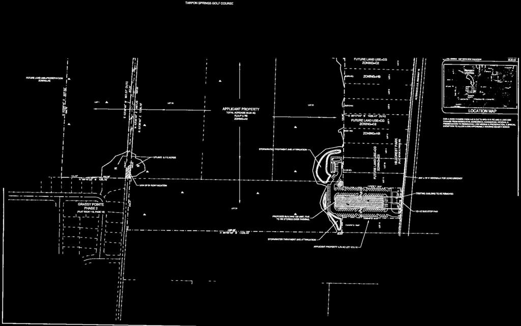
11 LOCATION MAP z/lu MAP-1 z/lu Zoning Land Use From: A-E, Agricultural Estate Residential & C-2, General Retail Commercial & Limited Services To: RPD-1 0, Residential Planned Development, 10 units per acre & P/C, Preservation Conservation From: Residential Suburban, Commercial General & Preservation To: Residential Low Medium & Preservation And a Special Exception to allow a 50% affordable housing density bonus. Parcel I.D. 24/27/15/39960/000/0120; 24/27/15/89280/000/2100, 2000, 2400 & 24/27/15/89262/000/0100 Prepared by: Pinellas County Strategic Planning & Initiatives May 2013 N
12 ROS St Andrens Dr E Curlew Pl A-E A-E A-E C-2 Polo Club Dr A-E A-E Eleanor St C-2 A-E A-E C-2 A-E Denise St Briland St Liam Ave Longview Ln Future Land Use Pinellas County, Florida Residential Residential Suburban Residential Low Mixed Use Residential / Office General Commercial Oriole Commercial Cir General Blue Jay Cir Public / Semi-Public Preservation Grassy Point Blvd Recreation / Open-Space Flamingo Cir Institutional Denise St Hillcrest St Hummingbird Trail A-E Terrace Rd Highland Rd W Klosterman Rd Robin Tr Roberts Rd S Pinellas Ave C-2 Fred Marquis Pinellas Trail Suwannee Ave Carolina Ave Earl St Vermont Ave Virginia Ave Klosterman Oaks Blvd MAP-2 z/lu Zoning Land Use From: A-E, Agricultural Estate Residential & C-2, General Retail Commercial & Limited Services To: RPD-1 0, Residential Planned Development, 10 units per acre & P/C, Preservation Conservation From: Residential Suburban, Commercial General & Preservation To: Residential Low Medium & Preservation And a Special Exception to allow a 50% affordable housing density bonus. Parcel I.D. 24/27/15/39960/000/0120; 24/27/15/89280/000/2100, 2000, 2400 & 24/27/15/89262/000/0100 Prepared by: Pinellas County Strategic Planning & Initiatives May 2013 N


13 St Andrens Dr Subject Area Polo Club Dr E Curlew Pl Eleanor St Denise St Denise St Vermont Ave arq uis Hillcrest St Terrace Rd Virginia Ave ine SP Grassy Suwannee Ave Carolina Ave Highland Rd lvd tb Po in llas Ave Fre dm Liam Ave Pin ella st rai l Longview Ln Briland St Earl St Flamingo Cir z/lu Zoning From: To: Land Use From: To: A-E, Agricultural Estate Residential & C-2, General Retail Commercial & Limited Services RPD-1 0, Residential Planned Development, 10 units per acre & P/C, Preservation Conservation Residential Suburban, Commercial General & Preservation Residential Low Medium & Preservation Klosterman Oaks Blvd ts Rd Rober Blue Jay Cir Robin Tr Oriole Cir Hummingbird Trail W Klosterman Rd MAP-3 And a Special Exception to allow a 50% affordable housing density bonus. And a Special Exception to allow a 50% affordable housing density bonus and a transfer of density with a Development Agreement for a 24/27/15/89280/000/2100, 2000, 2400 & 24/27/15/89262/000/ unit residential24/27/15/39960/000/0120; development having a maximum height of 70 ft. Parcel I.D. Parcel ID #: 24/27/15/39960/000/0120; & 23/27/15/89262/000/0100 Pinellas County Strategic Planning & Initiatives- June 2013 Prepared by: Pinellas24/27/15/89280/000/2100,2200,2400 County Strategic Planning & Initiatives May 2013 N
14 ROS St Andrens Dr E Curlew Pl Polo Club Dr Eleanor St Denise St Briland St Liam Ave Longview Ln Grassy Point Blvd Denise St Hillcrest St Terrace Rd Highland Rd S Pinellas Ave Fred Marquis Pinellas Trail Suwannee Ave Earl St Vermont Ave Carolina Ave Virginia Ave W Klosterman Rd Oriole Cir Blue Jay Cir Tarpon Springs Flamingo Unincorporated Cir Area Hummingbird Trail Robin Tr Roberts Rd Klosterman Oaks Blvd MAP-4 z/lu Zoning Land Use From: A-E, Agricultural Estate Residential & C-2, General Retail Commercial & Limited Services To: RPD-1 0, Residential Planned Development, 10 units per acre & P/C, Preservation Conservation From: Residential Suburban, Commercial General & Preservation To: Residential Low Medium & Preservation And a Special Exception to allow a 50% affordable housing density bonus. Parcel I.D. 24/27/15/39960/000/0120; 24/27/15/89280/000/2100, 2000, 2400 & 24/27/15/89262/000/0100 Prepared by: Pinellas County Strategic Planning & Initiatives May 2013 N
15

16
17

18

19

20

21

22

23

24

25

26
27

28

29
30

31
32


33

34
35 PINELLAS COUNTY PLANNING DEPARTMENT TRAFFIC ANALYSIS FOR A PROPOSED LAND USE CHANGE LU#: Z/LU Jurisdiction: Pinellas County Revised: Received: 07/23/2013 Signoff: SITE DATA Parcel Size: Proposed for Amendment: 6.74 acres of uplands from CG, P, and RS to RLM and P Current Land Use Designation: Commercial General, Residential Suburban & Preservation Potential Use sf/acre(s) (upa) Sq.ft/Units sq/1,000 x(tgr) cap. Proj. trips (1) Single Family (2) Commercial 76,666-26, ,245 Total 1,360 Proposed Land Use Designation: Residential Low Medium & Preservation Potential Use sf/acre(s) (upa) Sq.ft/Units sq/1,000 x(tgr) cap. Proj. trips (1) Apartments * (1) Single Family Total 635 Potential Additional Daily Trips: -725 *See staff report for a detailed summary of proposed units requested by applicant. Road(s) ROADWAY IMPACT DATA - Trip Distribution % Distribution Traffic Vol. (AADT) (1) Alternate US Highway existing 16,000 28,500 Klosterman Rd to Meres Blvd proposed 15,275 27, PH 2012 AADT 2035 AADT Road(s) LOS V/CR extg. w/ chg. extg. w/ chg. (1) Alternate US Highway 19 D D D F F Klosterman Rd to Meres Blvd Road(s) Extg Planned Const. Future CMS Ln Cfg Improv. Year Ln Cfg Desig. Alternate US (1) Highway 19 Klosterman Rd to Meres Blvd 2U E D CON ABBREVIATIONS/NOTES AADT = Average Annual Daily Trips Ln. = Lanes AC = Acres LOS = Level of Service CAP = Capture Rate (i.e., % new trips) LTCM = Long Term Concurrency Management Corridor CCC = Congestion Containment Corridor MPO = Metropolitan Planning Organization CFG = Configuration N/A = t applicable CMS = Concurrency Management System PC = Partially controlled access CON = Constrained County Corridor PH = Peak Hour Const. = Construction SF = Square Feet D/U = Divided/undivided TGR = Trip Generation Rate E = Enhanced UPA = Units Per Acre FAR = Floor Area Ratio UTS = Units (dwelling) FDOT = Florida Department of Transportation V/CR = Volume-to-Capacity Ratio DEF= Deficient State Road MIS= Mitigating Improvement Scheduled 2035 traffic volumes from MPO, adjusted FDOT Regional Transportation Analysis model output Average daily level of service based on Generalized Daily LOS Volume Tables from FDOT 2010 LOS Manual ZLU Traffic Anaylsis_Mills.xlsx 3a
36 PINELLAS COUNTY PLANNING DEPARTMENT TRAFFIC ANALYSIS FOR A PROPOSED LAND USE CHANGE LU#: Z/LU Jurisdiction: Pinellas County Revised: Received: 07/23/2013 Signoff: SITE DATA Parcel Size: Proposed for Amendment: 6.74 acres of uplands from CG, P, and RS to RLM and P Current Land Use Designation: Commercial General, Residential Suburban & Preservation Potential Use sf/acre(s) (upa) Units sq/1,000 x(tgr) cap. Proj. trips (1) Single Family (2) Nursery 1, Total 142 Proposed Land Use Designation: Residential Low Medium & Preservation Potential Use sf/acre(s) (upa) Sq.ft/Units sq/1,000 x(tgr) cap. Proj. trips (1) Apartments * (1) Single Family Total 635 Potential Additional Daily Trips: 493 *See staff report for a detailed summary of proposed units requested by applicant. Road(s) ROADWAY IMPACT DATA - Trip Distribution % Distribution Traffic Vol. (AADT) (1) Alternate US Highway existing 16,000 28,500 Klosterman Rd to Meres Blvd proposed 16,493 28, PH 2012 AADT 2035 AADT Road(s) LOS V/CR extg. w/ chg. extg. w/ chg. (1) Alternate US Highway 19 D D D F F Klosterman Rd to Meres Blvd Road(s) Extg Planned Const. Future CMS Ln Cfg Improv. Year Ln Cfg Desig. Alternate US (1) Highway 19 Klosterman Rd to Meres Blvd 2U E D CON ABBREVIATIONS/NOTES AADT = Average Annual Daily Trips Ln. = Lanes AC = Acres LOS = Level of Service CAP = Capture Rate (i.e., % new trips) LTCM = Long Term Concurrency Management Corridor CCC = Congestion Containment Corridor MPO = Metropolitan Planning Organization CFG = Configuration N/A = t applicable CMS = Concurrency Management System PC = Partially controlled access CON = Constrained County Corridor PH = Peak Hour Const. = Construction SF = Square Feet D/U = Divided/undivided TGR = Trip Generation Rate E = Enhanced UPA = Units Per Acre FAR = Floor Area Ratio UTS = Units (dwelling) FDOT = Florida Department of Transportation V/CR = Volume-to-Capacity Ratio DEF= Deficient State Road MIS= Mitigating Improvement Scheduled 2035 traffic volumes from MPO, adjusted FDOT Regional Transportation Analysis model output Average daily level of service based on Generalized Daily LOS Volume Tables from FDOT 2010 LOS Manual ZLU _Millis Nursery Compare.xlsx 3a
37 Impact Assessment and Background Data for Staff Report Amendment to the Pinellas County Future Land Use Map and Pinellas County Zoning Atlas Map Case : Z/LU Site Location: Located approximately 670 ft. north of Terrace Road, in the unincorporated area of Tarpon Springs. Street Address: 1800 Alternate US Highway 19 (South Pinellas Avenue). Parcel Number: 24/27/15/39960/000/0120, 24/27/15/89280/000/2100, 2200, 2400 & 24/27/89262/000/0100 Prepared by: RAB Date: 07/24/2013 Proposed Amendment From: Future Land Use Designation(s): RS, CG, and P acres 6.74 Zoning Designation(s): A-E and C-2 acres 6.74 Proposed Amendment To: Future Land Use Designation(s): RLM and P acres 6.74 Zoning Designation(s): RPD-10 acres 6.74 Development Agreement? New Amended Affordable Housing Density Bonus? How many proposed units total: 126 Local Planning Agency - Impact Assessment Z/LU
38 INFRASTRUCTURE IMPACTS SOLID WASTE IMPACT ASSESSMENT LAND USE DESIGNATIONS SOLID WASTE Total Tons/Year * EXISTING Commercial General, Residential Suburban & Preservation Commercial General (27,139 sq. ft) 1.76 acres x 43,560 sq. ft./ acre= 76,666 sq. ft. 76,666 sq. ft. x.35 FAR = 26,833 sq. ft 26,833 sq. ft x 10.2 lbs per sq. ft. (retail store) = 26,833 lbs 273,697 lbs/2,000lbs = 137 Tons 12 single family units 12 units x 1.66 tons per unit (residential factor) = 20 Tons 20 Tons PROPOSED Residential Low Medium & Preservation 126 proposed dwelling units 126 dwelling units x 1.66 tons per unit (residential factor) = 209 Tons 209 Tons NET DIFFERENCE +52 Tons/year * (n Residential) Gross Floor Area x Solid Waste Disposal Rate / 2,000 lbs = Total Tons per Year * (Residential) Units x Annual Per Capita Rate = Total Tons per Year te: Based upon Solid Waste Disposal Rate determined by DUS Consultants for the Solid Waste Authority of Palm Beach County. POTABLE WATER AND SANITARY SEWER IMPACT ASSESSMENT LAND USE DESIGNATIONS EXISTING Commercial General, Residential Suburban & Preservation PROPOSED Residential Low Medium & Preservation POTABLE WATER GPD * Commercial General (26,833 sq. ft) 26,833 sq. ft. x 0.05 per sq. ft = 1,342 GPD 12 single family units x 266/unit = 3,192 GPD 1,357 GPD + 3,192 GPD = 4,549 GPD 126 proposed dwelling units 126 dwelling units x 200/unit = 25,200 GPD WASTEWATER GPD* Commercial General (26,833 sq. ft) 26,833 sq. ft. x 0.05 per sq. ft = 1,342 GPD 12 single family units x 266/unit = 3,192 GPD 1,357 GPD + 3,192 GPD = 4,549 GPD 126 proposed dwelling units 126 dwelling units x 200/unit = 25,200 GPD NET DIFFERENCE + 20,666 GPD + 20,666 GPD * (n Residential) Gross Floor Area x Consumption Rate = GPD * (Residential) Number of Units x Consumption Rate = GPD NOTE: GPD = Gallons per Day Local Planning Agency - Impact Assessment Z/LU
39 TRANSPORTATION AND ROADWAY IMPACTS Does the proposed amendment impact a concurrency corridor (i.e., constrained, congestion containment, and/or long term concurrency management corridor)? Is the amendment located along a scenic/non-commercial corridor? YES or NO COMMENTS See staff report for details. ENVIRONMENTAL AND SITE CONDITIONS Identify any onsite soils. Are any classified as very limited or subject to subsidence? Are there any threatened, endangered or listed habitats or species onsite (including species of special concern)? Identify onsite vegetation; does the site contain any significant native vegetative communities (e.g., sandhill). Is the site located within the wellhead protection zone and/or aquifer recharge area? Identify the watershed in which the site is located. Is a portion of the site located within the 25 or 100 year floodplain? Does the site contain, or is it adjacent to any wetlands, rivers, creeks, lakes, marshes, Tampa Bay or the Gulf of Mexico, etc. YES or NO COMMENTS The site contains Samsula, Anclote, Astatula, Matlacha, St. Augustine, and Urban Land. Samsula and Anclote soils are classified as very limited and are subject to subsidence. Astatula and Matlacha soils are classified as not limited. St. Augustine soils are classified as somewhat limited and Urban Land is not rated. Unknown Wetland vegetation such as Cypress heads, and sandhills on the uplands. The site is located within the Klosterman Bayou watershed. Also, a portion of the site is identified on the Pinellas County Master Drainage Plan as a natural flood storage area. The majority of site is located within the 100 year floodplain, designated AE on the 2009 FEMA flood map. The majority of the acreage is wetland, and functions as a flood storage area. *The standard categories of soil classifications (i.e., severe, very severe etc.) have been replaced by Building Site Development Limitations (i.e., somewhat limited, very limited etc.) PUBLIC SAFETY Local Planning Agency - Impact Assessment Z/LU
40 Is the site located with the coastal storm area? Is the site located within a hurricane evacuation zone. If so, identify the zone. Identify the Fire District serving the proposed development. YES or NO COMMENTS The site is located within the hurricane evacuation zone B. The site is located within the Tarpon Springs Fire District. COMMUNITY IMPACTS Will approval of this amendment affect the provision of affordable housing; if so, explain the positive/negative impacts. Has the applicant sought/been issued an affordable housing finding by the Department of Community Development? Will the approval of the amendment result in the displacement of mobile home residents? Will the approval of the amendment result in the elimination of a water-dependent land use such as a marina or boat ramp? If so, identify how many ramps/lanes or slips will be eliminated. Would the amendment affect beach/waterfront accessibility? Is the amendment located within a County redevelopment/revitalization area; if so, is the amendment consistent with the community revitalization plan, vision, etc. Could the amendment have a significant impact on an adjacent local government? Is the amendment located within a designated brownfield area? Will the proposed amendment affect public school facilities? YES or NO COMMENTS See staff report for details. See additional restrictions however in the development agreement City of Tarpon Springs. Has the property been the subject of a previous amendment within the last 12 months? Is the property within 200 feet of a property under same owner that has been amended within the past 12 months? Is the land use amendment proposal equal to or greater than 10 acres in size? ***If yes, the case needs to go to DCA for additional review*** ATTACH THE FOLLOWING: Location Map Future Land Use Map with zoning designations Aerial Local Planning Agency - Impact Assessment Z/LU
41 AGENDA ITEM III. A. 2. Case. Z/LU Approximately 1.89 acres located at US Hwy 19, Clearwater. Zone Change From: R-6, Residential, Mobile Home Parks & Subdivisions (0.26 acre) To: CP-1, Commercial Parkway (0.26 acre) Land Use Change From: To: Residential/Office/Retail (0.27 acre), Residential Low (0.41 acre) & Preservation (1.21 acres) Residential/Office/General (1.59 acres) & Residential Low (0.30 acre) And a special exception to allow overflow parking in an R-6 zone.
42 LOCAL PLANNING AGENCY (LPA) RECOMMENDATION to the BOARD OF COUNTY COMMISSIONERS Regarding: Case. Z/LU LPA Recommendation: LPA Public Hearing: October 10, 2013 PLANNING STAFF RECOMMENDATION: Staff recommends that the LPA find that the proposed amendments to the Pinellas County Future Land Use Map and Zoning Atlas, and the requested Special Exception, are consistent with the Pinellas County Comprehensive Plan based on the findings in this Report. Staff further recommends that the LPA recommend approval of the proposed amendments and Special Exception (and concept plan), to the Pinellas County Board of County Commissioners. CASE SUMMARY APPLICANT S NAME: DISCLOSURE: Team Savage, Inc. Managing Members: Martin J. Skapik and el Hughes REPRESENTED BY: Michael J. Gaylor, P. E. LAND USE CHANGE ZONING CHANGE FROM: Residential/Office/Retail (0.27 acre) Residential Low (0.41 acre) & Preservation (1.21 acres) R-6, Residential, Mobile Home Parks and Subdivisions (0.26 acre) TO: Residential/Office/Retail (1.59 acres) and CP-1, Commercial Parkway (0.26 acre) Residential Low (0.30 acre) And a Special Exception to allow overflow parking in an R-6 zone. PROPERTY DESCRIPTION: Approximately 1.89 acres located at U.S Highway19, Clearwater. PARCEL ID(S): 18/28/16/00000/430/0100, 0500, 0300 & 18/28/16/20106/021/0010 PROPOSED BCC HEARING DATE: vember 19, 2013 CORRESPONDENCE RECEIVED TO DATE: One letter received in opposition 1
43 Z/LU Page 2 PERSONS APPEARING AT THE LOCAL PLANNING AGENCY HEARING: (Type in correspondence) SURROUNDING ZONING AND LAND USE FACTS: Subject Property: Adjacent Properties: rth East South West Land Use Category Preservation and Residential/Office/Retail & Residential Low Residential/Office/Retail, and Preservation Residential Low, Preservation and Residential Medium Residential/Office/Retail, Preservation, and Residential/Office General Residential/Office General and Industrial Limited Zoning Existing Use Designation R-6 and CP-1 Motorcycle/Watercraft Retail Store, mobile home and vacant bldg. CP-1 Retail Shopping Plaza R-6 and R-4 Mobile home and Duplex CP-1 and within City of Clearwater M-1 and the City of Dunedin Retail Shopping Plaza, and Office complex Bank and Storage Warehouses STAFF DISCUSSION AND ANALYSIS BACKGROUND This subject site, comprising four parcels, is currently occupied by a motorcycle/watercraft retail store on the two parcels fronting U.S. Highway 19, while the easternmost parcel contains a vacant building, and the southernmost parcel contains a mobile home. A large portion of the subject area is designated as Preservation on the Future Land Use Map (FLUM), appearing to reflect the County s original Master Drainage Plan for the area. In fact, the site has been developed for many years and any wetlands were likely filled before specific protections were in place. The zoning on these two developed parcels is CP- 1, Commercial Parkway, and the portion not designated on the FLUM as Preservation is designated with the Residential/Office/Retail (R/O/R) land use designation. The southernmost parcel is designated as Residential Low (RL) on the FLUM, with R-6 zoning as is the parcel to the east (which is also designated Preservation). The applicant wishes to expand their business and plans to use the parcel to the east for overflow parking and retention (the property was developed prior to stormwater treatment requirements), and the parcel to the south for grassed parking. Inclusion of the two additional parcels as a part of the overall subject site will enable the developer to improve the site by incorporating landscaping, stormwater treatment, and increased parking spaces. In order to accomplish this, the following is being requested: On the two developed parcels along U.S. Highway 19, the applicant is requesting a FLUM amendment to remove the Preservation category and replace it with the R/O/R category.
44 Z/LU Page 3 On the southernmost parcel, the applicant is requesting a FLUM amendment from RL to R/O/R and a zoning amendment from R-6 to CP-1. The applicant has indicated that the mobile home currently onsite will be removed and the parcel will be used for parking for the developed parcel to the north. On the eastern parcel, the applicant is requesting a Special Exception to allow for overflow parking (approximately 14 parking spaces located on the southern portion of the parcel), and a FLUM amendment on the northern portion of the parcel from Preservation to RL. This will be the location of the new retention pond for the business, and overflow parking. The Concept Plan (attached) depicts the proposed parking and stormwater retention pond, and includes a requirement that the onsite activities be screened from the neighboring residential area to the east by a 6 foot fence. COMPATIBILITY WITH SURROUNDING LAND USES The proposed R/O/R FLUM designation is consistent with the land use pattern in the immediate area. Furthermore, the Future Land Use Category Descriptions and Rules of the Comprehensive Plan indicate the R/OR designation is generally suited for locations along arterial roadways/thoroughfares where the area is suited for a mix of uses, with pedestrian and transit access, and the uses can serve as a transition between areas of greater and lesser intensity. In this case, U.S. Highway 19 is a major arterial, and the R/O/R designation serves as a transition/buffer between this major roadway corridor and residential uses to the east. The proposed CP-1, Commercial Parkway zoning district on the southernmost parcel is also considered an appropriate zoning district for the area, given the depth of CP-1 on other similarly designated parcels along this portion of the U.S. Highway 19 corridor. Regarding the proposed removal of the Preservation FLUM category, it appears that the category was placed on the parcels in the early 1980 s in association with the County s Master Drainage Plan. County staff has inspected the site and have determined that the Preservation category is no longer warranted, since the majority of site is entirely developed. However, it should be noted that a drainage easement and drainage pipe have been identified on the property, and at the time of site plan review County staff may require the width of the easement to be expanded in order to ensure access for emergencies or repairs. REQUEST FOR A SPECIAL EXCEPTION Lastly, a Special Exception is being requested to provide for overflow parking on the eastern parcel for the motorcycle/watercraft retail store. It has been reviewed against the General Standards contained in the County s Land Development Code (Section ); staff s assessment follows each of the review criteria below: (1) Criteria: All structures shall be adequately separated from adjacent and nearby uses by screening devices and/or open area. Staff notes that according to the attached Concept Plan, the proposed overflow parking area will be screened from the neighboring residential area to the north, west and east by a 6 solid fence. (2) Criteria: Excessive vehicular traffic is not generated on residential streets. Staff does not anticipate that the proposed overflow parking area will generate additional vehicular traffic on the nearby residential streets (in fact, there will not be any street access from the eastern parcel; all access to the overflow parking area will be internal from the subject site). This additional parking area should also help to alleviate any existing parking issues.
45 Z/LU Page 4 (3) Criteria: A vehicular parking or traffic problem is not created. Same as above. (4) Criteria: Appropriate drives, walks, and buffers are installed. Access to the parking area will be internal to the property, and there will be a solid fence and landscaping, this criteria should be met (see concept plan for details). The retention pond will also serve as a buffer between onsite activities and the residential area to the east. (5) Criteria: The proposed use will be in keeping with the purpose and intent of this Code and not adversely affect properties in the vicinity of the excepted use. Same as above. (6) Criteria: The setback requirements of the district in which the use is to be located shall be complied with. The proposed overflow parking area will meet all setback requirements. (7) Criteria: The parcel shall provide sufficient off-street parking. The proposed parking area to the south is intended to add additional parking spaces for the retail portion of the property. The parcel to the east, which is the subject of the request for the Special Exception, will allow for overflow parking. TRANSPORTATION IMPACTS AND CONCURRENCY It is anticipated that the proposed amendment from RL to the R/O/R FLUM category could generate approximately 92 additional average daily trips on the section of US Highway 19, from Main Street to Curlew Road. This section of U.S. Highway 19 is designated by the 2012 Concurrency Test Statement as a Long Term Concurrency Management Corridor, and is operating at a LOS F; therefore, the proposed development will be subject to concurrency management requirements during the site plan process. OTHER INFRASTRUCTURE IMPACTS The property is located within the Pinellas County Water Demand Planning Area and the rth County (William E Dunn) Wastewater Treatment Facility Service Area. The proposed amendment from RL to R/O/R would be expected to increase both potable water and wastewater impacts, respectively, by approximately 566 gallons per day, and solid waste disposal impacts could decrease by approximately 9.89 tons per year. SUMMARY In summary, when evaluating the overall compatibility of the request with the surrounding area and with the Comprehensive Plan, staff concludes that the proposed amendments will result in the FLUM properly reflecting the long-standing use of the property along U.S. Highway 19 for commercial activity by removal of the Preservation FLUM designation. Additionally, the R/O/R land use designation and CP-1 zoning district are compatible with surrounding FLUM categories and uses. With regard to the request for a Special Exception, the parking area on the easternmost parcel will be buffered from, and not have access to, adjacent residential uses. For these reasons, staff recommends approval of the zoning and land use amendments, as well as the Special Exception.
46 Z/LU Page 5 IMPLEMENTATION OF THE PINELLAS COUNTY COMPREHENSIVE PLAN Staff finds that the proposed amendment is consistent with the following adopted goal, objective, and policies of the Pinellas County Comprehensive Plan: FUTURE LAND USE ELEMENT: Goal 1: The pattern of land use in Pinellas County shall be orderly and reasonable in distribution and intensity, conserve natural resources, be in the overall public interest, and effectively serve the community and environmental needs of the population Policy: Plan designations on the Future Land Use Map shall be compatible with the natural environment, support facilities and services, and the land uses in the surrounding area Objective: Pinellas County shall promote the location of community or neighborhood commercial development within centers in order to achieve optimal land use relationships, avoid commercial intrusion and impacts into established neighborhoods, achieve compatibility with traffic movement objectives, minimize air pollution, and serve the immediate retail shopping needs of limited or defined geographic areas Policy: Pinellas County shall restrict the proliferation of strip commercial development in areas where it has not yet become established as the predominant commercial land use pattern Policy: Pinellas County shall permit commercial development in a manner that will maintain the economic vitality of recognized and established commercial areas. COUNTY DEVELOPMENT REGULATIONS Approval of this request does not ensure that the site can meet County development regulations, including concurrency management regulations, which apply at the time of site plan review. Attachment (Maps)
47 LOCATION MAP Z/LU ZLU Zoning From: R-6, Residential, Mobile Home Parks & Subdivisions (.264 acre) To: CP-1, Commercial Parkway Land Use From: Residential Low (.264 acre) & Preservation To: Residential/Office/Retail Parcel I.D.s 18/28/16/00000/430/0100, 0500, 0300 & 18/28/16/20106/021/0010 Prepared by: Pinellas County Strategic Planning & Initiatives July 2013 And a variance to allow a F.A.R. (Floor Area Ratio) of.22 where a F.A.R of.20 is allowed for the area between 297th Avenue rth & Highland Acres Drive and a Special Exception to allow overflow parking in an R-6 zone. Special Exception N MAP-1
48 69th ST N 69th WAY N Secol ST 70th ST N 298th AVE N Congress AVE 297th AVE N Subject Properties Future Land Use Pinellas County, Florida Residential Residential Low Residential Urban Residential Low Medium Residential Medium Mixed Use Residential / Office General Residential / Office / Retail Commercial Commercial General Industrial Industrial Limited Public / Semi-Public Preservation Institutional Transportation / Utility U.S. 19 rthside DR MAP-2 ZLU Zoning From: R-6, Residential, Mobile Home Parks & Subdivisions (.264 acre) To: CP-1, Commercial Parkway Land Use From: Residential Low (.264 acre) & Preservation To: Residential/Office/Retail Parcel I.D.s 18/28/16/00000/430/0100, 0500, 0300 & 18/28/16/20106/021/0010 Prepared by: Pinellas County Strategic Planning & Initiatives July 2013 And a variance to allow a F.A.R. (Floor Area Ratio) of.22 where a F.A.R of.20 is allowed for the area between 297th Avenue rth & Highland Acres Drive and a Special Exception to allow overflow parking in an R-6 zone. Special Exception N
49 U.S th ST N 69th WAY N Secol ST 70th ST N 298th AVE N Congress AVE 297th AVE N Subject Properties rthside DR MAP-3 ZLU Zoning From: R-6, Residential, Mobile Home And a variance to allow a F.A.R. (Floor Area Parks & Subdivisions (.264 acre) Ratio) of.22 where a F.A.R of.20 is allowed To: CP-1, Commercial Parkway for the area between 297th Avenue rth & Land Use From: Residential Low (.264 acre) & Preservation Highland Acres Drive and a Special Exception to allow overflow parking in an R-6 zone. To: Residential/Office/Retail Special Exception Parcel I.D.s 18/28/16/00000/430/0100, 0500, 0300 & 18/28/16/20106/021/0010 Prepared by: Pinellas County Strategic Planning & Initiatives July 2013 Special Exception N
50 U.S th ST N 69th WAY N Secol ST 70th ST N 298th AVE N Congress AVE 297th AVE N Subject Properties rthside DR Clearwater Dunedin Unincorporated Area MAP-4 ZLU Zoning From: R-6, Residential, Mobile Home Parks & Subdivisions (.264 acre) To: CP-1, Commercial Parkway Land Use From: Residential Low (.264 acre) & Preservation To: Residential/Office/Retail Parcel I.D.s 18/28/16/00000/430/0100, 0500, 0300 & 18/28/16/20106/021/0010 Prepared by: Pinellas County Strategic Planning & Initiatives July 2013 And a variance to allow a F.A.R. (Floor Area Ratio) of.22 where a F.A.R of.20 is allowed for the area between 297th Avenue rth & Highland Acres Drive and a Special Exception to allow overflow parking in an R-6 zone. Special Exception N

, Residential Low (.")
51 ROR CP-1 And a Special Parcel Exception to allow ID #: a 50% affordable 24/27/15 housing density /39960/0 bonus and a 00/0120; transfer of density 24/27/15 with a /89280/0 Development 00/2100, Agreement for a 2200, unit ROR 00 & residential 23/27/15 development CP-1 /89262/0 having a 00/0100 maximum height of 70 ft. CP-1 And a Special Exception to allow overflow parking in an R-6 zone. Residential/Office/Retail (.27 acre), Residential Low (.41 acre) & Preservation (1.21 acres) Subject Area (.26 acre)
52 PINELLAS COUNTY PLANNING DEPARTMENT TRAFFIC ANALYSIS FOR A PROPOSED LAND USE CHANGE LU#: Z/LU Jurisdiction: Pinellas County Revised: Received: 08/12/2013 Signoff: SITE DATA Parcel Size: 1.89 Proposed for Amendment: 0.26 Current Land Use Designation: Residential Low Potential Use sf/acre(s) x(far)/(upa) Units x(tgr) cap. Proj. trips (1) Single-Family Total 10 Proposed Land Use Designation: Residential/Office/Retail Potential Use sf/acre(s) x(far)/(upa) Sq. ft sf/1,000 x(tgr) cap. Proj. trips (1) Commercial , Total 105 Potential Additional Daily Trips: 92 Road(s) ROADWAY IMPACT DATA - Trip Distribution % Distribution Traffic Vol. (AADT) (1) US Highway 19 4,381 4,381 existing 69, ,000 Main Street to Curlew Road proposed 69, , PH 2013 AADT 2035 AADT Road(s) LOS V/CR extg. w/ chg. extg. w/ chg. (1) US Highway 19 F 1.23 F F F F Main Street to Curlew Road Road(s) Extg Planned Const. Future CMS Ln Cfg Improv. Year Ln Cfg Desig. (1) US Highway 19 Main Street to Curlew Road 6D N/A N/A N/A N/A ABBREVIATIONS/NOTES AADT = Average Annual Daily Trips Ln. = Lanes AC = Acres LOS = Level of Service CAP = Capture Rate (i.e., % new trips) LTCM = Long Term Concurrency Management Corridor CCC = Congestion Containment Corridor MPO = Metropolitan Planning Organization CFG = Configuration N/A = t applicable CMS = Concurrency Management System PC = Partially controlled access CON = Constrained County Corridor PH = Peak Hour Const. = Construction SF = Square Feet D/U = Divided/undivided TGR = Trip Generation Rate E = Enhanced UPA = Units Per Acre FAR = Floor Area Ratio UTS = Units (dwelling) FDOT = Florida Department of Transportation V/CR = Volume-to-Capacity Ratio DEF= Deficient State Road MIS= Mitigating Improvement Scheduled 2035 traffic volumes from MPO, adjusted FDOT Regional Transportation Analysis model output Average daily level of service based on Generalized Daily LOS Volume Tables from FDOT 2010 LOS Manual ZLU _Traffic Analysis.xlsx 3a
53 Impact Assessment and Background Data for Staff Report Amendment to the Pinellas County Future Land Use Map and Pinellas County Zoning Atlas Map Z/LU: Site Location: Located at the southeast corner of US Highway 19 and 297 th Avenue rth Street Address: US Highway 19, Clearwater Parcel Number: 18/28/16/00000/430/0100, 0500, 0300 & 18/28/16/20106/021/0010 Prepared by: RAB Date: 9/17/13 Proposed Amendment From: Future Land Use Designation(s): RL acres.26 te: Impacts have been based on proposed amendment on Parcel 3, (18/28/16/00000/430/0100). Zoning Designation(s): R-6 acres.26 Proposed Amendment To: Future Land Use Designation(s): R/O/R acres.26 Zoning Designation(s): CP-1 acres.26 Development Agreement? New Amended Affordable Housing Density Bonus? How many units: Local Planning Agency - Impact Assessment Z/LU
54 INFRASTRUCTURE IMPACTS SOLID WASTE IMPACT ASSESSMENT LAND USE DESIGNATIONS SOLID WASTE Total Tons/Year * EXISTING Residential Low.26 acres x 5.0 dwelling units per acre= 1 single family unit 1 x 1.66 tons/unit/year (residential factor) = 1.66 tons/year PROPOSED Residential/Office/Retail.26 acres x 43,560 sq. ft./ acre = 11,327 sq. ft. 11,327 sq. ft. x.20 FAR = 2,265 sq. ft. 2,265 sq. ft. x 10.2 lbs./sq.ft. (retail) = 23,103 lbs. /sq.ft. 23,103 lbs. /sq.ft. 2,000 lbs./ton= tons/year NET DIFFERENCE tons/year * (n Residential) Gross Floor Area x Solid Waste Disposal Rate / 2,000 lbs = Total Tons per Year * (Residential) Units x Annual Per Capita Rate = Total Tons per Year te: Based upon Solid Waste Disposal Rate determined by DUS Consultants for the Solid Waste Authority of Palm Beach County. POTABLE WATER AND SANITARY SEWER IMPACT ASSESSMENT LAND USE DESIGNATIONS EXISTING Residential Low PROPOSED Residential/Office/Retail POTABLE WATER GPD *.26 acres x 5.0 dwelling units per acre= 1 single family unit 1 x 266 per unit (residential factor) = 266 GPD.26 acres x 43,560 sq. ft./ acre = 11,327 sq. ft. 11,327 sq. ft. x.20 FAR = 2,265 sq. ft. 2,265 sq. ft. x 0.25 per sq. ft (commercial rate) = GPD WASTEWATER GPD*.26 acres x 5.0 dwelling units per acre= 1 single family unit 1x 266 per unit (residential factor) = 266 GPD.26 acres x 43,560 sq. ft./ acre = 11,327 sq. ft. 11,327 sq. ft. x.20 FAR = 2,265 sq. ft. 2,265sq. ft. x 0.25 per sq. ft (commercial rate) = GPD NET DIFFERENCE +566 GPD +566 GPD * (n Residential) Gross Floor Area x Consumption Rate = GPD * (Residential) Number of Units x Consumption Rate = GPD NOTE: GPD = Gallons per Day TRANSPORTATION AND ROADWAY IMPACTS Is the proposed amendment located within one half mile of a concurrency corridor (i.e., constrained, congestion containment, and/or long term concurrency management corridor)? Is the amendment located along a scenic/non-commercial corridor? YES or NO COMMENTS See staff report for details. Local Planning Agency - Impact Assessment Z/LU
55 ENVIRONMENTAL AND SITE CONDITIONS Identify any onsite soils. Are any classified as very limited or subject to subsidence? Are there any threatened, endangered or listed habitats or species onsite (including species of special concern)? Identify onsite vegetation; does the site contain any significant native vegetative communities (e.g., sandhill). Is the site located within the wellhead protection zone and/or aquifer recharge area? Identify the watershed in which the site is located. Is the site located within the 25 year floodplain? Is the site located within the 100 year floodplain? YES or NO COMMENTS The site contains Immokalee Soils & Urban Land, which has been classified as very limited. Landscaping on the site is proposed to be enhanced, which is identified on the attached Concept Plan The subject area is located within the Curlew Creek watershed. Does the site contain, or is it adjacent to any wetlands, rivers, creeks, lakes, marshes, Tampa Bay or the Gulf of Mexico, etc. *The standard categories of soil classifications (i.e., severe, very severe etc.) have been replaced by Building Site Development Limitations (i.e., somewhat limited, very limited etc.) PUBLIC SAFETY Is the site located with the coastal storm area? Is the site located within a hurricane evacuation zone. If so, identify the zone. Identify the Fire District serving the proposed development. YES or NO COMMENTS The subject site is located within the City of Clearwater Fire District. Local Planning Agency - Impact Assessment Z/LU
56 COMMUNITY IMPACTS Will approval of this amendment affect the provision of affordable housing; if so, explain the positive/negative impacts. Has the applicant sought/been issued an affordable housing finding by the Department of Community Development? Will the approval of the amendment result in the displacement of mobile home residents? Will the approval of the amendment result in the elimination of a water-dependent land use such as a marina or boat ramp? If so, identify how many ramps/lanes or slips will be eliminated. Would the amendment affect beach/waterfront accessibility? Is the amendment located within a County redevelopment/revitalization area; if so, is the amendment consistent with the community revitalization plan, vision, etc. Would the amendment have a significant impact on an adjacent local government? Is the amendment located within a designated brownfield area? Will the proposed amendment affect public school facilities? YES or NO COMMENTS Has the property been the subject of a previous amendment proposal within the last 12 months? Is the property within 200 feet of a property under same owner that has been amended within the past 12 months? ATTACH THE FOLLOWING: Location Map Future Land Use Map with zoning designations Aerial Local Planning Agency - Impact Assessment Z/LU

57
LOCAL PLANNING AGENCY
 LOCAL PLANNING AGENCY Pinellas County Courthouse - Fifth Floor County Commissioners Assembly Room Clearwater, Florida June 13, 2018 9:00 A.M. (Wednesday) I. CALL TO ORDER AGENDA LOCAL PLANNING AGENCY Pinellas
Pinellas County. Staff Report
 Pinellas County 315 Court Street, 5th Floor Assembly Room Clearwater, Florida 33756 Staff Report File #: 15-188, Version: 1 Agenda Date: 11/24/2015 Subject: Case. Q Z/LU-19-9-15 (Alice K. Gast, Trustee
Pinellas County. Staff Report
 Pinellas County 315 Court Street, 5th Floor Assembly Room Clearwater, Florida 33756 Staff Report File #: 16-111A, Version: 1 Agenda Date: 2/23/2016 Subject: Case No. Q Z-2-1-16 (Fitzgerald Motors, Inc.)
PINELLAS COUNTY COMPREHENSIVE PLAN
 PINELLAS COUNTY COMPREHENSIVE PLAN Future Land Use Map (FLUM) Category Descriptions and Rules Amended March 17, 2009 (Ordinance 09-17) Amended March 16, 2010 (Ordinance 10-18) Amended October 26, 2010
Marion County Board of County Commissioners
 Marion County Board of County Commissioners Date: 6/4/217 P&Z: 9/25/217 BCC Transmittal: 1/17/217 BCC Adopt: TBD Amendment No: 217-L6 Type of Application Large-Scale Comp Plan Amendment Request: Change
City File ZM th Street North St. Petersburg, FL Central Avenue, Suite 1600 St. Petersburg, FL 33701
 Staff Report to the St. Petersburg Community Planning & Preservation Commission Prepared by the Planning & Development Services Department, Urban Planning and Historic Preservation Division For Public
INDIAN RIVER COUNTY, FLORIDA. The Honorable Members of the Planning and Zoning Commission DEPARTMENT HEAD CONCURRENCE
 Public Hearing Legislative INDIAN RIVER COUNTY, FLORIDA M E M O R A N D U M TO: The Honorable Members of the Planning and Zoning Commission DEPARTMENT HEAD CONCURRENCE Robert M. Keating, AICP; Community
Cover Letter with Narrative Statement
 Cover Letter with Narrative Statement March 31, 2017 rev July 27, 2017 RE: Rushton Pointe Residential Planned Unit Development Application for Public Hearing for RPUD Rezone PL2015 000 0306 Mr. Eric Johnson,
Planning Department Oconee County, Georgia
 Planning Department Oconee County, Georgia STAFF REPORT REZONE CASE #: 6985 DATE: October 31, 2016 STAFF REPORT BY: Andrew C. Stern, Planner APPLICANT NAME: Williams & Associates, Land Planners PC PROPERTY
Glades County Staff Report and Recommendation Unified Staff Report for Small Scale Plan Amendment and Rezoning
 Glades County Staff Report and Recommendation Unified Staff Report for Small Scale Plan Amendment and Rezoning CASE NUMBERS: COMP17-02 and RZ17-02 DATE of STAFF REPORT: May 1, 2017 CASE TYPE: Application
Application to Amend the Bay County Zoning Map (Please type or print clearly)
") Application to Amend the Bay County Zoning Map (Please type or print clearly) File No.: Date Received: A) Applicant Information Owners Authorized name: agent: Mailing Mailing address: address: E-mail:
Application to Amend the Bay County Zoning Map (Please type or print clearly) File No.: Date Received: A) Applicant Information Owners Authorized name: agent: Mailing Mailing address: address: E-mail:
FUTURE LAND USE. City of St. Augustine Comprehensive Plan EAR-Based Amendments
 FUTURE LAND USE City of St. Augustine Comprehensive Plan EAR-Based Amendments Future Land Use Element FLU Goal To create an environment within the City and adjacent areas in which its residents have the
BOARD OF COUNTY COMMISSIONERS DATE: October 8, 2013 AGENDA ITEM NO. 20v-C,
 BOARD OF COUNTY COMMISSIONERS DATE: October 8, 2013 AGENDA ITEM NO. 20v-C, Consent Agenda D Regular Agenda D Public Hearing ~ County Administrator's Signature".\~ Vf7 ~,_,v Subject: Proposed Regular Amendments
TREASURE COAST REGIONAL PLANNING COUNCIL M E M O R A N D U M
 TREASURE COAST REGIONAL PLANNING COUNCIL M E M O R A N D U M To: Council Members AGENDA ITEM 5F From: Date: Subject: Staff July 16, 2010 Council Meeting Local Government Comprehensive Plan Review Draft
CITY OF TARPON SPRINGS Staff Report May 16, 2017
 CITY OF TARPON SPRINGS Staff Report May 16, 2017 TO: FROM: HEARING DATES: SUBJECT: MAYOR & BOARD OF COMMISSIONERS PLANNING & ZONING DEPARTMENT MAY 15, 2017 (PLANNING & ZONING BOARD) JUNE 6, 2017 (BOC 1
AGENDA LOCAL PLANNING AGENCY Pinellas County Courthouse, Clearwater, FL County Commissioners Assembly Room Fifth Floor January 11, :00 A.M.
 AGENDA LOCAL PLANNING AGENCY Pinellas County Courthouse, Clearwater, FL County Commissioners Assembly Room Fifth Floor January 11, 2018-9:00 A.M. I. CALL TO ORDER II. III. APPROVAL OF MINUTES for the December
The City of Carlsbad Planning Division A REPORT TO THE PLANNING COMMISSION. Item No. P.C. AGENDA OF: March 16, 2011 Project Planner: Shannon Werneke
 The City of Carlsbad Planning Division A REPORT TO THE PLANNING COMMISSION Item No. 2 Application complete date: January 24, 2011 P.C. AGENDA OF: March 16, 2011 Project Planner: Shannon Werneke Project
i? Subiect: DATE: April 21,2009,., AGENDA ITEM NO. Consent Agenda [7 Regular Agenda Public Hearing Countv Administrator's Siqnature
 DATE: April 21,2009,., AGENDA ITEM NO. Consent Agenda [7 Regular Agenda Public Hearing A Countv Administrator's Siqnature i? Subiect: Zoning Case No. (Q) ZILU-2-3-09 (Pinellas County Planning Director)
Chapter 100 Planned Unit Development in Corvallis Urban Fringe
 100.100 Scope and Purpose. Chapter 100 Planned Unit Development in Corvallis Urban Fringe (1) All applications for land divisions in the Urban Residential (UR) and Flood Plain Agriculture (FPA) zones within
PALM BEACH COUNTY PLANNING, ZONING AND BUILDING DEPARTMENT ZONING DIVISION
 PALM BEACH COUNTY PLANNING, ZONING AND BUILDING DEPARTMENT ZONING DIVISION Application No.: Z-2014-01627 Application Name: Dazco Center Control No.: 2003-00040 Applicant: 4730 Hypoluxo LLC Owners: 4730
COMPREHENSIVE PLAN FUTURE LAND USE MAP AMENDMENT APPLICATION
 COUNTY STAFF DATA ONLY Date Received: Project No. CPA-20 - GADSDEN COUNTY DEPARTMENT OF PLANNING & COMMUNITY DEVELOPMENT 1-B East Jefferson Street, Post Office Box 1799, Quincy, FL 32353-1799 PLANNING
Plans shall be drawn at a readable scale, signed, and sealed by a Florida Registered Engineer. The application package shall include:
 CHAPTER 400. SECTION 403. PERMIT TYPES AND APPLICATIONS SITE DEVELOPMENT 403.3. Preliminary Site Plans (PSP) A. Intent and Purpose PSPs are used to identify existing site conditions and demonstrate general
APPLICATION FOR A COMPREHENSIVE PLAN AMENDMENT
 APPLICATION FOR A COMPREHENSIVE PLAN AMENDMENT Community Development Department 9220 Bonita Beach Rd, Suite 111 Bonita Springs, FL 34135 Phone: 239 444 6150 Fax: 239 444 6140 I. APPLICANT/AGENT/OWNER INFORMATION
Cobb County Community Development Agency Zoning Division 1150 Powder Springs St. Marietta, Georgia 30064
 Cobb County Community Development Agency Zoning Division 1150 Powder Springs St. Marietta, Georgia 30064 Case # Z-63 Public Hearing Dates: PC: 11-06-18 BOC: 11-20-18 SITE BACKGROUND Applicant: Loyd Development
PALM BEACH COUNTY PLANNING, ZONING AND BUILDING DEPARTMENT ZONING DIVISION
 PALM BEACH COUNTY PLANNING, ZONING AND BUILDING DEPARTMENT ZONING DIVISION Application No.: CA-2012-00688 Control No.: 2011-00552 Applicant: Garry Bernardo Owners: Garry Bernardo Agent: Frogner Consulting,
REPORT OF THE PLANNING AND DEVELOPMENT DEPARTMENT FOR APPLICATION FOR REZONING ORDINANCE TO PLANNED UNIT DEVELOPMENT SEPTEMBER 22, 2016
 BEL REPORT OF THE PLANNING AND DEVELOPMENT DEPARTMENT FOR APPLICATION FOR REZONING ORDINANCE 2016-576 TO PLANNED UNIT DEVELOPMENT SEPTEMBER 22, 2016 The Planning and Development Department hereby forwards
TREASURE COAST REGIONAL PLANNING COUNCIL M E M O R A N D U M. To: Council Members AGENDA ITEM 10A
 TREASURE COAST REGIONAL PLANNING COUNCIL M E M O R A N D U M To: Council Members AGENDA ITEM 10A From: Date: Subject: Staff April 20, 2007 Council Meeting Local Government Comprehensive Plan Review Draft
31, Township 29 South, Range 25 East, Polk County, Florida, as depicted by the Land Use Plan attached
 ORDINANCE NO. 2013-04 AN ORDINANCE AMENDING THE ZONING MAP OF THE CITY OF BARTOW, FLORIDA, REZONING APPROXIMATELY 2. 2 ACRES OF LAND OWNED BY BALA3I OF POLK COUNTY, LLC AND LOCATED IN SECTION 31, TOWNSHIP
STAFF REPORT. Community Development Director PO Box 4755 Beaverton, OR 97076
 STAFF REPORT HEARING DATE: July 7, 2010 TO: Planning Commission STAFF: Jana Fox, Assistant Planner PROPOSAL: Southeast Beaverton Office Commercial Zoning Map Amendment (ZMA2010-0006) LOCATION: The subject
9. REZONING NO Vicinity of the northwest corner of 143 rd Street and Metcalf Avenue
 9. REZONING NO. 2002-15 Vicinity of the northwest corner of 143 rd Street and Metcalf Avenue 1. APPLICANT: Andrew Schlagel is the applicant for this request. 2. REQUESTED ACTION: The applicant is requesting
APPLICANT NAME SUBDIVISION NAME DEVELOPMENT NAME LOCATION. CITY COUNCIL DISTRICT Council District 4 PRESENT ZONING PROPOSED ZONING
 SUBDIVISION, PLANNED UNIT DEVELOPMENT, PLANNING APPROVAL, ZONING AMENDMENT, & SIDEWALK WAIVER REQUEST STAFF REPORT Date: February 17, 2010 APPLICANT NAME SUBDIVISION NAME DEVELOPMENT NAME LOCATION David
Affordable Housing Plan
 Affordable Housing Plan CORDOVA HILLS SPECIAL PLANNING AREA 1 Proposed Project Conwy LLC is the master developer ( Master Developer ) of that certain real property in the County of Sacramento ( County
PUTNAM COUNTYCOMPREHENSIVE PLAN
 COMPREHENSIVE PLAN EXHIBIT AA COMPREHENSIVE PLAN A. Future Land Use Element Goals, Objectives, Policies This section proposed objectives and policies, which will assist Putnam County Commissioners and
PALM BEACH COUNTY PLANNING, ZONING AND BUILDING DEPARTMENT ZONING DIVISION
 PALM BEACH COUNTY PLANNING, ZONING AND BUILDING DEPARTMENT ZONING DIVISION Application No.: Z-2014-00661 Application Name: Kunnemann Rezoning Control No.: 2003-30365 Applicant: Kunnemann, Roy G. Tr Owner:
PALM BEACH COUNTY PLANNING, ZONING AND BUILDING DEPARTMENT ZONING DIVISION
 PALM BEACH COUNTY PLANNING, ZONING AND BUILDING DEPARTMENT ZONING DIVISION Application No.: Z-2016-00663 Application Name: Autism School Control No.: 2014-00133 Applicant: Dayna2, LLC Owners: Dayna2, LLC
MEMORANDUM. Douglas Hutchens, Interim City Manag~ August 4, 2016 / Greg Rice, Director of Planning & Development
 Agenda Item: Meeting Date: PH-1 8/18/16 TO: THROUGH: DATE: FROM: SUBJECT: PRESENTER: RECOMMENDATION: BUDGET IMP ACT: PAST ACTION: NEXT ACTION: ATTACHMENTS: BACKGROUND: City Commission MEMORANDUM Douglas
Chapter 7 SITE DEVELOPMENT STANDARDS
 Chapter 7 SITE DEVELOPMENT STANDARDS CHAPTER 7 SITE DEVELOPMENT STANDARDS Section 701 Purpose and Intent The purpose of this Chapter is to establish minimum site requirements for the development and use
AGENDA ITEM SUMMARY GLADES COUNTY BOARD OF COUNTY COMMISSIONERS
 AGENDA ITEM SUMMARY GLADES COUNTY BOARD OF COUNTY COMMISSIONERS SUBJECT: Case Number COMP17-01, Legend Moto LLC This is a Legislative Hearing. DEPARTMENT REQUEST: The Community Development Department requests
2030 General Plan. December 6, 7 pm
 2030 General Plan GPAC Meeting #9 GPAC Meeting #9 December 6, 7 pm City Council Input on Working Draft Land Use Map Council discussed GPAC & PC versions of the working draft land use map 11/28 Council
TREASURE COAST REGIONAL PLANNING COUNCIL M E M O R A N D U M. To: Council Members AGENDA ITEM 9D
 TREASURE COAST REGIONAL PLANNING COUNCIL M E M O R A N D U M To: Council Members AGENDA ITEM 9D From: Date: Subject: Staff May 15, 2015 Council Meeting Local Government Comprehensive Plan Review Draft
Not Present: Steve Klar Charlene Beyer (non-voting School Board Representative)
") Clearwater, Florida, The Pinellas County Local Planning Agency (LPA) (as established by Section 134-12 of the Pinellas County Land Development Code, as amended) met in regular session in the County Commission
Clearwater, Florida, The Pinellas County Local Planning Agency (LPA) (as established by Section 134-12 of the Pinellas County Land Development Code, as amended) met in regular session in the County Commission
Planned Residential Development ( PRD ) Application
 Application") FOR PLANNING USE ONLY Application # PRD Application Fee $ Receipt No. Filing Date Completeness Date Planned Residential Development ( PRD ) Application A. PROJECT INFORMATION 1. Project Name: 2. Address
FOR PLANNING USE ONLY Application # PRD Application Fee $ Receipt No. Filing Date Completeness Date Planned Residential Development ( PRD ) Application A. PROJECT INFORMATION 1. Project Name: 2. Address
TOWN OF ORO VALLEY PLANNING & ZONING COMMISSION MEETING DATE: December 6, 2011
 PLANNING & ZONING COMMISSION MEETING DATE: December 6, 2011 TO: FROM: SUBJECT: PLANNING & ZONING COMMISSION Matt Michels, Senior Planner mmichels@orovalleyaz.gov; tel. 229-4822 Public Hearing: Rancho de
SUBDIVISION, PLANNED UNIT DEVELOPMENT, PLANNING APPROVAL, ZONING AMENDMENT, & SIDEWALK WAIVER REQUEST STAFF REPORT Date: February 17, 2010
 SUBDIVISION, PLANNED UNIT DEVELOPMENT, PLANNING APPROVAL, ZONING AMENDMENT, & SIDEWALK WAIVER REQUEST STAFF REPORT Date: February 17, 2010 APPLICANT NAME SUBDIVISION NAME DEVELOPMENT NAME LOCATION David
PLANNED UNIT DEVELOPMENT STAFF REPORT Date: October 19, 2017
 PLANNED UNIT DEVELOPMENT STAFF REPORT Date: October 19, 2017 DEVELOPMENT NAME LOCATION Custom Boat Storage 3975 Demetropolis Road (East side of Demetropolis Road, 0.2± miles South of Halls Mill Road.)
CHAPTER Committee Substitute for Committee Substitute for Senate Bill No. 2188
 CHAPTER 2004-372 Committee Substitute for Committee Substitute for Senate Bill No. 2188 An act relating to land development; amending s. 197.502, F.S.; providing for the issuance of an escheatment tax
TREASURE COAST REGIONAL PLANNING COUNCIL M E M O R A N D U M
 TREASURE COAST REGIONAL PLANNING COUNCIL M E M O R A N D U M To: Council Members AGENDA ITEM 6A From: Date: Subject: Staff May 20, 2011 Council Meeting Local Government Comprehensive Plan Review Draft
Report to the Plan Commission February 4, 2013
 Report to the Plan Commission Legistar I.D. #28789 Conditional Use Requested Actions: Approval of a conditional use for a structure exceeding 10,0000 square feet of total floor area and an accessory building
AGENDA ITEM SUMMARY GLADES COUNTY BOARD OF COUNTY COMMISSIONERS
 AGENDA ITEM SUMMARY GLADES COUNTY BOARD OF COUNTY COMMISSIONERS SUBJECT: Case Number COMP17-02, RFYC, LLC This is a Legislative Hearing. DEPARTMENT REQUEST: The Community Development Department requests
Town of Cary, North Carolina Rezoning Staff Report 12-REZ-27 Morris Branch Town Council Public Hearing January 24, 2013
 Town of Cary, North Carolina Rezoning Staff Report 12-REZ-27 Morris Branch Town Council Public Hearing January 24, 2013 REQUEST To amend the Town of Cary Official Zoning Map to rezone approximately 9.0
ORANGE BLOSSOM GARDENS PLANNED UNIT DEVELOPMENT PREPARED BY: COASTAL ENGINEERING CONSULTANTS, INC.
 ORANGE BLOSSOM GARDENS A PLANNED UNIT DEVELOPMENT PREPARED BY: COASTAL ENGINEERING CONSULTANTS, INC. REVISED OCTOBER 19, 1992 BY THE COLLIER COUNTY LONG RANGE PLANNING DEPARTMENT REVISED DECEMBER, 2008
Dennis & Donna Blanchard, Agent. Dennis & Donna Blanchard/Disbrow Builders, Inc.
 Nassau County Growth Management Department 96161 Nassau Place Yulee, FL 32097 (904) 491-7328 (904) 491-3611 FAX Date of Hearing: March 3, 2015 BOARD MEMBERS Thomas Ford (Chairman) Gene Bennett John Stack
PALM BEACH COUNTY PLANNING, ZONING AND BUILDING DEPARTMENT ZONING DIVISION
 PALM BEACH COUNTY PLANNING, ZONING AND BUILDING DEPARTMENT ZONING DIVISION Application No.: Z/CA-2013-00493 Application Name: Trails Charter School Control No.: 2013-00085 Applicant: MG3 ALF Military LLC
FUTURE LAND USE ELEMENT
 FUTURE LAND USE ELEMENT GOAL: 2.1 A distribution of land uses throughout unincorporated Manatee County which limit urban sprawl, providing a predictable and functional urban form, encouraging development
Planning Department Oconee County, Georgia STAFF REPORT
 Planning Department Oconee County, Georgia STAFF REPORT REZONE CASE #: 7332 DATE: November 28, 2017 STAFF REPORT BY: Gabriel Quintas, Planner APPLICANT NAME: Smith Planning Group PROPERTY OWNER: John Hadden
Town of Cary, North Carolina Rezoning Staff Report 14-REZ-31 Cary Park PDD Amendment (Waterford II) Town Council Meeting January 15, 2015
 Town Council Meeting January 15, 2015") Town of Cary, North Carolina Rezoning Staff Report 14-REZ-31 Cary Park PDD Amendment (Waterford II) Town Council Meeting January 15, 2015 REQUEST To amend the Town of Cary Official Zoning Map by amending
Town of Cary, North Carolina Rezoning Staff Report 14-REZ-31 Cary Park PDD Amendment (Waterford II) Town Council Meeting January 15, 2015 REQUEST To amend the Town of Cary Official Zoning Map by amending
Town of Lisbon, Maine SUBDIVISION REVIEW APPLICATION
 Date Received: Fee Paid (amount): Applicant: Town of Lisbon, Maine SUBDIVISION REVIEW APPLICATION Subdivision Name/Title: This application must be received at the Town Office by close of business on the
MEMORANDUM! AGENDA ITEM #IV.C
 MEMORANDUM AGENDA ITEM #IV.C DATE: DECEMBER 07, 2018 TO: FROM: COUNCIL MEMBERS STAFF SUBJECT: LOCAL GOVERNMENT COMPREHENSIVE PLAN PROPOSED AND ADOPTED AMENDMENT CONSENT AGENDA Pursuant to the 1974 Interlocal
City of Largo, FL: Comprehensive Development Code Chapter 5: Land Use Classifications
 Section 5.1 Land Use Classification System 5.1.1 Relationship to State Growth Management Requirements Chapter 163 of the Florida Statutes provides enabling legislation for local governments to ensure that
Plat/Site Plan Application
 Instructions Plat/Site Plan Application For your application to be officially accepted for processing, you must complete this application in full. The owner/agent certification must be signed and notarized
HERON LANDING SUBDIVISION
 HERON LANDING SUBDIVISION Engineering Comments: Per FEMA guidelines, any development greater than 5 acres in size or subdivision 50 lots in size, requires a flood study. Width of drainage easement to be
Marion County Board of County Commissioners
 Marion County Board of County Commissioners Date: 12/29/2015 P&Z: 12/28/2015 BCC: 1/12/2016 Item Number 160113Z Type of Application Rezoning Request From: A-1 (General Agriculture) To: PUD (Planned Unit
Location Map S U M M A RY A N X G M P Z O N I TEM #2. Subject Site
 Staff Report to the Municipal Planning Board November 17, 2015 A N X 2 0 1 5-0 0 0 2 3 G M P 2 0 1 5-0 0 0 4 4 Z O N 2 0 1 5-0 0 0 3 9 I TEM #2 HOFFNER POINT Location Map Subject Site S U M M A RY Owner/Applicant
This is a New Findings of Adequacy for a Recorded Plat (Plat Book 179, Page 131) LAND USE Vacant Effective Plan: Pompano Beach
 LAND USE Vacant Effective Plan: Pompano Beach") Page 1 of 11 Board of County Commissioners, Broward County, Florida Environmental Protection and Growth Management Department Planning and Development Management Division DEVELOPMENT REVIEW REPORT PROJECT
Page 1 of 11 Board of County Commissioners, Broward County, Florida Environmental Protection and Growth Management Department Planning and Development Management Division DEVELOPMENT REVIEW REPORT PROJECT
Paul D. Ralph, BES, RPP, MCIP, Commissioner, Development Services Department
 Public Report To: From: Report Number: Development Services Committee Paul D. Ralph, BES, RPP, MCIP, Commissioner, Development Services Department DS-16-50 Date of Report: April 14, 2016 Date of Meeting:
Gadsden County Planning Commission Agenda Report
 Gadsden County Planning Commission Agenda Report Date of Meeting: June 16, 2016 To: From: Subject: Honorable Chairperson and Members of the Planning Commission Allara Mills Gutcher, AICP, Planning & Community
Comprehensive Plan Amendment #PLN , Reserve at Cannon Branch (Coles Magisterial District)
") COUNTY OF PRINCE WILLIAM 5 County Complex Court, Prince William, Virginia 22192-9201 PLANNING (703) 792-7615 FAX (703) 792-4758 OFFICE Internet www.pwcgov.org Christopher M. Price, AICP Director of Planning
COUNTY OF PRINCE WILLIAM 5 County Complex Court, Prince William, Virginia 22192-9201 PLANNING (703) 792-7615 FAX (703) 792-4758 OFFICE Internet www.pwcgov.org Christopher M. Price, AICP Director of Planning
Goals, Objectives and Policies
 Goals, Objectives and Policies 1. GOAL SUPPORT THE PROVISION OF DECENT, SAFE AND SOUND HOUSING IN A VARIETY OF TYPES, SIZES, LOCATIONS AND COSTS TO MEET THE NEEDS OF CURRENT AND FUTURE RESIDENTS OF UNINCORPORATED
Article Optional Method Requirements
 Article 59-6. Optional Method Requirements [DIV. 6.1. MPDU DEVELOPMENT IN RURAL RESIDENTIAL AND RESIDENTIAL ZONES Sec. 6.1.1. General Requirements... 6 2 Sec. 6.1.2. General Site and Building Type Mix...
TOWN OF WHITBY REPORT RECOMMENDATION REPORT
 TOWN OF WHITBY REPORT RECOMMENDATION REPORT REPORT TO: Planning and Development Committee REPORT NO: PL 4-08 DATE OF MEETING: January 21, 2008 FILE NO(S): MI-01-07 (SW- 2002-03) PREPARED BY: Planning Department
Board of County Commissioners Agenda Request
 Board of County Commissioners Agenda Request Date of Meeting: March 26, 2019 Date Submitted: March 19, 2019 To: From: Agenda Location: Subject: Honorable Chairman and Members of the Board Margaret Emblidge,
Conditional Use Permit case no. CU 14-06: Bristol Village Partners, LLC
 PLANNING AND ZONING COMMISSION STAFF REPORT August 7, 2014 Conditional Use Permit case no. CU 14-06: Bristol Village Partners, LLC CASE DESCRIPTION: LOCATION: LEGAL DESCRIPTION: EXISTING LAND USE: ZONING:
TOOELE COUNTY LAND USE ORDINANCE CHAPTER 31 Page 1
 CHAPTER 31 PLANNED COMMUNITY ZONE (P-C) Section 31-1 Definitions. 31-2 Purpose. 31-3 Land use districts. 31-4 P-C zone area minimum requirements. 31-5 Permitted uses. 31-6 Conditional uses. 31-7 Planning
Department of Planning Services Division of Planning SARAH E. KEIFER, AICP Phone: 302/ Director of Planning Services FAX: 302/
 Kent County Department of Planning Services Division of Planning SARAH E. KEIFER, AICP Phone: 302/744-2471 Director of Planning Services FAX: 302/736-2128 KRISTOPHER S. CONNELLY, AICP Assistant Director
Community Development
 Land Use Petition RZ-15-010 Concurrent Variance VC-15-010-01 Date of Staff Recommendation Preparation: August 14, 2015 Date of Planning Commission Recommendation: September 1, 2015 PROJECT LOCATION: DISTRICT/SECTION/LANDLOT(S):
ORDINANCE NO URBAN CORRIDOR AMENDMENTS
 ORDINANCE NO. 16-07 URBAN CORRIDOR AMENDMENTS AN ORDINANCE OF THE BOARD OF COUNTY COMMISSIONERS OF MANATEE COUNTY, FLORIDA, REGARDING COMPREHENSIVE PLANNING, AMENDING MANATEE COUNTY ORDINANCE NO. 89-01,
Implementation. Approved Master Plan and SMA for Henson Creek-South Potomac 103
 Implementation Approved Master Plan and SMA for Henson Creek-South Potomac 103 104 Approved Master Plan and SMA for Henson Creek-South Potomac Sectional Map Amendment The land use recommendations in the
City of Tarpon Springs, Florida STAFF REPORT
 City of Tarpon Springs, Florida STAFF REPORT July 17, 2018 TO: FROM: PLANNING AND ZONING BOARD MAYOR AND BOARD OF COMMISSIONERS PLANNING AND ZONING DEPARTMENT HEARING DATES: JULY 16, 2018 (PLANNING & ZONING
BOARD OF COUNTY COMMISSIONERS. Regular Agenda I RECOMMEND THAT THE BOARD OF COUNTY COMMISSIONERS (BOARD) APPROVE THE ZONING REQUEST.
 APPROVE THE ZONING REQUEST.") Consent Agenda D Regular Agenda Coun!l! Administrator's Signal~ BOARD OF COUNTY COMMISSIONERS D DATE: March 18, 2014 AGENDA ITEM NO. 6t!. Public Hearing [if" Subject: Zoning Case No. (Q) (Jessalyn Robinson,
Consent Agenda D Regular Agenda Coun!l! Administrator's Signal~ BOARD OF COUNTY COMMISSIONERS D DATE: March 18, 2014 AGENDA ITEM NO. 6t!. Public Hearing [if" Subject: Zoning Case No. (Q) (Jessalyn Robinson,
1 November 13, 2013 Public Hearing APPLICANT & PROPERTY OWNER: HOME ASSOCIATES OF VIRGINIA, INC.
 1 November 13, 2013 Public Hearing APPLICANT & PROPERTY OWNER: HOME ASSOCIATES OF VIRGINIA, INC. STAFF PLANNER: Carolyn A.K. Smith REQUEST: Conditional Change of Zoning (AG-1 & AG-2 Agricultural Districts
Not Present: Bill Bucolo Susan Reiter Paul Wikle Clint Herbic (non-voting School Board Representative)
") Clearwater, Florida, October 12, 2017 The Pinellas County Local Planning Agency (LPA) (as established by Section 134-12 of the Pinellas County Land Development Code, as amended) met in regular session
Clearwater, Florida, October 12, 2017 The Pinellas County Local Planning Agency (LPA) (as established by Section 134-12 of the Pinellas County Land Development Code, as amended) met in regular session
Expiration of Transportation Certificate of Concurrency for Application for Minor or Major Development; Approval
 Page 1 of 12 CHAPTER 3. CONCURRENCY 3.00.00. GENERALLY 3.00.01. Purpose and Intent The purpose of this chapter is to describe the requirements and procedures necessary to implement the concurrency provisions
Pinellas County. Staff Report
 Pinellas County 315 Court Street, 5th Floor Assembly Room Clearwater, Florida 33756 Staff Report File #: 15-996, Version: 1 Agenda Date: 1/26/2016 Subject: Case No. Q Z-33-12-15 (Pinellas County General
Town of Cary, North Carolina Rezoning Staff Report 14-REZ-20 Habitat for Humanity Evans Road Town Council Meeting October 16, 2014
 Town of Cary, North Carolina Rezoning Staff Report 14-REZ-20 Habitat for Humanity Evans Road Town Council Meeting October 16, 2014 REQUEST To amend the Town of Cary Official Zoning Map by rezoning 0.53
US 19 CORRIDOR Land Use & Economic Analysis-TARPON SPRINGS
 US 19 CORRIDOR Land Use & Economic Analysis-TARPON SPRINGS FINAL REPORT April 2018 Prepared by: HDR With assistance from: SB Friedman Development Advisors US 19 North Economic & Land Use Analysis This
Comprehensive Plan /24/01
 IV The is a central component of the Comprehensive Plan. It is an extension of the general goals and policies of the community, as well as a reflection of previous development decisions and the physical
PLANNED UNIT DEVELOPMENT (East), PLANNED UNIT DEVELOPMENT (West) STAFF REPORT Date: September 18, 2014
, PLANNED UNIT DEVELOPMENT (West) STAFF REPORT Date: September 18, 2014") PLANNED UNIT DEVELOPMENT (East), PLANNED UNIT DEVELOPMENT (West) STAFF REPORT Date: September 18, 2014 DEVELOPMENT NAME LOCATION McGowin Park, LLC PLANNED UNIT DEVELOPMENT (East) 1401 Satchel Paige Drive
PLANNED UNIT DEVELOPMENT (East), PLANNED UNIT DEVELOPMENT (West) STAFF REPORT Date: September 18, 2014 DEVELOPMENT NAME LOCATION McGowin Park, LLC PLANNED UNIT DEVELOPMENT (East) 1401 Satchel Paige Drive
THE REDEVELOPMENT PLAN
 PAGE 37 THE REDEVELOPMENT PLAN FUTURE LAND USE The Silver Terrace Redevelopment Area is currently designated as Redevelopment Area #4 on the City of Delray Beach Future Land Use Map (FLUM). This designation
BY BOARD OF COUNTY COMMISSIONERS AN ACT TO BE ENTITLED
 BY BOARD OF COUNTY COMMISSIONERS ORDINANCE NO. AN ACT TO BE ENTITLED AN ORDINANCE AMENDING THE PASCO COUNTY LAND DEVELOPMENT CODE, ARTICLE 700, BY REPEALING EXISTING SECTION 702, ENVIRONMENTALLY SENSITIVE
Medical Marijuana Special Exception Use Information
 Medical Marijuana Special Exception Use Information The Special Exception Use information below is a modified version of the Unified Development Code. It clarifies the current section 5:104 Special Exceptions
Kitsap County Department of Community Development
 Kitsap County Department of Community Development Staff Report and Recommendation Annual Comprehensive Plan Amendment Process for 2018 George s Corner LAMIRD Boundary Adjustment Report Date 7/16/2018 Hearing
40 +/- Acres Cornerstone Group- Colonial Boulevard 40 Acres Section 32, Township 44, Range 25. For Cornerstone Group. Prepared by
 DUE DILIGENCE REPORT 40 +/- Acres Cornerstone Group- Colonial Boulevard 40 Acres Section 32, Township 44, Range 25 For Cornerstone Group Prepared by David Douglas Associates, Inc. 2037 West First Street
Be linked by an internal circulation system (i.e., walkways, streets, etc.) to other structures within the IPUD;
 to other structures within the IPUD;") 2. HALIFAX ACTIVITY CENTER A. DESCRIPTIONS OF FUTURE LAND USE DESIGNATIONS Each of the future land use designations specified by Phase I of the Halifax Activity Center Plan, and the relationship of these
2. HALIFAX ACTIVITY CENTER A. DESCRIPTIONS OF FUTURE LAND USE DESIGNATIONS Each of the future land use designations specified by Phase I of the Halifax Activity Center Plan, and the relationship of these
HENDRY COUNTY PLANNING & ZONING DEPARTMENT POST OFFICE BOX S. MAIN STREET LABELLE, FLORIDA (863) FAX: (863)
 FAX: (863)") HENDRY COUNTY PLANNING & ZONING DEPARTMENT POST OFFICE BOX 2340 640 S. MAIN STREET LABELLE, FLORIDA 33975 (863) 675-5240 FAX: (863) 674-4194 STAFF REPORT CPA19-0001 Comprehensive Plan Map Amendment Local
HENDRY COUNTY PLANNING & ZONING DEPARTMENT POST OFFICE BOX 2340 640 S. MAIN STREET LABELLE, FLORIDA 33975 (863) 675-5240 FAX: (863) 674-4194 STAFF REPORT CPA19-0001 Comprehensive Plan Map Amendment Local
The Countywide Rules. Amended through May 31, 2016
 The Countywide Rules Amended through May 31, 2016 The Countywide Rules This document prepared and maintained by in its capacity as the Pinellas Planning Council 310 Court Street Clearwater, Florida 33756-5137
a. It is the intent of these regulations to encourage the preservation of natural resources and facilitate orderly growth in the County.
 Part V Transfer of Development Rights Section 246. 1. Intent a. It is the intent of these regulations to encourage the preservation of natural resources and facilitate orderly growth in the County. b.
UPPER MOUNT BETHEL TOWNSHIP NORTHAMPTON COUNTY, PENNSYLVANIA
 UPPER MOUNT BETHEL TOWNSHIP NORTHAMPTON COUNTY, PENNSYLVANIA JOINDER DEED / LOT CONSOLIDATION TOWNSHIP REVIEW PROCESS When accepting proposed Joinder Deeds / Lot Consolidations, review the Joinder Deed
Glades County Staff Report and Recommendation REZONING
 Glades County Staff Report and Recommendation REZONING CASE NUMBER: RZ15-01 DATE: October 2, 2015 CASE TYPE: Application for Rezoning REQUEST: J.J. Wiggins Memorial Trust is requesting a rezoning of 22.1±
REPORT OF THE PLANNING AND DEVELOPMENT DEPARTMENT FOR APPLICATION FOR REZONING ORDINANCE TO PLANNED UNIT DEVELOPMENT MAY 18, 2017
 BEL REPORT OF THE PLANNING AND DEVELOPMENT DEPARTMENT FOR APPLICATION FOR REZONING ORDINANCE 2016-805 TO PLANNED UNIT DEVELOPMENT MAY 18, 2017 The Planning and Development Department hereby forwards to
TREASURE COAST REGIONAL PLANNING COUNCIL M E M O R A N D U M. February 19, 2010 Regional Planning Council Meeting
 TREASURE COAST REGIONAL PLANNING COUNCIL M E M O R A N D U M To: Council Members AGENDA ITEM 5G From: Date: Subject: Staff February 19, 2010 Regional Planning Council Meeting Local Government Comprehensive