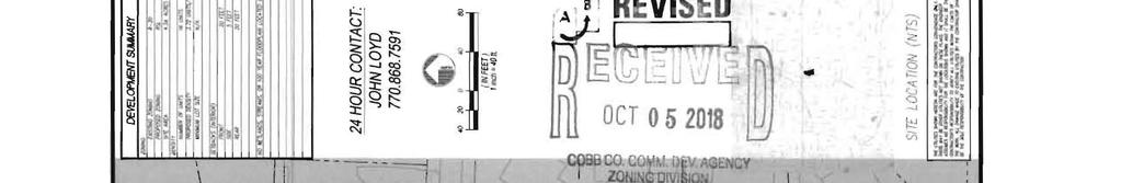
Cobb County Community Development Agency Zoning Division 1150 Powder Springs St. Marietta, Georgia 30064
|
|
|
- Berniece Parks
- 5 years ago
- Views:
Transcription
 868-7591 Email: john@loyddevelopment.")
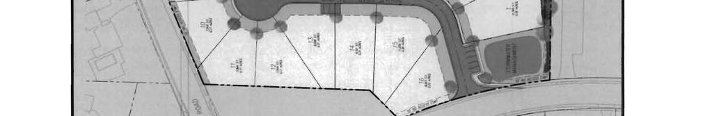
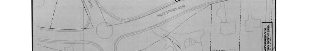
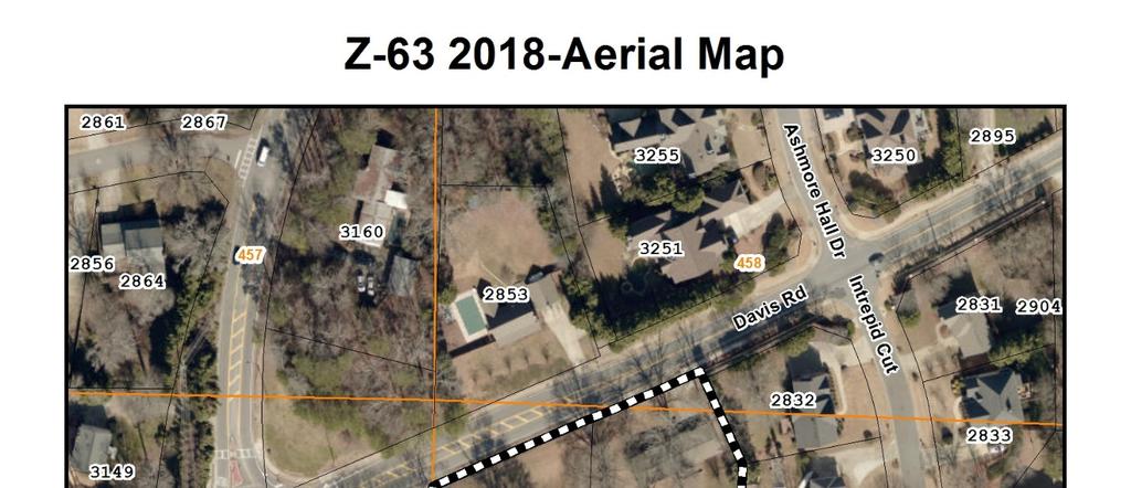
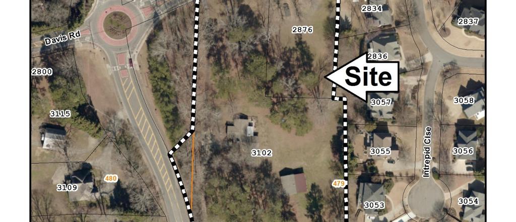
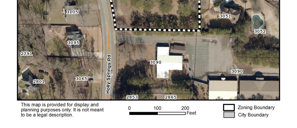
1 Cobb County Community Development Agency Zoning Division 1150 Powder Springs St. Marietta, Georgia Case # Z-63 Public Hearing Dates: PC: BOC: SITE BACKGROUND Applicant: Loyd Development Services Phone: (770) john@loyddevelopment.com Representative Contact: Garvis L. Sams, Jr. Phone: (770) gsams@slhb-law.com Titleholder: The Margaret A. Keheley Living Trust Property Location: East side of Holly Springs Road, and on the south side of Davis Road Address: 2876 Davis Road and 3102 Holly Springs Road Access to Property: Holly Springs Road QUICK FACTS Commission District: 3-Birrell Current Zoning: R-20 (Single-family Residential) Current use of property: Single-family houses Proposed zoning: RSL (Residential Senior Living) Proposed use: Non-supportive Senior Living Subdivision Future Land Use Designation: LDR (Low Density Residential) Site Acreage: 4.3 ac District: 16 Land Lot: 458, 479, and 480 Parcel #: and Taxes Paid: Yes FINAL ZONING STAFF RECOMMENDATION: (Zoning staff member: Terry Martin, MPA) Based on the analysis of this application, Staff recommends APPROVAL, subject to the following: 1. Maximum of 2.5 units per acre; 2. Board of Commissioners approve the final site plan; 3. No variances; 4. Fire Department comments and recommendations; 5. Water and Sewer Division comments and recommendations; 6. Stormwater Management Division comments and recommendations; and 7. Department of Transportation comments and recommendation.


2 Case # Z-63
3
 WEST Zoning: R-20 (Single-family Residential) EAST Zoning: R-15")
 SOUTH Zoning: R-20 (Single-family Residential) Future Land Use: LDR (Low Density")
4 North Zoning: R-20 (Single-family Residential) and R-15 (Singlefamily Residential) Future Land Use: LDR (Low Density Residential) WEST Zoning: R-20 (Single-family Residential) EAST Zoning: R-15 (Single-family Residential) Future Land Use: LDR (Low Density Residential) Future Land Use: LDR (Low Density Residential) SOUTH Zoning: R-20 (Single-family Residential) Future Land Use: LDR (Low Density Residential)
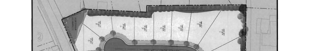
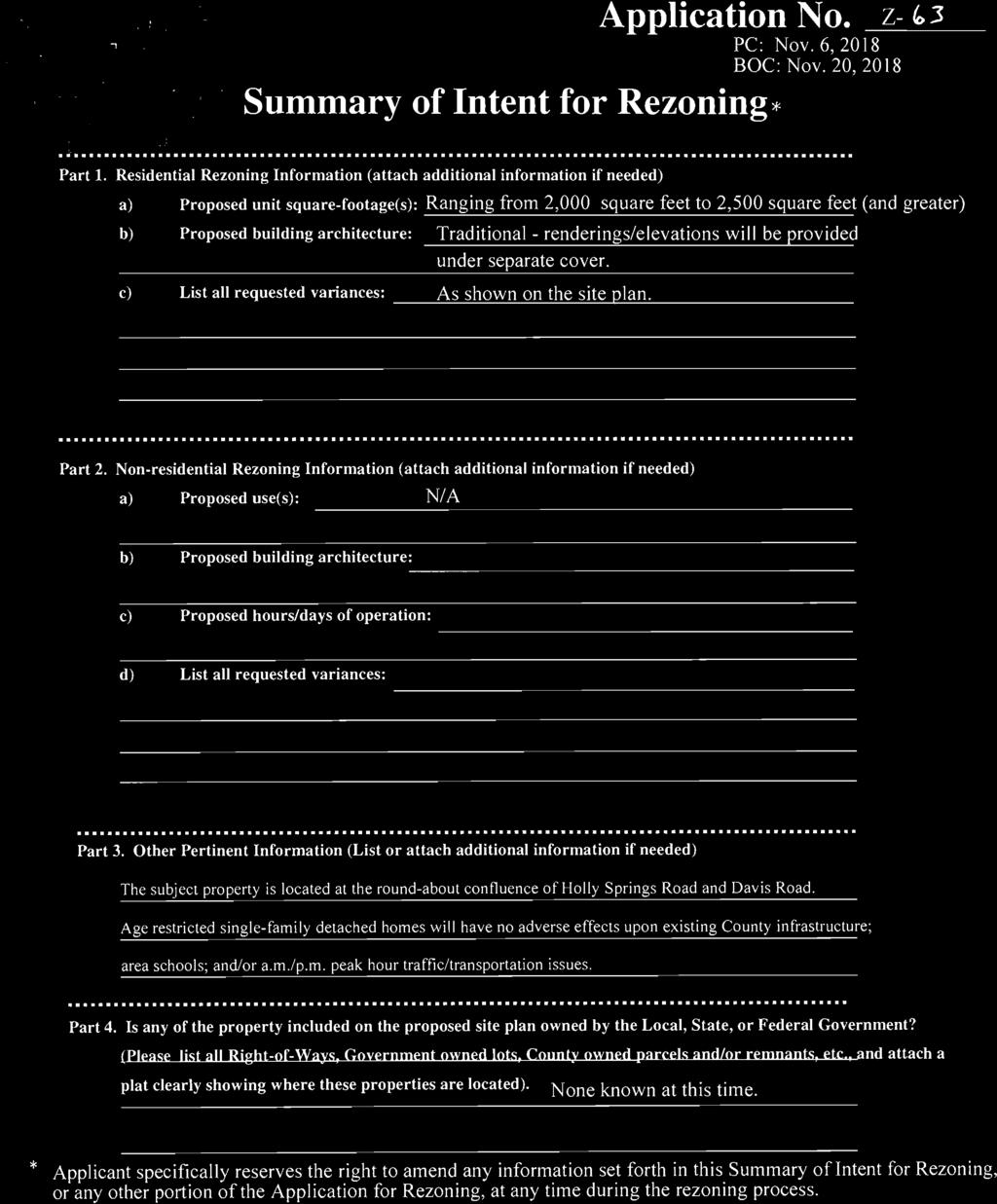
5 DEPARTMENT COMMENTS- Zoning Division Current zoning district for the property The R-20 district is established to provide locations for single-family residential uses or residentially compatible institutional and recreational uses which are within or on the edge of properties delineated for any residential category as defined and shown on the Cobb County Comprehensive Plan: A Policy Guide, adopted November 27, When residentially compatible institutional and recreational uses are developed within the R-20 district, they should be designed and built to ensure intensity and density compatibility with adjacent singlefamily detached dwellings and otherwise to implement the stated purpose and intent of this chapter. Requested zoning district for the property The RSL nonsupportive residential units is established to provide locations for the development of attached and detached dwelling units limited to those persons age 55 and older as defined by the Fair Housing Act as may be amended from time to time and shall not be established as a precedent for any other residential or nonresidential district. This residential use is designed to be located within any land use category other than industrial, industrial compatible, rural residential and very low density residential as defined by the Cobb County Comprehensive Plan, as may be amended from time to time, provided that it must be located along an arterial or collector roadway (as defined by the Cobb County Major Thoroughfare Plan, as may be amended from time to time). Summary of the applicant s proposal The applicant is requesting a rezoning to the Residential Senior Living (RSL) non-supportive zoning district to develop the property as a 16-lot subdivision. The house sizes will range from 2,000 square feet to 2,500 square feet and greater. The architecture of the homes will be traditional. Each house will have an attached two-car garage. Residential criteria Allowable units as zoned: 7 Proposed # of units: 16 Net density: 3.72 Increase of units: 9 Acres of floodplain/wetlands: 0 Impervious surface shown: No more than 55%
6 DEPARTMENT COMMENTS- Zoning Division (continued) Are there any zoning variances? Yes, the proposal will require the following setbacks as demonstrated: 1. Waive the landscape screening buffer adjacent to residentially zoned property from the required 20 foot to 10 feet along the southern property line and to zero along the western property line; 2. Waive the rear setback from the required 30 feet to 20 feet; and 3. Waive the requirement that the project include specific common or recreational space for residents. DEPARTMENT COMMENTS- Fire Department Modifications will be required to incorporate the Cobb County Fire Marshal s Office comments. Guest Parking Occupant parking shall be installed as required by zoning and additional guest parking shall be required as follows: Where driveways to two car garages exceed 50 feet in length, no additional guest parking is required. Where driveways to two car garages are at least 22 feet long and 20 feet wide, additional parking shall be required at.5 spaces per dwelling unit. Where driveways to two car garages are less than 22 feet long and 20 feet wide, additional parking shall be required at 1 space per dwelling unit. Where only single car garages are provided, additional parking shall be required at 2 spaces per dwelling unit. Guest parking spaces must be evenly distributed throughout the project. DEPARTMENT COMMENTS- Site Plan Review (County Arborist) No comment. DEPARTMENT COMMENTS- Cemetery Preservation No comment.
7 DEPARTMENT COMMENTS- School System The Cobb County Board of Education has concerns about this development. Senior residential developments generally have a negative impact on tax revenue for the Cobb County School District, unlike standard residential or commercial developments, where property taxes are not exempted. We, therefore, would like to express our concern to the Planning Commission and Board of Commissioners and ask that you take our concerns under consideration as you review this zoning application.
8 DEPARTMENT COMMENTS- Stormwater Management 1. Flood hazard: No 2. Flood hazard zone: Zone X 3. Drainage Basin: Sewell Mill Creek 4. Wetlands: No 5. Streambank buffer zone: No 6. Potential or known drainage problems exist for developments downstream from this site. 7. Stormwater discharges must be controlled not to exceed the existing capacity of the downstream storm drainage systems. 8. Stormwater discharges through an established residential neighborhood downstream. 9. Project engineer must evaluate the impact of increased volume of runoff generated by the proposed project on existing downstream drainage system(s). 10. Special site conditions and/or additional comments: All runoff from this site must be discharged into the existing stormwater infrastructure located to the northwest within the DOT right-of-way. The proposed development will result in an increase in impervious coverage over the current zoning category. To compensate, the First Flush Water Quality Best Management Practice Requirements must be elevated to the 1.5-inch rainfall event and each larger storm discharge controlled not to exceed the allowable discharge of the next lower, more frequent storm event (ie. 5-year storm event released at 2-year rate; 10-year event at 5-year rate; etc. to 100-year event at 50-year rate).
9 DEPARTMENT COMMENTS- Planning Division Cobb 2040 Comprehensive Plan: The parcel is within the Low Density Residential (LDR) future land use category. The purpose of the LDR category is to provide for areas that are suitable for low-density housing between one (1) and two and one-half (2.5) dwelling units per acre, and for non-supportive senior living housing that in certain circumstances may reach five (5) dwelling units per acre. Allowable residential density is dependent upon factors such as product type and mix, structure/building height, tract size, topographic conditions and the like, in order to provide compatibility with adjacent residential uses. Comprehensive Plan Designation: Consistent Inconsistent House Bill 489 Intergovernmental Agreement Zoning Amendment Notification Is the proposal within one-half mile of a city boundary? Yes No Was the city notified? Yes No N/A Specific Area Policy Guidelines: Yes No Masterplan/ Corridor Study Yes No Design guidelines area? Yes No Does the proposal plan comply with the design requirements? Yes No N/A Is the property within an Opportunity Zone? Yes No (The Opportunity Zone is an incentive that provides $3,500 tax credit per job in eligible areas if two or more jobs are being created. This incentive is for new or existing businesses) Is the property within an Enterprise Zone? Yes No (The Enterprise Zone is an incentive that provides tax abatements and other economic incentives for qualifying businesses locating or expanding within designated areas for new jobs and capital investment) Is the property eligible for the Façade Improvement Yes No Program? (The Façade Improvement Program is an incentive for owners and tenants to enhance the appearance of buildings. The CDBG program provides the funding. Properties must be either on the current inventory of redevelopment sites or in a corridor study area, and be in a census tract with at least 51% low and moderate income. The program serves to improve the economic viability of these areas.) (Planning comments continued on the next page)
10 DEPARTMENT COMMENTS- Planning Division (continued) Is the property eligible for incentives through the Yes No Commercial and Industrial Property Rehabilitation Program? (The Commercial and Industrial Property Rehabilitation Program Is an incentive that provides a reduction in ad valorem property taxes for qualifying redevelopment in eligible areas) Note: For more information on incentives, please call the Community Development Agency- Economic Development Division at or find information online at Special District Is this property within the Cumberland Special Yes No District #1 (hotel/motel fee)? Is this property within the Cumberland Special Yes No District #2 (ad valorem tax)? Is this property within the Six Flags Special Service District? Yes No Dobbins Air Reserve Base Zones Is the property within the Dobbins Airfield Safety Zone? Yes No Is the property within the Clear Zone (CZ)? Yes No Is the property within the Accident Potential Zone (APZ I)? Yes No Is the property within the Accident Potential Zone II (APZ II)? Yes No Is the property within the Noise Zone? Yes No Is the property within the Bird/Wildlife Air Strike Hazard Area (BASH)? Yes No Historic Preservation After consulting various county historic resources surveys, historic maps, archaeology surveys and Civil War trench location maps, staff finds that no known significant historic resources appear to be affected by this application.
11 DEPARTMENT COMMENTS- Water and Sewer Water comments: Available at development: YES NO Fire flow test required: YES NO Size and location of existing water main(s): 8 in Holly Springs Road Additional water comments: Note: These comments only reflect what facilities were in existence at the time of this review. Developer may be required to install/upgrade water mains based on fire flow test results or Fire Department code. This will be addressed in the Plan Review process. Sewer comments: In the drainage basin: YES NO At development: YES NO Approximate distance to nearest sewer: At eastern property line Estimated waste generation (in G.P.D.): Average daily flow = 2,560 GPD Treatment plant: R.L. Sutton WRF Peak flow = 6,400 GPD Plant capacity: Yes NO Line capacity: YES NO Projected plant availability: 0-5 years 5-10 years over 10 years Dry sewers required: YES NO Off-site easement required: YES* NO Flow test required: YES NO Letter of allocation issued: YES NO Septic tank recommended by this department: YES NO Subject to Health Department approval: YES NO Additional sewer comments: *If off-site easements are required, the developer/owner must submit easements to the CCWS for review and approval as to form and stipulations prior to the execution of easements by the property owners. All easement acquisitions are the responsibility of the developer/owner. Note: The developer/owner will be responsible for connecting to the existing county water and sewer systems, installing and/or upgrading all outfalls & water mains, obtaining onsite and/or offsite easements, and dedication of onsite and/or offsite water and sewer to Cobb County as may be required. Rezoning does not guarantee water/sewer availability or capacity unless so stated in writing by the Cobb County Water System.
12 DEPARTMENT COMMENTS- Transportation Roadway Roadway classification Speed limit (MPH) Jurisdictional control Min. R.O.W. requirements Holly Springs Road Arterial 35 Cobb County 100 Davis Road Minor Collector 35 Cobb County 60 Roadway Location Average daily Level of service trips Holly Springs Road South of St Andrews Way 11,700 D Davis Road West of Holly Springs Road 3,800 C Based on 2011 traffic counting data taken by Cobb County DOT for Holly Springs Road. Based on 2011 traffic counting data taken by Cobb County DOT for Davis Road. Planning Level of Service based on available Average Daily Trips using GRTA guideline thresholds. Classification thresholds for LOS A and LOS B are not available for local roads from this data source. LOS C or D is acceptable based on GDOT Design Policy Manual criteria. Comments and observations Holly Springs Road is classified as an arterial roadway and according to the available information the existing right-of-way does not meet the minimum requirements for this classification. Davis Road is classified as a minor collector roadway and according to the available information the existing right-of-way does not meet the minimum requirements for this classification. Recommendations 1. Recommend applicant consider entering into a development agreement pursuant to O.C.G.A for dedication of the following system improvements to mitigate traffic concerns: a) donation of right-of-way on the east side of Holly Springs Road, a minimum of 50 from the roadway centerline. 2. Recommend applicant consider entering into a development agreement pursuant to O.C.G.A for dedication of the following system improvements to mitigate traffic concerns: a) donation of right-of-way on the south side of Davis Road, a minimum of 30 from the roadway centerline. 3. Recommend applicant be required to meet all Cobb County Development Standards and Ordinances related to project improvements. 4. Recommend private streets be constructed to the Cobb County Standard Specifications. 5. Recommend replacing disturbed curb, gutter, and sidewalk along the frontage of Holly Springs Road and Davis Road.
13 DEPARTMENT COMMENTS- Transportation (Continued) 6. Recommend curb and gutter along both sides and sidewalk along one side of proposed development roadway. 7. Recommend a short deceleration lane and/or taper on Holly Springs Road for the entrance. Recommend length and design be determined during plan review, subject to Cobb County DOT approval. 8. Recommend a 10 no access easement for the lots that border Holly Springs Road and Davis Road. 9. Recommend the driveway for Lot 16 be a minimum of 50 ft from Holly Springs Road. 10. Recommend removing and closing driveway aprons along Holly Springs Road and Davis Road frontage that development renders unnecessary.
14 STAFF ANALYSIS Per section of the Official Code of Cobb County, below is a written zoning analysis relating to the following (question in bold; the answer is not bold): A. Whether the zoning proposal will permit a use that is suitable in view of the use and development of adjacent and nearby property; It is Staff s opinion that the applicant s rezoning proposal will permit a use that is suitable in view of the use and development of adjacent and nearby properties if the density were lower. The subject property is located in an area that has single-family subdivisions, churches, and schools. B. Whether the zoning proposal will adversely affect the existing use or usability of adjacent or nearby property; It is Staff s opinion that the applicant s rezoning proposal will not have an adverse effect on the usability of adjacent or nearby properties if the density was more consistent with the area. The proposed density of 3.72 units per acre is higher than adjacent properties. The proposed development is adequately buffered from the adjacent Ashmore subdivision to the east which is developed at 2.3 units per acre. Also, the property is bounded by Davis Road to the north, Holly Springs Road to the west, and a church to the south. C. Whether the zoning proposal will result in a use which will or could cause an excessive burdensome use of existing streets, transportation facilities, utilities, or schools; It is Staff s opinion that the applicant s rezoning proposal will not result in a use which would cause an excessive or burdensome use of existing streets, transportation facilities, or utilities. D. Whether the zoning proposal is in conformity with the policies and intent of the comprehensive plan; The Low Density Residential (LDR) future land use category allows non-supportive RSL, and it is Staff s opinion that the applicant s rezoning proposal at a density of 3.72 units per acre is not consistent with the area.
15 STAFF ANALYSIS (Continued) E. Whether there are other existing or changing conditions affecting the use and development of the property which give supporting grounds for either approval or disapproval of the zoning proposal; It is Staff s opinion that there are changing conditions affecting the use and development of the property which give supporting grounds for approving the applicant s rezoning proposal with a maximum of 2.5 units per acre. The requested RSL non-supportive district is allowed in the LDR future land use category and the proposed density of 3.72 units per acre is compatible with the RSL section. However, the proposal should be consistent with and compatible with adjacent properties. The staff analysis and recommendation made by the Planning and Zoning Staff are only the opinions of the Planning and Zoning Staff and are by no means the final decision. The Cobb County Board of Commissioners makes the final decisions on all Rezoning and Land Use Permits at an advertised public hearing.
16
17 Planning Commission Decision NO. OPPOSED: APPROVED DENIED DELETED TO NO. IN SUPPORT MOTION BY: SECONDED: VOTE: Names of those Opposed: Comments: Stipulation letter from Stipulation letter from Stipulation letter from dated dated dated Board of Commissioners Decision NO. OPPOSED: APPROVED DENIED DELETED TO NO. IN SUPPORT MOTION BY: SECONDED: VOTE: Names of those Opposed: Comments: Stipulation letter from Stipulation letter from Stipulation letter from dated dated dated
1.94 acres. Gwinnett Prado, L.P. c/o Brogdon Consulting Duluth, GA Contact: Ted Sandler
 Land Use Petition RZ-15-006 Date of Staff Recommendation Preparation: April 21, 2015 Revised to Incorporate Planning Commission Recommendations: 5/6/15 PROJECT LOCATION: 10800 Block of State Bridge Road
Town of Cary, North Carolina Rezoning Staff Report 14-REZ-31 Cary Park PDD Amendment (Waterford II) Town Council Meeting January 15, 2015
 Town Council Meeting January 15, 2015") Town of Cary, North Carolina Rezoning Staff Report 14-REZ-31 Cary Park PDD Amendment (Waterford II) Town Council Meeting January 15, 2015 REQUEST To amend the Town of Cary Official Zoning Map by amending
Town of Cary, North Carolina Rezoning Staff Report 14-REZ-31 Cary Park PDD Amendment (Waterford II) Town Council Meeting January 15, 2015 REQUEST To amend the Town of Cary Official Zoning Map by amending
Community Development
 Land Use Petition RZ-15-010 Concurrent Variance VC-15-010-01 Date of Staff Recommendation Preparation: August 14, 2015 Date of Planning Commission Recommendation: September 1, 2015 PROJECT LOCATION: DISTRICT/SECTION/LANDLOT(S):
Town of Cary, North Carolina Rezoning Staff Report. 956 W. Chatham Street. Town Council Meeting January 9, 2014
 Town of Cary, North Carolina Rezoning Staff Report 13-REZ-22 956 W. Chatham Street Town Council Meeting January 9, 2014 REQUEST To amend the Town of Cary Official Zoning Map by rezoning 0.85 acres located
Planning Department Oconee County, Georgia
 Planning Department Oconee County, Georgia STAFF REPORT REZONE CASE #: 6985 DATE: October 31, 2016 STAFF REPORT BY: Andrew C. Stern, Planner APPLICANT NAME: Williams & Associates, Land Planners PC PROPERTY
Community Development
 Land Use Petition RZ-16-002 Date of Staff Recommendation Preparation: April 15, 2016 (CEL) Date of Planning Commission Recommendation: May 3, 2016 PROJECT LOCATION: DISTRICT/SECTION/LANDLOT(S): ACREAGE
O-I (Office-Institutional) and AG-1(Agricultural)
 and AG-1(Agricultural)") PROPERTY INFORMATION ADDRESS 3503 and 3505 Bethany Bend DISTRICT, LAND LOTS 2/1 973 and 974 OVERLAY DISTRICT State Route 9 PETITION NUMBERS EXISTING ZONING O-I (Office-Institutional) and AG-1(Agricultural)
PROPERTY INFORMATION ADDRESS 3503 and 3505 Bethany Bend DISTRICT, LAND LOTS 2/1 973 and 974 OVERLAY DISTRICT State Route 9 PETITION NUMBERS EXISTING ZONING O-I (Office-Institutional) and AG-1(Agricultural)
Town of Cary, North Carolina Rezoning Staff Report 14-REZ-20 Habitat for Humanity Evans Road Town Council Meeting October 16, 2014
 Town of Cary, North Carolina Rezoning Staff Report 14-REZ-20 Habitat for Humanity Evans Road Town Council Meeting October 16, 2014 REQUEST To amend the Town of Cary Official Zoning Map by rezoning 0.53
Planning Department Oconee County, Georgia STAFF REPORT
 Planning Department Oconee County, Georgia STAFF REPORT REZONE CASE #: 7332 DATE: November 28, 2017 STAFF REPORT BY: Gabriel Quintas, Planner APPLICANT NAME: Smith Planning Group PROPERTY OWNER: John Hadden
Cover Letter with Narrative Statement
 Cover Letter with Narrative Statement March 31, 2017 rev July 27, 2017 RE: Rushton Pointe Residential Planned Unit Development Application for Public Hearing for RPUD Rezone PL2015 000 0306 Mr. Eric Johnson,
Parkland-Spanaway-Midland LUAC - Agenda
 1. 6:30 P.M. Parkland-Spanaway-Midland LUAC - Agenda Documents: 8 2 17 PSMAC Agenda.pdf 2. Parkland-Spanaway-Midland LUAC Initial Project Review Documents: Lincoln Court PP IPR PSMAC-RJ.pdf Department
Chapter 7 SITE DEVELOPMENT STANDARDS
 Chapter 7 SITE DEVELOPMENT STANDARDS CHAPTER 7 SITE DEVELOPMENT STANDARDS Section 701 Purpose and Intent The purpose of this Chapter is to establish minimum site requirements for the development and use
Community Development
 Land Use Petition RZ-15-008 Date of Staff Recommendation Preparation: 7/13/2015 Revised to Incorporate Planning Commission Recommendations: August 4, 2015 PROJECT LOCATION: DISTRICT/SECTION/LANDLOT(S):
Plans shall be drawn at a readable scale, signed, and sealed by a Florida Registered Engineer. The application package shall include:
 CHAPTER 400. SECTION 403. PERMIT TYPES AND APPLICATIONS SITE DEVELOPMENT 403.3. Preliminary Site Plans (PSP) A. Intent and Purpose PSPs are used to identify existing site conditions and demonstrate general
BARROW COUNTY, GEORGIA
 BARROW COUNTY, GEORGIA Application For Rezoning, Special Use, and Change in Conditions BARROW COUNTY DEPARTMENT OF PLANNING AND DEVELOPMENT 30 North Broad Street Winder, Georgia 30680 770-307-3034 APPLICATION
Town of Cary, North Carolina Rezoning Staff Report 14-REZ-24 Indian Wells Road Properties Town Council Meeting November 20, 2014
 Town of Cary, North Carolina Rezoning Staff Report 14-REZ-24 Indian Wells Road Properties Town Council Meeting November 20, 2014 REQUEST To amend the Town of Cary Official Zoning Map by revising a condition
Town of Cary, North Carolina Rezoning Staff Report 13-REZ-13 An Zou Property Town Council Meeting November 21, 2013
 Town of Cary, North Carolina Rezoning Staff Report 13-REZ-13 An Zou Property Town Council Meeting November 21, 2013 REQUEST To amend the Town of Cary Official Zoning Map by rezoning 0.63 acres located
ARTICLE VII. NONCONFORMITIES. Section 700. Purpose.
 ARTICLE VII. NONCONFORMITIES. Section 700. Purpose. The purpose of this chapter is to regulate and limit the development and continued existence of legal uses, structures, lots, and signs established either
ARTICLE IV: DEVELOPMENT STANDARDS
 ARTICLE IV: DEVELOPMENT STANDARDS IV-53 409 PRIVATE STREETS A private street means any way that provides ingress to, or egress from, property by means of vehicles or other means, or that provides travel
PUTNAM COUNTYCOMPREHENSIVE PLAN
 COMPREHENSIVE PLAN EXHIBIT AA COMPREHENSIVE PLAN A. Future Land Use Element Goals, Objectives, Policies This section proposed objectives and policies, which will assist Putnam County Commissioners and
RS9 LB-S RSQ-S RS9 RS9 DOCKET: W2822 PROPOSED ZONING: LB EXISTING ZONING: RS-9. PETITIONER: J&J Properties of W-S, LLC, for property owned by Same
 HAYMOUNT ST RS9 IP DOCKET: W2822 PROPOSED ZONING: LB POPE RD CLEMMONSVILLE RD EXISTING ZONING: RS-9 RSQ-S LB-S OLD SALISBURY RD WINSTON-SALEM ZONING FORSYTH COUNTY ZONING PETITIONER: J&J Properties of
Town of Cary, North Carolina Rezoning Staff Report 12-REZ-27 Morris Branch Town Council Public Hearing January 24, 2013
 Town of Cary, North Carolina Rezoning Staff Report 12-REZ-27 Morris Branch Town Council Public Hearing January 24, 2013 REQUEST To amend the Town of Cary Official Zoning Map to rezone approximately 9.0
Recommend approval of the Variances identified and Rezone to Residential Multi-Family (RM) District with following conditions:
 District with following conditions:") City of Sugar Hill Planning Staff Report RZ 17-001 DATE: June 20, 2017: Updated 7/10/17 TO: Mayor and City Council FROM: Tim Schick, Administrative Staff SUBJECT: Rezoning RZ 17-001 Rezoning with Variances
City of Sugar Hill Planning Staff Report RZ 17-001 DATE: June 20, 2017: Updated 7/10/17 TO: Mayor and City Council FROM: Tim Schick, Administrative Staff SUBJECT: Rezoning RZ 17-001 Rezoning with Variances
TOWN OF ORO VALLEY PLANNING & ZONING COMMISSION MEETING DATE: December 6, 2011
 PLANNING & ZONING COMMISSION MEETING DATE: December 6, 2011 TO: FROM: SUBJECT: PLANNING & ZONING COMMISSION Matt Michels, Senior Planner mmichels@orovalleyaz.gov; tel. 229-4822 Public Hearing: Rancho de
STAFF SUMMARY FOR Z18-09 CONDITIONAL ZONING DISTRICT APPLICATION
 STAFF SUMMARY FOR Z18-09 CONDITIONAL ZONING DISTRICT APPLICATION APPLICATION SUMMARY Case Number: Z18-09 Request: Conditional R-10 Zoning District in order to develop a performance residential development
Applications will be received on business days between 9:00 AM and 3:00 PM
 Special Use Permit Application Douglas County Board of Commissioners Douglas County, Georgia Applications will be received on business days between 9:00 AM and 3:00 PM Date of Application: Application
Plan nt Plan Filing and
 PARISH OF ASCENSION OFFICE OF PLANNING AND DEVELOPMENT PLANNING DEPARTMENT APPENDIX VI PLANNED UNIT DEVELOPMENT (PUD) CODE Contents: 17-601. General Purpose: Procedures... 3 17-602. General Character:...
PLANNING COMMISSION STAFF REPORT. QUEST ASSISTED LIVING CONDITIONAL USE PLNPCM West 800 North Hearing date: October 14, 2009
 PLANNING COMMISSION STAFF REPORT QUEST ASSISTED LIVING CONDITIONAL USE PLNPCM2009-00971 1820 West 800 North Hearing date: October 14, 2009 Planning Division Department of Community & Economic Development
Paul D. Ralph, BES, RPP, MCIP, Commissioner, Development Services Department
 Public Report To: From: Report Number: Development Services Committee Paul D. Ralph, BES, RPP, MCIP, Commissioner, Development Services Department DS-16-50 Date of Report: April 14, 2016 Date of Meeting:
NEWTON COUNTY BOARD OF COMMISSIONERS REQUEST FOR REZONING
 NEWTON COUNTY BOARD OF COMMISSIONERS REQUEST FOR REZONING CASE NUMBER PROPOSED LAND USE MAP EXISTING LAND USE MAP PROPOSED ZONING EXISTING ZONING WATERSHED LOCATION OWNER PETITIONER REPRESENTATIVE N/A
PLANNING COMMISSION REPORT REGULAR AGENDA
 PP-4-4-11 Item No. 9-1 PLANNING COMMISSION REPORT REGULAR AGENDA PC Staff Report 06/22/11 ITEM NO 9: PRELIMINARY PLAT; KASOLD WATER TOWER ADDITION; SE OF TAM O SHANTER & KASOLD DR (MKM) PP-4-4-11: Consider
SITE PLAN REVIEW PROCEDURES SECTION DEVELOPMENTS REQUIRING SITE PLAN APPROVAL
 SECTION 22.01 PURPOSE ARTICLE XXII PROCEDURES The purpose of this Article is to establish uniform requirements of procedure for all developments in the Township. Certain specific types of minor development
M-43 CORRIDOR OVERLAY ZONE
 ARTICLE 26.00 M-43 CORRIDOR OVERLAY ZONE Section 26.01 Findings A primary function of the M-43 state highway is to move traffic through the Township and to points beyond. As the primary east-west arterial
Marion County Board of County Commissioners
 Marion County Board of County Commissioners Date: 6/4/217 P&Z: 9/25/217 BCC Transmittal: 1/17/217 BCC Adopt: TBD Amendment No: 217-L6 Type of Application Large-Scale Comp Plan Amendment Request: Change
City of Valdosta Land Development Regulations
 Chapter 206 Section 206-1 Base Zoning Districts Standards for Uses, Structures, and Property Development (B) (C) Principal Uses and Structures. Principal uses and structures permitted in each base zoning
DEVELOPMENT DEPARTMENT STAFF REPORT DRESDEN HEIGHTS PHASE II DCI
 DEVELOPMENT DEPARTMENT Meeting Date: January 10, 2019 Item #: PZ2019-393 Project Name: Applicant and Owner: Proposed Development: Requests: STAFF REPORT DRESDEN HEIGHTS PHASE II DCI Dresden Heights Phase
Initial Project Review
 Pierce County Department of Planning and Land Services, 2401 South 35th Street, Tacoma, WA (253) 798-7037 Initial Project Review Major Amendment to Preliminary Plat: Hawks Ridge Division 1 Application
Planned Residential Development ( PRD ) Application
 Application") FOR PLANNING USE ONLY Application # PRD Application Fee $ Receipt No. Filing Date Completeness Date Planned Residential Development ( PRD ) Application A. PROJECT INFORMATION 1. Project Name: 2. Address
FOR PLANNING USE ONLY Application # PRD Application Fee $ Receipt No. Filing Date Completeness Date Planned Residential Development ( PRD ) Application A. PROJECT INFORMATION 1. Project Name: 2. Address
Section 3.0: RESIDENTIAL AND NON-RESIDENTIAL SUBDIVISION APPLICATION AND APPROVAL PROCESS
 Cherokee County Development Ordinance Adopted - January 15, 2002 3-1 Section 3.0: RESIDENTIAL AND NON-RESIDENTIAL SUBDIVISION APPLICATION AND APPROVAL PROCESS It shall be the policy of the Cherokee County
REPORT OF THE PLANNING AND DEVELOPMENT DEPARTMENT FOR APPLICATION FOR REZONING ORDINANCE TO PLANNED UNIT DEVELOPMENT MAY 18, 2017
 BEL REPORT OF THE PLANNING AND DEVELOPMENT DEPARTMENT FOR APPLICATION FOR REZONING ORDINANCE 2016-805 TO PLANNED UNIT DEVELOPMENT MAY 18, 2017 The Planning and Development Department hereby forwards to
CHAPTER 14 SPECIAL DEVELOPMENTS
 10-14-1 10-14-1 CHAPTER 14 SPECIAL DEVELOPMENTS SECTION: 10-14-1: Cluster and Inner Block Development 10-14-2: Planned Unit Development 10-14-1: CLUSTER AND INNER BLOCK DEVELOPMENT: A. Land Use: Cluster
COMMUNITY DEVELOPMENT. Staff Report. Site Plan Review. SP June 19, 2018
 COMMUNITY DEVELOPMENT 333 Broadalbin Street SW, PO Box 490, Albany, Oregon 97321-0144 BUILDING 541-917-7553 PLANNING 541-917-7550 Staff Report Site Plan Review SP-18-18 June 19, 2018 Summary On May 1,
MAJOR SUBDIVISION PRELIMINARY PLAT CHECKLIST
 TOWNSHIP OF EGG HARBOR PLANNING BOARD/ZONING BOARD OF ADJUSTMENT 3515 BARGAINTOWN ROAD EGG HARBOR TOWNSHIP, NJ 08234 MAJOR SUBDIVISION PRELIMINARY PLAT CHECKLIST The following checklist is designed to
Expiration of Transportation Certificate of Concurrency for Application for Minor or Major Development; Approval
 Page 1 of 12 CHAPTER 3. CONCURRENCY 3.00.00. GENERALLY 3.00.01. Purpose and Intent The purpose of this chapter is to describe the requirements and procedures necessary to implement the concurrency provisions
PLANNED UNIT DEVELOPMENT APPLICATION
 ` PLANNED UNIT DEVELOPMENT APPLICATION CHESAPEAKE PLANNING DEPARTMENT PUD Creation PUD Modification APPLICATION NUMBER: (Assigned by Chesapeake Planning Department) GENERAL INFORMATION Project 1. Applicant(s):
ARTICLE 23 CONDOMINIUM STANDARDS
 ARTICLE 23 CONDOMINIUM STANDARDS Section 23.01 Intent. The intent of this Article is to provide regulatory standards for condominiums and site condominiums similar to those required for projects developed
SUBDIVISION, PLANNING APPROVAL, & REZONING STAFF REPORT Date: June 4, 2015
 SUBDIVISION, PLANNING APPROVAL, & REZONING STAFF REPORT Date: June 4, 2015 APPLICANT NAME SUBDIVISION NAME DEVELOPMENT NAME LOCATION Board of Water & Sewer Commissioners of the City of Mobile MAWSS MLK
STAFF SUMMARY FOR Z18-06 ZONING MAP AMENDMENT APPLICATION
 STAFF SUMMARY FOR Z18-06 ZONING MAP AMENDMENT APPLICATION APPLICATION SUMMARY Case Number: Z18-06 Request: Zoning Map amendment to rezone 5.3 acres from R-20 to R-10 Applicant: Property Owner(s): Gary
Article 2 Application Type and Standards Requirements
 Article 1 Article 2 Division 1 Application Type and Standards Requirements General Provisions Sec. 2.1.1 Division 2 Division 3 Division 4 Division 5 Division 6 Division 7 Division 8 Division 9 Sec. 2.9.1
REPORT OF THE PLANNING AND DEVELOPMENT DEPARTMENT FOR APPLICATION FOR REZONING ORDINANCE TO PLANNED UNIT DEVELOPMENT SEPTEMBER 22, 2016
 BEL REPORT OF THE PLANNING AND DEVELOPMENT DEPARTMENT FOR APPLICATION FOR REZONING ORDINANCE 2016-576 TO PLANNED UNIT DEVELOPMENT SEPTEMBER 22, 2016 The Planning and Development Department hereby forwards
AN ORDINANCE AMENDING THE CODE OF ORDINANCES OF THE TOWN OF TRYON. Chapter 156 Subdivision Ordinance
 AN ORDINANCE AMENDING THE CODE OF ORDINANCES OF THE TOWN OF TRYON Chapter 156 Subdivision Ordinance Chapter 156: Subdivision Regulations ARTICLE I GENERAL PROVISIONS Section 1.1 Title This Ordinance shall
Larimer County Planning Dept. Procedural Guide for 1041 PERMITS
 - Larimer County Planning Dept. Procedural Guide for 1041 PERMITS PLEASE NOTE: A PRE-APPLICATION CONFERENCE IS REQUIRED PRIOR TO SUBMITTING THIS APPLICATION. PURPOSE: State Statutes allow local governments
Final Plats for Major Residential and Commercial Subdivisions Checklist
 Project Name: : This form is a checklist of Zoning Ordinance requirements for major residential and commercial subdivision plats to assist the applicant in their submittal. It is not intended to be a comprehensive
Article Optional Method Requirements
 Article 59-6. Optional Method Requirements [DIV. 6.1. MPDU DEVELOPMENT IN RURAL RESIDENTIAL AND RESIDENTIAL ZONES Sec. 6.1.1. General Requirements... 6 2 Sec. 6.1.2. General Site and Building Type Mix...
PLANNING AND DEVELOPMENT DEPARTMENT STAFF REPORT SAVOY DRIVE AREA ZONING MAP AMENDMENT II
 PLANNING AND DEVELOPMENT DEPARTMENT STAFF REPORT Meeting Date: March 14, 2019 Item #: PZ2019-429 SAVOY DRIVE AREA ZONING MAP AMENDMENT II Project Name: Savoy Drive Area Zoning Map Amendment II Site Addresses:
MONTGOMERY COUNTY PLANNING DEPARTMENT THE MARYLAND-NATIONAL CAPITAL PARK AND PLANNING COMMISSION
 MONTGOMERY COUNTY PLANNING DEPARTMENT THE MARYLAND-NATIONAL CAPITAL PARK AND PLANNING COMMISSION MCPB Item No. 8 Date: 03-07-13 Sonoma, Preliminary Plan, 120130040 Melissa Williams, Senior Planner, Melissa.williams@montgomeryplanning.org,
R E S O L U T I O N. 2. Development Data Summary:
 R E S O L U T I O N WHEREAS, the Prince George s County Planning Board has reviewed Special Permit Application No. SP-170001, Mama s Care Assisted Living Facility, requesting to expand an existing congregate
STAFF REPORT POSITIVE TAILS DOG TRAINING
 STAFF REPORT POSITIVE TAILS DOG TRAINING FROM: RE: DATE: Douglas County Hearing Examiner Douglas County Land Services Staff Positive Tails Dog Training CUP-2018-04 June 18,2018 I. GEN INFORMATION Requested
DAUPHIN CREEK ESTATES SUBDIVISION
 # 12 SUB-000076-2017 DAUPHIN CREEK ESTATES SUBDIVISION Engineering Comments: FINAL PLAT COMMENTS (should be addressed prior to submitting the FINAL PLAT for review and/or signature by the City Engineer):
Article 10. Project Design and Construction Standards. Table of Contents DIVISION I. PROJECT DESIGN page
 Article 10. Project Design and Construction Standards Table of Contents page Sec. 1001. Purpose of Article 10.... 10-1 Sec. 1002. Standards incorporated by reference.... 10-1 Sec. 1002.01. Standard design
MEMORANDUM. Douglas Hutchens, Interim City Manag~ August 4, 2016 / Greg Rice, Director of Planning & Development
 Agenda Item: Meeting Date: PH-1 8/18/16 TO: THROUGH: DATE: FROM: SUBJECT: PRESENTER: RECOMMENDATION: BUDGET IMP ACT: PAST ACTION: NEXT ACTION: ATTACHMENTS: BACKGROUND: City Commission MEMORANDUM Douglas
COUNTY OF LINCOLN, NORTH CAROLINA
 COUNTY OF LINCOLN, NORTH CAROLINA 302 NORTH ACADEMY STREET, SUITE A, LINCOLNTON, NORTH CAROLINA 28092 PLANNING AND INSPECTIONS DEPARTMENT 704-736-8440 OFFICE 704-732-9010 FAX To: George Wood, county manager
DEVELOPMENT DEPARTMENT STAFF REPORT THE PARK AT 5 TH
 DEVELOPMENT DEPARTMENT STAFF REPORT ARB Meeting Date: July 3, 2018 Item #: _PZ2018-293_ THE PARK AT 5 TH Request: Site Address: Project Name: Parcel Number: Applicant: Proposed Development: Current Zoning:
Conditional Use Permit case no. CU 14-06: Bristol Village Partners, LLC
 PLANNING AND ZONING COMMISSION STAFF REPORT August 7, 2014 Conditional Use Permit case no. CU 14-06: Bristol Village Partners, LLC CASE DESCRIPTION: LOCATION: LEGAL DESCRIPTION: EXISTING LAND USE: ZONING:
REQUIREMENTS FOR COMPLETING APPLICATION FOR REZONING COBB COUNTY, GEORGIA
 REQUIREMENTS FOR COMPLETING APPLICATION FOR REZONING COBB COUNTY, GEORGIA Application must be submitted in person to the Zoning Division, located at 1150 Powder Springs Street, Suite 400, Marietta, Georgia
TO: Glynn County Board of Commissioners. Eric Landon, Planner II. ZM2773 Peppertree Crossing Phase II
 COMMUNITY DEVELOPMENT DEPARTMENT Planning and Zoning Division 1725 Reynolds Street, Suite 200, Brunswick, GA 31520 Phone: 912-554-7428/Fax: 1-888-252-3726 TO: Glynn County Board of Commissioners MEMO FROM:
Waseca County Planning and Zoning Office
 Waseca County Planning and Zoning Office 300 North State Street Waseca, Minnesota 56093 Phone: 507-835-0650 Fax: 507-837-5310 Form no. PZ 081009 Web Site: www.co.waseca.mn.us FEES: 1) CUP FEE- $400.00
EXHIBIT D. Planned Unit Development Written Description April 13, 2016 Rouen Cove Phase II PUD
 1 EXHIBIT D Planned Unit Development Written Description April 13, 2016 Rouen Cove Phase II PUD Development # 8986.001 Developer: Curtis L. Hart Hart Resources LLC 8051 Tara Lane Jacksonville, Florida
SECTION 7000 LAND DEVELOPMENT REQUIREMENTS
 SECTION 7000 LAND DEVELOPMENT REQUIREMENTS 7000 LAND DEVELOPMENT REQUIREMENTS... 1 7001 LEGISLATIVE AUTHORITY... 1 7001.1 LAND DEVELOPMENT... 1 7001.1.1 Title 40, Idaho Code... 1 7001.1.2 Idaho Code 40-1415
R e z o n i n g A p p l i c a t i o n S u b m i s s i o n R e q u i r e m e n t s
 H O R R Y C O U N T Y P L A N N I N G & Z O N I N G 1 3 0 1 2 N D A V E., S U I T E 1 D - 0 9 C O N W A Y, S. C. 2 9 5 2 6 P H O N E : 8 4 3. 9 1 5. 5 3 4 0 F A X : 8 4 3. 9 1 5. 6 3 4 1 R e z o n i n
Wells County Area Plan Commission Requirements for a Wind Energy Conversion System (WECS) Testing Facility or Communication Tower Development Plan
 Testing Facility or Communication Tower Development Plan") Wells County Area Plan Commission Requirements for a Wind Energy Conversion System (WECS) Testing Facility or Communication Tower Development Plan Filing and Meeting dates are available at the Area Plan
Wells County Area Plan Commission Requirements for a Wind Energy Conversion System (WECS) Testing Facility or Communication Tower Development Plan Filing and Meeting dates are available at the Area Plan
SUBDIVISION REGULATIONS
 CHAPTER 14 SUBDIVISION REGULATIONS 14-100 Provisions 14-200 Preliminary Plat 14-300 Final Plat 14-400 Replat 14-500 Minor Subdivision 14-600 Administrative Replat 14-700 Vacation of Roadways, Public Easements,
ARTICLE 24 SITE PLAN REVIEW
 ARTICLE 24 SITE PLAN REVIEW 24.1 PURPOSE: The intent of these Ordinance provisions is to provide for consultation and cooperation between the land developer and the Township Planning Commission in order
CITY OF TARPON SPRINGS Staff Report May 16, 2017
 CITY OF TARPON SPRINGS Staff Report May 16, 2017 TO: FROM: HEARING DATES: SUBJECT: MAYOR & BOARD OF COMMISSIONERS PLANNING & ZONING DEPARTMENT MAY 15, 2017 (PLANNING & ZONING BOARD) JUNE 6, 2017 (BOC 1
REFERRAL. COUNTY OF SAN LUIS OBISPO Department of Public Works. Colt Esenwein, Director
 COUNTY OF SAN LUIS OBISPO Department of Public Works Colt Esenwein, Director REFERRAL Date: June 5, 2018 To: Terry Wahler, Project Planner From: Glenn Marshall, Development Services Subject: Public Works
MS MINOR SUBDIVISION TREVITHICK
 MS-02-015 341.12 MINOR SUBDIVISION TREVITHICK A request by Danny Trevithick for a one-lot Minor Subdivision on five acres. The property is zoned A-35 (Agricultural) District and is located ¼ mile south
Glades County Staff Report and Recommendation Unified Staff Report for Small Scale Plan Amendment and Rezoning
 Glades County Staff Report and Recommendation Unified Staff Report for Small Scale Plan Amendment and Rezoning CASE NUMBERS: COMP17-02 and RZ17-02 DATE of STAFF REPORT: May 1, 2017 CASE TYPE: Application
ORDINANCE NO WHEREAS, the County Council desires to amend the current Code of
 1 1 1 1 1 1 0 1 0 1 ORDINANCE NO. 00- AN ORDINANCE OF THE COUNTY COUNCIL OF VOLUSIA COUNTY, FLORIDA, AMENDING THE CODE OF ORDINANCES OF THE COUNTY OF VOLUSIA, CHAPTER, TITLED UTILITIES, ARTICLE IV, STORMWATER
ZONING AMENDMENT, PLANNED UNIT DEVELOPMENT & SUBDIVISION STAFF REPORT Date: August 8, 2013
 ZONING AMENDMENT, PLANNED UNIT DEVELOPMENT & SUBDIVISION STAFF REPORT Date: August 8, 2013 NAME SUBDIVISION NAME PV-Magnolia, LLC Twelve Trees Subdivision LOCATION 2860, 2862 and 2866 Pleasant Valley Road
WHEREAS, the staff of The Maryland-National Capital Park and Planning Commission recommended APPROVAL of the application with conditions; and
 R E S O L U T I O N WHEREAS, Redeemed Christian Church of God is the owner of a 2.83-acre parcel of land known as Lot 9, Lot 19, P/O Lot 1 and P/O Lot 18, Block B, Plat Book A, Plat 5, said property being
Operating Standards Attachment to Development Application
 Planning & Development Services 2255 W Berry Ave. Littleton, CO 80120 Phone: 303-795-3748 Mon-Fri: 8am-5pm www.littletongov.org Operating Standards Attachment to Development Application 1 PLANNED DEVELOPMENT
ARTICLE 5 GENERAL REQUIREMENTS
 5.1 SUITABILITY OF THE LAND ARTICLE 5 GENERAL REQUIREMENTS 5.1.1 Land subject to flooding, improper drainage or erosion, and land deemed to be unsuitable for development due to steep slope, unsuitable
Draft Model Access Management Overlay Ordinance
 Draft Model Access Management Overlay Ordinance This model was developed using the City of Hutchinson and the Trunk Highway 7 corridor. The basic provisions of this model may be adopted by any jurisdiction
MONTGOMERY COUNTY PLANNING BOARD
 MONTGOMERY COUNTYPLANNING BOARD T H E MARYLAND-NATIONAL CAPITAL PARK A N D P L A N N I N G C O M M I S S I O N MCPB NO. 10-100 Preliminary Plan No. 120100210 Date of Hearing: July 1, 2010 MONTGOMERY COUNTY
REPORT TO THE SHELBY COUNTY PLANNING COMMISSION From the Department of Development Services Planning Services. February 4, 2019
 REPORT TO THE SHELBY COUNTY PLANNING COMMISSION From the Department of Development Services Planning Services February 4, 2019 Case No. Request for Rezoning Approval From E-1 to E-2 SD This is a request
** If your lot does not meet the requirements above, please read Sec below
 Sec. 13-1-60 Zoning District Dimensional Requirements. For the Zoning Dept To Issue a Land Use Permit The Following Dimensions are Required. Minimum Side and Rear Yards s Lakes Classification Minimum Class
ARTICLE XXI GENERAL SITE DEVELOPMENT PLAN REQUIREMENTS
 1 2 3 4 5 6 7 8 9 10 11 12 13 14 15 16 17 18 19 20 21 22 23 24 25 ARTICLE XXI GENERAL SITE DEVELOPMENT PLAN REQUIREMENTS Section 21.1 Purpose and Intent... 2 Section 21.2 Administrative Site Plan Review
Chapter 100 Planned Unit Development in Corvallis Urban Fringe
 100.100 Scope and Purpose. Chapter 100 Planned Unit Development in Corvallis Urban Fringe (1) All applications for land divisions in the Urban Residential (UR) and Flood Plain Agriculture (FPA) zones within
WESTMINSTER PARK SUBDIVISION
 WESTMINSTER PARK SUBDIVISION Engineering Comments: FINAL PLAT COMMENTS (should be addressed prior to submitting the FINAL PLAT for review and/or signature by the City Engineer): A. Provide all of the required
AAAA. Planning and Zoning Staff Report Zoning Text Amendment, ZOA-PH Request
 AAAA Hearing Date: September 3, 2015 Planning and Zoning Staff Report Zoning Text Amendment, ZOA-PH2015-23 Development Services Department Applicant: Request Staff: Christian Samples, 455-5958 csamples@canyonco.org
The V Development Company, Inc. 297 E Paces Ferry Rd NE, Unit 1701 Atlanta, GA 30305
 4 of 40 40 of 40 The V Development Company, Inc. 297 E Paces Ferry Rd NE, Unit 1701 Atlanta, GA 30305 Letter of Intent The V Development Company desires to redevelop the property located at 4970, 4974,
BETTA STOR-IT SUBDIVISION
 BETTA STOR-IT SUBDIVISION Engineering Comments: Must comply with all storm water and flood control ordinances. Any increase in impervious area in excess of 4,000 square feet will require detention. Any
DEVELOPMENT REVIEW COMMENTS EXEMPTION PLAT. Date Reviewed by. Project Name PLEASE ADDRESS ALL MARKED ITEMS I. PLAN STATUS
 GWINNETT COUNTY Department of Planning and Development One Justice Square 446 West Crogan Street Suite 150 1 st Floor Lawrenceville, GA 30046 Phone: 678.518.6000 Fax: 678.518.6240 www.gwinnettcounty.com
Department of Planning Services Division of Planning SARAH E. KEIFER, AICP Phone: 302/ Director of Planning Services FAX: 302/
 Kent County Department of Planning Services Division of Planning SARAH E. KEIFER, AICP Phone: 302/744-2471 Director of Planning Services FAX: 302/736-2128 KRISTOPHER S. CONNELLY, AICP Assistant Director
Medical Marijuana Special Exception Use Information
 Medical Marijuana Special Exception Use Information The Special Exception Use information below is a modified version of the Unified Development Code. It clarifies the current section 5:104 Special Exceptions
Village WASHINGTON TOWNSHIP MASTER PLAN SYNTHESIS. Page 197
 Village P l a n WASHINGTON TOWNSHIP MASTER PLAN SYNTHESIS Page 197 SECTION 11.0 MASTER PLAN SYNTHESIS INTRODUCTION The proposals presented in the various plans result in a graphic synthesis: The Land Use
CHAPTER 10 Planned Unit Development Zoning Districts
 CHAPTER 10 Planned Unit Development Zoning Districts Section 10.1 Intent and Purpose The Planned Unit Development (PUD) districts are intended to offer design flexibility for projects that further the
Financial Impact Statement There are no immediate financial impacts associated with the adoption of this report.
 STAFF REPORT Planning and Development Department Subject: Application by RYC Property to rezone a portion of lands on John Murray Dr. and Megan Lynn Dr. from R2 to R3 and to enter into a Development Agreement
PLANNED UNIT DEVELOPMENT & SUBDIVISION STAFF REPORT Date: April 18, 2019
 PLANNED UNIT DEVELOPMENT & SUBDIVISION STAFF REPORT Date: April 18, 2019 DEVELOPMENT NAME SUBDIVISION NAME Springhill Village Subdivision Springhill Village Subdivision LOCATION 4350, 4354, 4356, 4358,
Gadsden County Planning Commission Agenda Report
 Gadsden County Planning Commission Agenda Report Date of Meeting: June 16, 2016 To: From: Subject: Honorable Chairperson and Members of the Planning Commission Allara Mills Gutcher, AICP, Planning & Community