INDIAN RIVER COUNTY, FLORIDA. The Honorable Members of the Planning and Zoning Commission DEPARTMENT HEAD CONCURRENCE
|
|
|
- Gervais Patterson
- 5 years ago
- Views:
Transcription
1 Public Hearing Legislative INDIAN RIVER COUNTY, FLORIDA M E M O R A N D U M TO: The Honorable Members of the Planning and Zoning Commission DEPARTMENT HEAD CONCURRENCE Robert M. Keating, AICP; Community Development Director FROM: Sasan Rohani, AICP, Chief, Long-Range Planning DATE: September 14, 2011 RE: Orchid Quay, LLC; TC Property Venture, LLC; and William Hunter s Request to Amend the Comprehensive Plan s Future Land Use Map to Redesignate ± Acres, Located Approximately ±900 feet South of C.R. 510 and East of 46 th Avenue and U.S. #1, From M-1, Medium-Density Residential-1 (up to 8 units/acre), to C/I, Commercial/ Industrial; and Simultaneously Change the Land Use Designation of ±9.21 Acres, Located South of C.R. 510, and East of 46 th Avenue, From C/I, Commercial/Industrial, to M-1, Medium Density Residential 1 (up to 8 units/acre); and Change the Land Use Designation of ±20.11 Acres, Located Approximately ±1300 Feet South of 65 th Street and West of the FEC Railroad, From C/I, Commercial and Industrial, to L-2, Low Density Residential-2 (up to 6 units/acre); AND to Rezone Approximately ±28.30 Acres, Located Approximately 900 Feet South of C.R. 510 and East of 46 th Avenue and U.S. #1, From RM-6, Multi-Family Residential District (up to 6 units/acre), to CG, General Commercial District; to rezone ±0.26 Acres, Located Approximately ±74 Feet East of U.S. #1 and South of 84 th Street, From RS-6, Single-Family Residential District (up to 6 units/acre), to CG, General Commercial District; to rezone ±0.08 Acres, Located East of U.S. #1 and ±150 Feet South of 84 th Street, from CL, Limited Commercial District, to CG, General Commercial District; to rezone ±3.19 Acres, Located South of C.R. 510, and ±600 Feet East of 46 th Avenue, From OCR, Office, Commercial, Residential District, to RM-6, Multi-Family Residential District (up to 6 units/acre); to rezone ±6.02 Acres, Located South of C.R. 510 and East of 46 th Avenue, from CG, General Commercial District, to RM-6, Multi-Family Residential District (up to 6 units/acre); to rezone ±13.71 Acres, Located East of U.S. #1 and North of 82 nd Street, From OCR, Office, Commercial, Residential District, to CG, General Commercial District; and to rezone ±11.26 Acres, Located Approximately 1500 Feet East of U.S. #1 and North of 82 nd Street, from RS-1, Single Family Residential District (up to 1 unit/acre), to CON-2, Estuarine Wetlands Conservation District (up to 1 unit/40 acres)( ) It is requested that the following information be given formal consideration by the Planning and Zoning Commission at its regular meeting of September 22,
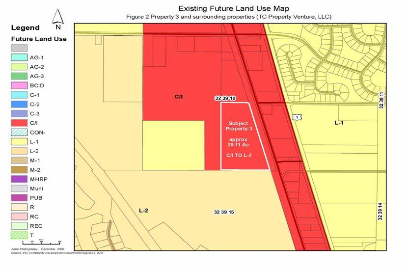
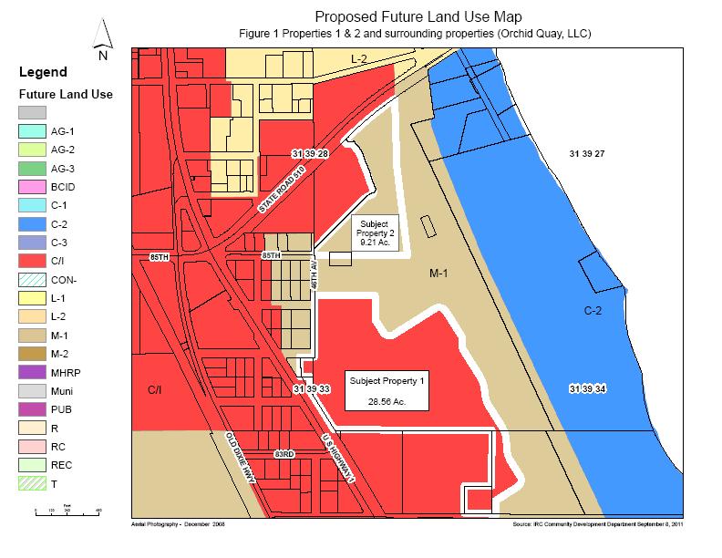
2 DESCRIPTION AND CONDITIONS This is a request by Orchid Quay, LLC; TC Property Adventure, LLC; and William Hunter to change the land use designation of several separate properties. Subject Property 1, depicted in Figure 1, is ± acres, is owned by Orchid Quay, LLC and William Hunter and is located approximately 900 feet south of C.R. 510, and east of 46 th Avenue and U.S. #1. Subject Property 2, depicted in Figure 1, is ± 9.21 acres located south of C.R. 510 and east of 46 th Avenue and is owned by Orchid Quay, LLC. Subject Property 3, depicted in Figure 2, is ±20.11 acres located approximately 1,300 feet south of 65 th Street and west of the Florida East Coast Railroad, and it is owned by TC Property Adventure, LLC. The purpose of this comprehensive plan land use map amendment is to expand and reconfigure the commercially designated area on the site comprising Subject Properties 1 and 2 by swapping the land use designation of Subject Property 1 with the land use designations of Subject Properties 2 and 3. This request also involves rezoning subject properties 1 and 2, as well as several other parcels owned by Orchid Quay, LLC. In this case, Subject Properties 1 and 2 are part of the overall site of the former Bristol Bay project. Bristol Bay was a acre mixed use project approved in As approved, the Bristol Bay project consisted of 497 residential units and 92,500 square feet of commercial. While a 7.56 acre commercially designated portion of the Bristol Bay project site was sold to another group several years ago, the owners of Subject Properties 1 and 2 control the remainder of the Bristol Bay site. As illustrated in the following table, this request involves changing both the land use designation and the zoning of properties 1 and 2, while changing only the land use designation for property 3. Owner Subject Property 1 Subject Property 2 Subject Property 3 Orchid Quay, LLC and Orchid Quay, LLC TC Property Venture, LLC William Hunter South of C.R. 510 and East of 46 th Avenue General Location ± 900 feet south of C.R. 510, east of 46 th Avenue and U.S. #1 ± 1300 feet south of 65 th Street and West of the FEC Railroad Size in Acres ± acres ± 9.21 acres ± acres Property Description Cleared Land, Stormwater Stormwater ponds, cleared Wetlands and isolated ponds land uplands habitat Current Land Use M-1, Medium Density C/I, Commercial/ C/I, Commercial/ Designation Residential-1 (up to 8 Industrial Industrial Proposed Land Use Designation Current Zoning Proposed Zoning units/acre) C/I, Commercial/ Industrial M-1, medium density Residential 1 (up to 8 units/acre) ±28.30 acres RM-6, Multi- Family Residential District (up to 6 units/acre), and ±0.26 acres RS-6, Single-Family Residential District (up to 6 unit/acre) CG, General Commercial District ±6.02 acres CG, General Commercial District and ±3.19 acres OCR, Office, Commercial and Residential District RM-6, Multi-Family Residential District (up to 6 units/acre) L-2, Low Density Residential - 2 (up to 6 units/acre) PD, Planned Development District PD, Planned Development District 2
, consisting of ±13.71 acres located east of U.S.")
3 Parcels Subject to Rezoning Only This request also involves rezoning 3 additional Orchid Quay, LLC owned parcels which are not part of the subject of land use amendment request. The first parcel (Parcel 1), consisting of ±13.71 acres located east of U.S. #1 and north of 82 nd Street, is proposed to be rezoned from OCR, Office, Commercial, and Residential District, to CG, General Commercial District. The second parcel (Parcel 2), consisting of ±11.26 acres located approximately 1500 feet east of U.S. #1 and North of 82 nd Street, is proposed to be rezoned from RS-1, Single-Family Residential District (up to 1 unit/acre), to CON-2, Estuarine Wetlands Conservation District (up to 1 unit/40 acres). The third parcel (Parcel 3), consisting of ±0.08 acres located east of U.S. #1 and ±150 feet south of 84 th Street, is proposed to be rezoned from CL, Limited Commercial District, to CG, General Commercial District. 3
4 4

5 5


6 Comprehensive Plan Amendment Review Procedures Although the number of plan amendments that the county may consider is not limited, the County s Comprehensive Plan regulates the frequency with which the County may amend its comprehensive plan. According to the County s Comprehensive Plan, plan amendments are limited to twice per calendar year. For that reason, the county accepts general plan amendment applications only during the window months of January and July. In this case, the subject application was submitted during the July 2011 window. Once a comprehensive plan amendment is submitted, the procedures for reviewing the amendment involve several steps. First, the Planning and Zoning Commission, as the Local Planning Agency, conducts a public hearing to review the request. The Commission has the option to recommend approval or denial of the Comprehensive Plan amendment request to the Board of County Commissioners. Following Planning and Zoning Commission action, the Board of County Commissioners conducts two public hearings. The first of those hearings is for a preliminary decision on the amendment request. At that hearing, the Board determines whether or not the amendment warrants transmittal to the state and regional review agencies for their consideration. If the Comprehensive Plan amendment is transmitted, state and regional review agencies will review the amendment as pertains to each agency s focus area. Review agencies will then send their comments directly to the county and the State Land Planning Agency. Subsequent to staff addressing any issues raised by the review agencies, a second and final Board of County Commissioners public hearing is conducted. If the Board approves the request, the approved amendment is submitted to the State Land Planning Agency and other review agencies that provided 6
7 comments. The amendment becomes effective 31 days after the State Land Planning Agency determines that the amendment package is complete and no petition is filed by an affected party. This public hearing is the first step in the comprehensive plan amendment process. At this time, the Planning and Zoning Commission must decide whether or not to recommend approval of the proposed amendments to the Board of County Commissioners. Existing Land Use Pattern Subject Property 1 Located approximately 900 feet south of C.R. 510 and east of 46 th Avenue and U.S. #1, Subject Property 1 consists of two abutting parcels owned by Orchid Quay, LLC and William Hunter, totaling ± acres in size. Of the two parcels comprising Subject Property 1, one is a ±28.30 acre parcel owned by Orchid Quay, LLC; it is zoned RM-6, Multi-Family Residential District (up to 6 units /acre). The other parcel is ±0.26 acres is owned by William Hunter, and is zoned RS-6, Single-Family Residential District (up to 6 units/acre). Subject Property 1 is cleared land. To the south of Subject Property 1 is vacant land belonging to the same owner (Orchid Quay, LLC) and zoned OCR, Office, Commercial and Residential District. That parcel is proposed to be rezoned to CG, General Commercial District. To the east and north of the Subject Property 1, the abutting properties are also owned by Orchid Quay, LLC and are zoned RM-6 and are vacant, while the abutting properties to the west of Subject Property 1 are zoned RS-6 and RM-6 and contain homes and vacant residential lots that are part of the Graves Addition to Wabasso Florida Subdivision. Properties to the southwest of Subject Property 1 are zoned CL, Limited Commercial District, and OCR, Office, Commercial, Residential District, and are vacant. A ±0.08 acre property to the west of Subject Property 1, owned by Orchid Quay, LLC, is zoned CL, and is proposed to be rezoned to CG, General Commercial District. Subject Property 2 Located South of C.R. 510 and east of 46 th Avenue, Subject Property 2 is zoned CG, General Commercial District, and OCR, Office, Commercial, and Residential District, and totals ±9.21 acres. While Subject Property 2 has been cleared and contains stormwater ponds, it is otherwise undeveloped. The abutting properties to the north and west of the Subject Property 2 are vacant lands that are zoned CG. To the south and east of Subject Property 2 is the remaining portion of the parent parcel which is undeveloped and is zoned RM-6. Subject Property 3 Subject Property 3 is located approximately 1300 feet south of 65 th Street and west of the FEC Railroad, is owned by TC Property Venture, LLC, and totals ±20.11 acres. This property consists predominantly of wetlands with isolated areas of upland habitat containing pinetrees, oak trees and palmetto. The property also contains scrub jay and gopher tortoise habitat. Subject Property 3 and properties to the north and west of Subject Property 3 are owned by the same owner, are zoned PD and are wooded, undeveloped tracts. To the east is the Florida East Coast Railroad, and to the south is the RM-4, Multi-Family Residential District (up to 4 units/acre), zoned Hawks Nest golf course. 7
8 Parcels Subject to Rezoning Only Besides the three properties that are the subject of this comprehensive plan land use map amendment, there are three other properties proposed for rezoning with no associated comprehensive plan land use map designation amendment. All of those properties are part of the overall former Bristol Bay site. Each of the rezoning parcels is described below. Located east of U.S. #1, north of 82 nd Street, and south of Subject Property 1, Subject Parcel 1 is ±13.71 acres and is proposed to be rezoned from OCR to CG. Properties to the west of Subject Parcel 1 are zoned OCR and CL. Located ±1500 feet east of U.S. #1 and north of 82 nd Street, Subject Parcel 2 is ±11.26 acres and is proposed to be rezoned from RS-1 to Con-2. Properties to the north and south of Subject Parcel 2 are zoned RS-1, while properties to the west are zoned RM- 6. Located east of U.S. #1 and ±150 feet south of 84 th Street, Subject Parcel 3 is ±0.08 acres and is proposed to be rezoned from CL to CG. Properties to the north of Parcel 3 are zoned RS-6, while those to the west are zoned CL, and those to the east are zoned RM-6. Future Land Use Pattern Subject Property 1 Subject Property 1 and the properties to the north, east, and west are designated M-1, Medium- Density Residential-1 (up to 8 units/acre), on the county s future land use map. The M-1 designation permits residential uses with densities up to 8 units/acre. Land to the south and southwest of Subject Property 1 is designated C/I, Commercial/Industrial, on the county s future land use map. The C/I designation permits various commercial and industrial zoning districts. Subject Property 2 Subject Property 2 and parcels to the west and north have a land use designation of C/I, Commercial/Industrial. Land to the south and east of Subject Property 2 is designated M-1, Medium-Density Residential-1, on the county s future land use map. Subject Property 3 Subject Property 3 and lands to the east, west, and north have a land use designation of C/I, Commercial/Industrial. Land to the south of Subject Property 3 has an L-2, Low-Density Residential 2, land use designation. The L-2 designation permits residential uses with a density of up to 6 units/acre. Parcels Subject to Rezoning Only Subject Parcels 1 and 3 are designated C/I, Commercial and Industrial, while Subject Parcel 2 is designated C-2, Conservation 2 (privately owned estuarine wetland). 8
9 Environment Subject Property 1 Subject Property 1 has previously been cleared and currently contains several stormwater ponds. No natural wetlands or any other environmentally sensitive habitat exist on the property. According to Flood Insurance Rating Maps, subject property 1 is within AE and X 500 flood hazard areas. Subject Property 2 Subject Property 2 has previously been cleared and currently contains stormwater ponds. No natural wetlands or any other environmentally sensitive habitat exist on the site. According to Flood Insurance Rating Maps, Subject Property 2 is within an AE flood hazard area. Subject Property 3 Subject Property 3 consists predominately of wetlands with isolated areas of upland habitat containing pine trees, oak trees and palmetto. The property also contains scrub jay and gopher tortoise habitat. According to Flood Insurance Rating Maps, Subject Property 3 is within Zone X, and does not contain any flood hazard area. Parcels Subject to Rezoning Only Subject Parcels 1 and 3 are cleared land. Subject Parcel 2 contains estuarine wetlands. Utilities and Services Subject Properties 1, 2, and 3, as well as parcels 1, 2, and 3, are all within the Urban Service Area of the County. Wastewater service is available to these sites from the North County Regional Wastewater Treatment Plant, while potable water service is available from the North County Reverse Osmosis Plant. Transportation System Subject Property 1 Subject Property 1 is part of a larger property which has access to C.R. 510, a roadway classified as an Urban Minor Arterial on the County s Thoroughfare Plan Map, and U.S. #1, an Urban Principal Arterial. The segment of C.R. 510 adjacent to the overall parent parcel of Subject Property 1 is a two lane paved road with approximately 120 feet of existing public road right-of-way. At this time, no additional right-of-way is needed. The segment of U.S. #1 adjacent to Subject Property 1 is a 4 lane paved road with 120 feet of road right of way. For that segment of U.S. #1, there is a need for 40 feet of additional right of way. To the south, the parent property abuts 82 nd Street, an unpaved local road. The property s west boundary abuts 46 th Avenue which also is an unpaved local road. Subject Property 2 9
10 Subject Property 2 is part of a larger property which has frontage on C.R That segment of C.R. 510 is a two lane paved road with approximately 120 feet of existing public road right of way. At this time, no additional right of way is needed for C.R Subject Property 3 Subject Property 3 is part of a larger property that abuts 65 th Street. The segment of 65 th Street which is adjacent to Subject Property 3 is a 2 lane Major Collector roadway with 35 feet of right of way. That roadway needs an additional 45 feet of right of way. Parcels Subject to Rezoning Only Parcels 1, 2, and 3, as part of the parent parcel have access to C.R. 510, U.S. #1, 82 nd Street, and 46 th Avenue. ANALYSIS In this section, an analysis of the reasonableness of the application will be presented. Following a discussion of plan amendment review standards, this section will include the following: An analysis of the proposed amendment s impact on the land use pattern; An analysis of the proposed amendment s impact on public facilities; An analysis of the proposed amendment s compatibility with surrounding areas; An analysis of the proposed amendment s consistency with the comprehensive plan; and An analysis of the proposed amendment s potential impact on environmental quality. Plan Amendment Review Standards Unlike most land use map designation amendment requests, this request does not involve an increase in land use density or intensity. As proposed, the request involves a reconfiguration, rather than an expansion, of commercial/industrial nodes. For that reason, the subject request can be characterized differently from most plan amendments. Typically, plan amendments involve increases in allowable density or intensity of development. As such, the typical amendment would result in impacts on public facilities and changes to land use patterns. Consequently, both the county comprehensive plan and state policy dictate that a high standard of review is required for typical plan amendments. That standard of review requires justification for the proposed change based upon adequate data and analysis. The subject amendment, however, differs significantly from a typical plan amendment request. Instead of proposing density or intensity increases, the subject amendment involves only a locational shift in future land uses without an increase in land use density or intensity. Staff s position is that this type of Future Land Use Map amendment warrants a different standard of review. Since the typical type of amendment can be justified only by challenging the projections, need assessments, and standards used to prepare the original plan, a high standard of review is 10
11 justified. For amendments involving just shifts in land uses and no intensity/density increase, less justification is necessary. That recognizes that no single land use plan map is correct, and that many variations may conform to accepted land use principles and meet established plan policies. In March 1998, the county amended its comprehensive plan to specifically allow future land use map amendments that do not increase the county s overall land use density or intensity. That change was recommended in the county s first adopted Evaluation and Appraisal Report (EAR), which was found sufficient by DCA. EAR based amendments, including that recommendation, were adopted by the county and found in compliance by DCA. Land Use Pattern As proposed, the subject comprehensive plan land use amendment and associated rezonings will enhance land use efficiency in the County. While the amendment involves increasing the commercial area on the former Bristol Bay site, that increase is being offset by a reduction of commercial area on Subject Property 3 and another portion of the former Bristol Bay site. In essence, commercial/industrial designation is being moved from areas where commercial/industrial use is less feasible to an area where it is more feasible. With the commercial reconfiguration reflected in the subject land use map amendment and rezonings, the former Bristol Bay property can be site planned in a more efficient manner. In this case, the proposed changes still allow for the Bristol Bay site to be developed as a mixed use project, a project type encouraged by the county. In fact, the land use reconfiguration reflected in the proposed amendment may actually increase the prospects for the Bristol Bay site to be developed as a mixed use project. Generally, the reconfiguration of land use designations on a large property is appropriate. In this case, the reconfiguration will consolidate the commercial area on the south part of the property and provide a U.S. #1 orientation. To the extent that such a land use modification can reflect market conditions while still meeting county planning objectives, then such amendment should be approved. Concurrency of Public Facilities All sites comprising this request are located within the County Urban Service Area, an area deemed suited for urban scale development. The comprehensive plan establishes standards for: Transportation, Potable Water, Wastewater, Solid Waste, Stormwater Management, Public Schools, and Recreation (Future Land Use Policy 3.1). The adequate provision of these services is necessary to ensure the continued quality of life enjoyed by the community. To ensure that the minimum acceptable standards for these services and facilities are maintained, the comprehensive plan requires that new development be reviewed for a concurrency determination. For land use designation amendment requests, this review is undertaken as part of the conditional concurrency determination application process. As per section of the County s Land Development Regulations (LDRs), conditional concurrency review examines the available capacity of each facility with respect to a proposed project. Since land use amendment requests are not projects, county regulations call for the concurrency review to be based upon the most intense use of the subject property based upon the requested land use designation. 11
12 For commercial/industrial land use amendment requests, the most intense use (according to County LDRs) is retail commercial with 10,000 square feet of gross floor area per acre of land proposed for redesignation. For residential land use amendment requests, the most intense use (according to County LDRs) is the maximum number of units that could be built on the site, given the size of the property and the maximum density under the proposed land use designation. The site information used for the concurrency analysis of subject properties 1, 2, and 3 of the proposed amendment, is as follows: Subject Property 1 1. Size of Area to be Redesignated: ± acres 2. Existing Land Use Designation: M-1, Medium-Density Residential-1 (up to 8 units/acre) 3. Most Intense Use with Existing Land Use Designation: 228 units 4. Proposed Land Use Designation: C/I, Commercial/ Industrial 5. Most Intense Use with Proposed Land Use Designation: 285,600 square feet of Retail Commercial Subject Property 2 1. Size of Area to be Redesignated: ± 9.21 acres 2. Existing Land Use Designation: C/I, Commercial/ Industrial 3. Most Intense Use with Existing Land Use Designation: 92,100 square feet of Retail Commercial 4. Proposed Land Use Designation: M-1, Medium-Density Residential-1 (up to 8 units/acre) 5. Most Intense Use with Proposed Land Use Designation: 73 units Subject Property 3 1. Size of Area to be Redesignated: ± acres 2. Existing Land Use Designation: C/I, Commercial/ Industrial 12
13 3. Most Intense Use with Existing Land Use Designation: 201,100 square feet of Retail Commercial 4. Proposed Land Use Designation: L-2, Low-Density Residential-2 (up to 6 units/acre) 5. Most Intense Use with Proposed Land Use Designation: 120 units Concurrency Summary: Subject Property Retail/Commercial Residential Existing Proposed Existing Proposed ,600 sq. ft. 228 units ,100 sq. ft units 3 201,100 sq. ft units Total 293,200 sq. ft. 285,600 sq. ft. 228 units 193 units Change from - 7,600 square feet - 35 units Existing As stated in the description and conditions section of this staff report, this request also involves rezoning of 3 parcels which are not subject to land use amendment. Two of the parcels that are proposed for rezoning without a comprehensive plan land use amendment are being changed from one commercial zoning district to another commercial zoning district. Therefore, the most intense use for those two parcels will not change due to the requested rezonings. The third rezoning parcel is changing from RS-1, up to 1 unit/acre, to CON-2, up to 1 unit/40 acres, resulting in a net density reduction. Consequently, these three rezonings will not increase the density or intensity of the uses and will not have any additional public facility impacts. With the proposed comprehensive plan land use amendment, the total square footage of commercial that could be developed on all three properties will be reduced by 7,600 square feet, while the total residential yield will decline by 35 units. As per section (2) of the Concurrency Management Chapter of the County s LDRs, projects which do not increase density or intensity of use are exempt from concurrency requirements. This land use amendment and associated rezoning requests are exempt from concurrency review because the requested land use designation changes and rezonings will actually decrease the allowable square footage of retail commercial uses and the total number of potential units that all subject sites could accommodate. It is important to note that there will be no effect on service levels for any public facility as a result of these land use designation amendments. As with all projects, a detailed concurrency analysis will be done in conjunction with site development. That concurrency analysis will address facility service levels and demand. Compatibility with the Surrounding Area 13
14 Subject Property 1 According to county land use policy, sites such as the Orchid Quay, LLC property that front on major roads and are a part of a larger project may be appropriate for a C/I land use designation. Not all property fronting major roads, however, is appropriate for a commercial land use designation. For that reason, the county has various commercial land use policies that dictate where C/I is appropriate. In this case, the proposed C/I designation for Subject Property 1 is appropriate because there will be no overall increase in C/I designated land, because Subject Property 1 is adjacent to other C/I designated land, because the proposed C/I land use is part of an overall site that can be developed as a mixed use project, and because the C/I designation will not create strip commercial development. Since Subject Property 1 is part of a larger tract of land owned by the same owner and since land to the south and southwest of the Subject Property 1 is currently designated C/I, there will be no compatibility problems between those properties and the requested C/I land use designation of the subject property 1. To the west of Subject Property 1, across 46 th Avenue, some of the properties have an M-1, Medium-Density Residential-1 (up to 8 units/acre), land use designation and contain residential units and vacant residential lots as part of the Graves Addition to Wabasso Florida Subdivision. Although that group of M-1 designated properties is already bordered by C/I designated land on two sides, those properties could potentially be impacted by changing Subject Property 1 to commercial. In this case, however, there are only a few residences in the area, and this general area of the county is mixed with residential and commercial uses. Regardless, any commercial development on the property will be designed to mitigate impacts on adjacent residential properties through the use of setbacks, vegetative buffers, and other design elements. Given Subject Property 1 s location and relation to adjacent uses, it is staff s position that redesignating Subject Property 1 to C/I and rezoning Subject Property 1 to CG will create no incompatibilities with neighboring properties. Subject Property 2 Subject Property 2 is part of a larger tract of land that is owned by the same owner and contains stormwater ponds related to the entire project. To the south and east of the proposed area to be redesignated, properties are designated as M-1, Medium Density Residential 1. Therefore, the proposed M-1 land use designation is a continuation of that land use designation, and no compatibility problems are anticipated. Subject Property 3 Subject Property 3 is part of a larger parcel owned by the same owner and zoned PD, Planned Development District. Since the property to the south of Subject Property 3 has an L-2 land use designation and the proposal is to change Subject Property 3 to L-2, the requested land use will be a continuation of the land use designation to the south. Because Subject Property 3 is adjacent to the 14
15 Florida East Coast Railroad and because properties to the north and west are part of the larger tract owned by the same owner, no compatibility issues are anticipated. In this case, Subject Property 3 is part of the High Point planned development project. Even though Subject Property 3 has a C/I land use designation, its underlying PD zoning allows only residential development. In such cases, the controlling land use designation may be either residential or commercial/industrial. As a result, the land use designation change for Subject Property 3 from C/I to L-2 will not change the underlying PD zoning and current development allowances, thereby further ensuring compatibility with adjacent properties. Parcels Subject to Rezoning Only Parcels 1 and 3 are proposed to be rezoned from one commercial zoning district to another commercial zoning district. Since Parcels 1 and 3 are part of the parent parcel, are adjacent to U.S.#1, and are adjacent to other commercial zoning districts; either their current zoning or proposed CG zoning is appropriate for those sites. Therefore, no compatibility issues are anticipated with the proposed rezoning. Parcel 2 is proposed to be rezoned to CON-2, Conservation 2; therefore, no compatibility issues are anticipated. In the case of Parcel 2, the property s land use designation is C-2. According to the county s comprehensive plan, sites having a C-2 designation shall be rezoned to CON-2 at the time of development approval when estuarine wetland boundaries can be determined. Since other portions of the overall site are being redesignated and rezoned, it is appropriate to rezone Parcel 2 to CON-2 at this time. With a conservation zoning, Parcel 2 will be compatible with all adjacent properties. For those reasons, staff feels that the proposed land use designations and rezonings will be compatible with surrounding properties. Consistency with Comprehensive Plan Land use amendment and rezoning requests are reviewed for consistency with all appropriate policies of the comprehensive plan. As per section (1) of the land development regulations, the comprehensive plan may only be amended in such a way as to preserve the internal consistency of the plan pursuant to Section (2), FS. Amendments must also show consistency with the overall designation of land uses as depicted on the Future Land Use Map, which includes agricultural, residential, recreational, conservation, and commercial and industrial land uses and their densities. The goals, objectives and policies are the most important parts of the comprehensive plan. Policies are statements in the plan which identify actions which the county will take in order to direct the community s development. As courses of action committed to by the county, policies provide the basis for all county land development related decisions--including plan amendment and rezoning decisions. While all comprehensive plan objectives and policies are important, some have more applicability than others in reviewing plan amendment and rezoning requests. Of particular applicability for this request are the following policies. 15
16 Future Land Use Element Policy 14.3 In evaluating a land use amendment request, the most important consideration is Future Land Use Element Policy This policy requires that one of four criteria be met in order to approve a land use amendment request. These criteria are: The proposed amendment will correct a mistake in the approved plan; The proposed amendment will correct an oversight in the approved plan; The proposed amendment is warranted based on a substantial change in circumstances affecting the subject property; or The proposed amendment involves a swap or reconfiguration of land use designations at separate sites and, that swap or reconfiguration will not increase the overall land use density or intensity depicted on the Future Land Use Map. In this case, the proposed amendment meets the policy s fourth criterion. As specifically cited in the policy, the proposed amendment involves a swap or reconfiguration of land use designations at separate sites, and that swap or reconfiguration will not increase the overall land use density or intensity depicted on the Future Land Use Map. For those reasons, the proposed amendment meets the fourth criterion of Future Land Use Element Policy Because the proposed amendment meets the policy s fourth criterion, the proposed amendment is consistent with Future Land Use Element Policy Future Land Use Element Policies 1.11 and 1.12 Future Land Use Element Policies 1.11 and 1.12 state that the L-2, Low-Density Residential-2, land use designation should be within the urban service area and is intended for urban and suburban scale residential development with densities up to 6 units/acre. Located within the urban service area, Subject Property 3 is appropriate for residential development with a density of up to 6 units/acre. Since the proposed amendment would allow that type of low density residential development on Subject Property 3, the proposed amendment is consistent with Future Land Use Element Policies 1.11 and Future Land Use Element Policies 1.13 and 1.14 Future Land Use Element Policies 1.13 and 1.14 state that the M-1, Medium-Density Residential-1, land use designation should be within the urban service area and is intended for urban and suburban scale residential development with densities up to 8 units/acre. Located within the urban service area, Subject Property 2 is appropriate for residential development with a density of up to 8 units/acre. Since the proposed amendment would allow that type of 16
17 medium density residential development on Subject Property 2, the proposed amendment is consistent with Future Land Use Element Policies 1.13 and Future Land Use Element Policy 1.17 Future Land Use Element Policy 1.17 states that the Commercial/Industrial land use designation should be within the urban service area and in areas that are suitable for urban scale development. Since Subject Property 1 as well as Parcels 1 and 3 which are subject to rezoning only, are located within the urban service area and since the proposed amendment would allow commercial development on Subject Property 1, the proposed amendment is consistent with Future Land Use Element Policy Future Land Use Element Policy 1.22 Future Land Use Element Policy 1.22 states that nodes shall have a designated size based on the intended use, service area population, existing land use pattern and other demand characteristics. The amount of C/I designated land is based on service area population, the existing land use pattern, and other demand characteristics. In this case, the proposed amendment will not alter the amount of C/I designated land. Therefore, the proposed amendment of the Subject Property 1 is consistent with Future Land Use Element Policy Future Land Use Element Policy 1.24 Future Land Use Element Policy 1.24 states that 70% of the land area of a node should be developed with non-residential and non-agricultural uses before that node is considered for expansion unless other wise warranted. Unless warranted includes a land use amendment whereby the expansion of a node is necessary to facilitate a swap of land use designations and that swap of land does not increase the overall land use density or intensity as depicted on the future land use map. The intent of this policy is to regulate increases in the amount of C/I designated land. Since the proposed amendment involves a land use designation swap that does not increase the density or intensity as depicted on the future land use map, the proposed amendment is consistent with Future Land Use Element Policy Future Land Use Element Policies 1.5 and 1.6 Future Land Use Element Policy 1.5 states that the conservation land use designation is applied to those areas which are vital or essential to the normal functions of ecosystems and have been identified in the Conservation Element as meriting preservation. Future Land Use Element Policy 1.6 limits the use of C-2 designated land to conservation and passive recreational uses, and residential uses up to 1 unit/40 acres. As privately owned sites containing wetlands and/or native upland habitat, the Subject Parcel 2 meets the criteria of Policies 1.5 and 1.6. For this reason, the request is consistent with Future Land Use Element Policies 1.5 and 1.6. As part of the staff analysis, all relevant policies in the comprehensive plan were considered. Based upon that analysis, staff determined that the proposed land use designation amendments and rezoning requests are consistent with the county s comprehensive plan. 17
18 Potential Impact on Environmental Quality Subject Property 1 Subject Property 1 is an altered site which contains no environmentally important land, such as wetlands or sensitive uplands. Thus, development of the site is anticipated to have little or no impact on environmental quality. Overall, the environmental impact will be the same for development under the requested C/I land use designation as it would be for development under the present M-1 land use designation. For that reason, no adverse environmental impacts associated with this request are anticipated. Subject Property 2 Subject Property 2 is an altered site. Overall, the environmental impact will be the same for development under the requested M-1 land use designation and the present C/I land use designation. Therefore, no additional adverse environmental impacts associated with this request are anticipated. Subject Property 3 Subject Property 3 contains wetlands and isolated areas of upland habitat. Under the requested low density residential land use designation, development on the property will be less intense than development allowed under the property s current commercial/industrial land use designation. In this case, wetland and upland protection measures will be the same for both the current and the proposed land use designation. Therefore, no additional adverse environmental impacts associated with this request are anticipated. Parcels Subject to Rezoning Only Parcels 1 and 3 are cleared land, therefore, no additional environmental impacts are anticipated. Parcel 2 is proposed to be rezoned to CON-2, Conservation District which enhances the property s environmental protection. For those reasons, the proposed amendments and rezonings are not anticipated to adversely impact environmental quality. 18
19 CONCLUSION The proposed Future Land Use Map amendments and rezoning requests are consistent with the comprehensive plan, compatible with all surrounding land uses, and will cause no adverse impacts on the environment or the provision of public services. The proposed changes will increase land use efficiency and facilitate economic development. For those reasons, staff supports the request. RECOMMENDATION Based on the analysis, staff recommends that the Planning and Zoning Commission recommend that the Board of County Commissioners approve the proposed future land use map amendments for transmittal to the State and Regional review agencies. Staff also recommends that the Planning and Zoning Commission recommend that the Board of County Commissioners approve the proposed rezoning requests ATTACHMENTS 1. Summary Pages 2. Land Use Amendments and Rezoning Requests Applications 19
20 SUMMARY PAGE Subject Property 1 GENERAL Applicant: Orchid Quay, LLC and William Hunter Location: ±900 feet south of C.R. 510, and east of 46 th Avenue and U.S. #1 Acreage: ±28.56 acres Existing Land Use Designation: M-1, Medium-Density Residential-1 (up to 8 units/acre) Requested Land Use Designation: C/I, Commercial/Industrial Existing Zoning: RM-6, Multi-Family Residential District (up to 6 units/acre) Requested Zoning: CG, General Commercial District Existing Land Use: Vacant, cleared land ADJACENT LAND North & East: RM-6, Multi-Family Residential District (up to 6 units/acre) South: OCR, Office, Commercial, Residential District West: RS-6, Single-Family Residential District (up to 6 units/acre), CL, Limited Commercial District, and OCR District INFRASTRUCTURE Water and sewer available ENVIRONMENTAL CONSTRAINTS None PUBLIC NOTIFICATION Staff Contact: Date Advertised: # of Surrounding Property Owner Notification s: Date Notification Mailed: Date Sign Posted: Planning and Zoning Commission Sasan Rohani September 7, September 7, 2011 September 7, 2011 Board of County Commissioners STAFF RECOMMENDATION Staff supports the request Attachment 1 20
 Existing Zoning: OCR")
 East: RM-6, Multiple-Family Residential (up to 6 units/acre) West: CG, General Commercial INFRASTRUCTURE Water and")

21 SUMMARY PAGE Subject Property 2 GENERAL Applicant: Orchid Quay, LLC Location: South of C.R. 510 and East of 46 th Avenue Acreage: ±9.21 acres Existing Land Use Designation: C/I, Commercial/Industrial Requested Land Use Designation: M-1, Medium-Density Residential-2 (up to 8 units/acre) Existing Zoning: OCR and CG Requested Zoning: RM-6, Multi-Family Residential District (up to 6 units/acre) Existing Land Use: Vacant, stormwater ponds ADJACENT LAND North: CG, General Commercial South: RM-6, Multi-Family Residential (up to 6 units/acre) East: RM-6, Multiple-Family Residential (up to 6 units/acre) West: CG, General Commercial INFRASTRUCTURE Water and sewer available ENVIRONMENTAL CONSTRAINTS None PUBLIC NOTIFICATION Staff Contact: Date Advertised: # of Surrounding Property Owner Notifications : Date Notification Mailed: Date Sign Posted: Planning and Zoning Commission Sasan Rohani September 7, September 7, 2011 September 7, 2011 Board of County Commissioners STAFF RECOMMENDATION Staff supports the request SUMMARY PAGE Attachment 1
 Existing Zoning: PD, Planned Development")
 INFRASTRUCTURE Water and sewer available")

22 Subject Property 3 GENERAL Applicant: TC Property Venture Location: ±1300 feet south of 65 th Avenue and west of the FEC Railroad Acreage: ±20.11 acres Existing Land Use Designation: C/I, Commercial/Industrial Requested Land Use Designation: L-2, Low-Density Residential-2 (up to 6 units/acre) Existing Zoning: PD, Planned Development District Requested Zoning: PD, Planned Development District Existing Land Use: Vacant, Wetlands, Upland ADJACENT LAND North: PD, Planned Development District West: PD, Planned Development District East: Florida East Coast Railroad and IL, Light Industrial South: Hawk s Nest Golf Club; zoned RM-4, Multi-Family Residential (up to 4 units/acre) INFRASTRUCTURE Water and sewer available ENVIRONMENTAL CONSTRAINTS None PUBLIC NOTIFICATION Staff Contact: Date Advertised: # of Surrounding Property Owner Notifications : Date Notification Mailed: Date Sign Posted: Planning and Zoning Commission Sasan Rohani September 7, September 7, 2011 September 7, 2011 Board of County Commissioners STAFF RECOMMENDATION Staff supports the request Attachment 1 F:\Community Development\Comprehensive Plan Land Use Amendments\Orchid Quay, Highpointe, William Hunter- July 2011\Staff Reports\PZC agenda item staff report - september 22, 2011.doc
23
24
25
26
27
28
29
30
31
32
33
TREASURE COAST REGIONAL PLANNING COUNCIL M E M O R A N D U M. February 19, 2010 Regional Planning Council Meeting
 TREASURE COAST REGIONAL PLANNING COUNCIL M E M O R A N D U M To: Council Members AGENDA ITEM 5G From: Date: Subject: Staff February 19, 2010 Regional Planning Council Meeting Local Government Comprehensive
Marion County Board of County Commissioners
 Marion County Board of County Commissioners Date: 6/4/217 P&Z: 9/25/217 BCC Transmittal: 1/17/217 BCC Adopt: TBD Amendment No: 217-L6 Type of Application Large-Scale Comp Plan Amendment Request: Change
TREASURE COAST REGIONAL PLANNING COUNCIL M E M O R A N D U M
 TREASURE COAST REGIONAL PLANNING COUNCIL M E M O R A N D U M To: Council Members AGENDA ITEM 6A From: Date: Subject: Staff May 20, 2011 Council Meeting Local Government Comprehensive Plan Review Draft
TREASURE COAST REGIONAL PLANNING COUNCIL M E M O R A N D U M. To: Council Members AGENDA ITEM 10A
 TREASURE COAST REGIONAL PLANNING COUNCIL M E M O R A N D U M To: Council Members AGENDA ITEM 10A From: Date: Subject: Staff April 20, 2007 Council Meeting Local Government Comprehensive Plan Review Draft
Cover Letter with Narrative Statement
 Cover Letter with Narrative Statement March 31, 2017 rev July 27, 2017 RE: Rushton Pointe Residential Planned Unit Development Application for Public Hearing for RPUD Rezone PL2015 000 0306 Mr. Eric Johnson,
COMPREHENSIVE PLAN FUTURE LAND USE MAP AMENDMENT APPLICATION
 COUNTY STAFF DATA ONLY Date Received: Project No. CPA-20 - GADSDEN COUNTY DEPARTMENT OF PLANNING & COMMUNITY DEVELOPMENT 1-B East Jefferson Street, Post Office Box 1799, Quincy, FL 32353-1799 PLANNING
31, Township 29 South, Range 25 East, Polk County, Florida, as depicted by the Land Use Plan attached
 ORDINANCE NO. 2013-04 AN ORDINANCE AMENDING THE ZONING MAP OF THE CITY OF BARTOW, FLORIDA, REZONING APPROXIMATELY 2. 2 ACRES OF LAND OWNED BY BALA3I OF POLK COUNTY, LLC AND LOCATED IN SECTION 31, TOWNSHIP
Town of Cary, North Carolina Rezoning Staff Report 14-REZ-31 Cary Park PDD Amendment (Waterford II) Town Council Meeting January 15, 2015
 Town Council Meeting January 15, 2015") Town of Cary, North Carolina Rezoning Staff Report 14-REZ-31 Cary Park PDD Amendment (Waterford II) Town Council Meeting January 15, 2015 REQUEST To amend the Town of Cary Official Zoning Map by amending
Town of Cary, North Carolina Rezoning Staff Report 14-REZ-31 Cary Park PDD Amendment (Waterford II) Town Council Meeting January 15, 2015 REQUEST To amend the Town of Cary Official Zoning Map by amending
Glades County Staff Report and Recommendation REZONING
 Glades County Staff Report and Recommendation REZONING CASE NUMBER: RZ15-01 DATE: October 2, 2015 CASE TYPE: Application for Rezoning REQUEST: J.J. Wiggins Memorial Trust is requesting a rezoning of 22.1±
PALM BEACH COUNTY PLANNING, ZONING AND BUILDING DEPARTMENT ZONING DIVISION
 PALM BEACH COUNTY PLANNING, ZONING AND BUILDING DEPARTMENT ZONING DIVISION Application No.: Z-2014-01627 Application Name: Dazco Center Control No.: 2003-00040 Applicant: 4730 Hypoluxo LLC Owners: 4730
AGENDA ITEM SUMMARY GLADES COUNTY BOARD OF COUNTY COMMISSIONERS
 AGENDA ITEM SUMMARY GLADES COUNTY BOARD OF COUNTY COMMISSIONERS SUBJECT: Case Number COMP17-01, Legend Moto LLC This is a Legislative Hearing. DEPARTMENT REQUEST: The Community Development Department requests
TREASURE COAST REGIONAL PLANNING COUNCIL M E M O R A N D U M. To: Council Members AGENDA ITEM 9D
 TREASURE COAST REGIONAL PLANNING COUNCIL M E M O R A N D U M To: Council Members AGENDA ITEM 9D From: Date: Subject: Staff May 15, 2015 Council Meeting Local Government Comprehensive Plan Review Draft
PALM BEACH COUNTY PLANNING, ZONING AND BUILDING DEPARTMENT ZONING DIVISION
 PALM BEACH COUNTY PLANNING, ZONING AND BUILDING DEPARTMENT ZONING DIVISION Application No.: DOA-2014-01111 Application Name: World Class Academy Control No.: 1998-00052 Applicant: World Class Academy Inc
City File ZM th Street North St. Petersburg, FL Central Avenue, Suite 1600 St. Petersburg, FL 33701
 Staff Report to the St. Petersburg Community Planning & Preservation Commission Prepared by the Planning & Development Services Department, Urban Planning and Historic Preservation Division For Public
CITY OF PALM BEACH GARDENS CITY COUNCIL Agenda Cover Memorandum Meeting Date: November 1, 2018 Ordinance 24, 2018 / *Ordinance 25, 2018
 CITY OF PALM BEACH GARDENS CITY COUNCIL Agenda Cover Memorandum Meeting Date: November 1, 2018 Subject/Agenda Item: 11940 U.S. Highway One Small-Scale Comprehensive Plan Future Land Use Map Amendment and
Glades County Staff Report and Recommendation Unified Staff Report for Small Scale Plan Amendment and Rezoning
 Glades County Staff Report and Recommendation Unified Staff Report for Small Scale Plan Amendment and Rezoning CASE NUMBERS: COMP17-02 and RZ17-02 DATE of STAFF REPORT: May 1, 2017 CASE TYPE: Application
Nassau County Department of Planning & Economic Opportunity Nassau Place Yulee, Florida 32097
 Nassau County Department of Planning & Economic Opportunity 96161 Nassau Place Yulee, Florida 32097 APPLICATION AND INSTRUCTIONS FOR FUTURE LAND USE MAP AMENDMENT (TEN (10) ACRES OR MORE) NOTICE: Florida
1. Future Land Use FLU6.6.8 Land uses within the Rural Service Area portion of the Wekiva Study Area shall be limited to very low and low intensity
 1. Future Land Use FLU6.6.8 Land uses within the Rural Service Area portion of the Wekiva Study Area shall be limited to very low and low intensity uses to the greatest extent possible. Existing land uses
Planning Department Oconee County, Georgia STAFF REPORT
 Planning Department Oconee County, Georgia STAFF REPORT REZONE CASE #: 7332 DATE: November 28, 2017 STAFF REPORT BY: Gabriel Quintas, Planner APPLICANT NAME: Smith Planning Group PROPERTY OWNER: John Hadden
PLANNING COMMISSION REPORT Regular Agenda -Public Hearing Item
 PDP-13-00518 Item No. 3B- 1 PLANNING COMMISSION REPORT Regular Agenda -Public Hearing Item PC Staff Report 2/24/14 ITEM NO. 3B PRELIMINARY DEVELOPMENT PLAN FOR HERE @ KANSAS; 1101 INDIANA ST (SLD) PDP-13-00518:
REZONING APPLICATION INSTRUCTIONS
 REZONING APPLICATION INSTRUCTIONS All required information, as stated on the Rezoning Application Checklist, must be included to qualify as a complete application. Upon receipt, staff will review the application
Chapter 100 Planned Unit Development in Corvallis Urban Fringe
 100.100 Scope and Purpose. Chapter 100 Planned Unit Development in Corvallis Urban Fringe (1) All applications for land divisions in the Urban Residential (UR) and Flood Plain Agriculture (FPA) zones within
Plans shall be drawn at a readable scale, signed, and sealed by a Florida Registered Engineer. The application package shall include:
 CHAPTER 400. SECTION 403. PERMIT TYPES AND APPLICATIONS SITE DEVELOPMENT 403.3. Preliminary Site Plans (PSP) A. Intent and Purpose PSPs are used to identify existing site conditions and demonstrate general
ATTACHMENT #1 SUMMARY CHART
 ATTACHMENT #1 SUMMARY CHART Item # Amendment To: Nature of Proposed Amendment PCM201801 PCM201802 PCM201803 PCM201804 LMA201802 LMA201803 LMA201804 PCT201801 PCT201802 PCT201803 FUTURE LAND USE MAP Parkway
Town of Cary, North Carolina Rezoning Staff Report 14-REZ-20 Habitat for Humanity Evans Road Town Council Meeting October 16, 2014
 Town of Cary, North Carolina Rezoning Staff Report 14-REZ-20 Habitat for Humanity Evans Road Town Council Meeting October 16, 2014 REQUEST To amend the Town of Cary Official Zoning Map by rezoning 0.53
AGENDA ITEM SUMMARY GLADES COUNTY BOARD OF COUNTY COMMISSIONERS
 AGENDA ITEM SUMMARY GLADES COUNTY BOARD OF COUNTY COMMISSIONERS SUBJECT: Case Number COMP17-02, RFYC, LLC This is a Legislative Hearing. DEPARTMENT REQUEST: The Community Development Department requests
ARTICLE 14 PLANNED UNIT DEVELOPMENT (PUD) DISTRICT
 DISTRICT") ARTICLE 14 PLANNED UNIT DEVELOPMENT (PUD) DISTRICT Section 14.01 Intent. It is the intent of this Article to allow the use of the planned unit development (PUD) process, as authorized by the Michigan Zoning
ARTICLE 14 PLANNED UNIT DEVELOPMENT (PUD) DISTRICT Section 14.01 Intent. It is the intent of this Article to allow the use of the planned unit development (PUD) process, as authorized by the Michigan Zoning
FUTURE LAND USE ATLAS AMENDMENT STAFF REPORT AMENDMENT ROUND 14-1 BCC ADOPTION PUBLIC HEARING, APRIL 28, 2014
 Item: 3.A.1 FUTURE LAND USE ATLAS AMENDMENT STAFF REPORT AMENDMENT ROUND 14-1 BCC ADOPTION PUBLIC HEARING, APRIL 28, 2014 I. General Data Project Name: Burt Reynolds Ranch (LGA 2014-003) Request: Acres:
PALM BEACH COUNTY PLANNING, ZONING AND BUILDING DEPARTMENT ZONING DIVISION ZONING COMMISSION VARIANCE STAFF REPORT 06/05/2014
 PALM BEACH COUNTY PLANNING, ZONING AND BUILDING DEPARTMENT ZONING DIVISION ZONING COMMISSION VARIANCE STAFF REPORT 06/05/2014 APPLICATION NO. ZV-2013-03120 CODE SECTION REQUIRED PROPOSED VARIANCE (V1)
Community Development Department 333 Broadalbin Street SW, P.O. Box 490 Albany, OR 97321
 SUMMARY Community Development Department 333 Broadalbin Street SW, P.O. Box 490 Albany, OR 97321 STAFF REPORT Application for Tentative Partition Plat Review Planning File PA-06-17 Phone: 541-917-7550
TREASURE COAST REGIONAL PLANNING COUNCIL M E M O R A N D U M
 TREASURE COAST REGIONAL PLANNING COUNCIL M E M O R A N D U M To: Council Members AGENDA ITEM 5F From: Date: Subject: Staff July 16, 2010 Council Meeting Local Government Comprehensive Plan Review Draft
DRAFT Subject to Modifications
 TREASURE COAST REGIONAL PLANNING COUNCIL M E M O R A N D U M DRAFT Subject to Modifications To: Council Members AGENDA ITEM 5L From: Date: Subject: Staff September 17, 2010 Council Meeting Local Government
Marion County Board of County Commissioners
 Marion County Board of County Commissioners Date: 12/29/2015 P&Z: 12/28/2015 BCC: 1/12/2016 Item Number 160113Z Type of Application Rezoning Request From: A-1 (General Agriculture) To: PUD (Planned Unit
PALM BEACH COUNTY PLANNING, ZONING AND BUILDING DEPARTMENT ZONING DIVISION
 PALM BEACH COUNTY PLANNING, ZONING AND BUILDING DEPARTMENT ZONING DIVISION Application No.: Z2003-094 Control No.: 2003-094 Petitioner: Mark A. & Susan L. Reinhold Owner: Mark A. & Susan L. Reinhold Agent:
Town of Cary, North Carolina Rezoning Staff Report 14-REZ-24 Indian Wells Road Properties Town Council Meeting November 20, 2014
 Town of Cary, North Carolina Rezoning Staff Report 14-REZ-24 Indian Wells Road Properties Town Council Meeting November 20, 2014 REQUEST To amend the Town of Cary Official Zoning Map by revising a condition
PALM BEACH COUNTY PLANNING, ZONING AND BUILDING DEPARTMENT ZONING DIVISION
 PALM BEACH COUNTY PLANNING, ZONING AND BUILDING DEPARTMENT ZONING DIVISION Application No.: Z-2016-00663 Application Name: Autism School Control No.: 2014-00133 Applicant: Dayna2, LLC Owners: Dayna2, LLC
PALM BEACH COUNTY PLANNING, ZONING AND BUILDING DEPARTMENT ZONING DIVISION
 PALM BEACH COUNTY PLANNING, ZONING AND BUILDING DEPARTMENT ZONING DIVISION Application No.: PDD/R-2014-02095 Application Name: Lake Worth Storage 2 Control No.: 2009-02300 Applicant: Michael Gilley Owners:
Chapter SPECIAL USE ZONING DISTRICTS
 Chapter 20.20 Sections: 20.20.010 Urban Transition (U-T) Zoning District 20.20.020 Planned Development (P-D) Zoning Districts 20.20.010 Urban Transition (U-T) Zoning District A. Purpose. The purpose of
Urban Planning and Land Use
 Urban Planning and Land Use 701 North 7 th Street, Room 423 Phone: (913) 573-5750 Kansas City, Kansas 66101 Fax: (913) 573-5796 Email: planninginfo@wycokck.org www.wycokck.org/planning To: From: City Planning
LAKE NONA PARCEL 10 & 11
 October 17, 2017 Staff Report to the Municipal Planning Board CASE #DRI2017-10003 GMP2017-10012 GMP2017-10013 ZON2017-10005 Item #2 LAKE NONA PARCEL 10 & 11 Location Map Subject Site SUMMARY Owner James
Chapter 7 SITE DEVELOPMENT STANDARDS
 Chapter 7 SITE DEVELOPMENT STANDARDS CHAPTER 7 SITE DEVELOPMENT STANDARDS Section 701 Purpose and Intent The purpose of this Chapter is to establish minimum site requirements for the development and use
PALM BEACH COUNTY PLANNING, ZONING AND BUILDING DEPARTMENT ZONING DIVISION
 PALM BEACH COUNTY PLANNING, ZONING AND BUILDING DEPARTMENT ZONING DIVISION Application No.: CA-2012-00688 Control No.: 2011-00552 Applicant: Garry Bernardo Owners: Garry Bernardo Agent: Frogner Consulting,
PALM BEACH COUNTY PLANNING, ZONING AND BUILDING DEPARTMENT ZONING DIVISION
 PALM BEACH COUNTY PLANNING, ZONING AND BUILDING DEPARTMENT ZONING DIVISION Application No.: Z/CA-2013-00493 Application Name: Trails Charter School Control No.: 2013-00085 Applicant: MG3 ALF Military LLC
ORDINANCE NO _
 ORDNANCE NO. 2016-_ AN ORDNANCE OF THE CTY OF VERO BEACH, FLORDA REQUESTED BY THE CTY PLANNNG AND DEVELOPMENT DRECTOR TO AMEND THE COMPREHENSVE PLAN FUTURE LAND USE MAP BY CHANGNG THE FUTURE LAND USE DESGNATON
Title 6 - Local Government Provisions Applicable to Special Purpose Districts and Other Political Subdivisions
 Title 6 - Local Government Provisions Applicable to Special Purpose Districts and Other Political Subdivisions CHAPTER 29. SOUTH CAROLINA LOCAL GOVERNMENT COMPREHENSIVE PLANNING ENABLING ACT OF 1994 1994
PUBLIC HEARING INFORMATION PACKAGE
 PUBLIC HEARING INFORMATION PACKAGE ADDRESS: APPLICANT: 8522 Nottman Street Analytical Consulting PLANNING FILE(S): OCP17-002 R17-015 This Public Hearing Information Package has been compiled to provide
PUTNAM COUNTYCOMPREHENSIVE PLAN
 COMPREHENSIVE PLAN EXHIBIT AA COMPREHENSIVE PLAN A. Future Land Use Element Goals, Objectives, Policies This section proposed objectives and policies, which will assist Putnam County Commissioners and
Town of Cary, North Carolina Rezoning Staff Report 12-REZ-27 Morris Branch Town Council Public Hearing January 24, 2013
 Town of Cary, North Carolina Rezoning Staff Report 12-REZ-27 Morris Branch Town Council Public Hearing January 24, 2013 REQUEST To amend the Town of Cary Official Zoning Map to rezone approximately 9.0
BY BOARD OF COUNTY COMMISSIONERS AN ACT TO BE ENTITLED
 BY BOARD OF COUNTY COMMISSIONERS ORDINANCE NO. AN ACT TO BE ENTITLED AN ORDINANCE AMENDING THE PASCO COUNTY LAND DEVELOPMENT CODE, ARTICLE 700, BY REPEALING EXISTING SECTION 702, ENVIRONMENTALLY SENSITIVE
E X E C U T I V E S U M M A R Y
 E X E C U T I V E S U M M A R Y CASE PLANNER: Aaron Wilson & Janet Rhoades VINE REVIEWED AND APPROVED BY: Mary McCrea BROADWAY INTERSTATE 90 INTERSTATE 90 PUBLIC HEARINGS: CC: August 22, 2011 AGENDA ITEM:
PLANNING COMMISSION REPORT Regular Agenda - Public Hearing Item
 Z-14-00056 Item No. 1-1 PLANNING COMMISSION REPORT Regular Agenda - Public Hearing Item PC Staff Report 4/21/2014 ITEM NO. 1: RSO TO CN1;.126 ACRES; 512 & 514 LOCUST ST (DRG) Z-14-00056: Consider a request
5.03 Type III (Quasi-Judicial) Decisions
 Decisions") 5.03 Type III (Quasi-Judicial) Decisions 5.03 General Requirements A. The purpose of this Section is to identify what types of actions are considered Type III decisions. Type III decisions involve significant
5.03 Type III (Quasi-Judicial) Decisions 5.03 General Requirements A. The purpose of this Section is to identify what types of actions are considered Type III decisions. Type III decisions involve significant
PLANNING COMMISSION STAFF REPORT
 PLANNING COMMISSION STAFF REPORT ZONING MAP AMENDMENT PLNPCM2011-00091- Zoning Map Amendment PLNSUB2011-00090 Subdivision Amendment Approximately 700 North Columbus Court August 10, 2011 Planning and Zoning
Expiration of Transportation Certificate of Concurrency for Application for Minor or Major Development; Approval
 Page 1 of 12 CHAPTER 3. CONCURRENCY 3.00.00. GENERALLY 3.00.01. Purpose and Intent The purpose of this chapter is to describe the requirements and procedures necessary to implement the concurrency provisions
PLANNING COMMISSION REPORT Regular Agenda - Public Hearing Item
 Z-15-00469 Item No. 6A- 1 PLANNING COMMISSION REPORT Regular Agenda - Public Hearing Item PC Staff Report 11/16/15 ITEM NO. 6A GPI, RM12, & RS40 TO RM12; 14.756 ACRES; 5200 & 5300 CLINTON PKWY (SLD) Z-15-00469:
Implementation. Approved Master Plan and SMA for Henson Creek-South Potomac 103
 Implementation Approved Master Plan and SMA for Henson Creek-South Potomac 103 104 Approved Master Plan and SMA for Henson Creek-South Potomac Sectional Map Amendment The land use recommendations in the
FUTURE LAND USE. City of St. Augustine Comprehensive Plan EAR-Based Amendments
 FUTURE LAND USE City of St. Augustine Comprehensive Plan EAR-Based Amendments Future Land Use Element FLU Goal To create an environment within the City and adjacent areas in which its residents have the
891941, , : COMPREHENSIVE PLAN AMENDMENT, COMMUNITY PLAN AMENDMENT, AND AREA-WIDE MAP AMENDMENT
 Application Nos. 891941, 891909, 891940: COMPREHENSIVE PLAN AMENDMENT, COMMUNITY PLAN AMENDMENT, AND AREA-WIDE MAP AMENDMENT Amendments to designate five parcels as Rural Industrial Center in the Alderton
Staff Report. Planning Commission Public Hearing: October 17, 2007 Staff Recommendation: Denial
 COUNTY OF PRINCE WILLIAM 5 County Complex Court, Prince William, Virginia 22192-9201 PLANNING (703) 792-6830 Metro 631-1703, Ext. 6830 FAX (703) 792-4401 OFFICE Internet www.pwcgov.org Stephen K. Griffin,
Residential Project Convenience Facilities
 Standards for Specific Land Uses 35.42.220 E. Findings. The review authority shall approve a Land Use Permit in compliance with Subsection 35.82.110.E (Findings required for approval) or a Conditional
Gadsden County Planning Commission Agenda Report
 Gadsden County Planning Commission Agenda Report Date of Meeting: June 16, 2016 To: From: Subject: Honorable Chairperson and Members of the Planning Commission Allara Mills Gutcher, AICP, Planning & Community
PC Staff Report 11/18/2013 Z Item No. 1-1
 Z-13-00401 Item No. 1-1 PLANNING COMMISSION REPORT Regular Agenda - Public Hearing Item PC Staff Report 11/18/2013 ITEM NO. 1: Z-13-00401 IG (General Industrial) District TO CS (Strip Commercial) District;
Board of County Commissioners Agenda Request
 Board of County Commissioners Agenda Request Date of Meeting: March 26, 2019 Date Submitted: March 19, 2019 To: From: Agenda Location: Subject: Honorable Chairman and Members of the Board Margaret Emblidge,
ARTICLE FIVE FINAL DRAFT
 ARTICLE FIVE 021218 FINAL DRAFT Sec. 503.6 Open Space Preservation Option Open Space Preservation Option Open Space Preservation developments may be approved in the AR, R-1, R-2 and R-3 zoning districts,
Conditional Use Permit case no. CU 14-06: Bristol Village Partners, LLC
 PLANNING AND ZONING COMMISSION STAFF REPORT August 7, 2014 Conditional Use Permit case no. CU 14-06: Bristol Village Partners, LLC CASE DESCRIPTION: LOCATION: LEGAL DESCRIPTION: EXISTING LAND USE: ZONING:
Planning Justification Report
 Planning Justification Report 103 and 105 Toronto Street Town of Markdale, Municipality of Grey Highlands Maverick Developments November 5, 2016 Zelinka Priamo Ltd. Page i TABLE OF CONTENTS Page No. 1.0
PALM BEACH COUNTY PLANNING, ZONING AND BUILDING DEPARTMENT ZONING DIVISION
 PALM BEACH COUNTY PLANNING, ZONING AND BUILDING DEPARTMENT ZONING DIVISION Application No.: ZV/DOA-2012-03106 Application Name: Polo Club Shoppes Control No.: 1986-00090 Applicant: G & I VII Polo Club
ARTICLE VII. NONCONFORMITIES. Section 700. Purpose.
 ARTICLE VII. NONCONFORMITIES. Section 700. Purpose. The purpose of this chapter is to regulate and limit the development and continued existence of legal uses, structures, lots, and signs established either
Chapter Planned Residential Development Overlay
 Chapter 19.29 Planned Residential Development Overlay Sections 010 Purpose 020 Scope 030 Definitions 030 Minimum Size 040 Allowable Uses 050 Minimum Development Standards 060 Density Bonus 070 Open Space
610 LAND DIVISIONS AND PROPERTY LINE ADJUSTMENTS OUTSIDE A UGB
 ARTICLE VI: LAND DIVISIONS AND PROPERTY LINE ADJUSTMENTS VI-21 610 LAND DIVISIONS AND PROPERTY LINE ADJUSTMENTS OUTSIDE A UGB 610-1 Property Line Adjustments (Property Line Relocation) A property line
CHAPTER Committee Substitute for Committee Substitute for Senate Bill No. 2188
 CHAPTER 2004-372 Committee Substitute for Committee Substitute for Senate Bill No. 2188 An act relating to land development; amending s. 197.502, F.S.; providing for the issuance of an escheatment tax
3.1. OBJECTIVES FOR RESIDENTIAL LAND USE DESIGNATIONS GENERAL OBJECTIVES FOR ALL RESIDENTIAL DESIGNATIONS
 3. RESIDENTIAL LAND USE DESIGNATIONS INTRODUCTION The Residential land use designations provide for housing and other land uses that are integral to, and supportive of, a residential environment. Housing
TREASURE COAST REGIONAL PLANNING COUNCIL M E M O R A N D U M. To: Regional Planning Council Members AGENDA ITEM 5J
 TREASURE COAST REGIONAL PLANNING COUNCIL M E M O R A N D U M To: Regional Planning Council Members AGENDA ITEM 5J From: Date: Subject: Staff June 19, 2009 Regional Planning Council Meeting Local Government
ZONING AMENDMENT & SUBDIVISION STAFF REPORT Date: July 3, 2014
 ZONING AMENDMENT & SUBDIVISION STAFF REPORT Date: July 3, 2014 APPLICANT NAME SUBDIVISION NAME LOCATION Georgia Crown Distributing Subdivision Georgia Crown Distributing Subdivision Southwest corner of
THE AREA PLAN COMMISSION OF ST. JOSEPH COUNTY, IN AGENDA
 THE AREA PLAN COMMISSION OF ST. JOSEPH COUNTY, IN AGENDA Tuesday, June 20, 2017 Fourth-Floor Council Chambers 3:30 p.m. County-City Building, South Bend, IN PUBLIC HEARINGS: 1. Rezonings: A. A combined
CITY OF DURHAM DURHAM COUNTY NORTH CAROLINA. Zoning Map Change Report. RR Existing Zoning. Rural Rural Density Residential Site Characteristics
 CITY OF DURHAM DURHAM COUNTY NORTH CAROLINA Zoning Map Change Report Meeting Date: February 26, 2007 Reference Name Arrowhead () Jurisdiction County Proposed Zoning RR Existing Zoning RS-20 Request Proposed
PLANNED UNIT DEVELOPMENT & SUBDIVISION STAFF REPORT Date: April 18, 2019
 PLANNED UNIT DEVELOPMENT & SUBDIVISION STAFF REPORT Date: April 18, 2019 DEVELOPMENT NAME SUBDIVISION NAME Springhill Village Subdivision Springhill Village Subdivision LOCATION 4350, 4354, 4356, 4358,
Location Map S U M M A RY A N X G M P Z O N I TEM #2. Subject Site
 Staff Report to the Municipal Planning Board November 17, 2015 A N X 2 0 1 5-0 0 0 2 3 G M P 2 0 1 5-0 0 0 4 4 Z O N 2 0 1 5-0 0 0 3 9 I TEM #2 HOFFNER POINT Location Map Subject Site S U M M A RY Owner/Applicant
8/17/16 PC Meeting 1
 1 GENERAL INFORMATION OWNER/APPLICANT: Thomas Corff & Terry Moberly (1943 13 th St.) 19328 Towercrest Dr. Oregon City, OR 97045 Michael & Jill Parker (1983 13 th St.) 1708 Oak St. Lake Oswego, OR 97034
DOUGLAS COUNTY SUBDIVISION RESOLUTION Article 4 Preliminary Plan 10/13/2015
 ARTICLE 4 PRELIMINARY PLAN 401 Intent An in-depth analysis of the proposed subdivision, including a review of the design considering the ability to obtain water and sanitation, identified geologic hazards,
Application to Amend the Bay County Zoning Map (Please type or print clearly)
") Application to Amend the Bay County Zoning Map (Please type or print clearly) File No.: Date Received: A) Applicant Information Owners Authorized name: agent: Mailing Mailing address: address: E-mail:
Application to Amend the Bay County Zoning Map (Please type or print clearly) File No.: Date Received: A) Applicant Information Owners Authorized name: agent: Mailing Mailing address: address: E-mail:
These matters are addressed in this report and other technical reports provided with this submission.
 September 14, 2012 Lorraine Stevens, Planner II City of Ottawa Planning and Growth Management 110 Laurier Ave. West 4th Floor Ottawa, ON K1P 1J1 Re: Jock River Estates Phase 2 Revised Draft Plan - Lot
Planning Commission Staff Report October 6, 2011
 Planning Commission Staff Report October 6, 2011 Project: Laguna Ridge Phase 3 Subdivision Projects McGeary Ranch, Arbor Ranch, Zgraggen Ranch & Tuscan Ridge Files: EG-10-059 (McGeary Ranch), EG-10-060
Letter of Intent May 2017 (Revised November 2017)
") THE BEACH AT WOODMOOR LETTER OF INTENT MAY 2017 (REVISED NOVEMBER 2017) OWNER/APPLICANT: CONSULTANT: Lake Woodmoor Holdings LLC N.E.S. Inc. 1755 Telstar Drive, Suite 211 619 North Cascade Avenue Colorado
THE BEACH AT WOODMOOR LETTER OF INTENT MAY 2017 (REVISED NOVEMBER 2017) OWNER/APPLICANT: CONSULTANT: Lake Woodmoor Holdings LLC N.E.S. Inc. 1755 Telstar Drive, Suite 211 619 North Cascade Avenue Colorado
PLANNING COMMISSION STAFF REPORT
 OFFICE OF COMMUNITY DEVELOPMENT CITY HALL 10300 TORRE AVENUE CUPERTINO, CA 95014-3255 (408) 777-3308 FAX (408) 777-3333 planning@cupertino.org PLANNING COMMISSION STAFF REPORT Agenda Item No. Agenda Date:
DEPARTMENT OF PLANNING AND COMMUNITY DEVELOPMENT STAFF REPORT
 DEPARTMENT OF PLANNING AND COMMUNITY DEVELOPMENT STAFF REPORT PLANNING COMMISSION AGENDA ITEM # 5: Project Name: Star Dance Zoning Map Amendment, ZMA-13-02 Prepared By: Toby Stauffer, AICP City Planner
CITY PLANNING COMMISSION AGENDA ITEM NOS: 15,16,17,18,19 STAFF: PATRICIA PARISH
 Page 185 CITY PLANNING COMMISSION AGENDA ITEM NOS: 15,16,17,18,19 STAFF: PATRICIA PARISH FILE NOS: CPC A 05-00193 LEGISLATIVE CPC ZC 05-00194 LEGISLATIVE CPC ZC 05-00195 LEGISLATIVE CPC CP 05-00196 QUASI-JUDICIAL
PLANNING COMMISSION PUBLIC HEARING STAFF REPORT ZRTD FAIRFAX MARBLE & GRANITE
 Date of Hearing: PLANNING COMMISSION PUBLIC HEARING STAFF REPORT SUBJECT: ELECTION DISTRICT: ZRTD-2016-0009 FAIRFAX MARBLE & GRANITE Broad Run CRITICAL ACTION DATE: September 27, 2017 STAFF CONTACTS: APPLICANT:
PLANNING COMMISSION REPORT Regular Agenda Public Hearing Item
 CUP-15-00474 Item No. 5-1 PC Staff Report 11/16/15 ITEM NO. 5 PLANNING COMMISSION REPORT Regular Agenda Public Hearing Item CONDITIONAL USE PERMIT FOR PUBLIC WHOLESALE WATER SUPPLY DISTRICT NO. 25; E 1300
Planning and Zoning Commission STAFF REPORT REQUEST. DSA : Zone Change from R-3 (Multi-Family Residential) to B-4 (Community Services).
 to B-4 (Community Services).") Planning and Zoning Commission STAFF REPORT AGENDA # TO: FROM: PLANNING AND ZONING COMMISSION Joseph Horn, City Planner MEETING DATES: August 4, 2016 SUBJECT: Gino Tarantini zone change requests REQUEST
Planning and Zoning Commission STAFF REPORT AGENDA # TO: FROM: PLANNING AND ZONING COMMISSION Joseph Horn, City Planner MEETING DATES: August 4, 2016 SUBJECT: Gino Tarantini zone change requests REQUEST
DEPARTMENT OF PLANNING JEFFERSON PARISH, LOUISIANA
 DEPARTMENT OF PLANNING JEFFERSON PARISH, LOUISIANA SUBDIVISION REPORT DOCKET NO: ES-89-15-PF SUMMARY NO: COUNCIL DISTRICT 2 Paul D. Johnston COUNCIL AT LARGE: A Chris Roberts B Elton M. Lagasse ADVERTISING
CITY PLANNING COMMISSION CITY OF NEW ORLEANS EXECUTIVE DIRECTOR. City Planning Commission Staff Report Executive Summary
 CITY PLANNING COMMISSION CITY OF NEW ORLEANS MITCHELL J. LANDRIEU MAYOR ROBERT D. RIVERS EXECUTIVE DIRECTOR LESLIE T. ALLEY DEPUTY DIRECTOR City Planning Commission Staff Report Executive Summary Zoning
PALM BEACH COUNTY PLANNING, ZONING AND BUILDING DEPARTMENT ZONING DIVISION ZONING COMMISSION VARIANCE STAFF REPORT 03/03/2011
 PALM BEACH COUNTY PLANNING, ZONING AND BUILDING DEPARTMENT ZONING DIVISION ZONING COMMISSION VARIANCE STAFF REPORT 03/03/2011 APPLICATION NO. CODE SECTION REQUIRED PROPOSED VARIANCE ZV-2010-02817 3.D.1.C
CHAPTER 14 PLANNED UNIT DEVELOPMENTS
 9-14-1 9-14-1 CHAPTER 14 PLANNED UNIT DEVELOPMENTS SECTION: 9-14-1: Purpose 9-14-2: Governing Provisions 9-14-3: Minimum Area 9-14-4: Uses Permitted 9-14-5: Common Open Space 9-14-6: Utility Requirements
1.94 acres. Gwinnett Prado, L.P. c/o Brogdon Consulting Duluth, GA Contact: Ted Sandler
 Land Use Petition RZ-15-006 Date of Staff Recommendation Preparation: April 21, 2015 Revised to Incorporate Planning Commission Recommendations: 5/6/15 PROJECT LOCATION: 10800 Block of State Bridge Road
ZONING AMENDMENT, & SUBDIVISION STAFF REPORT Date: July 24, 2008
 ZONING AMENDMENT, & SUBDIVISION STAFF REPORT Date: July 24, 2008 APPLICANT NAME SUBDIVISION NAME Remax Realty Professionals Star Motel Subdivision LOCATION 2005 and 2009 Douglas Lane (Southwest corner
MINUTES OF THE TOWN OF LADY LAKE REGULAR PLANNING AND ZONING BOARD MEETING LADY LAKE, FLORIDA. May 8, :30 p.m.
 MINUTES OF THE TOWN OF LADY LAKE REGULAR PLANNING AND ZONING BOARD MEETING LADY LAKE, FLORIDA May 8, 2017 5:30 p.m. The Planning and Zoning Board Meeting was held in the Town Hall Commission Chambers at
Reading Plats and the Complexities of Antiquated Subdivisions Presented by: David W. Depew, PhD, AICP, LEED AP Morris-Depew Associates, Inc.
 Presented by: David W. Depew, PhD, AICP, LEED AP Morris-Depew Associates, Inc. Introduction Plat is a term for a survey of a piece of land to identify boundaries, easements, flood zones, roadway, and access
CASE # LUP Commission District: # 3
 CASE # LUP-15-02-038 Commission District: # 3 GENERAL INFORMATION APPLICANT OWNER PROJECT NAME HEARING TYPE REQUEST Richard Frucci Lingo Lane, LLC Lingo Lane Planned Development / Land Use Plan (PD/LUP)
Rapid City Planning Commission Rezoning Project Report
 Rapid City Planning Commission Rezoning Project Report June 9, 2016 Item 13 Applicant Request(s) Case # 16RZ0014; a request to rezone property from Low Density Residential District to Light Industrial