Gadsden County Planning Commission Agenda Report
|
|
|
- Madison Roberts
- 5 years ago
- Views:
Transcription
1 Gadsden County Planning Commission Agenda Report Date of Meeting: June 16, 2016 To: From: Subject: Honorable Chairperson and Members of the Planning Commission Allara Mills Gutcher, AICP, Planning & Community Development Director Public Hearing (Legislative) Comprehensive Plan Future Land Use Map amendment (SSA ) Consideration of recommendation of the adoption of a small scale amendment to the Future Land Use Map to the BOCC. Type of Application: Small-Scale Map Amendment (see Attachment 1) Applicant/Owner: Reem S. Am Parcel ID Number: N-6W Address/Location: 5414 Sycamore Road Area of subject amendment: 1 acre. Current use of the property: Commercial. The current use has been cited as a nonconforming use and is being used as a wrecker service and impound lot. Proposed use of the property: Commercial as a wrecker/towing service and impound lot. Wetlands: According to the National Wetlands Inventory Map, the site does contain wetlands (see Attachment 2). Flood Zone: According to the Federal Emergency Management Agency Flood Insurance Rate Map Panel number 12039C 0200C, effective on 02/04/2009, this parcel lies within Zone X, or areas determined to be outside the 0.2% annual chance floodplain. Access: Access to this property is via Sycamore Road and an access easement which connects the parcel to the road right-of-way. Background: This site historically contained a convenience/grocery store as a Neighborhood Commercial use, in the Rural Residential Future Land Use category. This use was allowable by right until the 2015 update and was informed he could use an office, but
2 Planning Commission Agenda Report June 16, 2016 SSA Page 2 of 6 the storage of vehicles was not allowable in Neighborhood Commercial. He began storing vehicles on site, and was subsequently cited by Code Enforcement for the storage of vehicles. A wrecker service with impound lot is not a permitted use in the current Rural Residential Future Land Use Category, nor was it allowable in the Neighborhood Commercial Category. Mr. Hostetter has appeared before the County Magistrate, who ordered approvals be obtained from Planning and Community development to conduct the wrecking service and associated activities on the property. On May 2, 2016, the County Magistrate ordered immediate action that the applicant apply to the Gadsden County Planning and Community Development Department for approval by May 25, Mr. Hostetter subsequently initiated the map amendment process prior to that date (Attachment 2). Analysis and Findings: This amendment has been determined to be a small-scale amendment pursuant to (3), Florida Statutes as an amendment that involves ten (10) acres or fewer. The cumulative impact annually of the acreage for all small-scale plan amendments has not exceeded a maximum of 120 acres in a calendar year. This amendment package is the second small-scale request of With this amendment, the cumulative total of all small scale amendments will be acres. Existing Land Use Patten: This site is surrounded by property in the Rural Residential Future Land Use category and adjacent to the following existing uses. The site access Sycamore Road, a minor collector, through an access easement over a strip of Rural Residential designated property separating it from the roadway (see Attachment 1). Table 1. Existing and Future Land Use categories. Direction Existing Land Use Future Land Use North Residential and Timberland Rural Residential West Vacant Rural Residential South East Timber (vacant); same parcel as west. Timber (vacant); same parcel as west. Rural Residential Rural Residential
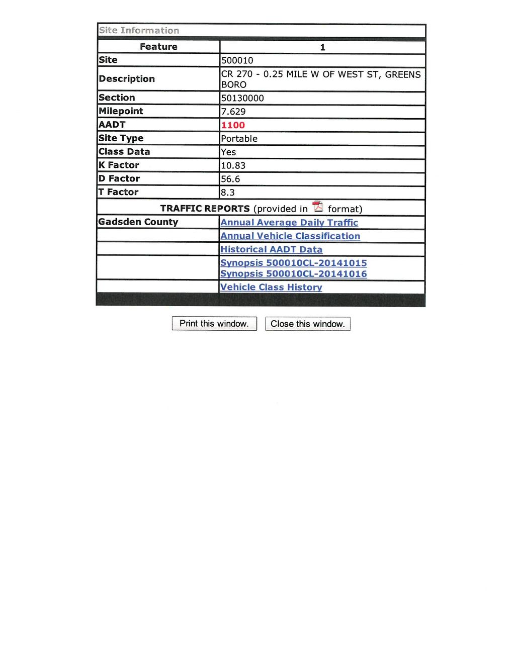
3 Planning Commission Agenda Report June 16, 2016 SSA Page 3 of 6 Concurrency Analysis: Potable Water and Sanitary Sewer: This project will be serviced by well and on-site septic systems. Solid Waste: Gadsden County does not maintain a solid waste facility. All waste is moved into Georgia from Gadsden County. Therefore, a solid waste concurrency evaluation is not conducted. Transportation (Attachment 3): The level of service for Sycamore Road (CR 270), as described in the Traffic Circulation Element, is a C. The closest road way traffic counts are on CR 270, Sycamore Road. The segment studied is from the Greensboro city limit to CR 269 and is currently at a level of service B. ITE Trip Generation, 8 th Edition, was used to determine the new trips that would be generated if the 1,500 square foot building is continued to be used as a site for the wrecker service. The Automobile Care Center (Code 942) was used as the use that closest resembles the wrecker service activity in the Trip Generation manual. It is important to note that the trips reported in this analysis are likely higher than the actual due to the nature of the business. The trip generation rates are as follows: Automobile Care Center (Code 942) 3.39 pm peak hour trips (of adjacent street traffic) per 1,000 square feet with a directional distribution of 50% entering and 50% exiting. This equates to 5.07 pm peak trips for this structure of approximately 1,500 square feet. Maximum volume of road segment: 17,300 AADT (LOS C); 850 peak hour/peak directional (LOS C) (1,500 square feet) 1.5 X 3.38 = 5.07 pm peak trips 5.07 X 56.6% (D factor) = 2.87 pm peak directional trips Existing pm peak directional (2014) = 67 trips Anticipated total pm peak directional = = trips Note: this analysis assumes pm peak hour. The ITE Trip Generation did not provide AADT values for this land use. Table 2: Transportation Analysis. Road Segment Existing Peak Hour Peak Dir. LOS (2014) Projected Peak Hour LOS Accepted LOS Max Volume* (peak hour) CR 270 Sycamore Rd. (site ) 67 trips B (6.36% max vol.) B (unchanged) LOS C *Adopted LOS based upon Policy of the Transportation Element.
4 Planning Commission Agenda Report June 16, 2016 SSA Page 4 of 6 Therefore, existing use of this site is not anticipated to negatively impact accepted level of services standards for Sycamore Road with an additional 5.07 pm peak hour trips. In addition, as defined by the Land Development Code, the proposed development of this site is a De Minimis impact. Section 2100 Definitions: De Minimis Impact is defined as: A proposed development that relates to a land use of such a low intensity as to have a minimal effect upon the Level of Service Standards (LOSS) adopted in the Gadsden County Comprehensive Plan. Such impact would not have more than one percent of the maximum volume at the adopted level of service (emphasis added) of the affected transportation facility as determined by the current trip counts, provided however, that an impact of a single family home on an existing lot of record will constitute a de minimis impact. The 1% of the maximum volume at the adopted level of service for this road segment is 8.5 peak hour/peak directional trips. This development would potentially generate 2.87 peak hour/peak directional trips. Public Schools: Not applicable. There is no residential density associated with this category. Public Parks: This project does not generate dwelling units, so a concurrency analysis as an impact of the development is not provided. Comprehensive Plan Objectives and Policies: The following policies guide the request of this amendment. Future Land Use Element: Policy 1.1.1: Gadsden County shall regulate the use of land through the adopted land use categories as follows. The Future Land Use Map shall be used to determine the location and extent of development within Gadsden County. K. Commercial - 1) Purpose and Intent The intent of this category is to provide areas for general commercial activities. 2) Designation Criteria Areas along collector or arterial roadways, as designated on the Functional Classification of Roadways Map in the Transportation Element. 3) Density 0.00 except for mobile home parks which shall be limited to a maximum of five units per acre. 4) Intensity The floor area ratio shall not exceed ) Impervious Surface Area No more than 0.75 lot coverage, except the centralized utilities uses are exempted from impervious surface requirements.
5 Planning Commission Agenda Report June 16, 2016 SSA Page 5 of 6 6) Allowable Uses All uses allowable in the Neighborhood Commercial category; museums; galleries; other civic activities; lodging establishments; private clubs; entertainment; wholesale sales; shopping centers; office complexes; light manufacturing uses that are restricted to in-plant assembly; mobile home parks, recreational vehicle parks. 7) Development Restrictions The storage of outdoor equipment must be screened from the public right-of-way. Junk yards or construction and debris landfills are prohibited in this category. Mobile home parks shall be on a centralized water and waste water system to receive a density of greater than one dwelling unit per acre. Policy : Any applicant for a Future Land Use Map amendment shall at minimum supply the following information to the County when requesting such Map amendment: A. Location and amount (in percentage of total parcel) of on-site jurisdictional wetlands. None. B. Availability and capacities of existing and proposed potable water and sanitary sewer utilities. Not applicable. Using a private well and on-site sewer. C. Proposed location of ingress and egress of development. As existing. D. Distance and location of nearest same land use category. See Table 1 above. E. Description of adjacent land use categories. See Table 1 above. F. In addition, for any land use category which supports residential development: 1) Existing and proposed school capacities (See Policy ). 2) Existing and proposed park space (See Policy 6.3.3). Not applicable. Objective 1.4: Protect existing neighborhoods. Policy 1.4.1: New non-residential development which is proposed contiguous to lands designated Rural Residential on the Future Land Use Map shall be of a scale and intensity appropriate to the existing residential development. Policy 1.4.2: Neighborhood character shall be preserved and promoted by working toward maintaining compatibility of surrounding land uses.
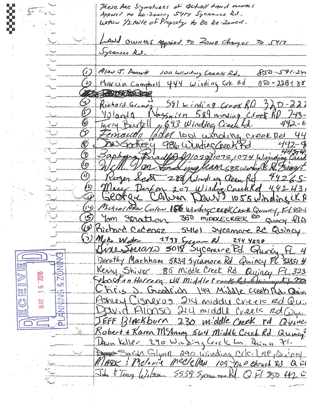
6 Planning Commission Agenda Report June 16, 2016 SSA Page 6 of 6 Policy 1.4.5: A compatibility analysis shall be submitted by the applicant for any proposed land use change contiguous to existing land designated Rural Residential on the Future Land Use Map. Compatibility shall mean a condition in which land uses or conditions can coexist in relative proximity to each other in a stable fashion over time such that no use or condition is unduly negatively impacted directly or indirectly by another use or condition. Not Supplied. Planning Department Findings: The site has historically been used commercially. Citizen s Bill of Rights: The applicants held a Citizen s Bill of Rights meeting on May 14, 2016 at the Greensboro Public Library. Staff member Willie Brown was in attendance. Fifteen or more citizens attended. A summary of the meeting has been provided by the applicant, and a petition in opposition submitted (see Attachment 4). The petition signatures were supplied by an attendee of the meeting. Planning Commission Options: 1. Recommend that the BOCC adopt the Future Land Use Map amendment as drafted or amended and submit to the Department of Economic Opportunity, as required. 2. Recommend that the BOCC does not adopt the Future Land Use Map amendment as drafted or amended. Staff Recommendation: Commission discretion. Attachments: 1. Future Land Use Map. 2. Applicant commentary on the application 3. Transportation Analysis documents 4. Citizen s Bill of Rights Summary Minutes & Petition 5. Letter from FDEP.
 SSA-2016-03 --------------------------------- Gadsden County Legend - Future Land Use categories AGRICULTURE 1 HEAVY")
7 Winding Creek Rd. CR 270 (Sycamore Rd.) Middle Creek Rd. Old Church Rd. Audie Clark Rd. Will White Rd Subject Property Goodson Rd Garner Rd CR 379 (Edwin Clark Rd) SSA Gadsden County Legend - Future Land Use categories AGRICULTURE 1 HEAVY INDUSTRIAL AGRICULTUER 2 LIGHT INDUSTRIAL HISTORICAL MINING DATE: May 24, 2016 SOURCE: Gadsden County Planning Dept. DISCLAIMER: This map is intended for planning purposes only. Gadsden County assumes no responsibility for any errors are inaccuracies shown within the map. AGRICULTURE 3 COMMERCIAL CONSERVATION RURAL RESIDENTIAL SILVICULTURE URBAN SERVICE AREA MUNICIPAL PUBLIC RECREATIONAL Miles
8 Attachment 2 - Applicant commentary
9
10 Attachment 3 - Transportation Analysis
11
12
13
14 Attachment 4 - CBOR summary and petitions
15
16
17
18
19
20 Attachment 5 - FDEP letter
21
22
23
GADSDEN COUNTY COMPREHENSIVE PLAN
 GADSDEN COUNTY COMPREHENSIVE PLAN 2015-2025 GADSDEN COUNTY BOARD OF COUNTY COMMISSIONERS Eric Hinson, District 1 Anthony O. Viegbesie, Phd., District 2 Gene Morgan, District 3 Brenda A. Holt, District
COMPREHENSIVE PLAN FUTURE LAND USE MAP AMENDMENT APPLICATION
 COUNTY STAFF DATA ONLY Date Received: Project No. CPA-20 - GADSDEN COUNTY DEPARTMENT OF PLANNING & COMMUNITY DEVELOPMENT 1-B East Jefferson Street, Post Office Box 1799, Quincy, FL 32353-1799 PLANNING
Marion County Board of County Commissioners
 Marion County Board of County Commissioners Date: 6/4/217 P&Z: 9/25/217 BCC Transmittal: 1/17/217 BCC Adopt: TBD Amendment No: 217-L6 Type of Application Large-Scale Comp Plan Amendment Request: Change
PUTNAM COUNTYCOMPREHENSIVE PLAN
 COMPREHENSIVE PLAN EXHIBIT AA COMPREHENSIVE PLAN A. Future Land Use Element Goals, Objectives, Policies This section proposed objectives and policies, which will assist Putnam County Commissioners and
Planning Department Oconee County, Georgia STAFF REPORT
 Planning Department Oconee County, Georgia STAFF REPORT REZONE CASE #: 7332 DATE: November 28, 2017 STAFF REPORT BY: Gabriel Quintas, Planner APPLICANT NAME: Smith Planning Group PROPERTY OWNER: John Hadden
Application to Amend the Bay County Zoning Map (Please type or print clearly)
") Application to Amend the Bay County Zoning Map (Please type or print clearly) File No.: Date Received: A) Applicant Information Owners Authorized name: agent: Mailing Mailing address: address: E-mail:
Application to Amend the Bay County Zoning Map (Please type or print clearly) File No.: Date Received: A) Applicant Information Owners Authorized name: agent: Mailing Mailing address: address: E-mail:
Class II, Type 11 Site Plan Conceptual/Preliminary Conceptual CITY: STATE: ZIP: TELEPHONE: ( ) 2. AUTHORIZED REPRESENTATIVE NAME: ADDRESS:
 2. AUTHORIZED REPRESENTATIVE NAME: ADDRESS:") GADSDEN COUNTY BUILDING & PLANNING & DEPARTMENT 1-B East Jefferson Street, Post Office Box 1799, Quincy, FL 32353-1799 Phone: (850) 875-8663 Fax: (850) 875-7280 E-mail: planning@gadsdencountyfl.gov Web
GADSDEN COUNTY BUILDING & PLANNING & DEPARTMENT 1-B East Jefferson Street, Post Office Box 1799, Quincy, FL 32353-1799 Phone: (850) 875-8663 Fax: (850) 875-7280 E-mail: planning@gadsdencountyfl.gov Web
FUTURE LAND USE. City of St. Augustine Comprehensive Plan EAR-Based Amendments
 FUTURE LAND USE City of St. Augustine Comprehensive Plan EAR-Based Amendments Future Land Use Element FLU Goal To create an environment within the City and adjacent areas in which its residents have the
Subchapter 5 Zoning Districts and Limitations
 Subchapter 5 Zoning Districts and Limitations 35.5.1 Rural Districts Sections: 35.5.1.1 Purpose. 35.5.1.2 Permitted Uses. 35.5.1.3 General Regulations. 35.5.1.1 Purpose. The purpose of a Rural District
INDIAN RIVER COUNTY, FLORIDA. The Honorable Members of the Planning and Zoning Commission DEPARTMENT HEAD CONCURRENCE
 Public Hearing Legislative INDIAN RIVER COUNTY, FLORIDA M E M O R A N D U M TO: The Honorable Members of the Planning and Zoning Commission DEPARTMENT HEAD CONCURRENCE Robert M. Keating, AICP; Community
ARTICLE 5.0 SCHEDULE OF REGULATIONS
 ARTICLE 5.0 SCHEDULE OF REGULATIONS Section 5.101 Table of Dimensional Standards by District. Dimensional Standards AG AG with sewer Districts Rural Residential Business Other SF SF with sewer R-1 R-1
AGENDA. a. Carol Crews Special Exception Hair Salon (Continued from February) b. James Barber Special Exception Horse
 b. James Barber Special Exception Horse") Baker County Land Planning Agency (LPA) Thursday, April 23, 2015 Baker County Administration Building 55 North Third Street Macclenny, FL 32063 (904) 259-3354 AGENDA 5:OO P.M. LDR Mining Workshop A. Draft
Baker County Land Planning Agency (LPA) Thursday, April 23, 2015 Baker County Administration Building 55 North Third Street Macclenny, FL 32063 (904) 259-3354 AGENDA 5:OO P.M. LDR Mining Workshop A. Draft
City of Panama City Zoning Regulations. 7 feet HOUSE
 R-1 Residential-1 Single family, detached residences Public and private schools (K-12) Public or noncommercial private recreation Accessory uses or structures such as, but not limited to: - swimming pools
Cobb County Community Development Agency Zoning Division 1150 Powder Springs St. Marietta, Georgia 30064
 Cobb County Community Development Agency Zoning Division 1150 Powder Springs St. Marietta, Georgia 30064 Case # Z-63 Public Hearing Dates: PC: 11-06-18 BOC: 11-20-18 SITE BACKGROUND Applicant: Loyd Development
Planned Residential Development ( PRD ) Application
 Application") FOR PLANNING USE ONLY Application # PRD Application Fee $ Receipt No. Filing Date Completeness Date Planned Residential Development ( PRD ) Application A. PROJECT INFORMATION 1. Project Name: 2. Address
FOR PLANNING USE ONLY Application # PRD Application Fee $ Receipt No. Filing Date Completeness Date Planned Residential Development ( PRD ) Application A. PROJECT INFORMATION 1. Project Name: 2. Address
CITY OF DURHAM DURHAM COUNTY NORTH CAROLINA. Zoning Map Change Report. RR Existing Zoning. Rural Rural Density Residential Site Characteristics
 CITY OF DURHAM DURHAM COUNTY NORTH CAROLINA Zoning Map Change Report Meeting Date: February 26, 2007 Reference Name Arrowhead () Jurisdiction County Proposed Zoning RR Existing Zoning RS-20 Request Proposed
KNOXVILLE/KNOX COUNTY METROPOLITAN PLANNING COMMISSION PLAN AMENDMENT/REZONING REPORT
 KNOXVILLE/KNOX COUNTY METROPOLITAN PLANNING COMMISSION PLAN AMENDMENT/REZONING REPORT FILE #: 4-G-12-RZ 4-C-12-SP AGENDA ITEM #: 27 AGENDA DATE: 5/10/2012 POSTPONEMENT(S): 4/12/12 APPLICANT: OWNER(S):
Interstate I-10/County Road 255 Madison County, Florida 32341
 Love s Truck Stop Red Onion Truck Stop Interstate I-10/County Road 255 Madison County, Florida 32341 Property Features 57.73 Acres Zoning: Mixed Use Tax ID: 261S101316002004, 261S121316002000 & 261S101316002003
City File ZM th Street North St. Petersburg, FL Central Avenue, Suite 1600 St. Petersburg, FL 33701
 Staff Report to the St. Petersburg Community Planning & Preservation Commission Prepared by the Planning & Development Services Department, Urban Planning and Historic Preservation Division For Public
Chapter 7 SITE DEVELOPMENT STANDARDS
 Chapter 7 SITE DEVELOPMENT STANDARDS CHAPTER 7 SITE DEVELOPMENT STANDARDS Section 701 Purpose and Intent The purpose of this Chapter is to establish minimum site requirements for the development and use
REZONING APPLICATION INSTRUCTIONS
 REZONING APPLICATION INSTRUCTIONS All required information, as stated on the Rezoning Application Checklist, must be included to qualify as a complete application. Upon receipt, staff will review the application
REPORT OF THE PLANNING AND DEVELOPMENT DEPARTMENT FOR APPLICATION FOR REZONING ORDINANCE TO PLANNED UNIT DEVELOPMENT SEPTEMBER 22, 2016
 BEL REPORT OF THE PLANNING AND DEVELOPMENT DEPARTMENT FOR APPLICATION FOR REZONING ORDINANCE 2016-576 TO PLANNED UNIT DEVELOPMENT SEPTEMBER 22, 2016 The Planning and Development Department hereby forwards
CITY OF WINTER SPRINGS
 CITY OF WINTER SPRINGS COMMUNITY DEVELOPMENT DEPARTMENT 1126 STATE ROAD 434 WINTER SPRINGS, FL 32708 407-327-5967 FAX:407-327-6695 APPLICATION FOR COMPREHENSIVE PLAN AMENDMENT APPLICANT: MAILING ADDRESS:
Mohave County General Plan
 63 64 65 66 67 68 69 70 71 The Land Use Diagram is not the County's zoning map. 13 It is a guide to future land use patterns. Zoning and area plan designations may be more restrictive than the land use
Marion County Board of County Commissioners
 Marion County Board of County Commissioners Date: 12/2/2015 P&Z: 11/30/2015 BCC: 12/16/2015 Amendment No: 2015-S05 Type of Application Small Scale FLUMS Amendment Request Rural Land to Rural Activity Center
CITY OF TARPON SPRINGS Staff Report May 16, 2017
 CITY OF TARPON SPRINGS Staff Report May 16, 2017 TO: FROM: HEARING DATES: SUBJECT: MAYOR & BOARD OF COMMISSIONERS PLANNING & ZONING DEPARTMENT MAY 15, 2017 (PLANNING & ZONING BOARD) JUNE 6, 2017 (BOC 1
CITY OF PALM BEACH GARDENS CITY COUNCIL Agenda Cover Memorandum Meeting Date: November 1, 2018 Ordinance 24, 2018 / *Ordinance 25, 2018
 CITY OF PALM BEACH GARDENS CITY COUNCIL Agenda Cover Memorandum Meeting Date: November 1, 2018 Subject/Agenda Item: 11940 U.S. Highway One Small-Scale Comprehensive Plan Future Land Use Map Amendment and
CITY OF HENDERSON TABLE OF CONTENTS. Section 101: Purpose... 1 Section 102: Authority... 1 GENERAL REGULATIONS APPLIED TO ALL DISTRICTS
 TABLE OF CONTENTS ARTICLE 100: PURPOSE AND AUTHORITY Section 101: Purpose... 1 Section 102: Authority... 1 ARTICLE 200: GENERAL REGULATIONS APPLIED TO ALL DISTRICTS Section 201: Jurisdiction and Zoning
Glades County Staff Report and Recommendation REZONING
 Glades County Staff Report and Recommendation REZONING CASE NUMBER: RZ15-01 DATE: October 2, 2015 CASE TYPE: Application for Rezoning REQUEST: J.J. Wiggins Memorial Trust is requesting a rezoning of 22.1±
ARTICLE V AGRICULTURAL PRESERVATION AND RURAL RESIDENTIAL DISTRICT
 ARTICLE V AP AGRICULTURAL PRESERVATION AND RURAL RESIDENTIAL DISTRICT Section 500. PURPOSE It is the purpose of the AP, Agricultural Preservation and Rural Residential District, to foster the preservation
STAFF REPORT. Permit Number: Gonzalez. Kitsap County Board of Commissioners; Kitsap County Planning Commission
 STAFF REPORT Permit Number: 15 00657 Gonzalez DATE: March 2, 2016 TO: FROM: Kitsap County Board of Commissioners; Kitsap County Planning Commission Katrina Knutson, AICP, Senior Planner, DCD and Jeff Arango,
Conditional Use Permit case no. CU 14-06: Bristol Village Partners, LLC
 PLANNING AND ZONING COMMISSION STAFF REPORT August 7, 2014 Conditional Use Permit case no. CU 14-06: Bristol Village Partners, LLC CASE DESCRIPTION: LOCATION: LEGAL DESCRIPTION: EXISTING LAND USE: ZONING:
Initial Subdivision Applications Shall Include the Following:
 Initial Subdivision Applications Shall Include the Following: 1) Subdivision Application Form: completely filled out (12 copies) 2) Plat: The Plat must adhere to the requirements set forth in the Town
Town of Cary, North Carolina Rezoning Staff Report 14-REZ-20 Habitat for Humanity Evans Road Town Council Meeting October 16, 2014
 Town of Cary, North Carolina Rezoning Staff Report 14-REZ-20 Habitat for Humanity Evans Road Town Council Meeting October 16, 2014 REQUEST To amend the Town of Cary Official Zoning Map by rezoning 0.53
E. Maintain and preserve the character of the community and residential neighborhoods; and
 822 HOME OCCUPATIONS 822.01 PURPOSE Section 822 is adopted to: A. Encourage economic development in the County by promoting home occupations; B. Reduce vehicle miles traveled by providing opportunities
1. Future Land Use FLU6.6.8 Land uses within the Rural Service Area portion of the Wekiva Study Area shall be limited to very low and low intensity
 1. Future Land Use FLU6.6.8 Land uses within the Rural Service Area portion of the Wekiva Study Area shall be limited to very low and low intensity uses to the greatest extent possible. Existing land uses
Medical Marijuana Special Exception Use Information
 Medical Marijuana Special Exception Use Information The Special Exception Use information below is a modified version of the Unified Development Code. It clarifies the current section 5:104 Special Exceptions
Site Plan Application
 Site Plan Application City of St. Pete Beach Community Development Department 155 Corey Avenue St. Pete Beach, Florida 33706 (727) 367-2735 www.stpetebeach.org Case Number: PROPERTY OWNER: Name: Address:
- A G E N D A - PLEASE TURN ALL CELL PHONES AND PAGERS OFF BEFORE ENTERING CHAMBERS PUBLIC HEARING APPLICATIONS (INDIVIDUAL CONSIDERATION)
") - A G E N D A - H E A R I N G O F F I C E R Manatee County Government Administrative Center 1112 Manatee Avenue West 1 st Floor Chambers Bradenton, Florida 34205 July 21, 2014 3:00 pm PLEDGE OF ALLEGIANCE
- A G E N D A - H E A R I N G O F F I C E R Manatee County Government Administrative Center 1112 Manatee Avenue West 1 st Floor Chambers Bradenton, Florida 34205 July 21, 2014 3:00 pm PLEDGE OF ALLEGIANCE
Department of Planning Services Division of Planning SARAH E. KEIFER, AICP Phone: 302/ Director of Planning Services FAX: 302/
 Kent County Department of Planning Services Division of Planning SARAH E. KEIFER, AICP Phone: 302/744-2471 Director of Planning Services FAX: 302/736-2128 KRISTOPHER S. CONNELLY, AICP Assistant Director
WESTMINSTER PARK SUBDIVISION
 WESTMINSTER PARK SUBDIVISION Engineering Comments: FINAL PLAT COMMENTS (should be addressed prior to submitting the FINAL PLAT for review and/or signature by the City Engineer): A. Provide all of the required
April 19, Planning and Land Development Regulation Commission (PLDRC)
") Page 1 of 15 GROWTH AND RESOURCE MANAGEMENT DEPARTMENT PLANNING AND DEVELOPMENT SERVICES DIVISION 123 W. Indiana Avenue, DeLand, FL 32720 (386) 736-5959 PLDRC HEARING: CASE NO: SUBJECT: LOCATION: APPLICANT:
Page 1 of 15 GROWTH AND RESOURCE MANAGEMENT DEPARTMENT PLANNING AND DEVELOPMENT SERVICES DIVISION 123 W. Indiana Avenue, DeLand, FL 32720 (386) 736-5959 PLDRC HEARING: CASE NO: SUBJECT: LOCATION: APPLICANT:
Nassau County Department of Planning & Economic Opportunity Nassau Place Yulee, Florida 32097
 Nassau County Department of Planning & Economic Opportunity 96161 Nassau Place Yulee, Florida 32097 APPLICATION AND INSTRUCTIONS FOR FUTURE LAND USE MAP AMENDMENT (TEN (10) ACRES OR MORE) NOTICE: Florida
ARTICLE 6 RU, RURAL ZONING DISTRICTS. RU (Rural) Zoning Districts are established to achieve the following purposes:
 Zoning Districts are established to achieve the following purposes:") ARTICLE 6 RU, RURAL ZONING DISTRICTS 601 Purpose RU (Rural) Zoning Districts are established to achieve the following purposes: 601.01 To preserve the character of areas designated as "Rural" in the Cochise
ARTICLE 6 RU, RURAL ZONING DISTRICTS 601 Purpose RU (Rural) Zoning Districts are established to achieve the following purposes: 601.01 To preserve the character of areas designated as "Rural" in the Cochise
STAFF SUMMARY OF S18-04 SPECIAL USE PERMIT APPLICATION
 APPLICATION SUMMARY Case Number: S18-04 Request: STAFF SUMMARY OF S18-04 SPECIAL USE PERMIT APPLICATION Special use permit in order to develop an indoor/outdoor recreation facility Applicant: Property
Instructions and Application Procedures Plan Amendments
 Glades County Instructions and Application Procedures Plan Amendments Small Scale Plan Amendments are changes to the Future Land Use Map designation of properties 10 acres or less in size, or, in some
ZRTD , Glenn Drive. M. Tyler Klein, AICP, Project Manager, Planning and Zoning John Merrithew, Acting Director, Planning and Zoning
 DEPARTMENT OF PLANNING Date of Hearing: AND ZONING STAFF REPORT # 4 BOARD OF SUPERVISORS PUBLIC HEARING SUBJECT: ELECTION DISTRICT: ZRTD-2014-0003, 22675 Glenn Drive Broad Run CRITICAL ACTION DATE: September
Planning Department Oconee County, Georgia
 Planning Department Oconee County, Georgia STAFF REPORT REZONE CASE #: 6985 DATE: October 31, 2016 STAFF REPORT BY: Andrew C. Stern, Planner APPLICANT NAME: Williams & Associates, Land Planners PC PROPERTY
STAFF REPORT. Permit Number: Lee. Kitsap County Board of Commissioners; Kitsap County Planning Commission
 STAFF REPORT Permit Number: 15 00689 Lee DATE: March 2, 2016 TO: FROM: Kitsap County Board of Commissioners; Kitsap County Planning Commission Katrina Knutson, AICP, Senior Planner, DCD and Jeff Arango,
CHAPTER 5 DEVELOPMENT STANDARDS.
 SECTION 5000. GENERAL STANDARDS. CHAPTER 5 DEVELOPMENT STANDARDS. Subsection 5001. Establishment of Performance Standards. Gadsden County is committed to the protection of the general health, safety and
Planning Commission Application Summary
 Planning Commission Application Summary Project Name: Creekside Estates Zone Change and Land Use Amendment Address: 571 West 11400 South Current Zoning: RA1 Hearing Date: July 14, 2016 Summary of Request
CHAPTER Committee Substitute for Committee Substitute for Senate Bill No. 2188
 CHAPTER 2004-372 Committee Substitute for Committee Substitute for Senate Bill No. 2188 An act relating to land development; amending s. 197.502, F.S.; providing for the issuance of an escheatment tax
AGENDA ITEM SUMMARY GLADES COUNTY BOARD OF COUNTY COMMISSIONERS
 AGENDA ITEM SUMMARY GLADES COUNTY BOARD OF COUNTY COMMISSIONERS SUBJECT: Case Number COMP17-01, Legend Moto LLC This is a Legislative Hearing. DEPARTMENT REQUEST: The Community Development Department requests
ZONING AMENDMENT & SUBDIVISION STAFF REPORT Date: July 9, 2015
 ZONING AMENDMENT & SUBDIVISION STAFF REPORT Date: July 9, 2015 APPLICANT NAME 2513 Dauphin Street, Inc. SUBDIVISION NAME Audubon Place Extension No. 3, Resubdivision of Lots 1-5 LOCATION 2513 Dauphin Street
Marion County Board of County Commissioners
 Marion County Board of County Commissioners Date: 12/29/2015 P&Z: 12/28/2015 BCC: 1/12/2016 Item Number 160113Z Type of Application Rezoning Request From: A-1 (General Agriculture) To: PUD (Planned Unit
Metropolitan Planning Commission. DATE: April 5, 2016
 TO: FROM: Metropolitan Planning Commission MPC Staff DATE: April 5, 2016 SUBJECT: Petition of Nine Line Inc. Robert McCorkle, Agent PIN: 2-1034-01-002 380.5 Acres Aldermanic District: 5 (Shabazz) County
PLANNING COMMISSION STAFF REPORT
 PLANNING COMMISSION STAFF REPORT MEETING DATE: 19 January 2017 APPLICANT: South Salt Lake City PROJECT NUMBER: T-17-002 REQUEST: APPLICANT: PREPARED BY: Recommendation to the South Salt Lake City Council
COMMUNITY DEVELOPMENT. Staff Report. Site Plan Review. SP June 19, 2018
 COMMUNITY DEVELOPMENT 333 Broadalbin Street SW, PO Box 490, Albany, Oregon 97321-0144 BUILDING 541-917-7553 PLANNING 541-917-7550 Staff Report Site Plan Review SP-18-18 June 19, 2018 Summary On May 1,
Expiration of Transportation Certificate of Concurrency for Application for Minor or Major Development; Approval
 Page 1 of 12 CHAPTER 3. CONCURRENCY 3.00.00. GENERALLY 3.00.01. Purpose and Intent The purpose of this chapter is to describe the requirements and procedures necessary to implement the concurrency provisions
Individual Well Individual Septic. Community Well 19. What is the proposed method of sewage disposal? Public. None
 Please Answer the Following Questions: (attach sheet if needed). What type of facility is being proposed? Campground Recreational Vehicle (RV) Park Both 2. What is the total acreage of the proposed facility?
SPECIAL USE (ALCOHOLIC BEVERAGE PERMIT) (WAIVER REQUIRED)
 (WAIVER REQUIRED)") SPECIAL USE (ALCOHOLIC BEVERAGE PERMIT) (WAIVER REQUIRED) IMPORTANT INSTRUCTIONS TO ALL APPLICANTS: You must schedule an appointment to submit this application. To request an appointment please call 813-272-5600.
SPECIAL USE (ALCOHOLIC BEVERAGE PERMIT) (WAIVER REQUIRED) IMPORTANT INSTRUCTIONS TO ALL APPLICANTS: You must schedule an appointment to submit this application. To request an appointment please call 813-272-5600.
PLANNING COMMISSION REPORT Regular Agenda Public Hearing Item
 PC Staff Report 11/12/12 Item No. 2B- 1 PLANNING COMMISSION REPORT Regular Agenda Public Hearing Item ITEM NO. 2B: A TO GPI; 110 ACRES; E OF K-10 & N OF W 6 TH ST (MKM) : Consider a request to rezone approximately
Plat/Site Plan Application
 Instructions Plat/Site Plan Application For your application to be officially accepted for processing, you must complete this application in full. The owner/agent certification must be signed and notarized
Staff Report to the North Ogden City Council
 Staff Report to the North Ogden City Council SYNOPSIS / APPLICATION INFORMATION Application Request: Public hearing for consideration and action on a legislative application to amend the North Ogden General
REPORT OF THE PLANNING AND DEVELOPMENT DEPARTMENT FOR APPLICATION FOR REZONING ORDINANCE TO PLANNED UNIT DEVELOPMENT MAY 18, 2017
 BEL REPORT OF THE PLANNING AND DEVELOPMENT DEPARTMENT FOR APPLICATION FOR REZONING ORDINANCE 2016-805 TO PLANNED UNIT DEVELOPMENT MAY 18, 2017 The Planning and Development Department hereby forwards to
Understanding the Conditional Use Process
 Understanding the Conditional Use Process The purpose of this document is to explain the process of applying for and obtaining a conditional use permit in the rural unincorporated towns of Dane County.
a. It is the intent of these regulations to encourage the preservation of natural resources and facilitate orderly growth in the County.
 Part V Transfer of Development Rights Section 246. 1. Intent a. It is the intent of these regulations to encourage the preservation of natural resources and facilitate orderly growth in the County. b.
Planning and Development Services Department
 Planning and Development Services Department M E M O R A N D U M TO: Planning and Zoning Commission THROUGH: Mark Satterlee, AICP, Planning & Development Services Director Leslie Olson, AICP, Planning
City of Peachtree City. Annexation Review Process
 City of Peachtree City Annexation Review Process Page 1 Annexation Review Process Step One: Initial annexation information The following information is to be completed by the property owner and/ or their
RECOMMENDATION REPORT
 SARPY COUNTY PLANNING & BUILDING DEPARTMENT RECOMMENDATION REPORT CHANGE OF ZONE (CZ 18-005) PRELIMINARY PLAT (PP 18-007) FINAL PLAT (FP 18-008) SCHOLTING ESTATES APPLICANT: DIANE SCHOLTING PLANNING COMMISSION
2016 FUTURE LAND USE ATLAS AMENDMENT APPLICATION. Palm Beach County Planning Division 2300 North Jog Road, WPB, FL 33411, (561)
") I. Amendment Data 2016 FUTURE LAND USE ATLAS AMENDMENT APPLICATION Palm Beach County Planning Division 2300 North Jog Road, WPB, FL 33411, (561) 233-5300 Round 18-B Intake Date August 4, 2017 Application
I. Amendment Data 2016 FUTURE LAND USE ATLAS AMENDMENT APPLICATION Palm Beach County Planning Division 2300 North Jog Road, WPB, FL 33411, (561) 233-5300 Round 18-B Intake Date August 4, 2017 Application
Town of Truckee. Contents. Article I - Development Code Enactment and Applicability. Chapter Purpose and Effect of Development Code...
 Town of Truckee TITLE 18 - DEVELOPMENT CODE Article I - Development Code Enactment and Applicability Chapter 18.01 - Purpose and Effect of Development Code... I-3 18.01.010 - Title... I-3 18.01.020 - Purposes
PALM BEACH COUNTY PLANNING, ZONING AND BUILDING DEPARTMENT ZONING DIVISION
 PALM BEACH COUNTY PLANNING, ZONING AND BUILDING DEPARTMENT ZONING DIVISION Application No.: Z-2016-00663 Application Name: Autism School Control No.: 2014-00133 Applicant: Dayna2, LLC Owners: Dayna2, LLC
COUNTY SUBDIVISION. Attachments: (1) Staff Analysis (2) Subdivision Maps (3) Related Documents including the Disclosure Statement
 Staff Analysis (2) Subdivision Maps (3) Related Documents including the Disclosure Statement") COUNTY SUBDIVISION DOÑA ANA COUNTY PLANNING AND ZONING COMMISSION Doña Ana County Government Center 845 N. Motel Blvd. Las Cruces, New Mexico 88007 Office: (575) 647-7250 MEETING DATE: August 25, 2011
COUNTY SUBDIVISION DOÑA ANA COUNTY PLANNING AND ZONING COMMISSION Doña Ana County Government Center 845 N. Motel Blvd. Las Cruces, New Mexico 88007 Office: (575) 647-7250 MEETING DATE: August 25, 2011
Burlington Unincorporated Community Plan
 Burlington Unincorporated Community Plan June 30, 2010 Meeting Page 1 of 24 Table of Contents (Page numbers to be inserted) I. Background a. Location and Community Description b. Planning of Unincorporated
Amendments to Chapter proposed by the Assembly Title 21 Committee
 Amendments to Chapter 21.04 proposed by the Assembly Title 21 Committee All page numbers refer to the S version. PZC recommended additions are underlined. PZC recommended deletions are in [BRACKETS AND
8. Building Status. 9. Current Use
 To be Completed by Staff Application No. Date Received: Received by: APPLICATION FOR PLANNED DEVELOPMENT Please submit electronically a completed application including required submittals to the Planning
MEMORANDUM. Douglas Hutchens, Interim City Manag~ August 4, 2016 / Greg Rice, Director of Planning & Development
 Agenda Item: Meeting Date: PH-1 8/18/16 TO: THROUGH: DATE: FROM: SUBJECT: PRESENTER: RECOMMENDATION: BUDGET IMP ACT: PAST ACTION: NEXT ACTION: ATTACHMENTS: BACKGROUND: City Commission MEMORANDUM Douglas
French, Bruce. The applicant is requesting a zone change from Suburban to Rural Service Center.
 BONNER COUNTY PLANNING DEPARTMENT PLANNING AND ZONING COMMISSION STAFF REPORT FOR FEBRUARY 2, 2017 Project Name: French, Bruce File Number,Type: ZC358-16, Zone Change Request: The applicant is requesting
RM18 RS9 RM12 RS9 !( S DOCKET #: W3120 PROPOSED ZONING: GB-L EXISTING ZONING: HB-S. PETITIONER: Bank of North Carolina for property owned by Same
 DELANE DR DOCKET #: W3120 RM18 BARRY ST PROPOSED ZONING: GB-L RS9 EXISTING ZONING: HB-S IP OLD GREENSBORO RD WALES ST DENVER ST GEORGE BIG REDD CT LOUISE WILSON LN RM12!(DS MOSES LUCAS CT 585' 627' HB-S
Nassau County Single Land Split Application
 NASSAU COUNTY DEPARTMENT OF PLANNING AND ECONOMIC OPPORTUNITY FLORIDA Nassau County Single Land Split Application Taco E. Pope, AICP, Director 96161 Nassau Place Yulee, Florida 32097 (904) 530-6300 APPLICATION
THE CITY OF RAYMORE, MISSOURI Single-Family Residential Zoning Districts
 THE CITY OF RAYMORE, MISSOURI Single-Family Residential Zoning Districts REGULATIONS COMMON TO ALL DISTRICTS: Uses permitted in each district include detached single-family dwellings, manufactured homes
Plans shall be drawn at a readable scale, signed, and sealed by a Florida Registered Engineer. The application package shall include:
 CHAPTER 400. SECTION 403. PERMIT TYPES AND APPLICATIONS SITE DEVELOPMENT 403.3. Preliminary Site Plans (PSP) A. Intent and Purpose PSPs are used to identify existing site conditions and demonstrate general
Article 6: Planned Unit Developments
 LUDC 2013 GARFIELD COUNTY, COLORADO Article 6: Planned Unit Developments ARTICLE 6 PLANNED UNIT DEVELOPMENTS TABLE OF CONTENTS DIVISION 1. GENERAL.... 1 6-101. GENERAL PROVISIONS.... 1 A. Purpose....
MUNICIPAL SERVICE BENEFIT UNIT (MSBU) CREATION AND ADMINISTRATION POLICY 16-01
 CREATION AND ADMINISTRATION POLICY 16-01") MUNICIPAL SERVICE BENEFIT UNIT (MSBU) CREATION AND ADMINISTRATION POLICY 16-01 PURPOSE: POLICY: The purpose of this policy is to provide an orderly and efficient method for utilizing the statutory authority
MUNICIPAL SERVICE BENEFIT UNIT (MSBU) CREATION AND ADMINISTRATION POLICY 16-01 PURPOSE: POLICY: The purpose of this policy is to provide an orderly and efficient method for utilizing the statutory authority
Draft Hendersonville Zoning Ordinance SUMMARY
 Draft Hendersonville Zoning Ordinance SUMMARY Section 1. Title, Purpose and Applicability Probably the most meaningful part of this section is Section 1.2. This states the preface and intent of the ordinance.
CHAPTER 3 REGULATIONS INSIDE THE COASTAL ZONE
 CHAPTER 3 REGULATIONS INSIDE THE COASTAL ZONE Organization. Chapter 3 contains the regulations which apply exclusively within the California Coastal Zone in Humboldt County and is organized as follows:
CITY OF SPRINGDALE, OHIO SPRINGDALE BUILDING DEPARTMENT SPRINGFIELD PIKE SPRINGDALE, OHIO TELEPHONE: (513)
") CITY OF SPRINGDALE, OHIO SPRINGDALE BUILDING DEPARTMENT 11700 SPRINGFIELD PIKE SPRINGDALE, OHIO 45246 TELEPHONE: (513) 346-5730 SUBMISSION REQUIREMENTS AND INSTRUCTIONS FOR REVISIONS TO APPROVED DEVELOPMENT
CITY OF SPRINGDALE, OHIO SPRINGDALE BUILDING DEPARTMENT 11700 SPRINGFIELD PIKE SPRINGDALE, OHIO 45246 TELEPHONE: (513) 346-5730 SUBMISSION REQUIREMENTS AND INSTRUCTIONS FOR REVISIONS TO APPROVED DEVELOPMENT
SITE DEVELOPMENT PLAN REQUIREMENTS CHECKLIST
 SITE DEVELOPMENT PLAN REQUIREMENTS CHECKLIST Completed DRC Application for Review Required for Application Process DRC Processing Fee 1 Commercial $2,500.00 Fire Department Review Fee 150.00 Total $2,650.00
619. Planned Development District (PD)
") 619. Planned Development District (PD) Intent. The purpose of the Planned Development District (sometimes hereinafter referred to as PD) is to provide opportunities to create more desirable environments
619. Planned Development District (PD) Intent. The purpose of the Planned Development District (sometimes hereinafter referred to as PD) is to provide opportunities to create more desirable environments
Master Plan Review SILVER SPRING CBD. Approved and Adopted February Updated January 2013
 Master Plan Review SILVER SPRING CBD Approved and Adopted February 2000 BACKGROUND ZONING CODE REWRITE In 2007, the Montgomery County Council directed the Planning Department to undertake a comprehensive
City: State: City: State: Phone: ( ) Fax: ( ) Phone: ( ) Fax: ( ) Project Information
 Fax: ( ) Phone: ( ) Fax: ( ) Project Information") CITY OF ALTAMONTE SPRINGS CONCURRENCY AND MOBILITY MANAGEMENT APPLICATION This application must be completely filled out for the review to begin. A copy of the Concurrency Test Results will be mailed to
CITY OF ALTAMONTE SPRINGS CONCURRENCY AND MOBILITY MANAGEMENT APPLICATION This application must be completely filled out for the review to begin. A copy of the Concurrency Test Results will be mailed to
Draft Model Access Management Overlay Ordinance
 Draft Model Access Management Overlay Ordinance This model was developed using the City of Hutchinson and the Trunk Highway 7 corridor. The basic provisions of this model may be adopted by any jurisdiction
ARTICLE XVII SCHEDULE OF REGULATIONS
 ARTICLE XVII SCHEDULE OF REGULATIONS SECTION 1700. LIMITING HEIGHT, BULK, DENSITY, AND AREA BY DISTRICT TYPE Use Minimum Size Lot Per Unit Maximum Height of Structures Minimum Yard Setback (Per Lot in
CITY OF SPRINGDALE, OHIO SPRINGDALE BUILDING DEPARTMENT SPRINGFIELD PIKE SPRINGDALE, OHIO TELEPHONE: (513)
") CITY OF SPRINGDALE, OHIO SPRINGDALE BUILDING DEPARTMENT 11700 SPRINGFIELD PIKE SPRINGDALE, OHIO 45246 TELEPHONE: (513) 346-5730 SUBMISSION REQUIREMENTS AND INSTRUCTIONS FOR MINOR REVISIONS TO PUD/TRANSITION
CITY OF SPRINGDALE, OHIO SPRINGDALE BUILDING DEPARTMENT 11700 SPRINGFIELD PIKE SPRINGDALE, OHIO 45246 TELEPHONE: (513) 346-5730 SUBMISSION REQUIREMENTS AND INSTRUCTIONS FOR MINOR REVISIONS TO PUD/TRANSITION
RE: 6. GILL/GREEN COMPREHENSIVE PLAN AMENDMENT, REZONING AND PRELIMINARY PLAT
 commission memo DATE: Thursday - August 9, 2018 TO: Marion Planning & Zoning Commission FROM: David N. Hockett, AICP Principal Planner RE: 6. GILL/GREEN COMPREHENSIVE PLAN AMENDMENT, REZONING AND PRELIMINARY
Chapter 2. Zoning Districts
 CHAPTER II. LAND USE ZONING DISTRICTS 2.00.00. GENERALLY In order to ensure that all development is consistent with the goals and objectives of the comprehensive plan, it is necessary and proper to establish
DRAFT Subject to Modifications
 TREASURE COAST REGIONAL PLANNING COUNCIL M E M O R A N D U M DRAFT Subject to Modifications To: Council Members AGENDA ITEM 5L From: Date: Subject: Staff September 17, 2010 Council Meeting Local Government
ZONING AMENDMENT & SUBDIVISION STAFF REPORT Date: March 1, 2018
 #13 SUB-000406-2018 & ZON-000407-2018 ZONING AMENDMENT & SUBDIVISION STAFF REPORT Date: March 1, 2018 NAME SUBDIVISION NAME LOCATION Creekside @ Kooiman Dairy Creekside @ Kooiman Dairy Subdivision (South
(Y/N) _}Y/N) (Y/N) (Y/N) 11 within a zoning category without the requirement to obtain a
 _}Y/N) (Y/N) (Y/N) 11 within a zoning category without the requirement to obtain a") ID COUNCIL/COMMITTEE ACTION ADOPTED ADOPTED AS AMENDED ADOPTED W/O OBJECTION FAILED TO ADOPT WITHDRAWN OTHER (Y/N) _}Y/N) ~ (Y/N) (Y/N) (Y/N) 1 Council/Committee hearing bill': Roads, Bridges & Ports Policy
ID COUNCIL/COMMITTEE ACTION ADOPTED ADOPTED AS AMENDED ADOPTED W/O OBJECTION FAILED TO ADOPT WITHDRAWN OTHER (Y/N) _}Y/N) ~ (Y/N) (Y/N) (Y/N) 1 Council/Committee hearing bill': Roads, Bridges & Ports Policy