ORDINANCE NO URBAN CORRIDOR AMENDMENTS
|
|
|
- Bridget Gibbs
- 5 years ago
- Views:
Transcription
1 ORDINANCE NO URBAN CORRIDOR AMENDMENTS AN ORDINANCE OF THE BOARD OF COUNTY COMMISSIONERS OF MANATEE COUNTY, FLORIDA, REGARDING COMPREHENSIVE PLANNING, AMENDING MANATEE COUNTY ORDINANCE NO , AS AMENDED, THE MANATEE COUNTY COMPREHENSIVE PLAN; PROVIDING FOR PURPOSE AND INTENT; PROVIDING FINDINGS; AMENDING THE FUTURE LAND USE ELEMENT TO DESIGNATE THE GEOGRAPHIC EXTENT OF THE URBAN CORRIDORS WITHIN THE EXISTING URBAN SERVICE AREA ON APPLICABLE MAPS; PROVIDING FOR DEFINITIONS; SAID DEFINITIONS ARE AMENDED TO INCLUDE A DEFINITION OF URBAN CORRIDOR ENCOMPASSING PROPERTIES THAT ABUT SPECIFIED ROADWAYS AS DESIGNATED ON MAP M OF THE FUTURE LAND USE MAP SERIES WITHIN THE URBAN SERVICE AREA OF MANATEE COUNTY AS DESIGNATED ON EXISTING MAP K OF THE FUTURE LAND USE MAP SERIES; SAID ROADWAYS INCLUDE PORTIONS OF MANATEE AVENUE WEST, CORTEZ ROAD WEST/44 TH AVENUE EAST, 53 RD AVENUE WEST/ SR 70, TAMIAMI TRAIL (US 41)/14 TH STREET WEST (BUSINESS US 41), 15 TH STREET EAST AND 1 ST STREET; PROVIDING FOR THE FOLLOWING TEXT AMENDMENTS TO THE FUTURE LAND USE ELEMENT: AMENDING THE POTENTIAL FOR DEVELOPMENT IN TERMS OF EITHER INTENSITY OF USE OR DENSITY (RESIDENTIAL UNITS) FOR PROPERTIES WITHIN THE FOLLOWING FUTURE LAND USE CATEGORIES IF LOCATED WITHIN THE DESIGNATED URBAN CORRDIORS AND SUBJECT TO STANDARDS IN THE LAND DEVELOPMENT CODE FOR: RESIDENTIAL-6 (RES-6), RESIDENTIAL-9 (RES-9), RESIDENTIAL -12 (RES-12) RESIDENTIAL-16 (RES-16), RETAIL OFFICE RESIDENTIAL (ROR), INDUSTRIAL LIGHT (IL), INDUSTRIAL HEAVY (IH), MIXED USE (MU), FUTURE LAND USE CATEGORIES; AMENDING THE ALLOWABLE USES WITHIN THE RESIDENTIAL 6 (RES-6), RESIDENTIAL 9 (RES- 9), RESIDENTIAL 12 (RES-12) FUTURE LAND USE CATEGORIES WITHIN DESIGNATED URBAN CORRIDORS TO ALLOW HOTELS AS POTENTIAL USES, SUBJECT TO APPLICABLE COMMERCIAL LOCATIONAL CRITERIA; DELETING THE LIMITATIONS AS TO MAXIMUM SQUARE FOOTAGE FOR COMMERCIAL DEVELOPMENTALONG DESIGNATED URBAN CORRIDORS; AMENDING THE NET DENSITY RESTRICTIONS FOR SPECIFIED DEVELOPMENT ALONG DESIGNATED URBAN CORRIDORS; DELETING THE REQUIREMENT FOR SPECIAL APPROVAL FOR SPECIFIED DEVELOPMENT ALONG DESIGNATED URBAN CORRIDORS; AMENDING PROVISIONS OF THE COMPREHENSIVE PLAN TO PRESERVE INTERNAL CONSISTENCY; PROVIDING FOR SEVERABILITY AND PROVIDING FOR AN EFFECTIVE DATE. WHEREAS, Chapter 125, Florida Statutes empowers the Board of County Commissioners of the County of Manatee to prepare and enforce comprehensive plans for the development of the county; and,
2 ORDINANCE NO WHEREAS, The Community Planning Act (the Act ) is codified in the applicable portions of Chapter 163, Part II, Florida Statutes (2016) as amended, empowers and requires the County (a) to plan for the county s future development and growth, and (b) to adopt and amend comprehensive plans, or elements or portions thereof, to guide the future growth and development of the county; and, WHEREAS, Manatee County Ordinance No , as amended, was adopted pursuant to general law for the purpose of providing a framework for land use and development in the unincorporated area of Manatee County, and established the Manatee County Comprehensive Plan; and, WHEREAS, Application PA has been initiated by the County to amend the Comprehensive Plan, to delineate the extent of designated Urban Corridors within the existing Urban Service Area and includes amendments to the maps and the text of the Future Land Use Element as well as the definitions of the Comprehensive Plan; and, WHEREAS, Application LDCT has been initiated by the County as an amendment to the Land Development Code to provide, among other matters, design guidelines and standards applicable to properties within the Urban Corridors; and, WHEREAS, at a duly noticed public hearing, the Manatee County Planning Commission, as the County s Local Planning Agency for purposes of the Act, considered Application PA-16-01; and passed a motion to recommend transmittal of Plan Amendment to the Board of County Commissioners; and, WHEREAS, after due public notice, the Board of County Commissioners of Manatee County received and considered the recommendation of the Manatee County Planning Commission, and held a public hearing on June 21, 2016, to consider Plan Amendment and the transmittal of the proposed amendment to the State Land Planning Agency in accordance with the Act; and, WHEREAS, the State Land Planning Agency by letter dated July 30, 2016, identified no comments related to important State resources and facilities within the Department of Economic Opportunity s (DEO) authorized scope of review that would be adversely impacted by Plan Amendment 16-01, if adopted; and, WHEREAS, the Florida Department of Transportation by letter dated July 27, 2016 transmitted its review comments on Plan Amendment as to transportation resources and facilities of State importance; and, WHEREAS, the Southwest Florida Water Management District, by letter dated July 27, 2016 provided comments regarding flood protection, wetlands and other surface waters, and regional water supply; and, WHEREAS, the staff of the Tampa Bay Regional Planning Council prepared a report on Plan Amendment PA and had their report affirmed by the Tampa Bay Regional Planning Council at the meeting of August 8, 2016; and, 2
3 ORDINANCE NO WHEREAS, the report of the Tampa Bay Regional Planning Council (the TBRPC) identified no adverse effects on regional resources or facilities as identified in Future of the Region: A Strategic Regional Policy Plan for the Tampa Bay Region 2005 and no extra- jurisdictional impacts were identified that would be inconsistent with the comprehensive plan of any affected local government; and, WHEREAS, the Florida Fish and Wildlife Commission (FFWC) by letter dated July 13, 2016, identified no comments related to fish and wildlife or listed species and their habitat; and, WHEREAS, the Florida Department of Education by letter dated July 6, 2016, identified no potential to significantly adversely affect public educational facilities; and, WHEREAS, the Florida Department of Environmental Protection, by correspondence dated July 22, 2016, transmitted its review comments for Plan Amendment PA and determined no provision in the Plan Amendment, if adopted, would adversely impact important State resources, specifically air and water pollution, wetlands and other surface waters of the State, federal and State owned lands and interests in lands including state parks, greenways and trails, conservation easements, solid waste, and water and wastewater treatment; and, WHEREAS, pursuant to Section , Florida Statutes (2016), on September 1, 2016, the Board of County Commissioners held an adoption public hearing, with due public notice having been provided, to consider said proposed amendment to the Comprehensive Plan; and, WHEREAS, the Board of County Commissioners further considered all oral and written comments received during said public hearings, the recommendations of the Planning Commission, and the comments of the State Land Planning Agency and all applicable State or local review agencies; and, WHEREAS, in exercise of said authority, the Board of County Commissioners has determined that the adoption of Plan Amendment PA would be in the public interest; and, WHEREAS, the Board of County Commissioners, based upon the foregoing findings, has determined that the requirements for amending the Comprehensive Plan in Section C.2.3.3, Introduction of the Comprehensive Plan have been satisfied; and, WHEREAS, all applicable requirements of general law and local law have been followed, and the proceedings have been conducted pursuant to Chapter 163, Part II, Florida Statutes (2016), and the Plan Format and Administration Section of the Manatee County Comprehensive Plan. NOW, THEREFORE, BE IT ORDAINED by the Board of County Commissioners of Manatee County that: Section 1. Purpose and Intent: This Ordinance is enacted to carry out the purpose and intent of, and exercise the authority set out in the Act, and Chapter 125, Florida Statutes, as amended. Section 2. Findings: The recitals set forth in the Whereas clauses above are true and correct and are hereby adopted as findings by the Board for the adoption of this Ordinance. 3
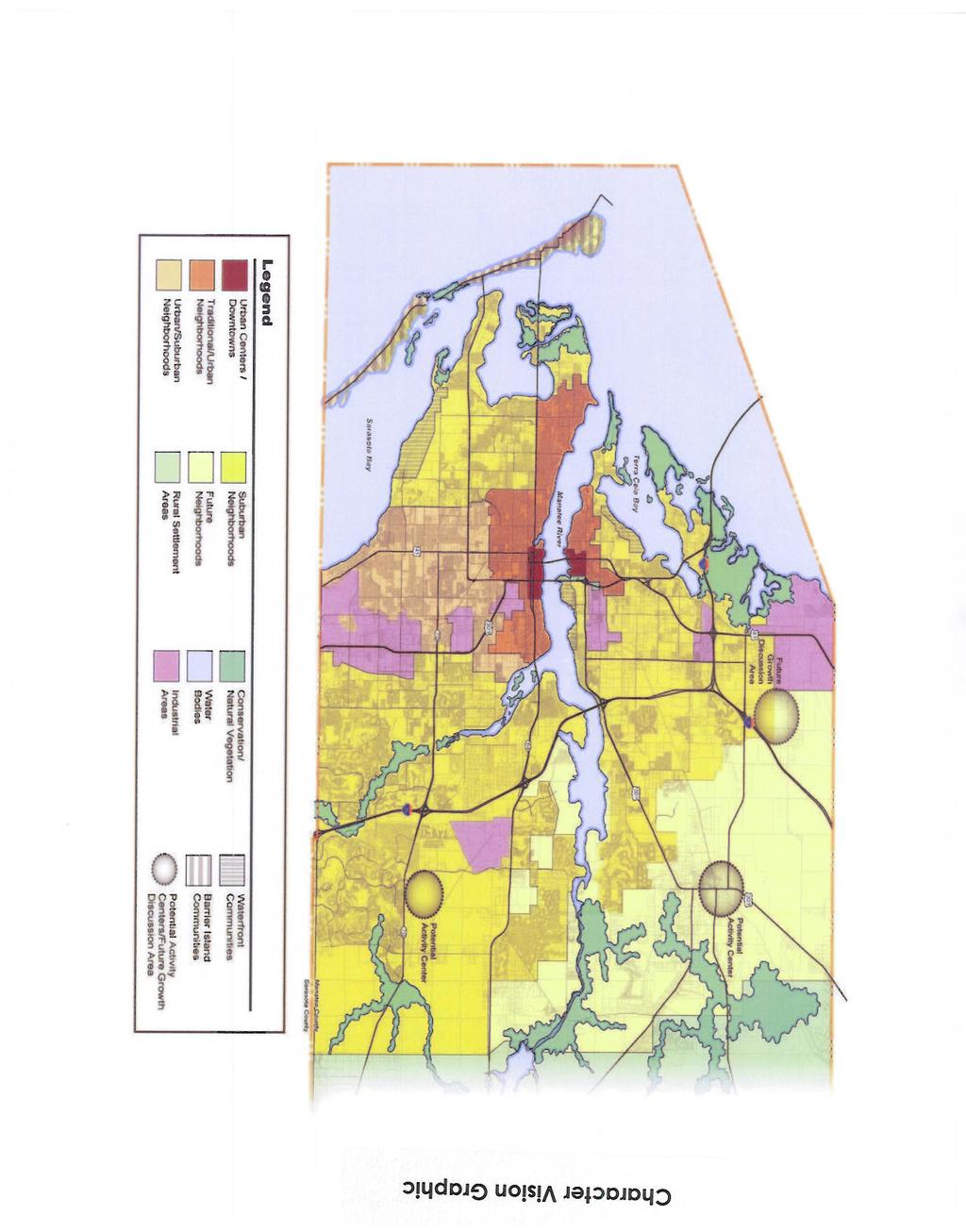
4 ORDINANCE NO Section 3. Map Amendment: The Manatee County Comprehensive Plan, Chapter entitled Future Land Use Maps and Future Land Use Maps Series is hereby amended in the following respects: the map legend is amended to re-label Map K-Urban Service Area, and to add a new Map L- Character Vision Graphic, and a new Map M-Urban Corridors, said Maps are described in Exhibit A, attached hereto and made a part hereof by reference. Section 4. Text Amendment to Definitions: The Manatee County Comprehensive Plan, Chapter entitled Definitions is hereby amended to add the new definitions and amend the definitions as described in Exhibit B attached hereto and made a part hereof by reference. Section 5. Text Amendment to Future Land Use Element: The Manatee County Comprehensive Plan, Future Land Use Element is hereby amended to add new or amended goals, objectives, and policies as described in Exhibit C attached hereto and made a part hereof by reference. Section 6. Text Amendment to Traffic Element: The Manatee County Comprehensive Plan, Traffic Element is hereby amended to add Policy providing for coordination with FDOT as described in Exhibit D attached hereto and made part hereof by reference. Section 7. Severability: If any section, sentence, clause or other provision of this Ordinance shall be held invalid or unconstitutional by a court of competent jurisdiction, such invalidity or unconstitutionality shall not be construed so as to render invalid or unconstitutional the remaining sections, sentences, clauses or provisions of this Ordinance. Section 8. Codification: Pursuant to Section (1), Fla. Stat., this ordinance is not required to be codified. Therefore, the Clerk shall not transmit the ordinance for codification. Section 9. Effective Date: The effective date of this Plan Amendment PA-16-01, if the amendment is not timely challenged, shall be 31 days after the State Land Planning Agency notifies Manatee County that the adopted plan amendment package for Plan Amendment PA is complete. If timely challenged, this amendment shall become effective on the date the State Land Planning Agency or the Administration Commission enters a final order determining this adopted Amendment PA to be in compliance. No development orders, development permits, or land uses dependent on this Plan Amendment PA may be issued or commenced before it has become effective. 4


5
6 Pages 1-29 Future Land Use Maps Additional Maps: G. Urban Infill and Redevelopment A. Wetlands Area B. Soils H. Urban Core C. Potable Wells I. Transportation Concurrency D. Regional Spoil Disposal Site Exception Area E. Coastal Storm Vulnerability J. Transportation Concurrency Area Overlay Exception Area F. Coastal Evacuation Area K. Urban Service Area Overlay L. Character Vision Graphic Excerpt Comprehensive Plan -Future Land Use Element M. Urban Corridors Page 20
7
8 Urban Corridors - Map M Palmetto Holmes Beach Municipality 21st AVE W 26TH AVE W Longboat Key 53rd Avenue Tamiami Trail 36TH ST W Cortez Road th Street East Bradenton Beach US US 301 Bradenton 1st Street Manatee Avenue Urban Service Area 34TH ST W 75TH ST Urban Corridors Map Author: Paul Hrebenach Creation Date: 4 / 2016 Map Document Name: Urban_Corridors.mxd Ú Miles UNIVERSITY PKWY Th is m ap was developed by the Manatee County Geographic Information Systems Division. It is provided for general reference and is not warranted in any way. Errors from non -coincidence of featu res from different sources m ay exist. The Manatee Count y BOCC sh all beheld harmless for inappropriate or unin tended u ses of the inform ation.
9 COMPREHENSIVE PLAN AMENDMENTS SPECIFIC TO URBAN CORRIDORS DEFINITIONS 1. Amendment to the following definitions: Floor Area Ratio - Gross nonresidential building floor area divided by gross land area related to such building area. Floor Area Ration (F.A.R.) is a measure of intensity for nonresidential development, and is calculated by determining the ratio of gross floor area of the sum of gross horizontal areas of all floors of an enclosed building measured from the exterior face of exterior walls, but not including interior parking, loading, or heights of less than six feet (in square feet), to the product of the total number of Gross Nonresidential Acres (as defined herein), or the total number of Gross Residential Acres plus the total number of Gross Nonresidential Acres in the case of Urban Corridors (as defined herein), contained in that lot or parcel times 43,560. Height of any floor within an existing or proposed building shall not be considered in determining F.A.R. of an existing building, nor considered in determining maximum allowable gross floor area by use of a maximum F.A.R. Where projects are proposed to contain more than one lot, Floor Area FAR shall be calculated on a project-wide basis (see also definition of "Intensity"). Gross Residential Density - The total number of residential dwelling units or equivalent residential units within a residential project, or within a residential parcel contained within a project, divided by gross residential acreage (as defined herein), or in the case of Urban Corridors (as defined herein), the total number of residential dwelling units or equivalent residential units contained within a project, divided by gross acreage of the entire site. Urban Corridor The area encompassing the properties that abut the following roadway corridors (see Map M) within Manatee County s Urban Service Area: Manatee Avenue West (from 75th Street West to 34th Street West) Cortez Road West/44th Avenue East (from 75th Street West to 15th Street East) 53rd Avenue West/SR-70 (from 75th Street West36th Avenue West to US 301) Tamiami Trail (US 41)/14th Street West (BUS 41) (from 26th Avenue West to University Parkway) 15th Street East (from US 301 to University Parkway) 1st Street (from 21th Avenue West to Cortez Road West) Excerpts Comprehensive Plan - Definitions Page 1
10 COMPREHENSIVE PLAN AMENDMENTS SPECIFIC TO URBAN CORRIDORS FUTURE LAND USE ELEMENT 1. Addition of Policy to Objective 2.1.3, Revitalization of the Urban Core Area: Policy Consider offering the following incentives for development along the Urban Corridors in the unincorporated part of the Urban Service Area: a. Expedited development review and permitting approvals through a process tailored for the designated areas b. Density/intensity bonuses c. Transit access provision d. Targeted infrastructure e. Public/private partnerships f. Parcel assembly support Implementation Mechanism: Revise the Land Development Code as necessary to implement this policy. 2. Amendment to Table 2-1 Summary of Future Land Use Classification System, Part I: Future Land Use Districts: [SEE NEXT PAGE] Excerpt Comprehensive Plan -Future Land Use Element Page 1
11 Future Land Use Category 7) Residential-6 DU/GA 8) Residential-9 DU/GA 9) Residential- 12 DU/GA Map Symbol Maximum Potential Density* (Gross Dwelling Units /Gross Acre) (DU/GA) TABLE 2-1 SUMMARY OF FUTURE LAND USE CLASSIFICATION SYSTEM PART I: FUTURE LAND USE DISTRICTS Page 1 of 5 Net(Dwelling Units/(Net Acre) RES Min. 5.0 in UIRA for residential projects that designate a in UIRA for residential projects minimum of 25% of the dwelling that designate a units as Affordable Housing minimum of 25% of the dwelling units as Affordable Housing RES max. along Urban Corridors 20 in UIRA for if a density bonus is approved residential projects Min 7.0 in UIRA for residential that designate a projects that designate a minimum of 25% of minimum of 25% of the dwelling the dwelling units as units as Affordable Housing Affordable Housing RES max. along Urban Corridors Min 10.0 in UIRA for residential projects that designate a minimum of 25% of the dwelling units as Affordable Housing in UIRA for residential projects that designate a minimum of 25% of the dwelling units as Affordable Housing Maximum Potential Intensity* (Floor Area Ratio (FAR) in UIRA 1.0 along designated Urban Corridors provided Goal 2.10 and associated policies are met in UIRA 1.0 along designated Urban Corridors provided Goal 2.10 and associated policies are met in UIRA 1.0 along designated Urban Corridors provided Goal 2.10 and associated policies are met. General Range of Potential Uses (See Policies for Additional Detail) Hotel uses may also be allowed within this designation but only along Urban Corridors. Same as for RES-1 Neo-traditional development is limited to Small (Neighborhood Retail Uses wholesale uses not allowed) Same as for RES-61. Neo-traditional development is limited to Small (Neighborhood Retail Uses wholesale uses not allowed) Same as for RES-61 Neo-traditional development is limited to Small (Neighborhood Retail Uses wholesale uses not allowed) Commercial Size Limitation Medium Medium Medium Excerpt Comprehensive Plan -Future Land Use Element Page 2
12 Future Land Use Category 10) Residential-16 DU/GA** 13) Retail/Office/ Residential Maximum Potential Density* (Gross Dwelling Units /Gross Acre) (DU/GA) Map Symbol RES max. along Urban Corridors Min 13.0 in UIRA for residential projects that designate a minimum of 25% of the dwelling units as Affordable Housing ROR max. along Urban Corridors (40 max. if a density bonus is approved) Min 7.0 in UIRA for residential projects that designate a minimum of 25% of the dwelling units as Affordable Housing Net(Dwelling Units/(Net Acre) in UIRA for residential projects that designate a minimum of 25% of the dwelling units as Affordable Housing in UIRA for residential projects that designate a min. of 25% of the dwelling units as Affordable Housing Maximum Potential Intensity* (Floor Area Ratio (FAR) in UIRA 1.0 along designated Urban Corridors provided Goal 2.10 and associated policies are met in UIRA 1.0 for Hotels 1.0 within designated Urban Corridors (2.0 if an FAR bonus is approved) 14) Industrial-Light IL in UIRA and within Urban Corridors 1.0 for Hotels 15) Industrial- Heavy IH in UIRA and within Urban Corridors General Range of Potential Uses (See Policies for Additional Detail) Same as for RES-91; also, Hotel/Motel Neo-traditional development is limited to Small (Neighborhood Retail Uses wholesale uses not allowed) Neighborhood Retail Uses, Community Serving Retail Uses, and Regional Retail Uses, Office Uses, Residential Uses, Hotel/Motel, Recreational Facilities Office, Light Industry, Research/Corporate Parks, Warehouse/Distribution, Intensive Commercial Uses, Neighborhood Retail Uses, Hotel/Motel, Selected Single-Family, Residential Uses. Light Industry, Heavy Industry, Ports, Intensive Commercial Uses, Neighborhood Retail Uses. Phosphate mining is not an allowable use. 16) Urban Industrial IU Light Industry, Heavy Industry, Warehouse/ Distribution, Neighborhood Retail Uses Commercial Size Limitation Medium (see Policy for urban corridors) Large (see Policy for urban corridors) Small Small Small Excerpt Comprehensive Plan -Future Land Use Element Page 3
13 Maximum Potential Density* (Gross Dwelling Units /Gross Acre) (DU/GA) Future Land Use Category Map Symbol 17) Mixed Use MU max. along Urban Corridors (40 max,. if a density bonus is approved) Min 7.0 in UIRA for residential projects that designate a minimum of 25% of the dwelling units as Affordable Housing, Net(Dwelling Units/(Net Acre) in UIRA for residential projects that designate a minimum of 25% of the dwelling units as Affordable Housing Maximum Potential Intensity* (Floor Area Ratio (FAR) 1.0 (2.0 within Urban Corridors if an FAR bonus is approved) 2.0 in UIRA General Range of Potential Uses (See Policies for Additional Detail) Neighborhood Retail Uses, Community Serving Retail Uses and Regional Retail, Office, Light Industrial, Research/Corporate Parks, Warehouse/ Distribution, Residential Uses, Hotel/Motel Commercial Size Limitation Large (see Policy for urban corridors) Notes: * Refer to Policy and to the more detailed description under each Future Land Use Category for limitations on the use of/or reliance on the information contained in this summary table. Density Bonus and FAR Bonus are defined and described in further detail in the Land Development Code. Excerpt Comprehensive Plan -Future Land Use Element Page 4
14 3. Amendment to Policy , RES-3: Policy Range of Potential Density/Intensity: - Maximum net residential density: - 6 dwelling units per acre - 9 dwelling units per acre within the UIRA for residential projects that designate a minimum of 25% of the dwelling units as Affordable Housing. - Maximum net densities shall not apply to projects within designated Urban Corridors. - (except within the WO or CHHA Overlay Districts, pursuant to Policies and ) - Maximum floor area ratio: (0.35 for mini-warehouse uses only) inside the UIRA and within designated Urban Corridors. - Maximum Square Footage for Neighborhood Retail Uses: Medium (150,000 sf) 4. Amendment to Policy (RES-3): Policy Other Information: a) All mixed and multiple-use projects require special approval, as defined herein, and as further defined in any land development regulations developed pursuant to , F.S. b) All projects for which gross density exceeds 2.0 dwelling units per acre, or in which any net residential density exceeds 3 dwelling units per acre, shall require special approval. c) Any nonresidential project exceeding 30,000 square feet of gross building area shall require special approval. d) The Special Approval requirements listed above (a through c) shall not apply to development along the designated Urban Corridors. 5. Amendment to Policy (RES-6): Policy Range of Potential Uses (see Policies , ): Suburban or urban residential uses, neighborhood retail uses, short-term agricultural Excerpt Comprehensive Plan -Future Land Use Element Page 5
15 uses other than special agricultural uses, agriculturally-compatible residential uses, public or semi-public uses, schools, low intensity recreational uses, and appropriate water-dependent/water-related/waterenhanced uses (see also Objectives and ). Hotel uses may also be allowed within this designation but only along Urban Corridors and subject to the locational criteria for commercial uses. 6. Amendment to Policy (RES-6): Policy Range of Potential Density/Intensity: - Maximum net residential density: - 12 dwelling units per acre - 16 dwelling units per acre within the UIRA for residential projects that designate a minimum of 25% of the dwelling units as Affordable Housing. - Maximum net densities shall not apply to projects within designated Urban Corridors. - (except within the WO or CHHA Overlay Districts pursuant to Policies and ) - Maximum floor area ratio: (0.35 for mini-warehouse uses only) inside the UIRA and within designated Urban Corridors. - Maximum Square Footage for Neighborhood Retail Uses: Medium (150,000 sf) 7. Amendment to Policy (RES-6): Policy Other Information: a) All mixed and multiple-use projects require special approval, as defined herein, and as further defined in any land development regulations developed pursuant to , F.S. b) All projects for which gross residential density exceeds 4.5 dwelling units per acre, or in which any net residential density exceeds 6 dwelling units per acre shall require special approval. c) Any nonresidential project exceeding 30,000 square feet of gross building area shall require special approval. Excerpt Comprehensive Plan -Future Land Use Element Page 6
16 d) The Special Approval requirements listed above (a through c) shall not apply to development along the designated Urban Corridors. de) Professional office uses not exceeding 3,000 square feet in gross floor area within this category may be exempted from compliance with any locational criteria specified under Policies and , and detailed in the Land Use Operative Provisions Section E (1) provided such office is located on a roadway classified as a minor or principal arterial, however, not including interstates and shall still be consistent with other commercial development standards and with other goals, objectives, and policies in this Comprehensive Plan (see also ). 8. Amendment to Policy (RES-9): Policy Range of Potential Uses (see Policies , ): Suburban or urban residential uses, neighborhood retail uses, dormitories, short-term agricultural uses other than special agricultural uses, agriculturallycompatible residential uses, public or semi-public uses, schools, low intensity recreational uses, and appropriate water-dependent/waterrelated/water-enhanced uses (see also Objectives and ). Hotel uses may also be allowed within this designation but only along Urban Corridors and subject to the locational criteria for commercial uses. 9. Amendment to Policy (RES-9): Policy Range of Potential Density/Intensity: - Maximum gross residential density: 9 dwelling units per acre; up to 20 dwelling units per acre along designated urban corridors if a density bonus is approved. - Minimum gross residential density: 7.0 only in UIRA for residential projects that designate a minimum of 25% of the dwelling units as affordable housing. - Maximum net residential density: - 16 dwelling units per acre - 20 dwelling units per acre within the UIRA for residential projects that designate a minimum of 25% of the dwelling units as Affordable Housing. - Maximum net densities shall not apply to projects within designated Urban Corridors. - (except within the WO or CHHA Overlay Districts pursuant to Policies and ) Excerpt Comprehensive Plan -Future Land Use Element Page 7
17 - Maximum floor area ratio: (0.35 for mini-warehouse uses) inside the UIRA and within designated Urban Corridors - Maximum Square Footage for Neighborhood Retail Uses: - Medium (150,000 sf) 10. Amendment to Policy (RES-9): Policy Other Information: a) All mixed and multiple-use projects shall require special approval, as defined herein, and as further defined in any land development regulations developed pursuant to , F. S. b) All projects for which gross residential density exceeds 6 dwelling units per acre, or in which any net residential density exceeds 9 dwelling units per acre shall require special approval. c) Any nonresidential project exceeding 30,000 square feet of gross building area shall require special approval. d) The Special Approval requirements listed above (a through c) shall not apply to development along the designated Urban Corridors or within the UIRA. ed) Professional office uses not exceeding 3,000 square feet in gross floor area within this category may be exempted from compliance with any locational criteria specified under Policies and , provided such office is located on a roadway classified as a minor or principal arterial, however, not including interstates, and shall still be consistent with other commercial development standards and with other goals, objectives, and policies in this Comprehensive Plan (see also ). 11. Amendment to Policy (RES-12): Policy Range of Potential Uses (see Policies , ): Suburban or urban residential uses, neighborhood retail uses, dormitories, short-term agricultural uses other than special agricultural uses, agriculturallycompatible residential uses, public or semi-public uses, schools, low intensity recreational uses, and appropriate water-dependent,/ waterrelated,/ and water-enhanced uses (see also Objectives and ). Hotel uses may also be allowed within this designation but only along Urban Corridors and subject to the locational criteria for commercial uses. Excerpt Comprehensive Plan -Future Land Use Element Page 8
18 12. Amendment to Policy (RES-12): Policy Range of Potential Density/Intensity: - Maximum gross residential density: 12 dwelling units per acre; up to 20 dwelling units per acre along designated urban corridors. - Maximum net densities shall not apply to projects within designated urban corridors. - within the WO or CHHA Overlay Districts pursuant to Policies and ) - Maximum floor area ratio: (0.35 for mini-warehouse uses) inside the UIRA and along designated Urban Corridors. - Maximum Square Footage for Neighborhood Retail Uses: - Medium (150,000sf) 13. Amendment to Policy (RES-12): Policy Other Information: a) All mixed and multiple-use projects shall require special approval, as defined herein, and as further defined in any land development regulations developed pursuant to , F. S. b) All projects for which gross residential density exceeds 9 dwelling units per acre, or in which any net residential density exceeds 9 dwelling units per acre shall require special approval. c) Any nonresidential project exceeding 30,000 square feet of gross building area shall require special approval. d) The Special Approval requirements listed above (a through c) shall not apply to development along the designated Urban Corridors or within the UIRA. ed) Professional office uses not exceeding 3,000 square feet in gross floor area within this category may be exempted from compliance with any locational criteria specified under Policies and , provided such office is located on a roadway classified as a minor or principal arterial, however, not including interstates, and shall still be consistent with other commercial development standards and with other goals, objectives, and policies in this Comprehensive Plan (see also ). Excerpt Comprehensive Plan -Future Land Use Element Page 9
19 14. Amendment to Policy (RES-16): Policy Range of Potential Density/Intensity: - Maximum gross residential density: 16 dwelling units per acre; up to 20 dwelling units per acre along designated urban corridors if a density bonus is approved. - Maximum net residential density: - 20 dwelling units per acre - 28 dwelling units per acre in UIRA for residential projects that designate a minimum of 25% of the dwelling units as Affordable Housing. - Maximum net densities shall not apply to projects within designated Urban Corridors. - within the WO or CHHA Overlay Districts pursuant to Policies and ) - Maximum floor area ratio: (0.35 for mini-warehouse uses only) inside the UIRA and along designated Urban Corridors - Maximum Square Footage for Neighborhood Retail Uses, except along Urban Corridors where the size of development shall be limited by the FAR noted above: - Medium (150,000sf) 15. Amendment to Policy (RES-16): Policy Other Information: a) All mixed and multiple-use projects, or projects containing any lodging place not consistent with the locational criteria for medium commercial uses contained in this element, shall require special approval, as defined herein, and as further defined in any development regulations developed pursuant to , F.S. b) All projects for which either gross residential density exceeds 9 dwelling units per acre, or for which any net residential density exceeds 12 units per acre, shall require special approval. c) Any nonresidential project exceeding 30,000 square feet of gross building area shall require special approval. Excerpt Comprehensive Plan -Future Land Use Element Page 10
20 d) Development of densities greater than 9 du/ga in areas that are not substantially or completely developed with residential uses exceeding 9 du/ga at time of plan adoption shall require approval pursuant to policy e) The Special Approval requirements listed above (a through d) shall not apply to development along the designated Urban Corridors or within the UIRA. fe) Professional office uses not exceeding 3,000 square feet in gross floor area within this category may be exempted from compliance with any locational criteria specified under Policies and , and detailed in the Land Use Operative Provision Section E (1) provided such office is located on a roadway classified as a minor or principal arterial, however, not including interstates, and shall still be consistent with other commercial development standards and with other goals, objectives, and policies in this Comprehensive Plan (see also ) 16. Amendment to Policy (ROR): Policy Range of Potential Density/Intensity: - Maximum gross residential density: - For development existing at time of plan adoption or treated as a special exception under this Comprehensive Plan - 16 dwelling units per acre - For new development - 9 dwelling units per acre - 30 dwelling units per acre along the designated Urban Corridors; 40 dwelling units per acre if a density bonus is approved. - Minimum gross residential density: 7.0 only in UIRA for residential projects that designate a minimum of 25% of the dwelling units as Affordable Housing. - Maximum net residential density: - For development existing at time of plan adoption or treated as a special exception under this Comprehensive Plan - 20 dwelling units per acre - For new development - 16 dwelling units per acre dwelling units per acre inside the UIRA for residential projects that designate a minimum of 25% of the dwelling units as Affordable Housing. Excerpt Comprehensive Plan -Future Land Use Element Page 11
21 - Maximum net densities shall not apply to projects within designated Urban Corridors. - Maximum floor area ratio: inside the UIRA and along designated Urban Corridors; 2.0 along Urban Corridors if an FAR bonus is approved. - Maximum floor area ration for Hotels: Maximum Square Footage for Neighborhood, Community, or Region- Serving Uses: Large 300,000 sf, except along Urban Corridors where the size of development shall be limited by the FAR noted above. 17. Amendment to Policy (ROR): Policy Other Information: a) All mixed and multiple-use projects shall require special approval, as defined herein, and as further defined in any land development regulations developed pursuant to , F. S. b) All projects for which either gross residential density exceeds 6 dwelling units per acre, or for which any net residential density exceeds 9 units per acre, shall require special approval. c) All non-residential projects, or part thereof, exceeding 0.25 FAR shall also require special approval, except mini-warehouse. d) The Special Approval requirements listed above (a through c) shall not apply to development along the designated Urban Corridors or within the UIRA. ed) Non-residential projects exceeding 150,000 square feet gross building area may be considered only if consistent with the requirements for large commercial uses, as described in this element, except if located along an Urban Corridor. fe) In Urban Corridors, or in areas where existing development is recognized utilizing the Retail/Office/Residential category, or where the spatial form of the Retail/Office/Residential designation on the Future Land Use map is accordingly inconsistent with the commercial locational criteria contained in this element; development or redevelopment within the area designated under this category shall not be required to achieve compliance with the commercial locational criteria described in Sections and of this element. However, any such development or redevelopment shall still be required to achieve compliance with other commercial development Excerpt Comprehensive Plan -Future Land Use Element Page 12
22 standards contained in this element, and be consistent with other goals, objectives, and policies in this Comprehensive Plan (see also ). gf) In areas where the Retail/Office/Residential category is designated in a manner entirely consistent with the commercial locational criteria, all commercial development or redevelopment shall be conducted in a manner consistent with the commercial location criteria and development standards contained in this element. Urban Corridors within ROR are exempt from the commercial locational criteria. g) In order to distinguish between uses which may be permitted in the R/O/R category, as compared to those which require siting within an industrial category, the following guidelines shall be utilized: I. No uses which have a primary purpose of distribution of goods from that site shall be permitted in the Retail/ Office/ Residential designation. II. No new areas (a new area, for the purposes of this policy, shall be defined as property beyond those parcel configurations as of May 11, 1989 which had light industrial uses established upon them) engaging in the manufacturing, processing, and assembly of goods shall be permitted in the Retail/Office/ Residential designation except as provided below: III. Legally established light industrial uses existing prior to the adoption of this Comprehensive Plan shall be considered legally conforming uses, limited to their approved location. With special approval, other light industrial uses and additional square footage within the same parcel may be approved if there are no additional impacts to adjoining properties and all special approval criteria are met. IV. If a legally established light industrial use ceases operation for over six months with no action to re-establish and/or continue such use, the use shall now be prohibited from development within the R/O/R designation. 18. Amendment to Policy (IL): Policy Range of Potential Density/Intensity: - Maximum gross residential density: 1 dwelling unit per acre - Maximum net residential density: 1 dwelling unit per acre - Maximum floor area ratio: Excerpt Comprehensive Plan -Future Land Use Element Page 13
23 - 1.0 inside the UIRA and along designated Urban Corridors. - Maximum floor area ratio for hotels: Maximum Square Footage for Neighborhood Retail Uses: Small (30,000 sf) 19. Amendment to Policy (IL): Policy Other Information: a) Any project exceeding a floor area ratio of 0.35 shall require special approval, except for projects within a designated Urban Corridor or the UIRA and projects which contain a single industrial user and for which use of the project site is primarily for a manufacturing, processing, or assembly use. 20. Amendment to Policy (IH): Policy Range of Potential Intensity: - Maximum floor area ratio: inside the UIRA and along designated Urban Corridors - Maximum Square Footage for Neighborhood Retail Uses: Small (30,000 sf) 21. Amendment to Policy (MU): Policy Range of Potential Density/Intensity: - Maximum gross residential density: 9 dwelling units per acre; 30 along Urban Corridors (40 dwelling units per acre if a density bonus is approved). - Minimum gross residential density: 7.0 only in UIRA for residential projects that designate a minimum of 25% of the dwelling units as Affordable Housing. - Maximum net residential density: - 20 dwelling units per acre - 24 dwelling units per acre within the UIRA for residential projects that designate a minimum of 25% of the dwelling units as Affordable Housing.. Excerpt Comprehensive Plan -Future Land Use Element Page 14
24 - Net densities shall not apply along Urban Corridors. - Maximum floor area ratio: (2.0 along designated Urban Corridors if an FAR bonus is approved) inside the UIRA. - Maximum Square Footage for Neighborhood, Community, or Region- Serving Uses: Large (300,000sf), except along Urban Corridors where the size of development shall be limited by the FAR noted above. 22. Amendment to Policy (MU): Policy Other Information: a) All projects require special approval and, unless the project is located within a designated Urban Corridor or the UIRA. 23. Amendment to Policy (MU-C/AC-2): Policy Mixed Use ccommunity/activity Center Level 2 (MU-C/AC-2): Establish the aactivity Center Level 2 subarea as follows: Other Information: a) All mixed and multiple-use projects shall require special approval, as defined herein, and as further defined in any land development regulations developed pursuant to , F.S. b) All projects for which either gross residential density exceeds 6 dwelling units per acre, or for which any net residential density exceeds 9 units per acre, shall require special approval. c) All non-residential projects, or part thereof, exceeding 0.25 FAR shall also require special approval. d) The Special Approval requirements listed above (a through c) shall not apply to development along the designated Urban Corridors or within the UIRA. 24. Amendment to Policy (MU-C/AC-3): Policy Mixed Use Community /Activity Center Level 3 (MU-C/AC-3): Excerpt Comprehensive Plan -Future Land Use Element Page 15
25 Establish the Activity Center Level 3 subareas as follows: Other Information: a) All mixed and multiple-use projects require special approval, as defined herein, and as further defined in any land development regulations developed pursuant to , F.S. b) All projects for which gross residential density exceeds 1 dwelling unit per acre, or in which any net residential density exceeds 3 dwelling units per acre, shall require special approval. c) Any nonresidential project exceeding 30,000 square feet shall require special approval. d) The Special Approval requirements listed above (a through c) shall not apply to development along the designated Urban Corridors or within the UIRA. 25. Amendment to Policy (MU-C/R): Policy Mixed Use Community/Residential (MU-C/R): Establish the Residential subareas as follows: Other Information: a) All mixed and multiple-use projects require special approval, as defined herein, and as further defined in any land development regulations developed pursuant to F.S. b) All projects for which gross residential density exceeds 1 dwelling unit per acre, or in which any net residential density exceeds 3 dwelling units per acre, shall require special approval. c) Any nonresidential project exceeding 30,000 square feet shall require special approval. d) The Special Approval requirements listed above (a through c) shall not apply to development along the designated Urban Corridors or within the UIRA. 26. Amendment to Policy (MU-C/RU): Policy Mixed Use Community/Residential Urban (MU-C/RU): Establish the Residential Urban subarea as follows: Excerpt Comprehensive Plan -Future Land Use Element Page 16
26 Other Information: a) All mixed and multiple-use projects require special approval, as defined herein, and as further defined in any land development regulations developed pursuant to , F.S. b) All projects for which gross residential density exceeds 6 dwelling unit per acres, or in which any net residential density exceeds 9 dwelling units per acre, shall require special approval. c) Any nonresidential project exceeding 30,000 square feet shall require special approval d) The Special Approval requirements listed above (a through c) shall not apply to development along the designated Urban Corridors or within the UIRA. 27. Amendment to Policy (Compatibility through Screening, Buffering, Setbacks, and Other Mitigative Measures): Policy Require the use of planned unit development, in conjunction with the mitigation techniques described in policy , for projects where project size requires the submittal of a site development plan in conformance conjunction with the special approval process in order to achieve compatibility between these large projects and adjacent existing and future land uses. Projects in the UIRA and designated Urban Corridors that meet all the requirements of the Land Development Code, including the buffer and screening standards, shall not require planned development or Special Approval. Implementation Mechanism: a) Land development regulations consistent with this policy. 28. Amendment to Policy (Quality in Project Design): Policy AllowProvide incentives for, and otherwise encourage the use of the planned unit development procedure to achieve quality, highly functional, and well-integrated project designs. Implementation Mechanism(s): e) Require planned development zoning to grant special approval for all projects within the MU category, excluding single family homes and related accessory uses on lots of record and development along designated Urban Corridors. Excerpt Comprehensive Plan -Future Land Use Element Page 17
27 29. Amendment to Policy (Diversity): Policy Maintain the following commercial project size thresholds, which may be exceeded only through the special approval process, to ensure that the increased impacts generally associated with larger commercial projects are adequately evaluated and mitigated. Table 2-3 below identifies these maximum gross building square footages, by category of commercial use, not requiring special approval. Development sites in the UIRA and sites along Urban Corridors shall be exempt from the requirements of this policy, but are subject to the commercial size limitations established in the Future Land Use Category policies. Category of Commercial Use TABLE 2-2 Maximum Commercial Project Square Footages Which May be Considered Withwith Special Approval and Without Special Approval Maximum Gross Building Square Footage Per Project Without Special Approval With Special Approval Small 3,000 30,000 Medium 30, ,000 Large 50, ,000 Excerpt Comprehensive Plan -Future Land Use Element Page 18
: [CONTINUES ON NEXT PAGE] Excerpt Comprehensive Plan")
28 30. Amendment to the Future Land Use Map Series (add Map M, Urban Corridors): 31. Amendment to the Future Land Use Map Series (Legend): [CONTINUES ON NEXT PAGE] Excerpt Comprehensive Plan -Future Land Use Element Page 19

29 Pages 1-29 Future Land Use Maps Additional Maps: A. Wetlands B. Soils C. Potable Wells D. Regional Spoil Disposal Site E. Coastal Storm Vulnerability Area Overlay F. Coastal Evacuation Area Overlay Excerpt G. Urban Infill and Redevelopment Area H. Urban Core I. Transportation Concurrency Exception Area J. Transportation Concurrency Exception Area K. Urban Service Area L. Character Vision Graphic Comprehensive Plan -Future Land Use Element M. Urban Corridors Page 20
30 COMPREHENSIVE PLAN AMENDMENTS SPECIFIC TO URBAN CORRIDORS TRAFFIC ELEMENT 1. Amendment to Objective 5.0.3: Objective Policy: Policy: Policy: Policy: Intergovernmental Coordination: All traffic, transit, port, airport, bicycle, and rail plans and programs shall be coordinated with the plans and programs of other local jurisdictions, the MPO, and regional, state, and federal agencies. Coordination of implementation of this Transportation Element shall consider the transportation elements of: the Cities of Bradenton, Palmetto, Anna Maria, Holmes Beach, Bradenton Beach, Sarasota, and Town of Longboat Key, the Counties of Sarasota, DeSoto, Hardee, and Hillsborough; the long range plans of the Sarasota-Manatee MPO; the Strategic Regional Policy Plans of the Tampa Bay and Southwest Florida Regional Councils; the plans of the Florida Department of Transportation, and the State of Florida Comprehensive Plan, as appropriate (see also Policies , , , , , , , , , ). Implementation of the future transportation system shall, to the greatest extent possible, consider the transportation programs of: jurisdictions within Manatee County; adjacent cities, towns, and counties; and the FDOT five year work program (see also Policies , , , ). Coordinate with the MPO in the development and updating of the MPO long range transportation needs plan, and with the FDOT in development and updating of the annual Transportation Improvements Program (see also Policies , , , ). Coordinate with FDOT when reviewing development/ redevelopment of sites along designated urban corridors to assess the potential traffic impacts of the proposed development on State and Strategic Intermodal Systems (SIS) transportation facilities. Excerpt Comprehensive Plan -Future Land Use Element Page 1

31 RICK SCOTT Governor KEN DETZNER Secretary of State September 20, 2016 Honorable Angelina Colonneso Clerk of the Circuit Court Manatee County Post Office Box Bradenton, Florida Attention: Quantana Acevedo, Deputy Clerk Dear Ms. Colonneso: Pursuant to the provisions of Section , Florida Statutes, this will acknowledge receipt of your electronic copy of Manatee County Ordinance No , which was filed in this office on September 20, Sincerely, Ernest L. Reddick Program Administrator ELR/lb R. A. Gray Building 500 South Bronough Street Tallahassee, Florida Telephone: (850)
FUTURE LAND USE ELEMENT
 FUTURE LAND USE ELEMENT GOAL: 2.1 A distribution of land uses throughout unincorporated Manatee County which limit urban sprawl, providing a predictable and functional urban form, encouraging development
FUTURE LAND USE ELEMENT
 FUTURE LAND USE ELEMENT GOAL: 2.1 A distribution of land uses throughout unincorporated Manatee County which limit urban sprawl, providing a predictable and functional urban form, encouraging development
ORDINANCE NO provides that historic preservation ad valorem tax exemptions may be granted only by ordinance of the county; and
 ORDINANCE NO. 16-30 AN ORDINANCE OF MANATEE COUNTY, FLORIDA, REGARDING HISTORIC PRESERVATION AD VALOREM TAX EXEMPTIONS; CREATING ARTICLE XVII OF CHAPTER 2-29 OF THE MANATEE COUNTY CODE; DEFINING CERTAIN
ORDINANCE NO COUNTYWIDE AMENDMENTS
 ORDINANCE NO. 16-23- COUNTYWIDE AMENDMENTS AN ORDINANCE OF THE BOARD OF COUNTY COMMISSIONERS OF MANATEE COUNTY, FLORIDA, REGARDING COMPREHENSIVE PLANNING, AMENDING MANATEE COUNTY ORDINANCE NO. 89-01, AS
RESOLUTION R EAST COUNTY MIDDLE SCHOOL SCHOOL SITE PLAN SSP DTS
 RESOLUTION R-18-003 EAST COUNTY MIDDLE SCHOOL SCHOOL SITE PLAN SSP-17-02 DTS20170502 A RESOLUTION OF THE BOARD OF COUNTY COMMISSIONERS OF MANATEE COUNTY, FLORIDA, REGARDING LAND DEVELOPMENT; ALLOWING FOR
ORDINANCE City of DeBary Comprehensive Plan Amendments Page 1 of 3
 ORDINANCE 01-15 AN ORDINANCE OF THE CITY COUNCIL OF DEBARY, FLORIDA, AMENDING THE CITY S COMPREHENSIVE PLAN FUTURE LAND USE ELEMENT TEXT AMENDING COMPREHENSIVE PLAN POLICY 5.406 CONCERNING THE SOUTHEAST
Plans shall be drawn at a readable scale, signed, and sealed by a Florida Registered Engineer. The application package shall include:
 CHAPTER 400. SECTION 403. PERMIT TYPES AND APPLICATIONS SITE DEVELOPMENT 403.3. Preliminary Site Plans (PSP) A. Intent and Purpose PSPs are used to identify existing site conditions and demonstrate general
ORDINANCE NO
 ORDINANCE NO. 2015-040 AN ORDINANCE OF SARASOTA COUNTY, FLORIDA; RELATING TO THE SARASOTA COUNTY COMPREHENSIVE PLAN, AS ADOPTED BY SECTION 94-61 OF THE SARASOTA COUNTY CODE; AMENDING FLU POLICY 3.1.7 OF
ORDINANCE NO L02, D. Wormser/L.R. Roberts/Et. Al Page 1 of 9 Adoption Ordinance
 ORDINANCE NO. 17- AN ORDINANCE OF THE BOARD OF COUNTY COMMISSIONERS OF MARION COUNTY, FLORIDA; ADOPTING THE FOLLOWING LARGE-SCALE AMENDMENT TO THE FUTURE LAND USE MAP SERIES AND TEXT OF THE MARION COUNTY
BOARD OF COUNTY COMMISSIONERS DATE: October 8, 2013 AGENDA ITEM NO. 20v-C,
 BOARD OF COUNTY COMMISSIONERS DATE: October 8, 2013 AGENDA ITEM NO. 20v-C, Consent Agenda D Regular Agenda D Public Hearing ~ County Administrator's Signature".\~ Vf7 ~,_,v Subject: Proposed Regular Amendments
Add on item to regular section of agenda: FDOT Draft Tentative Work Program
 MEMORANDUM To: Robin Meyer, AICP, Planning Section Manager From: Bobbi Roy, Planning Coordinator Date: December 3, 2014 Subject: Agenda Update for the December 4, 2014 Board of County Commissioners Land
LEE COUNTY ORDINANCE NO
 LEE COUNTY ORDINANCE NO. 13-09 AN ORDINANCE OF LEE COUNTY, FLORIDA, AMENDING LEE COUNTY ORDINANCE NO. 05-17 (CONSERVATION LAND ACQUISITION AND STEWARDSHIP ADVISORY COMMITTEE); IMPLEMENTING RECOMMENDATIONS
ORDINANCE NO. BE IT ORDAINED BY THE BOARD OF COUNTY COMMISSIONERS OF SARASOTA COUNTY, FLORIDA:
 ORDINANCE NO. AN ORDINANCE OF SARASOTA COUNTY, FLORIDA, (ZONING ORDINANCE AMENDMENT NO. 45) AMENDING SARASOTA COUNTY ORDINANCE NO. 2003-052 (AS AMENDED FROM TIME TO TIME) CODIFIED AS APPENDIX A OF THE
CHAPTER Committee Substitute for Committee Substitute for Senate Bill No. 2188
 CHAPTER 2004-372 Committee Substitute for Committee Substitute for Senate Bill No. 2188 An act relating to land development; amending s. 197.502, F.S.; providing for the issuance of an escheatment tax
- A G E N D A - PLEASE TURN ALL CELL PHONES AND PAGERS OFF BEFORE ENTERING CHAMBERS PUBLIC HEARING APPLICATIONS (INDIVIDUAL CONSIDERATION)
") - A G E N D A - H E A R I N G O F F I C E R Manatee County Government Administrative Center 1112 Manatee Avenue West 1 st Floor Chambers Bradenton, Florida 34205 July 21, 2014 3:00 pm PLEDGE OF ALLEGIANCE
- A G E N D A - H E A R I N G O F F I C E R Manatee County Government Administrative Center 1112 Manatee Avenue West 1 st Floor Chambers Bradenton, Florida 34205 July 21, 2014 3:00 pm PLEDGE OF ALLEGIANCE
TREASURE COAST REGIONAL PLANNING COUNCIL M E M O R A N D U M
 TREASURE COAST REGIONAL PLANNING COUNCIL M E M O R A N D U M To: Council Members AGENDA ITEM 5F From: Date: Subject: Staff July 16, 2010 Council Meeting Local Government Comprehensive Plan Review Draft
Marguerite Linke. Bryant, Linda C. Thursday, August 27, :38 PM
 Marguerite Linke From: Sent: To: Cc: Attachments: Bryant, Linda C. Thursday, August 27, 2015 3:38 PM Marguerite Linke County Ordinances Hernando20150827_Ordinance2015_18_Ack.pdf
City of Sunny Isles Beach Collins Avenue Sunny Isles Beach, Florida 33160
 City of Sunny Isles Beach 18070 Collins Avenue Sunny Isles Beach, Florida 33160 (305) 947-0606 City Hall (305) 949-3113 Fax MEMORANDUM TO: FROM: The Honorable Mayor and City Commission Hans Ottinot, City
PINELLAS COUNTY COMPREHENSIVE PLAN
 PINELLAS COUNTY COMPREHENSIVE PLAN Future Land Use Map (FLUM) Category Descriptions and Rules Amended March 17, 2009 (Ordinance 09-17) Amended March 16, 2010 (Ordinance 10-18) Amended October 26, 2010
BY BOARD OF COUNTY COMMISSIONERS AN ACT TO BE ENTITLED
 BY BOARD OF COUNTY COMMISSIONERS ORDINANCE NO. AN ACT TO BE ENTITLED AN ORDINANCE AMENDING THE PASCO COUNTY LAND DEVELOPMENT CODE, ARTICLE 700, BY REPEALING EXISTING SECTION 702, ENVIRONMENTALLY SENSITIVE
ORDINANCE NO:
 ORDINANCE NO: 2016-05 AN ORDINANCE OF THE CITY OF DAYTONA BEACH SHORES, VOLUSIA COUNTY FLORIDA, RELATING TO COMPREHENSIVE PLANNING; AMENDING THE CITY OF DAYTONA BEACH SHORES COMPREHENSIVE PLAN, AMENDING
Memorandum #8. Florida International Gateway (FIG) Whitfield Residential Manufacturing Development (MDO) [11/17, DRAFT #3] Page 1. Objective 2.2.
![Memorandum #8. Florida International Gateway (FIG) Whitfield Residential Manufacturing Development (MDO) [11/17, DRAFT #3] Page 1. Objective 2.2.](/thumbs/79/79099965.jpg "Memorandum #8. Florida International Gateway (FIG) Whitfield Residential Manufacturing Development (MDO) [11/17, DRAFT #3] Page 1. Objective 2.2.") Memorandum #8 DATE: March 7, 2017, Revised 11/15/17 PROJECT NO.: 527116089 TO: FROM: SUBJECT: Lisa Barrett, Planning Manager Patricia Tyjeski, AICP, Project Manager LDC/Plan Consistency Future Land Use
Memorandum #8 DATE: March 7, 2017, Revised 11/15/17 PROJECT NO.: 527116089 TO: FROM: SUBJECT: Lisa Barrett, Planning Manager Patricia Tyjeski, AICP, Project Manager LDC/Plan Consistency Future Land Use
2025 COMPREHENSIVE PLAN PASCO COUNTY, FLORIDA
 FUTURE LAND USE ELEMENT APPENDIX SECTION FLU A-1 COMPREHENSIVE PLAN AMENDMENT STANDARDS OF REVIEW The Pasco County Comprehensive Plan is designed to preserve and enhance the public health, safety, and
INDIAN RIVER COUNTY, FLORIDA. The Honorable Members of the Planning and Zoning Commission DEPARTMENT HEAD CONCURRENCE
 Public Hearing Legislative INDIAN RIVER COUNTY, FLORIDA M E M O R A N D U M TO: The Honorable Members of the Planning and Zoning Commission DEPARTMENT HEAD CONCURRENCE Robert M. Keating, AICP; Community
The Countywide Rules. Amended through May 31, 2016
 The Countywide Rules Amended through May 31, 2016 The Countywide Rules This document prepared and maintained by in its capacity as the Pinellas Planning Council 310 Court Street Clearwater, Florida 33756-5137
TOWNSHIP OF UPPER MACUNGIE LEHIGH COUNTY, PENNSYLVANIA. ORDINANCE NO [To be considered for Adoption June 1, 2017]
![TOWNSHIP OF UPPER MACUNGIE LEHIGH COUNTY, PENNSYLVANIA. ORDINANCE NO [To be considered for Adoption June 1, 2017]](/thumbs/91/106428876.jpg "TOWNSHIP OF UPPER MACUNGIE LEHIGH COUNTY, PENNSYLVANIA. ORDINANCE NO [To be considered for Adoption June 1, 2017]") TOWNSHIP OF UPPER MACUNGIE LEHIGH COUNTY, PENNSYLVANIA ORDINANCE NO. 2017 05 [To be considered for Adoption June 1, 2017] AN ORDINANCE OF THE BOARD OF SUPERVISORS OF THE TOWNSHIP OF UPPER MACUNGIE, LEHIGH
TOWNSHIP OF UPPER MACUNGIE LEHIGH COUNTY, PENNSYLVANIA ORDINANCE NO. 2017 05 [To be considered for Adoption June 1, 2017] AN ORDINANCE OF THE BOARD OF SUPERVISORS OF THE TOWNSHIP OF UPPER MACUNGIE, LEHIGH
FUTURE LAND USE. City of St. Augustine Comprehensive Plan EAR-Based Amendments
 FUTURE LAND USE City of St. Augustine Comprehensive Plan EAR-Based Amendments Future Land Use Element FLU Goal To create an environment within the City and adjacent areas in which its residents have the
Chapter 7 SITE DEVELOPMENT STANDARDS
 Chapter 7 SITE DEVELOPMENT STANDARDS CHAPTER 7 SITE DEVELOPMENT STANDARDS Section 701 Purpose and Intent The purpose of this Chapter is to establish minimum site requirements for the development and use
CHAPTER House Bill No. 963
 CHAPTER 2000-401 House Bill No. 963 An act relating to Manatee County; merging the Anna Maria Fire Control District and Westside Fire Control District to create a new district; creating and establishing
LEE COUNTY ORDINANCE 08-24
 LEE COUNTY ORDINANCE 08-24 AN ORDINANCE AMENDING THE LEE COUNTY LAND DEVELOPMENT CODE (LDC) TO AMEND CHAPTER 2 (ADMINISTRATION), ARTICLE VI (IMPACT FEES), DIVISION TWO (ROADS IMPACT FEE); AMENDING COMPUTATION
MEMORANDUM! AGENDA ITEM #IV.C
 MEMORANDUM AGENDA ITEM #IV.C DATE: DECEMBER 07, 2018 TO: FROM: COUNCIL MEMBERS STAFF SUBJECT: LOCAL GOVERNMENT COMPREHENSIVE PLAN PROPOSED AND ADOPTED AMENDMENT CONSENT AGENDA Pursuant to the 1974 Interlocal
ORDINANCE NO. 15- Regulations (LDR) which would further the codification of TOD regulations that
 which would further the codification of TOD regulations that") 1 1 1 1 1 1 1 0 1 0 1 ORDINANCE NO. 1- AN ORDINANCE OF THE CITY OF BOYNTON BEACH, FLORIDA AMENDING THE LAND DEVELOPMENT REGULATIONS, CHAPTER 1, ARTICLE II, DEFINITIONS; CHAPTER, ARTICLE III, SECTION 1,
1 1 1 1 1 1 1 0 1 0 1 ORDINANCE NO. 1- AN ORDINANCE OF THE CITY OF BOYNTON BEACH, FLORIDA AMENDING THE LAND DEVELOPMENT REGULATIONS, CHAPTER 1, ARTICLE II, DEFINITIONS; CHAPTER, ARTICLE III, SECTION 1,
Marion County Board of County Commissioners
 Marion County Board of County Commissioners Date: 6/4/217 P&Z: 9/25/217 BCC Transmittal: 1/17/217 BCC Adopt: TBD Amendment No: 217-L6 Type of Application Large-Scale Comp Plan Amendment Request: Change
Manatee County Government Administrative Building First Floor, Chambers August 3, :00 am
 Manatee County Government Administrative Building First Floor, Chambers August 3, 2017-9:00 am August 3, 2017 - Land Use Meeting Agenda Item #16 Subject Resolution 17-089 (Related to AP-17-01) - SA-17-01
Gadsden County Planning Commission Agenda Report
 Gadsden County Planning Commission Agenda Report Date of Meeting: June 16, 2016 To: From: Subject: Honorable Chairperson and Members of the Planning Commission Allara Mills Gutcher, AICP, Planning & Community
SOUTHWEST FLORIDA REGIONAL PLANNING COUNCIL LOCAL GOVERNMENT COMPREHENSIVE PLAN REVIEW FORM 01 DATE AMENDMENT MAILED TO LOCAL GOVERNMENT AND STATE:
 Attachment II SOUTHWEST FLORIDA REGIONAL PLANNING COUNCIL LOCAL GOVERNMENT COMPREHENSIVE PLAN REVIEW FORM 01 LOCAL GOVERMENT: Sarasota County DATE AMENDMENT RECIEVED: November 27, 2013 DATE AMENDMENT MAILED
From Policy to Reality
 From Policy to Reality Updated ^ Model Ordinances for Sustainable Development 2000 Environmental Quality Board 2008 Minnesota Pollution Control Agency Funded by a Minnesota Pollution Control Agency Sustainable
TREASURE COAST REGIONAL PLANNING COUNCIL M E M O R A N D U M. To: Council Members AGENDA ITEM 10A
 TREASURE COAST REGIONAL PLANNING COUNCIL M E M O R A N D U M To: Council Members AGENDA ITEM 10A From: Date: Subject: Staff April 20, 2007 Council Meeting Local Government Comprehensive Plan Review Draft
this page left intentionally blank DENVER ZONING CODE
 Article 1. GENERAL PROVISIONS this page left intentionally blank Contents ARTICLE 1. GENERAL PROVISIONS DIVISION 1.1 GENERAL...1.1-1 Section 1.1.1 Purpose...1.1-1 Section 1.1.2 Intent...1.1-1 Section 1.1.3
PART 1 Enactment and Applicability
 PART 1 Enactment and Applicability Article 1. Purpose and Effect of the Zoning Ordinance... 3 24-1 Title... 3 24-2 Purpose of the Zoning Ordinance... 3 24-3 Relationship to the General Plan... 4 24-4 Responsibility
CHAPTER 3 REGULATIONS INSIDE THE COASTAL ZONE
 CHAPTER 3 REGULATIONS INSIDE THE COASTAL ZONE Organization. Chapter 3 contains the regulations which apply exclusively within the California Coastal Zone in Humboldt County and is organized as follows:
PUTNAM COUNTYCOMPREHENSIVE PLAN
 COMPREHENSIVE PLAN EXHIBIT AA COMPREHENSIVE PLAN A. Future Land Use Element Goals, Objectives, Policies This section proposed objectives and policies, which will assist Putnam County Commissioners and
BOARD OF COUNTY COMMISSIONERS DATE: December 16, 2014 AGENDA ITEM NO. 35. Public Hearing [t(" Consent Agenda D Regular Agenda D
 BOARD OF COUNTY COMMISSIONERS DATE: December 16, 2014 AGENDA ITEM NO. 35 Consent Agenda D Regular Agenda D Public Hearing [t(" Administrator's Si nature: Subject: Proposed ordinance amending Chapter 118
CITY OF PORT ORCHARD
 CITY OF PORT ORCHARD ZONING DESIGNATIONS (Adapted from POMC Chapter 20.34 Zoning Districts, as adopted 6/13/2017) 20.34.110 Greenbelt zone (Gb). (1) Purpose. It is the purpose of the greenbelt zone to
Mohave County General Plan
 63 64 65 66 67 68 69 70 71 The Land Use Diagram is not the County's zoning map. 13 It is a guide to future land use patterns. Zoning and area plan designations may be more restrictive than the land use
CITY OF ST. PETERSBURG DCA#11-2ESR
 Agenda Item #3.H.7 08/08/11 TAMPA BAY REGIONAL PLANNING COUNCIL LOCAL GOVERNMENT COMPREHENSIVE PLAN PROPOSED AMENDMENT REPORT CITY OF ST. PETERSBURG DCA#11-2ESR For Council meeting of August 8, 2011 1
NOW THEREFORE, BE IT ORDAINED BY THE BOARD OF COUNTY COMMISSIONERS. Adoption of Transferable Development Rights Land Development
 NOW THEREFORE, BE IT ORDAINED BY THE BOARD OF COUNTY COMMISSIONERS OF ST. LUCIE COUNTY, FLORIDA, AS FOLLOWS: Section 1. Recitals Adopted. Each of the above stated recitals is hereby adopted and confirmed.
Title 6 - Local Government Provisions Applicable to Special Purpose Districts and Other Political Subdivisions
 Title 6 - Local Government Provisions Applicable to Special Purpose Districts and Other Political Subdivisions CHAPTER 29. SOUTH CAROLINA LOCAL GOVERNMENT COMPREHENSIVE PLANNING ENABLING ACT OF 1994 1994
B. Subarea Provisions, including the Design Elements and Area of Special Concern and Potential Park/Open Space/Recreation Requirements;
 ARTICLE III: LAND USE DISTRICTS III-1 300 INTRODUCTION Article III of the Washington County Community Development Code consists of the primary and overlay districts which apply to the unincorporated areas
Chapter 100 Planned Unit Development in Corvallis Urban Fringe
 100.100 Scope and Purpose. Chapter 100 Planned Unit Development in Corvallis Urban Fringe (1) All applications for land divisions in the Urban Residential (UR) and Flood Plain Agriculture (FPA) zones within
ORDINANCE WHEREAS, this title is intended to implement and be consistent with the county comprehensive plan; and
 ORDINANCE 2005-015 AN ORDINANCE OF THE BOARD OF COUNTY COMMISSIONERS OF INDIAN RIVER COUNTY, FLORIDA, ADOPTING TITLE X, IMPACT FEES, AND AMENDING CODE SECTION 953, FAIR SHARE ROADWAY IMPROVEMENTS, OF THE
ORDINANCE NO
 Item 4 Attachment A ORDINANCE NO. 2017-346 AN ORDINANCE OF THE CITY COUNCIL OF THE CITY OF CALABASAS, CALIFORNIA AMENDING CHAPTER 17.22 OF THE CALABASAS MUNICIPAL CODE, AFFORDABLE HOUSING, TO BRING INTO
ORDINANCE WHEREAS, the adoption of this Ordinance shall not be construed as an admission that the aforesaid claim has merit or is correct; and
 ORDINANCE 12-24 AN ORDINANCE OF THE CITY OF WINTER GARDEN, FLORIDA, REPEALING ORDINANCE 12-02 AND REPLACING IT WITH THE AMENDMENTS TO ARTICLE V OF CHAPTER 118 OF THE WINTER GARDEN CODE OF ORDINANCES CONTAINED
Planning & Transportation Commission Staff Report (ID # 8862)
") Planning & Transportation Commission Staff Report (ID # 8862) Report Type: Action Items Meeting Date: 2/14/2018 Summary Title: Title: From: Affordable Housing (AH) Combining District Draft Ordinance PUBLIC
Planning & Transportation Commission Staff Report (ID # 8862) Report Type: Action Items Meeting Date: 2/14/2018 Summary Title: Title: From: Affordable Housing (AH) Combining District Draft Ordinance PUBLIC
Location Map S U M M A RY A N X G M P Z O N I TEM #2. Subject Site
 Staff Report to the Municipal Planning Board November 17, 2015 A N X 2 0 1 5-0 0 0 2 3 G M P 2 0 1 5-0 0 0 4 4 Z O N 2 0 1 5-0 0 0 3 9 I TEM #2 HOFFNER POINT Location Map Subject Site S U M M A RY Owner/Applicant
St. Mary s County Comprehensive Zoning Ordinance Article 1. GENERAL PROVISIONS
 0 0 0 0 ARTICLE. GENERAL PROVISIONS CHAPTER 0 TITLE, PURPOSE AND ORGANIZATION Sections: 0. Title. 0. Authority. 0. Purpose. 0. Organization of the Zoning Ordinance. 0. Official Zoning Map. 0. Applicability.
BY THE CITY COMMISSION ORDINANCE NO.:
 BY THE CITY COMMISSION ORDINANCE NO.: 2005-0868 AN ORDINANCE BY THE CITY COMMISSION OF THE CITY OF DADE CITY, FLORIDA CREATING A DEVELOPMENT REVIEW PROCEDURES ORDINANCE; PROVIDING FOR INTENT, PURPOSE,
ALL ORDINANCES IN CONFLICT HEREWITH; PROVIDING FOR AN EFFECTIVE DATE.
 ORDINANCE 2013-07 AN ORDINANCE AMENDING THE CODE OF ORDINANCES OF THE TOWN OF LONGBOAT KEY, FLORIDA, BY AMENDING THE ZONING CODE, DIVISION 3, COMMERCIAL REVITALIZATION, CHAPTER 158.180, DISTRIBUTION OF
PLANNING COMMISSION AGENDA REPORT. 17-CA-02 Accessory Dwelling Unit Ordinance. Jon Biggs, Community Development Director
 PLANNING COMMISSION AGENDA REPORT Meeting Date: May 3, 2018 Subject: Prepared by: Initiated by: 17-CA-02 Accessory Dwelling Unit Ordinance Jon Biggs, Community Development Director City Council Attachments:
MEMORANDUM AGENDA ITEM #6b
 South Florida Regional Planning Council MEMORANDUM AGENDA ITEM #6b DATE: SEPTEMBER 13, 2010 TO: FROM: COUNCIL MEMBERS STAFF SUBJECT: ISLAMORADA, VILLAGE OF ISLANDS, PROPOSED COMPREHENSIVE PLAN AMENDMENT
UDO Advisory Committee Meeting #3 August 18, 2011
 UDO Advisory Committee Meeting #3 August 18, 2011 Today s s Agenda Welcome Recap of Meeting #2 Overview of Strategy Statement Overview of Zoning Districts What changes and what stays the same? Break Putting
City of Coral Gables Planning and Zoning Staff Report
 City of Coral Gables Planning and Zoning Staff Report Applicant: Application: Public Hearing: Date & Time: Location: City of Coral Gables Zoning Code Text Amendment - Notice of Public Hearing Planning
ORDINANCE NO WHEREAS, in Chapter 166 Municipalities, Florida Statutes, the Florida State
 ORDINANCE NO. 2017- AN ORDINANCE OF THE VILLAGE OF PINECREST, FLORIDA, AMENDING CHAPTER 25, STORMWATER UTILITY, OF THE CODE OF ORDINANCES RELATING TO THE VILLAGE S STORMWATER UTILITY AND COLLECTION METHODS;
ORDINANCE # NOW THEREFORE BE IT ORDAINED BY THE BOARD OF COUNTY COMMISSIONERS OF HERNANDO COUNTY, FLORIDA:
 ORDINANCE #2003-08 AN ORDINANCE AMENDING APPENDIX A, ZONING, ARTICLE IV, SECTION 3. COMMERCIAL DISTRICTS THROUGH MODIFICATION BY ESTABLISHING MAXIMUM DEVELOPMENT THRESHOLDS; BY AMENDING APPENDIX A, ZONING,
Indicates Council-recommended changes Introduced by: Mr. Tackett Date of introduction: June 14, 2016 SUBSTITUTE NO. 1 TO ORDINANCE NO.
 Indicates Council-recommended changes Introduced by: Mr. Tackett Date of introduction: June 14, 2016 SUBSTITUTE NO. 1 TO ORDINANCE NO. 16-067 TO AMEND NEW CASTLE COUNTY CODE CHAPTER 40 (ALSO KNOWN AS THE
Article 6: Planned Unit Developments
 LUDC 2013 GARFIELD COUNTY, COLORADO Article 6: Planned Unit Developments ARTICLE 6 PLANNED UNIT DEVELOPMENTS TABLE OF CONTENTS DIVISION 1. GENERAL.... 1 6-101. GENERAL PROVISIONS.... 1 A. Purpose....
Hillsborough County City-County Planning Commission
 Hillsborough County City-County Planning Commission 601 E Kennedy Blvd., 18 th floor, Tampa, Florida, 33601 813-272-5940 theplanningcommission.org EXECUTIVE SUMMARY Meeting Date: December 9, 2013 Agenda
PALM BEACH COUNTY PLANNING, ZONING AND BUILDING DEPARTMENT ZONING DIVISION
 PALM BEACH COUNTY PLANNING, ZONING AND BUILDING DEPARTMENT ZONING DIVISION Application No.: Z-2016-00663 Application Name: Autism School Control No.: 2014-00133 Applicant: Dayna2, LLC Owners: Dayna2, LLC
PROVIDING FOR THE REZONING OF CERTAIN LAND FROM A-1 (SUBURBAN
 MANATEE COUNTY ZONING ORDINANCE PDR-01-12(Z)(P) - TOROBE CITRUS, INC./SUGAR MILL LAKES AN ORDINANCE OF THE COUNTY OF MANATEE, FLORIDA, AMENDING THE OFFICIAL ZONING ATLAS OF MANATEE COUNTY, ORDINANCE NO.
BOARD OF COUNTY COMMISSIONERS DATE: October 8, 2013 AGENDA ITEM NO. 20v-C,
 BOARD OF COUNTY COMMISSIONERS DATE: October 8, 2013 AGENDA ITEM NO. 20v-C, Consent Agenda D Regular Agenda D Public Hearing ~ County Administrator's Signature".\~ Vf7 ~,_,v Subject: Proposed Regular Amendments
201 General Provisions
 201 General Provisions 201.01 Title 201.09 Amendments 201.02 Purpose and Intent 201.10 Public Purpose 201.03 Authority 201.11 Variances and Appeals 201.04 Jurisdiction 201.12 Nonconformances 201.05 Enactment
GENERAL PROVISIONS, DISTRICTS, AND DISTRICT MAPS
 4-1 ARTICLE 4. GENERAL PROVISIONS, DISTRICTS, AND DISTRICT MAPS Section 4-1. Organization of the Regulations Permitted uses by right and by special exception are listed for each district. Along with these
COMPREHENSIVE PLAN FUTURE LAND USE MAP AMENDMENT APPLICATION
 COUNTY STAFF DATA ONLY Date Received: Project No. CPA-20 - GADSDEN COUNTY DEPARTMENT OF PLANNING & COMMUNITY DEVELOPMENT 1-B East Jefferson Street, Post Office Box 1799, Quincy, FL 32353-1799 PLANNING
AGENDA ITEM. Two Separate Public Hearings relating to the Eighth Avenue S./Orange Place Enclave Annexation
 DATE PREPARED: May 20, 2015 AGENDA ITEM PREPARED BY: Marisa M. Barmby, AICP, Senior Planner Central Florida Regional Planning Council AGENDA DATE: June 1, 2015 and June 8, 2015 REQUESTED ACTION: Two Separate
SAFEGUARD OUR SAN DIEGO COUNTRYSIDE INITIATIVE. The people of the County of San Diego do hereby ordain as follows:
 To the Honorable Registrar of Voters of the County of San Diego: We, the undersigned, registered and qualified voters of the County of San Diego, hereby propose an initiative measure to amend the County
CITY OF PAPILLION PLANNING COMMISSION STAFF REPORT MAY 27, 2015 AGENDA REVISE ZONING MAP MISC
 PLANNING COMMISSION STAFF REPORT MAY 27, 2015 AGENDA REVISE ZONING MAP MISC-15-0006 I. GENERAL INFORMATION A. APPLICANT: City of Papillion 122 East Third St. Papillion, NE 68046 B. REQUESTED ACTION: Approval
CITY OF TARPON SPRINGS Staff Report May 16, 2017
 CITY OF TARPON SPRINGS Staff Report May 16, 2017 TO: FROM: HEARING DATES: SUBJECT: MAYOR & BOARD OF COMMISSIONERS PLANNING & ZONING DEPARTMENT MAY 15, 2017 (PLANNING & ZONING BOARD) JUNE 6, 2017 (BOC 1
Hillsborough County City-County Planning Commission
 Hillsborough County City-County Planning Commission 601 E Kennedy Blvd., 18 th floor, Tampa, Florida, 33601 813-272-5940 theplanningcommission.org EXECUTIVE SUMMARY Meeting Date: October 13, 2014 Agenda
Planning Department Oconee County, Georgia
 Planning Department Oconee County, Georgia STAFF REPORT REZONE CASE #: 6985 DATE: October 31, 2016 STAFF REPORT BY: Andrew C. Stern, Planner APPLICANT NAME: Williams & Associates, Land Planners PC PROPERTY
ORDINANCE NO. O-5-10
 ORDINANCE NO. O-5-10 AN ORDINANCE OF THE TOWN COMMISSION OF THE TOWN OF PALM BEACH SHORES, FLORIDA, AMENDING THE TOWN CODE OF ORDINANCES AT APPENDIX A. ZONING. SECTION VI. DISTRICT B REGULATIONS BY AMENDING
CHAPTER Committee Substitute for Committee Substitute for Senate Bill No. 1216
 CHAPTER 2015-30 Committee Substitute for Committee Substitute for Senate Bill No. 1216 An act relating to community development; amending s. 163.3175, F.S.; deleting obsolete provisions; amending s. 163.3177,
ORDINANCE NO. NOW, THEREFORE, BE IT ORDAINED BY THE CITY COUNCIL OF THE CITY OF BRYAN, TEXAS:
 LOCATION MAPS: ORDINANCE NO. AN ORDINANCE OF THE CITY OF BRYAN, TEXAS, AMENDING CHAPTER 130, ZONING, OF THE CITY OF BRYAN CODE OF ORDINANCES, BY CHANGING THE ZONING CLASSIFICATION FROM AGRICULTURAL - OPEN
TOWN OF WATERVILLE VALLEY NEW HAMPSHIRE SITE PLAN REVIEW REGULATIONS
 TOWN OF WATERVILLE VALLEY NEW HAMPSHIRE Effective date March 17, 1981 Revised March 16, 1982 Revised March 13, 1986 Revised March 10, 1987 Revised March 14, 2013 Revised March 8, 2016 TOWN OF WATERVILLE
SUBDIVISION REGULATIONS
 CHAPTER 14 SUBDIVISION REGULATIONS 14-100 Provisions 14-200 Preliminary Plat 14-300 Final Plat 14-400 Replat 14-500 Minor Subdivision 14-600 Administrative Replat 14-700 Vacation of Roadways, Public Easements,
ACTION FORM BRYAN CITY COUNCIL
 ACTION FORM BRYAN CITY COUNCIL DATE OF COUNCIL MEETING: July 8, 2014 DATE SUBMITTED: June 17, 2014 DEPARTMENT OF ORIGIN: Development Services SUBMITTED BY: Maggie Dalton MEETING TYPE: CLASSIFICATION: ORDINANCE:
ORDINANCE NO WHEREAS, the County Council desires to amend the current Code of
 1 1 1 1 1 1 0 1 0 1 ORDINANCE NO. 00- AN ORDINANCE OF THE COUNTY COUNCIL OF VOLUSIA COUNTY, FLORIDA, AMENDING THE CODE OF ORDINANCES OF THE COUNTY OF VOLUSIA, CHAPTER, TITLED UTILITIES, ARTICLE IV, STORMWATER
ORDINANCE NUMBER 2015-
 1 1 1 1 1 1 1 1 0 0 1 ORDINANCE NUMBER 01- AN ORDINANCE OF ESCAMBIA COUNTY, FLORIDA, AMENDING PART III OF THE ESCAMBIA COUNTY CODE OF ORDINANCES, THE LAND DEVELOPMENT CODE OF ESCAMBIA COUNTY, FLORIDA;
Bylaw No , being "Official Community Plan Bylaw, 2016" Schedule "A" DRAFT
 Bylaw No. 2600-2016, being "Official Community Plan Bylaw, 2016" Schedule "A" Urban Structure + Growth Plan Urban Structure Land use and growth management are among the most powerful policy tools at the
Cobb County Community Development Agency Zoning Division 1150 Powder Springs St. Marietta, Georgia 30064
 Cobb County Community Development Agency Zoning Division 1150 Powder Springs St. Marietta, Georgia 30064 Case # Z-63 Public Hearing Dates: PC: 11-06-18 BOC: 11-20-18 SITE BACKGROUND Applicant: Loyd Development
ORDINANCE NO
 ORDINANCE NO. 2017-09 AN ORDINANCE OF THE CITY COMMISSION OF THE CITY OF ST. AUGUSTINE, FL AMENDING THE CITY OF ST. AUGUSTINE CODE OF ORDINANCES AMENDING CHAPTER 8, ARTICLE V FLOODPLAIN MANAGEMENT AND
Cover Letter with Narrative Statement
 Cover Letter with Narrative Statement March 31, 2017 rev July 27, 2017 RE: Rushton Pointe Residential Planned Unit Development Application for Public Hearing for RPUD Rezone PL2015 000 0306 Mr. Eric Johnson,
TOWNSHIP OF MOORESTOWN ORDINANCE NO
 TOWNSHIP OF MOORESTOWN ORDINANCE NO. 4-2018 AN ORDINANCE OF THE TOWNSHIP OF MOORESTOWN AMENDING CHAPTER 180 ENTITLED ZONING TO REVISE THE ZONING MAP OF THE TOWNSHIP OF MOORESTOWN FOR BLOCK 4801, LOT 12,
ORDINANCE NUMBER 2015-
 1 0 1 0 1 ORDINANCE NUMBER - AN ORDINANCE OF ESCAMBIA COUNTY, FLORIDA, AMENDING PART III OF THE ESCAMBIA COUNTY CODE OF ORDINANCES, THE LAND DEVELOPMENT CODE OF ESCAMBIA COUNTY, FLORIDA, AS AMENDED; AMENDING
LARGE- AND SMALL-SCALE COMPREHENSIVE PLAN AMENDMENT INSTRUCTIONS AND INFORMATION PACKET
 LARGE- AND SMALL-SCALE COMPREHENSIVE PLAN AMENDMENT INSTRUCTIONS AND INFORMATION PACKET MARION COUNTY GROWTH SERVICES 2710 E. Silver Springs Blvd. Ocala, FL 34470 Phone 352-438-2600 Fax 352-438-2601 http://www.marioncountyfl.org/planning.htm
Be linked by an internal circulation system (i.e., walkways, streets, etc.) to other structures within the IPUD;
 to other structures within the IPUD;") 2. HALIFAX ACTIVITY CENTER A. DESCRIPTIONS OF FUTURE LAND USE DESIGNATIONS Each of the future land use designations specified by Phase I of the Halifax Activity Center Plan, and the relationship of these
2. HALIFAX ACTIVITY CENTER A. DESCRIPTIONS OF FUTURE LAND USE DESIGNATIONS Each of the future land use designations specified by Phase I of the Halifax Activity Center Plan, and the relationship of these
CHAPTER 21.01: GENERAL PROVISIONS
 CHAPTER 21.01: GENERAL PROVISIONS 21.01.010 TITLE AND EFFECTIVE DATE... 1-2 21.01.020 AUTHORITY... 1-2 21.01.030 PURPOSE OF THIS TITLE... 1-2 21.01.040 APPLICABILITY AND JURISDICTION... 1-3 A. General...
THE GROVE GOLF CLUB PLAT
 { MARTIN COUNTY, FLORIDA DEVELOPMENT REVIEW STAFF REPORT A. Application Information THE GROVE GOLF CLUB PLAT Applicant: Hobe Sound Equestrian, LLC Property Owner: Becker B-14 Grove, Ltd Agent for the Applicant:
EXCERPTS FROM HALIFAX REGIONAL MUNICIPALITY CHARTER
 EXCERPTS FROM HALIFAX REGIONAL MUNICIPALITY CHARTER Municipal planning strategy 227 The Council may adopt a municipal planning strategy for all, or part, of the Municipality and there may be separate strategies
POLK COUNTY DEVELOPMENT REVIEW COMMITTEE CASE OVERVIEW
 POLK COUNTY DEVELOPMENT REVIEW COMMITTEE CASE OVERVIEW DRC Date: January 10, 2019 Level of Review: 4 PC Date: March 6, 2019 Type: Text Amendments BoCC Date: May 7, 2019 July 2, 2019 Case Numbers: Case
Pinellas County. Staff Report
 Pinellas County 315 Court Street, 5th Floor Assembly Room Clearwater, Florida 33756 Staff Report File #: 16-111A, Version: 1 Agenda Date: 2/23/2016 Subject: Case No. Q Z-2-1-16 (Fitzgerald Motors, Inc.)