PC# Subject:
|
|
|
- Jonas Giles Spencer
- 5 years ago
- Views:
Transcription
1
2
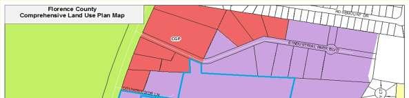
3 PC# Subject: Comprehensive Plan Map Amendment to change the land use map designation for property in Florence County located from Suburban Development to Industrial Growth and Preservation Tax Map Number 00153, Block 01, Parcel 026
4 PC# Cont d. Council District(s): 5; County Council Applicant: LarryMcLaughlin Land Area: 1 parcel, approximately 11.8 acres


5 PC# Aerial Map


6 PC# Land Use Map
7 PC# Background Staff Analysis: The property is currently designated as Suburban Development according to the Comprehensive Plan Land Use map. The applicant is proposing to change the designation to Industrial Growth and Preservation. Staff s Justification/Reason for the proposed amendment is to accommodate B-5 zoning.
8 PC# Staff Recommendation Approve as submitted.
9 PC# SUBJECT: Rezoning request from B-2, Convenience Business District to B-5, Office and Light Industrial District LOCATION: Property is located off of Industrial Park Blvd. Florence, SC TAX MAP NUMBER: 00153, Block 01, Parcel 026 COUNCIL DISTRICT(S): 5; County Council OWNER OF RECORD: Larry McLaughlin
10 PC# Cont d. APPLICANT: Larry McLaughlin LAND AREA: 11.8 Acres WATER /SEWER AVAILABILITY: Water services are provided by the City of Florence. No sewer availability. ADJACENT WATERWAYS/ BODIES OF WATER OF WATER There does not appear to be any waterway/ body of water adjacent to the property. FLOOD ZONE: N/A
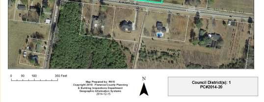
11 PC# Location Map

12 PC# Aerial Map


13 PC# Comprehensive Plan Map

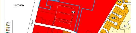

14 PC# Zoning Map


15 PC# Public Hearing Notice


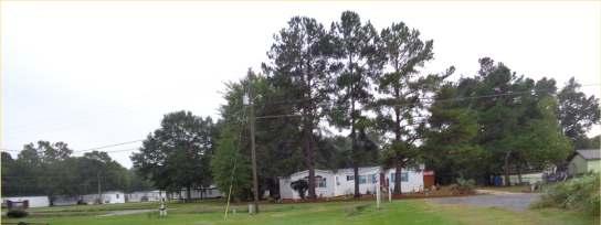
16 PC# Site Photograph of Property Surrounding Land Use and Zoning: West: Commercial Business/B-3/Town of Timmonsville

17 PC# Site Photograph of Property


18 PC# Site Photograph of Property


19 PC# Site Photograph of Property
20 PC# Background Cont d STAFF ANALYSIS: Existing Land Use and Zoning: The subject property is currently a commercial use and zoned B-2, Convenience Business District. Proposed Land Use and Zoning: The proposal is to rezone the subject property to B-5, Office and Light Industrial District.
21 PC# Background Cont d Surrounding Land Use and Zoning: North: Commercial Business/B-5/Florence County South: Mobile Home Park/B-2/Florence County West: Commercial Business/Single-Family Residential/Vacant Land/ B-2/Florence County East: Vacant Land/B-2/Florence County
22 PC# Background Cont d STAFF ANALYSIS (cont d) Transportation Access and Circulation: Present access to the property is by the way of Industrial Park Blvd. Traffic Review: The rezoning of this property will not have an effect on traffic flow for the area.
23 PC# Florence County Comprehensive Plan Currently, the subject property is located in a suburban Development area according to the Comprehensive Plan Land Use Map. The applicant has requested to rezone the property from B-2 to B-5. The request for the zoning amendment to B-5 does not comply with the Land Use Element s designation for the subject property. However, staff is moving forward with the request to amend the land use designation to Industrial growth and Preservation to comply with the Comprehensive Plan Land Use Map as the designation would coordinate with the existing land uses surrounding the area. When the amendment is approved for the land use designation change, the zoning amendment of the subject property from B-2 to B-5 will be in compliance.
24 PC# Chapter 30-Zoning Ordinance B-5, General Commercial District: The intent of the B-5, Office and Light Industrial District: The intent of this district is to promote the development of business parks, including offices, distribution, and light manufacturing uses in an environment suited to such uses and operations while promoting land use compatibility through the application of performance standards.
25 Approve as submitted. PC# Staff Recommendation
26 PC# Subject: Comprehensive Plan Map Amendment to change the land use map designation for properties in Olanta, SC, located on East Hampton St., from Residential Preservation to Suburban Development Tax Map Number 00045, Block 03, Parcels 027, 114 & 115
27 PC# Cont d. Council District(s): 1; County Council Applicant: James D.& Patsy F. McCutcheon Carolyn S. Floyd Paula F. White Land Area: 1 parcel, approximately 2.18 acres


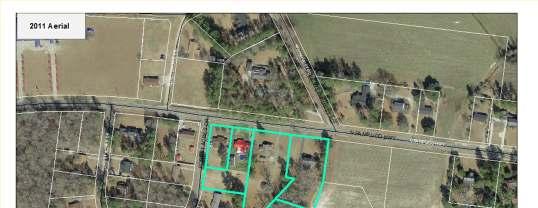
28 PC# Aerial Map


29 PC# Land Use Map
30 PC# Background Staff Analysis: The properties currently designated as Residential Preservation according to the Comprehensive Plan Land Use map. The applicant is proposing to change the designation to Suburban Development. Staff s Justification/Reason for the proposed amendment is to accommodate RU-1 zoning.
31 PC# Staff Recommendation Approve as submitted.
32 PC# SUBJECT: Rezoning request from R-1, Single Family Residential District to RU-1, Rural Community District LOCATION: Properties are located at 735 and 739 Hampton Street, Olanta, SC TAXMAPNUMBER: 00045,Block03,Parcel114,115,027 COUNCIL DISTRICT(S): 1; County Council OWNER OF RECORD: James D.& Patsy F. McCutcheon, Paula White, Carolyn Floyd
33 PC# Cont d. APPLICANT: James D. & Patsy F. McCutheon LAND AREA: 2.18 Acres WATER /SEWER AVAILABILITY: Water and Sewer is provided by Town of Olanta ADJACENT WATERWAYS/ BODIES OF WATER OF WATER There does not appear to be any waterway/ body of water adjacent to the property. FLOOD ZONE: N/A
34 PC# Location Map

35 PC# Aerial Map


36 PC# Comprehensive Plan Map


37 PC# Zoning Map


38 PC# Public Hearing Notice


39 PC# Site Photograph of Property Staff AnalysisExisting Land Use and Zoning: The subject property is a vacant convenience store and zoned R-3, Single-Family Residential District. Proposed Land Use and Zoning:The proposal is to rezone the subject property to B-3, General Commercial District, for future Commercial Opportunities.


40 PC# East of Property Surrounding Land Use and Zoning: West: Commercial Business/B-3/Town of Timmonsville


41 PC# West of Property


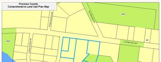
42 PC# South of Property
43 PC# Background Cont d STAFF ANALYSIS: Existing Land Use and Zoning: The subject properties are currently single-family residential, vacant land and a vacant building and currently zoned R-1, Single- Family Residential District. Proposed Land Use and Zoning: The proposal is to rezone the subject properties to RU-1, Rural Community District.
44 PC# Background Cont d Surrounding Land Use and Zoning: North: Vacant/ UZ/Town of Olanta South: Single-Family Residential District/R-1/Town of Olanta West: Vacant Building/R-1/Town of Olanta East: Vacant/R-1/Town of Olanta
45 PC# Background Cont d STAFF ANALYSIS (cont d) Transportation Access and Circulation: Present access to the properties are by the way of Hampton Street. Traffic Review: The rezoning of these properties will have minimal effect on traffic flow for the area.
46 PC# Florence County Comprehensive Plan Currently, the subject properties are located in a residential Preservation area according to the Comprehensive Plan Land Use Map. The applicant has requested to rezone the property from R-1 to RU-1. The request for the zoning amendment to RU-1 does not comply with the Land Use Element s designation for the subject property. However, staff is moving forward with the request to amend the land use designation to Suburban Development to comply with the Comprehensive Plan Land Use Map as the designation would coordinate with the existing land uses surrounding the area. When the amendment is approved for the land use designation change, the zoning amendment of the subject property from R-1 to RU-1 will be in compliance.
47 PC# Chapter 30-Zoning Ordinance The intent of the RU-1, Rural Community District: The intent of this district is to sustain and support rural community centers as an integral part of the rural environment, serving the commercial, service, social, and agricultural needs of nearby rural residents.
48 Approve as submitted. PC# Staff Recommendation
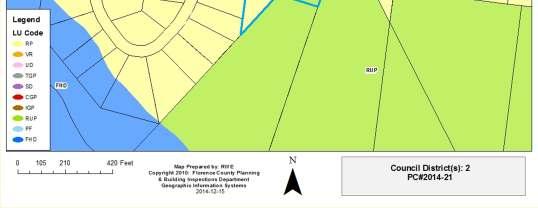
49 PC# Subject: Comprehensive Plan Map Amendment to change the land use map designation for properties in Pamplico, SC located from Residential Preservation to Rural Preservation Tax Map Number 00349, Block 02, Parcels 014, , Block 02, Parcels 001, 002
50 PC# Cont d. Council District(s): 2; County Council Applicant: Thadis D. Calcutt, Jr Land Area: 4 parcel, approximately 4.22 acres

51 PC# Aerial Map


52 PC# Land Use Map
53 PC# Background Staff Analysis: The subject properties are currently designated as Residential Preservation according to the Comprehensive Plan Land Use map. The applicant is proposing to change the designation to Rural Preservation.
54 PC# Staff Recommendation Staff recommends denial due to neighborhood complaints regarding a previous history of heavy commercial vehicles accessing an illegal commercial use of the property located at 520 N. Pamplico Hwy., Tax Map No
55 PC# SUBJECT: Rezoning request from R-1, Single-Family Residential District to RU-1, Rural Community District LOCATION: Properties are located at 502, 514, 520 and 524 N. Pamplico Hwy., Pamplico, SC TAXMAPNUMBER: 00349,Block02,Parcels014&035,and03491, Block 02, Parcels 001&002 COUNCIL DISTRICT(S): 2; County Council OWNEROFRECORD: ThadisD.CalcuttJr.,DaleF.Hanna,KennethW. Butler, Lynn K. Fitch
56 PC# Cont d. APPLICANT: ThadisD. CalcuttJr. LAND AREA: 4.22 Acres WATER /SEWER AVAILABILITY: Town of Pamplico, SC ADJACENT WATERWAYS/ BODIESOFWATER: None FLOOD ZONE: N/A
57 PC# Location Map
58 PC# Aerial Map
59 PC# Comprehensive Plan Map


60 PC# Zoning Map


61 PC# Meeting Notice


62 PC# Site Photography


63 PC# North of Property


64 PC# East of Property


65 PC# West of Property
66 PC# Background Cont d STAFF ANALYSIS: Existing Land Use and Zoning: The subject properties are currently single-family residential homes and currently zoned R-1, Single-Family Residential District. Proposed Land Use and Zoning: The proposal is to rezone the subject properties to RU-1, Rural Community District
67 PC# Background Cont d Surrounding Land Use and Zoning: North: Single-Family Residential District/R-1/Town of Pamplico South: Single-Family Residential District/Vacant land/r-1/town of Pamplico West: Single-Family Residential District/R-1/Town of Pamplico East: Vacant Land/UZ/R-1/Town of Pamplico
68 PC# Background Cont d STAFF ANALYSIS (cont d) Transportation Access and Circulation: Present access to the properties are by the way of PamplicoHwy. Traffic Review: The rezoning of this property will not have an effect on traffic flow for the area.
69 PC# Florence County Comprehensive Plan Currently, the subject properties are located in a residential Preservation area according to the Comprehensive Plan Land Use Map. The applicant has requested to rezone the properties from R-1 to RU-1. The request for the zoning amendment to RU-1 does not comply with the Land Use Element s designation for the subject property. However, staff is moving forward with the request to amend the land use designation to Rural Preservation to comply with the Comprehensive Plan Land Use Map as the designation would coordinate with the existing land uses surrounding the area. When the amendment is approved for the land use designation change, the zoning amendment of the subject property from R-1 to RU-1 will be in compliance.
70 PC# Chapter 30-Zoning Ordinance The intent of the RU-1, Rural Community District: The intent of this district is to sustain and support rural community centers as an integral part of the rural environment, serving the commercial, service, social, and agricultural needs of nearby rural residents.
71 PC# Staff Recommendation Staff recommends denial due to neighborhood complaints regarding a previous history of heavy commercial vehicles accessing an illegal commercial use of the property located at 520 N. Pamplico Hwy., Tax Map No
72 None Request for Plat/Plan Approval
73 None Other Business
74 Director s Report Summary Plats Building Reports
75 Executive Session (if needed) Adjournment
PC# Subject:
 PC# 2014-11 Subject: Comprehensive Plan Map Amendment to change the land use map designation for property in Florence County located from Suburban Development to Industrial Growth and Preservation Locations:
PC# SUBJECT: Rezoning request from R-3, Single-Family Residential District to R-3A, Single-Family Residential District.
 Agenda Cont d. PC#2012-01 SUBJECT: Rezoning request from R-3, Single-Family Residential District to R-3A, Single-Family Residential District. LOCATION: Properties located on E. & W. Marion St., N. & S.
PC# SUBJECT: APPLICANT: Florence County Planning Department
 PC#2012-04 SUBJECT: Text amendment request for Chapter 30 Zoning Ordinance, Article V. Sign Regulations for off-premise signage (billboards) of the Florence County Code. APPLICANT: Florence County Planning
Marion County Board of County Commissioners
 Marion County Board of County Commissioners Date: 6/28/2017 P&Z: 6/26/2017 BCC: 7/18/2017 Item Number 170701Z Type of Application Rezoning Request B-2, Community Business to R-1, Single Family Residential
PC# Request to change a PD, Planned Development. Property located at 781 St. Andrews Road. Tax Map Number: 00074, Block 01, Parcel 012
 PC# 2010-02 Subject: Location: Request to change a PD, Planned Development Property located at 781 St. Andrews Road Tax Map Number: 00074, Block 01, Parcel 012 Council District(s): Owner of Record: Applicant:
ZONING MAP CHANGE STAFF REPORT City Council Meeting Date: Council District 7 September 1, Knox Street Partners, No. 7, LTD
 Case Number ZONING MAP CHANGE STAFF REPORT City Council Meeting Date: Council District 7 September 1, 2015 Zoning Commission Recommendation: Approval by a vote of 9-0 Opposition: None submitted Support:
REZONING APPLICATION INSTRUCTIONS
 REZONING APPLICATION INSTRUCTIONS All required information, as stated on the Rezoning Application Checklist, must be included to qualify as a complete application. Upon receipt, staff will review the application
Marion County Planning & Zoning Commission
 Marion County Planning & Zoning Commission Date: /3/24 P&Z: 9/29/24 BCC: /21/24 Item Number 1409Z Type of Application Rezoning Request From: R-3, Multiple Family Residential To: B-4, Regional Business
Marion County Board of County Commissioners
 Marion County Board of County Commissioners Date: 4/26/26 P&Z: 4/25/26 BCC: 5/17/26 Item Number 160509Z Type of Application Request to rezone the property from the Rural Commercial (RC-1) District to the
PLANNING & DEVELOPMENT
 PLANNING & DEVELOPMENT STAFF REPORT Rezoning PETITION: APPLICANT: PROPERTY OWNER: TYPE OF REQUEST: SIZE OF TRACT: LOCATION: (#17-22) Rezone from A-PUD (Agri-Business Planned Unit Development) to A-PUD
City and County of Broomfield, Colorado
 City and County of Broomfield, Colorado CITY COUNCIL AGENDA MEMORANDUM To: From: Mayor and City Council George Di Ciero, City and County Manager Teri Malies, Principal Planner Terrance Ware, Planning Director
PLANNING COMMISSION REPORT Regular Agenda Public Hearing Item
 PC Staff Report 11/12/12 Item No. 2B- 1 PLANNING COMMISSION REPORT Regular Agenda Public Hearing Item ITEM NO. 2B: A TO GPI; 110 ACRES; E OF K-10 & N OF W 6 TH ST (MKM) : Consider a request to rezone approximately
Marion County Board of County Commissioners
 Marion County Board of County Commissioners Date: 12/29/2015 P&Z: 12/28/2015 BCC: 1/12/2016 Item Number 160113Z Type of Application Rezoning Request From: A-1 (General Agriculture) To: PUD (Planned Unit
Marion County Board of County Commissioners
 Marion County Board of County Commissioners Date: 12/2/25 P&Z: 11/30/25 BCC: 12/16/25 Amendment No: (20)151209Z Type of Application Rezoning Request P-MH (Mobile Home Park) to B-2 (Community Business)
Marion County Board of County Commissioners
 Marion County Board of County Commissioners Date: 10/29/25 P&Z: 10/26/25 BCC: 11/17/25 Item Number 151106SU Type of Application Special Use Permit Request Special Use Permit Modification to: 1. Add a secondary
Marion County Board of County Commissioners
 Marion County Board of County Commissioners Date: 12/2/2015 P&Z: 11/30/2015 BCC: 12/16/2015 Item Number 151210SU Type of Application Special Use Permit Request To establish a Clay Electric Co-Operative
TOWN OF ORO VALLEY PLANNING & ZONING COMMISSION MEETING DATE: December 6, 2011
 PLANNING & ZONING COMMISSION MEETING DATE: December 6, 2011 TO: FROM: SUBJECT: PLANNING & ZONING COMMISSION Matt Michels, Senior Planner mmichels@orovalleyaz.gov; tel. 229-4822 Public Hearing: Rancho de
Planning Department Oconee County, Georgia
 Planning Department Oconee County, Georgia STAFF REPORT REZONE CASE #: 6985 DATE: October 31, 2016 STAFF REPORT BY: Andrew C. Stern, Planner APPLICANT NAME: Williams & Associates, Land Planners PC PROPERTY
Agenda Information Sheet
 Page 90 Agenda Information Sheet December 13, 2018 Agenda Item Z-18-10 - Conduct a public hearing and consider approval of an ordinance rezoning a 33.4 tract of land out of the H. Teal Survey Abstract
CITY OF BELLEVIEW PLANNING & ZONING BOARD AGENDA
 CITY OF BELLEVIEW PLANNING & ZONING BOARD AGENDA BELLEVIEW CITY HALL COMMISSION ROOM 5:30 PM IF A PERSON SHOULD DESIRE TO APPEAL ANY DECISION MADE BY THE BOARD, A VERBATIM RECORD OF THE PROCEEDINGS WHICH
Marion County Planning & Zoning Commission
 Marion County Planning & Zoning Commission Date: 10/1/2013 P&Z: 10/28/2013 BCC: 11/19/2013 Item Number 131106Z Type of Application Rezoning Request Zoning change from R- 1 Single-Family Dwelling to R-4
MINUTES OF THE TOWN OF LADY LAKE REGULAR PLANNING AND ZONING BOARD MEETING LADY LAKE, FLORIDA. May 8, :30 p.m.
 MINUTES OF THE TOWN OF LADY LAKE REGULAR PLANNING AND ZONING BOARD MEETING LADY LAKE, FLORIDA May 8, 2017 5:30 p.m. The Planning and Zoning Board Meeting was held in the Town Hall Commission Chambers at
DEPARTMENT OF COMMUNITY DEVELOPMENT SERVICES. Planning Division. m e m o r a n d u m
 DEPARTMENT OF COMMUNITY DEVELOPMENT SERVICES Planning Division m e m o r a n d u m TO: FROM: The Urbana Zoning Board of Appeals Christopher Marx, AICP, Planner I DATE: December 15, 2017 SUBJECT: ZBA Case
CITY OF FLORENCE PLANNING COMMISSION AUGUST 9, 2016, 6:30 PM City Center, Council Chambers FLORENCE, SOUTH CAROLINA AGENDA
 CITY OF FLORENCE PLANNING COMMISSION AUGUST 9, 2016, 6:30 PM City Center, Council Chambers FLORENCE, SOUTH CAROLINA AGENDA I. Call to Order II. Approval of Minutes Regular Meeting July 12, 2016 III. IV.
Marion County Board of County Commissioners
 Marion County Board of County Commissioners Date: 10/27/2015 P&Z: 10/26/2015 BCC: 11/17/2015 Item Number 151104SU Type of Application Special Use Permit Request Parking of a Commercial Truck in the A-1
PLANNING COMMISSION PUBLIC HEARING STAFF REPORT ZRTD FAIRFAX MARBLE & GRANITE
 Date of Hearing: PLANNING COMMISSION PUBLIC HEARING STAFF REPORT SUBJECT: ELECTION DISTRICT: ZRTD-2016-0009 FAIRFAX MARBLE & GRANITE Broad Run CRITICAL ACTION DATE: September 27, 2017 STAFF CONTACTS: APPLICANT:
Ricker - PH / Planning and Zoning Commission Staff Report
 / Planning and Zoning Commission Staff Report Ricker - PH2018-20 Hearing Date: April 19, 2018 Development Services Department Applicant: Don Ricker Staff: Dan Lister, Planner II dlister@canyonco.org Tax
10 October 8, 2014 Public Hearing
 10 October 8, 2014 Public Hearing APPLICANT: THE STUDIO HAMPTON ROADS, L.L.C. PROPERTY OWNER: NORTH LANDING INVESTMENTS, L.L.C. STAFF PLANNER: Kevin Kemp REQUEST: Conditional Change of Zoning (Conditional
CHAPTER 50 LAND USE ZONES ARTICLE 50 BASIC PROVISIONS
 CHAPTER 50 LAND USE ZONES ARTICLE 50 BASIC PROVISIONS 50.010 - PURPOSE The purposes of this chapter are to establish land use zones required to implement the goals and policies of the Klamath County Comprehensive
1 September 9, 2015 Public Hearing
 1 September 9, 2015 Public Hearing APPLICANT & PROPERTY OWNER: HOLLOMON- BROWN FUNERAL HOME, INC. STAFF PLANNER: Carolyn A.K. Smith REQUEST: Change of Zoning (R-5D Residential District to Conditional O-2
PROPOSED FINDINGS OF FACT SUBMITTED TO THE ZONING BOARD OF APPEALS. In the Matter of a Special Use Application. for Address: Board Calendar No.
 PROPOSED FINDINGS OF FACT SUBMITTED TO THE ZONING BOARD OF APPEALS In the Matter of a Special Use Application for Address: Board Calendar No. Submitted by:, [check one] Applicant or Applicant s Attorney
PARISH OF ASCENSION OFFICE OF PLANNING AND DEVELOPMENT PLANNING DEPARTMENT. Zoning Meeting
 PARISH OF ASCENSION OFFICE OF PLANNING AND DEVELOPMENT PLANNING DEPARTMENT 1. Meeting Called to Order by Chairman 2. Roll Call of Members 3. Minutes (A) Zoning Meeting February 13, 2019 Courthouse Annex
PLEDGE OF ALLEGIANCE TO THE AMERICAN FLAG: WILLARD DORRIETY, JR., VICE CHAIRMAN
 Jason M. Springs District 1 Roger M. Poston District 2 Alphonso Bradley District 3 Mitchell Kirby District 4 Kent C. Caudle District 5 AGENDA with Additions FLORENCE COUNTY COUNCIL REGULAR MEETING COUNTY
STAFF REPORT. Community Development Director PO Box 4755 Beaverton, OR 97076
 STAFF REPORT HEARING DATE: July 7, 2010 TO: Planning Commission STAFF: Jana Fox, Assistant Planner PROPOSAL: Southeast Beaverton Office Commercial Zoning Map Amendment (ZMA2010-0006) LOCATION: The subject
Request Conditional Use Permits (Craft Brewery & Open-Air Market) Staff Recommendation Approval. Staff Planner Robert Davis
 Staff Recommendation Approval. Staff Planner Robert Davis") Applicant Property Owner Oceana Crossings, LLC Public Hearing November 14, 2018 City Council Election District Beach Agenda Item 2 Request Conditional Use Permits (Craft Brewery & Open-Air Market) Staff
Applicant Property Owner Oceana Crossings, LLC Public Hearing November 14, 2018 City Council Election District Beach Agenda Item 2 Request Conditional Use Permits (Craft Brewery & Open-Air Market) Staff
Mike & Sherry Dudley Rezone, RZ
 / Planning and Zoning Staff Report Mike & Sherry Dudley Rezone, RZ2019-0005 Hearing Date: April 18, 2019 Development Services Department Applicant: Mike & Sherry Dudley Staff: Deb Root, 454-7340 droot@canyonco.org
LAND USE. Land Cover. Current Land Use
 LAND USE Land Cover To begin the process at a more general level, land cover information was assembled to identify general patterns of developed/undeveloped areas. The data used to present this information
AGENDA. a. Carol Crews Special Exception Hair Salon (Continued from February) b. James Barber Special Exception Horse
 b. James Barber Special Exception Horse") Baker County Land Planning Agency (LPA) Thursday, April 23, 2015 Baker County Administration Building 55 North Third Street Macclenny, FL 32063 (904) 259-3354 AGENDA 5:OO P.M. LDR Mining Workshop A. Draft
Baker County Land Planning Agency (LPA) Thursday, April 23, 2015 Baker County Administration Building 55 North Third Street Macclenny, FL 32063 (904) 259-3354 AGENDA 5:OO P.M. LDR Mining Workshop A. Draft
Plans shall be drawn at a readable scale, signed, and sealed by a Florida Registered Engineer. The application package shall include:
 CHAPTER 400. SECTION 403. PERMIT TYPES AND APPLICATIONS SITE DEVELOPMENT 403.3. Preliminary Site Plans (PSP) A. Intent and Purpose PSPs are used to identify existing site conditions and demonstrate general
CITY OF DURHAM DURHAM COUNTY NORTH CAROLINA. Zoning Map Change Report. RR Existing Zoning. Rural Rural Density Residential Site Characteristics
 CITY OF DURHAM DURHAM COUNTY NORTH CAROLINA Zoning Map Change Report Meeting Date: February 26, 2007 Reference Name Arrowhead () Jurisdiction County Proposed Zoning RR Existing Zoning RS-20 Request Proposed
CITY OF TARPON SPRINGS Staff Report May 16, 2017
 CITY OF TARPON SPRINGS Staff Report May 16, 2017 TO: FROM: HEARING DATES: SUBJECT: MAYOR & BOARD OF COMMISSIONERS PLANNING & ZONING DEPARTMENT MAY 15, 2017 (PLANNING & ZONING BOARD) JUNE 6, 2017 (BOC 1
SUBDIVISION, PLANNED UNIT DEVELOPMENT, & REZONING STAFF REPORT Date: September 17, 2015
 SUBDIVISION, PLANNED UNIT DEVELOPMENT, & REZONING STAFF REPORT Date: September 17, 2015 APPLICANT NAME SUBDIVISION NAME DEVELOPMENT NAME LOCATION Daniel Clark Mack Manufacturing Subdivision, Resubdivision
7 December 9, 2015 Public Hearing
 7 December 9, 2015 Public Hearing APPLICANT: THE UNITARIAN CHURCH OF NORFOLK PROPERTY OWNER: SKANSKA USA CIVIL SOUTHEAST INC. STAFF PLANNER: Jimmy McNamara REQUEST: Conditional Use Permit (Religious Use)
PLEDGE OF ALLEGIANCE TO THE AMERICAN FLAG: WILLARD DORRIETY, JR., VICE CHAIRMAN
 Jason M. Springs District 1 Roger M. Poston District 2 Alphonso Bradley District 3 Mitchell Kirby District 4 Kent C. Caudle District 5 AGENDA (With Additions) FLORENCE COUNTY COUNCIL REGULAR MEETING COUNTY
Bethel Romanian Church - Rezone, RZ
 / Planning and Zoning Staff Report Bethel Romanian Church - Rezone, RZ2018-0023 Hearing Date: November 15, 2018 Development Services Department Owners: Bethel Romanian Church, Corp. Applicant: Viorel Botos
Mohave County General Plan
 63 64 65 66 67 68 69 70 71 The Land Use Diagram is not the County's zoning map. 13 It is a guide to future land use patterns. Zoning and area plan designations may be more restrictive than the land use
A G E N D A. BOARD OF ADJUSTMENT PUBLIC HEARING June 6, :00 PM GROWTH MANAGEMENT TRAINING FACILITY 2710 E. SILVER SPRINGS BLVD.
 A. Call to Order and Roll Call B. Invocation and Pledge of Allegiance A G E N D A BOARD OF ADJUSTMENT PUBLIC HEARING June 6, 2016 2:00 PM GROWTH MANAGEMENT TRAINING FACILITY 2710 E. SILVER SPRINGS BLVD.
SHEPHERD COMMUNITY ZONING STUDY SPECIAL STUDY. September 21, Regional Planning Agency
 SPECIAL STUDY SHEPHERD COMMUNITY ZONING STUDY September 21, 2007 Regional Planning Agency Chattanooga-Hamilton County Regional Planning Agency Development Resource Center 1250 Market Street Chattanooga,
Urban Planning and Land Use
 Urban Planning and Land Use 701 North 7 th Street, Room 423 Phone: (913) 573-5750 Kansas City, Kansas 66101 Fax: (913) 573-5796 Email: planninginfo@wycokck.org www.wycokck.org/planning To: From: City Planning
AGENDA PLANNING COMMISSION Tuesday, April 18, :00 PM City Council Chambers 125 East Avenue B, Hutchinson, Kansas
 AGENDA PLANNING COMMISSION Tuesday, April 18, 2017 5:00 PM City Council Chambers 125 East Avenue B, Hutchinson, Kansas 1. ROLL CALL Macklin Woleslagel Bisbee (Chair) Hamilton Peirce Vacant Carr Hornbeck
PLANNING COMMISSION REPORT PUBLIC HEARING ITEM. DE-ANNEXATION OF 2.4 ACRES LOCATED AT 1820 N. 3 rd STREET. (DDW)
") A-6-1-10 Item No. 5-1 PC Staff Report 9/20/10 PLANNING COMMISSION REPORT PUBLIC HEARING ITEM ITEM NO. 5: DE-ANNEXATION OF 2.4 ACRES LOCATED AT 1820 N. 3 rd STREET. (DDW) A-6-1-10: De-annexation of approximately
A-6-1-10 Item No. 5-1 PC Staff Report 9/20/10 PLANNING COMMISSION REPORT PUBLIC HEARING ITEM ITEM NO. 5: DE-ANNEXATION OF 2.4 ACRES LOCATED AT 1820 N. 3 rd STREET. (DDW) A-6-1-10: De-annexation of approximately
LINCOLN COUNTY PLANNING & INSPECTIONS DEPARTMENT
 LINCOLN COUNTY PLANNING & INSPECTIONS DEPARTMENT 302 NORTH ACADEMY STREET, SUITE A, LINCOLNTON, NORTH CAROLINA 28092 704-736-8440 OFFICE 704-736-8434 INSPECTION REQUEST LINE 704-732-9010 FAX To: Board
LOCATION MAP: AERIAL PHOTOGRAPH, 2015:
 LOCATION MAP: AERIAL PHOTOGRAPH, 2015: ORDINANCE NO. AN ORDINANCE OF THE CITY OF BRYAN, TEXAS, AMENDING CHAPTER 130, ZONING, OF THE CITY OF BRYAN CODE OF ORDINANCES, BY CHANGING THE ZONING CLASSIFICATION
City of Grand Island Tuesday, July 26, 2016 Council Session
 City of Grand Island Tuesday, July 26, 2016 Council Session Item E-2 Public Hearing on Request to Rezone Property located at 415 South Cherry Street from RD Residential Development to Amended RD Residential
THE CORPORATION OF THE TOWNSHIP OF NORWICH COMMITTEE OF ADJUSTMENT TUESDAY NOVEMBER 22, :00 P.M. COUNCIL CHAMBERS, NORWICH
 THE CORPORATION OF THE TOWNSHIP OF NORWICH COMMITTEE OF ADJUSTMENT TUESDAY NOVEMBER 22, 2016 7:00 P.M. COUNCIL CHAMBERS, NORWICH AGENDA Page 2-4 1. CALL TO ORDER 2. APPROVAL OF AGENDA 3. DISCLOSURE OF
Marion County Board of County Commissioners
 Marion County Board of County Commissioners Date: 10/4/26 P&Z: 9/26/26 BCC: 10/18/26 Item Number 161005SU Type of Application Special Use Permit Request Special Use Permit to allow a crematory as an accessory
Marion County Board of County Commissioners
 Marion County Board of County Commissioners Date: 6/4/217 P&Z: 9/25/217 BCC Transmittal: 1/17/217 BCC Adopt: TBD Amendment No: 217-L6 Type of Application Large-Scale Comp Plan Amendment Request: Change
PC Staff Report 11/18/2013 Z Item No. 1-1
 Z-13-00401 Item No. 1-1 PLANNING COMMISSION REPORT Regular Agenda - Public Hearing Item PC Staff Report 11/18/2013 ITEM NO. 1: Z-13-00401 IG (General Industrial) District TO CS (Strip Commercial) District;
8Land Use. The Land Use Plan consists of the following elements:
 8Land Use 1. Introduction The Land Use Plan consists of the following elements: 1. Introduction 2. Existing Conditions 3. Opportunities for Redevelopment 4. Land Use Projections 5. Future Land Use Policies
Urban Planning and Land Use
 Urban Planning and Land Use 701 North 7 th Street, Room 423 Phone: (913) 573-5750 Kansas City, Kansas 66101 Fax: (913) 573-5796 Email: planninginfo@wycokck.org www.wycokck.org/planning To: From: City Planning
Planning & Zoning Commission
 Planning & Zoning Commission Planning & Development Department August 14, 01 Zoning Map Amendment MAP-1-0001 (Bay View Section 4) Request Rezone approximately 1.19 acres from OS (Open Space) to RSF- (Residential
CASE # JR EXECUTIVE SUMMARY REZONING STAFF CONTACT: STEPHANIE LIENTZ
 CASE # JR16-0002 EXECUTIVE SUMMARY REZONING STAFF CONTACT: STEPHANIE LIENTZ OWNER/APPLICANT INFORMATION OWNER/APPLICANT: Donald & Martha Berner Michael & Sandra Wolrab MAILING ADDRESS: PO BOX 93 Mt Vernon,
Minutes of the Proceedings Laramie County Planning Commission Prepared by the Laramie County Planning & Development Office Laramie County Wyoming
 Minutes of the Proceedings Laramie County Planning Commission Prepared by the Laramie County Planning & Development Office Laramie County Wyoming Thursday, April 10, 2014 140410 00 The Laramie County Planning
REZONING STAFF REPORT Case: Jay Sikes, Mgr. of Planning Services Phone: (910) Fax: (910)
 Fax: (910)") REZONING Case: 15-67 Jay Sikes, Mgr. of Planning Services jsikes@harnett.org Phone: (910) 893-7525 Fax: (910) 814-8278 Planning Board: April 6, 2015 County Commissioners: April 20, 2015 Requesting a Rezoning
REZONING Case: 15-67 Jay Sikes, Mgr. of Planning Services jsikes@harnett.org Phone: (910) 893-7525 Fax: (910) 814-8278 Planning Board: April 6, 2015 County Commissioners: April 20, 2015 Requesting a Rezoning
Gadsden County Planning Commission Agenda Report
 Gadsden County Planning Commission Agenda Report Date of Meeting: June 16, 2016 To: From: Subject: Honorable Chairperson and Members of the Planning Commission Allara Mills Gutcher, AICP, Planning & Community
RAE EXCLUSIVE RESIDENTIAL ZONE A residential district exclusively for low density single family housing and accessory uses.
 KNOX COUNTY ZONING ORDINANCE DISTRICT SUMMARY REQUIREMENTS 2/11/2009 RAE EXCLUSIVE RESIDENTIAL ZONE A residential district exclusively for low density single family housing and accessory uses. 10,000 sq.
KNOXVILLE/KNOX COUNTY METROPOLITAN PLANNING COMMISSION REZONING REPORT
 KNOXVILLE/KNOX COUNTY METROPOLITAN PLANNING COMMISSION REZONING REPORT FILE #: 7-F-7-RZ AGENDA ITEM #: AGENDA DATE: 7/3/207 APPLINT: OWNER(S): RITA NEUBERT STATEWIDE REALTY INC. Statewide Realty, Inc TAX
ZONING PERMIT APPLICATION
 ZONING PERMIT APPLICATION OFFICE USE ONLY Date Received: FILE NO. 120 DAY EXPIRATION Purpose: Some types of land use activities listed in the Lake County Zoning Ordinance are allowed to occur with a minimal
PLANNING DIVISION COMMUNITY & ECONOMIC DEVELOPMENT. To: Salt Lake City Planning Commission. PLNPCM John Glenn Road Zoning Map Amendments
 Staff Report PLANNING DIVISION COMMUNITY & ECONOMIC DEVELOPMENT To: Salt Lake City Planning Commission From: John Anderson, 801-535-7214, john.anderson@slcgov.com Date: March 22, 2017 Re: PLNPCM2017-00063
REPORT TO PLANNING & ZONING COMMISSION - CITY OF MARYLAND HEIGHTS
 REPORT TO PLANNING & ZONING COMMISSION - CITY OF MARYLAND HEIGHTS APPLICATION NUMBER APPLICATION (PROJECT) NAME APPLICANT NAME PROPERTY OWNER CUP16-0008 HSL SPORTS SPORTPORT HSL Sports, LLC c/o Greensfelder,
EDGERTON CITY HALL PLANNING COMMISSION MEETING REGULAR SESSION March 12, 2019
 EDGERTON CITY HALL PLANNING COMMISSION MEETING REGULAR SESSION The met in regular session with Chair John Daley calling the meeting to order at 7:00 p.m. All present participated in the Pledge of Allegiance.
4 August 13, 2014 Public Hearing
 4 August 13, 2014 Public Hearing APPLICANT & PROPERTY OWNER: LILLEL FARMS, INC. STAFF PLANNER: Kristine Gay REQUEST: Change of Zoning (Conditional PDH-2 with A-24 Apartment Zoning District to P-1 Preservation
CITY OF FLORENCE PLANNING COMMISSION JANUARY 10, :30 PM City Center, Council Chambers FLORENCE, SOUTH CAROLINA AGENDA
 CITY OF FLORENCE PLANNING COMMISSION JANUARY 10, 2017 6:30 PM City Center, Council Chambers FLORENCE, SOUTH CAROLINA AGENDA I. Election of officers II. III. IV. Review and approval of 2017 meeting schedule
Planning Commission Agenda April 16, 2019
 Planning Commission Agenda April 16, 2019 I. Call to Order II. Approval of Minutes III. New Business 1. Rose Properties, LLC Rezoning* (R-1, Single-Family Residential to C-2, General Commercial) 1253 SW
PARISH OF ASCENSION OFFICE OF PLANNING AND DEVELOPMENT PLANNING DEPARTMENT
 PARISH OF ASCENSION OFFICE OF PLANNING AND DEVELOPMENT PLANNING DEPARTMENT 1. Meeting Called to Order by Chairman 2. Roll Call of Members 3. Pledge of Allegiance 4. Introduction of Staff 5. Minutes (A)
PUBLIC NOTICE PLANNING COMMISSION MEETING COUNCIL CHAMBER 1801 E. AIRLINE HWY., LAPLACE LOUISIANA MONDAY, OCTOBER 15, :30 P.M.
 PUBLIC NOTICE PLANNING COMMISSION MEETING COUNCIL CHAMBER 1801 E. AIRLINE HWY., LAPLACE LOUISIANA MONDAY, OCTOBER 15, 2018 6:30 P.M. AGENDA I. Call to Order II. III. IV. Roll Call Opening Prayer/Pledge
PLANNING COMMISSION REPORT Regular Agenda - Public Hearing Item
 Z-14-00056 Item No. 1-1 PLANNING COMMISSION REPORT Regular Agenda - Public Hearing Item PC Staff Report 4/21/2014 ITEM NO. 1: RSO TO CN1;.126 ACRES; 512 & 514 LOCUST ST (DRG) Z-14-00056: Consider a request
BILL ESTES FORD EXPANSION. APPLICATION FOR ZONING MAP AMENDMENT Docket Nos. PCMA June 12, 2014 Town of Brownsburg Town Council
 BILL ESTES FORD EXPANSION APPLICATION FOR ZONING MAP AMENDMENT Docket Nos. PCMA-04-14-1211 June 12, 2014 Town of Brownsburg Town Council Applicant: Attorneys: Bill Estes Ford Nelson & Frankenberger, P.C.
PLANNING AND ZONING COMMISSION MARCH 28, 2018 CITY HALL S COUNCIL 5:00 P.M.
 PLANNING AND ZONING COMMISSION MARCH 28, 2018 CITY HALL S COUNCIL CHAMBERS @ 5:00 P.M. P&Z PRESENT P&Z ABSENT STAFF PRESENT GUESTS PRESENT Ned Sheats Julio Cerda Jaime Acevedo Carlos Chapa John R. Guerra
UDC Dimensional Standards
 UDC Dimensional Standards This document includes basic information regarding lot dimensions, setback and other lot standards. For full, up-to-date, information, you may wish to refer to the Unified Development
ACTION FORM BRYAN CITY COUNCIL
 ACTION FORM BRYAN CITY COUNCIL DATE OF COUNCIL MEETING: July 8, 2014 DATE SUBMITTED: June 17, 2014 DEPARTMENT OF ORIGIN: Development Services SUBMITTED BY: Maggie Dalton MEETING TYPE: CLASSIFICATION: ORDINANCE:
301. Zoning Districts. C-D A-1 R-1 R-V B-1 I-1
 301. Zoning Districts. The Township is divided into the districts set forth by this chapter and as shown by the district boundaries on the Official Zoning District Map. The zoning districts are: C-D Conservation
Town zoning: A good option for your town?
 Photo credit: Landslides Aerial Photography Town zoning: A good option for your town? Lynn Markham Town of Auburn May 27, 2015 Main points 1. Zoning is one tool to implement community plans 2. What does
SANTA BARBARA COUNTY PLANNING COMMISSION Staff Report for Bosshardt Appeal of Planning and Development Denial of Land Use Permit 06LUP
 SANTA BARBARA COUNTY PLANNING COMMISSION Staff Report for Bosshardt Appeal of Planning and Development Denial of Land Use Permit 06LUP-00000-00245 Deputy Director: Zoraida Abresch Staff Report Date: October
2017 (X) OFFICIAL ( ) UNOFFICIAL TOWNSHIP ZONING REVIEW Monroe County, Michigan
 OFFICIAL ( ) UNOFFICIAL TOWNSHIP ZONING REVIEW Monroe County, Michigan") 2017 (X) OFFICIAL ( ) UNOFFICIAL TOWNSHIP ZONING REVIEW Monroe County, Michigan MEMORANDUM DATE: September 13, 2017 TOWNSHIP: Ash TO: Monroe County Planning Commission SECTION/P.C.: 34 FROM: Staff AERIAL
2017 (X) OFFICIAL ( ) UNOFFICIAL TOWNSHIP ZONING REVIEW Monroe County, Michigan MEMORANDUM DATE: September 13, 2017 TOWNSHIP: Ash TO: Monroe County Planning Commission SECTION/P.C.: 34 FROM: Staff AERIAL
Urban Planning and Land Use
 Urban Planning and Land Use 701 North 7 th Street, Room 423 Phone: (913) 573-5750 Kansas City, Kansas 66101 Fax: (913) 573-5796 Email: planninginfo@wycokck.org www.wycokck.org/planning To: From: City Planning
LINCOLN COUNTY PLANNING & INSPECTIONS DEPARTMENT
 LINCOLN COUNTY PLANNING & INSPECTIONS DEPARTMENT 302 NORTH ACADEMY STREET, SUITE A, LINCOLNTON, NORTH CAROLINA 28092 704-736-8440 OFFICE 704-736-8434 INSPECTION REQUEST LINE 704-732-9010 FAX To: Board
AGENDA ITEM. Two Separate Public Hearings relating to the Eighth Avenue S./Orange Place Enclave Annexation
 DATE PREPARED: May 20, 2015 AGENDA ITEM PREPARED BY: Marisa M. Barmby, AICP, Senior Planner Central Florida Regional Planning Council AGENDA DATE: June 1, 2015 and June 8, 2015 REQUESTED ACTION: Two Separate
Marion County Board of County Commissioners
 Marion County Board of County Commissioners Date: 12/2/2015 P&Z: 11/30/2015 BCC: 12/16/2015 Amendment No: 2015-S05 Type of Application Small Scale FLUMS Amendment Request Rural Land to Rural Activity Center
PLANNING COMMISSION REPORT Regular Agenda Public Hearing Item
 PC Staff Report 6/20/16 Item No. 4-1 PLANNING COMMISSION REPORT Regular Agenda Public Hearing Item PC Staff Report 06/20/16 ITEM NO. 4: IG to CS 1.56 ACRES; 706 E 23 RD STREET (MKM) : Consider a request
REZONING STAFF REPORT Case: Jay Sikes, Mgr of Planning Services Phone: (910) Fax: (910)
 Fax: (910)") REZONING Case: 14-164 Jay Sikes, Mgr of Planning Services jsikes@harnett.org Phone: (910) 893-7525 Fax: (910) 814-8278 Planning Board: June 2, 2014 County Commissioners: June 16, 2014 Requesting a Rezoning
REZONING Case: 14-164 Jay Sikes, Mgr of Planning Services jsikes@harnett.org Phone: (910) 893-7525 Fax: (910) 814-8278 Planning Board: June 2, 2014 County Commissioners: June 16, 2014 Requesting a Rezoning
CITY OF SANTA ROSA COMMUNITY DEVELOPMENT DEPARTMENT STAFF REPORT FOR PLANNING COMMISSION SEPTEMBER 10, 2015 APPLICANT FILE NUMBER MJP
 ITEM NO. 9 CITY OF SANTA ROSA COMMUNITY DEVELOPMENT DEPARTMENT STAFF REPORT FOR PLANNING COMMISSION SEPTEMBER 10, 2015 PROJECT TITLE Yogurt Time Center ADDRESS/LOCATION 3093 Marlow Road ASSESSOR S PARCEL
Planning & Zoning Commission Meeting Date: 02/07/2018 Submitted By: Janice Pokrant, Engineering Department. 4.a. Information SUBJECT:
 Planning & Zoning Commission Meeting Date: 02/07/2018 Submitted By: Janice Pokrant, Engineering Department 4.a. SUBJECT: Information Conduct a Public Hearing and Consider a Request For Plat 18-01 by Abner
Urban Planning and Land Use
 Urban Planning and Land Use 701 North 7 th Street, Room 423 Phone: (913) 573-5750 Kansas City, Kansas 66101 Fax: (913) 573-5796 Email: planninginfo@wycokck.org www.wycokck.org/planning To: From: City Planning
ARTICLE 2 ZONING DISTRICTS AND MAPS
 ARTICLE 2 ZONING DISTRICTS AND MAPS SECTION 2.100 PURPOSE OF DISTRICTS Section 2.101. For the purpose of this Ordinance, Billings Township is hereby divided into districts as follows: DISTRICT NAME SYMBOL
Planning Department Oconee County, Georgia STAFF REPORT
 Planning Department Oconee County, Georgia STAFF REPORT REZONE CASE #: 7332 DATE: November 28, 2017 STAFF REPORT BY: Gabriel Quintas, Planner APPLICANT NAME: Smith Planning Group PROPERTY OWNER: John Hadden
CITY OF WEST PALM BEACH PLANNING BOARD Meeting Date: July 17, 2018 Planning Board Case No. 1670I
 CITY OF WEST PALM BEACH PLANNING BOARD Meeting Date: July 17, 2018 Planning Board Case No. 1670I Palms Gateway Commercial Planned Development (CPD) Southeast Corner of Belvedere Road and Australian Avenue
PLANNING AND ZONING COMMISSION / BOARD OF ADJUSTMENT AGENDA
 PLANNING AND ZONING COMMISSION / BOARD OF ADJUSTMENT AGENDA CITY HALL, COUNCIL CHAMBERS, 5TH FLOOR, 405 6TH STREET, SIOUX CITY, IA May 22, 2018-4:00 P.M. (Said items are on file in Room 308, City Hall,
ADMINISTRATIVE REPORT
 ADMINISTRATIVE REPORT TO: FROM: Advisory Planning Commission B. Newell, Chief Administrative Officer DATE: October 11, 2016 RE: Temporary Use Permit Application Electoral Area D Purpose: Owners: To allow
ARLINGTON COUNTY, VIRGINIA. County Board Agenda Item Meeting of February 25, 2017
 ARLINGTON COUNTY, VIRGINIA County Board Agenda Item Meeting of February 25, 2017 DATE: February 17, 2017 SUBJECT: Ordinance of Vacation to vacate the southern one-half of a portion of a public alley abutting