LOCATION MAP: AERIAL PHOTOGRAPH, 2015:
|
|
|
- Nigel Amos McDaniel
- 5 years ago
- Views:
Transcription


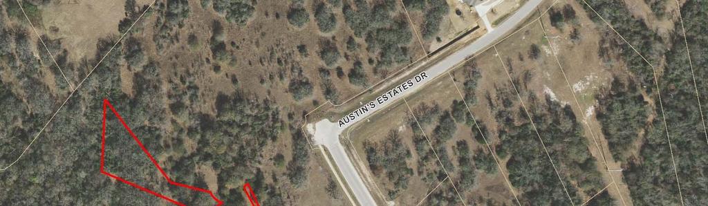
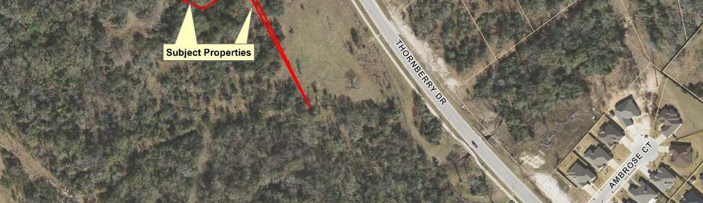
1 LOCATION MAP: AERIAL PHOTOGRAPH, 2015:
2 ORDINANCE NO. AN ORDINANCE OF THE CITY OF BRYAN, TEXAS, AMENDING CHAPTER 130, ZONING, OF THE CITY OF BRYAN CODE OF ORDINANCES, BY CHANGING THE ZONING CLASSIFICATION FROM AGRICULTURAL - OPEN DISTRICT (A-O) TO RESIDENTIAL DISTRICT 7000 (RD-7), ON ACRES OF LAND OUT OF THE JOHN AUSTIN LEAGUE, A- 2, LOCATED GENERALLY WEST OF THE INTERSECTION OF THORNBERRY AND AUSTIN S ESTATES DRIVES, IN BRYAN, BRAZOS COUNTY, TEXAS; REPEALING ALL ORDINANCES OR PARTS OF ORDINANCES IN CONFLICT HEREWITH; PROVIDING A SAVINGS CLAUSE; PROVIDING A SEVERABILITY CLAUSE; FINDING AND DETERMINING THAT THE MEETINGS AT WHICH SAID ORDINANCE IS PASSED ARE OPEN TO THE PUBLIC AS REQUIRED BY LAW; AND PROVIDING AN EFFECTIVE DATE. WHEREAS, the City of Bryan has adopted Chapter 130, Zoning, of the City of Bryan Code of Ordinances, as amended, which divides the City of Bryan into various zoning districts; and WHEREAS, permanent zoning changes made after the date of passage of Chapter 130 are made by adopting ordinances amending Chapter 130 for each particular permanent zoning change; and WHEREAS, this requested change to amend Chapter 130, Zoning, of the City of Bryan Code of Ordinances, by changing the zoning classification Agricultural - Open District (A-O) to Residential District 7000 (RD-7) on acres of land out of the John Austin League, A-2, located generally west of the intersection of Thornberry and Austin s Estates Drives, in Bryan, Brazos County, Texas, was recommended for approval by the Bryan Planning and Zoning Commission during its regular meeting on May 4, 2017 (case no. RZ17-08); NOW, THEREFORE, BE IT ORDAINED BY THE CITY COUNCIL OF THE CITY OF BRYAN, TEXAS: 1. That Chapter 130, Zoning, of the City of Bryan Code of Ordinances be amended by changing the zoning classification from Agricultural Open District (A-O) to Residential District 7000 (RD-7) on acres of land out of the John Austin League, A-2, located generally west of the intersection of Thornberry and Austin s Estates Drives, in Bryan, Brazos County, Texas, said acres being described more particularly by metes-and-bounds on attached Exhibit A, and depicted on attached Exhibit B. 2. That all ordinances or parts of ordinances in conflict with the provisions of this ordinance are hereby repealed. 3. Should any section, paragraph, sentences, clause, phrase or word of this ordinance be declared unconstitutional or invalid for any purpose by a court of competent jurisdiction, the remainder of this ordinance shall not be affected thereby, and to this end the provisions of this ordinance are declared to be severable.
3 4. The Code of the City of Bryan, Texas, as amended, shall remain in full force and effect, save and except as amended by this ordinance. 5. It is hereby found and determined that the meetings at which this ordinance was passed were open to the public as required by Section et seq., Texas Government Code, and that advance public notice of time, place and purpose of said meetings was given. 6. This ordinance shall take effect immediately upon its second and final reading and passage. PRESENTED AND GIVEN first reading the 6 th day of June, 2017 at a regular meeting of the City Council of the City of Bryan, Texas; and given second reading, PASSED AND APPROVED on the 13 th day of June, 2017 by a vote of yeses and noes at a regular meeting of the City Council of the City of Bryan, Texas. ATTEST: CITY OF BRYAN: Mary Lynne Stratta, City Secretary Andrew Nelson, Mayor APPROVED AS TO FORM: Janis K. Hampton, City Attorney
4 Exhibit A : METES-AND-BOUNDS DESCRIPTION OF TWO TRACTS TOTALLING ACRES JOHN AUSTIN LEAGUE, A-2 BRYAN, BRAZOS COUNTY, TEXAS Tract 1 (0.928 acres): METES AND BOUNDS DESCRIPTION OF ALL THAT CERTAIN TRACT OF LAND LYING AND BEING SITUATED IN THE JOHN AUSTIN LEAGUE, ABSTRACT NO. 8, BRYAN, BRAZOS COUNTY, TEXAS. SAID TRACT BEING A PORTION OF THE REMAINDER OF A CALLED ACRE TRACT OF LAND AS DESCRIBED BY A DEED TO 88 JOINT VENTURE RECORDED IN VOLUME 1029, PAGE 850 OF THE OFFICIAL PUBLIC RECORDS OF BRAZOS COUNTY, TEXAS. SAID TRACT BEING MORE PARTICULARLY DESCRIBED BY METES AND BOUNDS AS FOLLOWS: COMMENCING AT A ½ INCH IRON ROD WITH PLASTIC CAP MARKED KERR 4502 FOUND (N: , E: ) ON THE SOUTHEAST LINE OF A CALLED ACRE TRACT OF LAND AS DESCRIBED AS EXHIBIT 'A' BY A DEED TO DOROTHY B. RIZZO RECORDED IN VOLUME 6676, PAGE 195 OF THE OFFICIAL PUBLIC RECORDS OF BRAZOS COUNTY, TEXAS. SAID IRON ROD FOUND MARKING THE WEST CORNER OF LOT 6, BLOCK 3, AUSTIN'S ESTATES PHASE 4B, ACCORDING TO THE PLAT RECORDED IN VOLUME 7912, PAGE 22 OF THE OFFICIAL PUBLIC RECORDS OF BRAZOS COUNTY, TEXAS. FOR REFERENCE, THE CITY OF BRYAN CONTROL MONUMENT SWG A-53-W BEARS: N 12 25' 16" E FOR A DISTANCE OF FEET. COORDINATES AND BEARING SYSTEM SHOWN HEREIN ARE NAD83 (TEXAS STATE PLANE CENTRAL ZONE GRID NORTH) BASED ON THE PUBLISHED COORDINATES OF THE CITY OF BRYAN CONTROL MONUMENT SWG A-53-W (N: , E: ) AND AS ESTABLISHED BY GPS OBSERVATION; THENCE: S 38 02' 26" W THROUGH SAID REMAINDER OF ACRE TRACT FOR A DISTANCE OF FEET TO THE POINT OF BEGINNING (N: , E: ) OF THIS HEREIN DESCRIBED TRACT; THENCE: THROUGH SAID REMAINDER OF ACRE TRACT FOR THE FOLLOWING CALLS: S 38 23' 43" E FOR A DISTANCE OF FEET TO A POINT; S 76 08' 10" E FOR A DISTANCE OF FEET TO A POINT MARKING THE BEGINNING OF A COUNTER-CLOCKWISE CURVE HAVING A RADIUS OF FEET; ALONG SAID CURVE THROUGH A CENTRAL ANGLE OF 51 11' 27" FOR AN ARC DISTANCE OF FEET (CHORD BEARS: S 34 38' 05" E FEET) TO A POINT MARKING THE END POINT OF SAID CURVE; S 59 51' 07" W FOR A DISTANCE OF FEET TO A ½ INCH IRON ROD WITH PLASTIC CAP MARKED KERR 4502 SET;
5 N 67 33' 49" W FOR A DISTANCE OF FEET TO A ½ INCH IRON ROD WITH PLASTIC CAP MARKED KERR 4502 SET; N 04 23' 05" E FOR A DISTANCE OF FEET TO THE POINT OF BEGINNING CONTAINING OF AN ACRE OF LAND (40,436 SQUARE FEET) AS SURVEYED ON THE GROUND. Tract 2 (0.070 acres): METES AND BOUNDS DESCRIPTION OF ALL THAT CERTAIN TRACT OF LAND LYING AND BEING SITUATED IN THE JOHN AUSTIN LEAGUE, ABSTRACT NO. 8, BRYAN, BRAZOS COUNTY, TEXAS. SAID TRACT BEING A PORTION OF THE REMAINDER OF A CALLED ACRE TRACT OF LAND AS DESCRIBED BY A DEED TO 88 JOINT VENTURE RECORDED IN VOLUME 1029, PAGE 850 OF THE OFFICIAL PUBLIC RECORDS OF BRAZOS COUNTY, TEXAS. SAID TRACT BEING MORE PARTICULARLY DESCRIBED BY METES AND BOUNDS AS FOLLOWS: COMMENCING AT A ½ INCH IRON ROD WITH PLASTIC CAP MARKED KERR 4502 FOUND (N: , E: ) ON THE SOUTHEAST LINE OF A CALLED ACRE TRACT OF LAND AS DESCRIBED AS EXHIBIT 'A' BY A DEED TO DOROTHY B. RIZZO RECORDED IN VOLUME 6676, PAGE 195 OF THE OFFICIAL PUBLIC RECORDS OF BRAZOS COUNTY, TEXAS. SAID IRON ROD FOUND MARKING THE WEST CORNER OF LOT 6, BLOCK 3, AUSTIN'S ESTATES PHASE 4B, ACCORDING TO THE PLAT RECORDED IN VOLUME 7912, PAGE 22 OF THE OFFICIAL PUBLIC RECORDS OF BRAZOS COUNTY, TEXAS. FOR REFERENCE, THE CITY OF BRYAN CONTROL MONUMENT SWG A-53-W BEARS: N 12 25' 16" E FOR A DISTANCE OF FEET. COORDINATES AND BEARING SYSTEM SHOWN HEREIN ARE NAD83 (TEXAS STATE PLANE CENTRAL ZONE GRID NORTH) BASED ON THE PUBLISHED COORDINATES OF THE CITY OF BRYAN CONTROL MONUMENT SWG A-53-W (N: , E: ) AND AS ESTABLISHED BY GPS OBSERVATION; THENCE: S 00 26' 27" W THROUGH SAID REMAINDER OF ACRE TRACT FOR A DISTANCE OF FEET TO THE POINT OF BEGINNING (N: , E: ) OF THIS HEREIN DESCRIBED TRACT; THENCE: THROUGH SAID REMAINDER OF ACRE TRACT FOR THE FOLLOWING CALLS: N 28 34' 50" W FOR A DISTANCE OF FEET TO A POINT MARKING THE BEGINNING OF A CLOCKWISE CURVE HAVING A RADIUS OF FEET; ALONG SAID CURVE THROUGH A CENTRAL ANGLE OF 36 52' 09" FOR AN ARC DISTANCE OF FEET (CHORD BEARS: N 41 25' 00" E FEET) TO A POINT MARKING THE END POINT OF SAID CURVE; S 26 31' 08" E FOR A DISTANCE OF FEET TO THE POINT OF BEGINNING CONTAINING OF AN ACRE OF LAND (3,040 SQUARE FEET) AS SURVEYED ON THE GROUND.
6 Exhibit B :
7 EXCERPT FROM PLANNING AND ZONING COMMISSION REGULAR MEETING MINUTES OF MAY 4, 2017: 8. REQUESTS FOR APPROVAL OF ZONING CHANGES A PUBLIC HEARING WILL BE HELD FOR EACH ITEM (Commission makes recommendation; City Council has final approval). a. Rezoning RZ17-08: Highland Interests A request to change the zoning classification from Agricultural - Open District (A-O) to Residential District (RD-7) on two vacant tracts, being a total of acres of land out of the John Austin League, A-2, located generally west of the intersection of Thornberry and Austin s Estates Drives in Bryan, Brazos County, Texas. (A. Kay) Ms. Kay presented the staff report (on file in the Development Service Department). Staff recommends approval of the request. The public hearing was opened. No one came forward. The public hearing was closed. Commissioner Swearingen moved to recommend approval of Rezoning RZ17-08 to the Bryan City Council, and to adopt the written staff report and analysis, as the report, findings and evaluation of the Commission. Commissioner Conlee seconded the motion, and the motion passed unanimously.
8 PLANNING AND ZONING COMMISSION STAFF REPORT May 4, 2017 Rezoning case no. RZ17-08: Highland Interests CASE DESCRIPTION: LOCATION: EXISTING LAND USE: APPLICANT(S): AGENT: STAFF CONTACT: a request to change the zoning classification from Agricultural - Open District (A-O) to Residential District (RD-7) acres of land out of the John Austin League, A-2, located generally west of the intersection of Thornberry and Austin s Estates Drives vacant land Grant Carrabba of Highland Interests Michael Hester, P.E. Allison Kay, Staff Planner SUMMARY RECOMMENDATION: Staff recommends approving the proposed rezoning.
9 AERIAL PHOTOGRAPH (2015): BACKGROUND: The applicant/property owner, Mr. Grant Carrabba of Highland Interests, is requesting to change the zoning on the subject property from Agricultural-Open District (A-O) to Residential District 7000 (RD-7), to permit the proposed development of a new residential subdivision. On May 24, 2016, the City Council approved a similar rezoning request for the adjacent acres of vacant land, which are also proposed to be part of this new subdivision. New topographical information found less floodplain than originally anticipated. The two parcels, totaling acres of land, are proposed to become part of the proposed Austin s Estates Subdivision Phase 6, on a total of acres. The subject properties are located generally west of the intersection of Thornberry and Austin s Estates Drives. A master plan for Austin s Estates Subdivision proposing a low-density residential development at this location originally envisioned to be part of Phase 5 was approved by the Planning and Zoning Commission on June 1, The A-O zoning classification is intended to provide opportunities for development of low density, detached single-family residences on lots of at least one acre in a suburban or rural setting. This zoning classification is also intended to serve as a holding zone for vacant land areas annexed to the City as well as to protect areas that may be unsuitable for development and to preserve natural open space. The RD-7 zoning classification is intended to provide opportunities for development of detached dwellings on lots of at least 7,000 square feet in size.
10 AUSTIN S ESTATES MASTER PLAN (approved June 1, 2006):
11 ACREAGE REZONED TO RD-7 DISTRICT (APPROVED MAY 24, 2016):
12 PROPOSED TRACTS TO BE REZONED RD-7 DISTRICT WITH THIS REQUEST:

13 RELATION TO BRYAN S COMPREHENSIVE PLAN: The City of Bryan s Comprehensive Plan ( BluePrint 2040 ) includes policy recommendations related to the various physical development aspects of the community. The plan includes policy recommendations related to the various physical development aspects of the community. The Comprehensive Plan states that it is a goal of the City to achieve a balanced and sustainable mix of land uses within the City by planning for a mix of land use types in suitable locations, densities and patterns. Low-density residential land serves to provide housing and living units for a variety of people with a range of incomes and needs. It predominantly consists of detached single family dwellings but may consist of other housing types as long as densities remain low; up to 8 dwelling units per acre. City-wide land use policies articulated in the Comprehensive Plan suggest that single-family residential land uses should be located in areas that are protected from, but accessible to the major roadway network, commercial establishments, work places and entertainment areas.
14 ANALYSIS: In making its recommendation regarding a proposed zoning change, the Planning and Zoning Commission shall consider the following factors. 1. Whether the uses permitted by the proposed change will be appropriate in the immediate area concerned; relationship to general area and the City as a whole. Staff believes that RD-7 zoning on these acres is appropriate at this particular location and is not only in accordance with land use recommendations of the Comprehensive Plan, but also with the approved master plan for the Austin s Estates Subdivision. Staff believes that singlefamily residences on this land, when combined with the previously-rezoned acres, will promote orderly urban growth in close proximity to Harvey Mitchell Elementary School. Most of the existing Austin s Estates Subdivision, located northeast of the subject property, is already zoned RD-7 District. 2. Whether the proposed change is in accord with any existing or proposed plans for providing public schools, streets, water supply, sanitary sewers, and other utilities to the area and shall note the findings. Residential neighborhoods should be planned such that they form cohesive environments oriented toward elementary schools at their core. In this particular case, this proposed lowdensity residential subdivision is located near Harvey Mitchell Elementary School (approximately 0.5 mile southwest) and will have access to collector streets (Austin s Estates and Thornberry Drives). Any issues regarding utility capacity will be addressed at the time of development. 3. The amount of vacant land currently classified for similar development in the vicinity and elsewhere in the City, and any special circumstances which may make a substantial part of such vacant land unavailable for development. The closest vacant land zoned for residential development is located southeast from the subject property in the Austin s Colony Subdivision Phases 14 and 15. Staff believes that this zone change request, if approved, will not make land classified for similar development in the vicinity and elsewhere in the City unavailable for development. 4. The recent rate at which land is being developed in the same zoning classification as the request, particularly in the vicinity of the proposed change. Staff contends that residential developments are developing at a fast pace in this vicinity and at a moderate pace elsewhere in the City. 5. How other areas designated for similar development will be, or are unlikely to be affected if the proposed amendment is approved, and whether such designation for other areas should be modified also. If the proposed zone change was approved, staff believes there to be few, if any, effects on other areas designated for similar developments. 6. Any other factors affecting health, safety, morals, or general welfare. Staff is unable to identify additional factors other than those mentioned above that might affect
15 health, safety, morals, or general welfare if this rezoning were approved. RECOMMENDATION: Based on all these considerations, staff recommends approving the requested zone change to Residential District 7000 on the subject properties. RD-7 zoning on this property is consistent with the land use recommendations of the Comprehensive Plan ( BluePrint 2040 ) and the adopted master plan for the Austin s Estates Subdivision.
ACTION FORM BRYAN CITY COUNCIL
 ACTION FORM BRYAN CITY COUNCIL DATE OF COUNCIL MEETING: July 8, 2014 DATE SUBMITTED: June 17, 2014 DEPARTMENT OF ORIGIN: Development Services SUBMITTED BY: Maggie Dalton MEETING TYPE: CLASSIFICATION: ORDINANCE:
ORDINANCE NO. NOW, THEREFORE, BE IT ORDAINED BY THE CITY COUNCIL OF THE CITY OF BRYAN, TEXAS:
 LOCATION MAPS: ORDINANCE NO. AN ORDINANCE OF THE CITY OF BRYAN, TEXAS, AMENDING CHAPTER 130, ZONING, OF THE CITY OF BRYAN CODE OF ORDINANCES, BY CHANGING THE ZONING CLASSIFICATION FROM AGRICULTURAL - OPEN
NOW, THEREFORE, BE IT ORDAINED BY THE CITY COUNCIL OF THE CITY OF BRYAN, TEXAS:
 LOCATION MAP: ORDINANCE NO. AN ORDINANCE OF THE CITY OF BRYAN, TEXAS, AMENDING CHAPTER 130, ZONING, OF THE CITY OF BRYAN CODE OF ORDINANCES, BY CHANGING THE ZONING CLASSIFICATION FROM RESIDENTIAL DISTRICT
EXISTING HIGHLAND HILLS PD-M DISTRICT DEVELOPMENT PLAN DRAWING:
 LOCATION MAP: EXISTING HIGHLAND HILLS PD-M DISTRICT DEVELOPMENT PLAN DRAWING: PROPOSED AMENDED HIGHLAND HILLS PD-M DISTRICT DEVELOPMENT PLAN DRAWING: ORDINANCE NO. AN ORDINANCE OF THE CITY OF BRYAN, TEXAS,
ACTION FORM BRYAN CITY COUNCIL
 ACTION FORM BRYAN CITY COUNCIL DATE OF COUNCIL MEETING: July 28, 2015 DATE SUBMITTED: June 24, 2015 DEPARTMENT OF ORIGIN: Development Services SUBMITTED BY: Matthew Hilgemeier MEETING TYPE: CLASSIFICATION:
ORDINANCE WHEREAS, the Planning and Zoning Board of the City of Belleview has been designated as the Local Planning Agency; and
 Page 1 of 9 ORDINANCE 2019-03 AN ORDINANCE OF THE CITY OF BELLEVIEW, FLORIDA RELATING TO AN AMENDMENT OF 8.87 +/- ACRES OF LAND TO THE CITY OF BELLEVIEW COMPREHENSIVE PLAN; AMENDING THE FUTURE LAND USE
Agenda Information Sheet
 Page 90 Agenda Information Sheet December 13, 2018 Agenda Item Z-18-10 - Conduct a public hearing and consider approval of an ordinance rezoning a 33.4 tract of land out of the H. Teal Survey Abstract
CITY OF OCALA CITY COUNCIL REPORT Council Meeting Date: 06/06/17
 CITY OF OCALA CITY COUNCIL REPORT Council Meeting Date: 06/06/17 Subject: Large Scale Land Use Map Amendment Submitted By: David Boston Department: Growth Management STAFF RECOMMENDATION (Motion Ready):
Town of Holly Springs Town Council Meeting Agenda Cover Sheet
 Town of Holly Springs Town Council Meeting Agenda Cover Sheet Meeting Date: Feb. 19, 2019 Agenda Item #: 8c Agenda Placement: Public Hearing (Recognitions (awards, proclamations), Requests & Communications
CITY OF PUNTA GORDA ORDINANCE NO.
 CITY OF PUNTA GORDA ORDINANCE NO. AN ORDINANCE OF THE CITY OF PUNTA GORDA, FLORIDA, REZONING PROPERTIES GENERALLY DESCRIBED AS 901, 1001, AND 1101 AQUI ESTA DRIVE, PUNTA GORDA, FLORIDA, AND MORE PARTICULARLY
The requested rezoning would be consistent with the City of Wilmington Focus Area of Welcoming Neighborhoods and Public Spaces.
 ITEM PH3 OFFICE OF THE CITY MANAGER (910) 341-7810 FAX(910)341-5839 TDD (910)341-7873 1/6/2015 City Council City Hall Wilmington, North Carolina 28401 Dear Mayor and Councilmembers: Attached for your consideration
PLANNED DEVELOPMENT DISTRICT A ACRE TRACT KNOWN AS GEAN ESTATES CITY OF KELLER, TARRANT COUNTY TEXAS
 PLANNED DEVELOPMENT DISTRICT A 105.026 ACRE TRACT KNOWN AS GEAN ESTATES CITY OF KELLER, TARRANT COUNTY TEXAS A. Exhibit A Development Regulations B. Exhibit B Legal Description C. Exhibit C Conceptual
The commercial land uses will provide for increase in employment opportunities as well as an increase in retail and construction sales tax revenues.
 AGENDA ITEM # DATE: December 13, 2010 COAC NUMBER: _10-4549 CITY OF GOODYEAR CITY COUNCIL ACTION FORM SUBJECT: Ordinance to amend the Estrella Commons Preliminary Planned Area Development (PAD) to allow
Conditional Use Permit case no. CU 14-06: Bristol Village Partners, LLC
 PLANNING AND ZONING COMMISSION STAFF REPORT August 7, 2014 Conditional Use Permit case no. CU 14-06: Bristol Village Partners, LLC CASE DESCRIPTION: LOCATION: LEGAL DESCRIPTION: EXISTING LAND USE: ZONING:
PLANNED DEVELOPMENT DISTRICT A ACRE TRACT KNOWN AS GEAN ESTATES CITY OF KELLER, TARRANT COUNTY TEXAS
 PLANNED DEVELOPMENT DISTRICT A 123.359 ACRE TRACT KNOWN AS GEAN ESTATES CITY OF KELLER, TARRANT COUNTY TEXAS A. Exhibit A Development Regulations B. Exhibit B Legal Description C. Exhibit C Conceptual
CITY OF BELLEVIEW REGULAR COMMISSION MEETING AGENDA
 CITY OF BELLEVIEW REGULAR COMMISSION MEETING AGENDA BELLEVIEW CITY HALL Commission Room Mayor CHRISTINE K. DOBKOWSKI Seat 1 MICHAEL J. GOLDMAN Seat 2 GARY W. ERNST 1/15/2019 Seat 3 RONALD T. LIVSEY 6:00
CONCEPT PLAN SUBMISSION REQUIREMENTS:
 STAFF STRONGLY RECOMMENDS A PRE-DEVELOPMENT MEETING BEFORE THE SUBMITTAL OF ANY APPLICATION FOR ZONING, REZONING, CONDITIONAL USE PERMIT (CUP), OR FOR A TEXT AMENDMENT TO A PROVISION(S) OF THE ZONING ORDINANCE.
College Station, TX. Legislation Details (With Text) 3/23/2015 In control: City Council Regular 4/9/2015
 3/23/2015 In control: City Council Regular 4/9/2015") College Station, TX City Hall 1101 Texas Ave College Station, TX 77840 Legislation Details (With Text) File #: 15-0165 Version: 1 Name: Annexation Ordinance 233 Acres Type: Annexation Status: Agenda Ready
College Station, TX City Hall 1101 Texas Ave College Station, TX 77840 Legislation Details (With Text) File #: 15-0165 Version: 1 Name: Annexation Ordinance 233 Acres Type: Annexation Status: Agenda Ready
AGENDA COLLETON COUNTY COUNCIL REGULAR MEETING TUESDAY, FEBRUARY 5, :00 P.M. COUNTY COUNCIL CHAMBERS, OLD JAIL BUILDING
 AGENDA COLLETON COUNTY COUNCIL REGULAR MEETING TUESDAY, FEBRUARY 5, 2013 6:00 P.M. COUNTY COUNCIL CHAMBERS, OLD JAIL BUILDING 1. Call to Order 2. Invocation 3. Present Colors and Lead Pledge of Allegiance-
City Council Information Form
 City Council Information Form DATE: 08/13/2014 ASSIGNED STAFF: Robert McKay DEPARTMENT: Planning&Development TYPE OF FORM: Ordinances Form No.: 4490 APPROVALS: None ISSUE/REQUEST: AN ORDINANCE VACATING
THE BOARD OF COUNTY COMMISSIONERS OF THE COUNTY OF CLARK, STATE OF NEV ADA, DOES HEREBY ORDAIN AS FOLLOWS:
 BILI,, NO., 6-6-18-2 SUMMARY - An ordinance to amend the official zoning map to reflect certain zone changes. - ORDINANCE NO. ------------- 4596 (of Clark County, Nevada) AN ORDINANCE TO AMEND THE OFFICIAL
ORDINANCE NO An ordinance changing the zoning classification on the following property:
 8-27-14 ORDINANCE NO. 2 9 4 3 1 An ordinance changing the zoning classification on the following property: BEING a tract of land in City Block 1/7675; fronting approximately 125 feet on the west line of
2/16/2016. City Council City Hall Wilmington, North Carolina Dear Mayor and Councilmembers:
 ITEM O1 2/16/2016 OFFICE OF THE CITY MANAGER (910) 341-7810 FAX(910)341-5839 TDD (910)341-7873 City Council City Hall Wilmington, North Carolina 28401 Dear Mayor and Councilmembers: Attached for your consideration
INTERGOVERNMENTAL AGREEMENT
 INTERGOVERNMENTAL AGREEMENT This Intergovernmental Agreement (this Agreement) is made and entered into as of December 1, 2010, by and between the VILLAGE OF BIG ROCK, an Illinois municipal corporation
CITY OF PAPILLION MAYOR AND CITY COUNCIL REPORT MAY 16, 2018 AGENDA
 CITY OF PAPILLION MAYOR AND CITY COUNCIL REPORT MAY 16, 2018 AGENDA Subject: Type: Submitted By: A request to vacate the Final Plat for Prairie Queen First Subdivision, a subdivision legally described
ORDINANCE NO AN ORDINANCE OF THE CITY OF SHENANDOAH, TEXAS, REPEALING ORDINANCE NO
 ORDINANCE NO. 0-16-010 AN ORDINANCE OF THE CITY OF SHENANDOAH, TEXAS, REPEALING ORDINANCE NO. 0-15-012 AND AMENDING THE CODE OF ORDINANCES, CITY OF SHENANDOAH, TEXAS, CHAPTER 102, SO AS TO REZONE 8. 624
CONVEYANCE - COMMONWEALTH PROPERTY IN THE BOROUGH OF EAST STROUDSBURG, MONROE COUNTY Act of Jul. 1, 2016, P.L., No. 65 Cl.
 CONVEYANCE - COMMONWEALTH PROPERTY IN THE BOROUGH OF EAST STROUDSBURG, MONROE COUNTY Act of Jul. 1, 2016, P.L., No. 65 Cl. 85 An Act Authorizing the Department of General Services, with the approval of
AGENDA ITEM SUMMARY GLADES COUNTY BOARD OF COUNTY COMMISSIONERS
 AGENDA ITEM SUMMARY GLADES COUNTY BOARD OF COUNTY COMMISSIONERS SUBJECT: Case Number COMP17-02, RFYC, LLC This is a Legislative Hearing. DEPARTMENT REQUEST: The Community Development Department requests
Subject: Ordinance 1657, Annexation of 3.55 acres of land at 3015 and 3001 Parker Road.
 Agenda Report 2016-12-12-09 Date: December 8, 2016 To: From: Russ Axelrod, Mayor Members, West Linn City Council Jennifer Arnold, Planning Department Through: John Boyd, Interim Community Development Director
ORDINANCE 2014-_. WHEREAS, Santa Rosa Island of Escambia County is unique in both usage and geography; and,
 ORDINANCE 2014-_ AN ORDINANCE RELATING TO ESCAMBIA COUNTY, FLORIDA; AMENDING CHAPTER 42, ARTICLE III, SECTIONS 42-63 AND 42-67 OF THE CODE OF ORDINANCES; DEFINING THE CORE AREA OF SANTA ROSA ISLAND; MODIFYING
Stenberg Annexation Legal Diagram Exhibit "B" W Subject Property Annexed to the City of Red Bluff VICINITY MAP "1:3:
 Stenberg Annexation Legal Diagram Exhibit "B" W Subject Property Annexed to the City of Red Bluff VICINITY MAP "1:3: ORDINANCE NO. 991 REZONE NO. 210 AN ORDINANCE AMENDING SECTION 25.13 OF THE RED BLUFF
INVITATION FOR PROPOSALS SALE OF REAL PROPERTY INSTRUCTIONS, TERMS AND CONDITIONS
 INVITATION FOR PROPOSALS SALE OF REAL PROPERTY INSTRUCTIONS, TERMS AND CONDITIONS The City Council of the City of Covington invites members of the general public to submit sealed bid proposals to purchase
ORDINANCE N0.18-ll6. WHEREAS, City has prepared a Service Plan for said tract which is attached as Exhibit "A" to this ordinance; &
 c: 0 ORDINANCE N0.18-ll6 AN ORDINANCE ANNEXING THE HEREINAFTER DESCRIBED TERRITORY TO THE CITY OF FORT STOCKTON, PECOS COUNTY, TEXAS, AND EXTENDING THE BOUNDARY LIMITS OF SAID CITY SO AS TO INCLUDE SAID
ORDINANCE NO (PROPOSED)
") ORDINANCE NO. 1603 (PROPOSED) AN ORDINANCE OF THE CITY OF COCOA BEACH, BREVARD COUNTY, FLORIDA; AMENDING THE COCOA BEACH COMPREHENSIVE PLAN BY AMENDING THE FUTURE LAND USE MAP 2025 (FLUE 2) BY CHANGING
ORDINANCE NO. 1603 (PROPOSED) AN ORDINANCE OF THE CITY OF COCOA BEACH, BREVARD COUNTY, FLORIDA; AMENDING THE COCOA BEACH COMPREHENSIVE PLAN BY AMENDING THE FUTURE LAND USE MAP 2025 (FLUE 2) BY CHANGING
ORDINANCE NO
 ORDINANCE NO. 2006-06 AN ORDINANCE OF THE TOWN OF SOUTHWEST RANCHES, FLORIDA, AMENDING THE CODE OF ORDINANCES OF THE TOWN OF SOUTHWEST RANCHES, CHAPTER 39, UNIFIED LAND DEVELOPMENT CODE, SECTION 010-030,
to St. Louis County by deed recorded in Book 7954, Page 235 in the St. Louis County, Missouri
 Recommendation of Planning Commission BILL NO. 4032 ORDINANCE NO. 2015-3971 AN ORDINANCE ENACTING A CONDITIONAL USE PERMIT FOR AN ELECTRICAL SUBSTATION AT 11520 DORSETT ROAD Petition of Ameren Missouri)
EXECUTIVE SUMMARY 04/06/2017
 AGENDA ITEM #22 EXECUTIVE SUMMARY 04/06/2017 COUNCIL AGENDA SUBJECT: Discuss and consider the Second Reading of an Ordinance regarding 16-OR-006a amending the Leander Code of Ordinances, Chapter 14, Zoning,
CITY OF WILDOMAR PLANNING COMMISSION Agenda Item #2.1 PUBLIC HEARING Meeting Date: June 6, 2018
 CITY OF WILDOMAR PLANNING COMMISSION Agenda Item #2.1 PUBLIC HEARING Meeting Date: June 6, 2018 TO: FROM: Chairman and Members of the Planning Commission Alfredo Garcia, Associate Planner SUBJECT: WPS/Mission
RULES OF THE GEORGIA STATE BOARD OF REGISTRATION FOR PROFESSIONAL ENGINEERS AND LAND SURVEYORS CHAPTER APPLICATIONS TABLE OF CONTENTS
 RULES OF THE GEORGIA STATE BOARD OF REGISTRATION FOR PROFESSIONAL ENGINEERS AND LAND SURVEYORS CHAPTER 180-7 APPLICATIONS TABLE OF CONTENTS 180-7-.07 Maps and Plats. All maps, plats and similar documents
AGENDA ITEM. Two Separate Public Hearings relating to the Eighth Avenue S./Orange Place Enclave Annexation
 DATE PREPARED: May 20, 2015 AGENDA ITEM PREPARED BY: Marisa M. Barmby, AICP, Senior Planner Central Florida Regional Planning Council AGENDA DATE: June 1, 2015 and June 8, 2015 REQUESTED ACTION: Two Separate
CITY OF WILDOMAR PLANNING COMMISSION Agenda Item #2.3 PUBLIC HEARING Meeting Date: June 6, 2018
 CITY OF WILDOMAR PLANNING COMMISSION Agenda Item #2.3 PUBLIC HEARING Meeting Date: June 6, 2018 TO: FROM: Chairman and Members of the Planning Commission Robert Kain, Senior Planner SUBJECT: Change of
MEMORANDUM. Mayor and City Council. Warren Hutmacher, City Manager. Date: February 11, 2013
 MEMORANDUM To: From: Mayor and City Council Warren Hutmacher, City Manager Date: February 11, 2013 Subject: Approval of an Intergovernmental agreement by and between the City of Dunwoody and DeKalb County
ORDINANCE NO. CID-3087
 ORDINANCE NO. CID-3087 AN ORDINANCE MAKING FINDINGS AS TO THE NATURE AND ADVISABILITY OF CREATING A COMMUNITY IMPROVEMENT DISTRICT AT THE NORTHEAST CORNER OF 91 ST STREET AND METCALF AVENUE; CREATING SAID
ORDINANCE NO AN ORDINANCE To Be Entitled:
 3808 AN ORDINANCE To Be Entitled: AN ORDINANCE OF THE CITY COUNCIL OF THE CITY OF FORT MYERS, FLORIDA, REZONING FROM COMMERCIAL GENERAL TO PLANNED UNIT DEVELOPMENT AND APPROVING THE DEVELOPMENT PLAN FOR
Honorable Mayor Bill Agan and members of the Richland Hills City Council. Final Plat Richland Hills, Lots 1 & 2, Block 1 Brumlow Addition
 2B - 1 Memorandum To: From: Date: Subject: Honorable Mayor Bill Agan and members of the Richland Hills City Council Jason Moore, Assistant City Manager January 17, 2017 Final Plat Richland Hills, Lots
ORDINANCE NO
 ORDINANCE NO. 2014-160 AN ORDINANCE OF THE CITY COUNCIL OF THE CITY OF MENIFEE, CALIFORNIA, REPEALING SECTION 10.35 OF RIVERSIDE COUNTY LAND USE ORDINANCE NO. 460.152 AS ADOPTED BY THE CITY OF MENIFEE
$5,462 ($3,762, plus closing costs not to exceed
 4: Q i Jtwié9,21O A RESOLUTION DETERMINING UPON THE NECESSITY OF ACQUIRING REAL PROPERTY AND AUTHORIZING ITS APPROPRIATION AND/OR CONDEMNATION FOR A MUNICIPAL PURPOSE AND PUBLIC USE. DEFINITIONS: shall
Town of Holly Springs
 Meeting Date: 9/18/2018 Agenda Topic Cover Sheet / last modified June 13, 2018 Town of Holly Springs Town Council Meeting Agenda Form Agenda Placement: Public Hearing (Special Recognitions (awards, proclamations),
VILLAGE OF LAKE ZURICH ORDINANCE NO
 VILLAGE OF LAKE ZURICH ORDINANCE NO. 2018-05-257 AN ORDINANCE GRANTING APPROVAL FOR A PLANNED UNIT DEVELOPMENT, DEVELOPMENT CONCEPT PLAN, SPECIAL USE PERMITS, AND MODIFICATIONS TO THE ZONING AND LAND DEVELOPMENT
Department of Development Services Engineering; Survey Plat Review Group SPRG
 Department of Development Services Engineering; Survey Plat Review Group SPRG CITY OF DALLAS LEGAL DESCRIPTION PREPARATION GUIDELINE AND CHECKLIST The following guideline and checklist are provided to
Rule 21 STANDARDS OF PRACTICE FOR SURVEYING
 Rule 21 STANDARDS OF PRACTICE FOR SURVEYING 21.1 Whenever a survey is performed, it shall comply with Section 73-13-71 (4) and Section 73-13- 73 and the Standards of Practice for Surveying in Mississippi
ORDINANCE NO. Z REZONING NO
 ORDINANCE NO. Z- 3960 REZONING NO. 2018-00014 AN ORDINANCE RELATING TO ZONING: AMENDING CERTAIN ZONING REGULATIONS SHOWN ON SHEET NO. 15 OF THE ZONING DISTRICT MAP INCORPORATED BY REFERENCE BY OVERLAND
BEFORE THE GALLATIN COUNTY COMMISSION GALLATIN COUNTY, MONTANA
 BEFORE THE GALLATIN COUNTY COMMISSION GALLATIN COUNTY, MONTANA IN THE MATTER OF THE APPLICATION OF TOM MURPHY, MANAGING MEMBER OF THE BRIDGER CENTER, LLC, FOR A ZONE MAP AMENDMENT TO THE GALLATIN COUNTY/BOZEMAN
STAFF REPORT. Planning and Zoning Case 16-20FP Staff: Michael Peterman, City Planner Date: May 23, 2016
 STAFF REPORT Planning and Zoning Case 16-20FP Staff: Michael Peterman, City Planner Date: May 23, 2016 GENERAL INFORMATION Application: Applicant: Location: Existing Land Use/Zoning: Future Land Use Designation:
ZONING CHANGE/SUP APPLICATION
 ZONING CHANGE/SUP APPLICATION Zoning Change Specific Use Permit Applicant Name: Company: Address: City, State, Zip Phone: Fax: Email: Owner (if different from applicant) Name: Company: Address: City, State,
PLANNING COMMISSION STAFF REPORT
 PLANNING COMMISSION STAFF REPORT REZONING CASE: RZ-16-001 REPORT DATE: March 8, 2016 CASE NAME: Trailbreak Partners Rezoning PLANNING COMMISSION DATE: March 16, 2016 ADDRESSES OF REZONING PROPOSAL: 5501
City of South Daytona
 City of South Daytona Community Development Dept. Post Office Box 214960 South Daytona, FL 32121 386/322-3020 FAX 386/322-3029 MEMORANDUM To: From: Date: Re: Joseph W. Yarbrough, City Manager John Dillard,
ORDINANCE NO. XXXX. WHEREAS, the proposed Rezone has been processed pursuant to Section , Title 9 of the Municipal Code; and
 ORDINANCE NO. XXXX AN ORDINANCE OF THE CITY COUNCIL OF THE CITY OF SAN JUAN CAPISTRANO, CALIFORNIA, ADOPTING AN ADDENDUM TO THE MITIGATED NEGATIVE DECLARATION ADOPTED FOR THE 2014-2021 GENERAL PLAN HOUSING
TOWN OF FLOWER MOUND, TEXAS ORDINANCE NO.
 TOWN OF FLOWER MOUND, TEXAS ORDINANCE NO. 58-12 AN ORDINANCE OF THE TOWN COUNCIL OF THE TOWN OF FLOWER MOUND, TEXAS, AMENDING THE OFFICIAL ZONING MAP, EXHIBIT "A" OF SUBPART B, LAND DEVELOPMENT REGULATIONS,
DAUPHIN CREEK ESTATES SUBDIVISION
 # 12 SUB-000076-2017 DAUPHIN CREEK ESTATES SUBDIVISION Engineering Comments: FINAL PLAT COMMENTS (should be addressed prior to submitting the FINAL PLAT for review and/or signature by the City Engineer):
property be rezoned from its classification of Planned Development-265( PD-265) District, Planned Development-
 District, Planned Development-") i ORDINANCE NO. 9952-2015 AN ORDINANCE OF THE CITY OF GRAND PRAIRIE, TEXAS, AMENDING THE ZONING ORDINANCE AND MAP BY SHOWING THE LOCATION, BOUNDARY, AND USE OF A CERTAIN PROPERTY GRANTING A ZONING CHANGE
i ORDINANCE NO. 9952-2015 AN ORDINANCE OF THE CITY OF GRAND PRAIRIE, TEXAS, AMENDING THE ZONING ORDINANCE AND MAP BY SHOWING THE LOCATION, BOUNDARY, AND USE OF A CERTAIN PROPERTY GRANTING A ZONING CHANGE
******************************************************************************
 AN ORDINANCE OF THE CITY COUNCIL OF THE CITY OF BAYTOWN, TEXAS, EXCLUDING LAND FROM REINVESTMENT ZONE NO. ONE, CITY OF BAYTOWN, TEXAS; INCLUDING LAND WITHIN THE ZONE; EXTENDING THE TERM OF SUCH ZONE; APPROVING
TAX EXEMPTION ORDINANCE NO. 12 CITY OF GAYLORD Ord. Eff. Sept. 12, 2010
 12.1500 TAX EXEMPTION ORDINANCE NO. 12 CITY OF GAYLORD Ord. Eff. Sept. 12, 2010 12.1501 Sec. 1. An ordinance to provide for a service charge in lieu of taxes for a dwelling project to be rehabilitated
QUITCLAIM DEED CR 202 THE STATE OF TEXAS KNOW ALL MEN BY THESE PRESENTS: COUNTY OF WILLIAMSON
 QUITCLAIM DEED CR 202 THE STATE OF TEXAS KNOW ALL MEN BY THESE PRESENTS: COUNTY OF WILLIAMSON That WILLIAMSON COUNTY, TEXAS, hereinafter referred to as Grantor, whether one or more, for and in consideration
Innsbruck Val Moritz AFP of Lot 46, Lot 47, & Amended Lot 48 Block 17 Amended Final Plat Adjustment of Interior Lot Lines
 Innsbruck Val Moritz AFP of Lot 46, Lot 47, & Amended Lot 48 Block 17 Amended Final Plat Adjustment of Interior Lot Lines APPLICATION: AMENDED FINAL PLAT HEARING DATES: Planning Commission: 8 November
BY BOARD OF COUNTY COMMISSIONERS
 BY BOARD OF COUNTY COMMISSIONERS ORDINANCE NO. AN ORDINANCE CREATING THE PLANTATION PALMS MUNICIPAL SERVICE BENEFIT UNIT; PROVIDING FOR BOUNDARIES; PROVIDING FOR LEVY OF NON AD-VALOREM SPECIAL ASSESSMENTS;
ORDINANCE NO.: Adopted: August 2, 2005 Amended: March 27, 2007 Amended: September 23, Fillmore County Rural Addressing Ordinance
 ORDINANCE NO.: 2005-01 Adopted: August 2, 2005 Amended: March 27, 2007 Amended: September 23, 2008 Fillmore County Rural Addressing Ordinance Section 1 Purpose, Scope and Statutory Authorization 1-1 Purpose.
Midwest City, Oklahoma Zoning Ordinance
 2010 Midwest City, Oklahoma Zoning Ordinance 9/2/2010 Table of Contents Section 1. General Provisions... 5 1.1. Citation... 5 1.2. Authority... 5 1.3. Purpose... 5 1.4. Nature and Application... 5 1.5.
M E M O R A N D U M. Meeting Date: May 1, Item No. H-4. Steve Polasek, Interim City Manager. David Hawkins, Senior Planner
 M E M O R A N D U M Meeting Date: May 1, 2012 Item No. H-4 To: From: Subject: Steve Polasek, Interim City Manager David Hawkins, Senior Planner PUBLIC HEARING: Consider an ordinance approving a planned
AGENDA LOCAL PLANNING AGENCY MEETING VILLAGE HALL COUNCIL CHAMBERS 226 CYPRESS LANE NOVEMBER 9, :30 PM. COUNCIL Mayor Bev Smith ADMINISTRATION
 AGENDA LOCAL PLANNING AGENCY MEETING VILLAGE HALL COUNCIL CHAMBERS 226 CYPRESS LANE NOVEMBER 9, 2017 6:30 PM COUNCIL Mayor Bev Smith Vice Mayor Patti Waller Mayor Pro Tem Liz Shields Council Member Joni
LARAMIE COUNTY PLANNING & DEVELOPMENT DEPARTMENT
 LARAMIE COUNTY PLANNING & DEVELOPMENT DEPARTMENT Planning Building MEMORANDUM TO: FROM: Laramie County Planning Commission Brett Walker, Planner DATE: January 25, 2018 TITLE: Review and action of a Subdivision
Staff Report: Date: Applicant: Property Identification: Acreage of Request: Current Zoning of Requested Area: Requested Action: Attached:
 Staff Report: Completed by Jeff Palmer Director of Planning & Zoning Date: November 7, 2018 Applicant: Greg Smith, Oberer Land Developer agent for Ronald Montgomery ET AL Property Identification: Frontage
k-. ..,.,.-- ORDINANCE NO. 894
 ORDINANCE NO. 894 I k-. \La. AN ORDINANCE OF THE CITY OF MESQUITE, TEXAS, AMENDING! THE COMPREHENSIVE ZONING ORDINANCE OF 1964, DULY PASSED BY THE CIm COUNCIL ON AUGUST 3.7, 1964. SO AS TO GRANT A CHANGE
WHEREAS, the Petition was filed by PATRICK AND KIMBERLY SHULER for the vacation of plat on property described herein; and
 VP 15-0003 RESOLUTION 2-16 A RESOLUTION PROVIDING FOR THE VACATION OF PLAT FOR A PUBLIC UTILITY AND DRAINAGE EASEMENT UNDERLYING A PREVIOUSLY VACATED RIGHT-OF-WAY BEING A PART OF SW 28 PLACE ADJACENT TO
Minimum Requirements. In Carroll County, Ohio
 Minimum Requirements For Instruments of Conveyance In Carroll County, Ohio Revision History: Original Effective Date: June 1, 2000 Revision Effective Date: October 2, 2017 Foreword Section 319.203 of the
CITY COUNCIL SPECIAL MEETING
 City Council Special Meeting January 16, 2018 A G E N D A CITY COUNCIL SPECIAL MEETING TUESDAY, JANUARY 16, 2018, AT 5:30 P.M. CST COUNCIL CHAMBERS, CITY HALL BUILDING, 100 SOUTH MONROE STREET, EAGLE PASS,
RESOLUTION R EAST COUNTY MIDDLE SCHOOL SCHOOL SITE PLAN SSP DTS
 RESOLUTION R-18-003 EAST COUNTY MIDDLE SCHOOL SCHOOL SITE PLAN SSP-17-02 DTS20170502 A RESOLUTION OF THE BOARD OF COUNTY COMMISSIONERS OF MANATEE COUNTY, FLORIDA, REGARDING LAND DEVELOPMENT; ALLOWING FOR
TOWNSHIP OF MOORESTOWN ORDINANCE NO
 TOWNSHIP OF MOORESTOWN ORDINANCE NO. 4-2018 AN ORDINANCE OF THE TOWNSHIP OF MOORESTOWN AMENDING CHAPTER 180 ENTITLED ZONING TO REVISE THE ZONING MAP OF THE TOWNSHIP OF MOORESTOWN FOR BLOCK 4801, LOT 12,
ORDINANCE NO AN ORDINANCE AMENDING THE URBANA ZONING MAP. (Rezoning Multiple Properties to B-4 / Plan Case No.
 Passed: March 05, 2018 Signed: March 06, 2018 ORDINANCE NO. 2018-03-019 AN ORDINANCE AMENDING THE URBANA ZONING MAP (Rezoning Multiple Properties to B-4 / Plan Case No. 2329-M-18) WHEREAS, the Urbana Zoning
CITY OF BELLEVIEW PLANNING & ZONING BOARD AGENDA
 CITY OF BELLEVIEW PLANNING & ZONING BOARD AGENDA BELLEVIEW CITY HALL COMMISSION ROOM 5:30 PM IF A PERSON SHOULD DESIRE TO APPEAL ANY DECISION MADE BY THE BOARD, A VERBATIM RECORD OF THE PROCEEDINGS WHICH
ORDINANCE NO. 53. BE IT ENACTED AND ORDAINED by the Council of the Borough of Indian lake, Somerset
 ORDINANCE NO. 53 ORDINANCE OF THE BOROUGH OF INDIAN LAKE, PENNSYLVANIA, AMENDING ORDINANCE NO. 52, AN ORDINANCE "APPROVING A REQUESTED CHANGE OF BOROUGH LIMITS, ANNEXING A PORTION OF STONYCREEK TOWNSHIP,
CITY OF ELK GROVE CITY COUNCIL STAFF REPORT
 AGENDA ITEM NO. 9.2 CITY OF ELK GROVE CITY COUNCIL STAFF REPORT AGENDA TITLE: A public hearing to consider a Specific Plan Amendment to the Laguna Ridge Specific Plan and a Rezone of approximately 4.14
CITY OF WAUPACA CITY PLAN COMMISSION MEETING WEDNESDAY, FEBRUARY 14, :15 P.M. COUNCIL CHAMBERS, CITY HALL AGENDA: 1.
 CITY OF WAUPACA CITY PLAN COMMISSION MEETING WEDNESDAY, FEBRUARY 4, 208 5:5 P.M. COUNCIL CHAMBERS, CITY HALL CITY OF WAUPACA MISSION STATEMENT: The city of Waupaca s mission is to lead creatively, plan
ANDERSON HALL PUD TEXT AMENDMENT PRESENTED BY STEVEN D. HARDIN, ESQ.
 ANDERSON HALL PUD TEXT AMENDMENT PRESENTED BY STEVEN D. HARDIN, ESQ. TOWN COUNCIL REQUEST FOR THIRD READING MARCH 17, 2014 TABLE OF CONTENTS 141ST STREET & PROMISE ROAD PUD Petitioner Craig H. Lintner
City Council Agenda Item #13_ Meeting of March 6, 2017
 City Council Agenda Item #13_ Meeting of March 6, 2017 Description Recommendation Resolution vacating a sump easement and drainage and utility easements located at 1555 Linner Road. Hold the public hearing
3/15/2016. City Council City Hall Wilmington, North Carolina Dear Mayor and Councilmembers:
 ITEM PH5 OFFICE OF THE CITY MANAGER (910) 341-7810 FAX(910)341-5839 TDD (910)341-7873 3/15/2016 City Council City Hall Wilmington, North Carolina 28401 Dear Mayor and Councilmembers: Attached for your
CLARK 3925 E. US 377 COMMERCIAL $699,000 COMMERCIAL PAD SITE IN FRONT OF NEW KROGER. Granbury, Texas
 PAD SITE IN FRONT OF NEW KROGER $699,000 1.858 Acres Monument sign on 377 377 road frontage Platted Zoned Utilities to the site PROPERTY INFORMATION Property Information: Adjacent to recently opened Kroger
November 22, Sincerely,
 November 22, 2000 Novant Health, Inc. c/o David McMillan, Director Corporate Facility Planning 3333 Silas Creek Parkway Winston-Salem, NC 27103 RE: ZONING MAP AMENDMENT W-2434 Dear Mr. McMillan: The attached
There was no further discussion. Secretary Warren presented the following resolution: RESOLUTION NO
 FENTON TOWNSHIP CIVIC COMMUNITY CENTER 12060 MANTAWAUKA DRIVE, FENTON, MICHIGAN Chairperson McGuirk called the meeting to order at 7:00 p.m. Present: Cypher, Marko, McGuirk, Mustola, Tucker, Warren, Westbrook
CITY OF DECATUR, TEXAS Development Services 1601 S. State Street Decatur, TX (940) voice (940) fax
 voice (940) fax") CITY OF DECATUR, TEXAS Development Services 1601 S. State Street Decatur, TX 76234 (940) 393-0250 voice (940) 626-4629 fax Call to Order AGENDA Planning and Zoning Commission Meeting* Tuesday, January
CITY OF DECATUR, TEXAS Development Services 1601 S. State Street Decatur, TX 76234 (940) 393-0250 voice (940) 626-4629 fax Call to Order AGENDA Planning and Zoning Commission Meeting* Tuesday, January
COUNTY OF LINCOLN, NORTH CAROLINA
 COUNTY OF LINCOLN, NORTH CAROLINA 302 NORTH ACADEMY STREET, SUITE A, LINCOLNTON, NORTH CAROLINA 28092 PLANNING AND INSPECTIONS DEPARTMENT 704-736-8440 OFFICE 704-732-9010 FAX To: George Wood County Manager
There is no fiscal impact associated with this Individual Development Approval.
 CRP-06-01 R2/13-97500005 Citibank Temporary Drive-Through 700-998 South Federal Highway The Via Mizner property is approximately 6.8 acres in area and is situated on the north side of Camino Real, east
For the purposes of this resolution, the following definitions of terms
 COUNCIL CHAMBER February 23, 2011 A RESOLUTION DETERMINING UPON THE NECESSITY OF ACQUIRING REAL PROPERTY AND AUTHORIZING ITS APPROPRIATION ANDIOR CONDEMNATION FOR A MUNICIPAL PURPOSE AND PUBLIC USE. DEFINITIONS:
The City Council of the City of Sulphur, Louisiana, met in special session at its
 July 12, 2018 The City Council of the City of Sulphur, Louisiana, met in special session at its regular meeting place in the Council Chambers, Sulphur, Louisiana, on July 12, 2018 at 5:00 p.m., after full
City of Grand Forks Staff Report
 City of Grand Forks Staff Report Planning and Zoning Commission March 6, 2019 City Council March 18, 2019 Agenda Item: 4-1 (Preliminary) Preliminary approval of the plat of University Place First Resubdivision
APPLICATION FOR FINAL PLAT APPROVAL
 APPLICATION FOR FINAL PLAT APPROVAL Section 1. General. The undersigned Applicant (Applicant is synonymous with owner) makes this Application for Final Plat Approval in accordance with Chapter 21, Port
DALLAS WATER UTILITIES WATER/WASTEWATER COVENANT
 DALLAS WATER UTILITIES WATER/WASTEWATER COVENANT Procedure for obtaining a water and wastewater covenant, water covenant, or wastewater covenant; Required for initial submittal: 1. One letter from the
CITY OF RAYTOWN Request for Board Action
 CITY OF RAYTOWN Request for Board Action Date: April 23, 2013 Bill No. 6316-13 To: Mayor and Board of Aldermen Section No: XIII From: John Benson, Director of Development and Public Affairs Department
Add on item to regular section of agenda: FDOT Draft Tentative Work Program
 MEMORANDUM To: Robin Meyer, AICP, Planning Section Manager From: Bobbi Roy, Planning Coordinator Date: December 3, 2014 Subject: Agenda Update for the December 4, 2014 Board of County Commissioners Land
BE IT ORDAINED BY THE CITY COUNCIL OF THE CITY OF COMMERCE, TEXAS:
 ORDINANCE NO. 15 AN ORDINANCE OF THE CITY OF COMMERCE, TEXAS, TO REQUIRE ISSUANCE OF A CERTIFICATE OF OCCUPANCY AND PERFORMANCE OF A LIFE, HEALTH AND SAFETY INSPECTION TO BE CONDUCTED AND FILED WITH THE