PLANNING DIVISION COMMUNITY & ECONOMIC DEVELOPMENT. To: Salt Lake City Planning Commission. PLNPCM John Glenn Road Zoning Map Amendments
|
|
|
- Antony Holt
- 5 years ago
- Views:
Transcription

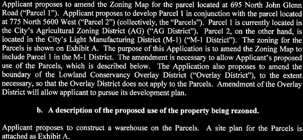
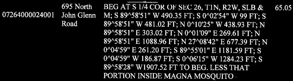
1 Staff Report PLANNING DIVISION COMMUNITY & ECONOMIC DEVELOPMENT To: Salt Lake City Planning Commission From: John Anderson, , Date: March 22, 2017 Re: PLNPCM John Glenn Road Zoning Map Amendments Zoning Map Amendments PROPERTY ADDRESS: 695 N. John Glenn Rd. PARCEL ID: MASTER PLAN: Northwest Quadrant ZONING DISTRICT: AG Agriculture and Lowland Conservancy Overlay District REQUEST: Seefried Development, representing the property owner Suburban Land Reserve Inc., is requesting to amend the zoning map on a property located at 695 N. John Glenn Road. The property is currently zoned AG Agriculture and is also located within the boundaries of the Lowland Conservancy Overlay District. The request is to change the zoning on the property to M-1 Light Manufacturing and to remove the property from the boundaries of the overlay district. The purpose of the amendment is to facilitate the future construction of a warehouse development on the property. RECOMMENDATION: Based on the information in this staff report, Planning Staff recommends that the Planning Commission forward a positive recommendation to the City Council for the proposed zoning map amendments. ATTACHMENTS: A. Vicinity Maps B. Property Photographs C. Additional Applicant Information D. Existing Conditions E. Analysis of Standards F. Public Process & Comments G. Department Review Comments PROJECT DESCRIPTION: The property owner is requesting to amend the zoning on a property in order to build a future industrial development at the site. The property is currently zoned AG Agriculture which does not allow for any industrial or commercial development. Permitted uses in the district are limited to agricultural and low density residential uses (a separate proposal, unrelated to this application, would remove residential uses from the AG zone). The applicant is further requesting to adjust the boundary of the SALT LAKE CITY CORPORATION 451 SOUTH STATE STREET, ROOM PO BOX SALT LAKE CITY, UT TEL FAX

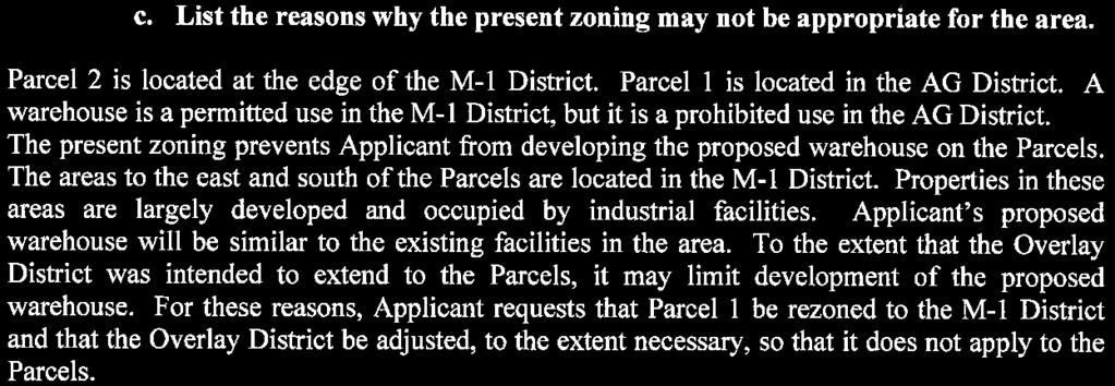
2 LC Lowland Conservancy Overlay District. Currently the boundary of the overlay district extends into this property affecting the north and northwest portions of the property. The overlay district does not allow for significant development in those affected areas. KEY ISSUES: The key issues listed below have been identified through the analysis of the project, neighbor and community input and department review comments. 1. Amending the Zoning Map from AG Agriculture to M-1 Light Manufacturing 2. Adjusting the Boundary of the LC Lowland Conservancy Overlay District Issue 1 Amending the Zoning Map from AG Agriculture to M-1 Light Manufacturing The current zoning of the property is AG Agriculture and has been since the property was annexed into the city as was much of the Northwest Quadrant. The zone only allows for limited low density residential development and agricultural uses. The AG District has been used by the city as a holding zone, waiting for a master plan to dictate the future development of the area. In 2016, the Northwest Quadrant Master Plan was adopted by the City Council. The image to the left is the future land use map for the Northwest Quadrant. The red circle indicates the approximate location of the property in question. As you can see the property is located in the area designated for Light Industrial uses. It is near the boundary of the Natural Area but does not extend into that area. The master plan states in the vision that this area should be, an economic engine for the City, region and State. To achieve the vision the plan states a number of goals including, Encourage a resilient and diversified economy and, Support quality jobs that including non-polluting and Page 2

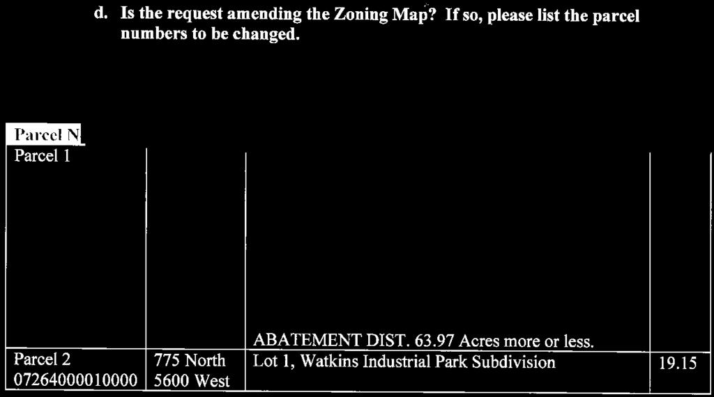
3 environmentally-conscious high-tech and manufacturing sectors. The master plan discusses that development should be conscious of the sensitive lands in the area and the protection of those areas located in the Natural Area. The M-1 District will allow the property owners to develop their property in a manner that has been determined as the appropriate use by the master plan. Staff are currently developing zoning standards for the M-1 zoned properties in the Northwest Quadrant to ensure that all new development is done in a manner that protects those sensitive and natural lands outlined in the plan. This may affect design features of future structures such as fencing and window placement and/or reflectivity. Issue 2 Adjusting the Boundary of the LC Lowland Conservancy Overlay District The property in question is outlined in red. The LC Lowland Conservancy Overlay District is the hatched area. If the proposal is approved the boundary would follow the existing north property lines and would not intrude onto the property in question. The applicant is also seeking to adjust the boundary of the LC Lowland Conservancy Overlay District. As shown in the image above it currently occupies areas along the north and northwest boundaries of the property. The proposal would be to remove the overlay entirely from the property in question. The purpose statement of the LC is: It is the purpose of this district to promote the public health, safety and general welfare of the present and future residents of the city and downstream drainage areas by providing for the protection, preservation, proper maintenance, and use of the city's watercourses, lakes, Page 3

4 ponds, floodplain and wetland areas. The requirements of this district shall supplement other applicable codes and regulations, including state and federal regulations and the Salt Lake City floodplain ordinance. The overlay district is intended to protect natural waterways and the plant and animal species that utilize them by limiting development in those areas. The overlay district generally allows for no development except limited activity related to agriculture and recreation. It was placed in this area of the Northwest Quadrant when the area was annexed into Salt Lake City. The city s Public Utilities Department has indicated that they are unsure as to the exact reason that the boundaries were placed in their current position, but it is clear that the boundary does not follow a specific elevation line and that it does include areas that do not fit the description of properties that the purpose statement outlines should be preserved. The Northwest Quadrant provides important habitat for migrating birds and other animal species. However, there are no ponds or other bodies of water on the property in question, the area is not located in the floodplain and there have been no wetland areas discovered in the area. Future development of the parcel would have to follow all federal and state regulations related to designated wetlands if identified in the future to determine the level of development that could occur on the entirety of the property. The map above shows the nearest area of the Great Salt Lake s floodplain outlined in blue. The property in question is noted in red. This property is clearly not located in or near the floodplain. DISCUSSION: The proposed zone change would facilitate a future industrial development on the property. The master plan s general policies and objectives for this area do support light industrial uses on the Page 4
5 property. Further, the LC overlay district is meant to protect specific natural areas which are not found on this property As such staff does recommend changing the zoning and modifying the boundary of the overlay district. NEXT STEPS: With a recommendation of approval or denial for the zoning amendment, the amendment proposal will be sent to the City Council for a final decision by that body. If the zoning amendment is approved, the property could be developed for any use allowed in the M-1 District on the property. Any development would need to be designed in accordance with all city standards. If the zoning amendment is denied, the property will remain zoned AG. With this zoning, the property could be developed as low density residential uses or be utilized as agricultural property. If the zoning on the property is changed but the overlay district is not removed from the property then future industrial development would only be allowed on those portions of the property that are not located in the overlay district. Page 5
6 1335 EAST ATTACHMENT A: ZONING AND FUTURE LAND USE MAPS Page 6

7 The red circle indicates the property in question.

8 The property in question is outlined in red. The current zoning on the property is AG Agriculture. Properties to the south and east are zoned as M-1 Light Manufacturing. The current boundaries of the LC Lowland Conservancy Overlay District are shown in hatching.
9 ATTACHMENT B: PROPERTY PHOTOGRAPHS Page 7


10 Photograph of the property looking towards the north.

11 Photograph of the property looking towards the northwest.

12 Photograph of the property looking towards the southwest.
13 ATTACHMENT C: APPLICANT S NARRATIVE Page 8
14
15
16 ATTACHMENT D: EXISTING CONDITIONS & ZONING STANDARDS Uses in the Immediate Vicinity of the Property East: Property is currently vacant/undeveloped and is located in the M-1 Light Manufacturing District. West: Property is currently vacant/undeveloped and is located in the AG Agriculture District. North: Property is currently vacant/undeveloped and is located in the AG Agriculture District. South: Property has been developed as light manufacturing. Page 9
17 ATTACHMENT E: ANALYSIS OF STANDARDS ZONING MAP AMENDMENTS 21A : A decision to amend the text of this title or the zoning map by general amendment is a matter committed to the legislative discretion of the city council and is not controlled by any one standard. In making a decision to amend the zoning map, the City Council should consider the following: Factor Finding Rationale 1. Whether a proposed map amendment is consistent with the purposes, goals, objectives, and policies of the city as stated through its various adopted planning documents; Complies Please see the discussion under Issues 1 and 2 regarding applicable master plan policies. As discussed, staff finds that the zoning amendment is consistent with objectives and policies of the Northwest Quadrant Master Plan and with the associated Future Land Use map. 2. Whether a proposed map amendment furthers the specific purpose statements of the zoning ordinance. Complies The M-1 purpose statement is as follows: The purpose of the M-1 light manufacturing district is to provide an environment for light industrial uses that produce no appreciable impact on adjacent properties and desire a clean attractive industrial setting. This zone is appropriate in locations that are supported by the applicable master plan policies adopted by the city. This district is intended to provide areas in the city that generate employment opportunities and to promote economic development. The uses include other types of land uses that support and provide service to manufacturing and industrial uses. Safe, convenient and inviting connections that provide access to businesses from public sidewalks, bike paths and streets are necessary and to be provided in an equal way. Certain land uses are prohibited in order to preserve land for manufacturing uses. The master plan has stated that this area of the city should be developed as Page 10
18 3. The extent to which a proposed map amendment will affect adjacent properties; No anticipated negative impacts due to the proposed map amendment if future development is designed correctly a light industrial use. As such, the location of the proposed zoning district does not conflict with the purpose statement of the zone. Properties to the south and east are currently developed as light industrial or vacant but zoned for the same uses. Properties to the west are designated in the master plan for light industrial uses as well. There should be no negative impacts to those properties as they could be developed in a similar fashion and light industrial uses should not produce negative impacts as noted in the purpose of the M-1 zoning district. The properties to the north are currently zoned as AG and the master plan has designated them to remain as a natural area. Light industrial uses generally have fewer negative impacts than other uses such as residential but it s important that any development in the future on the property takes the unique and sensitive nature of these natural areas into consideration. The master plan indicates the importance of protecting these natural areas and provides guidance on how that can be accomplished. Future development should take that guidance into consideration when designing their site and any future structures. Amendments to the M-1 zoning district which would codify those guiding principles is currently underway by staff. 4. Whether a proposed map amendment is consistent with the purposes and provisions of any applicable overlay zoning districts which may impose additional standards Complies Portions of the north and northwest areas of the property are located in the Lowland Conservancy Overlay District. The purpose statement of that overlay district is: It is the purpose of this district to promote the public health, safety and general welfare of the present and future residents of the city and downstream drainage areas by Page 11
19 5. The adequacy of public facilities and services intended to serve the subject property, including, but not limited to, roadways, parks and recreational facilities, police and fire protection, schools, stormwater drainage systems, water supplies, and wastewater and refuse collection. Complies providing for the protection, preservation, proper maintenance, and use of the city's watercourses, lakes, ponds, floodplain and wetland areas. The requirements of this district shall supplement other applicable codes and regulations, including state and federal regulations and the Salt Lake City floodplain ordinance. The primary goal of the overlay district is to protect existing watercourses and other sensitive lands. As there are no existing watercourses or wetlands on the property in questions staff believes that it is appropriate to adjust the boundary of the overlay district off of the property in question. This was discussed further in Issue 2 located on page 3 of this report. If the overlay district is removed from the property the proposal complies with this standard. The subject property is located on the edge of a built environment where public facilities and services already exist. Future development may require upgrading or extending utilities and drainage systems. However, such upgrades or extensions would be required through the building permit process when a specific development is proposed. No concerns were received from other City departments regarding the zoning map amendments. NOTES: Page 12
20 ATTACHMENT F: PUBLIC PROCESS & COMMENTS Public Notice, Meetings, Comments The following is a list of public meetings that have been held, and other public input opportunities, related to the proposed project: Notice of Application: A notice of application was mailed to the chairs of the West Pointe and Jordan Meadows Community Councils as the project is located near the boundary between each group. The Community Council was given 45 days to respond with any concerns. No comments were received from either community council. Open House: Because the property is located west of 2200 West the applicant was not required to attend a community council meeting. An open house was held on February 16, 2017 at the 10 th East Senior Center. Staff spoke with 2 nearby landowners about the proposal. Both supported the proposed zoning change and adjusting the boundary of the overlay district. Notice of the public hearing for the proposal included: Public hearing notice mailed on March 10, 2017 Public hearing notice posted on March 10, 2017 Public notice posted on City and State websites and Planning Division list serve on March 10, 2017 Public Input: There have been no public comments received as of staff report publication. Page 13
21 ATTACHMENT G: DEPARTMENT REVIEW COMMENTS Department Review Comments Engineering Scott Weiler or ) No objection to the proposed zoning amendment. Zoning Greg Mikolash or ) No zoning issues related to the proposed rezoning or the reconfiguration of the lowland conservancy district. Transportation Michael Barry or ) No comments received. Public Utilities Brad Stewart or ) I ve attached a map for reference showing the Husky property, Lowland Conservancy Overlay District, and elevation 4220 (NAVD88). To Public Utilities the 4220 (NAVD88) line is more important than the LLCO line. The preliminary designs for the NW Quadrant are being centered on the 4220 (NAVD88) as the minimum elevation necessary to minimize lake flooding and backwater effects. From the Husky drawings that we have seen it appears that Corbin Bennion, the Dominion Design Engineer, is designing the building, parking and maneuvering areas to all be above that elevation. It does somewhat appear that the original LLCO line was an approximation of the contours. My representation of the 4220 (NAVD88) line is from GIS 2 foot Lidar data. Public Utilities would support using the 4220 (NAVD88) line in lieu of the LLCO line for the Husky project. We also would not be opposed to minimal areas of fill to square-off the developable area for the project. Fire Ted Itchon (ted.itchon@slcgvoc.om or ) No comments. Page 14
PLNSUB Meridian Commerce Center Subdivision Amendment & PLNPCM Meridian Commerce Center Street Closure
 Staff Report PLANNING DIVISION COMMUNITY & ECONOMIC DEVELOPMENT To: From: Salt Lake City Planning Commission Daniel Echeverria, 801-535-7165, daniel.echeverria@slcgov.com Date: September 4, 2014 Re: PLNSUB2014-000469
Master Plan, Zoning Amendment and Preliminary Subdivision
 Staff Report PLANNING DIVISION COMMUNITY & ECONOMIC DEVELOPMENT To: From: Salt Lake City Planning Commission Doug Dansie, 801-535-6182, doug.dansie@slcgov.com Date: September 9, 2015 Re: PLNPCM2014-00254/00253
Business Park District Zoning Text Amendment (PLNPCM ) ZONING TEXT AMENDMENT
 ZONING TEXT AMENDMENT") Staff Report PLANNING DIVISION COMMUNITY & ECONOMIC DEVELOPMENT To: Salt Lake City Planning Commission From: Maryann Pickering, Principal Planner (801) 535-7660 Date: June 10, 2015 Re: Business Park District
Staff Report PLANNING DIVISION COMMUNITY & ECONOMIC DEVELOPMENT To: Salt Lake City Planning Commission From: Maryann Pickering, Principal Planner (801) 535-7660 Date: June 10, 2015 Re: Business Park District
PLANNING COMMISSION STAFF REPORT
 PLANNING COMMISSION STAFF REPORT West Capitol Hill Zoning Map Amendment Petition No. PLNPCM2011-00665 Located approximately at 548 W 300 North Street, 543 W 400 North Street, and 375 N 500 West Street
David J. Gellner, AICP, Principal Planner; (801) ; Zoning Map Amendment
 ; Zoning Map Amendment") Staff Report PLANNING DIVISION DEPARTMENT of COMMUNITY and NEIGHBORHOODS To: From: Salt Lake City Planning Commission David J. Gellner, AICP, Principal Planner; (801) 535-6107; david.gellner@slcgov.com
Staff Report PLANNING DIVISION DEPARTMENT of COMMUNITY and NEIGHBORHOODS To: From: Salt Lake City Planning Commission David J. Gellner, AICP, Principal Planner; (801) 535-6107; david.gellner@slcgov.com
Staff Report PLANNING DIVISION COMMUNITY & ECONOMIC DEVELOPMENT. Alley Closure
 Staff Report PLANNING DIVISION COMMUNITY & ECONOMIC DEVELOPMENT To: From: Salt Lake City Planning Commission Doug Dansie, 801-535-6182, doug.dansie@slcgov.com Date: March 23, 2016 Re: PLNPCM2015-00941
ADMINISTRATIVE HEARING STAFF REPORT
 ADMINISTRATIVE HEARING STAFF REPORT Nin Tech West II Subdivision Amendment PLNSUB2013-00980 1515 & 1555 South Gramercy Road February 13, 2014 Planning Division Department of Community & Economic Development
PLANNING COMMISSION REPORT Regular Agenda Public Hearing Item
 PC Staff Report 11/12/12 Item No. 2B- 1 PLANNING COMMISSION REPORT Regular Agenda Public Hearing Item ITEM NO. 2B: A TO GPI; 110 ACRES; E OF K-10 & N OF W 6 TH ST (MKM) : Consider a request to rezone approximately
PLANNING COMMISSION STAFF REPORT
 PLANNING COMMISSION STAFF REPORT West Capitol Hill Amendments PLNPCM2012-00462- Master Plan Amendments PLNPCM2012-00463- Zoning Map Amendments PLNPCM2012-00464- MU Mixed Use District Text Amendment Meeting
Request. Recommendation. Recommended Motion. Planning Division Department of Community and Economic Development
 PLANNING COMMISSION STAFF REPORT Legislative Item 900 South 900 East Rezone Zoning Map Amendment PLNPCM2010-00360 700 East 900 East, 700 South 900 South December 12, 2012 Applicant: City Council Luke Garrott
Planning Division Department of Community & Economic Development. Applicant: Volunteers of America: Kathy Bray
 Planning Commission Staff Report Volunteers of America Large Group Home Supportive Housing for Young Men Conditional Use PLNPCM2011-00485 556 South 500 East Hearing date: October 26, 2011 Planning Division
Staff Report. Street Vacation. Salt Lake City Planning Commission. Ashley Scarff, (801) or Date: April 10 th, 2019
 or Date: April 10 th, 2019") Staff Report PLANNING DIVISION DEPARTMENT of COMMUNITY & NEIGHBORHOODS To: From: Salt Lake City Planning Commission Ashley Scarff, (801) 535-7660 or ashley.scarff@slcgov.com Date: April 10 th, 2019 Re:
Staff Report PLANNING DIVISION DEPARTMENT of COMMUNITY & NEIGHBORHOODS To: From: Salt Lake City Planning Commission Ashley Scarff, (801) 535-7660 or ashley.scarff@slcgov.com Date: April 10 th, 2019 Re:
Staff Report: Date: Applicant: Property Identification: Acreage of Request: Current Zoning of Requested Area: Requested Action: Attached:
 Staff Report: Completed by Jeff Palmer Director of Planning & Zoning Date: November 7, 2018 Applicant: Greg Smith, Oberer Land Developer agent for Ronald Montgomery ET AL Property Identification: Frontage
PLANNING COMMISSION STAFF REPORT
 PLANNING COMMISSION STAFF REPORT ZONING MAP AMENDMENT PLNPCM2011-00091- Zoning Map Amendment PLNSUB2011-00090 Subdivision Amendment Approximately 700 North Columbus Court August 10, 2011 Planning and Zoning
PLNPCM : Attached Garage Regulations for Residential Districts ZONING TEXT AMENDMENT
 Staff Report PLANNING DIVISION COMMUNITY & ECONOMIC DEVELOPMENT To: From: Salt Lake City Planning Commission Daniel Echeverria (801) 535-7165 or daniel.echeverria@slcgov.com Date: September 3, 2015 Re:
ARLINGTON COUNTY, VIRGINIA. County Board Agenda Item Meeting of September 19, 2015
 ARLINGTON COUNTY, VIRGINIA County Board Agenda Item Meeting of September 19, 2015 DATE: August 28, 2015 SUBJECT: Request to authorize advertisement of public hearings by the Planning Commission and the
Staff Report: Date: Applicant: Property Identification: Acreage of Request: Current Zoning of Requested Area: Requested Action: Attached:
 Staff Report: Completed by Jeff Palmer Director of Planning & Zoning Date: November 7, 2018, Updated November 20, 2018 Applicant: Greg Smith, Oberer Land Developer agent for Ronald Montgomery ET AL Property
DRAFT FOR PUBLIC HEARING (rev. March, 2016)
") Chapter 200. ZONING Article VI. Conservation/Cluster Subdivisions 200-45. Intent and Purpose These provisions are intended to: A. Guide the future growth and development of the community consistent with
Chapter 200. ZONING Article VI. Conservation/Cluster Subdivisions 200-45. Intent and Purpose These provisions are intended to: A. Guide the future growth and development of the community consistent with
Legal Description Part of the Western Half of the Eastern Half of the Northwest Quarter of Section 30, Le Ray Township
 Owner and Applicant s 20448 State Highway 83 Mankato, MN 56001 Request and Location Request for review and approval of a Conditional Use Permit to allow an Elder Care Residential Unit to be constructed
Surplus Property Exchange
 Staff Report PLANNING DIVISION COMMUNITY & ECONOMIC DEVELOPMENT To: From: Salt Lake City Planning Commission Chris Lee, 801-535-7706, christopher.lee@slcgov.com Date: February 18, 2016 Re: PLNPCM2016-00049,
Planned Unit Development (PUD). Sections:
. Sections:") Chapter 19.07. Planned Unit Development (PUD). Sections: 19.07.01. Purpose. 19.07.02. PUD Definition and Design Compatibility. 19.07.03. General PUD Standards. 19.07.04. Underlying Zones. 19.07.05. Permitted
Chapter 19.07. Planned Unit Development (PUD). Sections: 19.07.01. Purpose. 19.07.02. PUD Definition and Design Compatibility. 19.07.03. General PUD Standards. 19.07.04. Underlying Zones. 19.07.05. Permitted
Draft Model Access Management Overlay Ordinance
 Draft Model Access Management Overlay Ordinance This model was developed using the City of Hutchinson and the Trunk Highway 7 corridor. The basic provisions of this model may be adopted by any jurisdiction
Chapter 22 PLANNED UNIT DEVELOPMENT.
 Chapter 22 PLANNED UNIT DEVELOPMENT. Sec. 22.1 INTENT. The use of land and the construction and use of buildings and other structures as Planned Unit Developments in Georgetown Township may be established
(if more than one, give square footage for each) ANNEXATION LOT LINE Adjustments PRE/FINAL PLAT SPECIAL USE PERMIT
 ANNEXATION LOT LINE Adjustments PRE/FINAL PLAT SPECIAL USE PERMIT") Planning Commission Application Building & development office 915 Third ST. Rawlins WY ph. 307-328-4599 fax. 307-328-4590 PROJECT REVIEW: GENERAL INFORMATION Project name: OFFICE USE ONLY Site address
Planning Commission Application Building & development office 915 Third ST. Rawlins WY ph. 307-328-4599 fax. 307-328-4590 PROJECT REVIEW: GENERAL INFORMATION Project name: OFFICE USE ONLY Site address
O-I (Office-Institutional) and AG-1(Agricultural)
 and AG-1(Agricultural)") PROPERTY INFORMATION ADDRESS 3503 and 3505 Bethany Bend DISTRICT, LAND LOTS 2/1 973 and 974 OVERLAY DISTRICT State Route 9 PETITION NUMBERS EXISTING ZONING O-I (Office-Institutional) and AG-1(Agricultural)
PROPERTY INFORMATION ADDRESS 3503 and 3505 Bethany Bend DISTRICT, LAND LOTS 2/1 973 and 974 OVERLAY DISTRICT State Route 9 PETITION NUMBERS EXISTING ZONING O-I (Office-Institutional) and AG-1(Agricultural)
RECOMMENDATION REPORT
 SARPY COUNTY PLANNING & BUILDING DEPARTMENT RECOMMENDATION REPORT CHANGE OF ZONE (CZ 18-005) PRELIMINARY PLAT (PP 18-007) FINAL PLAT (FP 18-008) SCHOLTING ESTATES APPLICANT: DIANE SCHOLTING PLANNING COMMISSION
Administrative Hearing Officer, Salt Lake City Planning Division. Conditional Use for the Salt Flats Brewery Club/Tasting Room (PLNPCM )
") Staff Report PLANNING DIVISION DEPARTMENT of COMMUNITY and NEIGHBORHOODS To: From: Administrative Hearing Officer, Salt Lake City Planning Division David J. Gellner, AICP, Principal Planner (801) 535-6107
Staff Report PLANNING DIVISION DEPARTMENT of COMMUNITY and NEIGHBORHOODS To: From: Administrative Hearing Officer, Salt Lake City Planning Division David J. Gellner, AICP, Principal Planner (801) 535-6107
Understanding the Conditional Use Process
 Understanding the Conditional Use Process The purpose of this document is to explain the process of applying for and obtaining a conditional use permit in the rural unincorporated towns of Dane County.
MASTER PLAN AMENDMENT ALLEY VACATION LOT CONSOLIDATION
 Staff Report PLANNING DIVISION COMMUNITY & ECONOMIC DEVELOPMENT To: Salt Lake City Planning Commission From: John Anderson; 801-535-7214 Date: April 27, 2016 Re: PLNPCM2016-00094, 00095, 00096 and PLNSUB2016-00114
Staff Recommendation Denial. Staff Planner Jonathan Sanders
 Applicant Traditional Concepts, LLC & Victory Baptist Church of Virginia Beach, Inc. Property Owner Victory Baptist Church Public Hearing January 9, 2019 City Council Election District Princess Anne Agenda
Planning Commission Application Summary
 Planning Commission Application Summary Project Name: Creekside Estates Zone Change and Land Use Amendment Address: 571 West 11400 South Current Zoning: RA1 Hearing Date: July 14, 2016 Summary of Request
FINDINGS OF FACT. Page 1 of 8
 FINDINGS OF FACT The City/County Planning staff has prepared the Findings of Fact for the Emerald View Park Subdivision, Amended Lot 1A, Block 3. These findings are based on the preliminary plat application
REQUEST STAFF RECOMMENDATION. On April 26, 2012, Signature Books Inc., represented by Dave Richards, submitted petitions for the following amendments:
 PLANNING COMMISSION STAFF REPORT Signature Books Zoning Map Amendment and an Amendment to the North Temple Area Plan Petitions PLNPCM2012-00254 PLNPCM2012-00255 July 11, 2012 Planning Division Department
Planning Commission Application Summary
 Planning Commission Application Summary Project Name: Ballard Property Rezone Address: 12773 & 12775 South 300 East, 415 East Pheasant View Dr. Current Zoning: RA1 (Residential 40,000 sq. ft. minimum)
Planning and Zoning Division Department of Community Development. Applicant: Ivory Towns LLC
 ADMINISTRATIVE HEARING STAFF REPORT Trolley Place Condominiums New Preliminary Condominium 480-08-08 located at approximately 540 South Denver Street July 7, 2008 Planning and Zoning Division Department
SUBDIVISION, PLANNED UNIT DEVELOPMENT, ZONING AMENDMENT, & SIDEWALK WAIVER STAFF REPORT Date: July 19, 2018
 SUBDIVISION, PLANNED UNIT DEVELOPMENT, ZONING AMENDMENT, & SIDEWALK WAIVER STAFF REPORT Date: July 19, 2018 NAME SUBDIVISION NAME LOCATION West Mobile Properties, LLC U.S. Machine Subdivision 556, 566,
PLANNED UNIT DEVELOPMENT & SUBDIVISION STAFF REPORT Date: April 18, 2019
 PLANNED UNIT DEVELOPMENT & SUBDIVISION STAFF REPORT Date: April 18, 2019 DEVELOPMENT NAME SUBDIVISION NAME Springhill Village Subdivision Springhill Village Subdivision LOCATION 4350, 4354, 4356, 4358,
ZONING AMENDMENT & SUBDIVISION STAFF REPORT Date: July 3, 2014
 ZONING AMENDMENT & SUBDIVISION STAFF REPORT Date: July 3, 2014 APPLICANT NAME SUBDIVISION NAME LOCATION Georgia Crown Distributing Subdivision Georgia Crown Distributing Subdivision Southwest corner of
PLANNING COMMISSION STAFF REPORT
 PLANNING COMMISSION STAFF REPORT A1 Auto Parts Conditional Use Outdoor Auto Salvage and Recycling in M-1 PLNPCM2010-00188 5 South 5100 West June 23, 2010 Applicant: Mike Vanikiotis Staff: Katia Pace, 535-6354,
CHAPTER 10 Planned Unit Development Zoning Districts
 CHAPTER 10 Planned Unit Development Zoning Districts Section 10.1 Intent and Purpose The Planned Unit Development (PUD) districts are intended to offer design flexibility for projects that further the
PLANNING COMMISSION STAFF REPORT. QUEST ASSISTED LIVING CONDITIONAL USE PLNPCM West 800 North Hearing date: October 14, 2009
 PLANNING COMMISSION STAFF REPORT QUEST ASSISTED LIVING CONDITIONAL USE PLNPCM2009-00971 1820 West 800 North Hearing date: October 14, 2009 Planning Division Department of Community & Economic Development
Charter Township of Plymouth Zoning Ordinance No. 99 Page 208 Article 21: Residential Unit Developments Amendments: ARTICLE XXI
 Charter Township of Plymouth Zoning Ordinance No. 99 Page 208 ARTICLE XXI RESIDENTIAL UNIT DEVELOPMENTS PURPOSE The purpose of the Residential Unit Development (RUD) is to permit two (2) optional methods
ARTICLE FIVE FINAL DRAFT
 ARTICLE FIVE 021218 FINAL DRAFT Sec. 503.6 Open Space Preservation Option Open Space Preservation Option Open Space Preservation developments may be approved in the AR, R-1, R-2 and R-3 zoning districts,
Town of Norwich, Vermont SUBDIVISION REGULATIONS
 Town of Norwich, Vermont SUBDIVISION REGULATIONS Adopted: August 6, 2002 Amended: February 8, 2006 Prepared by Norwich Planning Commission with the assistance of: Burnt Rock Inc. A ssociates in Community
Residential Major Subdivision Review Checklist
 Residential Major Subdivision Review Checklist Plan Submittal Requirements: 2 full sets of stamped plans Electric submittal - all plans contained in a single PDF 3 full sets if commercial kitchen or dining
Industrial Road Cross Dock Subdivision Minor Subdivision Preliminary Plat PLNSUB South Industrial Road Hearing date: May 9, 2013
 ADMINISTRATIVE HEARING STAFF REPORT Industrial Road Cross Dock Subdivision Minor Subdivision Preliminary Plat PLNSUB2013-00158 1900 South Industrial Road Hearing date: May 9, 2013 Applicant: Corbin Bennion
Planning Division Department of Community & Economic Development. Applicant: Peter and Sandra Clark
 Planning Commission Staff Report Peter and Sandra Clark Special Exception-Unit Legalization Special Exception PLNPCM2013-00336 2551 S Highland Drive Public Hearing: September 25, 2013 Planning Division
SUBJECT: Application for Planned Unit Development and Rezoning 1725 Winnetka Road
 TO: FROM: CHAIRMAN BILL VASELOPULOS AND MEMBERS OF THE PLAN & ZONING COMMISSION STEVE GUTIERREZ DIRECTOR OF COMMUNITY DEVELOPMENT MEETING DATE: September 5, 2017 SUBJECT: Application for Planned Unit Development
HOMER TOWNSHIP PLANNING COMMISSION LAND USE APPLICATION
 LAND USE APPLICATION 1-APPLICATION FOR: (check all that apply) Site plan Rezoning-regular PUD Special use Rezoning-spot Subdivision Rezoning-conditional 2-APPLICANT/PARCEL INFORMATION - Applicant is property
HOW TO APPLY FOR A USE PERMIT
 HOW TO APPLY FOR A USE PERMIT MENDOCINO COUNTY PLANNING AND BUILDING SERVICES What is the purpose of a use permit? Throughout the County, people use their properties in many different ways. They build
Title 6 - Local Government Provisions Applicable to Special Purpose Districts and Other Political Subdivisions
 Title 6 - Local Government Provisions Applicable to Special Purpose Districts and Other Political Subdivisions CHAPTER 29. SOUTH CAROLINA LOCAL GOVERNMENT COMPREHENSIVE PLANNING ENABLING ACT OF 1994 1994
PLANNING COMMISSION STAFF REPORT. Salt Lake City Code Maintenance Land Use Tables and Definitions PLNPCM September 26, 2012.
 PLANNING COMMISSION STAFF REPORT Salt Lake City Code Maintenance Land Use Tables and Definitions PLNPCM2009-00169 September 26, 2012 Applicant: Mayor Ralph Becker Staff: Lex Traughber (801) 535-6184 Lex.Traughber@slcgov.com
PLANNING FOR OUR FUTURE
 PLANNING FOR OUR FUTURE ELLSWORTH TOWNSHIP LAND USE AND POLICY PLAN The purpose of this Plan is to serve as a guide for the Township Trustees, Zoning Commission, Board of Zoning Appeals, developers, employers,
Allow continued use of existing grass runway for personal use by landowner.
 CUP-13-00193 Item No. 4-1 PLANNING COMMISSION REPORT Regular Agenda PC Staff Report 7/22/13 ITEM NO. 4: CONDITIONAL USE PERMIT; PRIVATE LANDING STRIP; 2215 N 500 (MKM) CUP-13-00193: Consider a Conditional
MIDWAY CITY Municipal Code
 MIDWAY CITY Municipal Code TITLE 9 ANNEXATION CHAPTER 9.01 PURPOSE CHAPTER 9.02 GENERAL REQUIREMENTS CHAPTER 9.03 PROPERTY OWNER INITIATION OF ANNEXATION CHAPTER 9.04 PROCEDURES FOR CONSIDERATION OF PETITION
Reading Plats and the Complexities of Antiquated Subdivisions Presented by: David W. Depew, PhD, AICP, LEED AP Morris-Depew Associates, Inc.
 Presented by: David W. Depew, PhD, AICP, LEED AP Morris-Depew Associates, Inc. Introduction Plat is a term for a survey of a piece of land to identify boundaries, easements, flood zones, roadway, and access
Chapter Planned Residential Development Overlay
 Chapter 19.29 Planned Residential Development Overlay Sections 010 Purpose 020 Scope 030 Definitions 030 Minimum Size 040 Allowable Uses 050 Minimum Development Standards 060 Density Bonus 070 Open Space
Planned Residence District (PR) To review a plan to construct 11 single family homes on approximately 4.01 acres.
 To review a plan to construct 11 single family homes on approximately 4.01 acres.") STAFF REPORT PLANNING & ZONING COMMISSION Village Green Municipal Building, Council Chambers 47 Hall Street Wednesday, March 13, 2019 7:00 P.M. 1. FINAL DEVELOPMENT PLAN REVIEW Applicant: Romanelli and
STAFF REPORT PLANNING & ZONING COMMISSION Village Green Municipal Building, Council Chambers 47 Hall Street Wednesday, March 13, 2019 7:00 P.M. 1. FINAL DEVELOPMENT PLAN REVIEW Applicant: Romanelli and
Town of Bristol Rhode Island
 Town of Bristol Rhode Island Subdivision & Development Review Regulations Adopted by the Planning Board September 27, 1995 (March 2017) Formatted: Highlight Formatted: Font: 12 pt Table of Contents TABLE
AAAA. Planning and Zoning Staff Report Lake Shore Land Holdings, LLC CU-PH Analysis
 AAAA Planning and Zoning Staff Report Lake Shore Land Holdings, LLC CU-PH2016-28 Hearing Date: April 21, 2016 Development Services Department Applicant: BRS Architects/Cindy Huebert Staff: Kyle McCormick,
UPPER MOUNT BETHEL TOWNSHIP NORTHAMPTON COUNTY, PENNSYLVANIA
 UPPER MOUNT BETHEL TOWNSHIP NORTHAMPTON COUNTY, PENNSYLVANIA JOINDER DEED / LOT CONSOLIDATION TOWNSHIP REVIEW PROCESS When accepting proposed Joinder Deeds / Lot Consolidations, review the Joinder Deed
The Corporation of the District of Central Saanich
 The Corporation of the District of Central Saanich COMMITTEE OF THE WHOLE REPORT For the Committee of the Whole meeting on November 28, 2016 To: Patrick Robins Chief Administrative Officer File: From:
PLANNING COMMISSION STAFF REPORT. Merrimac PLNSUB Planned Development 38 West Merrimac November 9, Request. Staff Recommendation
 PLANNING COMMISSION STAFF REPORT Merrimac PLNSUB2011-00374 Planned Development 38 West Merrimac November 9, 2011 Planning and Zoning Division Department of Community and Economic Development Applicant:
DEPARTMENT OF PLANNING & ZONING COMPREHENSIVE PLANNING LAND PRESERVATION FOREST CONSERVATION GIS
 DEPARTMENT OF PLANNING & ZONING COMPREHENSIVE PLANNING LAND PRESERVATION FOREST CONSERVATION GIS September 8, 2017 Case #: RZ-17-005 Application for Map Amendment Staff Report and Analysis Property Owner(s)
Town of Cary, North Carolina Rezoning Staff Report 14-REZ-24 Indian Wells Road Properties Town Council Meeting November 20, 2014
 Town of Cary, North Carolina Rezoning Staff Report 14-REZ-24 Indian Wells Road Properties Town Council Meeting November 20, 2014 REQUEST To amend the Town of Cary Official Zoning Map by revising a condition
CHAPTER 3 PERMITS, PLANS AND ANNEXATION
 CHAPTER 3 PERMITS, PLANS AND ANNEXATION SECTION: 10-3-1: General Regulations 10-3-2: Building Permit 10-3-3: Plans 10-3-4: Certificate of Compliance and Occupancy 10-3-5: Conditional Use Permits 10-3-6:
Application for Conditional Use Permit CITY OF VALDOSTA PLANNING AND ZONING DIVISION
 Application for Conditional Use Permit CITY OF VALDOSTA PLANNING AND ZONING DIVISION This is an application for approval of a Conditional Use as listed in the Table of Uses of the Valdosta Land Development
ADMINISTRATIVE HEARING STAFF REPORT Country Club Acres Second Amended Subdivision Amendment PLNSUB E Parkway Avenue December 12, 2013
 ADMINISTRATIVE HEARING STAFF REPORT Country Club Acres Second Amended Subdivision Amendment PLNSUB2013-00925 2167 E Parkway Avenue December 12, 2013 Planning Division Department of Community & Economic
 PROJECT NARRATIVE AVENIR PCD MISCELLANEOUS AMENDMENT November 27, 2018 Urban Planning and Design Landscape Architecture Communication Graphics Request Avenir Development, LLC and Avenir Holdings, LLC,
City and County of Broomfield, Colorado
 City and County of Broomfield, Colorado CITY COUNCIL AGENDA MEMORANDUM To: From: Mayor and City Council George Di Ciero, City and County Manager Teri Malies, Principal Planner Terrance Ware, Planning Director
TOWN OF ORO VALLEY PLANNING & ZONING COMMISSION MEETING DATE: December 6, 2011
 PLANNING & ZONING COMMISSION MEETING DATE: December 6, 2011 TO: FROM: SUBJECT: PLANNING & ZONING COMMISSION Matt Michels, Senior Planner mmichels@orovalleyaz.gov; tel. 229-4822 Public Hearing: Rancho de
ARTICLE XXI GENERAL SITE DEVELOPMENT PLAN REQUIREMENTS
 1 2 3 4 5 6 7 8 9 10 11 12 13 14 15 16 17 18 19 20 21 22 23 24 25 ARTICLE XXI GENERAL SITE DEVELOPMENT PLAN REQUIREMENTS Section 21.1 Purpose and Intent... 2 Section 21.2 Administrative Site Plan Review
ADMINISTRATIVE REPORT
 ADMINISTRATIVE REPORT TO: FROM: Advisory Planning Commission B. Newell, Chief Administrative Officer DATE: February 14, 2017 RE: OCP & Zoning Bylaw Amendment Electoral Area D Purpose: To facilitate a residential
PLANNING COMMISSION REPORT Regular Agenda Public Hearing Item
 PC Staff Report 10/21/2013 Item No. 3B - 1 PC Staff Report 10/21/2013 ITEM NO. 3B: PLANNING COMMISSION REPORT Regular Agenda Public Hearing Item A TO CR- FP; 8.4 ACRES; 1900 W. 31 st STREET (SLD) : Consider
HERON LANDING SUBDIVISION
 HERON LANDING SUBDIVISION Engineering Comments: Per FEMA guidelines, any development greater than 5 acres in size or subdivision 50 lots in size, requires a flood study. Width of drainage easement to be
TOOELE COUNTY LAND USE ORDINANCE CHAPTER 31 Page 1
 CHAPTER 31 PLANNED COMMUNITY ZONE (P-C) Section 31-1 Definitions. 31-2 Purpose. 31-3 Land use districts. 31-4 P-C zone area minimum requirements. 31-5 Permitted uses. 31-6 Conditional uses. 31-7 Planning
CLEARFIELD CITY COUNCIL AGENDA AND SUMMARY REPORT July 31, 2018 SPECIAL POLICY SESSION
 CLEARFIELD CITY COUNCIL AGENDA AND SUMMARY REPORT July 31, 2018 SPECIAL POLICY SESSION Meetings of the City Council of Clearfield City may be conducted via electronic means pursuant to Utah Code Ann. 52-4-207
ZONING ORDINANCE: OPEN SPACE COMMUNITY. Hamburg Township, MI
 ZONING ORDINANCE: OPEN SPACE COMMUNITY Hamburg Township, MI ARTICLE 14.00 OPEN SPACE COMMUNITY (Adopted 1/16/92) Section 14.1. Intent It is the intent of this Article to offer an alternative to traditional
Guide to Replats. Step 1. Step 2. Step 3. Step 4. Step 5. Step 6. Step 7. Step 8. Step 9. Step 10
 Guide to Replats Introduction Douglas County is committed to providing open, transparent application processes to the public. This Guide is provided to assist anyone interested in the procedures and expectations
COMPREHENSIVE PLAN FUTURE LAND USE MAP AMENDMENT APPLICATION
 COUNTY STAFF DATA ONLY Date Received: Project No. CPA-20 - GADSDEN COUNTY DEPARTMENT OF PLANNING & COMMUNITY DEVELOPMENT 1-B East Jefferson Street, Post Office Box 1799, Quincy, FL 32353-1799 PLANNING
PLANNING DIVISION DEPARTMENT OF COMMUNITY AND NEIGHBORHOODS. Conditional Use
 Staff Report PLANNING DIVISION DEPARTMENT OF COMMUNITY AND NEIGHBORHOODS To: From: Salt Lake City Planning Commission Maryann Pickering, Principal Planner (801) 535-7660 Date: July 27, 2016 Re: Church
Chapter 100 Planned Unit Development in Corvallis Urban Fringe
 100.100 Scope and Purpose. Chapter 100 Planned Unit Development in Corvallis Urban Fringe (1) All applications for land divisions in the Urban Residential (UR) and Flood Plain Agriculture (FPA) zones within
Medical Marijuana Special Exception Use Information
 Medical Marijuana Special Exception Use Information The Special Exception Use information below is a modified version of the Unified Development Code. It clarifies the current section 5:104 Special Exceptions
PLANNING COMMISSION REPORT Regular Agenda Public Hearing Item
 CUP-15-00474 Item No. 5-1 PC Staff Report 11/16/15 ITEM NO. 5 PLANNING COMMISSION REPORT Regular Agenda Public Hearing Item CONDITIONAL USE PERMIT FOR PUBLIC WHOLESALE WATER SUPPLY DISTRICT NO. 25; E 1300
MASTER SUBDIVISION FINAL PLAT APPLICATION Town of Apex, North Carolina
 MASTER SUBDIVISION FINAL PLAT APPLICATION Town of Apex, North Carolina This document is a public record under the North Carolina Public Records Act and may be published to the Town s website or disclosed
Project File #: VA Project Name: Beauperthuy Variance Parcel Nos.: , , , ,
 COMMISSIONERS: DARRYL GLENN (PRESIDENT) MARK WALLER (PRESIDENT PRO TEMPORE) STAN VANDERWERF LONGINOS GONZALEZ PEGGY LITTLETON PLANNING AND COMMUNITY DEVELOPMENT DEPARTMENT CRAIG DOSSEY, EXECUTIVE DIRECTOR
LABEL PLEASE NOTE: ALL APPLICATIONS AND SITE PLANS MUST BE COMPLETED IN BLACK OR BLUE INK ONLY Intake by:
 STAFF USE ONLY Thurston County Resource Stewardship 2000 Lakeridge Dr. S.W. Olympia, WA 98502 (360)786-5490 / (360)754-2939 (Fax) TDD Line (360) 754-2933 Email: permit@co.thurston.wa.us Supplemental Application
ZONING MAP CHANGE (REZONING) & ZONING TEXT AMENDMENT APPLICATION AND REVIEW PROCESS
 & ZONING TEXT AMENDMENT APPLICATION AND REVIEW PROCESS") COMMUNITY DEVELOPMENT ZONING MAP CHANGE (REZONING) & ZONING TEXT AMENDMENT APPLICATION AND REVIEW PROCESS Overview: Zoning Change applications will be reviewed by City staff and discussed in a public hearing
COMMUNITY DEVELOPMENT ZONING MAP CHANGE (REZONING) & ZONING TEXT AMENDMENT APPLICATION AND REVIEW PROCESS Overview: Zoning Change applications will be reviewed by City staff and discussed in a public hearing
COMMUNITY DEVELOPMENT DEPARTMENT 333 Broadalbin Street SW, P.O. Box 490 Albany, OR 97321
 COMMUNITY DEVELOPMENT DEPARTMENT 333 Broadalbin Street SW, P.O. Box 490 Albany, OR 97321 Ph: 541-917-7550 Fax: 541-917-7598 www.cityofalbany.net STAFF REPORT Application for Site Plan Review SP-07-18 and
PLANNING DIVISION COMMUNITY & NEIGHBORHOODS. Conditional Use
 Staff Report PLANNING DIVISION COMMUNITY & NEIGHBORHOODS To: Salt Lake City Administrative Hearing Officer From: John Anderson, 801-535-7214 Date: March 22, 2018 Re: PLNPCM2018-00037 Conditional Use for
Section SKETCH PLAN REVIEW
 Section 210 - SKETCH PLAN REVIEW 1. Within 30 days of receiving a complete application for a subdivision involving three or more lots, the Zoning Administrator shall refer the matter to the first available
Town of Cumberland Town Council Neighborhood Meeting Notice Monday, December 12, 2016 at 5:30 P.M. Town Council Chambers
 Town of Cumberland Town Council Neighborhood Meeting Notice Monday, December 12, 2016 at 5:30 P.M. Town Council Chambers The Cumberland Town Council invites you to a neighborhood meeting on Monday, December
Residential Minor Subdivision Review Checklist
 Residential Minor Subdivision Review Checklist Plan Submittal Requirements: 2 full sets of stamped plans Electric submittal - all plans contained in a single PDF 3 full sets if commercial kitchen or dining
PART 1: PROJECT SUMMARY
 PART 1: PROJECT SUMMARY R18-04: Walden Major Revision Staff Analysis Petition R18-04 Walden Conditional District Rezoning Revision to revise Phases 3, 6, & 8 and add 6.16-acres of land (new Phase 9). Applicant:
8/17/16 PC Meeting 1
 1 GENERAL INFORMATION OWNER/APPLICANT: Thomas Corff & Terry Moberly (1943 13 th St.) 19328 Towercrest Dr. Oregon City, OR 97045 Michael & Jill Parker (1983 13 th St.) 1708 Oak St. Lake Oswego, OR 97034
Land Use. Land Use Categories. Chart 5.1. Nepeuskun Existing Land Use Inventory. Overview
 Land Use State Comprehensive Planning Requirements for this Chapter A compilation of objectives, policies, goals, maps and programs to guide the future development and redevelopment of public and private
SITE DEVELOPMENT PLAN REQUIREMENTS CHECKLIST
 SITE DEVELOPMENT PLAN REQUIREMENTS CHECKLIST Completed DRC Application for Review Required for Application Process DRC Processing Fee 1 Commercial $2,500.00 Fire Department Review Fee 150.00 Total $2,650.00
ZRTD , Glenn Drive. M. Tyler Klein, AICP, Project Manager, Planning and Zoning John Merrithew, Acting Director, Planning and Zoning
 DEPARTMENT OF PLANNING Date of Hearing: AND ZONING STAFF REPORT # 4 BOARD OF SUPERVISORS PUBLIC HEARING SUBJECT: ELECTION DISTRICT: ZRTD-2014-0003, 22675 Glenn Drive Broad Run CRITICAL ACTION DATE: September
North Qu Appelle No. 187 Bylaw Basic Planning Statement - Table of Contents
 - Table of Contents Section1 Introduction 2 Section 2 - The Rural Municipality of North Qu Appelle No. 187 3 Section 3 Municipal Goals.... 3 Section 4 Agriculture and Natural Resources.. 4 Section 5 Residential
PLANNING COMMISSION STAFF REPORT
 PLANNING COMMISSION STAFF REPORT Century Link Conditional Use for Two Utility Boxes in the Public Right-of-Way Case # PLNPCM2013-00317 700 E Northcrest Drive July 11, 2013 Planning Division Department