1. Action taken on the Planning & Zoning Commission items by City Council at the February 27, 2018, regular meeting.
|
|
|
- MargaretMargaret Bond
- 5 years ago
- Views:
Transcription

1 AGENDA CITY OF ALLEN PLANNING AND ZONING COMMISSION REGULAR MEETING TUESDAY, MARCH 6, :00 P.M. CITY COUNCIL CHAMBERS ALLEN CITY HALL 305 CENTURY PARKWAY ALLEN, TEXAS Call to Order and Announce a Quorum is Present Pledge of Allegiance Directors Report 1. Action taken on the Planning & Zoning Commission items by City Council at the February 27, 2018, regular meeting. Consent Agenda (Routine P&Z business. Consent Agenda is approved by a single majority vote. Items may be removed for open discussion by a request from a Commission member or member of staff.) 2. Approve minutes from the February 20, 2018, regular meeting. 3. Final Plat Consider a request for a Final Plat for Cottonwood Creek Addition, Lots 1 & 2, Block A, being ± acres located in the Seaborn & Clements Survey, Abstract No. 879, and all of Cottonwood Creek Baptist Church Addition, Lot 1, Block A; generally located south of State Highway 121 and west of Watters Road. (PL ) [Allen Harley Davidson] 4. Final Plat Consider a request for a Final Plat for Ridgeview Crossing Phase 1A, being ± acres located in the F. Dasser Survey, Abstract No. 280 and the G. Phillips Survey, Abstract No. 701; generally located west of Chelsea Boulevard and south of the Ridgeview Drive right-of-way. (PL ) [Ridgeview Crossing Phase 1A] 5. Final Plat Consider a request for a Final Plat for Ridgeview Crossing Phase 1B, being ± acres located in the F. Dasser Survey, Abstract No. 280; generally located west of Chelsea Boulevard and south of the Ridgeview Drive right-of-way. (PL ) [Ridgeview Crossing Phase 1B] Regular Agenda 6. Public Hearing Conduct a Public Hearing and consider a request for a Replat for Lyrick Addition, Lots 1-AR, 2R, 3R, and 4-7, Block A, being ± acres; generally located south of Bethany Drive and west of Greenville Avenue. (PL ) [Lyrick Addition] 305 CENTURY PARKWAY ALLEN, TEXAS WEB: coa@cityofallen.org
2 7. Discuss proposed amendments to the Allen Land Development Code. Executive Session (As Needed) As authorized by Section (2) of the Texas Government Code, this meeting may be convened into closed Executive Session for the purpose of seeking confidential legal advice from the City Attorney on any agenda item listed herein. Adjournment This notice was posted at Allen City Hall, 305 Century Parkway, Allen, Texas, at a place convenient and readily accessible to the public at all times. Said notice was posted on Friday, March 2, 2018, at 5:00 pm. Shelley B. George, City Secretary Allen City Hall is wheelchair accessible. Access to the building and special parking are available at the entrance facing Century Parkway. Requests for sign interpreters or special services must be received forty-eight (48) hours prior to the meeting time by calling the City Secretary at
3 Director s Report from 2/27/2018 City Council Meeting No items were taken to the February 27, 2018 City Council Regular Meeting.
4 PLANNING AND ZONING COMMISSION REGULAR MEETING FEBRUARY 20, 2018 ATTENDANCE: Commissioners Present: Ben Trahan, Chair Michael Orr, 2 nd Vice-Chair Gene Autrey Dan Metevier Commissioners Absent: Stephen Platt, Jr., 1 st Vice-Chair John Ogrizovich City Staff Present: Madhuri Mohan, AICP, Senior Planner Hayley Angel, Planner Nicole Corr, City Attorney Call to Order and Announce a Quorum is Present: With a quorum of the Commissioners present, Chairman Trahan called the meeting to order at 7:00 p.m. in the City Hall Council Chambers Room at Allen City Hall, 305 Century Parkway, Allen, Texas, Directors Report 1. The Senior Planner discussed the action taken on the Planning & Zoning Commission items by City Council at the February 13, 2018, regular meeting. Consent Agenda (Routine P&Z business: Consent Agenda is approved by a single majority vote. Items may be removed for open discussion by a request from a Commission member or member of staff.) 2. Approve minutes from the February 6, 2018, workshop meeting and the February 6, 2018, regular meeting. 3. Capital Improvement Program (CIP) Status Report. 4. Final Plat Consider a request for a Final Plat for McCoy and Roth Addition, Lot 4AR, Block A, being 1.380± acres located in the J. Miller Survey, Abstract No. 609 and all of McCoy and Roth Addition, Lot 4A, Block A; generally located east of Angel Parkway and south of Stacy Road. (PL ) [McCoy and Roth Addition]. Motion: Upon a motion by Commissioner Metevier, and a second by Commissioner Autrey, the Commission voted 4 IN FAVOR, and 0 OPPOSED to approve the Consent Agenda. The motion carried.
5 Planning and Zoning Commission February 20, 2018 Page 2 Regular Agenda 5. Preliminary Plat Consider a request for a Preliminary Plat for The Enclave, being ± acres located in the John Huffman Survey, Abstract No. 416; generally located north of Hedgcoxe Road and east of Custer Road. (PL-Pre ) [The Enclave] Ms. Angel, Planner, presented the item to the Commission. Ms. Angel stated that the Preliminary Plat is consistent with the Concept Plan and meets the requirements of the Allen Land Development Code. She noted that staff is in support of the agenda item. Motion: Upon a motion by Commissioner Autrey, and a second by 2 nd Vice-Chair Orr, the Commission voted 4 IN FAVOR, and 0 OPPOSED to approve the Preliminary Plat for The Enclave, generally located north of Hedgcoxe Road and east of Custer Road. The motion carried. Executive Session (As Needed) The Executive Session was not held. Adjournment The meeting adjourned at 7:04 p.m. These minutes approved this day of Ben Trahan, Chairman Hayley Angel, Planner
6 PLANNING & ZONING COMMISSION AGENDA COMMUNICATION AGENDA DATE: March 6, 2018 SUBJECT: STAFF RESOURCE: Consider a request for a Final Plat for Cottonwood Creek Addition, Lots 1 & 2, Block A, being ± acres located in the Seaborn & Clements Survey, Abstract No. 879, and all of Cottonwood Creek Baptist Church Addition, Lot 1, Block A; generally located south of State Highway 121 and west of Watters Road. (PL ) [Allen Harley Davidson] Hayley Angel Planner PREVIOUS COMMISSION/COUNCIL Planned Development No. 40 Approved October, 1986 ACTION: SUP No. 88 Approved September, 2001 Preliminary Plat Approved December, 2001 Final Plat Approved March, 2002 Planned Development No. 40 Amended December, 2017 Preliminary Plat Approved January, 2018 LEGAL NOTICES: ANTICIPATED COUNCIL DATE: None. None. BACKGROUND The property is generally located south of State Highway 121 and west of Watters Road. The property to the north (across SH 121) is the City of McKinney. The properties to the west and east are zoned Planned Development PD No. 40 Corridor Commercial CC. The property to the south is zoned Planned Development PD No. 72 Corridor Commercial CC. A Concept Plan for a Motor Cycle Sales and Service use (Harley Davidson) was approved in December 2017, and a Preliminary Plat was approved in January A Site Plan is currently under review. Final platting is the last step in the development process. The Final Plat shows approximately ± acres being subdivided into two lots. There are four points of access into the development; three on State Highway 121 and one on Ridgeview Drive. The plat also shows various easements required for development. The Final Plat has been reviewed by the Technical Review Committee, is generally consistent with the Concept Plan and Preliminary Plat, and meets the requirements of the Allen Land Development Code. STAFF RECOMMENDATION Staff recommends approval. MOTION I make a motion to approve the Final Plat for Cottonwood Creek Addition, Lots 1 & 2, Block A; generally located south of State Highway 121 and west of Watters Road.
7 Planning & Zoning Commission March 6, 2018 Allen Harley Davidson Page 2 ATTACHMENTS Final Plat
8 N S E W ' (TRACT LINE) ' ' L48 (ABANDONED ) N01 04'11"W ' (BASIS OF BEARINGS) S 01 04'11" E 1, S01 04'11"E ' 25' BUILDING LINE ' CC # ' 51.33' (ABANDONED ) CC # ' BUILDING LINE N89 22'13"E ' ' L20 N89 33'06"E L21 S89 22'13"W ' S89 33'06"W ' L22 Scale 1" = 60' VICINITY MAP NOT TO SCALE FLOOD STUDY INFORMATION Information regarding the proposed floodplain location, the minimum finish floor elevation, the public drainage easement, and the drainage maintenance easement are based upon the SH 121 & Stacy Road Flood Study prepared by Winkelmann & Associates, Inc. dated December 6, /2" CIRS 15' WATERLINE 35' DRAINAGE 1/2" IRF NAD 83 GRID VALUES N=7,102, E=2,523, ' DRAINAGE 24' FIRE LANE & WATERLINE 15' SANITARY SEWER J. SEABORN & R. T. CLEMENTS SURVEY ABSTRACT A0879 TRACT 4 WATERLINE 10' SANITARY SEWER CC # ' LANDSCAPE 15' WATER 15' WATERLINE CC # (ABANDONED ) () 10' PEDESTRIAN C49 ACCESS LOT 2 () ACRES ' (520,257 SQ. FT.) MINIMUM FINISH 15' WATER FLOOR ELEVATION= FIRELANE, ACCESS & () UTILITY () FIRELANE, ACCESS & UTILITY () L36 15' FLOODPLAIN MAINTENANCE () L62 COTTONWOOD CREEK ADDITION LOTS 1 & 2, BLOCK A 1/2" CIRS ACRES (2,390,494 SQ. FT.) 1/2" CIRS 15' FLOODPLAIN MAINTENANCE PUBLIC DRAINAGE FLOODPLAIN () CC # (ABANDONED BY 1/2" CIRS () THIS PLAT) LOT ACRES (1,870,234 SQ. FT.) 1/2" CIRS N 47 57'53" W 1/2" CIRS 48.02' 1/2" CIRS 24' FIRE LANE & 24' FIRE LANE & WATERLINE WATERLINE CABINET 2016, PAGE ' WATER LINE VOLUME 5070, PAGE 4270 TxDOT BMON CM 1/2" CIRF "5439" SANITARY SEWER CC # ' SANITARY SEWER () 1/2" CIRS 15' SANITARY SEWER VOLUME 5070, PAGE 4256 POINT OF BEGINNING 5/8" CIRF "TNP" CM (CC # ) 1/2" CIRS N 70 12'03" E ' L4 L47 L46 L ' S49 37'35"E 53.39' N38 28'11"W L44 L43 L42 L41 L ' ' N 64 36'18" E L39 N25 45'01"W ' N86 50'41"E ' (ABANDONED ) CC # ' BUILDING LINE 61.21' S39 32'52"E N79 10'08"E ' L38 N 25 23'43" W ' N 64 36'19" E ' N 69 10'45" E ' L1 L2 N 82 42'26" W ' N 56 13'14" W ' ' N 68 18'59" W S 86 07'25" W ' N 78 44'01" W ' S 85 51'36" W ' FIRE LANE & WATERLINE MATCH LINE ~ SEE SHEET 2 24' FIRE LANE & Δ=77 42'27" WATERLINE R=234.50' CC # L=318.04' CL=294.22' CB=N51 46'36"W 24' FIRE LANE & WATERLINE CABINET 2016, PAGE ' 30' DRAINAGE L3 L73 L37 S76 05'25"E 98.86' N71 08'16"W N83 17'18"E ' 45.98' S70 56'56"W ' S70 23'42"E ' S64 14'59"W ' N40 30'36"W ' L35 S70 23'42"E ' S69 10'45"W ' N79 15'27"W 58.76' S28 02'06"E 82.86' S25 23'42"E ' N25 23'42"W ' S46 52'23"E ' N25 23'42"W ' ' S80 42'05"E N89 22'13"E 44.71' ' N79 06'00"E ' N87 01'00"E L18 S75 35'24"E N69 44'54"E 49.41' L19 L17 S84 18'55"E ' N64 36'18"E 71.34' N88 57'10"E ' C29 C28 S64 36'18"W S88 57'10"W ' 81.34' N84 18'55"W ' C ' S58 43'26"E C34 L64 15' WATER () FLOOD PLAIN () 15' FLOODPLAIN MAINTENANCE () 15' FLOODPLAIN MAINTENANCE () 29.76' C39 C ' 24.0' L50 L49 L67 S25 23'42"E ' N25 23'42"W ' L ' 31.06' 90.90' 18.29' L69 NAD 83 GRID VALUES N=7,103, E=2,524, SEABORN & CLEMENTS SURVEY, ABSTRACT NO. 879 CITY OF ALLEN COLLIN COUNTY, TEXAS COYOTE MOTORSPORTS LAND MANAGEMENT-ALLEN, LTD EAST CAMELBACK RD PHOENIX, ARIZONA '± 269'± ' S59 09'40"E ' ' 83.50' (VARIABLE WIDTH RIGHT-OF-WAY) STATE HWY ' C47L56 L54 C48 C45 L57 L53C46 L52 L61 L ' 18.03' C41 C42 N64 36'18"E ' S25 23'42"E ' N25 23'42"W ' S64 36'18"W ' C43 C ' C31 C32 C35 L25 L24 C25 L26 C24 C27 L23 L58 L59 L60 L65 L66 206'± 31.86' 264'± 60.50' L63 L68 10' PEDESTRIAN ACCESS () 10' PEDESTRIAN ACCESS () S64 36'18"W ' S64 36'18"W ' 90.00' 26.0' 26.0' 253'± 25' BUILDING LINE ALLEN ECONOMIC DEVELOPMENT CORPORATION CC # FLOOD NOTE According to the Federal Emergency Management Agency, Flood Insurance Rate Map Community Panel No C0270J, dated June 2, 2009, this property is within Flood Zone X. Zone X - Areas determined to be outside the 0.2% annual chance floodplain. This flood statement does not imply that the property and/or the structure thereon will be free from flooding or flood damage. On rare occasions, greater floods can and will occur and flood heights may be increased by man-made or natural causes. This flood statement shall not create liability on the part of the surveyor. WINES FAMILY IRREVOCABLE TRUST ET AL J. SEABORN & R. T. CLEMENTS SURVEY TRACT 3 Date : Scale : 1" = 60' File : FPLT Project No. : FINAL PLAT COTTONWOOD CREEK ADDITION LOTS 1 & 2, BLOCK A No. DATE REVISION Texas Engineers Registration No. 89 Texas Surveyors No Expires 12/31/2018 COPYRIGHT 2018, Winkelmann & Associates, Inc. G:\731\01\SURVEY\Plats\73101-FPLT.dwg N WATTERS RD STATE HWY 121 (SAM RAYBURN TOLLWAY) SITE 0' 30' 60' 120' RIDGEVIEW DR STACY RD 79.75' 49.84' C ' S77 23'09"E SURVEYOR OWNER OWNER Winkelmann & Assoc. Coyote Motorsports Land Cottonwood Creek Baptist Church 6750 Hillcrest Plaza Drive Management-Allen, Ltd Sam Rayburn Tollway Suite East Camelback Rd Allen, Texas Dallas, Texas Phoenix, Arizona ph NOTE: THE BASIS FOR SURVEY IS STATE PLANE 4202 PER THE ALDC. FINAL PLAT COTTONWOOD CREEK ADDITION LOTS 1 & 2, BLOCK A BEING ACRES (2,390,494 SQ. FT.) OUT OF THE SEABORN & CLEMENTS SURVEY, ABSTRACT NO. 879, AND BEING ALL OF LOT 1, BLOCK A, COTTONWOOD CREEK BAPTIST CHURCH ADDITION, IN THE CITY OF ALLEN, COLLIN COUNTY, TEXAS
9 L16 L14 N01 02'50"W ' N 01 02'49" W 1, ' BUILDING LINE; CC # (ABANDONED ) CC # (TRACT LINE) ' S01 02'50"E ' S01 02'50"E ' S01 02'50"E ' 24.0' (ABANDONED ) 25' BUILDING LINE S00 37'47"E ' N00 37'47"W ' 90.87' 25' BUILDING LINE CC # (ABANDONED ) 24.0' N00 37'47"W 69.43' 92.65' 53.92' 30' DRAINAGE 24' FIRE LANE & WATERLINE COTTONWOOD CREEK ADDITION LOTS 1 & 2, BLOCK A ACRES (2,390,494 SQ. FT.) LOT ACRES (1,870,234 SQ. FT.) COTTONWOOD CREEK CHURCH PROPERTIES, INC. CC # TRACT 14 J. SEABORN & R. T. CLEMENTS SURVEY ABSTRACT A0879 FIRE LANE & WATERLINE UNDEFINED CABINET 2016, PAGE 317 CC # ' WATERLINE L29 C33 L27 L28 Texas Engineers Registration No. 89 Texas Surveyors No Expires 12/31/2018 COPYRIGHT 2018, Winkelmann & Associates, Inc. G:\731\01\SURVEY\Plats\73101-FPLT.dwg N S25 23'42"E ' ' 20.5' WATERLINE 24' FIRE LANE & WATERLINE CABINET 2016, PAGE 317 N25 23'42"W ' No. DATE REVISION E W N25 23'37"W ' S 24' FIRE LANE & WATERLINE 75' MUTUAL ACCESS & UTILITY 5/8" CIRF "TNP" CM (CC # ) 120 WINES FAMILY IRREVOCABLE TRUST ET AL J. SEABORN & R. T. CLEMENTS SURVEY TRACT 3 C36 L30 C38 C37 L31 S25 23'42"E ' N25 23'42"W ' C ' N64 36'18"E C12 S64 36'18"W 52.00' C ' S25 23'42"E C9 C5 N25 23'42"W 94.70' 94.70' S25 23'42"E 44.00' N64 36'15"E N25 23'42"W 94.70' S64 36'18"W ' S64 36'18"W ' 70.72' N64 36'18"E C4 C ' C10 C11 C13 L33 L32 L34 C14 N64 36'18"E ' N64 36'18"E ' C15 C16 C17 C18 C3 C2 120'± L5 S56 41'44"E ' S 33 18'05" W L ' N56 41'44"W ' N56 41'44"W ' ' S56 41'44"E ' RIGHT-OF-WAY DEED CITY OF ALLEN RIDGEVIEW DRIVE PARCEL ROW-1 VOLUME 5070, PAGE ' N56 41'44"W C ' S 89 22'14" W 1, '± 60'± NAD 83 GRID VALUES N=7,101, E=2,524, (120' RIGHT-OF-WAY) RIDGEVIEW DR. L15 L12 L13 C19 L11 C20 C21 L7 L8 L9 L10 C23 C22 ALLEN ECONOMIC DEVELOPMENT CORPORATION CC # J. SEABORN & R. T. CLEMENTS SURVEY ABSTRACT A0879 TRACT 4 NAD 83 GRID VALUES N=7,101, E=2,523, SITE VICINITY MAP NOT TO SCALE MATCH LINE ~ SEE SHEET 1 SURVEYOR Winkelmann & Assoc Hillcrest Plaza Drive Suite 325 Dallas, Texas ph OWNER Coyote Motorsports Land Management-Allen, Ltd East Camelback Rd Phoenix, Arizona ' OWNER Cottonwood Creek Baptist Church 1015 Sam Rayburn Tollway Allen, Texas ' FIRE LANE & WATERLINE 12.63' 60 Scale 1" = 60' 24.0' 24.0' 24.0' 24.0' 24.0' 24.0' 24.0' FINAL PLAT COTTONWOOD CREEK ADDITION LOTS 1 & 2, BLOCK A SEABORN & CLEMENTS SURVEY, ABSTRACT NO. 879 CITY OF ALLEN COLLIN COUNTY, TEXAS COYOTE MOTORSPORTS LAND MANAGEMENT-ALLEN, LTD EAST CAMELBACK RD PHOENIX, ARIZONA ' 24.0' Date : Scale : File : Project No. : " = 60' FPLT FINAL PLAT COTTONWOOD CREEK ADDITION LOTS 1 & 2, BLOCK A BEING ACRES (2,390,494 SQ. FT.) OUT OF THE SEABORN & CLEMENTS SURVEY, ABSTRACT NO. 879, AND BEING ALL OF LOT 1, BLOCK A, COTTONWOOD CREEK BAPTIST CHURCH ADDITION, IN THE CITY OF ALLEN, COLLIN COUNTY, TEXAS 24.0' N WATTERS RD STATE HWY 121 (SAM RAYBURN TOLLWAY) RIDGEVIEW DR STACY RD
10 G:\731\01\SURVEY\Plats\73101-FPLT.dwg CURVE TABLE CURVE TABLE NO. DELTA RADIUS LENGTH CH. L CH. B NO. DELTA RADIUS LENGTH C1 4 38'30" 1,025.69' 83.09' 83.07' S35 37'20"W C '29" ' ' C '28" 84.00' 82.18' 78.95' S28 39'54"E C '29" ' ' C '28" 60.00' 58.70' 56.39' S28 39'54"E C '59" 30.00' 55.21' C '29" 30.00' 60.10' 50.54' N58 00'41"W C '52" 30.00' 34.15' C '52" 53.98' 23.33' 23.15' N13 00'25"W C '52" 54.00' 61.48' C '35" 30.00' 47.13' 42.43' N19 36'18"E C '48" 30.00' 13.99' C '58" 30.00' 47.11' 42.42' S70 23'55"E C '52" 30.00' 34.15' C '56" 50.00' 78.54' 70.71' N70 23'42"W C '25" 54.00' 23.49' C '56" 50.00' 78.54' 70.71' S19 36'18"W C '41" 44.00' 50.09' C '58" 30.00' 47.11' 42.42' N19 36'05"E C '37" 20.00' 22.77' C '56" 30.00' 47.12' 42.43' N19 36'16"E C '04" 30.00' 38.49' C '56" 26.00' 40.84' 36.77' N70 23'42"W C '17" 54.00' 69.26' C '56" 26.00' 40.84' 36.77' S19 36'18"W C '47" 30.05' 45.94' C '04" 30.00' 47.12' 42.43' S70 23'44"E C '14" ' 69.16' C '01" ' ' ' S84 06'11"E C '54" ' 71.58' C '01" ' ' ' S84 06'11"E C '00" 30.00' 47.12' C '04" ' ' ' S84 06'11"E C '00" 56.00' 87.96' C '10" ' ' ' S84 06'08"E C '00" 30.00' 47.12' C '52" ' ' ' S26 55'41"E C '52" 56.00' 87.96' C '52" ' ' ' S26 55'41"E C '03" ' 31.00' C '08" ' 77.56' 76.99' S40 44'00"E C '03" 99.72' 23.85' C '49" ' ' ' S26 55'43"E C '10" ' 23.86' C '28" ' 73.62' 73.13' S12 30'33"E C '10" ' 31.01' C '56" ' ' ' S44 09'40"W C '05" 30.00' 7.99' C '05" ' ' ' S39 30'15"W CH. L ' ' 47.74' 32.34' 58.21' 13.86' 32.34' 23.31' 47.43' 21.56' 35.90' 64.61' 41.59' 68.26' 70.07' 42.43' 79.20' 42.43' 79.20' 30.93' 23.79' 23.80' 30.94' 7.97' CH. B S30 36'52"W S30 36'52"W N27 19'48"E S58 00'55"E N58 00'45"W N77 16'23"W N58 00'45"W S12 55'59"E N58 00'44"W N58 00'37"W N11 20'59"E S11 20'59"W S20 53'24"W N41 22'19"W N45 54'09"W N19 36'18"E N19 36'18"E S70 23'42"E S70 23'42"E N32 12'57"W N32 12'41"W S32 13'47"E SURVEYOR OWNER S32 13'47"E Winkelmann & Assoc. Coyote Motorsports Land 6750 Hillcrest Plaza Drive Management-Allen, Ltd. N33 01'44"W Suite East Camelback Rd Dallas, Texas Phoenix, Arizona ph LINE TABLE LINE # BEARING DISTANCE L1 N59 47'49"E 39.32' L2 N64 36'19"E 40.27' L3 N25 23'42"W 12.00' L4 N64 39'12"E 25.10' L5 S56 41'44"E 50.00' L6 N33 18'16"E 75.00' L7 S52 48'36"E 50.91' L8 S52 48'36"E 50.91' L9 S52 48'36"E 50.91' L10 S52 48'36"E 50.90' L11 S59 18'01"W 45.35' L12 S30 41'59"E 15.00' L13 N59 18'01"E 44.20' L14 S88 57'10"W 45.38' L15 S01 02'50"E 15.00' L16 N88 57'10"E 45.38' L17 S25 23'42"E 25.37' L18 N64 36'18"E 10.00' L19 N25 23'42"W 10.37' L20 N89 22'13"E 59.82' L21 N89 22'13"E 93.21' L22 N00 28'17"W 45.01' L23 N64 36'23"E 52.41' L24 S25 23'42"E 99.98' L25 N25 23'42"W 43.50' L26 N64 36'18"E 40.49' L27 N25 23'42"W 56.48' L28 S64 36'28"W 64.49' L29 N64 36'23"E 21.13' L30 S64 43'35"W 30.06' L31 N25 23'42"W 44.90' L32 S25 23'42"E 50.67' L33 N64 36'18"E 15.00' L34 N25 23'42"W 50.67' L35 S13 44'19"E 96.09' L36 N39 27'37"W 75.50' LINE # L37 L38 L39 L40 L41 L42 L43 L44 L45 L46 L47 L48 L49 L50 L51 L52 L53 L54 L55 L56 L57 L58 L59 L60 L61 L62 L63 L64 L65 L66 L67 L68 L69 L73 LINE TABLE BEARING DISTANCE SEABORN & CLEMENTS SURVEY, ABSTRACT NO. 879 CITY OF ALLEN COLLIN COUNTY, TEXAS COYOTE MOTORSPORTS LAND MANAGEMENT-ALLEN, LTD EAST CAMELBACK RD PHOENIX, ARIZONA No. DATE REVISION Texas Engineers Registration No. 89 Texas Surveyors No Expires 12/31/2018 COPYRIGHT 2018, Winkelmann & Associates, Inc. OWNERS CERTIFICATE STATE OF TEXAS COUNTY OF COLLIN WHEREAS, We, Coyote Motorsports Land Management-Allen, Ltd. and Cottonwood Creek Baptist Church, are the sole owners of a tract of land situated in the SEABORN & CLEMENTS SURVEY, ABSTRACT NO. 879, in the City of Allen, Collin County, Texas, and being all of Lot 1, Block A, Cottonwood Creek Baptist Church Addition, an addition to the City of Allen, Collin County, Texas, according to the plat thereof recorded in County Clerk's Instrument No , Official Public Records, Collin County, Texas, and being a portion of the same tract of land as described in deed to Cottonwood Creek Church Properties, Inc., recorded in County Clerk's Instrument No , Official Public Records, Collin County, Texas, and being more particularly described as follows: BEGINNING at a 5/8-inch iron rod with a plastic cap stamped "TNP" {controlling monument; County Clerk's Instrument No } found for corner on the Southerly right-of-way of State Highway 121, a variable width right-of-way, said point being the Northeast corner of said Cottonwood Creek Church Properties tract; THENCE South 01 deg 04 min 11 sec East, (Basis of Bearing) departing the Southerly right-of-way of said State Highway 121 and along the east line of said Cottonwood Creek Church Properties, Inc., a distance of 1, feet to a 5/8-inch iron rod with a plastic cap stamped "TNP" found for corner {controlling monument; County Clerk's Instrument No }, said iron rod being situated in the northwesterly right-of-way line of Ridgeview Drive (120' right-of-way); THENCE South 33 deg 18 min 05 sec West, departing the east line and along a southeast line of said Cottonwood Creek Church Properties, Inc. and said northwesterly right-of-way line, a distance of feet to a 1/2-inch iron rod with red plastic cap stamped "WAI" set for corner and the beginning of a curve to the right having a radius of 1, feet, a central angle of 04 deg 38 min 30 sec, a chord bearing of South 35 deg 37 min 20 sec West and a chord length of feet; THENCE continuing along said southeast line and said northwesterly right-of-way line and along said curve to the right, an arc distance of feet to a 1/2-inch iron rod with red plastic cap stamped "WAI" set for corner, said iron rod being the the most southerly southeast corner of said Cottonwood Creek Church Properties, Inc.; THENCE South 89 deg 22 min 14 sec West, departing the southeast line and along the south line of said Cottonwood Creek Church Properties, Inc., and along the south line of said Lot 1, Block A, a distance of 1, feet to a 1/2-inch iron rod with red plastic cap stamped "WAI" set for corner, said iron rod being the southwest corner of said Lot 1, Block A; THENCE North 01 deg 02 min 49 sec West, departing the south line and along the west line of said Lot 1, Block A, a distance of 1, feet to a 5/8-inch iron rod with a plastic cap stamped "Pacheco" found for corner {controlling monument; County Clerk's Instrument No }, said iron rod being situated in the Southerly right-of-way line of said State Highway 121; THENCE departing the west line and along the northerly line of said Lot 1, Block A and along the Southerly right-of-way line of said State Highway 121, the following: North 59 deg 47 min 49 sec East, a distance of feet to a 1/2-inch iron rod found for corner; North 64 deg 36 min 19 sec East, a distance of feet to a 1/2-inch iron rod with red plastic cap stamped "WAI" set for corner; North 69 deg 10 min 45 sec East, a distance of feet to a 1/2-inch iron rod with red plastic cap stamped "WAI" set for corner; THENCE North 64 deg 36 min 19 sec East, a distance of feet to a 1/2-inch iron rod with red plastic cap stamped "WAI" set for corner; THENCE North 25 deg 23 min 42 sec West, a distance of feet to a 1/2-inch iron rod with red plastic cap stamped "WAI" set for corner; THENCE North 64 deg 36 min 18 sec East, a distance of feet to a 1/2-inch iron rod with a plastic cap stamped 5439 found for the Northeast corner of said Lot 1, Block A and the Northwest corner of said Cottonwood Creek Church Properties tract; THENCE North 64 deg 39 min 12 sec East, continuing along the Southerly right-of-way of said State Highway 121 and along the Northerly line of said Cottonwood Creek Church Properties tract, a distance of feet to a TXDOT (Texas Department of Transportation) brass monument found for corner; THENCE North 70 deg 12 min 03 sec East, continuing along the Southerly right-of-way of said State Highway 121 and the Northerly line of said Cottonwood Creek Church Properties tract, a distance of feet to the POINT OF BEGINNING. CONTAINING within these metes and bounds acres or 2,390,494 square feet of land, more or less. Bearings shown hereon are based upon an on-the-ground Survey performed in the field on the 19th day of April 2017, utilizing a G.P.S. bearing related to the Texas Coordinate System, North Texas Central Zone (4202), NAD 83, grid values. KNOW ALL MEN BY THESE PRESENTS: That Coyote Motorsports Land Management-Allen, Ltd. and Cottonwood Creek Baptist Church, through the undersigned authority, does hereby adopt this plat designating the described property as "COTTONWOOD CREEK ADDITION", Lots 1 & 2, Block A, an addition to the City of Allen, Texas, and does hereby dedicate to the public use forever the streets and alleys thereon; and does hereby dedicate the easement strips shown on the plat for mutual use and accommodation of all public utilities desiring to use, or using same. No buildings, fences, trees, shrubs or other improvements shall be constructed or placed upon, over or across the easement strips on said plat. Any public utility shall have the right to remove and keep removed all or part of any buildings, fences, trees, shrubs, or other improvements, or growths which in any way endanger or interfere with the construction, maintenance or efficiency of its respective system on any of these easement strips, and any public utility shall at all times have the right of ingress and egress to and from and upon any of said easement strips for the purpose of construction, reconstruction, inspecting, patrolling, maintaining and adding to or removing all or part of its respective system without the necessity at any time of procuring the permission of anyone. This plat is approved subject to all platting ordinances, rules, regulations, and resolutions of the City of Allen, Texas. Witness my hand this day of, By: Coyote Motorsports Land Management-Allen, Ltd. By: William Coultier Title STATE OF COUNTY OF BEFORE ME, the undersigned, a Notary Public in and for said County and State on this day personally appeared William Coultier, known to me to be the person and officer whose name is subscribed to the foregoing instrument and acknowledged to me that the same was the act of the said Coyote Motorsports Land Management-Allen, Ltd. and that he executed the same as the act of such Coyote Motorsports Land Management-Allen, Ltd. for the purpose and consideration therein expressed, and in the capacity therein stated. GIVEN UNDER MY HAND AND SEAL OF OFFICE day of, Notary Public in and for State of My Commission Expires: Witness my hand this day of, By: Cottonwood Creek Baptist Church By: Scott Sanford Title STATE OF TEXAS COUNTY OF COLLIN BEFORE ME, the undersigned, a Notary Public in and for said County and State on this day personally appeared Scott Sanford, known to me to be the person and officer whose name is subscribed to the foregoing instrument and acknowledged to me that the same was the act of the said Cottonwood Creek Baptist Church and that he executed the same as the act of such Cottonwood Creek Baptist Church for the purpose and consideration therein expressed, and in the capacity therein stated. GIVEN UNDER MY HAND AND SEAL OF OFFICE day of, Notary Public in and for State of Texas My Commission Expires: SURVEYORS CERTIFICATE I, Leonard J. Lueker, do hereby certify that I prepared this plat from an actual and accurate survey of the land and that the corner monuments shown thereon shall be properly placed, under my personal supervision, in accordance with the subdivision regulations of the City of Allen, Texas. PRELIMINARY, this document shall not be recorded for any purpose and shall not be used or viewed or relied upon as a final survey document. Leonard J. Lueker Registered Professional Land Surveyor Texas Registration No Winkelmann & Associates, Inc Hillcrest Plaza Drive, Suite 325 Dallas, Texas (972) STATE OF TEXAS COUNTY OF DALLAS BEFORE ME, the undersigned, a Notary Public in and for said County and State, on this day personally appeared Leonard J. Lueker, known to me to be the person whose name is subscribed to the foregoing instrument and acknowledged to me that he executed the same for the purposes and considerations therein. WITNESS MY HAND AND SEAL OF OFFICE THIS THE DAY OF, Notary Public in and for the State of Texas Approved Attest Chairman Secretary Planning and Zoning Commission Planning and Zoning Commission Date Date Executed Pro-forma Mayor Date The undersigned, the City Secretary of the City of Allen, Texas, hereby certifies that the foregoing Final Plat of the "COTTONWOOD CREEK ADDITION", Lots 1 & 2, Block A, to the City of Allen was submitted to the Planning and Zoning Commission and approved by it on the day of, City Secretary, City of Allen OWNER Cottonwood Creek Baptist Church 1015 Sam Rayburn Tollway Allen, Texas N25 45'01"W N64 14'59"E N10 57'06"E N35 24'08"E N19 19'12"W N21 38'49"E N10 14'00"W N19 57'54"E N31 12'55"W N60 17'38"W S83 31'28"E N88 55'49"E S28 19'50"E S25 23'42"E N22 55'03"W N25 23'42"W N39 03'51"W N25 23'42"W S25 23'42"E S39 03'51"E S25 23'42"E N64 36'18"E S25 23'42"E S64 36'18"W S17 59'08"E N25 23'42"W 24.38' 20.17' 22.28' 20.29' 30.29' 34.11' 19.24' 16.32' 31.66' 19.49' 17.94' 15.00' 39.05' 49.35' 46.14' 22.50' 7.85' 15.63' 23.53' 7.85' 22.50' 23.42' 15.00' 25.31' 46.48' 9.50' FINAL PLAT COTTONWOOD CREEK ADDITION LOTS 1 & 2, BLOCK A S64 36'18"W S25 23'42"E S64 36'08"W N25 23'52"W N64 36'08"E S64 36'18"W S45 50'43"W N15 35'59"E 15.00' 9.50' 11.26' 15.00' 11.26' 19.76' 31.09' 11.55' Date : Scale : File : Project No. : FINAL PLAT COTTONWOOD CREEK ADDITION LOTS 1 & 2, BLOCK A BEING ACRES (2,390,494 SQ. FT.) OUT OF THE SEABORN & CLEMENTS SURVEY, ABSTRACT NO. 879, AND BEING ALL OF LOT 1, BLOCK A, COTTONWOOD CREEK BAPTIST CHURCH ADDITION, IN THE CITY OF ALLEN, COLLIN COUNTY, TEXAS
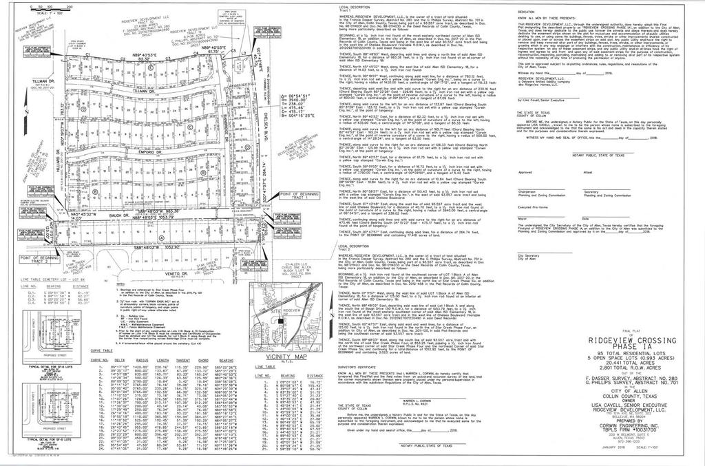
11 PLANNING & ZONING COMMISSION AGENDA COMMUNICATION AGENDA DATE: March 6, 2018 SUBJECT: STAFF RESOURCE: Consider a request for a Final Plat for Ridgeview Crossing Phase 1A, being ± acres located in the F. Dasser Survey, Abstract No. 280 and the G. Phillips Survey, Abstract No. 701; generally located west of Chelsea Boulevard and south of the Ridgeview Drive right-of-way. (PL ) [Ridgeview Crossing Phase 1A] Hayley Angel Planner PREVIOUS COMMISSION/COUNCIL Alternative Screening Request Approved June, 2016 ACTION: General Development Plan Approved July, 2016 Planned Development No. 130 Approved June, 2017 Preliminary Plat Approved September, 2017 Planned Development No. 130 Amended January, 2018 LEGAL NOTICES: ANTICIPATED COUNCIL DATE: None. None. BACKGROUND The property is generally located west of Chelsea Boulevard and south of the Ridgeview Drive right-of-way. The property to the north is zoned Planned Development PD No. 130 Single-Family Residential R-6. The property to the east (across Chelsea Boulevard) is zoned Agricultural Open Space AO. The properties to the south are zoned Planned Development PD No. 92 Single-Family Residential R-7 and Planned Development PD No. 92 Single-Family Residential R-5. The properties to the west (across Hillard Drive) are zoned Planned Development PD No. 130 Single-Family Residential R-5 and Agricultural Open Space AO. The property is zoned Planned Development PD No. 130 Single-Family Residential R-6 and Planned Development PD No. 130 Single-Family Residential R-5. A Planned Development was approved by City Council in June 2017, and a Planned Development Amendment addressing the elevations was approved by City Council in January A Preliminary Plat was approved in September The Final Plat is the last step in the development process. The Preliminary Plat showed two phases of development. The subject Final Plat is for a portion of Phase 1, and shows ± acres of land subdivided into 95 residential lots and 5 Open Space/HOA lots. There are five points of access into this portion of the development; the primary access point is on Chelsea Boulevard and the other four are through internal drives. The plat also shows the various easements and right-of-way dedication required for development of the property. The Final Plat has been reviewed by the Technical Review Committee, is generally consistent with the PD Concept Plan and the Preliminary Plat, and meets the requirements of the Allen Land Development Code. STAFF RECOMMENDATION Staff recommends approval.
12 Planning & Zoning Commission March 6, 2018 Ridgeview Crossing Phase 1A Page 2 MOTION I make a motion to approve the Final Plat for Ridgeview Crossing 1A; generally located west of Chelsea Boulevard and south of the Ridgeview Drive right-of-way. ATTACHMENTS Final Plat
13
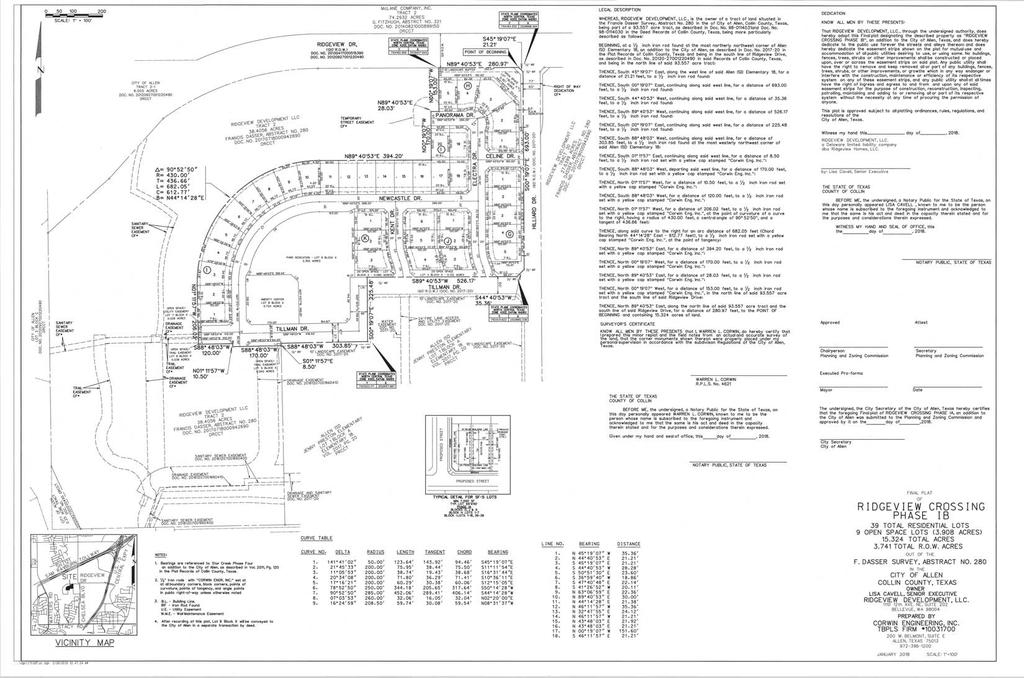
14 PLANNING & ZONING COMMISSION AGENDA COMMUNICATION AGENDA DATE: March 6, 2018 SUBJECT: STAFF RESOURCE: Consider a request for a Final Plat for Ridgeview Crossing Phase 1B, being ± acres located in the F. Dasser Survey, Abstract No. 280; generally located west of Chelsea Boulevard and south of the Ridgeview Drive right-of-way. (PL ) [Ridgeview Crossing Phase 1B] Hayley Angel Planner PREVIOUS COMMISSION/COUNCIL Alternative Screening Request Approved June, 2016 ACTION: General Development Plan Approved July, 2016 Planned Development No. 130 Approved June, 2017 Preliminary Plat Approved September, 2017 Planned Development No. 130 Amended January, 2018 LEGAL NOTICES: ANTICIPATED COUNCIL DATE: None. None. BACKGROUND The property is generally located east of Chelsea Boulevard and south of the Ridgeview Drive right-of-way. The property to the north (across the Ridgeview Drive right-of-way) is zoned Planned Development PD No. 92 Corridor Commercial CC. The properties to the east (across Hillard Drive) are zoned Planned Development PD No. 130 Single-Family Residential R-5. The properties to the south are zoned Planned Development PD No. 130 Single-Family Residential R-5 and Agricultural Open Space AO. The properties to the west are zoned Community Facilities CF and Agricultural Open Space AO. The property is zoned Planned Development PD No. 130 Single-Family Residential R-5. A Planned Development was approved by City Council in June 2017, and a Planned Development Amendment addressing the elevations was approved by City Council in January A Preliminary Plat was approved in September The Final Plat is the last step in the development process. The Preliminary Plat showed two phases of development. The subject Final Plat is for a portion of Phase 1, and shows ± acres of land subdivided into 39 residential lots and 9 Open Space/HOA lots. There are six points of access into this portion of the development; all six through internal drives. The plat also shows the various easements and right-of-way dedication required for development of the property. The Final Plat has been reviewed by the Technical Review Committee, is generally consistent with the PD Concept Plan and the Preliminary Plat, and meets the requirements of the Allen Land Development Code. STAFF RECOMMENDATION Staff recommends approval. MOTION I make a motion to approve the Final Plat for Ridgeview Crossing 1B; generally located west of Chelsea Boulevard and south of the Ridgeview Drive right-of-way.
15 Planning & Zoning Commission March 6, 2018 Ridgeview Crossing Phase 1B Page 2 ATTACHMENTS Final Plat
16
17 PLANNING & ZONING COMMISSION AGENDA COMMUNICATION AGENDA DATE: March 6, 2018 SUBJECT: STAFF RESOURCE: Conduct a Public Hearing and consider a request for a Replat for Lyrick Addition, Lots 1-AR, 2R, 3R, and 4-7, Block A, being ± acres; generally located south of Bethany Drive and west of Greenville Avenue. (PL ) [Lyrick Addition] Hayley Angel Planner PREVIOUS COMMISSION/COUNCIL Final Plat Approved July, 1985 ACTION: Preliminary Plan Approved August, 1999 Final Plat Approved August, 1999 Planned Development PD No. 131 Approved September, 2017 LEGAL NOTICES: ANTICIPATED COUNCIL DATE: None. None. BACKGROUND The property is generally located south of Bethany Drive and west of Greenville Avenue. The properties to the north (across Bethany Drive) are zoned Planned Development PD No. 3 Light Industrial LI, Planned Development PD No. 3 Shopping Center SC, and Local Retail LR. The properties to the east (across Greenville Avenue) are zoned Planned Development PD No. 4 Shopping Center SC. The properties to the south and west zoned Light Industrial LI. The property is currently zoned Planned Development PD No. 131 Shopping Center SC and Light Industrial LI. A PD Amendment for Lot 2R, Lots 4-7, a portion of 1-AR, and a portion of Lot 3R was approved by City Council in September Site Plans for Lots 2R, 3R, 4, and 6 are currently being reviewed. Platting is the last step in the development process. The Replat shows seven lots at approximately ± acres. There are a total of five primary access points into the property; three on Bethany Drive and two on Greenville Avenue. The plat also shows various easements and right-of-way dedication required for development of the property. The Replat has been reviewed by the Technical Review Committee and meets the standards of the Allen Land Development Code. STAFF RECOMMENDATION Staff recommends approval. MOTION I make a motion to approve a Replat for Lyrick Addition, Lots 1-AR, 2R, 3R, and 4-7, Block A; generally located south of Bethany Drive and west of Greenville Avenue.
18 Planning & Zoning Commission March 6, 2018 Lyrick Addition Page 2 ATTACHMENTS Replat
19 S58 C4 GREENVILLE ROAD STACY 135.6' ALLEN LIMIT CITY 30.35' 30' FIRE LANE, DRAINAGE & UTILITY ESMT, (A VARIABLE WIDTH RIGHT-OF-WAY) VOL PG. 428 CAB. B PG. 55 BETHANY DR. XF XF N31 13'20"E XS ' N74 02'38"W 13.18' N74 02'38"W XF XF 73.36' =16 31'51" R=675.87' L=195.00' =15 57'36" CB=S51 47'07"E 30.10' R=529.00' 26' FIRE LANE, L=147.36' C=194.32' 13.96' DRAINAGE & CB=N66 03'50"W UTILITY ESMT, =15 57'36" C=146.88' R=471.00' L=131.20' L5 =16 56'53" 5/8" IRFC R=690.86' CB=N66 03'50"W "HEWITT ZOLLARS" 14.41' L=204.36' C=130.78' L3 CB=S51 59'38"E WATER ESMT C=203.61' XF 6.15' 31.44' XF L7 IRSC C ' L8 XF N58 05'02"W L9 C12 S60 03'02"E 31.44' 6.75' 10.00' 30.00' C11 XS N: 'X 15' BDF E: S31 54'58"W DRAINAGE ESMT ' N14 59'52"W XF 5/8" IRFC 21.19' N31 54'58"E "HEWITT N58 05'02"W ZOLLARS" ' S31 54'58"W 41.45' ' RIGHT-OF-WAY DEDICATION XS XF XF XS 5/8" IRFC "HEWITT ZOLLARS" XS 5/8" IRFC "HEWITT ZOLLARS" XS XS XS WATER DRAINAGE CITY OF ALLEN CLERKS FILE NO LOT 1, BLK. A ALLEN MUNICIPAL SERVICE CENTER VOL PG ' BUILDING LINE VOL. L, PG ' BUILDING LINE VOL. L, PG. 501 ABANDONED ABANDONED FIRE LANE, MUTUAL ACCESS, DRAINAGE, DRAINAGE WATER & SANITARY SEWER NO-BUILD C.C.# XF FIRE LANE, MUTUAL ACCESS & DRAINAGE FIRE LANE, MUTUAL ACCESS & DRAINAGE PKF DRAINAGE & WATER FIRE LANE, MUTUAL ACCESS, DRAINAGE, WATER & SANITARY SEWER 5/8" IRF FIRE LANE, MUTUAL ACCESS, DRAINAGE, WATER & SANITARY SEWER 25' BUILDING SETBACK VOL. 2470, PG. 486 DRAINAGE 15' PARKING SETBACK VOL. 2470, PG. 486 WATER AND SANITARY SEWER N21 SANITARY SEWER LOT LINE ABANDONED FIRE LANE, MUTUAL ACCESS & 5/8" IRF N: E: /8" IRF XF SANITARY SEWER XF 1/2" IRF APPROX. SURVEY LINE CITY OF ALLEN CLERKS FILE NO LOT 1, BLK. A ALLEN MUNICIPAL SERVICE CENTER VOL PG. 81 WATER WATER VOL. 2010, PG ' FIRE LANE, ACCESS & UTILITY VOL. 2010, PG ' FIRE LANE, ACCESS & UTILITY VOL. 2010, PG. 81 VOL. 2010, PG. 81 WATER VOL. 2010, PG. 81 CENTERLINE OF 10' ELECTRIC 5/8" IRF VOL. 2010, PG ' PARKING SETBACK 15' PARKING SETBACK 15' LANDSCAPE WATER VOL. 2010, PG ' SOUTHWESTERN BELL 15' UTILITY TELEPHONE COMPANY VOL. 1255, PG. 437 VOL. 2470, PG ' BUILDING SETBACK VOL. 2470, PG ' BUILDING SETBACK VOL. 2470, PG. 486 VOL. 2470, PG. 486 VOL. 918, PG. 229 VOL. 2010, PG. 81 GREENVILLE AVE. (A VARIABLE WIDTH RIGHT-OF-WAY) VOL PG. 887 BILL & CINDY WATER FALLS LUBE AND WASH, LLC CAB. L PG. 501 CAB. K PG. 171 LOT 2 MARK VII EQUIPMENT OF TEXAS INC., GREENVILLE BETHANY DAVIDSON MATCH LINE FIRE LANE, ACCESS & UTILITY ESMT, INST. NO LOT 6 BLOCK A LOT 7 BLOCK A CAB. J, PG. 478 CORNER,LLC CLERKS FILE NO BETHANY CORNER ADDITION O.P.R.C.C.T. INST. NO CAB. F, PG. 171 LOT 1 O.P.R.C.C.T. LOT 1-AR BLOCK A ACRES 2.30' 1,080,168 SQ. FT ' L2 C3 S19 29'43"E ' S21 48'18"E ' LOT 3R BLOCK A ACRES 296,424 SQ. FT. DAVIDSON SUBDIVISION MARK VII EQUIPMENT OF TEXAS INC., CAB. J, PG. 478 CAB. G, PG. 700 LOT 2R BLOCK A ACRES ACRES 80,112 SQ. FT ACRES 37,644 SQ. FT. UTILITY ESMT, 30' FIRE LANE, ACCESS & 53,126 SQ. FT. LOT LINE ABANDONED 15' DRAINAGE ESMT. 10' SANITARY SEWER ESMT. WATER ESMT 12'X14' DRAINAGE ESMT. DRAINAGE ESMT. 26' FIRE LANE, DRAINAGE & UTILITY ESMT, 12'X14' DRAINAGE ESMT. 30' FIRE LANE, DRAINAGE & UTILITY ESMT, WATER ESMT 10'X10' WATER ESMT 10'X10' WATER ESMT DRAINAGE ESMT. 2.39' 15' DRAINAGE ESMT. L44 SANITARY SEWER ESMT. 10' WATER ESMT WATER ESMT C29 10'x10' WATER ESMT N68 56'02"W ' N90 00'00"E ' 15' DRAINAGE THIS PLAT LOT LINE ABANDONED S14 17'30"E ' S69 13'23"E ' S22 00'25"E ' N68 56'52"W 71.44' S67 59'35"W ' S20 45'30"W ' LOT 5 BLOCK A S31 15'06"W ' N30 09'12"W 88.95' =24 01'28" R=600.00' L=251.58' CB=S31 30'27"E C=249.74' =14 20'55" R=675.87' L=169.26' CB=S28 59'30"E C=168.82' N21 49'02"W ' 23.00' ' ' S21 03'58"W ' N68 56'02"W 37.50' 36.63' S66 03'58"W 57.72' N68 56'02"W 74.05' =5 06'36" R=529.00' L=47.18' CB=N71 29'20"W C=47.16' 20.53' 10.05' C48 L84 N21 03'58"E ' ' 99.90' L ' 6.44' 0.66' ' ' 66.46' ' 5.13' S17 09'01"W 29.26' 24.51' C ' ' L1 C ' 28.23' 26.05' 97.00' 10.60' 43.48' 8.03' L ' 5.16' L ' 12.05' 4.41' 14.31' 5.79' 6.79' 13.98' 17.64' ' S22 00'25"E ' N22 00'25"W ' ' 9.85' 18.02' 17.05' N31 15'06"E 62.57' S70 54'58"W ' N70 54'58"E ' S31 15'06"W ' S17 15'14"W 30.84' 3.79' 27.76' C ' =90 00'01" R=106.00' L=166.50' CB=N23 56'03"W C=149.91' 12.10' CB=N W C=62.64' N21 03'58"E ' N83 47'02"W 70.01' N21 03'58"E ' S21 03'58"W ' N68 56'02"W ' WATER S21 03'58"W ' S21 03'58"W ' S50 12'58"W 39.94' N68 56'02"W ' N68 56'02"W ' N68 56'02"W ' S68 56'02"E ' S1 00'58"W 49.45' N21 03'58"E ' C58 N21 03'58"E ' S68 56'02"E 42.82' N20 25'03"E ' N68 56'02"W ' C57 S68 56'02"E ' L36 C20 L35 S21 03'58"W ' L32L34 N68 56'02"W ' L17 L18 L20 L19 L21 L25 N80 00'42"E ' 35.57' N80 00'42"E ' L26 L14 L15 L24 L29 C17 L ' C22 L37 L43 C24 L65 C53 L ' L64 C21 C55L63 C25 C23 L40 L39 C54 C52 L45 L46 L48 L ' L47 L52 L41 L50 C56 L51 C34 L55 C36 C26 C33 C28 C27 L54 C32 C31 C30 L56 L57 L53 L27 C18 C ACRES 47,034 SQ. FT. LOT 4 BLOCK A FT ACRES 105,876 SF. S58 46'40"E ' 59.53' ' N58 46'40"W ' ' 34.64' 22.98' S58 46'40"E ' 51.57' C9 L4 N30 58'12"E ' C8 C6 C5 C10 S30 58'12"W ' L6 L10 C13 C14 L13 L ' L7 DWG NAME: K:\DAL_SURVEY\ SWC GREENVILLE BETHANY\DWG\ LYRICK REPLAT.DWG PLOTTED BY BROWN, DANA 2/21/2018 4:42 PM LAST SAVED 2/21/2018 4:41 PM C ' C76 L86 L85 C71 S41 46'56"E 36.16' 3.5' C72 L76 C68 L75 C67 S22 00'25"E ' N22 00'25"W ' N68 56'02"W ' LOT 1R, BLK. 1 RACETRAC NO BETHANY CENTER II VOL. 2015, PG. 486 O.P.R.C.C.T. C19 L23 GALARDI GROUP FRANCHISING & LEASING, INC LOT 1, BLOCK A COADALLEN PROPERTIES, LL VOL. 4356, PG. 962 L22 C15 N29 56'58"E ' ' ' 15.21'17.04' S29 56'58"W ' ACRES P.O.B. 13,408 SF. FT. N: E: LOT 3 BETHANY CENTER TWO CAB. K, PG. 848 ROWLETT OIL INST. NO SERVICES COMPANY VOL. 4834, PG LOT 1 TRACT 1 BETHANY CENTER TWO BROW, LLC CAB. F, PG. 455 ANDALUSIA PROPERTIES, INC. INST. NO O.P.R.C.C.T. ANDALUSIA PROPERTIES, INC. BETHANY ROAD OFFICE PARK VOL. 2017, PG. 987 INST. NO INST. NO O.P.R.C.C.T. O.P.R.C.C.T. O.P.R.C.C.T. O.P.R.C.C.T. TRACT A2R1 ALLEN BUSINESS CENTRE VOL. 2013, PG. 211 O.P.R.C.C.T. C50 L93 24' FIRE LANE, MUTUAL ACCESS & WATER 120.4' 132.3' C45 C43 L79 C42 C41 L62 C ' XF WILLIAM PERRIN SURVEY ABSTRACT NO. 708 XF L59 C38 XS L60 C39 L ' L61 L77 L78 C ' 57.8' 39.60' 29.00' C46 L ' L88 C37 L91 C47 L92 L58 C35 RUFUS SEWELL ABSTRACT NO. 875 FIRE LANE, MUTUAL ACCESS & SANITARY SEWER L89 DRAINAGE 24.85' 70.72' 9.91' 21.16' C49 FIRE LANE, ACCESS & UTILITY ESMT, 1.19' 41.00' 30.0' L95 L ' 29.30' L96 L97 LOT 3R BLOCK A ACRES 296,424 SQ. FT. L ' 125.0' 125.0' 110.0' GRAPHIC SCALE IN FEET " = 24X36 LEGEND: P.O.B. = POINT OF BEGINNING IRSC = 5/8" IRON ROD W/"KHA" CAP SET IRFC = IRON ROD W/CAP FOUND IRF = IRON ROD FOUND XF = X IN CONCRETE FOUND XS = X IN CONCRETE SET PKF = PK NAIL FOUND VOL. = VOLUME PG. = PAGE INST. NO. = INSTRUMENT NUMBER = MAP RECORDS OF COLLIN COUNTY, TEXAS O.P.R.C.C.T. = OFFICIAL PUBLIC RECORDS, COLLIN COUNTY, TEXAS BDF = TXDOT BRASS DISK FOUND OWNER LOT 3R CCI-Allen II, LP 800 Brazos Street Austin, Texas Contact: Andrew Dougntie OWNER LOT 1-AR LFP Real Estate, LP 200 E. Bethany Drive Allen, Texas Contact: Joseph Leach OWNER : LOT 2R, 4, 5, 6 AND 7 Greenville 2017, LP 5622 Dyer Street, Suite 200 Dallas, Texas Contact: Kent Stainback ENGINEER: Kimley-Horn and Associates, Inc Genesis Court, Suite 200 Frisco, Texas Phone : Contact: Carolyn Koch, PE NOTES: 1. According to Community Panel No J, dated June 2, 2009 of the National Flood Insurance Program Map, Flood Insurance Rate Map of Collin County, Texas, Federal Emergency Management Agency, Federal Insurance Administration, this property is within "Zone AE" and is within a special flood hazard area. If this site is not within an identified special flood hazard area, this flood statement does not imply that the property and/or the structures thereon will be free from flooding or flood damage. On rare occasions, greater floods can and will occur and flood heights may be increased by man-made or natural causes. This flood statement shall not create liability on the part of the surveyor. 2. The grid coordinates shown are based upon the Texas State Plane Coordinate System, North Central Zone, North American Datum of 1983, Zone 4202, on grid coordinate values, no scale and no projection. 3. The purpose of this replat is to revised the existing lot lines and dedicate right-of-way and easements. New easement labled with bold "BY THIS PLAT" REPLAT LYRICK ADDITION LOTS 1-AR, 2R, 3R, 4,5,6 AND 7 BLOCK A BEING ACRES, INCLUDING ACRE ROW DEDICATION AND BEING A REPLAT OF LOTS 1-3, BLOCK A, LYRICK ADDITION, AND BEING OUT OF THE RUFUS SEWELL SURVEY, ABSTRACT NO. 875 & WILLIAM PERRIN SURVEY, ABSTRACT NO. 708 CITY OF ALLEN, COLLIN COUNTY, TEXAS Noel Road, Two Galleria Office Tel. No. (972) Tower, Suite 700, Dallas, Texas FIRM # Fax No. (972) Scale Drawn by 1" = 50' DAB VICINITY MAP NORTH SITE N.T.S. BLUEBIRD Checked by Date Project No. Sheet No. JAD JAN OF 3 NORTH
20 N58 59'00"W ' (A VARIABLE WIDTH RIGHT-OF-WAY) BETHANY DR. VOL PG. 428 CAB. B PG. 55 L71 S58 59'00"E ' S58 59'00"E ' N21 03'58"E ' C ' FLOODWAY APPROXIMATE LOCATION OF 24' TEXAS POWER & LIGHT CO. VOL. 2212, PG. 745 FIRE LANE, MUTUAL ACCESS & WATER WATER 10' TU ELECTRIC VOL. 4006, PG ' TU ELECTRIC VOL. 4006, PG FIRE LANE, MUTUAL ACCESS & WATER XF DRAINAGE XS XS SANITARY SEWER DRAINAGE & WATER DRAINAGE NO-BUILD C.C.# /8" IRF ARY SEWER 010, PG. 81 C.T. DRAINAGE 25' BUILDING SETBACK VOL. 2470, PG ' PARKING SETBACK VOL. 2470, PG /8" IRF 5/8" IRF XF IRSC N: E: ' DALLAS AREA RAPID TRANSIT 100' ROW EXTRA SPACE PROPERTIES TWENTY EIGHT LLC INST. NO O.P.R.C.C.T. S21 03'57"W ' N21 03'59"E ' S68 56'02"E ' S5 11'58"W ' N21 03'59"E ' ' N21 03'57"E ' S21 03'57"W ' =89 13'14" R=130.00' L=202.44' CB=S24 20'31"E C=182.59' =96 34'11" R=106.00' L=178.66' CB=S20 40'02"E 1/2" IRF C=158.25' 100' BUILDING LINE VOL. L, PG. 501 ABANDONED LOT 1-AR BLOCK A ACRES 1,080,167 SQ. FT. WILLIAM PERRIN SURVEY ABSTRACT NO. 708 RUFUS SEWELL ABSTRACT NO /2" IRF MATCH LINE LOT 1-AR BLOCK A ACRES 1,080,168 SQ. FT. AP CITY OF ALLEN CLERKS FILE NO N21 12'45"E 86.33' 26.05' FIRE LANE, ACCESS & UTILITY ESMT, =47 07'45" R=467.49' L=384.54' CB=S45 22'10"E C=373.79' 8 00' L ' LOT 1, BLK. A ALLEN MUNICIPAL SERVICE CENTER VOL PG. 81 FIRE LANE, MUTUAL ACCESS, DRAINAGE, WATER & SANITARY SEWER ABANDONED 14.08' 97.00' 2.30' 9.18' =89 14'14" R=130.00' L=202.47' CB=S65 41'02"W C=182.62' =88 40'35" R=106.00' L=164.06' CB=S65 24'12"W C=148.17' S21 03'57"W ' N21 03'58"E 54.05' C74 C ' ' N21 03'57"E ' S27 37'58"W ' S68 56'03"E ' S68 56'03"E ' =90 00'01" R=106.00' L=166.50' CB=N23 56'03"W C=149.91' =27 51'20" R=130.12' L=63.26' CB=N54 59'36"W C=62.64' S21 03'58"W ' N18 58'52"W ' N58 59'00"W ' S50 12'58"W 39.94' N68 56'03"W 7.02' N21 03'58"E ' N21 03'58"E ' N83 47'02"W 70.01' C ' C76 L86 N68 56'02"W 19 N68 56 S68 5 S21 12'45"W 25.37' N21 03'58"E ' L83 L82 C65 N8 34'36"E 27.06' S68 56'01"E 20.00' TRACT B ALLEN BUSINESS CENTRE CAB. P, PG. 943 PRESTIGE CIR. RIGHT-OF-WAY A VARIABLE WIDTH 123.8' O.P.R.C.C.T. INST. NO GIOVANNI ROMAN DAVID ROMAN AND LOT 1A-R ALLEN BUSINESS CENTRE-TRACT A1 VOL. 2006, PG ' O.P.R.C.C.T ' COADALLEN PROPERTIES, LLC INST. NO O.P.R.C.C.T. TRACT A2R1 ALLEN BUSINESS CENTRE VOL. 2013, PG. 211 O.P.R.C.C.T. 24' FIRE LANE, MUTUAL ACCESS & WATER 120.4' FIRE LANE, ACCESS & UTILITY ESMT, 1 19' MRCCT L81 C64 C63 L70 L72 L69 C ' L73 C61 L67 L68 C60 C59 L ' 62.29' DWG NAME: K:\DAL_SURVEY\ SWC GREENVILLE BETHANY\DWG\ LYRICK REPLAT.DWG PLOTTED BY BROWN, DANA 2/21/2018 4:42 PM LAST SAVED 2/21/2018 4:41 PM C50 L ' NORTH S29 43'08"E 31.69' S12 13'45"W 55.41' APPROX. LOCATION OF 100-YR FEMA FLOODPLAIN ' S19 13'59"W 71.95' 11.67' L99 FLOODWAY ESMT. DRAINAGE 29.89' 30.60' L ' S10 46'20"W S36 17'15"W 43.12' 29.62' NOTES: 1. According to Community Panel No J, dated June 2, 2009 of the National Flood Insurance Program Map, Flood Insurance Rate Map of Collin County, Texas, Federal Emergency Management Agency, Federal Insurance Administration, this property is within "Zone AE" and is within a special flood hazard area. If this site is not within an identified special flood hazard area, this flood statement does not imply that the property and/or the structures thereon will be free from flooding or flood damage. On rare occasions, greater floods can and will occur and flood heights may be increased by man-made or natural causes. This flood statement shall not create liability on the part of the surveyor. 2. The grid coordinates shown are based upon the Texas State Plane Coordinate System, North Central Zone, North American Datum of 1983, Zone 4202, on grid coordinate values, no scale and no projection. 3. The purpose of this replat is to revised the existing lot lines and dedicate right-of-way and easements. New easement labled with bold "BY THIS PLAT" LEGEND: P.O.B. = POINT OF BEGINNING IRSC = 5/8" IRON ROD W/"KHA" CAP SET IRFC = IRON ROD W/CAP FOUND GRAPHIC SCALE IN FEET IRF = IRON ROD FOUND XF = X IN CONCRETE FOUND XS = X IN CONCRETE SET 1" = 24X36 PKF = PK NAIL FOUND VOL. = VOLUME PG. = PAGE INST. NO. = INSTRUMENT NUMBER = MAP RECORDS OF COLLIN COUNTY, TEXAS O.P.R.C.C.T. = OFFICIAL PUBLIC RECORDS, COLLIN COUNTY, TEXAS BDF = TXDOT BRASS DISK FOUND OWNER LOT 3R CCI-Allen II, LP 800 Brazos Street Austin, Texas Contact: Andrew Dougntie OWNER LOT 1-AR LFP Real Estate, LP 200 E. Bethany Drive Allen, Texas Contact: Joseph Leach Noel Road, Two Galleria Office Tel. No. (972) Tower, Suite 700, Dallas, Texas FIRM # Fax No. (972) Scale Drawn by 1" = 50' DAB OWNER : LOT 2R, 4, 5, 6 AND 7 Greenville 2017, LP 5622 Dyer Street, Suite 200 Dallas, Texas Contact: Kent Stainback ENGINEER: Kimley-Horn and Associates, Inc Genesis Court, Suite 200 Frisco, Texas Phone : Contact: Carolyn Koch, PE Checked by Date Project No. Sheet No. JAD JAN OF 3 REPLAT LYRICK ADDITION LOTS 1-AR, 2R, 3R, 4,5,6 AND 7 BLOCK A BEING ACRES, INCLUDING ACRE ROW DEDICATION AND BEING A REPLAT OF LOTS 1-3, BLOCK A, LYRICK ADDITION, AND BEING OUT OF THE RUFUS SEWELL SURVEY, ABSTRACT NO. 875 & WILLIAM PERRIN SURVEY, ABSTRACT NO. 708 CITY OF ALLEN, COLLIN COUNTY, TEXAS N68 56'02"W ' C58
Synergy Park Addition (Companion to item 3)
") Synergy Park Addition (Companion to item 3) Attachments: 1. Locator 2. Replat staff report 3. Replat W P G r es rg eo e s Bu hh wy Lot 6A 4.02-acres Lot 4C 13.02-acres Fran k Lots 4C and 6A, Block A Synergy
Synergy Park Addition (Companion to item 3) Attachments: 1. Locator 2. Replat staff report 3. Replat W P G r es rg eo e s Bu hh wy Lot 6A 4.02-acres Lot 4C 13.02-acres Fran k Lots 4C and 6A, Block A Synergy
Memorandum September 13, 2018
 Memorandum September 13, 2018 TO: FROM: Planning and Zoning Commission Julie Couch, Town Manager Israel Roberts, AICP Planning Manager SUBJECT: FINAL PLAT FOR THE EBERSOHL ADDITION BACKGROUND: This is
Honorable Mayor Bill Agan and members of the Richland Hills City Council. Final Plat Richland Hills, Lots 1 & 2, Block 1 Brumlow Addition
 2B - 1 Memorandum To: From: Date: Subject: Honorable Mayor Bill Agan and members of the Richland Hills City Council Jason Moore, Assistant City Manager January 17, 2017 Final Plat Richland Hills, Lots
STANDARD LANGUAGE FORMAT GUIDE PLANNING SERVICES DIVISION
 A. OWNERSHIP CERTIFICATE The purpose of the ownership certificate is to identify the owner and provide the Volume and Page of Deed Records, verifying the ownership. When the property owner is a corporation,
PLANNING & ZONING COMMISSION Town of Little Elm
 PLANNING & ZONING COMMISSION Town of Little Elm Work Session and Regular Meeting Thursday, June 15, 2017 Town Hall - Council Chamber & Conference Room To address the Commission for any public hearing item
AMENDING PLAT REQUIREMENTS Revised
 City of University Park AMENDING PLAT REQUIREMENTS Revised 10-2016 1. The amending plat is prepared with the appropriate certificates printed on the document and three (3) 24 x 36 paper copies are submitted
REPLAT REQUIREMENTS Revised
 City of University Park REPLAT REQUIREMENTS Revised 02-2016 1. The replat is prepared with the appropriate certificates printed on the document and three (3) 24 x 36 paper copies are submitted with a completed
City of Grand Forks Staff Report
 City of Grand Forks Staff Report Planning and Zoning Commission March 6, 2019 City Council March 18, 2019 Agenda Item: 4-1 (Preliminary) Preliminary approval of the plat of University Place First Resubdivision
For the purposes of this resolution, the following definitions of terms
 COUNCIL CHAMBER February 23, 2011 A RESOLUTION DETERMINING UPON THE NECESSITY OF ACQUIRING REAL PROPERTY AND AUTHORIZING ITS APPROPRIATION ANDIOR CONDEMNATION FOR A MUNICIPAL PURPOSE AND PUBLIC USE. DEFINITIONS:
Preliminary Plat/Final Plat Application
 Melissa Municipal Center 3411 Barker Avenue Melissa, Texas 75454 Phone: (972) 838-2036 Applicant: Date: Address: Phone: Contact: Fax: E-mail: Propose Addition Name: Acres: Existing Zoning: Propose Zoning:
AGENDA PLANNING AND ZONING COMMISSION DECEMBER 5, Council Chambers 151 West Church Street Lewisville, Texas 6:30 P.M.
 AGENDA PLANNING AND ZONING COMMISSION DECEMBER 5, 2017 Council Chambers 151 West Church Street Lewisville, Texas 6:30 P.M. 1. CALL TO ORDER AND ANNOUNCE THAT A QUORUM IS PRESENT. 2. APPROVE MINUTES OF
PRIME HIGHWAY LOCATION Multi - Family Land Acres Waxahachie, Texas
 PRIME HIGHAY LOCATION Multi - Family Land 6.525 Acres axahachie, Texas LOCATION: SIZE: The subject property is located on the south side of U.S. Highway 287 Bypass, approximately 1.5 miles west of I-35E
Planning. the propertyy. Texas Local. Government. Code. size of 2,0000 RSF-2-PUD. Road within the Wharf at a. Citizen. 0 Letter of. 1.
 Planning & Zoning Commissionn Replat Phase I of the Wharf at Clear Lake, Dock 18, Slips 1 and 2 Planning & Development Department February 15, 20166 Request Replat approximately 0.0209 acres of a previouslyy
Planning. Preliminary. .70 acres into. tract of land. an unplatted. Edgar Barlow. 1. Proposed 2. Aerial Map. Subdivision
 Preliminary / Final Plat Glenmont, Section Two Planning & Zoning Commissionn Planning & Development Department May 19, 20144 Request Applicant Owner Zoning Location Attachments Subdivide approximately.70
AMENDING PLAT REQUIREMENTS Revised
 City of University Park AMENDING PLAT REQUIREMENTS Revised 9-3-2014 1. The amending plat is prepared with the appropriate certificates printed on the document and three (3) 24 x 36 paper copies are submitted
Oakland County Michigan Register of Deeds Plat Engineering, GIS, & Remonumentation Dept. Ph: (248) Fax (248)
 Fax (248)") Oakland County Michigan Register of Deeds Plat Engineering, GIS, & Remonumentation Dept. Ph: (248)-858-1447 Fax (248)-858-7466 Requirements Needed for Final Plat Approval No. General Requirements. 1 Routing
Oakland County Michigan Register of Deeds Plat Engineering, GIS, & Remonumentation Dept. Ph: (248)-858-1447 Fax (248)-858-7466 Requirements Needed for Final Plat Approval No. General Requirements. 1 Routing
ORDINANCE NO
 ORDINANCE NO. 3 0 3 5 7 170302 An ordinance providing for the abandonment of portions of two alleys and portions of Texas, Live Oak, and Cantegral Streets, located adjacent to City Block 289 in the City
LOCATION MAP: AERIAL PHOTOGRAPH, 2015:
 LOCATION MAP: AERIAL PHOTOGRAPH, 2015: ORDINANCE NO. AN ORDINANCE OF THE CITY OF BRYAN, TEXAS, AMENDING CHAPTER 130, ZONING, OF THE CITY OF BRYAN CODE OF ORDINANCES, BY CHANGING THE ZONING CLASSIFICATION
1. Action taken on the Planning & Zoning Commission items by City Council at the April 26, 2016, and May 10, 2016, regular meetings.
 AGENDA CITY OF ALLEN PLANNING AND ZONING COMMISSION REGULAR MEETING TUESDAY, MAY 17, 2016 7:00 P.M. CITY COUNCIL CHAMBERS ALLEN CITY HALL 305 CENTURY PARKWAY ALLEN, TEXAS 75013 Call to Order and Announce
City of Melissa, Texas Plat Dedication Language
 City of Melissa, Texas Plat Dedication Language [INCLUDE THE FOLLOWING DEDICATION LANGUAGE FOR INDIVIDUALS (MODIFY APPROPRIATELY TO REFLECT EXACTLY AS SHOWN ON PROPERTY DEED)]: NOW THEREFORE, KNOW ALL
A Preliminary Plat is required in addition to a Final Plat or Replat if any of the following apply:
 DO YOU NEED A PLAT? City of Grapevine, Texas PLATTING INFORMATION Updated July 22, 2014 Public Works Department Engineering Division 200 South Main Street Grapevine, Texas 76051 Tele: 817.410.3136 Fax:
Conveyance of City Land at Intersection of Grady Avenue and Preston Avenue
 CITY OF CHARLOTTESVILLE, VIRGINIA CITY COUNCIL AGENDA Agenda Date: June 5, 2017 Action Required: Presenter: Staff Contacts: Title: Public Hearing and Adoption of Ordinance S. Craig Brown, City Attorney
LOCATION MAP SHEET 1 OF 10
 OWNER: ADDRESS: LOCATION MAP CENTURY LAND HOLDINGS II, LLC 6500 RIVER PLACE BLVD. BUILDING 2, SUITE 200 AUSTIN, TX 78730 OWNER: CITY OF LEANDER ADDRESS: P.O. BOX 319 LEANDER, TX 78646 ACREAGE: LOTS ACREAGE:
NOT TO BE SUBMITTED WITH SKETCH DESIGN APPROVAL Subdivision Checklist: Major Subdivision Final Plat
 Must be received with review fee (equal to $200.00, plus $25.00 per lot) no later than 15 days prior to Planning Board meeting, which is normally the first Monday of the month (certain holidays may modify
SUBDIVISION APPLICATION
 SUBDIVISION APPLICATION City of Horn Lake Planning Department 3101 Goodman Road, W Horn Lake, MS 38637 662-342-3559 Fax: 662-342-3485 Applications due the 1st working day of the month. Submit application
WASTEWATER BACKFLOW RELEASE PROCEDURES
 WASTEWATER BACKFLOW RELEASE PROCEDURES PROCEDURE FOR OBTAINING A WASTEWATER RELEASE FOR PRIVATE DEVELOPMENT PROJECTS: PLEASE NOTE THAT THE WASTEWATER BACKFLOW RELEASE DOCUMENT MUST FOLLOW THE CITY S PROCEDURES.
$5,462 ($3,762, plus closing costs not to exceed
 4: Q i Jtwié9,21O A RESOLUTION DETERMINING UPON THE NECESSITY OF ACQUIRING REAL PROPERTY AND AUTHORIZING ITS APPROPRIATION AND/OR CONDEMNATION FOR A MUNICIPAL PURPOSE AND PUBLIC USE. DEFINITIONS: shall
DALLAS WATER UTILITIES WATER/WASTEWATER COVENANT
 DALLAS WATER UTILITIES WATER/WASTEWATER COVENANT Procedure for obtaining a water and wastewater covenant, water covenant, or wastewater covenant; Required for initial submittal: 1. One letter from the
WATERFORD LANDING COMMUNITY DEVELOPMENT DISTRICT REGULAR MEETING AGENDA
 WATERFORD LANDING COMMUNITY DEVELOPMENT DISTRICT REGULAR MEETING AGENDA January 31, 2019 Waterford Landing Community Development District OFFICE OF THE DISTRICT MANAGER 2300 Glades Road, Suite 410W Boca
CITY OF DECATUR, TEXAS
 Final Plat or Amending Plat / Replat Checklist A submittal of a complete application will facilitate a timely review. Failure of the applicant to provide required information or obtain a waiver from the
MINOR PLAT. The following documents are provided as required by the City of Conroe for use in the above titled platting submittals:
 Public Works - Engineering Division CITY OF CONROE MINOR PLAT The following documents are provided as required by the City of Conroe for use in the above titled platting submittals: Submittal Questionnaire
Final Plat Mapping Requirements
 CURRENT PLANNING DIVISION 410 E. 5 th Street Loveland, CO 80537 970-962-2523 eplan-planning@cityofloveland.org cityofloveland.org/dc Final Plat Mapping Requirements All Final plats shall comply with the
E. 140TH AVE. VICINITY MAP SCALE: 1"=600' LAND USE TABLE NET AREA 599,946 SQFT AC. GROSS AREA 741,420 SQFT AC.
 SHEET OF PURPOSE STATEMENT: THIS PLAT IS INTENDED TO SUBDIVIDE. ACRES INTO SINGLE FAMILY ATTACHED LOTS, TRACTS, DEDICATE AND GRANT EASEMENTS. LEGAL DESCRIPTION: THE UNDERSIGNED BEING THE OWNER(S) OF A
2800 OAK LAWN AVENUE ± 25,000 SF ON OAK LAWN AVE AVAILABLE FOR LEASE. SEC Oak Lawn Ave & Congress Ave Dallas, Texas EDGE REALTY PARTNERS
 ± 25,000 SF ON OAK LAWN AVE AVAILABLE FOR LEASE 2800 OAK LAWN AVENUE SEC Oak Lawn Ave & Congress Ave Dallas, Texas EDGE REALTY PARTNERS LOCATION 2800 Oak Lawn Avenue Dallas, Texas 75219 SIZE ± 25,000 square
PLANNED DEVELOPMENT DISTRICT A ACRE TRACT KNOWN AS GEAN ESTATES CITY OF KELLER, TARRANT COUNTY TEXAS
 PLANNED DEVELOPMENT DISTRICT A 105.026 ACRE TRACT KNOWN AS GEAN ESTATES CITY OF KELLER, TARRANT COUNTY TEXAS A. Exhibit A Development Regulations B. Exhibit B Legal Description C. Exhibit C Conceptual
AGENDA ITEM G-2 Public Works
 AGENDA ITEM G-2 Public Works STAFF REPORT City Council Meeting Date: 2/23/2016 Staff Report Number: 16-035-CC Consent Calendar: Adopt a resolution accepting Easements and approving the abandonment of two
PART OF SECTION 9, TOWNSHIP 36 NORTH, RANGE 9 EAST OF THE THIRD PRINCIPAL MERIDIAN, NORTH OF THE INDIAN BOUNDRY LINE, IN WILL COUNTY, ILLINOIS.
 PART OF SECTION 9, TOWNSHIP 6, RANGE 9 EAST OF THE THIRD PRINCIPAL MERIDIAN, OF THE INDIAN BOUNY LINE, IN WILL COUNTY, ILLINOIS. ASSUMED THE LINE OF THE WEST / OF SECTION 9-6-9 TO BE: S89 5' 7"E 60 0 0
Department of Development Services Engineering; Survey Plat Review Group SPRG
 Department of Development Services Engineering; Survey Plat Review Group SPRG CITY OF DALLAS LEGAL DESCRIPTION PREPARATION GUIDELINE AND CHECKLIST The following guideline and checklist are provided to
Sketch & Legal Description of Mitigation Bank and Ingress/Egress Access Easements
 Appendix H: Sketch & Legal Description of Mitigation Bank and Ingress/Egress Access Easements Tippen Bay Wetland Mitigation Bank DeSoto County, Florida Prepared by: September, 2017 Original file
VICINITY MAP SCALE 1'' = 2000'
 CITY CREEK ANNEXATION TO THE CITY OF THORNTON LOCATED IN THE SOUTHWEST QUARTER OF SECTION 11 AND THE WEST HALF OF SECTION 14, TOWNSHIP 1 SOUTH, RANGE 68 WEST OF THE 6TH PRINCIPAL MERIDIAN, COUNTY OF ADAMS,
CERTIFIED SURVEY MAP
 SCONSIN STATE PLANE N:389676.12 E:2130390.15 Center of Section 23 CERTIFIED SURVEY MAP 734.06' THE (PRITCHETTE) ORIGINAL PLAT OF ALL IN THE NW 1 4 OF THE SE 1 4 OF FRACTIONAL SECTION 23, T7N, R9E, IN THE
QUEBEC STREET EAST 130TH AVENUE ONEIDA STREET E. 130TH AVE. VALENTIA ST TAMARAC ST EAST 128TH AVENUE MOACO STREET BACHMAN DR. SITE QUINCE ST.
 SHEET OF CASE NO.: SUBA - PURPOSE STATEMENT: THIS PLAT IS INTENDED TO SUBDIVIDE. ACRES INTO SINGLE FAMILY LOTS, AND TRACTS FOR PARKS, OPEN SPACE, DRAINAGE AND DETENTION, DEDICATE RIGHT-OF-WAY AND GRANT
QUEBEC STREET EAST 130TH AVENUE ONEIDA STREET E. 130TH AVE. VALENTIA ST TAMARAC ST EAST 128TH AVENUE MONACO STREET BACHMAN DR. SITE QUINCE ST.
 SHEET OF CASE NO.: SUBA 0-0 PURPOSE STATEMENT: THIS PLAT IS INTENDED TO SUBDIVIDE. ACRES INTO 0 SINGLE FAMILY LOTS, AND TRACTS FOR PARKS, OPEN SPACE, DRAINAGE AND DETENTION, DEDICATE RIGHT-OF-WAY AND GRANT
A portion of the land (surplus land), described in Exhibit A, is no longer needed for a state highway purpose.
, described in Exhibit A, is no longer needed for a state highway purpose.") TEXAS TRANSPORTATION COMMISSION DENTON County MINUTE ORDER Page 1 of 2 DALLAS District In the city of Northlake, DENTON COUNTY, on INTERSTATE 35W, the State of Texas (state) acquired certain land for a
TEXAS TRANSPORTATION COMMISSION DENTON County MINUTE ORDER Page 1 of 2 DALLAS District In the city of Northlake, DENTON COUNTY, on INTERSTATE 35W, the State of Texas (state) acquired certain land for a
Planning Commission Application Summary
 Planning Commission Application Summary Project Name: Academy Office Park Plat Amendment Request Address: 339 West 13490 South Current Zoning: CSD-DPMU Hearing Date: August 11, 2016 Summary of Request
The City Council of the City of Sulphur, Louisiana, met in special session at its
 July 12, 2018 The City Council of the City of Sulphur, Louisiana, met in special session at its regular meeting place in the Council Chambers, Sulphur, Louisiana, on July 12, 2018 at 5:00 p.m., after full
QUITCLAIM DEED CR 202 THE STATE OF TEXAS KNOW ALL MEN BY THESE PRESENTS: COUNTY OF WILLIAMSON
 QUITCLAIM DEED CR 202 THE STATE OF TEXAS KNOW ALL MEN BY THESE PRESENTS: COUNTY OF WILLIAMSON That WILLIAMSON COUNTY, TEXAS, hereinafter referred to as Grantor, whether one or more, for and in consideration
SUBDIVISION APPLICATION
 SUBDIVISION APPLICATION Preliminary Plat Minor Plat Final Plat Amended Plat Applicant Name: Owner (if different from applicant) Name: Company: Company: Address: Address: City, State, Zip City, State, Zip
COUNCIL AGENDA MEMO ITEM NO. III - #1
 COUNCIL AGENDA MEMO ITEM NO. III - #1 FROM: Anton Jelinek, Director of Utilities MEETING: October 24, 2017 SUBJECT: PRESENTER: Permanent Utility and Right-of-Way Easement Anton Jelinek Discussion: At the
RULES, REGULATIONS AND REQUIREMENTS RELATING TO THE APPROVAL AND ACCEPTANCE OF IMPROVEMENTS IN SUBDIVISIONS OR RE-SUBDIVISIONS
 GALVESTON COUNTY RULES, REGULATIONS AND REQUIREMENTS RELATING TO THE APPROVAL AND ACCEPTANCE OF IMPROVEMENTS IN SUBDIVISIONS OR RE-SUBDIVISIONS GALVESTON COUNTY ENGINEERING DEPARTMENT MARCH 3, 1997 Amendment
Community Development Department Council Chambers, 7:30 PM, July 20, 2017
 STAFF REPORT 2017-25P: Subdivision Community Development Department Council Chambers, 7:30 PM, July 20, 2017 To: From: Re: Paul Luke, Chairman, Skokie Plan Commission Mike Voitik, Planning Technician 2017-25P:
CITY OF LUCAS. Preliminary and Final Plat Application Guidelines. 665 Country Club Road Lucas, Texas Office
 CITY OF LUCAS Preliminary and Final Plat Application Guidelines 665 Country Club Road Lucas, Texas 75002 Office 972.912.1207 www.lucastexas.us PLATTING APPLICATION Name of Subdivision and/or Project: Items
MINOR PLAT FILING APPLICATION
 FILING APPLICATION Date of PC Meeting: Date of BCC Meeting: Fee Paid: 1. APPLICANT: DAYTIME PHONE: MAILING ADDRESS: LANDOWNER: DAYTIME PHONE: MAILING ADDRESS: AUTHORIZED AGENT: MAILING ADDRESS: RELATIONSHIP
CONVEYANCE - COMMONWEALTH PROPERTY IN THE BOROUGH OF EAST STROUDSBURG, MONROE COUNTY Act of Jul. 1, 2016, P.L., No. 65 Cl.
 CONVEYANCE - COMMONWEALTH PROPERTY IN THE BOROUGH OF EAST STROUDSBURG, MONROE COUNTY Act of Jul. 1, 2016, P.L., No. 65 Cl. 85 An Act Authorizing the Department of General Services, with the approval of
ORDINANCE NO. An ordinance providing for the abandonment and relinquishment of portions of three
 Dallas, Texas; providing for the quitclaim thereof to ATA Apartments Limited An ordinance providing for the abandonment and relinquishment of portions of three ORDINANCE NO. 2 90 7 7 storm sewer easements
2213 BUTLER PAD SITE NEAR NEW PARKLAND HOSPITAL. Butler Street at Redfield Dallas, Texas EDGE REALTY PARTNERS
 PAD SITE NEAR NEW PARKLAND HOSPITAL 2213 BUTLER Butler Street at Redfield Dallas, Texas EDGE REALTY PARTNERS 2213 BUTLER // Dallas, Texas LOCATION 2213 Butler Street Dallas, Texas 75235 SIZE 83,370 square
PLATTING. Applications are accepted by the Planning Department on or before the last Wednesday of each month.
 PLATTING GENERAL INFORMATION Platting is the process by which land is subdivided. The plat review process is intended to determine if the subdivision layout is in compliance with the City of Carrollton
Resolution : A Resolution Recommending Approval Of Preliminary and Final Plats For Emma Krumbees Third Addition
 MEMORANDUM June 11, 2018 TO: FROM: SUBJECT: Planning Chairperson Carter Planning Commission Members Administrator Meyer Cynthia Smith Strack, Community Development Director Resolution 18 013: A Resolution
FINAL PLAT. Community Development Department 8101 Ralston Road Arvada, Colorado 80002
 FINAL PLAT Community Development Department 8101 Ralston Road Arvada, Colorado 80002 September 2015 FINAL SUBDIVISION PLAT Final Subdivision Plat Review Applications for a Final Plat shall be submitted
PLANNED DEVELOPMENT DISTRICT A ACRE TRACT KNOWN AS GEAN ESTATES CITY OF KELLER, TARRANT COUNTY TEXAS
 PLANNED DEVELOPMENT DISTRICT A 123.359 ACRE TRACT KNOWN AS GEAN ESTATES CITY OF KELLER, TARRANT COUNTY TEXAS A. Exhibit A Development Regulations B. Exhibit B Legal Description C. Exhibit C Conceptual
AGENDA HAYDEN PLANNING COMMISSION
 AGENDA HAYDEN PLANNING COMMISSION THURSDAY, DECEMBER 14, 2017 7:00 P.M. HAYDEN TOWN HALL 178 WEST JEFFERSON AVENUE REGULAR MEETING 1. CALL TO ORDER, MOMENT OF SILENCE & PLEDGE OF ALLEGIANCE 2. ROLL CALL
MINOR SUBDIVISION PLAT
 MINOR SUBDIVISION PLAT Community Development Department 8101 Ralston Road Arvada, Colorado 80002 MINOR SUBDIVISION PLAT Subdivisions consisting of five (5) or fewer lots are eligible for the minor subdivision
APPENDIX C: PLAT SPECIFICATIONS AND CERTIFICATES
 APPENDIX C: PLAT SPECIFICATIONS AND CERTIFICATES A. Drawing. All plats for recording must be submitted on photographically reproducible and dimensionally stable polyester sheets such as Mylar, Cronar or
CLARK 3925 E. US 377 COMMERCIAL $699,000 COMMERCIAL PAD SITE IN FRONT OF NEW KROGER. Granbury, Texas
 PAD SITE IN FRONT OF NEW KROGER $699,000 1.858 Acres Monument sign on 377 377 road frontage Platted Zoned Utilities to the site PROPERTY INFORMATION Property Information: Adjacent to recently opened Kroger
MINOR SUBDIVISION PLAT
 MINOR SUBDIVISION PLAT Community Development Department 8101 Ralston Road Arvada, Colorado 80002 September 2015 MINOR SUBDIVISION PLAT Subdivisions consisting of five (5) or fewer lots are eligible for
CITY OF LEE S SUMMIT MINOR PLAT PROCESS. Purpose of Minor Plats
 MINOR PLAT PROCESS Purpose of Minor Plats The City of Lee s Summit requires that all property be platted before a building permit is issued. Platting involves the subdivision of land into lots or tracts.
MINOR SUBDIVISION PLAT CHECKLIST
 MINOR SUBDIVISION PLAT CHECKLIST Project Name: Tax ID #: Project Number: Date: _ Reviewed By: Telephone: NOTES: All lots on septic systems must comply with the Fulton County Health Department requirements
ADMINISTRATIVE HEARING STAFF REPORT Country Club Acres Second Amended Subdivision Amendment PLNSUB E Parkway Avenue December 12, 2013
 ADMINISTRATIVE HEARING STAFF REPORT Country Club Acres Second Amended Subdivision Amendment PLNSUB2013-00925 2167 E Parkway Avenue December 12, 2013 Planning Division Department of Community & Economic
Februarv27, WHEREAS, the City of Dallas owns tracts of land which are used for Lake Ray. Hubbard; and
 WHEREAS, the City of Dallas owns tracts of land which are used for Lake Ray WHEREAS, the City of Rowlett has requested a wastewater easement with a temporary Hubbard; and Februarv27, 213 By: Assistant
As Introduced. 131st General Assembly Regular Session H. B. No
 131st General Assembly Regular Session H. B. No. 239 2015-2016 Representative Sears A B I L L To amend section 5120.092 and to enact section 5120.80 of the Revised Code to allow the Director of Budget
PROPERTY DESCRIPTION: Property is located in: City Limits County(Outside City Limits) Site Address/Location:
 Site Address/Location:") Application for Lot-Tract Split/Combo or Property Line Adjustment CITY OF CENTERTON PLANNING DEPARTMENT 290 N. MAIN ST., P.O. BOX 208 CENTERTON, AR 72719 PHONE (479)795-2750 FAX (479)795-2545 Planning@centertonar.us
Application for Lot-Tract Split/Combo or Property Line Adjustment CITY OF CENTERTON PLANNING DEPARTMENT 290 N. MAIN ST., P.O. BOX 208 CENTERTON, AR 72719 PHONE (479)795-2750 FAX (479)795-2545 Planning@centertonar.us
OWNERS ACKNOWLEDGMENT
 OWNERS ACKNOWLEDGMENT STATE OF TEXAS COUNTY OF GALVESTON/HARRIS I (or we), (name of owner or owners) acting by and through (name and title of officer) being officers of (name of company or corporation),
ORDINANCE NO
 ORDINANCE NO. 3 0 3 1 1 170133 An ordinance providing for the abandonment and relinquishment of portion of a sanitary sewer easement, located in City Block 245 in the City of Dallas and County of Dallas,
SUBDIVISION PLAT CHECKLIST. The following information shall be include on the plat:
 SUBDIVISION PLAT CHECKLIST Subdivision Name: Land Surveyor: Owner/Developer: Date Submitted: The following information shall be include on the plat: The plat shall be drawn at a scale of one inch equals
Planning Commission Work Meeting Minutes Thursday, October 18, 2018 City Council Chambers 220 East Morris Avenue Time 6:45 p.m.
 Planning Commission Work Meeting Minutes Thursday, October 18, 2018 City Council Chambers 220 East Morris Avenue Time 6:45 p.m. Commission Members Present: Jeremy Carter Susan Dickstein Chad Ewell Beth
FINAL MAP PLAN CHECK
 Engineering Division 201 North Broadway, Escondido, CA 92025 (760) 839-4651, FAX (760) 839-4597 FINAL MAP PLAN CHECK To: Date: Project: Address: Check No: Attn: VIA: The attached FINAL MAP has been reviewed
VACATING PLATS. The following documents are provided as required by the City of Conroe for use in the above titled platting submittals:
 Public Works - Engineering Division CITY OF CONROE VACATING PLATS The following documents are provided as required by the for use in the above titled platting submittals: Submittal Questionnaire (1-page).
ACTION FORM BRYAN CITY COUNCIL
 ACTION FORM BRYAN CITY COUNCIL DATE OF COUNCIL MEETING: July 8, 2014 DATE SUBMITTED: June 17, 2014 DEPARTMENT OF ORIGIN: Development Services SUBMITTED BY: Maggie Dalton MEETING TYPE: CLASSIFICATION: ORDINANCE:
ORDINANCE NO. BE IT ORDAINED BY THE CITY COUNCIL OF THE CITY OF DALLAS:
 ORDINANCE NO. * -1% L I An ordinance providing for the abandonment and relinquishment of a portion of a sanitary sewer easement located in City Block 1/818 in the City of Dallas and County of Dallas, Texas;
APPLICATION FOR FINAL PLAT APPROVAL
 APPLICATION FOR FINAL PLAT APPROVAL Section 1. General. The undersigned Applicant (Applicant is synonymous with owner) makes this Application for Final Plat Approval in accordance with Chapter 21, Port
INSTRUCTIONS FINAL PLAT APPROVAL APPLICATION
 INSTRUCTIONS FINAL PLAT APPROVAL APPLICATION 1. The applicant/agent shall fill out the attached application. The attached application form must be completely filled in before it can be filed. Portions
Planning & Zoning Commission Meeting Minutes City of Spring Valley Village Tuesday, December 6, 2016
 Planning & Zoning Commission Meeting Minutes City of Spring Valley Village Tuesday, December 6, 2016 1. The Planning & Zoning Commission meeting was called to order by Chairman Trey Hoffman at 7:00 p.m.
Innsbruck Val Moritz AFP of Lot 46, Lot 47, & Amended Lot 48 Block 17 Amended Final Plat Adjustment of Interior Lot Lines
 Innsbruck Val Moritz AFP of Lot 46, Lot 47, & Amended Lot 48 Block 17 Amended Final Plat Adjustment of Interior Lot Lines APPLICATION: AMENDED FINAL PLAT HEARING DATES: Planning Commission: 8 November
LAND FOR SALE - ± ACRES
 LAND FOR SALE - ± 6.109 ACRES 14248 FM 2769 Leander, TX 78641 3 2 5 6 183 SITE LOOP 1 620 620 1 LOCATION: SIZE: FRONTAGE/ ACCESS: UTILITIES: ZONING: TOPOGRAPHY: Approximately 4.7 miles west of FM 620 and
SUBDIVISION APPLICATION
 STAFF USE ONLY Date Submitted: Received by: Fee paid: Project # REQUIRED SUBMITTALS Application Fee: $600.00 (up to 5 lots) + $50.00 (per lot above 5) Publication Fee: $300.00 Mailing Fee: $6.00 per hearing
Subdivision Plat Signature Block Templates
 Subdivision Plat Signature Block Templates Please refer to the Subdivision Plat Checklist to determine which signature blocks are required for the plat you are preparing. All text must be at least 10 pt
PLANNING COMMISSION REPORT Non-Public Hearing Item
 PC Staff Report 09/21/2015 Item No. 2B - 1 PLANNING COMMISSION REPORT Non-Public Hearing Item PC Staff Report 09/212015 ITEM NO. 2B: FINAL PLAT FOR MORGAN ADDITION; 800 MONTEREY WAY (MKM) : Consider a
STANDARDIZED LEGAL DESCRIPTIONS AND EXHIBITS
 STANDARDIZED LEGAL DESCRIPTIONS AND EXHIBITS Public Works Department, Engineering Division June 14, 2004 UNIFIED GOVERNMENT STANDARDIZED LEGAL DESCRIPTIONS AND EXHIBITS For: Roads, Bridges, Short Span
Planning & Zoning Commission Staff Report for Honey Bee Acres Subdivision, SD-PH
 Planning & Zoning Commission Staff Report for Honey Bee Acres Subdivision, SD-PH2018-0009 Hearing Date: August 16, 2018 Development Services Department Applicant: Kelley & Carrie Dick Staff: Kyle McCormick,
APPLICATION REQUIREMENTS FOR AMENDING OR CONVEYANCE PLAT
 APPLICATION REQUIREMENTS FOR AMENDING OR CONVEYANCE PLAT General Information AMENDING PLAT An Amending Plat legally replaces the Plat or portion of the Plat that it amends, and can be filed to correct
City of Shenandoah Development Package
 Upon completion return application to Development@shenandoahtx.us City of Shenandoah Development Package Documentation includes the following: Fee Schedule Platting Development Check List & Outline Development
COUNTY OF ADAMS, STATE OF COLORADO E. 40TH AVE. TOWER RD. E. 38TH AVE. SALIDA ST. HIGH LINE CANAL PROJECT LOCATION E. 32ND PKWY.
 LEGAL DESCRIPTION:, GATEWAY EAST AT TOWER SUBDIVISION FILING NO. 1, SAID PARCEL CONTAIN 598,154 SQUARE FEET OR MORE OR LESS GENERAL NOTES: 1. NOTICE: ACCORDING TO COLORADO LAW YOU MUST COMMENCE ANY LEGAL
PLANNING COMMISSION SUBDIVISION PLAT APPLICATION
 PLANNING COMMISSION SUBDIVISION PLAT APPLICATION Economic Development Department 3468 North Fulton Avenue Hapeville, Georgia 30354 Phone - 404.669.8269 Fax 404.669.3302 Rev. 09/23/16 1 The following information
City Council Agenda Item #13_ Meeting of March 6, 2017
 City Council Agenda Item #13_ Meeting of March 6, 2017 Description Recommendation Resolution vacating a sump easement and drainage and utility easements located at 1555 Linner Road. Hold the public hearing
SUBDIVISION APPLICATION: RECOMBINATION PLAT or EXEMPT PLAT
 SUBDIVISION APPLICATION: RECOMBINATION PLAT or EXEMPT PLAT Pursuant to Article 7, Section 155.706 of the Unified Development Code, an owner of land within the jurisdiction of the Town (or a duly authorized
FINAL PLAT GUIDE TO SUBDIVIDING PROPERTY. Background
 FINAL PLAT GUIDE TO SUBDIVIDING PROPERTY Background A final plat is the second step in the process of subdividing land into separate parcels for future sale or lease. Once a preliminary plat has been approved
Village of Mahomet. 503 E. Main Street - P.O. Box Mahomet, IL phone (217) fax (217)
 fax (217)") Village of Mahomet 503 E. Main Street - P.O. Box 259 - Mahomet, IL 61853-0259 phone (217) 586-4456 fax (217) 586-5696 www.mahomet.govoffice.com PLAN AND ZONING COMMISSION TUESDAY, April 5, 2016 7:00 P.M.
Village of Mahomet 503 E. Main Street - P.O. Box 259 - Mahomet, IL 61853-0259 phone (217) 586-4456 fax (217) 586-5696 www.mahomet.govoffice.com PLAN AND ZONING COMMISSION TUESDAY, April 5, 2016 7:00 P.M.
ARTICLE 900 PLAT AND PLAN REQUIREMENTS
 ARTICLE 900 PLAT AND PLAN REQUIREMENTS SEC. 900.1 ITEMS TO BE SHOWN ON PLAT OR PLAN General (1) Property lines of all property owners adjacent to the exterior boundaries of the project shall be located
AGENDA ITEM: VIII-A DATE: 04/06/17 APPLICANT: AR Sanchez, Jr. ENGINEER: Crane Engineering REQUEST: Review and consideration of the Southern Developmen
 AGENDA ITEM: VIII-A DATE: 04/06/17 APPLICANT: AR Sanchez, Jr. ENGINEER: Crane Engineering REQUEST: Review and consideration of the Southern Development Subdivision Master Plan. The intent is residential
Subdivision Plat Signature Block Templates
 Subdivision Plat Signature Block Templates Please refer to the Subdivision Plat Checklist to determine which signature blocks are required for the plat you are preparing. All text must be at least 10 pt