AGENDA ITEM: VIII-A DATE: 04/06/17 APPLICANT: AR Sanchez, Jr. ENGINEER: Crane Engineering REQUEST: Review and consideration of the Southern Developmen
|
|
|
- Griselda Scott
- 5 years ago
- Views:
Transcription
1
2
3
4
5
6
7
8
9
10
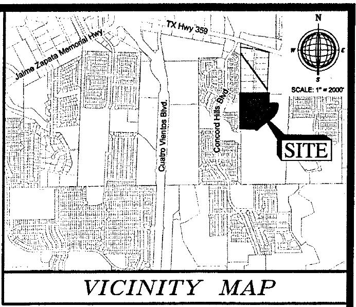
11 AGENDA ITEM: VIII-A DATE: 04/06/17 APPLICANT: AR Sanchez, Jr. ENGINEER: Crane Engineering REQUEST: Review and consideration of the Southern Development Subdivision Master Plan. The intent is residential and commercial. SITE: This acre tract is located south of State Highway 359 and east of Concord Hills Blvd. The zoning for this 326 lot development is M-1. This tract is located in District II- Cm. Vidal Rodriguez. PROPOSED ACTION: APPROVE SUBJECT TO THE FOLLOWING COMMENTS: Planning: 1. Submit master plan revision to City of Laredo Building Department GIS Division within 10 days of commission approval in a geo-referenced CAD file in accordance to Section 2-3.2(a) 4 of the City of Laredo Subdivision Ordinance. 2. Oil Patch Rd. is identified as a Local Collector. Residential lots are prohibited from having access from a Local Collector. 3. Identify tributary within the flood plain and stream order if possible. 4. All improvements as Per Subdivision Ordinance. Engineering: 1. Provide Detention Area. Fire: No comment submitted. Environmental: 1. Clarify where detention will occur for the development. Water & Utilities: No comments submitted. Traffic Safety: 1. Some intersections might have sight distance problems, check for sight distance. 2. Check sight distance of drive ways and curves. Parks & Leisure: 1. Park Improvement Fees will need to be paid prior to the recordation of each subdivision plat. WEBB County App: No comments submitted. AEP Engineers: No comments submitted. U.I.S.D.: No comments submitted. L.I.S.D.: No comments submitted. Page 1 of 2
12 AT&T: No comments submitted. NOTICE TO THE DEVELOPER: Planning: 1. Only the utility easements within the plat boundaries are subject to change prior to plat recordation, due to revisions by the utility companies. Page 2 of 2
13
14
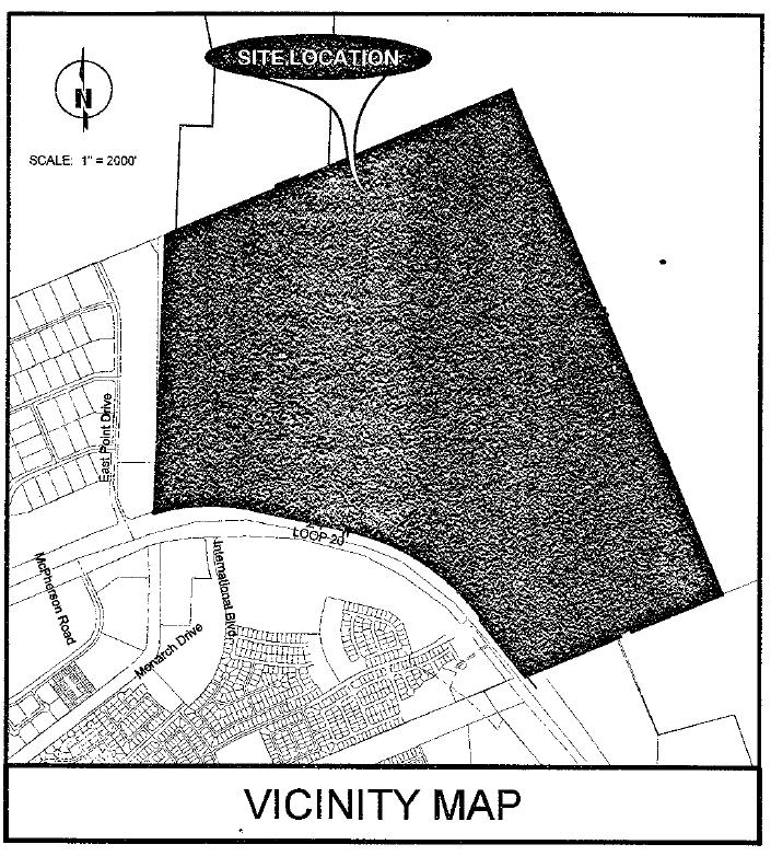
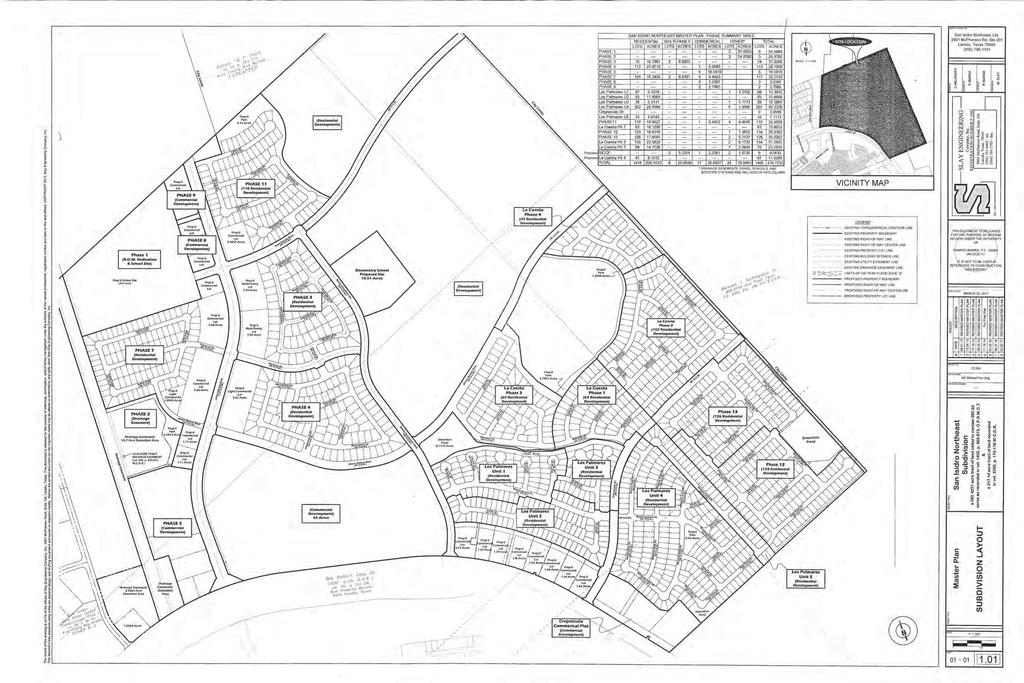
15 AGENDA ITEM: VIII-B DATE: 04/06/17 APPLICANT: San Isidro Northeast, Ltd ENGINEER: Slay Engineering Company, Inc. REQUEST: Review and consideration of the San Isidro Northeast Subdivision Master Plan. The intent is residential. SITE: This acre tract is located north of Bob Bullock Loop and east of East Point Drive. The zoning for this 1,465 lot development is R-1, R-2, B-1, B-3and B-4. This tract is located in District VI- Cm. Charlie San Miguel. PROPOSED ACTION: APPROVE SUBJECT TO THE FOLLOWING COMMENTS: Planning: 1. Submit master plan revision to City of Laredo Building Department GIS Division within 10 days in a geo-referenced CAD file in accordance to Section 2-3.2(a)4 of the City of Laredo Subdivision Ordinance. 2. Need to comply with Deferment Contract of the Parkland Dedication Ordinance in Section (4)a of the Laredo Land Development Code Book. 3. Provide City Limits on vicinity map. 4. Blank spaces (Proposed developments) within master plan must be identified and phase numbers placed. 5. All improvements as Per Subdivision Ordinance. Engineering: No comment submitted. Fire: No comments submitted. Environmental: No comments submitted. Water & Utilities: No comments submitted. Traffic Safety: 1. Some streets will need calming devices. 2. Check for sight distance at intersections with curves. Parks & Leisure: No comments submitted. WEBB County App: No comments submitted. AEP Engineers: No comments submitted. U.I.S.D.: No comments submitted. L.I.S.D.: No comments submitted. AT&T: No comments submitted. NOTICE TO THE DEVELOPER: Planning: 1. Only the utility easements within the plat boundaries are subject to change prior to plat recordation, due to revisions by the utility companies.
16
17
18 AGENDA ITEM: IX-A DATE: 04/06/17 APPLICANT: Mercado De Las Blancas, LLC ENGINEER: Ricardo Ramos, PE REQUEST: Preliminary consideration of the Plat of Mercado De Las Blancas. The intent is commercial. SITE: This 6.93 acre tract is located north of State Highway 359 and west of Camino Nuevo Rd. The zoning for this 1 lot development is B-4. This tract is located in District II- Cm. Vidal Rodriquez. PROPOSED ACTION: APPROVE SUBJECT TO THE FOLLOWING COMMENTS: Planning: 1. Provide plat note for GPS bearing for point of beginning and point of commencement. 2. Rename Location Map to Vicinity Map. 3. Provide City Limits on Vicinity Map. 4. Remove City of Laredo from Nathan Bratton signature block. 5. Revise Planning and Zoning chairman to Erasmo Villarreal Interim Chairman. 6. Revise plat note #4 to reflect new and current flood zone map with an effective date of April 2, Label all easements. 8. Remove all information regarding sanitary sewer, manholes, sewer lines, fire hydrant..etc. shown east of Camino Nuevo Road. 9. Lot 6, Block 2 does not appear to have access to a public R.O.W. Show how road was dedicated. 10. Clarify plat name: Mercado De Las Blancas Plat or Las Blancas Subdivision Unit 2, Lot 6, Block Provide Volume and Page number for this section of Camino Nuevo Rd. 12. Place signature blocks on the face of the plat in the following order: Owner w/ notary, Lien holder w/ notary (If applicable), Engineer of record and/or Surveyor, City Engineer, the Planning & Zoning Commission Chairman, Planning Director and the Webb County Clerk as the last three. 13. Remove contour lines. 14. All improvements as Per Subdivision Ordinance. Engineering: No comments submitted. Fire: No comment submitted. Environmental: No comments submitted. Water & Utilities: No comments submitted. Traffic Safety: No comments submitted. Parks & Leisure: No comments submitted. WEBB County App: No comments submitted. AEP Engineers: No comments submitted. U.I.S.D.: No comments submitted. Page 1 of 2
19 L.I.S.D.: No comments submitted. AT&T: No comments submitted. NOTICE TO THE DEVELOPER: Planning: 1. Only the utility easements within the plat boundaries are subject to change prior to plat recordation, due to revisions by the utility companies Page 2 of 2
20
21
22
23 AGENDA ITEM: IX-B DATE: 04/06/17 APPLICANT: Maximino Sanchez, Jr ENGINEER: TEC Engineering & Consultants, Inc. REQUEST: Preliminary consideration of the Plat of Old Milwaukee Subdivision Lots 18, 19, 20 and 21, Block 3. The intent is residential. SITE: This 0.69 acre tract is located south of State Highway 359 and east of Old Milwaukee Road.. This property is located outside the City Limits but within the Extra Territorial Jurisdiction (ETJ) of the City of Laredo. PROPOSED ACTION: APPROVE SUBJECT TO THE FOLLOWING COMMENTS: Planning: 1. Provide plat note for GPS bearing for point of beginning and point of commencement. 2. Rename Location Map to Vicinity Map. 3. Provide signature block for County Clerk s office. 4. Provide city limits on both subdivision plat and vicinity map. 5. Provide road name (Old Milwaukee Rd) and R.O.W. on plat. 6. Remove contour lines. 7. Label all easements. 8. Provide road name of Veterans Blvd. on Vicinity Map. 9. Place signature blocks on the face of the plat in the following order: Owner w/ notary, Lien holder w/ notary (If applicable), Engineer of record and/or Surveyor, City Engineer, the Planning & Zoning Commission Chairman, Planning Director and the Webb County Clerk as the last three. 10. Remove contour lines. 11. All improvements as Per Subdivision Ordinance. Engineering: No comments submitted. Fire: No comment submitted. Environmental: No comments submitted. Water & Utilities: No comments submitted. Traffic Safety: No comments submitted. Parks & Leisure: No comments submitted. WEBB County App: No comments submitted. AEP Engineers: No comments submitted. U.I.S.D.: No comments submitted. L.I.S.D.: No comments submitted. Page 1 of 2
24 AT&T: No comments submitted. NOTICE TO THE DEVELOPER: Planning: 1. Only the utility easements within the plat boundaries are subject to change prior to plat recordation, due to revisions by the utility companies Page 2 of 2
25
26
27
28 AGENDA ITEM: IX-C DATE: 04/06/17 APPLICANT: Kurt Kraus ENGINEER: Gilpin Engineering Co. REQUEST: Preliminary consideration of the Plat of Pinnacle Industrial Center Phase 2. The intent is industrial. SITE: This 38.0 acre tract is located west of FM 1472 and north of Vidal Cantu Road. The zoning for this 4 lot development is M-1. This tract is located in District VII- Cm. George Altgelt. PROPOSED ACTION: APPROVE SUBJECT TO THE FOLLOWING COMMENTS: Planning: 1. Provide plat note for GPS bearing for point of beginning and point of commencement. 2. Rename Location Map to Vicinity Map. 3. Provide city limits on Vicinity Map. 4. Remove City of Laredo from Nathan Bratton signature block. 5. Revise Planning and Zoning chairman to Erasmo Villarreal Interim Chairman. 6. Label West Peck Road on Subdivision plat. 7. Label all easements. 8. Remove contour lines. 9. All improvements as Per Subdivision Ordinance. Engineering: No comments submitted. Fire: No comment submitted. Environmental: No comments submitted. Water & Utilities: No comments submitted. Traffic Safety: No comments submitted. Parks & Leisure: No comments submitted. WEBB County App: No comments submitted. AEP Engineers: No comments submitted. U.I.S.D.: No comments submitted. L.I.S.D.: No comments submitted. AT&T: No comments submitted. Page 1 of 2
29 NOTICE TO THE DEVELOPER: Planning: 1. Only the utility easements within the plat boundaries are subject to change prior to plat recordation, due to revisions by the utility companies Page 2 of 2
30
31
32
33 AGENDA ITEM:IX-D DATE: 04/06/17 APPLICANT: Fransisco Urbina ENGINEER: Howland Engineering & Surveying Co. REQUEST: Preliminary consideration of the replat of Lot 26, Block 1, Cuatro Vientos Norte Subdivision Phase III into Lots 26A, 26B, 26C, 26D, 26E & 26F, Block 1, Cuatro Vientos Norte Subdivision Phase III. The intent is residential. The purpose of the replat is to create six lots out of one lot. SITE: This 1.58 acre tract is located north of Wormser Road and east of Mexico Avenue. The zoning for this 6 lot development is R-1A. This tract is located in District I- Cm. Rudy Gonzalez, Jr. PROPOSED ACTION: APPROVE SUBJECT TO THE FOLLOWING COMMENTS: Planning: 1. Provide plat note for GPS bearing for point of beginning and point of commencement. 2. Remove City of Laredo from Nathan Bratton signature block. 3. Revise Planning and Zoning chairman to Erasmo Villarreal Interim Chairman. 4. Provide a lot summary table. 5. Will have to comply with Parkland requirements. If Park Improvement Fees are due, they will need to be paid prior to recordation. 6. Place signature blocks on the face of the plat in the following order: Owner w/ notary, Lien holder w/ notary (If applicable), Engineer of record and/or Surveyor, City Engineer, the Planning & Zoning Commission Chairman, Planning Director and the Webb County Clerk as the last three. 7. Provide a note on the face of the plat stating, All curb cuts shall comply with the Transportation Element of the City of Laredo Comprehensive Plan. 8. Add exiting notes from approved plat to the replat. 9. All improvements as Per Subdivision Ordinance. Engineering: No comments submitted. Fire: No comment submitted. Environmental: No comments submitted. Water & Utilities: No comments submitted. Traffic Safety: No comments submitted. Parks & Leisure: 1. Parkland requirements will be filled by developer at different location. WEBB County App: No comments submitted. AEP Engineers: No comments submitted. U.I.S.D.: No comments submitted. L.I.S.D.: No comments submitted. Page 1 of 2
34 AT&T: No comments submitted. NOTICE TO THE DEVELOPER: Planning: 1. Only the utility easements within the plat boundaries are subject to change prior to plat recordation, due to revisions by the utility companies Page 2 of 2
35
36
37
38 AGENDA ITEM: IX-E DATE: 04/06/17 APPLICANT: 6414 Cresent Loop, LP ENGINEER: Ricardo Ramos, PE REQUEST: Preliminary consideration of the replat of Lot 5A, Block 2, Laredo Arena Subdivision Unit 1 into Lots 5A-1 & 5A-2, Block 2, Laredo Arena Subdivision Unit 1. The intent is commercial. The purpose of the replat is to create two lots out of one lot. SITE: This 6.93 acre tract is located west of Bob Bullock Loop (Loop 20) and south of Jacaman Road. The zoning for this 2 lot development is B-4. This tract is located in District V- Cm. Norma Nelly Vielma. PROPOSED ACTION: APPROVE SUBJECT TO THE FOLLOWING COMMENTS: Planning: 1. Provide plat note for GPS bearing for point of beginning and point of commencement. 2. Rename Location Map to Vicinity Map. 3. Remove City of Laredo from Nathan Bratton signature block. 4. Revise Planning and Zoning chairman to Erasmo Villarreal Interim Chairman. 5. Place signature blocks on the face of the plat in the following order: Owner w/ notary, Lien holder w/ notary (If applicable), Engineer of record and/or Surveyor, City Engineer, the Planning & Zoning Commission Chairman, Planning Director and the Webb County Clerk as the last three. 6. Provide a note on the face of the plat stating, All curb cuts shall comply with the Transportation Element of the City of Laredo Comprehensive Plan. 7. Provide a plat note stating Lot 5A-2 will be prohibited from have access to Crescent Loop. 8. Add exiting notes from approved plat to the replat. 9. All improvements as Per Subdivision Ordinance. Engineering: No comments submitted. Fire: No comment submitted. Environmental: No comments submitted. Water & Utilities: No comments submitted. Traffic Safety: No comments submitted. Parks & Leisure: No comments submitted. WEBB County App: No comments submitted. AEP Engineers: No comments submitted. U.I.S.D.: No comments submitted. L.I.S.D.: No comments submitted. Page 1 of 2
39 AT&T: No comments submitted. NOTICE TO THE DEVELOPER: Planning: 1. Only the utility easements within the plat boundaries are subject to change prior to plat recordation, due to revisions by the utility companies Page 2 of 2
40
41
42
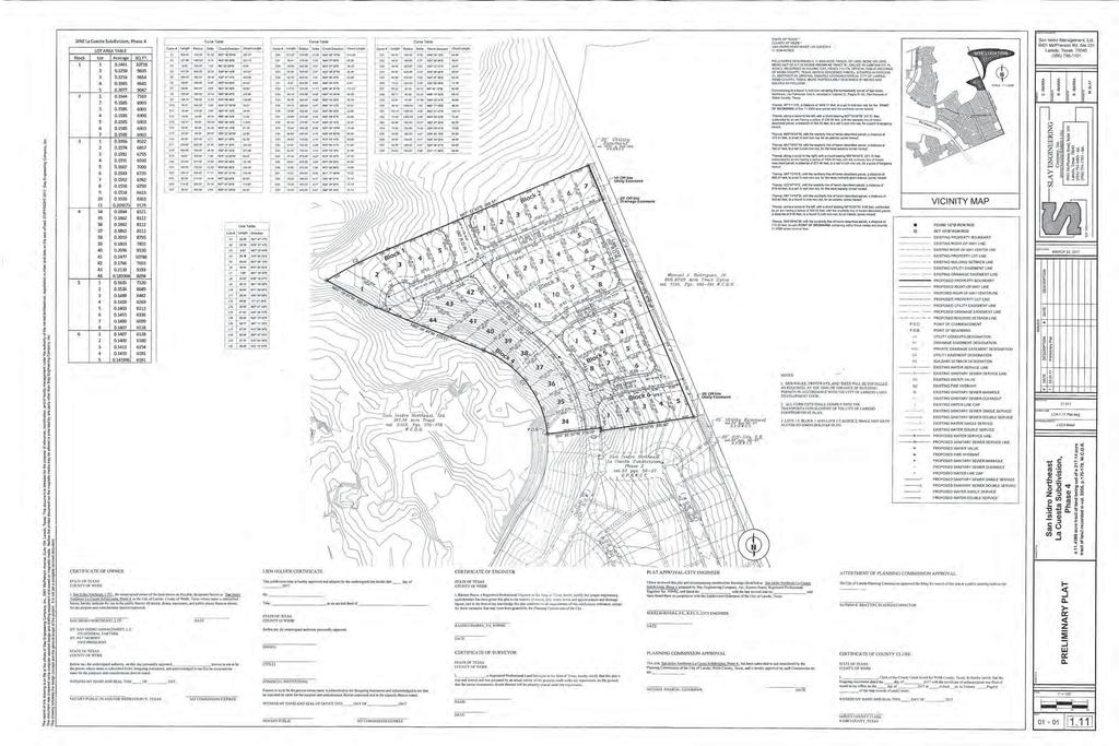
43 AGENDA ITEM:IX-F DATE: 04/06/17 APPLICANT: San Isidro Northeast, Ltd ENGINEER: Slay Engineering Company, Inc. REQUEST: Preliminary consideration of the Plat of San Isidro Northeast La Cuesta Subdivision Phase 4. The intent is residential. SITE: This acre tract is located north of Bob Bullock Loop (Loop 20) and east of Bucky Houdmann Blvd. The zoning for this 47 lot development is R-1. This tract is located in District VI- Cm. Charlie San Miguel. PROPOSED ACTION: APPROVE SUBJECT TO THE FOLLOWING COMMENTS: Planning: 1. Provide plat note for GPS bearing for point of beginning and point of commencement. 2. Revise Planning and Zoning chairman to Erasmo Villarreal Interim Chairman. 3. Label all easements. 4. Provide lot summary table. 5. Place signature blocks on the face of the plat in the following order: Owner w/ notary, Lien holder w/ notary (If applicable), Engineer of record and/or Surveyor, City Engineer, the Planning & Zoning Commission Chairman, Planning Director and the Webb County Clerk as the last three. 6. Remove contour lines. 7. All improvements as Per Subdivision Ordinance. Engineering: No comment submitted. Fire: No comment submitted. Environmental: No comments submitted. Water & Utilities: No comments submitted. Traffic Safety: 1. Some streets will need calming devices. 2. Check for sight distance at intersections with curve. Parks & Leisure: 1. Master plan has been reviewed and parkland dedication was recommended, approved by Parks Board. WEBB County App: No comments submitted. AEP Engineers: No comments submitted. U.I.S.D.: No comments submitted. L.I.S.D.: No comments submitted. Page 1 of 2
44 AT&T: No comments submitted. NOTICE TO THE DEVELOPER: Planning: 1. Only the utility easements within the plat boundaries are subject to change prior to plat recordation, due to revisions by the utility companies Page 2 of 2
45
46
47
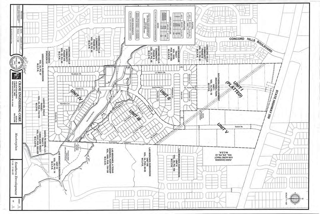
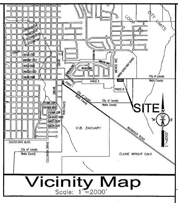
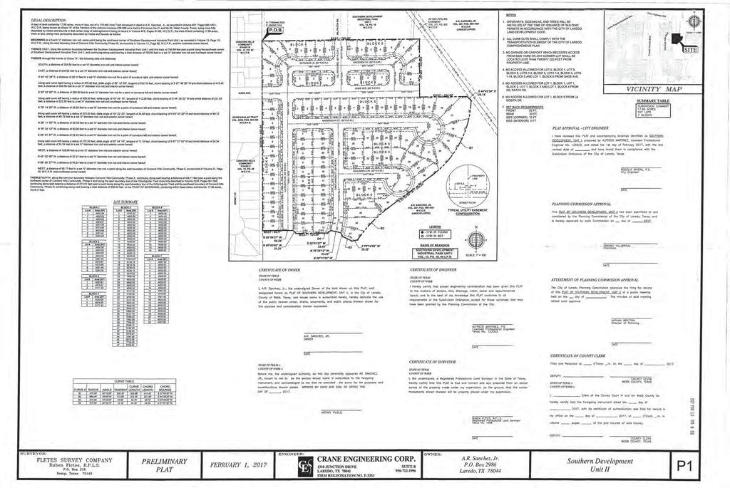
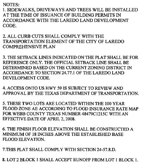
48 AGENDA ITEM: IX-G DATE: 04/06/17 APPLICANT: AR Sanchez, Jr. ENGINEER: Crane Engineering REQUEST: Preliminary consideration of the Plat of Southern Development Subdivision Unit II. The intent is residential. SITE: This acre tract is located south of State Highway 359 and east of Concord Hills Blvd. The zoning for this 104 lot development is M-1. This tract is located in District II- Cm. Vidal Rodriguez. PROPOSED ACTION: APPROVE SUBJECT TO THE FOLLOWING COMMENTS: Planning: 1. Prove plat note for GPS point of beginning and point of commencement bearing. 2. Please clarify plat note #5 and #6. 3. Revise Planning and Zoning Chairman to Erasmo Villarreal Interim Chairman. 4. Need to provide written notice of the developer s intention to place front of lot utility as per Section 3-4 (2) of the Subdivision Ordinance Handbook. 5. Lots must meet minimum frontage requirements as follows: The minimum lot width shall be measured at the front building setback line. In no event shall the lot width at the property line be less than twenty-four feet (Laredo Land Development Code Book section ) 6. All improvements as Per Subdivision Ordinance. Engineering: Fire: 1. Identify all easements. 1. Must provide for temporary turnaround at the end of La Rosita Dr. and Santuarios St. Environmental: No comment submitted. Water & Utilities: No comments submitted. Traffic Safety: No comments submitted. Parks & Leisure: 1. Park Improvement Fees should be paid prior to recordation of plat. WEBB County App: No comments submitted. AEP Engineers: No comments submitted. U.I.S.D.: No comments submitted. L.I.S.D.: No comments submitted. Page 1 of 2
49 AT&T: No comments submitted. NOTICE TO THE DEVELOPER: Planning: 1. Only the utility easements within the plat boundaries are subject to change prior to plat recordation, due to revisions by the utility companies. 2. A re-zone will be required for intended use. Page 2 of 2
50
51
52
53 AGENDA ITEM: IX-H DATE: 04/06/17 APPLICANT: KRK Limited ENGINEER: Peua Consulting LLC REQUEST: Preliminary consideration of the Plat of The Reserve Subdivision Phase IA. The intent is residential. SITE: This 3.87 acre tract is located north of Del Mark Blvd. and west of Winfield Parkway. The zoning for this 18 lot development is R-1. This tract is located in District VI- Cm. Charlie San Miguel. PROPOSED ACTION: APPROVE SUBJECT TO THE FOLLOWING COMMENTS: Planning: 1. Provide plat note for GPS bearing for point of beginning and point of commencement. 2. Please revise vicinity map sale to 1 =2, Revise Planning and Zoning chairman to Erasmo Villarreal Interim Chairman. 4. Remove plat note #4 and review Plat notes #5, #6, #7 and #8. 5. Provide and label all easements. 6. Please indicate Phase or Unit. 7. Place signature blocks on the face of the plat in the following order: Owner w/ notary, Lien holder w/ notary (If applicable), Engineer of record and/or Surveyor, City Engineer, the Planning & Zoning Commission Chairman, Planning Director and the Webb County Clerk as the last three. 8. Provide darker fonts for Block number. 9. Will need to comply with Parkland requirements. If Park Improvements are due, they will need to be paid prior to recordation. 10. Provide Volume and Page number to Release of Oil and Gas easement to be abandoned. 11. On Inset A provide Lot #, Block # and Phase # to the property east of Lot 6, Block All improvements as Per Subdivision Ordinance. Engineering: No comment submitted. Fire: No comment submitted. Environmental: No comments submitted. Water & Utilities: No comments submitted. Traffic Safety: No comment submitted. Parks & Leisure: No comments submitted. WEBB County App: No comments submitted. AEP Engineers: No comments submitted. U.I.S.D.: No comments submitted. L.I.S.D.: No comments submitted. AT&T: No comments submitted. Page 1 of 2
54 NOTICE TO THE DEVELOPER: Planning: 1. Only the utility easements within the plat boundaries are subject to change prior to plat recordation, due to revisions by the utility companies Page 2 of 2
55
56
57
58 AGENDA ITEM: X-A DATE: 04/06/17 APPLICANT: Jose Luis Palos ENGINEER: Howland Engineering & Surveying Co. REQUEST: Public hearing and preliminary consideration of the replat of Lots 13 & 14, Block 1, El Dorado Estates Subdivision into Lots 13A & 14A, Block 1, El Dorado Estates Subdivision. The intent is residential. The purpose of the replat is to reconfigure 2 lots. SITE: This.054 acre tract is located north of Jacaman Road. and west of Casa Verde Road. The zoning for this 2 lot development is R-1. This tract is located in District V- Cm. Norma Nelly Vielma. PROPOSED ACTION: APPROVE SUBJECT TO THE FOLLOWING COMMENTS: Planning: 1. Provide plat note for GPS bearing for point of beginning and point of commencement. 2. Rename Location Map to Vicinity Map. 3. Rename El Dorado Loop to Palos Loop. 4. Provide Plat note stating Lot 14A, Block 1, will be prohibited from having access onto Casa Verde Road. 5. Provide a note on the face of the plat stating, All curb cuts shall comply with the Transportation Element of the City of Laredo Comprehensive Plan. 6. Provide a note on the face of the plat stating, Sidewalks and trees will be installed at the time of issuance of building permits in accordance with the Laredo Land Development Code. 7. Remove Contour Lines. 8. Provide a note on the face of the replat stating, This replat does not attempt to alter, amend, or remove any restrictions or covenants. 9. Provide plat notes from As Platted that may be needed on replat. 10. All improvements as Per Subdivision Ordinance. Engineering: 1. Show all existing and necessary easements. Fire: No comment submitted. Environmental: No comments submitted. Water & Utilities: No comments submitted. Traffic Safety: No comments submitted. Parks & Leisure: No comments submitted. WEBB County App: No comments submitted. AEP Engineers: No comments submitted. U.I.S.D.: No comments submitted. Page 1 of 2
59 L.I.S.D.: No comments submitted. AT&T: No comments submitted. NOTICE TO THE DEVELOPER: Planning: 1. Only the utility easements within the plat boundaries are subject to change prior to plat recordation, due to revisions by the utility companies Page 2 of 2
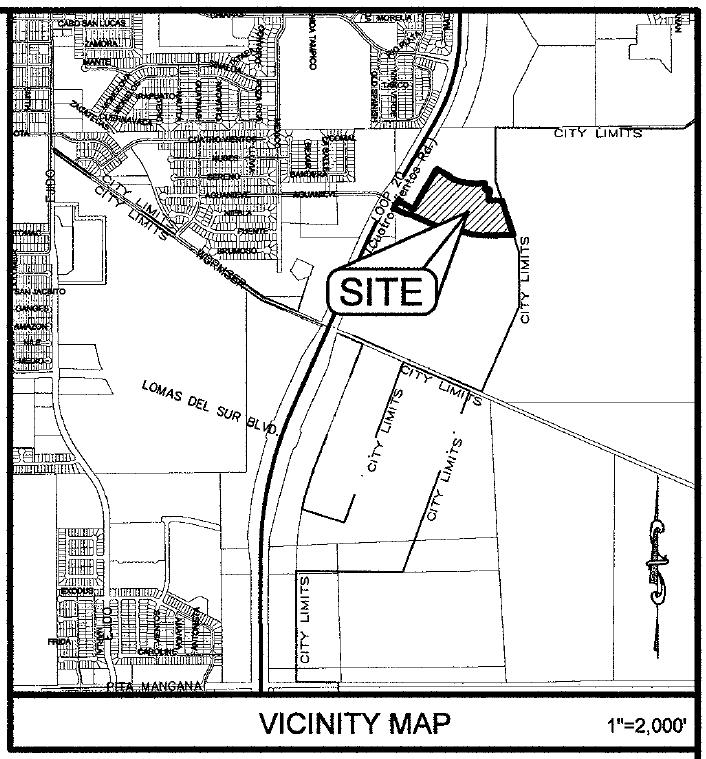
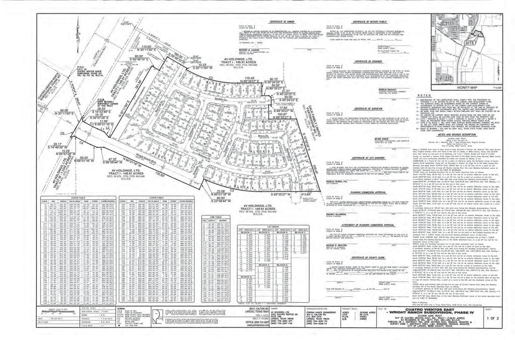
60
61
62
63 AGENDA ITEM: XI-A DATE: 04/06/17 APPLICANT: 4V Holdings, Ltd ENGINEER: Porras Nance Engineering REQUEST: Final consideration of the Plat of Cuatro Vientos East Wright Ranch Subdivision Phase IV. The intent is residential. SITE: This acre tract is located south of State Highway 359 and east of Cuatro Vientos Rd. The zoning for this 96 lot development is R-1A. This tract is located in District II- Vidal Rodriguez. PREVIOUS COMMISSION ACTION: This item was granted preliminary plat approval by the Planning & Zoning Commission on 11/17/2016. PROPOSED ACTION: APPROVAL
64
65
66
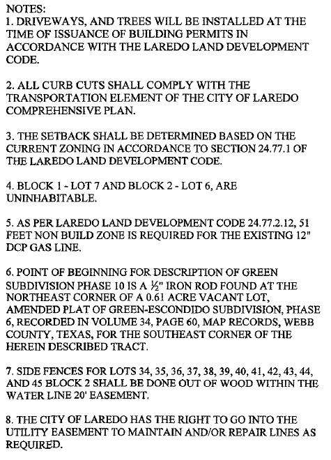
67 AGENDA ITEM: XI-B DATE: 04/06/17 APPLICANT: WW Escondido ENGINEER: Peua Consulting, LLC REQUEST: Final consideration of the Plat of Green Subdivision Phase 10. The intent is residential. SITE: This 17.5 acre tract is located north of F.M and east of People s Blvd. The zoning for this 120 lot development is R-1MH. This tract is located in District VII- Cm. George Altgelt. PREVIOUS COMMISSION ACTION: This item was granted preliminary plat approval by the Planning & Zoning Commission on 12/01/2016. PROPOSED ACTION: APPROVAL
68
69
70 30' OFF-SITE D.E. 30' OFF-SITE D.E ' 20' B.S. C119 C94 C95 CERTIFICATE OF OWNER STATE OF TEXAS COUNTY OF WEBB I, the undersigned owner of the land shown on this plat, designated herein as Green Subdivision Phase 10, in the City of Laredo, County of Webb, Texas whose name is subscribed hereto, hereby dedicate the use to the public forever all streets, drains, easements, and public places thereon shown, for the purpose and consideration therein expressed. DATE STATE OF TEXAS COUNTY OF WEBB Before me, the undersigned authority, on this day personally appeared,, known to me to be the person whose name is subscribed to the foregoing instrument, and acknowledged to me that he executed the same for the purposes and considerations therein stated. WITNESS MY HAND AND SEAL THIS OF, NOTARY PUBLIC IN AND FOR WEBB COUNTY, TEXAS MY COMMISSION EXPIRES LIEN HOLDER CERTIFICATE This subdivision map is hereby approved and adopted by the undersigned lien holder this day of, By: Title:, as an act and deed of. STATE OF TEXAS COUNTY OF WEBB Before me, the undersigned authority personally appeared. (NAME) (TITLE) (FINANCIAL INSTITUTION) Known to me to be the person whose name is subscribed to the foregoing instrument and acknowledged to me that he executed the same for the purpose and consideration therein expressed and in the capacity therein stated. WITNESS MY HAND AND SEAL OF OFFICE THIS DAY OF, NOTARY PUBLIC MY COMMISSION EXPIRES CERTIFICATE OF ENGINEER STATE OF TEXAS COUNTY OF WEBB I, Oscar Castillo, a Registered Professional Engineer in the State of Texas, hereby certify that proper engineering consideration has been given this plat to the matters of streets, lots, water, sewer and appurtenances and drainage layout; and to the best of my knowledge this plat conforms to all requirements of this subdivision ordinance, except for those variances that may have been granted by the Planning Commission of the City. OSCAR CASTILLO, P.E. #95620 DATE CERTIFICATE OF SURVEYOR STATE OF TEXAS COUNTY OF WEBB I,, a Registered Professional Land Surveyor in the State of Texas, hereby certify that this plat is true and correct and was prepared by an actual survey of the property made under my supervision, on the ground, that the corner monuments shown thereon will be properly placed under my supervision. NAME DATE L25 L24 N22 39' 01"W ' ' ' 15' OFF-SITE U.E. - 2 L26 S67 20' 59"W 30.00' S22 39' 01"E ' L23 20' OFF-SITE D.E. - 2 N55 36' 15"E ' 20.43' S56 26' 56"W ' 21.34' 20.39' L27 Point of Beginning L10 ' (15' Off-Site U.E. - 1) 51.0' Point of S67 20' 59"W 24.32' S55 36' 15"W ' N56 26' 56"E ' Point of Beginning Point of 51' NON- BUILDABLE ZONE Beginning Beginning 20.48' L ' S36 09' 49"E S38 13' 59"E S39 16' 14"E S38 23' 34"E S37 27' 28"E S40 18' 28"E C75 C76 C77 C78 C ' (20' Off-Site D.E. - 2) Point of N46 58' 19"E ' Beginning L8 C ' S46 58' 19"W ' (20' Off-Site D.E. - 3) S56 07' 30"W ' Point of N56 07' 30"E ' Beginning (30' Off-Site D.E. - 1) (15' Off-Site U.E. - 2) PLAT SCALE: 1" = 100' 15' OFF-SITE U.E ' OFF-SITE D.E. - 3 C4 ' C27 C14 N57 08' 13"E ' S57 08' 13"W ' (20' Off-Site D.E. - 4) L7 C73 C28 ' L6 C72 L5 ' C71 S39 23' 28"E S38 24' 00"E ' L4 L3 S37 50' 20"E ' S41 20' 42"E C70 S39 20' 16"E S37 45' 48"E S38 44' 51"E S42 22' 56"E 20' B.S. C13 C237 C238 C239 C240 C ' 20.57' S37 23' 39"E 40.62' C236 C ' C227 20' OFF-SITE D.E ' OFF-SITE U.E. - 2 S37 22' 37"E C S40 23' 23"E S39 19' 01"E S38 36' 18"E 20' B.S. S39 39' 19"E S38 11' 33"E S43 25' 11"E S41 11' 54"E S42 23' 14"E S39 26' 48"E S40 33' 18"E S44 27' 25"E S39 00' 30"E S42 08' 13"E S40 16' 55"E S43 23' 09"E S41 28' 18"E S45 29' 47"E C80 C81 C82 C83 C84 C69 C26 C16 S43 05' 00"E 20' B.S. S39 49' 27"E S41 07' 39"E S44 23' 04"E C212 C213 C32 C18 C36 C29 C68 C37 C67 C65 C66 C33 C195 C196 C197 C198 C199 C ' 10.38' 5.04' C235 C226 C194 C170 C171 C172 C173 C174 C ' C169 C142 6' U.E. S40 23' 23"E C234 C225 C193 C233 C224 6' U.E. C168 C141 C140 C139 C138 S42 22' 57"E S41 15' 03"E C12 S45 22' 59"E S44 01' 08"E 20' B.S. S40 38' 24"E C64 C63 C25 C31 S41 58' 24"E C C17 C85 C62 C24 C30 S43 17' 56"E 60' R S44 56' 56"E S42 49' 57"E 20' B.S. C136 20' B.S. S41 27' 20"E C S7 05' 22"E C61 C23 S45 53' 08"E S44 11' 51"E S42 16' 17"E C1 L ' 40.32' ' B.S. S43 40' 32"E 42.00' 42.00' 47.55' L11 S17 21' 55"W C60 S45 06' 21"E S44 31' 54"E ' S43 05' 14"E 14.55' 10' B.S. S28 36' 28"W 42.00' S61 23' 32"E ' C135 C143 C144 C145 C146 C147 C148 C ' C242 C243 C244 C245 C246C247 C192 C232 C223 C167 C191 C166 C231 C222 C190 6' U.E. C165 PLAT APPROVAL-CITY ENGINEER C230 C221 PLANNING COMMISSION APPROVAL 6' U.E. C189 C164 C229 C220 C188 C219 C ' C228 C187 C218 C214 C215 C216 C217 C162 C106 C105 C107 S46 00' 43"E S45 22' 51"E S46 55' 22"E S46 13' 25"E S47 04' 30"E 10' B.S. S66 38' 15"W 20' B.S S73 36' 18"W S77 20' 18"W S81 04' 18"W S84 48' 19"W S88 32' 19"W S87 43' 41"E S87 14' 03"E S86 28' 51"W S86 28' 51"W S82 11' 44"W S67 14' 13"W S67 14' 13"W S67 14' 13"W S67 14' 13"W ' 42.00' 42.00' 42.00' 42.00' 42.00' 28.28' S28 36' 28"W 42.00' S43 54' 11"E N61 23' 32"W ' S61 23' 32"E ' C ' C161 C134 C35 C15 C108 C185 L18 C38 C133 C109 C128 S28 36' 28"W 42.00' C201 C202 C203 C204 C205 C206 C S44 43' 07"E C2 C110 C ' 42.00' 42.00' 42.00' 25.13' S22 44' 15"E ' L ' 17.77' C127 C126 L19 C184 C176 C177 C178 C179 C180 C181 6' U.E ' C159 C132 C40 S28 36' 28"W C112 C C114 C115 L12 S28 36' 28"W 42.00' C ' S45 32' 04"E C ' C19 N22 44' 15"W ' N22 44' 15"W ' 27.47' 45.04' 44.99' 50.00' L S28 36' 28"W 17.41' 22.69' S55 35' 48"E 79.95' C183 C182 C158 C ' S45 45' 14"E 30.65' 48.12' S5 14' 47"W ' C41 L17 C42 C34 C117 C130 C125 S34 24' 12"W ' B.S. S39 00' 50"W 10' B.S S42 17' 23"W S45 33' 57"W S49 28' 42"W S49 28' 42"W 20' B.S S55 23' 57"W S58 40' 33"W S61 57' 10"W S65 13' 47"W S68 30' 24"W S71 47' 02"W S75 03' 41"W S78 20' 19"W S81 36' 59"W S84 53' 38"W S88 10' 19"W S88 09' 07"E S89 04' 36"W S86 28' 51"W S86 28' 51"W S67 14' 44"W S67 14' 44"W S67 15' 45"W S67 09' 12"W N67 09' 16"E ' L ' S34 24' 12"W 22.51' C11 C ' 54.30' 54.30' N5 14' 47"E ' N5 14' 47"E ' 25.48' 10.92' C118 C124 C59 C123 C58 L21 C150 C151 C152 C153 C154 C155 6' U.E S67 09' 16"W ' U.E. 50.0' C ' C157 C ' U.E C57 S40 31' 18"E 82.27' C ' N40 31' 18"W 83.75' C120 C121 S67 09' 16"W I have reviewed this plat and accompanying construction drawings identified as Green Subdivision Phase 10, prepared by PEUA Consulting LLC., Oscar Castillo, Registered Professional Engineer No , and dated the with the last revised date on and have found them in compliance with the Subdivision Ordinance of the City of Laredo, Texas. ROGELIO RIVERA, P.E., R.P.L.S., CITY ENGINEER DATE This plat, Green Subdivision Phase 10, has been submitted to and considered by the Planning Commission of the City of Laredo, Webb County, Texas, and is hereby approved by such Commission on the. ERASMO VILLAREAL - INTERIM CHAIRMAN C ' 50.00' 45.03' L ' 25.46' C ' L ' 60.00' 42.00' 33.73' C43 C44 C104 C56 C53 C54 C10 C20 DATE C51 C52 C47 C48 C45 C46 C86 C ' C49 C50 6' U.E. C103 L15 C ' 45.00' C88 C89 C ' 42.00' 11.14' C101 L14 C100 C ' C92 C99 C93 C98 C96 C97 C7 LEGAL DESCRIPTION GREEN-ESCONDIDO PHASE 10 Being a Acre tract of land out of a tract conveyed by deed to WW Escondido, L.P., recorded in Volume 3708, Pages , Official Public Records, Webb County, Texas, and being more particularly described by metes and bounds as follows: BEGINNING at a ½ iron rod found at the northeast corner of a 0.61 Acre Vacant Lot, Amended Plat of Green-Escondido Subdivision, Phase 6, recorded in Volume 34, Page 60, Map Records, Webb County, Texas, for the southeast corner of the herein described tract; Thence, along the north boundary line of said Vacant Lot and Lot 1, Block 3 of said Amended Plat of Green-Escondido Subdivision, Phase 6, South 67 degrees 09 minutes 16 seconds West, feet, to a ½ iron rod found at the southeast corner of a previously surveyed 6.88 acre tract of land, out of a tract conveyed by deed to WW Escondido, L.P., recorded in Volume 3708, Pages , on the north boundary line of Green-Escondido Subdivision, Phase 6, recorded in Volume 33, Pages 68-69, Map Records, Webb County, Texas, for the most southerly southwest corner of the herein described tract; Thence, along the east boundary line of said 6.88 acre tract, the following courses and distances; North 22 degrees 50 minutes 44 seconds West, feet, to a ½ iron rod found at a point of curvature to the right of the herein described tract; Thence, along the arc of the curve right a distance of feet, said curve having a radius of feet, a delta of 33 degrees 40 minutes 45 seconds, with a chord and chord bearing of feet and North 06 degrees 00 minutes 22 seconds West, to a ½ iron rod found at a point of curvature to the left of the herein described tract; Thence, along the arc of the curve left a distance of feet, said curve having a radius of feet, a delta of 32 degrees 31 minutes 17 seconds, with a chord and chord bearing of feet and North 05 degrees 25 minutes 38 seconds West, to a ½ iron rod found at the northeast corner of said 6.88 acre tract, a non-tangent curve to the right of the herein described tract; Thence, along the arc of the curve right and north boundary line of said 6.88 acre tract, a distance of feet, said curve having a radius of 3, feet, a delta of 08 degrees 26 minutes 30 seconds, with a chord and chord bearing of feet and South 49 degrees 12 minutes 12 seconds West, to a ½ iron rod set at a non-tangent point of the herein described tract; Thence, North 36 degrees 33 minutes 40 seconds West, feet, to a ½ iron rod set, for a point of deflection of the herein described tract; Thence, North 16 degrees 39 minutes 38 seconds West, feet, to a ½ iron rod set, for a point of deflection of the herein described tract; Thence, North 36 degrees 55 minutes 50 seconds West, feet, to a ½ iron rod set, for a point of deflection of the herein described tract; Thence, North 56 degrees 14 minutes 28 seconds West, feet, to a ½ iron rod set, for a point of deflection of the herein described tract; Thence, North 36 degrees 34 minutes 02 seconds West, feet, to a ½ iron rod set at a non-tangent point of curvature to the right of the herein described tract; Thence, along the arc of the curve right a distance of 7.53 feet, said curve having a radius of 2, feet, a delta of 00 degrees 10 minutes 21 seconds, with a chord and chord bearing of 7.53 feet and South 53 degrees 31 minutes 55 seconds West, to a ½ iron rod set, for an exterior corner of the herein described tract; Thence, North 36 degrees 23 minutes 44 seconds West, feet, to a ½ iron rod set, for a point of deflection of the herein described tract; Thence, North 46 degrees 48 minutes 50 seconds West, feet, to a ½ iron rod set, for a point of deflection of the herein described tract; Thence, North 36 degrees 09 minutes 36 seconds West, feet, to a ½ iron rod set at a non-tangent curve to the left, the south boundary line of N.D. Hachar Trust, recorded in Volume 166, Pages , Deed Records, Webb County, Texas, for the northwest corner of the herein described tract; Thence, along the arc of the curve left and south boundary line of said Hachar Tract, a distance of feet, said curve having a radius of 2, feet, a delta of 13 degrees 34 minutes 53 seconds, with a chord and chord bearing of feet and North 47 degrees 03 minutes 15 seconds East, to a ½ iron rod set on the west boundary line of said Hachar Tract, for the most northerly northeast corner of the herein described tract; Thence, along the west boundary line of said Hachar Tract, the following courses and distances; South 49 degrees 37 minutes 14 seconds East, feet, to a ½ iron rod set, for a point of deflection of the herein described tract; South 61 degrees 23 minutes 32 seconds East, feet, to a ½ iron rod set, for a point of deflection of the herein described tract; South 55 degrees 35 minutes 48 seconds East, feet, to a ½ iron rod set at a point of curvature to the right of the herein described tract; Thence, along the arc of the curve right a distance of feet, said curve having a radius of feet, a delta of 08 degrees 59 minutes 51 seconds, with a chord and chord bearing of feet and South 48 degrees 08 minutes 50 seconds East, to a ½ iron rod set at a tangent point of the herein described tract; South 40 degrees 31 minutes 18 seconds East, feet, to a ½ iron rod set at a point of curvature to the right of the herein described tract; Thence, along the arc of the curve right a distance of feet, said curve having a radius of feet, a delta of 39 degrees 30 minutes 52 seconds, with a chord and chord bearing of feet and South 17 degrees 38 minutes 15 seconds East, to a ½ iron rod set at a tangent point of the herein described tract; South 05 degrees 14 minutes 47 seconds West, feet, to a ½ iron rod set at a point of curvature to the right of the herein described tract; Thence, along the arc of the curve right a distance of feet, said curve having a radius of 5, feet, a delta of 00 degrees 36 minutes 23 seconds, with a chord and chord bearing of feet and South 10 degrees 33 minutes 05 seconds West, to a ½ iron rod set at a non-tangent point of the herein described tract; Thence, South 22 degrees 44 minutes 15 seconds East, a distance of feet, to return and close to the POINT OF BEGINNING of this Acre Tract, more or less. Basis of Bearings: G.P.S., Texas Coordinate System., Texas South Zone, (NAD 1983) ATTESTMENT OF PLANNING COMMISSION APPROVAL The City of Laredo Planning Commission approved the filing for record of this plat at a public meeting held on the. NATHAN R. BRATTON, PLANNING DIRECTOR CERTIFICATE OF COUNTY CLERK STATE OF TEXAS COUNTY OF WEBB I,, Clerk of the County Court in and for Webb County, Texas, do hereby certify that the foregoing instrument dated the day of 2017 with the certificate of authentication was filed of record in my office on the day of, 2017 at o'clock.m. in Volume, Page(s) of the map records of said County. WITNESS MY HAND AND SEAL THIS DAY OF, DEPUTY COUNTY CLERK WEBB COUNTY, TEXAS 2 - PLAT LOCATION Verde Blvd Laredo City Limits Green Ranch Aransas Pass Dr Mines Road Port Edward Ave Peoples Blvd Port San Angelo Dr VICINITY MAP SCALE: 1" = 2000' NOTES: 1. DRIVEWAYS, AND TREES WILL BE INSTALLED AT THE TIME OF ISSUANCE OF BUILDING PERMITS IN ACCORDANCE WITH THE LAREDO LAND DEVELOPMENT CODE. 2. ALL CURB CUTS SHALL COMPLY WITH THE TRANSPORTATION ELEMENT OF THE CITY OF LAREDO COMPREHENSIVE PLAN. 3. THE SETBACK SHALL BE DETERMINED BASED ON THE CURRENT ZONING IN ACCORDANCE TO SECTION OF THE LAREDO LAND DEVELOPMENT CODE. 4. BLOCK 1 - LOT 7 AND BLOCK 2 - LOT 6, ARE UNINHABITABLE. 5. AS PER LAREDO LAND DEVELOPMENT CODE , 51 FEET NON BUILD ZONE IS REQUIRED FOR THE EXISTING 12" DCP GAS LINE. 6. POINT OF BEGINNING FOR DESCRIPTION OF GREEN SUBDIVISION PHASE 10 IS A 1 2" IRON ROD FOUND AT THE NORTHEAST CORNER OF A 0.61 ACRE VACANT LOT, AMENDED PLAT OF GREEN-ESCONDIDO SUBDIVISION, PHASE 6, RECORDED IN VOLUME 34, PAGE 60, MAP RECORDS, WEBB COUNTY, TEXAS, FOR THE SOUTHEAST CORNER OF THE HEREIN DESCRIBED TRACT. 7. SIDE FENCES FOR LOTS 34, 35, 36, 37, 38, 39, 40, 41, 42, 43, 44, AND 45 BLOCK 2 SHALL BE DONE OUT OF WOOD WITHIN THE WATER LINE 20' EASEMENT. 8. THE CITY OF LAREDO HAS THE RIGHT TO GO INTO THE UTILITY EASEMENT TO MAINTAIN AND/OR REPAIR LINES AS REQUIRED. D.E. U.E. B.S. Ann Harbor FOUND 1/2"Ø IRON ROD SET 1/2"Ø IRON ROD EXISTING PROPERTY BOUNDARY EXISTING RIGHT-OF-WAY LINE EXISTING RIGHT-OF-WAY CENTER LINE EXISTING PROPERTY LOT LINE Laredo City Limits EXISTING BUILDING SETBACK LINE EXISTING UTILITY EASEMENT LINE EXISTING DRAINAGE EASEMENT LINE PROPOSED PROPERTY BOUNDARY PROPOSED RIGHT-OF-WAY LINE PROPOSED RIGHT-OF-WAY CENTERLINE PROPOSED PROPERTY LOT LINE PROPOSED UTILITY EASEMENT LINE PROPOSED DRAINAGE EASEMENT LINE PROPOSED BUILDING SETBACK LINE UTILITY DRAINAGE EASEMENT DESIGNATION UTILITY EASEMENT DESIGNATION BUILDING SETBACK DESIGNATION WW Escondido L.P. 201 W. Hillside, Suite 7 Laredo, Texas Plat ISSUED: # DATE DESCRIPTION Green Subdivision Phase /06/2016 TO PRELIMINARY PLAT 2 02/21/2017 TO ONE STOP SHOP 3 03/10/2017 TO ONE STOP SHOP 4 03/22/2017 FOR FINAL PLAT Registration Number F San Bernardo, Ste 902 Laredo, Texas (956) tel Acres out of a tract conveyed by deed to WW Escondido, L.P., Vol 3708, Pgs , O.P.R.W.C.T. Situated in Porcion 14, Jose Guajardo, Abstract 56, Webb County, Texas
71 WW Escondido L.P. 201 W. Hillside, Suite 7 Laredo, Texas LEGAL DESCRIPTION OFFSITE 30' DRAINAGE EASEMENT - 1 Being a Acre tract of land out of a tract conveyed by deed to WW Escondido, L.P., recorded in Volume 3708, Pages , Official Public Records, Webb County, Texas, and being more particularly described by metes and bounds as follows: COMMENCING at a ½ iron rod found at the northeast corner of a 0.61 Acre Vacant Lot, Amended Plat of Green-Escondido Subdivision, Phase 6, recorded in Volume 34, Page 60, Map Records, Webb County, Texas, for the southeast corner of the herein described tract; Thence, a line across Green Subdivision, Phase 10, N 84 09'02" W, a distance of feet, to the POINT OF BEGINNING hereof; Thence, S 67 09'07" W, a distance of 30.0 feet to a ½ iron rod set, for a point of deflection hereof; Thence, along the east boundary line of Green Subdivision Phase 8, N 22 39'01" W, a distance of feet to a ½ iron rod set, for a point of deflection hereof; Thence, S 67 20'59" E, a distance of feet to a ½ iron rod set, for a point of deflection hereof; Thence, along the east boundary line of Green Subdivision Phase 8, S 22 39'01" E, a distance of feet to return and close at the POINT OF BEGINNING, containing within these metes and bounds, acres, more or less. LEGAL DESCRIPTION OFFSITE 20' DRAINAGE EASEMENT - 2 Being a Acre tract of land out of a tract conveyed by deed to WW Escondido, L.P., recorded in Volume 3708, Pages , Official Public Records, Webb County, Texas, and being more particularly described by metes and bounds as follows: COMMENCING at a ½ iron rod found at the northeast corner of a 0.61 Acre Vacant Lot, Amended Plat of Green-Escondido Subdivision, Phase 6, recorded in Volume 34, Page 60, Map Records, Webb County, Texas, for the southeast corner of the herein described tract; Thence, a line across Green Subdivision, Phase 10, N 58 48'40" W, a distance of feet, to the POINT OF BEGINNING hereof; Thence, N 22 39'01" W, a distance of feet to a ½ iron rod set, for a point of deflection hereof; Thence, N 55 36'15" E, a distance of feet to a ½ iron rod set, for a point of deflection hereof; Thence, along the west boundary line of Green Subdivision Phase 10, S 46 48'50" E, a distance of feet to a ½ iron rod set, for a point of deflection hereof; Thence, S 55 36'15" W, a distance of to return and close at the POINT OF BEGINNING, containing within these metes and bounds, acres, more or less. LEGAL DESCRIPTION OFFSITE 20' DRAINAGE EASEMENT - 3 Being a Acre tract of land out of a tract conveyed by deed to WW Escondido, L.P., recorded in Volume 3708, Pages , Official Public Records, Webb County, Texas, and being more particularly described by metes and bounds as follows: COMMENCING at a ½ iron rod found at the northeast corner of a 0.61 Acre Vacant Lot, Amended Plat of Green-Escondido Subdivision, Phase 6, recorded in Volume 34, Page 60, Map Records, Webb County, Texas, for the southeast corner of the herein described tract; Thence, a line across Green Subdivision, Phase 10, N 67 18'58" W, a distance of feet, to the POINT OF BEGINNING hereof; Thence, N 22 39'01" W, a distance of to a ½ iron rod set, for a point of deflection hereof; Thence, N 46 58'19" E, a distance of feet to a ½ iron rod set, for a point of deflection hereof; Thence, along the west boundary line of Green Subdivision Phase 10, S 56 14'28" E, a distance of feet to a ½ iron rod set, for a point of deflection hereof; Thence, S 46 58'19" W, a distance of feet to return and close at the POINT OF BEGINNING, containing within these metes and bounds, acres, more or less. LEGAL DESCRIPTION OFFSITE 20' DRAINAGE EASEMENT - 4 Being a Acre tract of land out of a tract conveyed by deed to WW Escondido, L.P., recorded in Volume 3708, Pages , Official Public Records, Webb County, Texas, and being more particularly described by metes and bounds as follows: COMMENCING at a ½ iron rod found at the northeast corner of a 0.61 Acre Vacant Lot, Amended Plat of Green-Escondido Subdivision, Phase 6, recorded in Volume 34, Page 60, Map Records, Webb County, Texas, for the southeast corner of the herein described tract; Thence, a line across Green Subdivision, Phase 10, N 75 29'01" W, a distance of feet, to the POINT OF BEGINNING hereof; Thence, N 22 39'01" W, a distance of feet to a ½ iron rod set, for a point of deflection hereof; Thence, N 56 07'30" E, a distance of feet to a ½ iron rod set, for a point of deflection hereof; Thence, along the west boundary line of Green Subdivision Phase 10, S 16 39'38" W, a distance of feet to a ½ iron rod set, for a point of deflection hereof; Thence, S 56 07'30" W, a distance of feet to return and close at the POINT OF BEGINNING, containing within these metes and bounds, acres, more or less. LEGAL DESCRIPTION OFFSITE 15' UTILITY EASEMENT - 1 Being a Acre tract of land out of a tract conveyed by deed to WW Escondido, L.P., recorded in Volume 3708, Pages , Official Public Records, Webb County, Texas, and being more particularly described by metes and bounds as follows: COMMENCING at a ½ iron rod found at the northeast corner of a 0.61 Acre Vacant Lot, Amended Plat of Green-Escondido Subdivision, Phase 6, recorded in Volume 34, Page 60, Map Records, Webb County, Texas, for the southeast corner of the herein described tract; Thence, a line across Green Subdivision, Phase 10, N 60 13'42" W, a distance of feet, to the POINT OF BEGINNING hereof; Thence, N 22 39'01" W, a distance of feet to a ½ iron rod set, for a point of deflection hereof; Thence, N 56 26'56" E, a distance of feet to a ½ iron rod set, for a point of deflection hereof; Thence, along the west boundary line of Green Subdivision Phase 10, S 46 48'50" E, a distance of feet to a ½ iron rod set, for a point of deflection hereof; Thence, along the west boundary line of Green Subdivision Phase 10, S 36 23'44" E, a distance of 4.53 feet to a ½ iron rod set, for a point of deflection hereof; Thence, along the east boundary line of Green Subdivision Phase 8, S 56 26'56" W, a distance of to return and close at the POINT OF BEGINNING, containing within these metes and bounds, acres, more or less. LEGAL DESCRIPTION OFFSITE 15' UTILITY EASEMENT - 2 Being a Acre tract of land out of a tract conveyed by deed to WW Escondido, L.P., recorded in Volume 3708, Pages , Official Public Records, Webb County, Texas, and being more particularly described by metes and bounds as follows: COMMENCING at a ½ iron rod found at the northeast corner of a 0.61 Acre Vacant Lot, Amended Plat of Green-Escondido Subdivision, Phase 6, recorded in Volume 34, Page 60, Map Records, Webb County, Texas, for the southeast corner of the herein described tract; Thence, a line across Green Subdivision, Phase 10, N 86 53'54" W, a distance of feet, to the POINT OF BEGINNING hereof; Thence, S 67 20'59" E, a distance of to a ½ iron rod set, for a point of deflection hereof; Thence, along the east boundary line of Green Subdivision Phase 8, N 15 01'25" W, a distance of feet to a ½ iron rod set, for a point of deflection hereof; Thence, N 67 20'59" E, a distance of 7.31 feet to a ½ iron rod set, for a point of deflection hereof; Thence, along the east boundary line of Green Subdivision Phase 8, N 22 39'01" W, a distance of feet to a ½ iron rod set, for a point of deflection hereof; Thence, N 49 59'52" E, a distance of feet to a ½ iron rod set, for a point of deflection hereof; Thence, N 57 08'13" E, a distance of feet to a ½ iron rod set, for a point of deflection hereof; Thence, along the west boundary line of Green Subdivision Phase 10, S 16 39'38" E, a distance of feet to a ½ iron rod set, for a point of deflection hereof; Thence, along the west boundary line of Green Subdivision Phase 10, S 36 33'40" E, a distance of 5.04 feet to a ½ iron rod set, for a point of deflection hereof; Thence, S 57 08'13" E, a distance of feet to a ½ iron rod set, for a point of deflection hereof; Thence, S 49 59'52" W, a distance of feet to a ½ iron rod set, for a point of deflection hereof; Thence, S 22 39'01" E, a distance of feet to return and close at the POINT OF BEGINNING, containing within these metes and bounds, acres, more or less. Plat ISSUED: # DATE DESCRIPTION Green Subdivision Phase /24/2016 TO ONE STOP SHOP 2 02/21/2017 TO ONE STOP SHOP 3 03/10/2017 TO ONE STOP SHOP 4 03/22/2017 TO ONE STOP SHOP Registration Number F San Bernardo, Ste 902 Laredo, Texas (956) tel Acres out of a tract conveyed by deed to WW Escondido, L.P., Vol 3708, Pgs , O.P.R.W.C.T. Situated in Porcion 14, Jose Guajardo, Abstract 56, Webb County, Texas
72 AGENDA ITEM:XI-C DATE: 04/06/17 APPLICANT: Martin B. Morillo ENGINEER: Guerra Engieering & Surveying Co. REQUEST: Final consideration of the Plat of Martin B. Morillo. The intent is residential. SITE: This.3506 acre tract is located west of Los Presidentes Avenue. and south of Pine Street. The zoning for this 1 lot development is R-1. This tract is located in District I- Cm. Rudy Gonzalez, Jr. PREVIOUS COMMISSION ACTION: This item was granted preliminary plat approval by the Planning & Zoning Commission on 02/17/2016. PROPOSED ACTION: APPROVAL
73
74
75
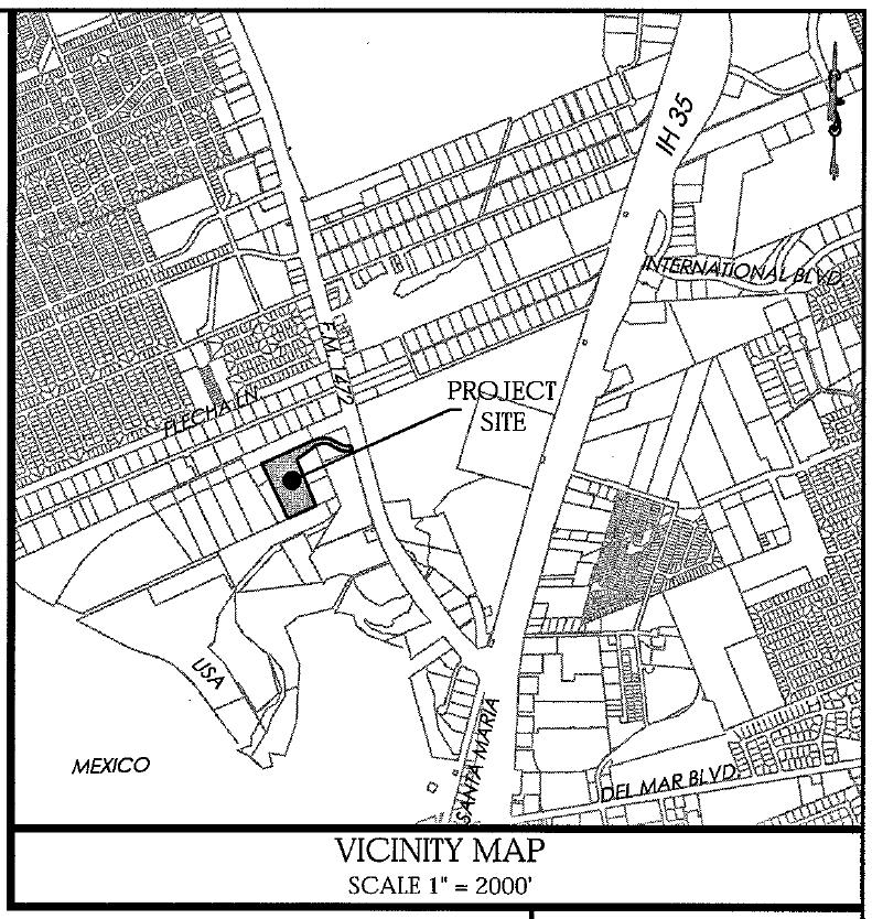
76 AGENDA ITEM: XI-D DATE: 04/06/17 APPLICANT: QMM Investments LLC ENGINEER: Daniel Gomez Engeering REQUEST: Final consideration of the Plat of North America Industrial Park Phase I. The intent is industrial. SITE: This 8.92 acre tract is located south of Flecha Lane. and west of F.M The zoning for this 5 lot development is AG & M-1. This tract is located in District VII- Cm. George Altgelt. PREVIOUS COMMISSION ACTION: This item was granted preliminary plat approval by the Planning & Zoning Commission on 12/15/2016. PROPOSED ACTION: APPROVAL
77
78
CITY OF LAREDO PLANNING AND ZONING COMMISSION
 CITY OF LAREDO PLANNING AND ZONING COMMISSION MINUTES OF THE PLANNING AND ZONING MEETING OF FEBRUARY 15, 2017 The City of Laredo Planning and Zoning Commission convened in special session open to the public
7. CONSIDERATION OF THE FOLLOWING PRELIMINARY PLATS AND PRELIMINARY REPLATS:
 A. Review and reconsideration of the Eleden Subdivision Master Plan. The intent is residential and commercial. The purpose of this revision is to create two phases out of one phase and to remove the extension
Synergy Park Addition (Companion to item 3)
") Synergy Park Addition (Companion to item 3) Attachments: 1. Locator 2. Replat staff report 3. Replat W P G r es rg eo e s Bu hh wy Lot 6A 4.02-acres Lot 4C 13.02-acres Fran k Lots 4C and 6A, Block A Synergy
Synergy Park Addition (Companion to item 3) Attachments: 1. Locator 2. Replat staff report 3. Replat W P G r es rg eo e s Bu hh wy Lot 6A 4.02-acres Lot 4C 13.02-acres Fran k Lots 4C and 6A, Block A Synergy
Honorable Mayor Bill Agan and members of the Richland Hills City Council. Final Plat Richland Hills, Lots 1 & 2, Block 1 Brumlow Addition
 2B - 1 Memorandum To: From: Date: Subject: Honorable Mayor Bill Agan and members of the Richland Hills City Council Jason Moore, Assistant City Manager January 17, 2017 Final Plat Richland Hills, Lots
Preliminary Plat/Final Plat Application
 Melissa Municipal Center 3411 Barker Avenue Melissa, Texas 75454 Phone: (972) 838-2036 Applicant: Date: Address: Phone: Contact: Fax: E-mail: Propose Addition Name: Acres: Existing Zoning: Propose Zoning:
AMENDING PLAT REQUIREMENTS Revised
 City of University Park AMENDING PLAT REQUIREMENTS Revised 10-2016 1. The amending plat is prepared with the appropriate certificates printed on the document and three (3) 24 x 36 paper copies are submitted
LOCATION MAP SHEET 1 OF 10
 OWNER: ADDRESS: LOCATION MAP CENTURY LAND HOLDINGS II, LLC 6500 RIVER PLACE BLVD. BUILDING 2, SUITE 200 AUSTIN, TX 78730 OWNER: CITY OF LEANDER ADDRESS: P.O. BOX 319 LEANDER, TX 78646 ACREAGE: LOTS ACREAGE:
SUBDIVISION APPLICATION
 SUBDIVISION APPLICATION Preliminary Plat Minor Plat Final Plat Amended Plat Applicant Name: Owner (if different from applicant) Name: Company: Company: Address: Address: City, State, Zip City, State, Zip
REPLAT REQUIREMENTS Revised
 City of University Park REPLAT REQUIREMENTS Revised 02-2016 1. The replat is prepared with the appropriate certificates printed on the document and three (3) 24 x 36 paper copies are submitted with a completed
RULES, REGULATIONS AND REQUIREMENTS RELATING TO THE APPROVAL AND ACCEPTANCE OF IMPROVEMENTS IN SUBDIVISIONS OR RE-SUBDIVISIONS
 GALVESTON COUNTY RULES, REGULATIONS AND REQUIREMENTS RELATING TO THE APPROVAL AND ACCEPTANCE OF IMPROVEMENTS IN SUBDIVISIONS OR RE-SUBDIVISIONS GALVESTON COUNTY ENGINEERING DEPARTMENT MARCH 3, 1997 Amendment
Township of Little Egg Harbor Planning Board 665 Radio Road Little Egg Harbor, New Jersey Phone: ext. 221 Fax:
 BLOCK(S) LOT(S) Township of Little Egg Harbor Planning Board 665 Radio Road Little Egg Harbor, New Jersey 08087 Phone: 609-296-7241 ext. 221 Fax: 609-294-3040 Development Application Amended Development
MINOR PLAT. The following documents are provided as required by the City of Conroe for use in the above titled platting submittals:
 Public Works - Engineering Division CITY OF CONROE MINOR PLAT The following documents are provided as required by the City of Conroe for use in the above titled platting submittals: Submittal Questionnaire
Memorandum September 13, 2018
 Memorandum September 13, 2018 TO: FROM: Planning and Zoning Commission Julie Couch, Town Manager Israel Roberts, AICP Planning Manager SUBJECT: FINAL PLAT FOR THE EBERSOHL ADDITION BACKGROUND: This is
AMENDING PLAT REQUIREMENTS Revised
 City of University Park AMENDING PLAT REQUIREMENTS Revised 9-3-2014 1. The amending plat is prepared with the appropriate certificates printed on the document and three (3) 24 x 36 paper copies are submitted
QUITCLAIM DEED CR 202 THE STATE OF TEXAS KNOW ALL MEN BY THESE PRESENTS: COUNTY OF WILLIAMSON
 QUITCLAIM DEED CR 202 THE STATE OF TEXAS KNOW ALL MEN BY THESE PRESENTS: COUNTY OF WILLIAMSON That WILLIAMSON COUNTY, TEXAS, hereinafter referred to as Grantor, whether one or more, for and in consideration
VACATING PLATS. The following documents are provided as required by the City of Conroe for use in the above titled platting submittals:
 Public Works - Engineering Division CITY OF CONROE VACATING PLATS The following documents are provided as required by the for use in the above titled platting submittals: Submittal Questionnaire (1-page).
Final Plat Mapping Requirements
 CURRENT PLANNING DIVISION 410 E. 5 th Street Loveland, CO 80537 970-962-2523 eplan-planning@cityofloveland.org cityofloveland.org/dc Final Plat Mapping Requirements All Final plats shall comply with the
ABBREVIATION LEGEND SITE INFORMATION:
 SITE INFORMATION: Current Zone: R-3 PUD, governed by Fox Hollow 2nd MDA Basis of Elevations: Northeast Corner of Section 13, T6S, R1W, S.L.B. & M Elevation: 4599.26 (Benchmark) ABBREVIATION LEGEND Owners:
Oakland County Michigan Register of Deeds Plat Engineering, GIS, & Remonumentation Dept. Ph: (248) Fax (248)
 Fax (248)") Oakland County Michigan Register of Deeds Plat Engineering, GIS, & Remonumentation Dept. Ph: (248)-858-1447 Fax (248)-858-7466 Requirements Needed for Final Plat Approval No. General Requirements. 1 Routing
Oakland County Michigan Register of Deeds Plat Engineering, GIS, & Remonumentation Dept. Ph: (248)-858-1447 Fax (248)-858-7466 Requirements Needed for Final Plat Approval No. General Requirements. 1 Routing
Planning. the propertyy. Texas Local. Government. Code. size of 2,0000 RSF-2-PUD. Road within the Wharf at a. Citizen. 0 Letter of. 1.
 Planning & Zoning Commissionn Replat Phase I of the Wharf at Clear Lake, Dock 18, Slips 1 and 2 Planning & Development Department February 15, 20166 Request Replat approximately 0.0209 acres of a previouslyy
MINOR SUBDIVISION PLAT CHECKLIST
 MINOR SUBDIVISION PLAT CHECKLIST Project Name: Tax ID #: Project Number: Date: _ Reviewed By: Telephone: NOTES: All lots on septic systems must comply with the Fulton County Health Department requirements
CITY OF DECATUR, TEXAS
 Final Plat or Amending Plat / Replat Checklist A submittal of a complete application will facilitate a timely review. Failure of the applicant to provide required information or obtain a waiver from the
APPLICATION FOR FINAL PLAT APPROVAL
 APPLICATION FOR FINAL PLAT APPROVAL Section 1. General. The undersigned Applicant (Applicant is synonymous with owner) makes this Application for Final Plat Approval in accordance with Chapter 21, Port
Subdivision Plat Signature Block Templates
 Subdivision Plat Signature Block Templates Please refer to the Subdivision Plat Checklist to determine which signature blocks are required for the plat you are preparing. All text must be at least 10 pt
FINAL PLAT. Community Development Department 8101 Ralston Road Arvada, Colorado 80002
 FINAL PLAT Community Development Department 8101 Ralston Road Arvada, Colorado 80002 September 2015 FINAL SUBDIVISION PLAT Final Subdivision Plat Review Applications for a Final Plat shall be submitted
Sketch & Legal Description of Mitigation Bank and Ingress/Egress Access Easements
 Appendix H: Sketch & Legal Description of Mitigation Bank and Ingress/Egress Access Easements Tippen Bay Wetland Mitigation Bank DeSoto County, Florida Prepared by: September, 2017 Original file
BILL NO (Emergency Measure) ORDINANCE NO. 5072
 ORDINANCE NO. 5072") BILL NO. 5210 (Emergency Measure) ORDINANCE NO. 5072 AN ORDINANCE AUTHORIZING THE MAYOR TO EXECUTE WITH MICHELSON-HADLEY HEIGHTS DEVELOPMENT, LLC, A CONTRACT AND QUIT CLAIM DEED CONVEYING CERTAIN PROPERTIES
BILL NO. 5210 (Emergency Measure) ORDINANCE NO. 5072 AN ORDINANCE AUTHORIZING THE MAYOR TO EXECUTE WITH MICHELSON-HADLEY HEIGHTS DEVELOPMENT, LLC, A CONTRACT AND QUIT CLAIM DEED CONVEYING CERTAIN PROPERTIES
Subdivision Plat Signature Block Templates
 Subdivision Plat Signature Block Templates Please refer to the Subdivision Plat Checklist to determine which signature blocks are required for the plat you are preparing. All text must be at least 10 pt
MINOR SUBDIVISION PLAT
 MINOR SUBDIVISION PLAT Community Development Department 8101 Ralston Road Arvada, Colorado 80002 MINOR SUBDIVISION PLAT Subdivisions consisting of five (5) or fewer lots are eligible for the minor subdivision
OWNERS ACKNOWLEDGMENT
 OWNERS ACKNOWLEDGMENT STATE OF TEXAS COUNTY OF GALVESTON/HARRIS I (or we), (name of owner or owners) acting by and through (name and title of officer) being officers of (name of company or corporation),
MINOR SUBDIVISION PLAT
 MINOR SUBDIVISION PLAT Community Development Department 8101 Ralston Road Arvada, Colorado 80002 September 2015 MINOR SUBDIVISION PLAT Subdivisions consisting of five (5) or fewer lots are eligible for
The Filing Fee for a Minor Plat is $ PLUS $20.00 per lot created
 DEPARTMENT OF COMMUNITY DEVELOPMENT MINOR PLAT PROCEDURE The Filing Fee for a Minor Plat is $250.00 PLUS $20.00 per lot created Description: The purpose of a Minor Plat is to allow property to be platted
FINAL PLAT CHECKLIST
 FINAL PLAT CHECKLIST Project Name: Tax ID #: Project Number: Date: _ Reviewed By: Telephone: Please address all items marked with an "X" Please return redline comments with corrected plan, original mylar,
Planning. Preliminary. .70 acres into. tract of land. an unplatted. Edgar Barlow. 1. Proposed 2. Aerial Map. Subdivision
 Preliminary / Final Plat Glenmont, Section Two Planning & Zoning Commissionn Planning & Development Department May 19, 20144 Request Applicant Owner Zoning Location Attachments Subdivide approximately.70
APPENDIX C: PLAT SPECIFICATIONS AND CERTIFICATES
 APPENDIX C: PLAT SPECIFICATIONS AND CERTIFICATES A. Drawing. All plats for recording must be submitted on photographically reproducible and dimensionally stable polyester sheets such as Mylar, Cronar or
E. 140TH AVE. VICINITY MAP SCALE: 1"=600' LAND USE TABLE NET AREA 599,946 SQFT AC. GROSS AREA 741,420 SQFT AC.
 SHEET OF PURPOSE STATEMENT: THIS PLAT IS INTENDED TO SUBDIVIDE. ACRES INTO SINGLE FAMILY ATTACHED LOTS, TRACTS, DEDICATE AND GRANT EASEMENTS. LEGAL DESCRIPTION: THE UNDERSIGNED BEING THE OWNER(S) OF A
Community Development Department Council Chambers, 7:30 PM, July 20, 2017
 STAFF REPORT 2017-25P: Subdivision Community Development Department Council Chambers, 7:30 PM, July 20, 2017 To: From: Re: Paul Luke, Chairman, Skokie Plan Commission Mike Voitik, Planning Technician 2017-25P:
Boundary Line Adjustment Application
 Boundary Line Adjustment Application A COMPLETE APPLICATION is required at the time of submittal. REQUIRED SUBMITTALS: 1. Application form 2. Application Fee - $500.00. 3. Current title report 4. Three
FINAL PLAT APPLICATION
 FINAL PLAT APPLICATION (Page 1 of 3) LEGAL OWNER(s): NAME: STREET ADDRESS OWNER(s): CITY, STATE, ZIP CODE: PHONE NUMBER: BILLING ADDRESS: NAME OF ENGINEER/SURVEYOR: Engineer/Surveyor Address, Phone: PROPERTY
PARCEL MAP CHECK ENG
 Engineering Division 201 North Broadway, Escondido, CA 92025 (760) 839-4651, FAX (760) 839-4597 PARCEL MAP CHECK ENG To: Date: Project: Site Address Check No. Attn: Via: The attached plans have been reviewed
I. Requirements for All Applications. C D W
 108-16.1. Application checklists. Checklist for Required Submissions to the Planning Board or Zoning Board of Adjustment of Monroe Township All required submissions are to be made to the Administrative
SUBDIVISION AND LAND DEVELOPMENT. 185 Attachment 20
 185 Attachment 20 APPENDIX S Plat No. Date of Submission Twp. Fee $ Dauphin Co. Fee $ TOWNSHIP OF DERRY SUBDIVISION OR LAND DEVELOPMENT PLAN SUBMISSION APPLICATION This block for Twp. use only 1. Title
PRELIMINARY PLATS. The following documents are provided as required by the City of Conroe for use in the above titled platting submittals:
 Public Works Engineering Division CITY OF CONROE PRELIMINARY PLATS The following documents are provided as required by the City of Conroe for use in the above titled platting submittals: Submittal Questionnaire
The City Council of the City of Sulphur, Louisiana, met in special session at its
 July 12, 2018 The City Council of the City of Sulphur, Louisiana, met in special session at its regular meeting place in the Council Chambers, Sulphur, Louisiana, on July 12, 2018 at 5:00 p.m., after full
Subdivision - Minor Plat Submittal
 Subdivision - Minor Plat Submittal This Checklist is intended to provide the information and data that is necessary to assess the merits of the project proposal. Please note that this Checklist is intended
DAUPHIN CREEK ESTATES SUBDIVISION
 # 12 SUB-000076-2017 DAUPHIN CREEK ESTATES SUBDIVISION Engineering Comments: FINAL PLAT COMMENTS (should be addressed prior to submitting the FINAL PLAT for review and/or signature by the City Engineer):
COUNCIL AGENDA MEMO ITEM NO. III - #1
 COUNCIL AGENDA MEMO ITEM NO. III - #1 FROM: Anton Jelinek, Director of Utilities MEETING: October 24, 2017 SUBJECT: PRESENTER: Permanent Utility and Right-of-Way Easement Anton Jelinek Discussion: At the
LANDSCAPE AND MAINTENANCE EASEMENT. THIS LANDSCAPE AND MAINTENANCE EASEMENT, (hereinafter Easement )
") Prepared by and return to: Parcel ID # LANDSCAPE AND MAINTENANCE EASEMENT THIS LANDSCAPE AND MAINTENANCE EASEMENT, (hereinafter Easement ) is made and entered into this day of, 2009, by and between THIRD
Prepared by and return to: Parcel ID # LANDSCAPE AND MAINTENANCE EASEMENT THIS LANDSCAPE AND MAINTENANCE EASEMENT, (hereinafter Easement ) is made and entered into this day of, 2009, by and between THIRD
FINAL MAP PLAN CHECK
 Engineering Division 201 North Broadway, Escondido, CA 92025 (760) 839-4651, FAX (760) 839-4597 FINAL MAP PLAN CHECK To: Date: Project: Address: Check No: Attn: VIA: The attached FINAL MAP has been reviewed
SUBDIVISION APPLICATION
 STAFF USE ONLY Date Submitted: Received by: Fee paid: Project # REQUIRED SUBMITTALS Application Fee: $600.00 (up to 5 lots) + $50.00 (per lot above 5) Publication Fee: $300.00 Mailing Fee: $6.00 per hearing
City of Lakewood Plat Specifications
 City of Lakewood Plat Specifications Revised 12/15/2015 Plat Checklist.1 Notes, Certifications and Acknowledgements..5 Electronic Submittal Information... 20 Sheet Layout.21 A Professional Land Surveyor,
SUBMITTAL REQUIREMENTS: The number indicates the number of copies for submittal (if applicable).
.") Office Use Only Preliminary Long Plat Long Subdivision Applicant Checklist PLANNING, COMMUNITY, & ECONOMIC DEVELOPMENT DEPARTMENT FINAL LONG PLAT LONG SUBDIVISION CHECKLIST Mailing Address: P.O. Box 547,
Office Use Only Preliminary Long Plat Long Subdivision Applicant Checklist PLANNING, COMMUNITY, & ECONOMIC DEVELOPMENT DEPARTMENT FINAL LONG PLAT LONG SUBDIVISION CHECKLIST Mailing Address: P.O. Box 547,
Ballard City Final Plat Check List
 Ballard City Final Plat Check List TO BE COMPLETED BY BOTH THE DEVELOPER AND THE CITY Design: Check: Check each of the following items for compliance with adopted City Standards, Titles, General Plans
SUBDIVISION APPLICATION
 SUBDIVISION APPLICATION City of Horn Lake Planning Department 3101 Goodman Road, W Horn Lake, MS 38637 662-342-3559 Fax: 662-342-3485 Applications due the 1st working day of the month. Submit application
A Preliminary Plat is required in addition to a Final Plat or Replat if any of the following apply:
 DO YOU NEED A PLAT? City of Grapevine, Texas PLATTING INFORMATION Updated July 22, 2014 Public Works Department Engineering Division 200 South Main Street Grapevine, Texas 76051 Tele: 817.410.3136 Fax:
NOT TO BE SUBMITTED WITH SKETCH DESIGN APPROVAL Subdivision Checklist: Major Subdivision Final Plat
 Must be received with review fee (equal to $200.00, plus $25.00 per lot) no later than 15 days prior to Planning Board meeting, which is normally the first Monday of the month (certain holidays may modify
PRELMINARY PLAT CHECKLIST
 PRELMINARY PLAT CHECKLIST A. All preliminary plat submitted for approval shall be prepared by a Registered Professional Land Surveyor. B. Preliminary plats must be drawn to a scale of XXX with such accuracy
ARTICLE 900 PLAT AND PLAN REQUIREMENTS
 ARTICLE 900 PLAT AND PLAN REQUIREMENTS SEC. 900.1 ITEMS TO BE SHOWN ON PLAT OR PLAN General (1) Property lines of all property owners adjacent to the exterior boundaries of the project shall be located
MAJOR RESIDENTIAL AND NONRESIDENTIAL SUBDIVISIONS
 Lawrence-Douglas County MAJOR RESIDENTIAL AND NONRESIDENTIAL SUBDIVISIONS Preliminary Plats The applicant shall schedule a Pre-Application meeting with Planning Staff at least seven (7) working days prior
PLANNING COMMISSION SUBDIVISION PLAT APPLICATION
 PLANNING COMMISSION SUBDIVISION PLAT APPLICATION Economic Development Department 3468 North Fulton Avenue Hapeville, Georgia 30354 Phone - 404.669.8269 Fax 404.669.3302 Rev. 09/23/16 1 The following information
AGENDA ITEM G-2 Public Works
 AGENDA ITEM G-2 Public Works STAFF REPORT City Council Meeting Date: 2/23/2016 Staff Report Number: 16-035-CC Consent Calendar: Adopt a resolution accepting Easements and approving the abandonment of two
SUBMITTAL REQUIREMENTS: The number indicates the number of copies for submittal (if applicable).
.") Office Use Only Preliminary Long Plat Long Subdivision Applicant Checklist PLANNING, COMMUNITY, & ECONOMIC DEVELOPMENT DEPARTMENT PRELIMINARY LONG PLAT LONG SUBDIVISION CHECKLIST Mailing Address: P.O.
Office Use Only Preliminary Long Plat Long Subdivision Applicant Checklist PLANNING, COMMUNITY, & ECONOMIC DEVELOPMENT DEPARTMENT PRELIMINARY LONG PLAT LONG SUBDIVISION CHECKLIST Mailing Address: P.O.
MINOR PLAT FILING APPLICATION
 FILING APPLICATION Date of PC Meeting: Date of BCC Meeting: Fee Paid: 1. APPLICANT: DAYTIME PHONE: MAILING ADDRESS: LANDOWNER: DAYTIME PHONE: MAILING ADDRESS: AUTHORIZED AGENT: MAILING ADDRESS: RELATIONSHIP
CITY OF SARALAND FINAL SUBDIVISION PLAT REVIEW
 CITY OF SARALAND FINAL SUBDIVISION PLAT REVIEW Application Number: Date Plat Submitted: Name of Subdivision: Name of Owner: Owner Address: (Street or P.O. Box) Telephone #: (City) (State) (Zip) E-mail:
WASTEWATER BACKFLOW RELEASE PROCEDURES
 WASTEWATER BACKFLOW RELEASE PROCEDURES PROCEDURE FOR OBTAINING A WASTEWATER RELEASE FOR PRIVATE DEVELOPMENT PROJECTS: PLEASE NOTE THAT THE WASTEWATER BACKFLOW RELEASE DOCUMENT MUST FOLLOW THE CITY S PROCEDURES.
PROPERTY DESCRIPTION: Property is located in: City Limits County(Outside City Limits) Site Address/Location:
 Site Address/Location:") Application for Lot-Tract Split/Combo or Property Line Adjustment CITY OF CENTERTON PLANNING DEPARTMENT 290 N. MAIN ST., P.O. BOX 208 CENTERTON, AR 72719 PHONE (479)795-2750 FAX (479)795-2545 Planning@centertonar.us
Application for Lot-Tract Split/Combo or Property Line Adjustment CITY OF CENTERTON PLANNING DEPARTMENT 290 N. MAIN ST., P.O. BOX 208 CENTERTON, AR 72719 PHONE (479)795-2750 FAX (479)795-2545 Planning@centertonar.us
DALLAS WATER UTILITIES WATER/WASTEWATER COVENANT
 DALLAS WATER UTILITIES WATER/WASTEWATER COVENANT Procedure for obtaining a water and wastewater covenant, water covenant, or wastewater covenant; Required for initial submittal: 1. One letter from the
City of Shenandoah Development Package
 Upon completion return application to Development@shenandoahtx.us City of Shenandoah Development Package Documentation includes the following: Fee Schedule Platting Development Check List & Outline Development
Department of Development Services Engineering; Survey Plat Review Group SPRG
 Department of Development Services Engineering; Survey Plat Review Group SPRG CITY OF DALLAS LEGAL DESCRIPTION PREPARATION GUIDELINE AND CHECKLIST The following guideline and checklist are provided to
ORDINANCE NO AN ORDINANCE To Be Entitled:
 3808 AN ORDINANCE To Be Entitled: AN ORDINANCE OF THE CITY COUNCIL OF THE CITY OF FORT MYERS, FLORIDA, REZONING FROM COMMERCIAL GENERAL TO PLANNED UNIT DEVELOPMENT AND APPROVING THE DEVELOPMENT PLAN FOR
PLANNING AND DEVELOPMENT DEPARTMENT PRELIMINARY PLAT APPLICATION
 PLANNING AND DEVELOPMENT DEPARTMENT PRELIMINARY PLAT APPLICATION IT IS INCUMBENT UPON THE APPLICANT TO SUBMIT COMPLETE AND CORRECT INFORMATION. ANY MISLEADING, DECEPTIVE, INCOMPLETE OR INCORRECT INFORMATION
ettjt. RE/Jto sn?m"" DATE & H01JA7
 ., 525459 No. _'l'fn::ii!:lii=nr--- AT THE AeaUEst 6F: ettjt. RE/Jto sn?m"" DATE & H01JA7 THIS DEVELOPMENT AGREEMENT for the Indian Hills 6th Addition subdivision between Thompson Development, L.L. C.,
WATERFORD LANDING COMMUNITY DEVELOPMENT DISTRICT REGULAR MEETING AGENDA
 WATERFORD LANDING COMMUNITY DEVELOPMENT DISTRICT REGULAR MEETING AGENDA January 31, 2019 Waterford Landing Community Development District OFFICE OF THE DISTRICT MANAGER 2300 Glades Road, Suite 410W Boca
APPLICATION PROCEDURE
 ANTRIM PLANNING BOARD P. O. Box 517 Antrim, New Hampshire 03440 Phone: 603-588-6785 FAX: 603-588-2969 APPLICATION FORM AND CHECKLIST FOR MINOR OR MAJOR SITE PLAN REVIEW File Date Received By APPLICATION
Submittal Requirements: Subdivision Plat (Final)
") s Planning and Zoning Submittal Requirements: Subdivision Plat (Final) 1. Application form, APO fees, and filing fee. Transportation Development Review Fee please contact Engineering at (970) 221-6605
s Planning and Zoning Submittal Requirements: Subdivision Plat (Final) 1. Application form, APO fees, and filing fee. Transportation Development Review Fee please contact Engineering at (970) 221-6605
PLANNED DEVELOPMENT DISTRICT A ACRE TRACT KNOWN AS GEAN ESTATES CITY OF KELLER, TARRANT COUNTY TEXAS
 PLANNED DEVELOPMENT DISTRICT A 105.026 ACRE TRACT KNOWN AS GEAN ESTATES CITY OF KELLER, TARRANT COUNTY TEXAS A. Exhibit A Development Regulations B. Exhibit B Legal Description C. Exhibit C Conceptual
# 6 Case #SUB LEGACY SUBDIVISION. Engineering Comments: Must comply with the Mobile County Flood Damage Prevention Ordinance.
 LEGACY SUBDIVISION Engineering Comments: Must comply with the Mobile County Flood Damage Prevention Ordinance. The plat illustrates the proposed 46 lot, 26.7 + acres subdivision which is located on the
VICINITY MAP/AERIAL MAP SITE
 VICINITY MAP/AERIAL MAP SITE N ZONING MAP PA 9 PA 5 SITE Solterra West ODP PA 7 N , DATE, 2013, TIME, COUNTY OF JEFFERSON, STATE OF COLORADO, $ DEDICATION CERTIFICATE THE UNDERSIGNED, BEING THE OWNER(S)
GREENWAY EASEMENT AGREEMENT
 GREENWAY EASEMENT AGREEMENT This greenway access easement is entered into by and between the Laramie County School District Number One ( Grantor ), a corporate body organized under the laws of the State
Community Development Department Council Chambers, 7:30 PM, December 1, 2016
 STAFF REPORT 2016-35P: Subdivision Community Development Department Council Chambers, 7:30 PM, December 1, 2016 To: From: Re: Paul Luke, Chairman, Skokie Plan Commission Mike Voitik, Planning Technician
PLANNING AND ZONING COMMISSION
 PLANNING AND ZONING COMMISSION NOTICE OF PUBLIC MEETING City of Laredo City Hall City Council Chambers 1110 Houston Street Laredo, Texas September 20, 2018 6:00 p.m. MEETING AGENDA 1. CALL TO ORDER - :.
CHAPTER 26 PLANNING AND ZONING ARTICLE VII. MOBILE HOMES AND RECREATIONAL VEHICLE (RV) PARKS. Recreational Vehicle (RV) Park Development Standards
 PARKS. Recreational Vehicle (RV) Park Development Standards") CHAPTER 26 PLANNING AND ZONING ARTICLE VII. MOBILE HOMES AND RECREATIONAL VEHICLE (RV) PARKS. Section 26-VII-1. Section 26-VII-2. Section 26-VII-3. Section 26-VII-4. Section 26-VII-5. Purpose Permitted
CHAPTER 26 PLANNING AND ZONING ARTICLE VII. MOBILE HOMES AND RECREATIONAL VEHICLE (RV) PARKS. Section 26-VII-1. Section 26-VII-2. Section 26-VII-3. Section 26-VII-4. Section 26-VII-5. Purpose Permitted
SUBDIVISION PLAT CHECKLIST. The following information shall be include on the plat:
 SUBDIVISION PLAT CHECKLIST Subdivision Name: Land Surveyor: Owner/Developer: Date Submitted: The following information shall be include on the plat: The plat shall be drawn at a scale of one inch equals
MEMORANDUM. Mayor and City Council. Warren Hutmacher, City Manager. Date: February 11, 2013
 MEMORANDUM To: From: Mayor and City Council Warren Hutmacher, City Manager Date: February 11, 2013 Subject: Approval of an Intergovernmental agreement by and between the City of Dunwoody and DeKalb County
PLANNING AND ZONING COMMISSION NOTICE OF PUBLIC MEETING
 PLANNING AND ZONING COMMISSION NOTICE OF PUBLIC MEETING City of Laredo City Hall City Council Chambers 1110 Houston Street Laredo, Texas October 18, 2018 6:00 p.m. MEETING AGENDA 1. CALL TO ORDER 2. ROLL
CLARK 3925 E. US 377 COMMERCIAL $699,000 COMMERCIAL PAD SITE IN FRONT OF NEW KROGER. Granbury, Texas
 PAD SITE IN FRONT OF NEW KROGER $699,000 1.858 Acres Monument sign on 377 377 road frontage Platted Zoned Utilities to the site PROPERTY INFORMATION Property Information: Adjacent to recently opened Kroger
to St. Louis County by deed recorded in Book 7954, Page 235 in the St. Louis County, Missouri
 Recommendation of Planning Commission BILL NO. 4032 ORDINANCE NO. 2015-3971 AN ORDINANCE ENACTING A CONDITIONAL USE PERMIT FOR AN ELECTRICAL SUBSTATION AT 11520 DORSETT ROAD Petition of Ameren Missouri)
SECTION 6 - APPROVAL OF PLATS. Whenever any subdivision of land is proposed, and before any permit for the
 SECTION 6 - APPROVAL OF PLATS 6-1 APPROVAL REQUIRED BEFORE SALE Whenever any subdivision of land is proposed, and before any permit for the erection of a structure shall be granted, the subdivider or his
APPENDIX B. SUBMISSION REQUIREMENTS
 Master Major Site Minor Site Landscape Section B.1 Table of /Plat Requirements Proposed or approved name of development, project, subdivision, and/or phase. Location, including township, county, and state.
ORDINANCE NO. Z REZONING NO
 ORDINANCE NO. Z- 3960 REZONING NO. 2018-00014 AN ORDINANCE RELATING TO ZONING: AMENDING CERTAIN ZONING REGULATIONS SHOWN ON SHEET NO. 15 OF THE ZONING DISTRICT MAP INCORPORATED BY REFERENCE BY OVERLAND
ARTICLE 900 PLAT AND PLAN REQUIREMENTS
 Final SEC. 900.01 ARTICLE 900 PLAT AND PLAN REQUIREMENTS General provisions. (a) Scale. The scale of all plats and plans shall be a minimum of 1 to 100 ft. (b) Size. The minimum page size for all plats
SUBDIVISION APPLICATION: RECOMBINATION PLAT or EXEMPT PLAT
 SUBDIVISION APPLICATION: RECOMBINATION PLAT or EXEMPT PLAT Pursuant to Article 7, Section 155.706 of the Unified Development Code, an owner of land within the jurisdiction of the Town (or a duly authorized
COUNTY OF ALBEMARLE APPLICATION FOR RURAL SUBDIVISION
 Page 1 APPLICATION FOR RURAL SUBDIVISION The term rural subdivision means a type of subdivision that is located in the rural areas which results in two or more lots for the purpose of transfer of ownership
FINAL SUBDIVISION AND LAND DEVELOPMENT PLAN CHECKLIST. Plan Name. Applicant's Name:
 TOWNSHIP OF UPPER ST. CLAIR FINAL SUBDIVISION AND LAND DEVELOPMENT PLAN CHECKLIST Date Filed Plan Name PLC Applicant's Name: Phone Filing Date for Final Application Final Plat 114.22. FINAL APPLICATION
NO DEED OF RESTRICTIONS CANYON SPRINGS RESORT, INC. TO THE PUBLIC. COUNTY OF COMAL KNOW ALL MEN BY THESE PRESENTS:
 UNITS I, II, AND III NO. 62100 DEED OF RESTRICTIONS CANYON SPRINGS RESORT, INC. TO THE PUBLIC. THE STATE OF TEXAS COUNTY OF COMAL KNOW ALL MEN BY THESE PRESENTS: That CANYON SPRINGS RESORT, INC., a Corporation
STANDARD LANGUAGE FORMAT GUIDE PLANNING SERVICES DIVISION
 A. OWNERSHIP CERTIFICATE The purpose of the ownership certificate is to identify the owner and provide the Volume and Page of Deed Records, verifying the ownership. When the property owner is a corporation,
Residential Minor Subdivision Review Checklist
 Residential Minor Subdivision Review Checklist Plan Submittal Requirements: 2 full sets of stamped plans Electric submittal - all plans contained in a single PDF 3 full sets if commercial kitchen or dining
ALBA BEACH SUBDIVISION, RESUBDIVISION OF LOT 17
 ALBA BEACH SUBDIVISION, RESUBDIVISION OF LOT 17 Engineering Comments: FINAL PLAT COMMENTS (should be addressed prior to submitting the FINAL PLAT for acceptance and signature by the City Engineer): A.
City of Yelm. Community Development Department BOUNDARY LINE ADJUSTMENT OR LARGE LOT SUBDIVISION
 City of Yelm Community Development Department BOUNDARY LINE ADJUSTMENT OR LARGE LOT SUBDIVISION Fee Date Received By File No. FEES: Boundary Line Adjustment $100.00 LARGE LOT SUBDIVISION $250.00, + $10.00/lot
Plan and Zoning Commission Review Process
 . Village of Northfield Plan and Zoning Commission Review Process.......... Department of Community Development and Building Village of Northfield Department of Community Development and Building 361 Happ