PLANNED DEVELOPMENT DISTRICT A ACRE TRACT KNOWN AS GEAN ESTATES CITY OF KELLER, TARRANT COUNTY TEXAS
|
|
|
- Nicholas Melton
- 5 years ago
- Views:
Transcription
1 PLANNED DEVELOPMENT DISTRICT A ACRE TRACT KNOWN AS GEAN ESTATES CITY OF KELLER, TARRANT COUNTY TEXAS A. Exhibit A Development Regulations B. Exhibit B Legal Description C. Exhibit C Conceptual Land Plan D. Exhibit D Screening & Fencing Plan E. Exhibit E Amenity Plan F. Exhibit F Zoning District Map G. Exhibit G Planned Development Concept Plan
2 EXHIBIT A DEVELOPMENT REGULATIONS I. General The purpose of this Planned Development Zoning District is to establish minimum requirements of the residential PD established herein. The intent is to provide quality subdivision and thoroughfare development with residential uses in an orderly fashion. Following approval of this ordinance, the developer shall prepare, in a phased manner where applicable, construction plans, preliminary plat and a final plat for each area to be developed and conforming to the criteria established herein. This PD Ordinance addresses of the acre Gean Estates tract. The balance that is not subjected to this rezoning does not require rezoning for it s intended purpose Nature Preserve, therefore is not included. II. Regulations, Permitted Uses, Maximum Units and Acreage Requirements Exhibit C contains the Gean Estates Conceptual Land Plan and conceptually describes how the site will be developed. A. Residential Districts: 1. PD-SF-15: All Descriptions, Permitted Uses, Regulations, and Requirements prescribed by Article Eight, Section 8.03 Zoning Districts, SF-15, as Amended , beginning on page 8-35, and those regulations included by reference to, of the Unified Development Code of the City of Keller shall be followed for the PD area containing SF-15 lots as generally defined on the Exhibit C - Conceptual Land Plan. 2. PD-SF-20: All Descriptions, Permitted Uses, Regulations, and Requirements prescribed by Article Eight, Section 8.03 Zoning Districts, SF-20, as Amended , beginning on page 8-31, and those regulations included by reference to, of the Unified Development Code of the City of Keller shall be followed for the PD area containing SF-20 lots as generally defined on the Conceptual Land Plan. A unit shall be defined as a separately inhabitable sellable or leasable space intended to be occupied by a single individual or family. The following zoning district is hereby created to apply to the property within the Planned Development District. The property within the Planned Development District may be developed only in accordance with the maximum unit and acreage limits set forth as follows:
3 Zoning District Lot Description # of Units* SF-15 Single Family Residential: minimum 15,000 sf 83 (max) SF-20 Single Family Residential: minimum 20,000 sf 29 (min) *the average lot size for the entire development, not evaluated on a per phase basis, must average a minimum of 20,000 square feet. The maximum acreage of the Residential Districts, along with all lots, Rights-of-Way, Open Spaces, Common Spaces, Amenity Center(s) or any other use other than Nature Preserve described below shall not exceed 89.0 acres of the PD District. See Exhibit F for location of the Residential Districts in this PD. B. Nature Preserve (PD-SF-LD) The Nature Preserve is the key component of this Planned Development that seeks to maintain, in perpetuity, the bucolic scenery and lifestyle that the current and future residents of Keller have come to appreciate and expect. It does this while maintaining, in its natural state, the beautifully wooded eastern portion of the PD area and the balance of the contiguous Gean Property that is not within the PD area. This Nature Preserve will be conveyed by Final Plat to the City of Keller, as Final Platting occurs. The developer will not alter the Nature Preserve in any way, other than those necessary to build utilities or transition grades through or adjacent to the Nature Preserve. The City will cooperate to allow the construction of roads, utilities, and residential development through and adjacent to the Nature Preserve including, but not limited to, the granting of the right to grade on to the Nature Preserve for the purposes of transiting grade from residential development site to natural ground, in the interest of minimizing the need for retaining walls. In addition, any improvements made to the Nature Preserve including, but not limited to parking, nature trail construction, trail head installation, etc., shall be made by City after dedication. The minimum acreage of the Nature Preserve District shall not be less than 18 acres of the PD District (35 acres when combined with the portion of the Nature Preserve that is not within the PD Area. See Exhibit F for location of the Nature Preserve in this PD.
4 III. Supplementary Development and Design Standards The developer desires to construct a development and homes that have features beyond those required by minimum City standards in order to create the quality development desired. These Architectural enhancements and Site Features (as they pertain to the lots), as enumerated below, will be required by the Covenants, Conditions and Restrictions (CC & Rs) to be created, filed for record and made a permanent Deed Restriction on the lots. These Deed Restrictions will be enforced by a Home Owners Association (HOA) that the developer will create and turn over to an elected board of residents. This HOA will collect dues and through these dues, and in addition to enforcement of Deed Restrictions, the HOA shall be primarily responsible for the maintenance of Private Open Spaces, Decorative Lighting, Screening Walls and Amenities, including Amenity Center. A. Architectural Gifts to the Street building enhancements that improve feel and experience of the street. All homes shall utilize at least six (6) of the following design features to provide visual relief along the front of a residence: Architectural garage doors Architectural pillars or posts Bay window Masonry chimney on exterior wall (front of house) Cast stone accents Covered front porch (minimum 70 square feet) Cupolas or turrets Dormer with window Gables Metal roof accents Multiple types of masonry Exposed aggregate driveway 10/12 roof pitch or greater Masonry arches Divided light windows Wood shutters Decorative gable feature greater than 3 square feet in size.


 Street Signs: Street signs shall be mounted on decorative poles of similar quality to")
5 B. Site Features 1. Mailboxes Mailboxes within the PD Area shall be located within the parkway near the side property line and shall be groups in pairs where feasible. All the mailboxes within the PD shall be the same. The mailboxes shall be of similar quality to the following examples: 2. Signage and Lighting a) Traffic Signs: Traffic signs shall be mounted on decorative poles of similar quality to the following: b) Street Signs: Street signs shall be mounted on decorative poles of similar quality to the following: c) Street Lights: Street Lights shall be mounted on decorative poles with decorative fixtures of similar quality to the following:
6 3. Fencing All private fencing, not indicated on Exhibit D shall be 8 Stained Wooden Fencing. 4. Hardscape, Landscape, & Amenity Improvements All development within the Gean Estates Planned Development District shall comply with the requirements of Section 9.03 Landscape Requirements of the City of Keller Unified Development Code and shall further be described and provided in accordance with: Exhibit D Screening and Fencing Plan Exhibit E Amenity Plan Note: Only City minimum required screening and landscaping shall be considered with respect to the final acceptance of a phase. IV. Applicability of All City Ordinances This Planned Development is subject to all development regulations, in the Unified Development Code, of the City of Keller, as of the date of the passage of this ordinance.
7 EXHIBIT B LEGAL DESCRIPTION BEING A ACRE TRACT OF LAND SITUATED IN THE D. BARCROFT SURVEY, ABSTRACT NO. 141, CITY OF KELLER, TARRANT COUNTY, TEXAS, AND BEING PART OF A TRACT OF LAND, CONVEYED TO JAMES GEAN AND MARGARET GEAN, BY DEED RECORDED IN VOLUME 3043, PAGE 141, DEED RECORDS, TARRANT COUNTY, TEXAS, PART OF A TRACT OF LAND CONVEYED TO JAMES GEAN AND MAGRARET GEAN, BY DEED RECORDED IN VOLUME 3044, PAGE 169, DEED RECORDS, TARRANT COUNTY, TEXAS, AND PART OF A TRACT OF LAND CONVEYED TO GEAN PROPERTIES, LTD., BY DEED RECORDED IN COUNTY CLERK S FILE NO. D , D , D , AND D , OFFICIAL PUBLIC RECORDS, TARRANT COUNTY, TEXAS. SAID ACRE TRACT, WITH BEARING BASIS BEING GRID NORTH, TEXAS STATE PLANE COORDINATES, NORTH CENTRAL ZONE, NAD83 (CORS96, EPOCH DATE 2002), DETERMINED BY GPS OBSERVATIONS BETWEEN JULIAN DAY 253, 2004 AND JULIAN DAY 259, 2004, CALCULATED FROM DENTON CORS ARP (PID-DF8986) AND ARLINGTON RRP2 CORS ARP (PID-DF5387) AND BEING MORE PARTICULARLY DESCRIBED BY METES AND BOUNDS AS FOLLOWS: BEGINNING AT 3/8 IRON ROD FOUND FOR THE NORTHWEST CORNER OF SAID GEAN TRACT (VOL.3043, PG.141), SAID POINT BEING ON THE EAST LINE OF A TRACT OF LAND CONVEYED TO ROBERT CANNON AND WIFE, ANNETTA CANNON, BY DEED RECORDED IN VOLUME 4685, PAGE 689, DEED RECORDS, TARRANT COUNTY, TEXAS, AND ON THE SOUTH RIGHT-OF-WAY LINE OF BANCROFT ROAD, A VARIABLE WIDTH RIGHT-OF-WAY; THENCE, NORTH 89 DEGREES 52 MINUTES 04 SECONDS EAST, ALONG THE NORTH LINE OF SAID GEAN TRACT (VOL. 3043, PG. 141), AND THE COMMON SOUTH RIGHT-OF-WAY LINE OF SAID BANCROFT ROAD, A DISTANCE OF FEET TO A POINT; THENCE, OVER AND ACROSS SAID GEAN TRACT, (VOL. 3043, PG. 141), (VOL. 3044, PG. 169), AND SAID GEAN PROPERTIES, LTD. TRACT, THE FOLLOWING COURSES AND DISTANCES: SOUTH 00 DEGREES 00 MINUTES 13 SECONDS EAST, A DISTANCE OF FEET TO A POINT FOR CORNER; NORTH 89 DEGREES 52 MINUTES 04 SECONDS EAST, A DISTANCE OF FEET TO A POINT FOR CORNER; SOUTH 00 DEGREES 20 MINUTES 17 SECONDS EAST, A DISTANCE OF FEET TO A POINT FOR CORNER ON THE SOUTH LINE OF SAID GEAN PROPERTIES, LTD. TRACT, AND THE COMMON NORTH LINE OF LOT 1,
8 BLOCK 1 OF THE FIRST UNITED METHODIST CHURCH ADDITION, AN ADDITION TO THE CITY OF KELLER, AS RECORDED IN CABINET A, SLIDE 1170, PLAT RECORDS, TARRANT COUNTY, TEXAS; THENCE, ALONG THE SOUTH LINE OF SAID GEAN PROPERTIES, LTD. TRACT, THE SOUTH LINE OF SAID GEAN TRACT, (VOL. 3044, PG. 169), AND SAID GEAN TRACT, (VOL. 3043, PG. 141), THE FOLLOWING COURSES AND DISTANCES: SOUTH 89 DEGREES 53 MINUTES 16 SECONDS WEST, ALONG THE SOUTH LINE OF SAID GEAN PROPERTIES, LTD. TRACT, AND THE COMMON NORTH LINE OF SAID LOT 1, BLOCK 1, A DISTANCE OF FEET TO A 1/2" CAPPED IRON ROD FOUND FOR THE NORTHWEST CORNER OF SAID LOT 1, BLOCK 1 OF SAID FIRST UNITED METHODIST CHURCH ADDITION, SAID POINT BEING ON THE EAST LINE OF A CALLED 30 ACRE TRACT OF LAND CONVEYED TO KELLER I.S.D., BY DEED RECORDED IN COUNTY CLERK S FILE NO. D , OFFICIAL PUBLIC RECORDS, TARRANT COUNTY, TEXAS; NORTH 00 DEGREES 11 MINUTES 19 SECONDS EAST, ALONG THE EAST LINE OF SAID KELLER I.S.D. TRACT, A DISTANCE OF FEET TO A 5/8" CAPPED IRON ROD FOUND FOR THE NORTHEAST CORNER OF SAID KELLER I.S.D. TRACT; SOUTH 89 DEGREES 59 MINUTES 47 SECONDS WEST, ALONG THE NORTH LINE OF SAID KELLER I.S.D. TRACT, A DISTANCE OF FEET TO A 5/8" IRON ROD FOUND FOR THE NORTHWEST CORNER OF SAID KELLER I.S.D. TRACT; ALONG THE WEST LINE OF SAID KELLER I.S.D. TRACT, THE FOLLOWING COURSES AND DISTANCES: SOUTH 00 DEGREES 00 MINUTES 13 SECONDS EAST, ALONG THE WEST LINE OF SAID KELLER I.S.D. TRACT, A DISTANCE OF FEET TO A 5/8" IRON ROD WITH A PLASTIC CAP STAMPED "TNG" FOUND FOR CORNER; SOUTH 09 DEGREES 01 MINUTE 08 SECONDS WEST, CONTINUING ALONG THE WEST LINE OF SAID KELLER I.S.D. TRACT, A DISTANCE OF FEET TO A 5/8" IRON ROD WITH A YELLOW PLASTIC CAP STAMPED "JACOBS" SET FOR CORNER ON THE NORTH LINE OF A RIGHT-OF-WAY DEDICATION TO THE CITY OF KELLER, BY DEED RECORDED IN VOLUME 9303, PAGE 1335, DEED RECORDS, TARRANT COUNTY, TEXAS, FROM WHICH A 5/8 IRON ROD FOUND BEARS NORTH 89 DEGREES 33 MINUTES 58 SECONDS EAST, A DISTANCE OF FEET; THENCE, SOUTH 89 DEGREES 33 MINUTES 58 SECONDS WEST, ALONG THE NORTH LINE OF SAID RIGHT-OF-WAY DEDICATION, A DISTANCE OF FEET TO A 5/8" IRON ROD WITH A YELLOW PLASTIC CAP STAMPED "JACOBS" SET FOR THE EAST CORNER OF CALLED ACRE PERMANENT STREET RIGHT-OF-WAY DEDICATION TO THE CITY OF KELLER, BY DEED RECORDED IN COUNTY CLERK S
9 FILE NO. D , OFFICIAL PUBLIC RECORDS, TARRANT COUNTY, TEXAS, SAID POINT ALSO BEING THE BEGINNING OF A NON-TANGENT CURVE TO THE LEFT HAVING A CENTRAL ANGLE OF 07 DEGREES 54 MINUTES 59 SECONDS, A RADIUS OF FEET, AND A LONG CHORD THAT BEARS NORTH 86 DEGREES 30 MINUTES 17 SECONDS WEST A DISTANCE OF FEET; THENCE, ALONG THE NORTH LINE OF SAID ACRE PERMANENT STREET RIGHT-OF-WAY DEDICATION, THE FOLLOWING COURSES AND DISTANCES: ALONG SAID NON-TANGENT CURVE TO THE LEFT, AN ARC DISTANCE OF FEET TO A 5/8" IRON ROD WITH A YELLOW PLASTIC CAP STAMPED "JACOBS" SET FOR CORNER; SOUTH 89 DEGREES 32 MINUTES 13 SECONDS WEST, A DISTANCE OF FEET TO A 5/8" IRON ROD WITH A YELLOW PLASTIC CAP STAMPED "JACOBS" SET FOR CORNER, AND THE BEGINNING OF A CURVE TO THE LEFT HAVING A CENTRAL ANGLE OF 01 DEGREE 20 MINUTES 08 SECONDS, A RADIUS OF FEET, AND A LONG CHORD THAT BEARS SOUTH 88 DEGREES 52 MINUTES 09 SECONDS WEST A DISTANCE OF FEET; ALONG SAID CURVE TO THE LEFT, AN ARC DISTANCE OF FEET TO A 5/8" IRON ROD WITH A YELLOW PLASTIC CAP STAMPED "JACOBS" SET FOR CORNER; SOUTH 88 DEGREES 12 MINUTES 05 SECONDS WEST, A DISTANCE OF FEET TO A 5/8" IRON ROD WITH A YELLOW PLASTIC CAP STAMPED "JACOBS" SET FOR CORNER, AND THE BEGINNING OF A CURVE TO THE LEFT HAVING A CENTRAL ANGLE OF 01 DEGREE 42 MINUTES 24 SECONDS, A RADIUS OF FEET, AND A LONG CHORD THAT BEARS SOUTH 87 DEGREES 20 MINUTES 53 SECONDS WEST A DISTANCE OF FEET; ALONG SAID CURVE TO THE LEFT, AN ARC DISTANCE OF FEET TO A 1/2" IRON ROD FOUND FOR THE NORTHWEST CORNER OF SAID ACRE PERMANENT STREET RIGHT-OF-WAY DEDICATION, SAID POINT BEING ON THE WEST LINE OF AFORESAID GEAN TRACT, (VOL. 3043, PG. 141), AND ON THE COMMON EAST LINE OF THE PARKWOOD SUBDIVISION, AN ADDITION TO THE CITY OF KELLER, AS RECORDED IN VOLUME , SLIDE 62, PLAT RECORDS, TARRANT COUNTY, TEXAS; THENCE, ALONG THE WEST LINE OF SAID GEAN TRACT (VOL. 3043, PG. 141), THE FOLLOWING COURSES AND DISTANCES: NORTH 00 DEGREES 15 MINUTES 53 SECONDS WEST, ALONG THE EAST LINE OF SAID PARKWOOD SUBDIVISION, A DISTANCE OF FEET TO A 5/8" IRON ROD WITH A YELLOW PLASTIC CAP STAMPED "JACOBS" SET FOR CORNER, SAID POINT BEING THE NORTHEAST CORNER OF SAID
10 PARKWOOD SUBDIVISION, AND THE COMMON SOUTHEAST CORNER OF AFORESAID CANNON TRACT; NORTH 00 DEGREES 24 MINUTES 30 SECONDS WEST, ALONG THE EAST LINE OF SAID CANNON TRACT, A DISTANCE OF FEET TO THE POINT OF BEGINNING AND CONTAINING A CALCULATED AREA OF ACRES OF LAND.
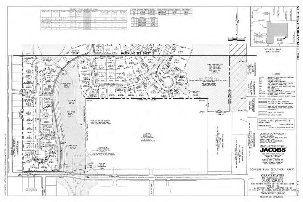
11 EXHIBIT C CONCEPTUAL LAND PLAN

12 EXHIBIT D SCREENING AND FENCING PLAN

13 EXHIBIT E AMENITY PLAN


14 EXHIBIT F ZONING DISTRICT MAP

15 EXHIBIT G PLANNED DEVELOPMENT CONCEPT PLAN
16
PLANNED DEVELOPMENT DISTRICT A ACRE TRACT KNOWN AS GEAN ESTATES CITY OF KELLER, TARRANT COUNTY TEXAS
 PLANNED DEVELOPMENT DISTRICT A 123.359 ACRE TRACT KNOWN AS GEAN ESTATES CITY OF KELLER, TARRANT COUNTY TEXAS A. Exhibit A Development Regulations B. Exhibit B Legal Description C. Exhibit C Conceptual
M E M O R A N D U M. Planning and Zoning Commission. Daniel Turner, Planner I
 M E M O R A N D U M Meeting Date: April 27, 2015 Item No. E-1 To: From: Planning and Zoning Commission Daniel Turner, Planner I Subject: Consider approval of a Final Plat for Gean Estates, Phase I, a proposed
LOCATION MAP: AERIAL PHOTOGRAPH, 2015:
 LOCATION MAP: AERIAL PHOTOGRAPH, 2015: ORDINANCE NO. AN ORDINANCE OF THE CITY OF BRYAN, TEXAS, AMENDING CHAPTER 130, ZONING, OF THE CITY OF BRYAN CODE OF ORDINANCES, BY CHANGING THE ZONING CLASSIFICATION
LOCATION MAP SHEET 1 OF 10
 OWNER: ADDRESS: LOCATION MAP CENTURY LAND HOLDINGS II, LLC 6500 RIVER PLACE BLVD. BUILDING 2, SUITE 200 AUSTIN, TX 78730 OWNER: CITY OF LEANDER ADDRESS: P.O. BOX 319 LEANDER, TX 78646 ACREAGE: LOTS ACREAGE:
$5,462 ($3,762, plus closing costs not to exceed
 4: Q i Jtwié9,21O A RESOLUTION DETERMINING UPON THE NECESSITY OF ACQUIRING REAL PROPERTY AND AUTHORIZING ITS APPROPRIATION AND/OR CONDEMNATION FOR A MUNICIPAL PURPOSE AND PUBLIC USE. DEFINITIONS: shall
GeoPoint 213 Hobbs Street Tampa, Florida
 AIRPORT ROAD PINELAND P.R.D. SUBDIVISION - PHASES 2 & 3 DESCRIPTION: A parcel of land lying in Sections 13 and 24, Township 14 South, Range 31 East, Volusia County, Florida, and being more particularly
applicant; and JBI Partners, Inc., surveyor /engineer; have submitted a planned
 1 2 3 4 5 6 7 8 10 11 13 14 151 16 1 22 23 24 25 26 27 ORDINANCE NO. 16 AN ORDINANCE OF THE CITY COUNCIL OF THE CITY OF KELLER, TEXAS, AMENDING THE UNIFIED DEVELOPMENT CODE OF THE CITY OF KELLER, TEXAS,
Honorable Mayor Bill Agan and members of the Richland Hills City Council. Final Plat Richland Hills, Lots 1 & 2, Block 1 Brumlow Addition
 2B - 1 Memorandum To: From: Date: Subject: Honorable Mayor Bill Agan and members of the Richland Hills City Council Jason Moore, Assistant City Manager January 17, 2017 Final Plat Richland Hills, Lots
ORDINANCE NO. Z REZONING NO
 ORDINANCE NO. Z- 3960 REZONING NO. 2018-00014 AN ORDINANCE RELATING TO ZONING: AMENDING CERTAIN ZONING REGULATIONS SHOWN ON SHEET NO. 15 OF THE ZONING DISTRICT MAP INCORPORATED BY REFERENCE BY OVERLAND
GeoPoint 1403 E. 5th Avenue Tampa, Florida
 AIRPORT ROAD PINELAND P.R.D. SUBDIVISION - PHASE 1 DEDICATION: CERTIFICATE OF REVIEW BY SURVEYOR, CITY OF ORMOND BEACH DEDICATION: THIS IS TO CERTIFY THAT FORESTAR (USA) REAL ESTATE GROUP INC., A DELAWARE
ORDINANCE NO (As Amended)
") ORDINANCE NO. 01-2015 (As Amended) To Amend the Official Zoning Map of the City of Worthington, Ohio, to Change Zoning of Certain Land from the C-3 District (Institutions and Office), AR-4.5 District (Low
ORDINANCE NO. 01-2015 (As Amended) To Amend the Official Zoning Map of the City of Worthington, Ohio, to Change Zoning of Certain Land from the C-3 District (Institutions and Office), AR-4.5 District (Low
property be rezoned from its classification of Planned Development-265( PD-265) District, Planned Development-
 District, Planned Development-") i ORDINANCE NO. 9952-2015 AN ORDINANCE OF THE CITY OF GRAND PRAIRIE, TEXAS, AMENDING THE ZONING ORDINANCE AND MAP BY SHOWING THE LOCATION, BOUNDARY, AND USE OF A CERTAIN PROPERTY GRANTING A ZONING CHANGE
i ORDINANCE NO. 9952-2015 AN ORDINANCE OF THE CITY OF GRAND PRAIRIE, TEXAS, AMENDING THE ZONING ORDINANCE AND MAP BY SHOWING THE LOCATION, BOUNDARY, AND USE OF A CERTAIN PROPERTY GRANTING A ZONING CHANGE
College Station, TX. Legislation Details (With Text) 3/23/2015 In control: City Council Regular 4/9/2015
 3/23/2015 In control: City Council Regular 4/9/2015") College Station, TX City Hall 1101 Texas Ave College Station, TX 77840 Legislation Details (With Text) File #: 15-0165 Version: 1 Name: Annexation Ordinance 233 Acres Type: Annexation Status: Agenda Ready
College Station, TX City Hall 1101 Texas Ave College Station, TX 77840 Legislation Details (With Text) File #: 15-0165 Version: 1 Name: Annexation Ordinance 233 Acres Type: Annexation Status: Agenda Ready
QUITCLAIM DEED CR 202 THE STATE OF TEXAS KNOW ALL MEN BY THESE PRESENTS: COUNTY OF WILLIAMSON
 QUITCLAIM DEED CR 202 THE STATE OF TEXAS KNOW ALL MEN BY THESE PRESENTS: COUNTY OF WILLIAMSON That WILLIAMSON COUNTY, TEXAS, hereinafter referred to as Grantor, whether one or more, for and in consideration
For the purposes of this resolution, the following definitions of terms
 COUNCIL CHAMBER February 23, 2011 A RESOLUTION DETERMINING UPON THE NECESSITY OF ACQUIRING REAL PROPERTY AND AUTHORIZING ITS APPROPRIATION ANDIOR CONDEMNATION FOR A MUNICIPAL PURPOSE AND PUBLIC USE. DEFINITIONS:
DALLAS WATER UTILITIES WATER/WASTEWATER COVENANT
 DALLAS WATER UTILITIES WATER/WASTEWATER COVENANT Procedure for obtaining a water and wastewater covenant, water covenant, or wastewater covenant; Required for initial submittal: 1. One letter from the
A portion of the land (surplus land), described in Exhibit A, is no longer needed for a state highway purpose.
, described in Exhibit A, is no longer needed for a state highway purpose.") TEXAS TRANSPORTATION COMMISSION DENTON County MINUTE ORDER Page 1 of 2 DALLAS District In the city of Northlake, DENTON COUNTY, on INTERSTATE 35W, the State of Texas (state) acquired certain land for a
TEXAS TRANSPORTATION COMMISSION DENTON County MINUTE ORDER Page 1 of 2 DALLAS District In the city of Northlake, DENTON COUNTY, on INTERSTATE 35W, the State of Texas (state) acquired certain land for a
Department of Development Services Engineering; Survey Plat Review Group SPRG
 Department of Development Services Engineering; Survey Plat Review Group SPRG CITY OF DALLAS LEGAL DESCRIPTION PREPARATION GUIDELINE AND CHECKLIST The following guideline and checklist are provided to
ORDINANCE NO LOCATED AT ROAD AND PROPERPT SOUTH TO 1-70 BETWEEN 23 ROAD AND BOOKCLIFF RANCHES SUBDIVISION
 RECEPTIONS 2859566 10/29/18 1:52:59 PM,1 of 11 Recording: $63.00, Sheila Reiner, Mesa County, CO. CITY OF GRAND JUNCTION, COLORADO CUERKAND RECORDER ORDINANCE NO. 4822 AN ORDINANCE AMENDING THE COMPREHENSIVE
WASTEWATER BACKFLOW RELEASE PROCEDURES
 WASTEWATER BACKFLOW RELEASE PROCEDURES PROCEDURE FOR OBTAINING A WASTEWATER RELEASE FOR PRIVATE DEVELOPMENT PROJECTS: PLEASE NOTE THAT THE WASTEWATER BACKFLOW RELEASE DOCUMENT MUST FOLLOW THE CITY S PROCEDURES.
to St. Louis County by deed recorded in Book 7954, Page 235 in the St. Louis County, Missouri
 Recommendation of Planning Commission BILL NO. 4032 ORDINANCE NO. 2015-3971 AN ORDINANCE ENACTING A CONDITIONAL USE PERMIT FOR AN ELECTRICAL SUBSTATION AT 11520 DORSETT ROAD Petition of Ameren Missouri)
ANDERSON HALL PUD TEXT AMENDMENT PRESENTED BY STEVEN D. HARDIN, ESQ.
 ANDERSON HALL PUD TEXT AMENDMENT PRESENTED BY STEVEN D. HARDIN, ESQ. TOWN COUNCIL REQUEST FOR THIRD READING MARCH 17, 2014 TABLE OF CONTENTS 141ST STREET & PROMISE ROAD PUD Petitioner Craig H. Lintner
Memorandum September 13, 2018
 Memorandum September 13, 2018 TO: FROM: Planning and Zoning Commission Julie Couch, Town Manager Israel Roberts, AICP Planning Manager SUBJECT: FINAL PLAT FOR THE EBERSOHL ADDITION BACKGROUND: This is
Synergy Park Addition (Companion to item 3)
") Synergy Park Addition (Companion to item 3) Attachments: 1. Locator 2. Replat staff report 3. Replat W P G r es rg eo e s Bu hh wy Lot 6A 4.02-acres Lot 4C 13.02-acres Fran k Lots 4C and 6A, Block A Synergy
Synergy Park Addition (Companion to item 3) Attachments: 1. Locator 2. Replat staff report 3. Replat W P G r es rg eo e s Bu hh wy Lot 6A 4.02-acres Lot 4C 13.02-acres Fran k Lots 4C and 6A, Block A Synergy
CITY OF ROCKWALL ORDINANCE NO
 CITY OF ROCKWALL ORDINANCE NO. 06-02 AN ORDINANCE OF CITY COUNCIL OF THE CITY OF ROCKWALL, TEXAS, AMENDING UNIFIED DEVELOPMENT CODE OF CITY OF ROCKWALL, AS PREVIOUSLY AMENDED, SO AS TO APPROVE A CHANGE
Ollor OSS/C;I(IJ-( ((?jg/\jl3
 01425 AFTER RECORDING RETURN TO: Tim Hagen Hagen & Parsons, P' C. North Central Plaza Three 12801 N. Central Expwy., Suite 370 Dallas, Texas 75243 Ollor OSS/C;I(IJ-( ((?jg/\jl3 04991.3 TENTH SUPPLEMENT
ORDINANCE NO AN ORDINANCE OF THE CITY OF SHENANDOAH, TEXAS, REPEALING ORDINANCE NO
 ORDINANCE NO. 0-16-010 AN ORDINANCE OF THE CITY OF SHENANDOAH, TEXAS, REPEALING ORDINANCE NO. 0-15-012 AND AMENDING THE CODE OF ORDINANCES, CITY OF SHENANDOAH, TEXAS, CHAPTER 102, SO AS TO REZONE 8. 624
An ordinance changing the zoning classification on the following properties:
 ORDINANCE NO. Page 9-27-16 An ordinance changing the zoning classification on the following properties: BEING Lots 1 through 5 in City Block C/7085 located at the southwest corner of Akron Street and McPherson
CERTIFIED SURVEY MAP
 SCONSIN STATE PLANE N:389676.12 E:2130390.15 Center of Section 23 CERTIFIED SURVEY MAP 734.06' THE (PRITCHETTE) ORIGINAL PLAT OF ALL IN THE NW 1 4 OF THE SE 1 4 OF FRACTIONAL SECTION 23, T7N, R9E, IN THE
ORDINANCE NO An ordinance changing the zoning classification on the following property:
 8-27-14 ORDINANCE NO. 2 9 4 3 1 An ordinance changing the zoning classification on the following property: BEING a tract of land in City Block 1/7675; fronting approximately 125 feet on the west line of
SPECIAL ZONING DISTRICTS
 SPECIAL ZONING DISTRICTS 5.01 5.99 RESERVED 5.100 PLANNED DEVELOPMENTS: Purpose: This district is intended to accommodate unified design of residential, commercial, office, professional services, retail
the City of Rockwall in compliance with the laws of the State of Texas and the ordinances of the City
 CITY OF ROCKWALL ORDINANCE NO. 14-50 AN ORDINANCE OF THE CITY COUNCIL OF THE CITY OF ROCKWALL, TEXAS, AMENDING THE UNIFIED DEVELOPMENT CODE ORDINANCE NO. 04-381 OF THE CITY OF ROCKWALL, AS HERETOFORE AMENDED,
DEVELOPMENT DEPARTMENT STAFF REPORT THE PARK AT 5 TH
 DEVELOPMENT DEPARTMENT STAFF REPORT ARB Meeting Date: July 3, 2018 Item #: _PZ2018-293_ THE PARK AT 5 TH Request: Site Address: Project Name: Parcel Number: Applicant: Proposed Development: Current Zoning:
VICINITY MAP SCALE 1'' = 2000'
 CITY CREEK ANNEXATION TO THE CITY OF THORNTON LOCATED IN THE SOUTHWEST QUARTER OF SECTION 11 AND THE WEST HALF OF SECTION 14, TOWNSHIP 1 SOUTH, RANGE 68 WEST OF THE 6TH PRINCIPAL MERIDIAN, COUNTY OF ADAMS,
ACTION FORM BRYAN CITY COUNCIL
 ACTION FORM BRYAN CITY COUNCIL DATE OF COUNCIL MEETING: July 8, 2014 DATE SUBMITTED: June 17, 2014 DEPARTMENT OF ORIGIN: Development Services SUBMITTED BY: Maggie Dalton MEETING TYPE: CLASSIFICATION: ORDINANCE:
ARTICLE 260. PD 260.
 ARTICLE 260. PD 260. SEC. 51P-260.101. LEGISLATIVE HISTORY. PD 260 was established by Ordinance No. 19403, passed by the Dallas City Council on December 3, 1986. Ordinance No. 19403 amended Ordinance No.
Avg. HH Income th Avenue Fort Worth, TX
 Site Available Southwest Corner of Old Decatur Road & W.J. Boaz Road PROPERTY SPECIFICATIONS: LOCATION: LAND SIZE: Southwest corner of Old Decatur Road & W.J. Boaz Road Approximately 1.46 Acres SITE ZONED:
Exhibit A-1. Piney Creek Bend Planned Development
 Exhibit A-1 Piney Creek Bend Planned Development A. Purpose and Intent The Piney Creek Bend PD is composed of approximately 90.91 acres, as described in Exhibit D (Field Notes). The development of this
SUBDIVISION APPLICATION
 SUBDIVISION APPLICATION Preliminary Plat Minor Plat Final Plat Amended Plat Applicant Name: Owner (if different from applicant) Name: Company: Company: Address: Address: City, State, Zip City, State, Zip
525 Yacht Club Road Oak Point, Texas p f
 ZONING VCM Prestonwood Polo Development, Ltd has re-zoned the 97.08 acre Prestonwood Polo Club property into 22 exclusive home sites overlooking lush 3 green polo fields. Careful attention has been paid
LISA ANDERSON-OGILVIE, AICP DEPUTY COMMUNITY DEVELOPMENT DIRECTOR AND PLANNING ADMINISTRATOR
 FOR MEETING OF: December 12, 2018 CASE NO.: VUL18-01 TO: FROM: HEARINGS OFFICER LISA ANDERSON-OGILVIE, AICP DEPUTY COMMUNITY DEVELOPMENT DIRECTOR AND PLANNING ADMINISTRATOR SUBJECT: VALIDATION OF UNIT
CONVEYANCE - COMMONWEALTH PROPERTY IN THE BOROUGH OF EAST STROUDSBURG, MONROE COUNTY Act of Jul. 1, 2016, P.L., No. 65 Cl.
 CONVEYANCE - COMMONWEALTH PROPERTY IN THE BOROUGH OF EAST STROUDSBURG, MONROE COUNTY Act of Jul. 1, 2016, P.L., No. 65 Cl. 85 An Act Authorizing the Department of General Services, with the approval of
Requirements for All Instruments of Conveyance in Logan County, Ohio
 Requirements for All Instruments of Conveyance in Logan County, Ohio Effective Date: April 11, 1997 It is the intent of these requirements to provide a standard method of checking legal descriptions for
As Introduced. 131st General Assembly Regular Session H. B. No
 131st General Assembly Regular Session H. B. No. 239 2015-2016 Representative Sears A B I L L To amend section 5120.092 and to enact section 5120.80 of the Revised Code to allow the Director of Budget
Restrictive Covenants for Belleau Woods Subdivision
 Restrictive Covenants for Belleau Woods Subdivision RESTRICTIVE COVENANTS FOR BELLEAU WOODS SUBDIVISION WHEREAS, the undersigned, STRUCTURAL DEVELOPMENT, LLC., a Tennessee Limited Liability Company (Hereinafter
EXISTING HIGHLAND HILLS PD-M DISTRICT DEVELOPMENT PLAN DRAWING:
 LOCATION MAP: EXISTING HIGHLAND HILLS PD-M DISTRICT DEVELOPMENT PLAN DRAWING: PROPOSED AMENDED HIGHLAND HILLS PD-M DISTRICT DEVELOPMENT PLAN DRAWING: ORDINANCE NO. AN ORDINANCE OF THE CITY OF BRYAN, TEXAS,
NOTICE OF THE REGULAR MEETING OF THE PLANNING & ZONING COMMISSION Tuesday, January 5, 2016 REGULAR MEETING AGENDA 6:30 PM
 NOTICE OF THE REGULAR MEETING OF THE PLANNING & ZONING COMMISSION Tuesday, January 5, 2016 Notice is hereby given of the Regular Meeting of the Planning & Zoning Commission beginning at 6:30 p.m. Tuesday,
APPLICATION FOR FINAL PLAT APPROVAL
 APPLICATION FOR FINAL PLAT APPROVAL Section 1. General. The undersigned Applicant (Applicant is synonymous with owner) makes this Application for Final Plat Approval in accordance with Chapter 21, Port
COUNCIL COMMUNICATION
 Meeting Date: October 24, 2017 COUNCIL COMMUNICATION Agenda Item: Agenda Location: Public Hearings Work Plan # Legal Review: X 1 st Reading 2 nd Reading Subject: A public hearing regarding Zoning and a
Article 12 PLATTING. ADOPTED: September 20, 2016 CASE NUMBER: TA ORDINANCE NO
 Article 12 PLATTING ADOPTED: September 20, 2016 CASE NUMBER: TA160701 ORDINANCE NO. 10130 2016 Unified Development Code Grand Prairie, Texas Planning Department Table of Contents Page No. Section 1 Purpose
DECLARATION OF COVENANTS, CONDITIONS, AND RESTRICTIONS FOR ROCK SPRINGS PREAMBLE
 DECLARATION OF COVENANTS, CONDITIONS, AND RESTRICTIONS FOR ROCK SPRINGS PREAMBLE This Declaration of Covenants, Conditions, and Restrictions is made on September 14, 2015, by Rock Springs, Ltd., acting
ORDINANCE NO. CID-3087
 ORDINANCE NO. CID-3087 AN ORDINANCE MAKING FINDINGS AS TO THE NATURE AND ADVISABILITY OF CREATING A COMMUNITY IMPROVEMENT DISTRICT AT THE NORTHEAST CORNER OF 91 ST STREET AND METCALF AVENUE; CREATING SAID
Auqust 27, For the purposes of this resolution, the following definitions of terms. shall apply: CITY : The City of Dallas
 COUNCIL CHAMBER Auqust 27, 2014 A RESOLUTION DETERMINING UPON THE NECESSITY OF ACQUIRING REAL PROPERTY AND AUTHORIZING ITS APPROPRIATION ANDOR CONDEMNATION FOR PUBLIC USE. DEFINITIONS: shall apply: For
PLANNING & ZONING COMMISSION Town of Little Elm
 PLANNING & ZONING COMMISSION Town of Little Elm Work Session and Regular Meeting Thursday, June 15, 2017 Town Hall - Council Chamber & Conference Room To address the Commission for any public hearing item
FINAL PLAT APPLICATION
 FINAL PLAT APPLICATION (Page 1 of 3) LEGAL OWNER(s): NAME: STREET ADDRESS OWNER(s): CITY, STATE, ZIP CODE: PHONE NUMBER: BILLING ADDRESS: NAME OF ENGINEER/SURVEYOR: Engineer/Surveyor Address, Phone: PROPERTY
PERSIMMON GROVE. Developer Pulte Group North Meridian Street, Suite 530 Carmel, IN 46032
 PERSIMMON GROVE A RESIDENTIAL PLANNED UNIT DEVELOPMENT In Avon, Indiana Developer Pulte Group 11590 North Meridian Street, Suite 530 Carmel, IN 46032 Attorney Comer Law Office Ben Comer 71 West Marion
1. APPLICANT: The City of Overland Park is the applicant for this request.
 8. UNIFIED DEVELOPMENT ORDINANCE AMENDMENT - ZRR 2590 - Residential Neighborhood District 1. APPLICANT: The City of Overland Park is the applicant for this request. 2. REQUESTED ACTION: The applicant is
PLANNING COMMISSION STAFF REPORT
 PLANNING COMMISSION STAFF REPORT Alder-Robinson Subdivision Amending the Amended Plat of the Arcadia Heights Plat A Subdivision Case #PLNSUB2010-00044 2857 East 2100 South June 23, 2010 Applicant: Greg
LAND USE PERMIT APPLICATION
 LAND USE PERMIT APPLICATION Date Application No. TYPE OF PERMIT Subdivision Short Plat Conditional Use Binding Site Plan Final Plat Final Short Plat Variance Final Binding Site Plan Plat Amendment Short
The City Council of the City of Sulphur, Louisiana, met in special session at its
 July 12, 2018 The City Council of the City of Sulphur, Louisiana, met in special session at its regular meeting place in the Council Chambers, Sulphur, Louisiana, on July 12, 2018 at 5:00 p.m., after full
named within the specified time period; and
 ORDINANCE NO. 27982 I An ordinance providing for the abandonment of portions of Crutcher (formerly Middleton) and Pauline Streets located adjacent to City Blocks A1840 and 837 in the City of Dallas and
COUNCIL AGENDA MEMO ITEM NO. III - #1
 COUNCIL AGENDA MEMO ITEM NO. III - #1 FROM: Anton Jelinek, Director of Utilities MEETING: October 24, 2017 SUBJECT: PRESENTER: Permanent Utility and Right-of-Way Easement Anton Jelinek Discussion: At the
ORDINANCE NO NOW, THEREFORE, BE IT ORDAINED BY THE CITY COUNCIL OF THE CITY OF MESQUITE, TEXAS:
 ORDINANCE NO. 31 55 AN ORDINANCE OF THE CITY OF MESQUITE, TEXAS ABANDONING, CERTAIN SIGN EASEMENTS LOCATED IN THE CREEK CROSSING AREA AT THE INTERSECTION OF CLAY MATHIS ROAD AND NEWSOM ROAD AND THE INTERSECTION
Grade: Curative Items: Non Curative Items:
 Order Details Title Company Information Property Address:31 Ann Street, Pottsville, PA 17901 Assigned Coordinator Details Escrow Officer: Email: closings@bntc.com Title Officer: Email: curative@bntc.com
M E M O R A N D U M. Meeting Date: October 23, Item No. F-1. Planning and Zoning Commission. Daniel Turner, Planner I
 M E M O R A N D U M Meeting Date: October 23, 2017 Item No. F-1 To: From: Subject: Planning and Zoning Commission Daniel Turner, Planner I PUBLIC HEARING: Consider a recommendation of a of Planned Development
PLANNING COMMISSION REPORT Regular Agenda Public Hearing Item PRD TO RM15; ACRES; 2101 EXCHANGE CT (KES)
") PC Staff Report 7/22/15 Z-14-00515 Item No. 3-1 PLANNING COMMISSION REPORT Regular Agenda Public Hearing Item PC Staff Report 7/22/15 ITEM NO. 3 PRD TO RM15; 9.818 ACRES; 2101 EXCHANGE CT (KES) Z-14-00515:
PC Staff Report 7/22/15 Z-14-00515 Item No. 3-1 PLANNING COMMISSION REPORT Regular Agenda Public Hearing Item PC Staff Report 7/22/15 ITEM NO. 3 PRD TO RM15; 9.818 ACRES; 2101 EXCHANGE CT (KES) Z-14-00515:
CITY OF OCALA CITY COUNCIL REPORT Council Meeting Date: 06/06/17
 CITY OF OCALA CITY COUNCIL REPORT Council Meeting Date: 06/06/17 Subject: Large Scale Land Use Map Amendment Submitted By: David Boston Department: Growth Management STAFF RECOMMENDATION (Motion Ready):
INVITATION FOR PROPOSALS SALE OF REAL PROPERTY INSTRUCTIONS, TERMS AND CONDITIONS
 INVITATION FOR PROPOSALS SALE OF REAL PROPERTY INSTRUCTIONS, TERMS AND CONDITIONS The City Council of the City of Covington invites members of the general public to submit sealed bid proposals to purchase
SUBDIVISION AND LAND DEVELOPMENT. 185 Attachment 20
 185 Attachment 20 APPENDIX S Plat No. Date of Submission Twp. Fee $ Dauphin Co. Fee $ TOWNSHIP OF DERRY SUBDIVISION OR LAND DEVELOPMENT PLAN SUBMISSION APPLICATION This block for Twp. use only 1. Title
ORDINANCE NO. BE IT ORDAINED BY THE CITY COUNCIL OF THE CITY OF DALLAS:
 ORDINANCE NO. * -1% L I An ordinance providing for the abandonment and relinquishment of a portion of a sanitary sewer easement located in City Block 1/818 in the City of Dallas and County of Dallas, Texas;
STANDARDS GOVERNING CONVEYANCES OF REAL PROPERTY IN DARKE COUNTY, OHIO
 STANDARDS GOVERNING CONVEYANCES OF REAL PROPERTY IN DARKE COUNTY, OHIO As directed by Section 319.203 of the Ohio Revised Code which states The County Auditor and the County Engineer shall adopt standards
Gas Well Setback Discussion
 Gas Well Setback Discussion City Council Work Session 04.24.18 Community and Neighborhood Development Committee 02.27.18 and 04.10.18 DEFINITIONS SETBACK REGULATION Protected Use (in Gas Drilling and Production
CITY OF PAPILLION MAYOR AND CITY COUNCIL REPORT MAY 16, 2018 AGENDA
 CITY OF PAPILLION MAYOR AND CITY COUNCIL REPORT MAY 16, 2018 AGENDA Subject: Type: Submitted By: A request to vacate the Final Plat for Prairie Queen First Subdivision, a subdivision legally described
ORDINANCE WHEREAS, the Planning and Zoning Board of the City of Belleview has been designated as the Local Planning Agency; and
 Page 1 of 9 ORDINANCE 2019-03 AN ORDINANCE OF THE CITY OF BELLEVIEW, FLORIDA RELATING TO AN AMENDMENT OF 8.87 +/- ACRES OF LAND TO THE CITY OF BELLEVIEW COMPREHENSIVE PLAN; AMENDING THE FUTURE LAND USE
ARTICLE 44. PD 44. Unless otherwise stated, the definitions and interpretations in Chapter 51 apply to this
 ARTICLE 44. PD 44. SEC. 51P-44.101. LEGISLATIVE HISTORY. PD 44 was established by Ordinance No. 13164, passed by the Dallas City Council on January 25, 1971. Ordinance No. 13164 amended Ordinance No. 10962,
City of Colleyville City Council Agenda Briefing
 City of Colleyville City Council Agenda Briefing City Hall 100 Main Street Colleyville, Texas 76034 www.colleyville.com Agenda Number 5a Agenda Date 01/06/2015 Number Ordinance O-14-1942 Type Ordinance
PLANNED DEVELOPMENT: MASTER PLAN (Preliminary Subdivision Plat)
") TOWN OF CLAYTON Planning Department 111 E. Second Street, Clayton, NC 27520 P.O. Box 879, Clayton, NC 27528 Phone: 919-553-5002 Fax: 919-553-1720 PLANNED DEVELOPMENT: MASTER PLAN (Preliminary Subdivision
TOWN OF CLAYTON Planning Department 111 E. Second Street, Clayton, NC 27520 P.O. Box 879, Clayton, NC 27528 Phone: 919-553-5002 Fax: 919-553-1720 PLANNED DEVELOPMENT: MASTER PLAN (Preliminary Subdivision
ABBREVIATION LEGEND SITE INFORMATION:
 SITE INFORMATION: Current Zone: R-3 PUD, governed by Fox Hollow 2nd MDA Basis of Elevations: Northeast Corner of Section 13, T6S, R1W, S.L.B. & M Elevation: 4599.26 (Benchmark) ABBREVIATION LEGEND Owners:
EASEMENT AGREEMENT. WHEREAS, Hall Brothers owns certain real property located in Weber County, Utah ( Hall Brothers Property );
;") When Recorded Return to: Parcel No. EASEMENT AGREEMENT THIS EASEMENT AGREEMENT ( Agreement ) is entered into this day of, 2016 by and between VALLEY DREAMS PROPERTIES, LLC, a Utah limited liability company
When Recorded Return to: Parcel No. EASEMENT AGREEMENT THIS EASEMENT AGREEMENT ( Agreement ) is entered into this day of, 2016 by and between VALLEY DREAMS PROPERTIES, LLC, a Utah limited liability company
AGENDA ITEM: VIII-A DATE: 04/06/17 APPLICANT: AR Sanchez, Jr. ENGINEER: Crane Engineering REQUEST: Review and consideration of the Southern Developmen
 AGENDA ITEM: VIII-A DATE: 04/06/17 APPLICANT: AR Sanchez, Jr. ENGINEER: Crane Engineering REQUEST: Review and consideration of the Southern Development Subdivision Master Plan. The intent is residential
Development Plan DP13-3 (Arlington Lofts) Planning and Zoning Meeting Date: Document Being Considered: Ordinance
 Planning and Zoning Meeting Date: Document Being Considered: Ordinance") Staff Report Development Plan DP13-3 (Arlington Lofts) Planning and Zoning Meeting Date: 6-19-13 Document Being Considered: Ordinance RECOMMENDATION Following the public hearing, consider Development Plan
Staff Report Development Plan DP13-3 (Arlington Lofts) Planning and Zoning Meeting Date: 6-19-13 Document Being Considered: Ordinance RECOMMENDATION Following the public hearing, consider Development Plan
ACTION FORM BRYAN CITY COUNCIL
 ACTION FORM BRYAN CITY COUNCIL DATE OF COUNCIL MEETING: July 28, 2015 DATE SUBMITTED: June 24, 2015 DEPARTMENT OF ORIGIN: Development Services SUBMITTED BY: Matthew Hilgemeier MEETING TYPE: CLASSIFICATION:
NOTICE OF FORECLOSURE SALE
 NOTICE OF FORECLOSURE SALE FILED TARRANT COUNTY TEXAS 2018 SEP 11 PH 3: ~9 Notice is hereby given of a public nonjudicial foreclosure sale. M R Lr l~ L ARCIA COUNTY Cl.ERK 1. Property To Be Sold. The property
CITY OF WACONIA RESOLUTION
 CITY OF WACONIA RESOLUTION 2014-212 TOWNSHIP OF LAKETOWN RESOLUTION~~- \0 JOINT RESOLUTION STIPULATING TO THE AMENDMENT OF ORDERLY ANNEXATION AGREEMENT NO. 76-47 AND TO THE ORDERLY ANNEXATION OF THE RYLAND
FIFTH AMENDMENT OF DECLARATION OF DEED RESTRICTIONS AND DEDICATIONS FOR PINEHURST ESTATES (A Clatsop County, Oregon Subdivision)
") After Recording Return To: W. Louis Larson 990 Astor Street Astoria, OR 97103 FIFTH AMENDMENT OF DECLARATION OF DEED RESTRICTIONS AND DEDICATIONS FOR PINEHURST ESTATES (A Clatsop County, Oregon Subdivision)
After Recording Return To: W. Louis Larson 990 Astor Street Astoria, OR 97103 FIFTH AMENDMENT OF DECLARATION OF DEED RESTRICTIONS AND DEDICATIONS FOR PINEHURST ESTATES (A Clatsop County, Oregon Subdivision)
Planning Commission Application Summary
 Planning Commission Application Summary Project Name: Academy Office Park Plat Amendment Request Address: 339 West 13490 South Current Zoning: CSD-DPMU Hearing Date: August 11, 2016 Summary of Request
Village of Mantua, Ohio ORDINANCE
 AN ORDINANCE AUTHORIZING THE MAYOR TO EXECUTE A LEASE / OPTION TO PURCHASE AGREEMENT WITH THE PORTAGE PARK DISTRICT FOR THE HEADWATERS TRAIL WEST OF STATE ROUTE 44, AND DECLARING AN EMERGENCY. WHEREAS,
COUNCIL ACTION FORM VACATION AND CONVEYANCE OF APPLE PLACE AND PEACH LANE RIGHT-OF-WAY TO THE OLD ORCHARD/CREEKSIDE MOBILE HOME PARK
 ITEM # 21&22 DATE: 03-27-18 COUNCIL ACTION FORM SUBJECT: VACATION AND CONVEYANCE OF APPLE PLACE AND PEACH LANE RIGHT-OF-WAY TO THE OLD ORCHARD/CREEKSIDE MOBILE HOME PARK BACKGROUND: City of Ames staff
AGENDA UPDATE ECONOMIC DEVELOPMENT & FINANCE STANDING COMMITTEE MEETING MONDAY, AUGUST 10, 2015 III. COMMITTEE AGENDA
 AGENDA UPDATE ECONOMIC DEVELOPMENT & FINANCE STANDING COMMITTEE MEETING MONDAY, AUGUST 10, 2015 III. COMMITTEE AGENDA REVISED ITEM NO. 4 150217.ORDINANCE: VACATION VILLAGE AREAS 1 AND 2A Synopsis: A revised
1. Action taken on the Planning & Zoning Commission items by City Council at the February 27, 2018, regular meeting.
 AGENDA CITY OF ALLEN PLANNING AND ZONING COMMISSION REGULAR MEETING TUESDAY, MARCH 6, 2018 7:00 P.M. CITY COUNCIL CHAMBERS ALLEN CITY HALL 305 CENTURY PARKWAY ALLEN, TEXAS 75013 Call to Order and Announce
FLATS AT 146. Replat and Amendment to a Multi-family Planned Development DOMO DEVELOPMENT, LLC PRESENTED BY STEVEN D. HARDIN, ESQ.
 Replat and Amendment to a Multi-family Planned Development DOMO DEVELOPMENT, LLC PRESENTED BY STEVEN D. HARDIN, ESQ. NOBLESVILLE PLAN COMMISSION JUNE 16, 2014 TABLE OF CONTENTS Petitioner DOMO Development
ORDINANCE N0.18-ll6. WHEREAS, City has prepared a Service Plan for said tract which is attached as Exhibit "A" to this ordinance; &
 c: 0 ORDINANCE N0.18-ll6 AN ORDINANCE ANNEXING THE HEREINAFTER DESCRIBED TERRITORY TO THE CITY OF FORT STOCKTON, PECOS COUNTY, TEXAS, AND EXTENDING THE BOUNDARY LIMITS OF SAID CITY SO AS TO INCLUDE SAID
CLARK 3925 E. US 377 COMMERCIAL $699,000 COMMERCIAL PAD SITE IN FRONT OF NEW KROGER. Granbury, Texas
 PAD SITE IN FRONT OF NEW KROGER $699,000 1.858 Acres Monument sign on 377 377 road frontage Platted Zoned Utilities to the site PROPERTY INFORMATION Property Information: Adjacent to recently opened Kroger
PLANNED DEVELOPMENT DISTRICT STANDARDS. Cadence Site
 PLANNED DEVELOPMENT DISTRICT STANDARDS Cadence Site A Planned Development District 1. Statement of General Facts, Conditions and Objectives Property Size: Approximately 57.51 Acres York County Tax Map
RESOLUTION NO WHEREAS, William Parrott and Peggy Parrott, his wife ("Applicants"), the owners of
, the owners of") ". fcf 1 Resolution 595 Page 1 INSTR # 1696524 OR BK 1822 PG 717 RECORDED 9/3/23 11:12:41 AM MARSHA EWING CLERK OF MARTIN COUNTY FLORIDA RECORDED BY C Burkey RESOLUTION NO. 595 A RESOLUTION OF THE TOWN
". fcf 1 Resolution 595 Page 1 INSTR # 1696524 OR BK 1822 PG 717 RECORDED 9/3/23 11:12:41 AM MARSHA EWING CLERK OF MARTIN COUNTY FLORIDA RECORDED BY C Burkey RESOLUTION NO. 595 A RESOLUTION OF THE TOWN
ORDINANCE NO AN ORDINANCE To Be Entitled:
 3808 AN ORDINANCE To Be Entitled: AN ORDINANCE OF THE CITY COUNCIL OF THE CITY OF FORT MYERS, FLORIDA, REZONING FROM COMMERCIAL GENERAL TO PLANNED UNIT DEVELOPMENT AND APPROVING THE DEVELOPMENT PLAN FOR
ORDINANCE NO. An ordinance providing for the abandonment and relinquishment of portions of three
 Dallas, Texas; providing for the quitclaim thereof to ATA Apartments Limited An ordinance providing for the abandonment and relinquishment of portions of three ORDINANCE NO. 2 90 7 7 storm sewer easements
REPORT TO PLANNING & ZONING COMMISSION - CITY OF MARYLAND HEIGHTS
 APPLICATION NUMBER APPLICATION (PROJECT) NAME APPLICANT NAME PROPERTY OWNER NAME CUP16-0013 POHLMAN, LLC Pohlman, LLC 140 Long Road, Chesterfield, Missouri 63005 JDDC, Ltd. 8677 Tyler Boulevard, Mentor,
BY BOARD OF COUNTY COMMISSIONERS
 BY BOARD OF COUNTY COMMISSIONERS ORDINANCE NO. AN ORDINANCE CREATING THE PLANTATION PALMS MUNICIPAL SERVICE BENEFIT UNIT; PROVIDING FOR BOUNDARIES; PROVIDING FOR LEVY OF NON AD-VALOREM SPECIAL ASSESSMENTS;
NOW, THEREFORE BE IT ORDAINED,
 ORDINANCE 2087 AN ORDINANCE OF THE BOROUGH OF SOUTH PLAINFIELD, COUNTY OF MIDDLESEX, AND STATE OF NEW JERSEY, AMENDING AND SUPPLEMENTING CHAPTER 540, ENTITLED ZONING, OF THE CODE OF THE BOROUGH OF SOUTH