Mingo County, WV Community Coordination Preliminary Flood Insurance Study and Flood Insurance Rate Map. Thursday, September 25, 2014
|
|
|
- Samantha Hensley
- 5 years ago
- Views:
Transcription


1 Mingo County, WV Community Coordination Preliminary Flood Insurance Study and Flood Insurance Rate Map Thursday, September 25, 2014
2 Overview Preliminary Materials Preliminary FIS Report Digital Flood Insurance Rate Map (DFIRM) Preliminary FIRM Levee Seclusion Preliminary SOMA Flood Hazard Mapping Fact Sheet
 Report hard")
 panels - hard copy")
3 Preliminary Materials Flood Insurance Study (FIS) Report hard copy and digital Flood Insurance Rate Map (FIRM) panels - hard copy and digital
4 Preliminary Materials (continued) Preliminary Summary of Map Actions (SOMA) Flood Hazard Mapping Fact Sheet
5 Preliminary FIS Report FIS report narrative includes all revised Tug Fork study data within the county, including the following revised tables and exhibits: Summary of Discharges Table Manning s n Values Table Flood Profiles and Floodway Data Tables Tug Fork (entire reach in county) Buffalo Creek, Laurel Fork, Marrowbone Creek, Mate Creek, and Pigeon Creek, Trace Fork, West Fork Twelvepole Creek (backwater reaches)
6 Preliminary FIS Report - Hydrologic and Hydraulic Analyses Tug Fork and detailed study tributaries New detailed hydrologic and hydraulic analyses have been performed, replacing all previously effective detailed stream reaches as part of this update In general, Base Flood Elevations (BFEs) have been reduced along Tug Fork and impacted tributaries, resulting in reduced flood hazard areas

7 Preliminary FIS Report Floodway Concept


 Base")

8 Components of a Digital Flood Insurance Rate Map (DFIRM) Base + New Topography (LiDAR) + GIS Flood Data = DFIRM

![shown at 200%] Effective Floodplain (FIRM 0139F), Tug Fork and](/docs-images/96/128198903/images/9-2.jpg "Miller Creek map scale shown at 1 = 500 [note: above image is")
9 Preliminary FIRM Effective Floodplain (FIRM 0140E), Tug Fork and Miller Creek map scale shown at 1 = 1,000 [note: above image is shown at 200%] Effective Floodplain (FIRM 0139F), Tug Fork and Miller Creek map scale shown at 1 = 500 [note: above image is shown at 100%]
10 Preliminary FIRM Updates Detailed floodplains Tug Fork New detailed hydrologic and hydraulic analyses for 66.9 miles Boundaries were re-delineated for Tug Fork, based upon updated topographic data (LiDAR) Portions of boundaries in the backwater areas were revised to tie-in with detailed study streams: Buffalo Creek, Laurel Fork, Marrowbone Creek, Mate Creek, and Pigeon Creek, Trace Fork, West Fork Twelvepole Creek Data developed as part of Tug Fork Watershed Discovery project, located in West Virginia, Kentucky, and Virginia (9 counties & 15 cities/towns)
11 Preliminary FIRM Updates (continued) Zone A (approximate) floodplains Preliminary FIRM Database will include model-backed cross section data for the county No updated approximate analyses Base map combined with floodplain data Improves accuracy of floodplain determinations
12 Preliminary FIRM Updates (continued) GIS based, county-wide format Preliminary DFIRM Shapefiles (SFHA, floodway, cross-sections, BFEs, maps, political boundaries, etc.) This is preliminary data that may be subject to appeal, and cannot be used for making final determinations. The data can be used for demonstration purposes only and cannot be distributed or published without the consent of FEMA. Helpful for reviewing with your community s GIS data

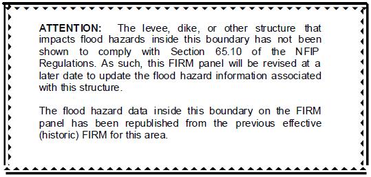
13 Levee Seclusion
14 Levee Seclusion Non-Accredited Levees Tug Fork s 3 Impacted Levee Systems Shown on FIRM panels 0216F, 0217F, and 0331F Affects the City of Williamson and the Town of Matewan Flood hazard information is shown as a snapshot of the prior (October 2, 2012) effective information NFIP requirements of 44 CFR Section must be met for levee accreditation Upon accreditation, flood hazard information will be mapped upon the latest Tug Fork analyses, and the levee seclusion notation removed from the FIRM panels
15 Preliminary SOMA Background Letters of Map Change (LOMCs) are legally binding changes to the map Many LOMCs are not incorporated in the new maps due to map scale constraints SOMAs assess all valid LOMCs compared against the new FEMA study Category 1: shown on the new FIRM panel Category 2: not shown on the new FIRM panel due to map scale limitations (revalidated after the new FIRMs become effective) Category 3: superseded, and no longer valid, due to revised flood hazards Category 4: must be re-determined
16 Flood Hazard Mapping Fact Sheet Summarizes information about the NFIP and how the new study data was developed Answers common questions related to the new maps Provides a generalized mapping process timeline
MAP INDEX CHECKLIST NOTES:
 REVIEWING YOUR PRELIMINARY DFIRM PANELS AND FIS REPORT A GUIDE FOR COMMUNITY OFFICIALS When a Georgia community is presented with new Digital Flood Insurance Rate Map (DFIRM) panels, the State of Georgia,
Letter of Map Change Fundamentals
 Letter of Map Change Fundamentals FEMA Region III National Flood Insurance Program Essentials and Best Practices Jana Green, CFM, RAMPP Topics of Discussion Why Apply for a Letter of Map Change (LOMC)?
Map Modernization State Business Plan for Ohio January 2004 Attachment #2
 Map Modernization State Business Plan for Ohio January 2004 Attachment #2 FEDERAL EMERGENCY MANAGEMENT AGENCY COOPERATING TECHNICAL PARTNERS MEMORANDUM OF AGREEMENT AGREEMENT is made on April 22, 2003,
Criteria for Appeals of Flood Insurance Rate Maps. November 30, 201 1
 Criteria for Appeals of Flood Insurance Rate Maps November 30, 201 1 This document outlines the criteria for appealing proposed changes in flood hazard information on Flood Insurance Rate Maps (FIRMS)
FEMA Map Modernization in Oklahoma
 FEMA Map in Oklahoma Oklahoma Floodplain Management Association Tulsa, Oklahoma Jerry Clark, P.E., RMC VI September 18, 2007 Introduction Accurate information about risks is the first step in preventing
Map Modernization Modernization Program
 FEMA Map Modernization Program Presented to Maryland Association of Floodplain and Stormwater Managers October 27, 2005 Map Modernization Program Autorun.exe 2 Map Modernization Program Outline Map Mod
HEC Software and FEMA Submittals
 HEC Software and FEMA Submittals EWRI Workshop HEC Users Conference Larry Voice Risk Analysis FEMA Region VI April 12, 2010 Overview Flood Hazard Analysis Overview of Map Changes Accepted Model List Guidance
Letters of Map Amendment- Out as Shown
 Letters of Map Amendment- Out as Shown While digital Flood Insurance Rate Maps (DFIRM s) have made it easier to determine if a structure (or building site) is in the special flood hazard area (SFHA), many
Final Report WI Flood Map Maintenance Project. Prepared For. The Wisconsin Department of Natural Resources Flood Map Maintenance Project
 Final Report WI Flood Map Maintenance Project Prepared For The Wisconsin Department of Natural Resources Flood Map Maintenance Project December 2007 TABLE OF CONTENTS INTRODUCTION 1 GIS DATA INVENTORY
FEMA POLICY: GUIDANCE ON THE USE OF AVAILABLE FLOOD HAZARD INFORMATION
 FEMA POLICY: GUIDANCE ON THE USE OF AVAILABLE FLOOD HAZARD INFORMATION FEMA Policy #104-008-2 BACKGROUND The policy is for FEMA Headquarters, Regional program staff, and for the Field Staff at the Joint
2016 Fredericksburg Area Floodplain Management Workshop Tuesday, October 25, 2016
 2016 Fredericksburg Area Floodplain Management Workshop Tuesday, October 25, 2016 Charley Banks, CFM Department of Conservation And Recreation Division of Dam Safety & Floodplain Management Some Soapbox
BEAVER COUNTY, PENNSYLVANIA
 VOLUME 3 OF 3 BEAVER COUNTY, PENNSYLVANIA (ALL JURISDICTIONS) Beaver County COMMUNITY NAME COMMUNITY NUMBER COMMUNITY NAME COMMUNITY NUMBER ALIQUIPPA, CITY OF 420101 AMBRIDGE, BOROUGH OF 420102 BADEN,
Project Name: (Name as it appears in ESNAPS.) Spring Care Association
 Spring Care Association") Page 1 of 4 U.S. Department of Housing and Urban Development 451 Seventh Street, SW Washington, DC 20410 www.hud.gov espanol.hud.gov Environmental Review for Continuum of Care (CoC) Rental Assistance Project
Page 1 of 4 U.S. Department of Housing and Urban Development 451 Seventh Street, SW Washington, DC 20410 www.hud.gov espanol.hud.gov Environmental Review for Continuum of Care (CoC) Rental Assistance Project
Floodplain Management: New York State Role
 Floodplain Management: New York State Role Establish development/building standards State building code Model local law for flood damage prevention Provide technical assistance to local communities/agencies
National Flood Insurance Program
 National Flood Insurance Program Base Flood Elevations in Zone A Streams Surveyor Training Presented by Thomas F. Smith, PE, PLS January 22, 2018 1 FEMA Region III Mitigation Division Floodplain Management
CITY OF CAMBRIDGE FLOODPLAIN MANAGEMENT CHAPTER 7 (GRADING, EROSION AND SEDIMENT CONTROL)
") CITY OF CAMBRIDGE FLOODPLAIN MANAGEMENT CHAPTER 7 (GRADING, EROSION AND SEDIMENT CONTROL) City of Cambridge, MD Floodplain Management Ordinance (Tidal): May, 2011 1 City of Cambridge, Maryland Floodplain
CITY OF CAMBRIDGE FLOODPLAIN MANAGEMENT CHAPTER 7 (GRADING, EROSION AND SEDIMENT CONTROL) City of Cambridge, MD Floodplain Management Ordinance (Tidal): May, 2011 1 City of Cambridge, Maryland Floodplain
[Docket ID FEMA ; Internal Agency Docket No. FEMA-B-1808] AGENCY: Federal Emergency Management Agency, DHS.
![[Docket ID FEMA ; Internal Agency Docket No. FEMA-B-1808] AGENCY: Federal Emergency Management Agency, DHS.](/thumbs/82/86021413.jpg "[Docket ID FEMA ; Internal Agency Docket No. FEMA-B-1808] AGENCY: Federal Emergency Management Agency, DHS.") This document is scheduled to be published in the Federal Register on 03/16/2018 and available online at https://federalregister.gov/d/2018-05415, and on FDsys.gov 1 Billing Code 9110-12-P DEPARTMENT OF
This document is scheduled to be published in the Federal Register on 03/16/2018 and available online at https://federalregister.gov/d/2018-05415, and on FDsys.gov 1 Billing Code 9110-12-P DEPARTMENT OF
What s New in FEMA Mapping?
 Discussion Topics What s New in FEMA Mapping? Eric Simmons September 6, 2018 FEMA Initiatives & Evolving Risk MAP FEMA s Flood Map Service Center National Flood Hazard Layer (NFHL) Draft NFHL and Changes
Oxford Floodplain Management Ordinance
 Table of Contents SECTION 1.0 GENERAL PROVISIONS...1 1.1 Findings...1 1.2 Statutory Authorization...1 1.3 Statement of Purpose...1 1.4 Areas to Which These Regulations Apply...2 1.5 Basis for Establishing
Date of Review: 11/6/2015 Reviewer: RCQ/LMC STATE
 FINAL Florida Review Checklist: NFIP & FBC & Revised Model Ordinance (January 15, 2013d) Ordinance Citation: Model FPM regulations and 5 th Edition FBC : All Zones Date of Review: 11/6/2015 Reviewer: RCQ/LMC
MT 1, MT 2, Elevation Certificates & the Role of Surveyors
 MT 1, MT 2, Elevation Certificates & the Role of Surveyors Rocky Mountain Surveyors Summit March 3, 2016 Floods are acts of God, but flood losses are largely acts of man. - Dr. Gilbert White the father
Chapter 5. Floodplain Management. 5.0 Introduction. 5.1 Douglas County Comprehensive Master Plan. 5.2 Floodplain Management and Regulation
 5.0 Introduction This chapter summarizes the County s rules and regulations regarding floodplain management and development. The requirements presented in this chapter should be used by the design engineer
AGENCY: Federal Emergency Management Agency, DHS. SUMMARY: Comments are requested on proposed flood hazard determinations, which
 This document is scheduled to be published in the Federal Register on 02/05/2013 and available online at http://federalregister.gov/a/2013-02455, and on FDsys.gov 1 Billing Code 9110-12-P DEPARTMENT OF
[Docket ID FEMA ; Internal Agency Docket No. FEMA-B AGENCY: Federal Emergency Management Agency, DHS.
 This document is scheduled to be published in the Federal Register on 09/25/2017 and available online at https://federalregister.gov/d/2017-20468, and on FDsys.gov 1 Billing Code 9110-12-P DEPARTMENT OF
SECTION 10: FLOOD HAZARD EVALUATION 10-1
 10) SECTION 10: FLOOD HAZARD EVALUATION A. General. Land subject to being flooded by a Flood of 100-Year Frequency as defined by Title 76, Chapter 5, MCA, or land subject to flooding pursuant to these
Chapter 5. Floodplain Management. 5.0 Introduction. 5.1 Floodplain Management and Regulation
 5.0 Introduction This chapter summarizes the Town s rules and regulations regarding floodplain management and development. The requirements presented in this chapter should be used by the design engineer
Federal Emergency Management Agency
 Page 1 of 3 Date: July 21, 2016 Case No.: 16-05-5203A LOMA COMMUNITY AND MAP PANEL INFORMATION COMMUNITY KEWAUNEE COUNTY, WISCONSIN (Unincorporated Areas) Federal Emergency Management Agency Washington,
Residential Major Subdivision Review Checklist
 Residential Major Subdivision Review Checklist Plan Submittal Requirements: 2 full sets of stamped plans Electric submittal - all plans contained in a single PDF 3 full sets if commercial kitchen or dining
YAVAPAI COUNTY FLOOD CONTROL DISTRICT FEMA WORKSHOP SEMINAR. November 1 st, 2016
 YAVAPAI COUNTY FLOOD CONTROL DISTRICT FEMA WORKSHOP SEMINAR November 1 st, 2016 1 Yavapai County Flood Control District YCFCD first adopted its Flood Damage Prevention Ordinance in 1981 Responsible for:
ARMSTRONG COUNTY, PENNSYLVANIA
 ARMSTRONG COUNTY, PENNSYLVANIA (ALL JURISDICTIONS) Armstrong County COMMUNITY NAME COMMUNITY NUMBER APOLLO, BOROUGH OF 420092 APPLEWOLD, BOROUGH OF 420093 ATWOOD, BOROUGH OF 422297 BETHEL, TOWNSHIP OF
Floodplain Development Land Use Review
 PUBLIC WORKS - COMMUNITY DEVELOPMENT 333 Broadalbin Street SW, PO Box 490, Albany, Oregon 97321-0144 BUILDING 541-917-7553 PLANNING 541-917-7550 Floodplain Development Land Use Review Application Information
[Docket ID FEMA ; Internal Agency Docket No. FEMA-B-1751] AGENCY: Federal Emergency Management Agency, DHS.
![[Docket ID FEMA ; Internal Agency Docket No. FEMA-B-1751] AGENCY: Federal Emergency Management Agency, DHS.](/thumbs/87/95259803.jpg "[Docket ID FEMA ; Internal Agency Docket No. FEMA-B-1751] AGENCY: Federal Emergency Management Agency, DHS.") This document is scheduled to be published in the Federal Register on 10/26/2017 and available online at https://federalregister.gov/d/2017-23228, and on FDsys.gov 1 Billing Code 9110-12-P DEPARTMENT OF
This document is scheduled to be published in the Federal Register on 10/26/2017 and available online at https://federalregister.gov/d/2017-23228, and on FDsys.gov 1 Billing Code 9110-12-P DEPARTMENT OF
Residential Minor Subdivision Review Checklist
 Residential Minor Subdivision Review Checklist Plan Submittal Requirements: 2 full sets of stamped plans Electric submittal - all plans contained in a single PDF 3 full sets if commercial kitchen or dining
National Flood Insurance Program (NFIP) MT-1 Presentation. David Mummert, Michael Baker Jr., Inc.
 MT-1 Presentation. David Mummert, Michael Baker Jr., Inc.") National Flood Insurance Program (NFIP) MT-1 Presentation David Mummert, Michael Baker Jr., Inc. MT-1 Letters of Map Change (LOMCs) LOMC Review By FEMA FEMA required to notify the applicant in writing
National Flood Insurance Program (NFIP) MT-1 Presentation David Mummert, Michael Baker Jr., Inc. MT-1 Letters of Map Change (LOMCs) LOMC Review By FEMA FEMA required to notify the applicant in writing
Alberta Flood Hazard Identification Program
 Alberta Flood Hazard Identification Program Peter Onyshko, P.Eng., CFM River Forecast Section Alberta Environment and Parks November 5, 2015 Flood Hazard Identification Program Presentation Outline Introduction
DIVISION 1. - GENERAL PROVISIONS
 Sec. 90-708. - Statutory authorization and purpose. Sec. 90-709. - Applicability. Sec. 90-710. - Compliance and liability. Sec. 90-711. - Records. Sec. 90-712. - Abrogation and greater restrictions. Sec.
Appendix A Reproducible Forms
 Appendix A Reproducible Forms Form LD-33 LD-34 LD-35 LD-40 LD-41 LD-42 LD-50 LD-51 LD-52 LD-53 Subject County Engineer Approval Form Storm Sewer Computation Sheet Ohio Drainage Design Criteria Form Gutter
1/23/2017. Floodplain Update For Surveyors. Floodplain Updates For Surveyors. Sample FEMA Map with SFHA
 Floodplain Updates For Surveyors Ceil Strauss MN State Floodplain Manager February 9, 2017 Floodplain Update For Surveyors Finding FEMA Maps & Data Map / Data Updates & Status Other useful resources Letters
MASON COUNTY FLOODPLAIN ORDINANCE
 MASON COUNTY FLOODPLAIN ORDINANCE September 2013 AUTHORITY AND PURPOSE: AN ORDINANCE ESTABLISHING A FLOODPLAIN AREA AND REQUIRING ALL CONTRACTORS, PERSONS, PARTNERSHIPS, BUSINESSES, AND CORPORATIONS TO
REQUEST FOR PROPOSALS
 REQUEST FOR PROPOSALS DAM BREAK INUNDATION ZONE STUDY AND MAPPING Town of Woodstock, VA The Town of Woodstock, Virginia is requesting proposals from engineering firms to perform Dam Break Inundation Studies
[Docket ID FEMA ; Internal Agency Docket No. FEMA-B-1800] AGENCY: Federal Emergency Management Agency, DHS.
![[Docket ID FEMA ; Internal Agency Docket No. FEMA-B-1800] AGENCY: Federal Emergency Management Agency, DHS.](/thumbs/87/97234219.jpg "[Docket ID FEMA ; Internal Agency Docket No. FEMA-B-1800] AGENCY: Federal Emergency Management Agency, DHS.") This document is scheduled to be published in the Federal Register on 01/24/2018 and available online at https://federalregister.gov/d/2018-01216, and on FDsys.gov 1 Billing Code 9110-12-P DEPARTMENT OF
This document is scheduled to be published in the Federal Register on 01/24/2018 and available online at https://federalregister.gov/d/2018-01216, and on FDsys.gov 1 Billing Code 9110-12-P DEPARTMENT OF
Carson River Floodplain Protection Progress Map, 2014 A project of the River Corridor Working Group. University of Nevada Cooperative Extension
 Carson River Floodplain Protection Progress Map, 2014 A project of the River Corridor Working Group of the CRC by Steve Lewis and John Cobourn University of Nevada Cooperative Extension Premise Protect
Overview of Federal and State Floodplain Management Programs
 Overview of Federal and State Floodplain Management Programs Peter DeMeo, PE Supervising Environmental Engineer New Jersey Department of Environmental Protection Division of Land Use Regulation October
RISK ASSESSMENT APPENDIX E HAZARD ANALYSIS RESULTS
 RISK ASSESSMENT E0 APPENDIX E HAZARD ANALYSIS RESULTS E1 NORTHUMBERLAND COUNTY HMP RISK ASSESSMENT E2 APPENDIX E HAZARD ANALYSIS RESULTS Summary Nearly ninety percent of federal disaster declarations are
WAYNE COUNTY, WV FLOODPLAIN ORDINANCE
 WAYNE COUNTY, WV FLOODPLAIN ORDINANCE AUTHORITY AND PURPOSE: AN ORDINANCE ESTABLISHING A FLOODPLAIN AREA AND REQUIRING ALL CONTRACTORS, PERSONS, PARTNERSHIPS, BUSINESSES, AND CORPORATIONS TO OBTAIN A PERMIT
2412 E. 26TH ST E 26th St, Minneapolis, MN 55406
 SALE PRICE: $425,000 LOT SIZE:.17 Acres BUILDING SIZE: +/-2,400 SF DRIVE-IN DOORS 1 CEILING HEIGHT: 14' YEAR BUILT: 1970 ZONING: I2 Medium Industrial District PROPERTY OVERVIEW Small shop, flexible office
Appendix H REPETITIVE LOSS PLAN
 Appendix H REPETITIVE LOSS PLAN Sacramento County Appendix H.1 Local Hazard Mitigation Plan Update August 2011 AREA #1 DRY CREEK Elkhorn Blvd East of Rio Linda Blvd PAST FLOOD EVENTS: MAY 1983; FEBRUARY
JACKSON COUNTY DEVELOPMENT RULES, REGULATIONS AND PROTOCOLS Non-Commercial Structures
 JACKSON COUNTY DEVELOPMENT RULES, REGULATIONS AND PROTOCOLS Non-Commercial Structures Mission Statement: We are first a public agency, funded by public tax dollars. Our fundamental mission is to protect
AGENCY: Federal Emergency Management Agency, DHS. SUMMARY: Comments are requested on proposed flood hazard determinations, which
 This document is scheduled to be published in the Federal Register on 05/13/2014 and available online at http://federalregister.gov/a/2014-11002, and on FDsys.gov 1 Billing Code 9110-12-P DEPARTMENT OF
Overview of CRS reward program - discounts for communities going above and beyond the minimal NFIP, class 9-5%, class 8-10% discount administered by
 Overview of CRS reward program - discounts for communities going above and beyond the minimal NFIP, class 9-5%, class 8-10% discount administered by ISO - corporation based out of New Jersey goals - strengthen
ORD-3309 BE IT ORDAINED BY THE CITY COUNCIL OF THE CITY OF VIRGINIA BEACH, VIRGINIA:
 ORD-3309 1 2 3 4 5 6 7 8 9 10 11 12 13 14 15 16 17 18 19 20 21 22 23 24 25 26 27 28 29 30 31 32 33 34 35 36 37 38 39 40 41 42 43 44 45 AN ORDINANCE TO ADOPT APPENDIX K, (FLOODPLAIN ORDINANCE) OF THE CITY
FLOOD HAZARD AREA LAND USE MANAGEMENT
 FLOOD HAZARD AREA LAND USE MANAGEMENT Introduction Guidance For Selection of Qualified Professionals and Preparation of Flood Hazard Assessment Reports This document is intended to provide guidance for
City of Forest Hill Minor Plat Application
 City of Forest Hill Minor Plat Application APPLICANT NAME: DATE: SUB-DIVISION NAME: LEGAL DESCRIPTION: ACRES: CURRENT ZONING: PROPOSED ZONING: BEING PLATTED AS: LOTS: BLOCKS: PHASES: OWNER OF RECORD: ADDRESS:
[Docket ID FEMA ; Internal Agency Docket No. FEMA-B-1806] AGENCY: Federal Emergency Management Agency, DHS.
![[Docket ID FEMA ; Internal Agency Docket No. FEMA-B-1806] AGENCY: Federal Emergency Management Agency, DHS.](/thumbs/83/87134658.jpg "[Docket ID FEMA ; Internal Agency Docket No. FEMA-B-1806] AGENCY: Federal Emergency Management Agency, DHS.") This document is scheduled to be published in the Federal Register on 03/09/2018 and available online at https://federalregister.gov/d/2018-04782, and on FDsys.gov 1 Billing Code 9110-12-P DEPARTMENT OF
This document is scheduled to be published in the Federal Register on 03/09/2018 and available online at https://federalregister.gov/d/2018-04782, and on FDsys.gov 1 Billing Code 9110-12-P DEPARTMENT OF
KING WILLIAM COUNTY PLANNING COMMISSION AGENDA November 18, 2014 Regular Meeting 7:00PM
 KING WILLIAM COUNTY PLANNING COMMISSION AGENDA November 18, 2014 Regular Meeting 7:00PM 1. Call to Order 2. Roll Call 3. General Public Comment Period 4. Public Hearing ORD 14-02 Floodplain Management
Preliminary Caledonia-Lewiston Levee Analysis Conducted by the Levee Working Group
 Preliminary Caledonia-Lewiston Levee Analysis Conducted by the Levee Working Group Analysis Content Overview History of the Levees Current Levee Management and Costs Flood Event Analysis Methodology Brief
Purpose: Regulations:
 Administrative Procedures for the Designation and Refinement Of Chesapeake Bay Preservation Area Boundaries Guidance on the Chesapeake Bay Preservation Area Designation and Management Regulations September,
Public Notice U.S. ARMY CORPS OF ENGINEERS, GALVESTON DISTRICT AND TEXAS COMMISSION ON ENVIRONMENTAL QUALITY
 Public Notice U.S. Army Corps Permit Application No: SWG-2016-00384 Of Engineers Date Issued: 27 December 2018 Galveston District Comments Due: 29 January 2019 U.S. ARMY CORPS OF ENGINEERS, GALVESTON DISTRICT
[Docket ID FEMA ; Internal Agency Docket No. FEMA-B-1616] AGENCY: Federal Emergency Management Agency, DHS.
![[Docket ID FEMA ; Internal Agency Docket No. FEMA-B-1616] AGENCY: Federal Emergency Management Agency, DHS.](/thumbs/95/126297758.jpg "[Docket ID FEMA ; Internal Agency Docket No. FEMA-B-1616] AGENCY: Federal Emergency Management Agency, DHS.") This document is scheduled to be published in the Federal Register on 04/27/2016 and available online at http://federalregister.gov/a/2016-09839, and on FDsys.gov 1 Billing Code 9110-12-P DEPARTMENT OF
This document is scheduled to be published in the Federal Register on 04/27/2016 and available online at http://federalregister.gov/a/2016-09839, and on FDsys.gov 1 Billing Code 9110-12-P DEPARTMENT OF
For public hearing by the Town Council and Planning Commission March 24, 2014
 AN ORDINANCE TO AMEND SECTION 17.0 FLOOD HAZARD OVERLAY DISTRICT FH OF THE ZONING ORDINANCE OF THE TOWN OF SCOTTSVILLE, VIRGINIA BE IT ORDAINED by the Town Council of the Town of Scottsville, Virginia,
AGENCY: Federal Emergency Management Agency, DHS. SUMMARY: Comments are requested on proposed flood hazard determinations, which
 This document is scheduled to be published in the Federal Register on 05/21/2013 and available online at http://federalregister.gov/a/2013-12018, and on FDsys.gov 1 Billing Code 9110-12-P DEPARTMENT OF
ORDINANCE NO. 641-C BE IT ORDAINED BY THE CITY COUNCIL OF THE CITY OF SOUTHLAKE, TEXAS: ARTICLE I
 ORDINANCE NO. 641-C AN ORDINANCE PROVIDING FOR THE CITY OF SOUTHLAKE, TEXAS ADOPTING REGULATIONS DESIGNED TO MINIMIZE FLOOD LOSSES; ESTABLISHING PROVISIONS FOR FLOOD HAZARD REDUCTION; ADOPTING THE FLOOD
FEDERAL EMERGENCY MANAGEMENT AGENCY MITIGATION DIRECTORATE TECHNICAL SERVICES DIVISION AMENDMENTS AND REVISIONS TO
 FEDERAL EMERGENCY MANAGEMENT AGENCY MITIGATION DIRECTORATE TECHNICAL SERVICES DIVISION AMENDMENTS AND REVISIONS TO NATIONAL FLOOD INSURANCE PROGRAM MAPS Application/Certification Forms and Instructions
[Docket ID FEMA ; Internal Agency Docket No. FEMA-B-1406] AGENCY: Federal Emergency Management Agency, DHS.
![[Docket ID FEMA ; Internal Agency Docket No. FEMA-B-1406] AGENCY: Federal Emergency Management Agency, DHS.](/thumbs/95/124849871.jpg "[Docket ID FEMA ; Internal Agency Docket No. FEMA-B-1406] AGENCY: Federal Emergency Management Agency, DHS.") This document is scheduled to be published in the Federal Register on 04/22/2014 and available online at http://federalregister.gov/a/2014-09184, and on FDsys.gov 1 Billing Code 9110-12-P DEPARTMENT OF
This document is scheduled to be published in the Federal Register on 04/22/2014 and available online at http://federalregister.gov/a/2014-09184, and on FDsys.gov 1 Billing Code 9110-12-P DEPARTMENT OF
Facts on Metro Nashville s Development of a Hazard Mitigation Home Buyout Program in Response to the May 2010 Flood June 3, 2010
 Facts on Metro Nashville s Development of a Hazard Mitigation Home Buyout Program in Response to the May 2010 Flood June 3, 2010 Summary: The Metropolitan Government of Nashville is currently working to
AGENCY: Federal Emergency Management Agency, DHS. SUMMARY: Flood hazard determinations, which may include additions or
 This document is scheduled to be published in the Federal Register on 08/18/2016 and available online at http://federalregister.gov/a/2016-19668, and on FDsys.gov 1 Billing Code 9110-12-P DEPARTMENT OF
AGENCY: Federal Emergency Management Agency, DHS. SUMMARY: Comments are requested on proposed flood hazard determinations, which
 This document is scheduled to be published in the Federal Register on 09/11/2012 and available online at http://federalregister.gov/a/2012-22297, and on FDsys.gov 1 Billing Code 9110-12-P DEPARTMENT OF
REGULAR FINAL PLAT SUBDIVISION APPLICATION
 REGULAR FINAL PLAT SUBDIVISION APPLICATION Name of Subdivision (Subdivision Name must be approved by at 856-6216) ( )Cluster Subdivision ( )Lot-by-Lot Subdivision ( )Open Space Subdivision Name of Subdivision
Model Acknowledgement of Conditions For Mitigation of Property in a Special Flood Hazard Area With FEMA Grant Funds Property Owner Street Address City
 Model Acknowledgement of Conditions For Mitigation of Property in a Special Flood Hazard Area With FEMA Grant Funds Property Owner Street Address City State Zip Code Deed dated, Recorded Tax map, block,
AGENCY: Federal Emergency Management Agency, DHS. SUMMARY: Flood hazard determinations, which may include additions or
 This document is scheduled to be published in the Federal Register on 03/15/2019 and available online at https://federalregister.gov/d/2019-04871, and on govinfo.gov Billing Code 9110-12-P DEPARTMENT OF
ORDINANCE NO (1123)
") ORDINANCE NO. 2013-08 (1123) ORDINANCE OF THE BOROUGH OF LAVALLLETTE, COUNTY OF OCEAN, STATE OF NEW JERSEY, AMENDING AND SUPPLEMENTING CHAPTER 31, ENTITLED FLOOD HAZARD AREAS, OF THE REVISED GENERAL ORDINANCES
ORDINANCE NO. 2013-08 (1123) ORDINANCE OF THE BOROUGH OF LAVALLLETTE, COUNTY OF OCEAN, STATE OF NEW JERSEY, AMENDING AND SUPPLEMENTING CHAPTER 31, ENTITLED FLOOD HAZARD AREAS, OF THE REVISED GENERAL ORDINANCES
The Promised Land in Sight Preliminary Issuance on a LAMP Study
 The Promised Land in Sight Preliminary Issuance on a LAMP Study Agenda Project Location: more levees than we can count! LLPT meetings Results Bottom Line Project Location 3 The Promised Land in Sight Preliminary
FLOOD DAMAGE REDUCTION RESOLUTION GREENE COUNTY, OHIO
 FLOOD DAMAGE REDUCTION RESOLUTION GREENE COUNTY, OHIO SECTION 101.01: GENERAL PROVISIONS 101.01.1 Statutory Authorization This resolution is adopted pursuant to authorization contained in Sections 307.37
Land Use Application
 Land Use Application Check all permits you are applying for in the boxes provided. Submit this application form, the applicable materials listed in the corresponding permit application packet(s) and application
[Docket ID FEMA ; Internal Agency Docket No. FEMA-B-1518] AGENCY: Federal Emergency Management Agency, DHS.
![[Docket ID FEMA ; Internal Agency Docket No. FEMA-B-1518] AGENCY: Federal Emergency Management Agency, DHS.](/thumbs/87/97204602.jpg "[Docket ID FEMA ; Internal Agency Docket No. FEMA-B-1518] AGENCY: Federal Emergency Management Agency, DHS.") This document is scheduled to be published in the Federal Register on 06/08/ and available online at http://federalregister.gov/a/-13857, and on FDsys.gov 1 9110-12-P DEPARTMENT OF HOMELAND SECURITY Federal
This document is scheduled to be published in the Federal Register on 06/08/ and available online at http://federalregister.gov/a/-13857, and on FDsys.gov 1 9110-12-P DEPARTMENT OF HOMELAND SECURITY Federal
TOWN OF PINE LEVEL 2018 FLOOD DAMAGE PREVENTION ORDINANCE
 1 TOWN OF PINE LEVEL 2018 FLOOD DAMAGE PREVENTION ORDINANCE ARTICLE 1. SECTION A. STATUTORY AUTHORIZATION, FINDINGS OF FACT, PURPOSE AND OBJECTIVES. STATUTORY AUTHORIZATION. The Legislature of the State
An Ordinance of the City of Shady Cove, Oregon An Oregon Municipal Corporation
 An Ordinance of the City of Shady Cove, Oregon An Oregon Municipal Corporation ORDINANCE NO. 259 Establishing Regulations To Prevent Flood Damage Within The City Of Shady Cove, Oregon, Adopting Related
Permit Application No. Development Address. Legal Description. A. Flood Plain and Floodway Information and Sources: (To be completed by Surveyor)
") FLOOD PLAIN DEVELOPMENT PERMIT APPLICATION Leavenworth County Planning and Zoning Department 300 Walnut St. County Courthouse Leavenworth, Kansas 66048 (913) 684-0465 FAX (913) 684-0398 Permit Application
FLOOD PLAIN DEVELOPMENT PERMIT APPLICATION Leavenworth County Planning and Zoning Department 300 Walnut St. County Courthouse Leavenworth, Kansas 66048 (913) 684-0465 FAX (913) 684-0398 Permit Application
Article 18 FLOOD DAMAGE PREVENTION ORDINANCE (amended November 13, 2018)
") Article 18 FLOOD DAMAGE PREVENTION ORDINANCE (amended November 13, 2018) ARTICLE 18.1. SECTION A. STATUTORY AUTHORIZATION, FINDINGS OF FACT, PURPOSE AND OBJECTIVES. STATUTORY AUTHORIZATION. The Legislature
Article 18 FLOOD DAMAGE PREVENTION ORDINANCE (amended November 13, 2018) ARTICLE 18.1. SECTION A. STATUTORY AUTHORIZATION, FINDINGS OF FACT, PURPOSE AND OBJECTIVES. STATUTORY AUTHORIZATION. The Legislature
FLOOD DAMAGE PREVENTION ORDINANCE FOR THE TOWN OF FRANKLIN
 FLOOD DAMAGE PREVENTION ORDINANCE FOR THE TOWN OF FRANKLIN ARTICLE 1. SECTION A. STATUTORY AUTHORIZATION, FINDINGS OF FACT, PURPOSE AND OBJECTIVES. STATUTORY AUTHORIZATION. The Legislature of the State
ORDINANCE #8.3 FLOODPLAIN ZONING ORDINANCE FOR DOUGLAS COUNTY, WISCONSIN
 ORDINANCE #8.3 FLOODPLAIN ZONING ORDINANCE FOR DOUGLAS COUNTY, WISCONSIN THE COUNTY BOARD OF SUPERVISORS OF THE COUNTY OF DOUGLAS DOES ORDAIN AS FOLLOWS: SECTION I. STATUTORY AUTHORIZATION, FINDING OF
CYPRESS FOREST Public Utility DistrictD
 CYPRESS FOREST Public Utility DistrictD CHAMPION FOREST, SEC. 1-12 ESTATES AT WINDRUSH, SEC. 1 3 CHAMPIONS COVE STONEGATE COURT STERLING GATE ESTATES WOODS OF CYPRESS CREEK TIMBER TOP CONDOMINIUMS CONSERVATORY
TOWN OF WILMINGTON FLOOD AND FLUVIAL EROSION HAZARD REGULATIONS
 Draft Wilmington Flood Hazard Regulation February 2019 TOWN OF WILMINGTON FLOOD AND FLUVIAL EROSION HAZARD REGULATIONS Contents 600. Statutory Authorization and Effect... 1 601. Statement of Purpose...
NOTICE
 www.ketteringoh.org NOTICE This City of Kettering Code section is not the official version and is provided only for the convenience of the public. The only official version of the City of Kettering Code
WOOD COUNTY ORDINANCE #703 FLOODPLAIN ZONING ORDINANCE TABLE OF CONTENTS
 WOOD COUNTY ORDINANCE #703 FLOODPLAIN ZONING ORDINANCE TABLE OF CONTENTS 703.01 STATUTORY AUTHORIZATION, FINIDNG OF FACT AND STATEMENT OF PURPOSE 703-1 (1) Statutory Authorization. 703-1 (2) Finding of
ARTICLE 16. FLOODPLAIN MANAGEMENT, EROSION AND SEDIMENT CONTROL, AND STORMWATER MANAGEMENT
 ARTICLE 16. FLOODPLAIN MANAGEMENT, EROSION AND SEDIMENT CONTROL, AND STORMWATER MANAGEMENT Title 1. DEFINITIONS AND GENERAL PROVISIONS 2. FLOODPLAIN MANAGEMENT 3. EROSION AND SEDIMENT CONTROL 4. STORMWATER
Zoning Permit Application Cover Page
 Zoning Permit Application Cover Page The City of Belmont performs an initial site inspection prior to issuance of a zoning permit for new construction. Upon receipt of a full and complete application submittal
RD:VMT:NGA ORD. NO /3/09 ORDINANCE NO
 ORDINANCE NO. 28512 AN ORDINANCE OF THE CITY OF SAN JOSE AMENDING CHAPTER 17.08 OF TITLE 17 OF THE SAN JOSE MUNICIPAL CODE TO UPDATE THE CITY S SPECIAL FLOOD HAZARD REGULATIONS WHEREAS, the Council of
APPLICATION REVIEW CHECKLISTS
 APPLICATION REVIEW CHECKLISTS The following must be submitted with and are part of each application. No application is complete until all required documentation has been submitted to the Community Development
[Docket ID FEMA ; Internal Agency Docket No. FEMA-B-1756] AGENCY: Federal Emergency Management Agency, DHS.
![[Docket ID FEMA ; Internal Agency Docket No. FEMA-B-1756] AGENCY: Federal Emergency Management Agency, DHS.](/thumbs/89/97520517.jpg "[Docket ID FEMA ; Internal Agency Docket No. FEMA-B-1756] AGENCY: Federal Emergency Management Agency, DHS.") This document is scheduled to be published in the Federal Register on 10/26/2017 and available online at https://federalregister.gov/d/2017-23230, and on FDsys.gov 1 Billing Code 9110-12-P DEPARTMENT OF
This document is scheduled to be published in the Federal Register on 10/26/2017 and available online at https://federalregister.gov/d/2017-23230, and on FDsys.gov 1 Billing Code 9110-12-P DEPARTMENT OF
LARAMIE COUNTY PLANNING & DEVELOPMENT DEPARTMENT
 LARAMIE COUNTY PLANNING & DEVELOPMENT DEPARTMENT Planning Building MEMORANDUM TO: FROM: Laramie County Board of Commissioners Nancy Trimble, Associate Planner DATE: July 18, 2017 TITLE: Review and action
***** Subchapter A. GENERAL PROVISIONS ***** PERMIT APPLICATIONS
 105.11. Permit requirements. 105.12. Waiver of permit requirements. Title 25 Environmental Protection Part I. Department of Environmental Protection Subpart C. Protection of Natural Resources Article I.
ORDINANCE NO
 ORDINANCE NO. 14 126 Introduced by: Joseph M. Reda Date of introduction: TO AMEND CHAPTER 40 OF THE NEW CASTLE COUNTY CODE (ALSO KNOWN AS THE UNIFIED DEVELOPMENT CODE OR UDC ), ARTICLE 4 ( DISTRICT INTENSITY
Jurisdictional Determination Request
 This form is intended for use by anyone requesting a jurisdictional determination (JD) from the U.S. Army Corps of Engineers, Wilmington District (Corps). Please include all supporting information, as
PRELIMINARY SUBDIVISION AND LAND DEVELOPMENT PLAN CHECKLIST. Applicant's Name:
 TOWNSHIP OF UPPER ST. CLAIR PRELIMINARY SUBDIVISION AND LAND DEVELOPMENT PLAN CHECKLIST Date Filed Plan Name: Applicant's Name: PLC# Phone = OK 0 = Missing; X = Not OK; NA = Not Applicable;? To be Determined;
COMMERCIAL SITE DEVELOPMENT GUIDE FOR UNINCORPORATED ST. CHARLES COUNTY
 COMMERCIAL SITE DEVELOPMENT GUIDE FOR UNINCORPORATED ST. CHARLES COUNTY GENERAL INFORMATION: This brochure is to be used as a guide and is not intended to amend or supersede the corresponding County ordinances
Developing Mitigation Projects. Molly J. O Toole, P.E., D.WRE, CFM
 Developing Mitigation Projects Molly J. O Toole, P.E., D.WRE, CFM Mitigation Hazard mitigation is defined as any sustained action taken to reduce or eliminate long-term risk to life and property from a
AGENCY: Federal Emergency Management Agency, DHS. SUMMARY: Comments are requested on proposed flood hazard determinations, which
 This document is scheduled to be published in the Federal Register on 09/23/2013 and available online at http://federalregister.gov/a/2013-23068, and on FDsys.gov 1 Billing Code 9110-12-P DEPARTMENT OF
LUZERNE COUNTY ZONING ORDINANCE TEXT AMENDMENTS FLOOD PLAIN MANAGEMENT
 LUZERNE COUNTY ZONING ORDINANCE TEXT AMENDMENTS FLOOD PLAIN MANAGEMENT Eliminate in Article 11 DEFINITIONS The definitions of Flood, Flood- Fringe, Floodway, One Hundred Year Flood and One Hundred (100)
FINAL SUBDIVISION AND LAND DEVELOPMENT PLAN CHECKLIST. Plan Name. Applicant's Name:
 TOWNSHIP OF UPPER ST. CLAIR FINAL SUBDIVISION AND LAND DEVELOPMENT PLAN CHECKLIST Date Filed Plan Name PLC Applicant's Name: Phone Filing Date for Final Application Final Plat 114.22. FINAL APPLICATION