Letter of Map Change Fundamentals
|
|
|
- Rudolf Mills
- 5 years ago
- Views:
Transcription


1 Letter of Map Change Fundamentals FEMA Region III National Flood Insurance Program Essentials and Best Practices Jana Green, CFM, RAMPP
2 Topics of Discussion Why Apply for a Letter of Map Change (LOMC)? Types of LOMCs LOMC Scenario Review Requirements for Submitting LOMCs Community Acknowledgment and Concurrence Understanding the LOMC Review Process Online Tools Resources and Wrap Up 2
3 Why Apply for a LOMC? Most Common Reasons: Remove the mandatory flood insurance requirement To adjust flood insurance rate information To better understand the flood risk associated with a structure or property Other Reasons: To support a floodplain development permit application To understand the effects of proposed development in the floodplain To reflect the effects of recent development in the floodplain To determine whether the floodplain ordinance requirements apply 3

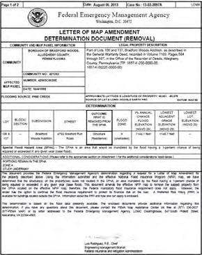
4 Letters of Map Amendment (LOMAs) LOMAs provide flood zone determinations for individual properties and structures Usually used to show a structure is out of the SFHA Not required by floodplain management regulations Based on natural ground elevations No physical change to the FIRM 4

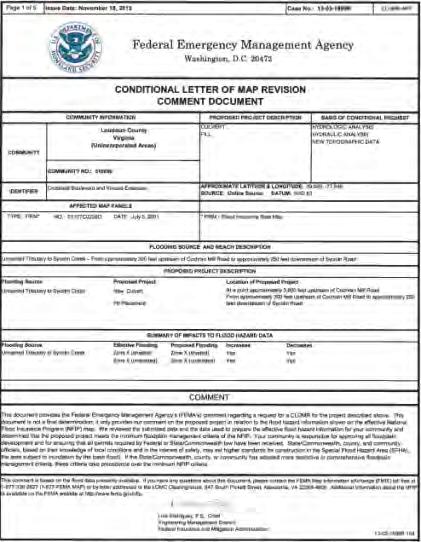
5 Conditional Letters of Map Revision Based on Fill (CLOMR-Fs) Proposed Structure CLOMR-Fs comment on whether a structure or parcel of land that will be elevated by fill will be located within the SFHA after the project is complete CLOMR-Fs do not remove a floodplain designation CLOMR-Fs do not waive floodplain development requirements An as-built LOMR-F must follow a CLOMR-F for an official change 5
 may be required by the local floodplain ordinance No physical change to the FIRM")
6 Letters of Map Revision Based on Fill (LOMR-Fs) LOMR-Fs provide official flood hazard determinations for individual structures and properties that have been elevated by fill Usually to show structure is elevated out of the SFHA Conditional LOMR-F (CLOMR-F) may be required by the local floodplain ordinance No physical change to the FIRM 6
7 Conditional Letters of Map Revision (CLOMRs) CLOMRs comment on the impact of a proposed project to floodplain boundaries, floodway boundaries, or BFEs Must be followed by as-built LOMRs NFIP regulations require a CLOMR when: Floodway encroachments increase the BFE Zone AE without floodway development will raise the BFE more than 1.0 feet Communities can pass the responsibility to obtain a CLOMR to the developer through the local floodplain ordinance 7


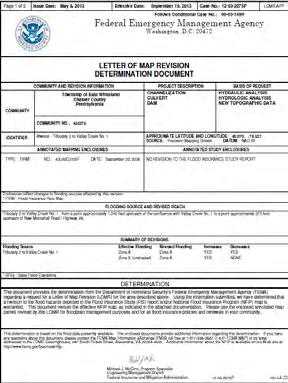
8 Letters of Map Revision (LOMRs) LOMRs physically update or refine the flood hazard information used to create the FIRM. Results in adjustment to the height of the BFE or boundaries of the SFHA Ensures that the FIRM is the most accurate reflection of the flood risk Requires engineering analyses and scientific data 8
9 When to Request a LOMC * Caution: Placement of fill around an existing foundation to increase the LAG could result in noncompliance To remove the mandatory flood insurance requirement Inadvertent inclusions structures built on natural high ground (LOMA) Structures elevated on fill* (LOMR-F) To update the map due to better topographic data, a physical change in the floodplain, or better modeling (LOMR) 9
10 Requirement to Submit New Data When is a community required to initiate a revision? Development occurring in Zones A1-30 and AE without a designated floodway for proposed increases of more than 1.0 foot Floodway encroachment (no-rise requirement) Alteration or relocation of a stream (including but not limited to installing culverts and bridges) Submission of new technical or scientific data The Coordinated Needs Management Strategy (CNMS) tracking tool is used by FEMA to track map update needs. Communities can share needs with FEMA using this tool. 10

11 LOMC Request Scenario One Property owner receives letter from bank requiring flood insurance for a home. Property owner must either provide proof of adequate flood insurance coverage or provide proof that the house is not in the high risk flood zone within 45 days. No fill has been placed on the property. 11
12 Scenario One Option and Considerations Options Request a LOMA if the house is on natural ground Considerations How many structures are on the property? Are the structures in the SFHA or is only part of the property in the SFHA? Is future development planned? 12

13 LOMC Request Scenario Two Property owner would like to build a house on a vacant parcel of land that is shown in an SFHA on the effective FIRM. Ground elevations at the project site are higher than the BFE because fill has been placed. 13
14 Scenario Two Options and Considerations Options Request a LOMR-F for the portion(s) of land above the BFE Request a CLOMR-F for the proposed structure Consideration If a CLOMR-F is requested for a structure, its proposed lowest floor should be above the BFE; Federal development requirements apply until the structure has been removed from the SFHA. 14

15 LOMC Request Scenario Three A developer would like to improve a large area of vacant land by building a subdivision within the SFHA. There are areas above and below the BFE on the site. The developer would like to ensure that the future residents will not be required to carry flood insurance and that if they chose to they could get a low risk premium. 15

16 Scenario Three Options and Considerations Options Submit a multiple structure CLOMA request for proposed structures with natural ground above the BFE; submit a multiple structure CLOMR-F request for proposed structures in lower lying areas. Obtain grading permit; add fill to lower lying areas and request a LOMR-F for all areas above the BFE, defined by metes and bounds. Considerations The developer and the Floodplain Administrator should discuss ways to design the subdivision so that the structures will be located on naturally high ground. 16

17 LOMC Request Scenario Four A community has permitted a major urban drainage project that has enlarged culverts, installed detention ponds, and has buried a section of a stream underground. The improvements have reduced obstructions to flows and the effective FIRM no longer reflects the actual flood risk. 17
18 Scenario Four Options and Considerations Option The community should request a LOMR to incorporate the changes into the effective FIRM. Consideration If improvements are made and a LOMR is not issued to update the flood hazard information, flood insurance rates and flood insurance requirements will continue to be determined based on the outdated, effective information. Further, LOMAs and LOMR- Fs can only be issued against the effective flood hazard information. 18

19 LOMC Request Scenario Five jpg A developer would like to build a shopping center in the regulatory floodway. The Floodplain Administrator believes the project will cause an increase in the BFE. The developer has stated that measures will be taken to avoid an increase in the BFE. 19
20 Scenario Five Options and Considerations Option Because there is a floodway present, the Floodplain Administrator must ask the developer to provide a no-rise certification from an engineer to prove that the development will not cause an increase in the BFE. or The Floodplain Administrator must request that the developer secure a CLOMR, as a condition of permitting the development. Consideration An as-built LOMR must be requested before the community s FIRM will reflect the post-project conditions. 20

21 LOMC Application Forms MT-EZ Single-lot or singlestructure residential LOMA requests MT-1 Multiple-lot or multiplestructure LOMA requests LOMA request for commercial properties CLOMAs and CLOMR-Fs LOMR-Fs MT-2 LOMRs and CLOMRs 21

22 Elevation Form Elevation Form MT-EZ /MT-1 Application Only includes information required to make a LOMC determination


23 Elevation Certificate Three main purposes Rate an insurance policy Demonstrate NFIP compliance Request a FIRM amendment May be submitted instead of the Elevation Form 23
 or Lowest Lot elevation(s) May be Required Certified metes and bounds description and map Other elevation data")
24 Documentation for a LOMA Required Recorded plat map or A recorded deed accompanied by tax assessor s map Usually Required Elevation Form with the certified Lowest Adjacent Grade (LAG) or Lowest Lot elevation(s) May be Required Certified metes and bounds description and map Other elevation data 24
25 Common Application Issues LOMAs Failure to write the legal property description and address on the application Failure to enter contact information and sign/date the application Submitting a deed or plat map that is not recorded Missing vertical datum on the Elevation Form Elevations not based on finished construction for an as-built determination 25


26 Documentation for a CLOMR-F Required Recorded plat map or A recorded deed accompanied by a tax assessor s map Community acknowledgment Processing fee Endangered Species Act (ESA) compliance No Effect Statement for ESA Compliance 26
27 Documentation for a LOMR-F Required Recorded plat map or A recorded deed accompanied by tax assessor s map Community acknowledgment Processing fee Similar to CLOMR-F requests, other data may also be required. 27
28 Documentation for a CLOMR Required Community concurrence and adoption Applicable forms within the MT-2 application Hydrologic and hydraulic data and modeling Topographic data Work maps Annotated FIRM panel(s) and FIS tables and/or profiles showing nature and extent of revised floodplain boundaries, floodway boundaries, and BFEs Public notice Processing fee ESA Compliance 28
29 Documentation for a LOMR Required Community concurrence Applicable forms within the MT-2 application Hydrologic and hydraulic data and modeling of completed development Topographic data Work maps Annotated FIRM panel(s) and FIS tables and/or profiles showing nature and extent of revised floodplain boundaries, floodway boundaries, and/or BFEs Public notice Processing fee If fill in floodway, no-rise analysis or CLOMR 29

30 Required Modeling for LOMRs and CLOMRs Effective Model Duplicate Effective Model Corrective Effective Model Existing Conditions Model Post-Project/Proposed Conditions Model 30
31 Common Application Issues LOMRs Vertical and horizontal tie-ins Missing Overview and Concurrence Form Misunderstanding of fee exemptions Individual Property Owner Notifications and Public Notice No Annotated FIRM and FIS pages Inconsistencies between mapping and modeling 31

32 Role of the Community - Amendment Community Acknowledgement Form Understand your role - you do not have to sign! Assist applicant with proposed development considerations Tracking and storing information LOMC determinations Elevation Data Permit and Inspection Data 32
33 Role of the Community Revisions Review CLOMR and LOMR applications Ensure revision is appropriate and in line with ordinance Make use of local resources, such as an engineer or legal counsel Require developers to request revisions through the local floodplain ordinance Make use of conditional process to ensure compliance before a project is complete Clearly communicate to developers their responsibility in the revision process Follow-up - ensure a LOMR is completed for final projects before C.O. 33

34 LOMCs: Basis of Determination For structures, the LAG must equal or exceed the regulatory flood elevation, to the nearest tenth of a foot. 34
35 Zone A LOMCs: Basis of Determination For Zone A areas which do not show BFEs on the FIRM/FIS, a 1% annual chance Water Surface Elevation (WSEL) must be determined to compare against the property information for a determination. For requests for which a flood elevation cannot be provided, one will be established by the LOMC reviewer using the best data available. In some cases, supporting data may be required before an elevation can be established by the reviewer. 35
36 LOMA/LOMR-F Outcomes Removal The subject of the determination has been removed the SFHA Non-Removal The subject of the determination remains in the SFHA Out as Shown The subject of the determination is not shown in the SFHA Other Response A determination cannot be made 36

37 LOMA Outcome 37

38 CLOMA Outcome 38
 and Flood Insurance Study (FIS) tables and/or profiles")
39 LOMR Outcomes Official Determination Document Accompanied by annotated FIRM panel(s) and Flood Insurance Study (FIS) tables and/or profiles 39
40 Fee Schedule LOMC Type Fee LOMR-F $425-$800 CLOMA $500-$700 CLOMR-F $500-$800 LOMR-F following CLOMR-F $325-$700 CLOMR (New Hydrology, Bridge, Culvert, Channel, or Combination Thereof) $4400 CLOMR (Levee, Berm, or Other Structural Measures) $6050 LOMR (New Hydrology, Bridge, Culvert, Channel, or Combination Thereof) $5300 LOMR (Levee, Berm, or Other Structural Measures) $7150 LOMR following CLOMR $5000 LOMR (Alluvial Fans) ***elomas and LOMAs are fee exempt*** $5600 initial fee Access the FEMA website for the most updated fee schedule: 40
41 LOMC Processing Timeframes LOMAs, LOMR-Fs, CLOMAs, and CLOMR-Fs are completed within 60 days of receiving all required data If additional data or a fee has been requested, the applicant has 90 days to submit the required data before the case is suspended Extensions may be granted LOMRs and CLOMRs are completed within 90 days of receiving all required data Issued LOMRs require a 4-6 month adoption period before becoming effective for legal use 41


42 Revalidation Letters LOMCs are only valid as long as the FIRM on which it was determined is still effective When a new FIRM is issued, all previously issued LOMCs are reviewed to determine whether the outcome has changed based on the new flood hazard area LOMRs are either superseded or incorporated into the new FIRM LOMAs and LOMR-Fs may be superseded, but those that are still valid are listed on a Revalidation Letter The Revalidation Letter is effective the day after the FIRM is effective Automatically initiated by FEMA as a map action

43 Online LOMC Allows a FIRM amendment or revision to be requested through an online platform instead of mailing in an application Supporting documentation can be uploaded online and case-related correspondence is ed to the applicant 43

44 eloma Online determination tool for simple LOMA requests Audits ensure accuracy Registration form available at: Registration form can be: ed to Faxed to (800) Mailed to: RAMPP eloma Coordinator Jonathon Foster, CFM 8401 Arlington Boulevard Fairfax, VA


45 eloma Eligibility Eligible for eloma Structure/lot on natural ground Single structure/lot Existing structure Zones A1-30 (except in floodway), AE (except in floodway), and AH New LOMA requests Subject area on FIRM panel has not been revised by a LOMR Structure/lot located on land that has not been annexed Not Eligible for eloma Structure/lot elevated by fill Multiple structures/lots; condominiums Proposed construction Zones A, V, VE, V1-V30, AO, D, B, C, X Re-issuances or LOMAs in progress Subject area on FIRM panel revised by LOMR Structure/lot located on annexed land 45
46 Resources FEMA Map Information exchange (FMIX) Toll free by phone at By at FEMA Map Service Center National Flood Hazard Layer FEMA GeoPortal eloma (Mapping Information Platform) Online LOMC Code of Federal Regulations LOMC Fee Information FEMA Forms NFIP Technical Bulletins USGS Vertical Datum Conversion Information 46
47 Contacts - FEMA Region III Floodplain Management and Insurance Branch Washington, D.C. Delaware Maryland Pennsylvania Virginia West Virginia Phetmano Phannavong, P.E., CFM Michael Powell, CFM David Guignet, P.E., CFM Daniel Fitzpatrick, CFM Charley Banks, CFM Kevin Sneed, CFM
48 Questions?
49 Upcoming Webinars: NFIP Essentials and Best Practices Series Building Codes and Floodplain Management Wednesday, May 7 th ; 10:00 11:30 am Substantial Improvement Tuesday, May 13 th ; 10:00 11:30 am Substantial Damage Wednesday, May 14 th ; 10:00 11:30 am Managing Zone A Floodplains Wednesday, May 28 th ; 10:00 11:30 am Reviewing & Interpreting Elevation Certificates Thursday, May 29 th ; 10:00 11:30 am 49
50
National Flood Insurance Program
 National Flood Insurance Program Base Flood Elevations in Zone A Streams Surveyor Training Presented by Thomas F. Smith, PE, PLS January 22, 2018 1 FEMA Region III Mitigation Division Floodplain Management
National Flood Insurance Program (NFIP) MT-1 Presentation. David Mummert, Michael Baker Jr., Inc.
 MT-1 Presentation. David Mummert, Michael Baker Jr., Inc.") National Flood Insurance Program (NFIP) MT-1 Presentation David Mummert, Michael Baker Jr., Inc. MT-1 Letters of Map Change (LOMCs) LOMC Review By FEMA FEMA required to notify the applicant in writing
National Flood Insurance Program (NFIP) MT-1 Presentation David Mummert, Michael Baker Jr., Inc. MT-1 Letters of Map Change (LOMCs) LOMC Review By FEMA FEMA required to notify the applicant in writing
MT 1, MT 2, Elevation Certificates & the Role of Surveyors
 MT 1, MT 2, Elevation Certificates & the Role of Surveyors Rocky Mountain Surveyors Summit March 3, 2016 Floods are acts of God, but flood losses are largely acts of man. - Dr. Gilbert White the father
Federal Emergency Management Agency
 Page 1 of 3 Date: July 21, 2016 Case No.: 16-05-5203A LOMA COMMUNITY AND MAP PANEL INFORMATION COMMUNITY KEWAUNEE COUNTY, WISCONSIN (Unincorporated Areas) Federal Emergency Management Agency Washington,
Criteria for Appeals of Flood Insurance Rate Maps. November 30, 201 1
 Criteria for Appeals of Flood Insurance Rate Maps November 30, 201 1 This document outlines the criteria for appealing proposed changes in flood hazard information on Flood Insurance Rate Maps (FIRMS)
Mingo County, WV Community Coordination Preliminary Flood Insurance Study and Flood Insurance Rate Map. Thursday, September 25, 2014
 Mingo County, WV Community Coordination Preliminary Flood Insurance Study and Flood Insurance Rate Map Thursday, September 25, 2014 Overview Preliminary Materials Preliminary FIS Report Digital Flood Insurance
2016 Fredericksburg Area Floodplain Management Workshop Tuesday, October 25, 2016
 2016 Fredericksburg Area Floodplain Management Workshop Tuesday, October 25, 2016 Charley Banks, CFM Department of Conservation And Recreation Division of Dam Safety & Floodplain Management Some Soapbox
HEC Software and FEMA Submittals
 HEC Software and FEMA Submittals EWRI Workshop HEC Users Conference Larry Voice Risk Analysis FEMA Region VI April 12, 2010 Overview Flood Hazard Analysis Overview of Map Changes Accepted Model List Guidance
FEDERAL EMERGENCY MANAGEMENT AGENCY MITIGATION DIRECTORATE TECHNICAL SERVICES DIVISION AMENDMENTS AND REVISIONS TO
 FEDERAL EMERGENCY MANAGEMENT AGENCY MITIGATION DIRECTORATE TECHNICAL SERVICES DIVISION AMENDMENTS AND REVISIONS TO NATIONAL FLOOD INSURANCE PROGRAM MAPS Application/Certification Forms and Instructions
CITY OF CAMBRIDGE FLOODPLAIN MANAGEMENT CHAPTER 7 (GRADING, EROSION AND SEDIMENT CONTROL)
") CITY OF CAMBRIDGE FLOODPLAIN MANAGEMENT CHAPTER 7 (GRADING, EROSION AND SEDIMENT CONTROL) City of Cambridge, MD Floodplain Management Ordinance (Tidal): May, 2011 1 City of Cambridge, Maryland Floodplain
CITY OF CAMBRIDGE FLOODPLAIN MANAGEMENT CHAPTER 7 (GRADING, EROSION AND SEDIMENT CONTROL) City of Cambridge, MD Floodplain Management Ordinance (Tidal): May, 2011 1 City of Cambridge, Maryland Floodplain
Chapter 5. Floodplain Management. 5.0 Introduction. 5.1 Floodplain Management and Regulation
 5.0 Introduction This chapter summarizes the Town s rules and regulations regarding floodplain management and development. The requirements presented in this chapter should be used by the design engineer
Oxford Floodplain Management Ordinance
 Table of Contents SECTION 1.0 GENERAL PROVISIONS...1 1.1 Findings...1 1.2 Statutory Authorization...1 1.3 Statement of Purpose...1 1.4 Areas to Which These Regulations Apply...2 1.5 Basis for Establishing
DIVISION 1. - GENERAL PROVISIONS
 Sec. 90-708. - Statutory authorization and purpose. Sec. 90-709. - Applicability. Sec. 90-710. - Compliance and liability. Sec. 90-711. - Records. Sec. 90-712. - Abrogation and greater restrictions. Sec.
Overview of Federal and State Floodplain Management Programs
 Overview of Federal and State Floodplain Management Programs Peter DeMeo, PE Supervising Environmental Engineer New Jersey Department of Environmental Protection Division of Land Use Regulation October
ORD-3309 BE IT ORDAINED BY THE CITY COUNCIL OF THE CITY OF VIRGINIA BEACH, VIRGINIA:
 ORD-3309 1 2 3 4 5 6 7 8 9 10 11 12 13 14 15 16 17 18 19 20 21 22 23 24 25 26 27 28 29 30 31 32 33 34 35 36 37 38 39 40 41 42 43 44 45 AN ORDINANCE TO ADOPT APPENDIX K, (FLOODPLAIN ORDINANCE) OF THE CITY
MAP INDEX CHECKLIST NOTES:
 REVIEWING YOUR PRELIMINARY DFIRM PANELS AND FIS REPORT A GUIDE FOR COMMUNITY OFFICIALS When a Georgia community is presented with new Digital Flood Insurance Rate Map (DFIRM) panels, the State of Georgia,
Map Modernization Modernization Program
 FEMA Map Modernization Program Presented to Maryland Association of Floodplain and Stormwater Managers October 27, 2005 Map Modernization Program Autorun.exe 2 Map Modernization Program Outline Map Mod
Letters of Map Amendment- Out as Shown
 Letters of Map Amendment- Out as Shown While digital Flood Insurance Rate Maps (DFIRM s) have made it easier to determine if a structure (or building site) is in the special flood hazard area (SFHA), many
Chapter 5. Floodplain Management. 5.0 Introduction. 5.1 Douglas County Comprehensive Master Plan. 5.2 Floodplain Management and Regulation
 5.0 Introduction This chapter summarizes the County s rules and regulations regarding floodplain management and development. The requirements presented in this chapter should be used by the design engineer
Floodplain Development Land Use Review
 PUBLIC WORKS - COMMUNITY DEVELOPMENT 333 Broadalbin Street SW, PO Box 490, Albany, Oregon 97321-0144 BUILDING 541-917-7553 PLANNING 541-917-7550 Floodplain Development Land Use Review Application Information
SECTION 10: FLOOD HAZARD EVALUATION 10-1
 10) SECTION 10: FLOOD HAZARD EVALUATION A. General. Land subject to being flooded by a Flood of 100-Year Frequency as defined by Title 76, Chapter 5, MCA, or land subject to flooding pursuant to these
Project Name: (Name as it appears in ESNAPS.) Spring Care Association
 Spring Care Association") Page 1 of 4 U.S. Department of Housing and Urban Development 451 Seventh Street, SW Washington, DC 20410 www.hud.gov espanol.hud.gov Environmental Review for Continuum of Care (CoC) Rental Assistance Project
Page 1 of 4 U.S. Department of Housing and Urban Development 451 Seventh Street, SW Washington, DC 20410 www.hud.gov espanol.hud.gov Environmental Review for Continuum of Care (CoC) Rental Assistance Project
RD:VMT:NGA ORD. NO /3/09 ORDINANCE NO
 ORDINANCE NO. 28512 AN ORDINANCE OF THE CITY OF SAN JOSE AMENDING CHAPTER 17.08 OF TITLE 17 OF THE SAN JOSE MUNICIPAL CODE TO UPDATE THE CITY S SPECIAL FLOOD HAZARD REGULATIONS WHEREAS, the Council of
What s New in FEMA Mapping?
 Discussion Topics What s New in FEMA Mapping? Eric Simmons September 6, 2018 FEMA Initiatives & Evolving Risk MAP FEMA s Flood Map Service Center National Flood Hazard Layer (NFHL) Draft NFHL and Changes
Date of Review: 11/6/2015 Reviewer: RCQ/LMC STATE
 FINAL Florida Review Checklist: NFIP & FBC & Revised Model Ordinance (January 15, 2013d) Ordinance Citation: Model FPM regulations and 5 th Edition FBC : All Zones Date of Review: 11/6/2015 Reviewer: RCQ/LMC
Final Report WI Flood Map Maintenance Project. Prepared For. The Wisconsin Department of Natural Resources Flood Map Maintenance Project
 Final Report WI Flood Map Maintenance Project Prepared For The Wisconsin Department of Natural Resources Flood Map Maintenance Project December 2007 TABLE OF CONTENTS INTRODUCTION 1 GIS DATA INVENTORY
ORDINANCE ARTICLE VI. RESOURCE PROTECTION STANDARDS
 ORDINANCE 2016-19 AN ORDINANCE OF THE CITY OF LAKE WALES, POLK COUNTY, FLORIDA AMENDING THE CITY OF LAKE WALES CODE OF ORDINANCES BY REPEALING CHAPTER 23 ZONING, LAND USE AND DEVELOPMENT REGULATIONS, ARTICLE
Chapter 8 FLOOD PREVENTION AND PROTECTION
 Chapter 8 FLOOD PREVENTION AND PROTECTION ARTICLE I - GENERAL 8.1 Title. 8.2 Scope. 8.3 Intent. 8.4 Coordination with the Florida Building Code. 8.5 Warning. 8.6 Disclaimer of Liability. 8.7 through 8.10
Cibola County Floodplain Development Permit Application
 Cibola County Floodplain Development Permit Application Application # FP Use Permit Variance Appeal Permit Fee $25.00 Date SECTION I: GENERAL PROVISIONS (APPLICANT to read and sign) 1. No work of any kind
FEMA POLICY: GUIDANCE ON THE USE OF AVAILABLE FLOOD HAZARD INFORMATION
 FEMA POLICY: GUIDANCE ON THE USE OF AVAILABLE FLOOD HAZARD INFORMATION FEMA Policy #104-008-2 BACKGROUND The policy is for FEMA Headquarters, Regional program staff, and for the Field Staff at the Joint
Appendix A Reproducible Forms
 Appendix A Reproducible Forms Form LD-33 LD-34 LD-35 LD-40 LD-41 LD-42 LD-50 LD-51 LD-52 LD-53 Subject County Engineer Approval Form Storm Sewer Computation Sheet Ohio Drainage Design Criteria Form Gutter
NOTICE
 www.ketteringoh.org NOTICE This City of Kettering Code section is not the official version and is provided only for the convenience of the public. The only official version of the City of Kettering Code
LDC AMENDMENT FLOODPLAINS
 Staff Report to the Municipal Planning Board March 20, 2018 L D C 2 0 1 8-10000 I T E M # 4 LDC AMENDMENT FLOODPLAINS Applicant City of Orlando Project Planner Elisabeth Dang, AICP Description of the Request:
FLOOD DAMAGE REDUCTION RESOLUTION GREENE COUNTY, OHIO
 FLOOD DAMAGE REDUCTION RESOLUTION GREENE COUNTY, OHIO SECTION 101.01: GENERAL PROVISIONS 101.01.1 Statutory Authorization This resolution is adopted pursuant to authorization contained in Sections 307.37
[Docket ID FEMA ; Internal Agency Docket No. FEMA-B-1406] AGENCY: Federal Emergency Management Agency, DHS.
![[Docket ID FEMA ; Internal Agency Docket No. FEMA-B-1406] AGENCY: Federal Emergency Management Agency, DHS.](/thumbs/95/124849871.jpg "[Docket ID FEMA ; Internal Agency Docket No. FEMA-B-1406] AGENCY: Federal Emergency Management Agency, DHS.") This document is scheduled to be published in the Federal Register on 04/22/2014 and available online at http://federalregister.gov/a/2014-09184, and on FDsys.gov 1 Billing Code 9110-12-P DEPARTMENT OF
This document is scheduled to be published in the Federal Register on 04/22/2014 and available online at http://federalregister.gov/a/2014-09184, and on FDsys.gov 1 Billing Code 9110-12-P DEPARTMENT OF
TOWN OF WILMINGTON FLOOD AND FLUVIAL EROSION HAZARD REGULATIONS
 Draft Wilmington Flood Hazard Regulation February 2019 TOWN OF WILMINGTON FLOOD AND FLUVIAL EROSION HAZARD REGULATIONS Contents 600. Statutory Authorization and Effect... 1 601. Statement of Purpose...
6. Help maintain a stable tax base by providing for the sound use and development of flood hazard areas;
 CHAPTER 9 FLOODPLAIN MANAGEMENT SECTION 101 GENERAL 101.1 Title. These regulations shall be known as the Floodplain Management Ordinance of Yankeetown, hereinafter referred to as this ordinance. 101.2
FEMA Map Modernization in Oklahoma
 FEMA Map in Oklahoma Oklahoma Floodplain Management Association Tulsa, Oklahoma Jerry Clark, P.E., RMC VI September 18, 2007 Introduction Accurate information about risks is the first step in preventing
City of Gilroy STAFF REPORT
 10.C City of Gilroy STAFF REPORT Agenda Item Title: Consideration of an Ordinance of the City Council of the City of Gilroy Repealing Ordinance No. 98-17 Entitled "Floodplain Management Ordinance" In It's
CHAPTER 1108 Flood Damage Protection
 CHAPTER 1108 Flood Damage Protection 1108.01 General Provisions. 1108.02 Definitions. 1108.03 Administration. 1108.04 Use and development standards for flood hazard reduction. 1108.05 Appeals and variances.
MASON COUNTY FLOODPLAIN ORDINANCE
 MASON COUNTY FLOODPLAIN ORDINANCE September 2013 AUTHORITY AND PURPOSE: AN ORDINANCE ESTABLISHING A FLOODPLAIN AREA AND REQUIRING ALL CONTRACTORS, PERSONS, PARTNERSHIPS, BUSINESSES, AND CORPORATIONS TO
TUSCARAWAS COUNTY FLOOD DAMAGE REDUCTION REGULATIONS
 TUSCARAWAS COUNTY FLOOD DAMAGE REDUCTION REGULATIONS 2010 Approved for adoption by ODNR 5/11/07 Adopted by the Board of Tuscarawas County Commissioners Date: October 1, 2007 Resolution No: 736-2007 Revised
WAYNE COUNTY, WV FLOODPLAIN ORDINANCE
 WAYNE COUNTY, WV FLOODPLAIN ORDINANCE AUTHORITY AND PURPOSE: AN ORDINANCE ESTABLISHING A FLOODPLAIN AREA AND REQUIRING ALL CONTRACTORS, PERSONS, PARTNERSHIPS, BUSINESSES, AND CORPORATIONS TO OBTAIN A PERMIT
Flood Hazard Development Permit Application & Permit Forms. For Communities with Coastal Velocity Zones [60.3(e)] CONTENTS
![Flood Hazard Development Permit Application & Permit Forms. For Communities with Coastal Velocity Zones [60.3(e)] CONTENTS](/thumbs/76/74346075.jpg "Flood Hazard Development Permit Application & Permit Forms. For Communities with Coastal Velocity Zones [60.3(e)] CONTENTS") Flood Hazard Development Permit Application & Permit Forms For Communities with Coastal Velocity Zones [60.3(e)] CONTENTS 1. Decision Tree 2. Flood Hazard Development Permit Application 3. Flood Hazard
Flood Hazard Development Permit Application & Permit Forms For Communities with Coastal Velocity Zones [60.3(e)] CONTENTS 1. Decision Tree 2. Flood Hazard Development Permit Application 3. Flood Hazard
ORDINANCE NO. 641-C BE IT ORDAINED BY THE CITY COUNCIL OF THE CITY OF SOUTHLAKE, TEXAS: ARTICLE I
 ORDINANCE NO. 641-C AN ORDINANCE PROVIDING FOR THE CITY OF SOUTHLAKE, TEXAS ADOPTING REGULATIONS DESIGNED TO MINIMIZE FLOOD LOSSES; ESTABLISHING PROVISIONS FOR FLOOD HAZARD REDUCTION; ADOPTING THE FLOOD
An Ordinance of the City of Shady Cove, Oregon An Oregon Municipal Corporation
 An Ordinance of the City of Shady Cove, Oregon An Oregon Municipal Corporation ORDINANCE NO. 259 Establishing Regulations To Prevent Flood Damage Within The City Of Shady Cove, Oregon, Adopting Related
CHAPTER 1313 Flood Damage Prevention Statutory authorization Exemption from filing a Findings
 11 CHAPTER 1313 Flood Damage Prevention 1313.01 Statutory authorization. 1313.02 Findings of fact. 1313.03 Statement of purpose. 1313.04 Methods of reducing flood losses. 1313.05 Lands to which these regulations
CITY OF AUSTELL DESIGN AND CONSTRUCTION STANDARDS LAND DEVELOPMENT ORDINANCES
 CITY OF AUSTELL DESIGN AND CONSTRUCTION STANDARDS LAND DEVELOPMENT ORDINANCES Land Development Ordinances Section 8 CITY OF AUSTELL DESIGN AND CONSTRUCTION STANDARDS LAND DEVELOPMENT ORDINANCES Article
KING WILLIAM COUNTY PLANNING COMMISSION AGENDA November 18, 2014 Regular Meeting 7:00PM
 KING WILLIAM COUNTY PLANNING COMMISSION AGENDA November 18, 2014 Regular Meeting 7:00PM 1. Call to Order 2. Roll Call 3. General Public Comment Period 4. Public Hearing ORD 14-02 Floodplain Management
LEE COUNTY ORDINANCE NO
 LEE COUNTY ORDINANCE NO. 15-09 AN ORDINANCE AMENDING LEE COUNTY LAND DEVELOPMENT CODE CHAPTERS 6 AND 10 AND CERTAIN SECTIONS OF THE FLORIDA BUILDING CODE TO AUTHORIZE THE BOARD OF ADJUSTMENTS AND APPEALS
SPECIAL PURPOSE FLOOD DAMAGE REDUCTION RESOLUTION FOR PICKAWAY COUNTY, OHIO
 SPECIAL PURPOSE FLOOD DAMAGE REDUCTION RESOLUTION FOR PICKAWAY COUNTY, OHIO Effective December 7, 2012 Pickaway County Board of Commissioners Glenn D. Reeser Jay H. Wippel Ula Jean Metzler Terry L. Frazier,
For public hearing by the Town Council and Planning Commission March 24, 2014
 AN ORDINANCE TO AMEND SECTION 17.0 FLOOD HAZARD OVERLAY DISTRICT FH OF THE ZONING ORDINANCE OF THE TOWN OF SCOTTSVILLE, VIRGINIA BE IT ORDAINED by the Town Council of the Town of Scottsville, Virginia,
CHAPTER 109 NATURAL RESOURCES AND ENVIRONMENTAL PROTECTION. ARTICLE I. Flood Damage Prevention In General
 Sec. 109-1. - Authorization. CHAPTER 109 NATURAL RESOURCES AND ENVIRONMENTAL PROTECTION ARTICLE I. Flood Damage Prevention In General Article IX, Section II of the Constitution of the State of Georgia
ORDINANCE NO. 14 C2-) AN ORDINANCE OF THE COUNTY OF VENTURA REPEALING AND REENACTING THE VENTURA COUNTY FLOODPLAIN MANAGEMENT ORDINANCE SECTION 1
 AN ORDINANCE OF THE COUNTY OF VENTURA REPEALING AND REENACTING THE VENTURA COUNTY FLOODPLAIN MANAGEMENT ORDINANCE SECTION 1") ORDINANCE NO. 14 C2-) AN ORDINANCE OF THE COUNTY OF VENTURA REPEALING AND REENACTING THE VENTURA COUNTY FLOODPLAIN MANAGEMENT ORDINANCE The Board of Supervisors of the County of Ventura ordains as follows:
ORDINANCE NO. 14 C2-) AN ORDINANCE OF THE COUNTY OF VENTURA REPEALING AND REENACTING THE VENTURA COUNTY FLOODPLAIN MANAGEMENT ORDINANCE The Board of Supervisors of the County of Ventura ordains as follows:
PARK COUNTY FLOODPLAIN HAZARD MANAGEMENT REGULATIONS Effective March 30, Adoption Date March 30, 2017
 PARK COUNTY FLOODPLAIN HAZARD MANAGEMENT REGULATIONS Effective March 30, 2017 Adoption Date March 30, 2017 1 March 2017 TABLE OF CONTENTS SECTION 1. TITLE, PURPOSE, AUTHORITY AND GENERAL PROVISIONS 1.1
ELEVATION CERTIFICATE
 ELEVATION CERTIFICATE IMPORTANT: In these spaces, copy the corresponding information from Section A. FOR INSURANCE COMPANY USE Building Street Address (including Apt., Unit, Suite, and/or Bldg. No.) or
1/23/2017. Floodplain Update For Surveyors. Floodplain Updates For Surveyors. Sample FEMA Map with SFHA
 Floodplain Updates For Surveyors Ceil Strauss MN State Floodplain Manager February 9, 2017 Floodplain Update For Surveyors Finding FEMA Maps & Data Map / Data Updates & Status Other useful resources Letters
FLOODPLAIN HAZARD MANAGEMENT REGULATIONS 2014 REGULATIONS COUNTY OF FALLON
 FLOODPLAIN HAZARD MANAGEMENT REGULATIONS 2014 REGULATIONS COUNTY OF FALLON & MONTANA DEPARTMENT OF NATURAL RESOURCES AND CONSERVATION WATER RESOURCES DIVISION 1424 9 TH Avenue P.O. Box 201601 Helena, Montana
AGENCY: Federal Emergency Management Agency, DHS. SUMMARY: Comments are requested on proposed flood hazard determinations, which
 This document is scheduled to be published in the Federal Register on 02/05/2013 and available online at http://federalregister.gov/a/2013-02455, and on FDsys.gov 1 Billing Code 9110-12-P DEPARTMENT OF
Chatham County Flood Damage Prevention Ordinance
 CHATHAM COUNTY FLOOD DAMAGE PREVENTION ORDINANCE ARTICLE 1 STATUTORY AUTHORIZATION, FINDINGS OF FACT, PURPOSE AND OBJECTIVES SECTION A STATUTORY AUTHORIZATION The Legislature of the State of North Carolina
STATUTORY AUTHORIZATION
 TABLE OF CONTENTS SECTION NUMBER NAME STARTS AT PAGE 16.1 Statutory Authorization, Findings of Fact, 16-1 Purpose and Objectives 16.2 Definitions 16-3 16.3 General Provisions 16-13 16.4 Administration
Chapter 8.01 FLOOD DAMAGE PREVENTION
 8.01.010 Chapter 8.01 FLOOD DAMAGE PREVENTION Sections: 8.01.010 Statutory authorization. 8.01.011 Findings of fact. 8.01.012 Statement of purpose. 8.01.013 Methods of reducing flood losses. 8.01.020 Definitions.
October 2011 Flood Insurance Manual
 FEMA NFIP C h a n g e s October 2011 Flood Insurance Manual 1 Significant Revisions The Changes Where to find the Change Building Occupancy Classification Updates Improvements and Betterments Coverage
FLOOD DAMAGE PREVENTION ORDINANCE FOR THE TOWN OF FRANKLIN
 FLOOD DAMAGE PREVENTION ORDINANCE FOR THE TOWN OF FRANKLIN ARTICLE 1. SECTION A. STATUTORY AUTHORIZATION, FINDINGS OF FACT, PURPOSE AND OBJECTIVES. STATUTORY AUTHORIZATION. The Legislature of the State
BEAVER COUNTY, PENNSYLVANIA
 VOLUME 3 OF 3 BEAVER COUNTY, PENNSYLVANIA (ALL JURISDICTIONS) Beaver County COMMUNITY NAME COMMUNITY NUMBER COMMUNITY NAME COMMUNITY NUMBER ALIQUIPPA, CITY OF 420101 AMBRIDGE, BOROUGH OF 420102 BADEN,
TOWN OF PINE LEVEL 2018 FLOOD DAMAGE PREVENTION ORDINANCE
 1 TOWN OF PINE LEVEL 2018 FLOOD DAMAGE PREVENTION ORDINANCE ARTICLE 1. SECTION A. STATUTORY AUTHORIZATION, FINDINGS OF FACT, PURPOSE AND OBJECTIVES. STATUTORY AUTHORIZATION. The Legislature of the State
City of Ferndale Floodplain Management Ordinance Page 1 of 18 ORDINANCE 08-02
 City of Ferndale Floodplain Management Ordinance 08-02 Page 1 of 18 ORDINANCE 08-02 AN ORDINANCE OF THE CITY COUNCIL OF THE CITY OF FERNDALE ESTABLISHING THE MINIMUM REQUIREMENTS OF THE NATIONAL FLOOD
City of Fort Atkinson
 City of Fort Atkinson FLOODPLAIN ZONING ORDINANCE With Flood Storage Modifications February 4, 2015 ADOPTED by Fort Atkinson City Council November 18, 2014 ORDINANCE NO. 725 The City Council of the City
ORDINANCE NO SECTION 1. RECITALS. The foregoing whereas clauses are incorporated herein by reference and made a part hereof.
 ORDINANCE NO. 13-10 AN ORDINANCE BY THE TREASURE ISLAND CITY COMMISSION AMENDING THE TREASURE ISLAND CODE OF ORDINANCES TO REPEAL CHAPTER 66, FLOOD CONTROL TO ADOPT A NEW CHAPTER 66, FLOODPLAIN MANAGEMENT
(Ord. No , 5(Exh. C), )
, )") Chapter 34 - FLOOD DAMAGE PREVENTION [1] Footnotes: --- (1) --- Editor's note The flood damage prevention ordinance, as set out herein by Ord. No. 20-09, 5(Exh. C), adopted Sept. 21, 2009, shall become
Chapter 34 - FLOOD DAMAGE PREVENTION [1] Footnotes: --- (1) --- Editor's note The flood damage prevention ordinance, as set out herein by Ord. No. 20-09, 5(Exh. C), adopted Sept. 21, 2009, shall become
[Docket ID FEMA ; Internal Agency Docket No. FEMA-B-1646] AGENCY: Federal Emergency Management Agency, DHS.
![[Docket ID FEMA ; Internal Agency Docket No. FEMA-B-1646] AGENCY: Federal Emergency Management Agency, DHS.](/thumbs/95/126279594.jpg "[Docket ID FEMA ; Internal Agency Docket No. FEMA-B-1646] AGENCY: Federal Emergency Management Agency, DHS.") This document is scheduled to be published in the Federal Register on 09/22/2016 and available online at https://federalregister.gov/d/2016-22787, and on FDsys.gov 1 Billing Code 9110-12-P DEPARTMENT OF
This document is scheduled to be published in the Federal Register on 09/22/2016 and available online at https://federalregister.gov/d/2016-22787, and on FDsys.gov 1 Billing Code 9110-12-P DEPARTMENT OF
MODEL FLOODPLAIN MANAGEMENT / FLOOD DAMAGE PREVENTION ORDINANCE
 MODEL FLOODPLAIN MANAGEMENT / FLOOD DAMAGE PREVENTION ORDINANCE Description: Floodplain management involves the designation of flood-prone areas and the managing of their uses. It is also aimed at minimizing
ORDINANCE NO. THE CITY COUNCIL OF THE CITY OF BISHOP, STATE OF CALIFORNIA DOES ORDAIN AS FOLLOWS:
 ORDINANCE NO. AN ORDINANCE OF THE CITY COUNCIL OF THE CITY OF BISHOP, STATE OF CALIFORNIA, REPEALING BISHOP MUNICIPAL CODE CHAPTER 15.20 ENTITLED FLOOD DAMAGE PREVENTION AND ORDINANCE NOS. 432 AND 450,
Chapter FLOOD DAMAGE PREVENTION
 Lake Elsinore Municipal Code Chapter 15.64 FLOOD DAMAGE PREVENTION Page 1 of 29 Sections: 15.64.100 Statutory authorization. 15.64.110 Findings of fact. 15.64.120 Statement of purpose. 15.64.130 Methods
[Docket ID FEMA ; Internal Agency Docket No. FEMA-B-1518] AGENCY: Federal Emergency Management Agency, DHS.
![[Docket ID FEMA ; Internal Agency Docket No. FEMA-B-1518] AGENCY: Federal Emergency Management Agency, DHS.](/thumbs/87/97204602.jpg "[Docket ID FEMA ; Internal Agency Docket No. FEMA-B-1518] AGENCY: Federal Emergency Management Agency, DHS.") This document is scheduled to be published in the Federal Register on 06/08/ and available online at http://federalregister.gov/a/-13857, and on FDsys.gov 1 9110-12-P DEPARTMENT OF HOMELAND SECURITY Federal
This document is scheduled to be published in the Federal Register on 06/08/ and available online at http://federalregister.gov/a/-13857, and on FDsys.gov 1 9110-12-P DEPARTMENT OF HOMELAND SECURITY Federal
ORDINANCE NO NOW, THEREFORE, BE IT ORDAINED by the Town Council of the Town of Indian
 ORDINANCE NO. 509 AN ORDINANCE BY THE TOWN OF INDIAN RIVER SHORES, FLORIDA AMENDING THE CODE OF ORDINANCES TO REPEAL CHAPTER 165 OF THE LAND DEVELOPMENT CODE; TO ADOPT A NEW CHAPTER 165 OF THE LAND DEVELOPMENT
COMMERCIAL SITE DEVELOPMENT GUIDE FOR UNINCORPORATED ST. CHARLES COUNTY
 COMMERCIAL SITE DEVELOPMENT GUIDE FOR UNINCORPORATED ST. CHARLES COUNTY GENERAL INFORMATION: This brochure is to be used as a guide and is not intended to amend or supersede the corresponding County ordinances
ORDINANCE NO. XX-16. WHEREAS, the City Commission of the City of Delray Beach adopts the findings in the Planning and Zoning Staff Report; and
 ORDINANCE NO. XX-16 AN ORDINANCE OF THE CITY COMMISSION OF THE CITY OF DELRAY BEACH, FLORIDA, AMENDING THE LAND DEVELOPMENT REGULATIONS OF THE CODE OF ORDINANCES, BY REPEALING SECTION 4.5.3, FLOOD DAMAGE
TOWNSHIP OF BORDENTOWN LAND DEVELOPMENT APPLICATION CHECKLIST. General Requirements for all Applications
 TOWNSHIP OF BORDENTOWN LAND DEVELOPMENT APPLICATION CHECKLIST This CHECKLIST has been adopted in accordance with Section 25:807 of the Land Development Ordinance of the Township of Bordentown and will
FLOOD DAMAGE PREVENTION
 ARTICLE 30 FLOOD DAMAGE PREVENTION 30.01 General Provisions... 30-1 30.02 Administration... 30-2 30.03 Provisions for Flood Hazard Reduction... 30-7 30.01 General Provisions 30.01.01 Lands to Which This
Purpose: Regulations:
 Administrative Procedures for the Designation and Refinement Of Chesapeake Bay Preservation Area Boundaries Guidance on the Chesapeake Bay Preservation Area Designation and Management Regulations September,
Map Modernization State Business Plan for Ohio January 2004 Attachment #2
 Map Modernization State Business Plan for Ohio January 2004 Attachment #2 FEDERAL EMERGENCY MANAGEMENT AGENCY COOPERATING TECHNICAL PARTNERS MEMORANDUM OF AGREEMENT AGREEMENT is made on April 22, 2003,
SUBDIVISION APPLICATION CHECKLIST SKETCH PLAN PRELIMINARY PLAT FINAL PLAT
 RECEIVED STAMP SUBDIVISION APPLICATION CHECKLIST SKETCH PLAN PRELIMINARY PLAT FINAL PLAT A checklist of background information and submission requirements for processing of a sketch plan, preliminary plat
NOTICE OF LAND USE DECISION BY THE COOS COUNTY PLANNING DIRECTOR
 NOTICE OF LAND USE DECISION BY THE COOS COUNTY PLANNING DIRECTOR Coos County Planning 225 N. Adams St. Coquille, OR 97423 http://www.co.coos.or.us/ Phone: 541-396-7770 Fax: 541-396-1022 This notice is
YOLO COUNTY ZONING CODE TITLE 8 LAND DEVELOPMENT CHAPTER 4: FLOOD PROTECTION. Article 1: Findings of Fact, Purpose and Methods
 YOLO COUNTY ZONING CODE TITLE 8 LAND DEVELOPMENT CHAPTER 4: FLOOD PROTECTION Article 1: Findings of Fact, Purpose and Methods Sec. 8-4.101 Statutory authorization The Legislature of the State of California
ALBEMARLE COUNTY CODE CHAPTER 18 ZONING SECTION 30 OVERLAY DISTRICTS
 CHAPTER 18 ZONING SECTION 30 OVERLAY DISTRICTS Sections: 30.1 OVERLAY DISTRICTS, GENERALLY 30.1.1 INTENT 30.1.2 APPLICATION 30.2 AIRPORT IMPACT AREA OVERLAY DISTRICT - AIA 30.2.1 INTENT 30.2.2 APPLICATION
Residential Major Subdivision Review Checklist
 Residential Major Subdivision Review Checklist Plan Submittal Requirements: 2 full sets of stamped plans Electric submittal - all plans contained in a single PDF 3 full sets if commercial kitchen or dining
[Docket ID FEMA ; Internal Agency Docket No. FEMA-B-1751] AGENCY: Federal Emergency Management Agency, DHS.
![[Docket ID FEMA ; Internal Agency Docket No. FEMA-B-1751] AGENCY: Federal Emergency Management Agency, DHS.](/thumbs/87/95259803.jpg "[Docket ID FEMA ; Internal Agency Docket No. FEMA-B-1751] AGENCY: Federal Emergency Management Agency, DHS.") This document is scheduled to be published in the Federal Register on 10/26/2017 and available online at https://federalregister.gov/d/2017-23228, and on FDsys.gov 1 Billing Code 9110-12-P DEPARTMENT OF
This document is scheduled to be published in the Federal Register on 10/26/2017 and available online at https://federalregister.gov/d/2017-23228, and on FDsys.gov 1 Billing Code 9110-12-P DEPARTMENT OF
DLCD ACKNOWLEDGMENT or DEADLINE TO APPEAL: Friday, April 22, 2011
 Department of Land Conservation and Development 635 Capitol Street, Suite 150 Salem, O R 9730 1-2540 (503) 373-0050 Fax (503) 378-5518 w w w. lc d. s tat e. or. us NOTICE OF ADOPTED AMENDMENT fita 04/11/2011
LUZERNE COUNTY ZONING ORDINANCE TEXT AMENDMENTS FLOOD PLAIN MANAGEMENT
 LUZERNE COUNTY ZONING ORDINANCE TEXT AMENDMENTS FLOOD PLAIN MANAGEMENT Eliminate in Article 11 DEFINITIONS The definitions of Flood, Flood- Fringe, Floodway, One Hundred Year Flood and One Hundred (100)
TOWN OF JEWETT LOCAL LAW # OF 2008 FLOOD PREVENTION LOCAL LAW STATUTORY AUTHORIZATION AND PURPOSE
 TOWN OF JEWETT LOCAL LAW # OF 2008 FLOOD PREVENTION LOCAL LAW SECTION 1. STATUTORY AUTHORIZATION AND PURPOSE 1.1 FINDINGS The Town Board of the Town Jewett finds that the potential and/or actual damages
On motion by, and seconded by, All Council Members present, the following ordinance was introduced: ORDINANCE 1552
 On motion by, and seconded by, All Council Members present, the following ordinance was introduced: ORDINANCE 1552 An ordinance repealing Chapter 10 BUILDING AND CONSTRUCTION REGULATIONS - Article II Special
Law # 1 of 2008 SECTION 1.0 STATUTORY AUTHORIZATION AND PURPOSE
 Law # 1 of 2008 A local law for Flood Damage Prevention as authorized by the New York State Constitution, Article IX, Section 2, and Environmental Conservation Law, Article 36 1.1 FINDINGS SECTION 1.0
DUPLIN COUNTY FLOOD DAMAGE PREVENTION ORDINANCE
 DUPLIN COUNTY FLOOD DAMAGE PREVENTION ORDINANCE Non-Coastal Regular Phase ARTICLE 1. SECTION A. STATUTORY AUTHORIZATION, FINDINGS OF FACT, PURPOSE AND OBJECTIVES. STATUTORY AUTHORIZATION. The Legislature
[Docket ID FEMA ; Internal Agency Docket No. FEMA-B-1756] AGENCY: Federal Emergency Management Agency, DHS.
![[Docket ID FEMA ; Internal Agency Docket No. FEMA-B-1756] AGENCY: Federal Emergency Management Agency, DHS.](/thumbs/89/97520517.jpg "[Docket ID FEMA ; Internal Agency Docket No. FEMA-B-1756] AGENCY: Federal Emergency Management Agency, DHS.") This document is scheduled to be published in the Federal Register on 10/26/2017 and available online at https://federalregister.gov/d/2017-23230, and on FDsys.gov 1 Billing Code 9110-12-P DEPARTMENT OF
This document is scheduled to be published in the Federal Register on 10/26/2017 and available online at https://federalregister.gov/d/2017-23230, and on FDsys.gov 1 Billing Code 9110-12-P DEPARTMENT OF
B. Minimize expenditure of public money for costly flood-control projects;
 CHAPTER 1100. SPECIAL DEVELOPMENT STANDARDS SECTION 1104. FLOOD DAMAGE PREVENTION 1104.1. Intent and Purpose The special flood hazard areas of the County are subject to periodic inundation, which may result
Article 18 FLOOD DAMAGE PREVENTION ORDINANCE (amended November 13, 2018)
") Article 18 FLOOD DAMAGE PREVENTION ORDINANCE (amended November 13, 2018) ARTICLE 18.1. SECTION A. STATUTORY AUTHORIZATION, FINDINGS OF FACT, PURPOSE AND OBJECTIVES. STATUTORY AUTHORIZATION. The Legislature
Article 18 FLOOD DAMAGE PREVENTION ORDINANCE (amended November 13, 2018) ARTICLE 18.1. SECTION A. STATUTORY AUTHORIZATION, FINDINGS OF FACT, PURPOSE AND OBJECTIVES. STATUTORY AUTHORIZATION. The Legislature
ORDINANCE NO. Section 1. That Berkeley Municipal Code Chapter is hereby repealed and reenacted to read as follows: Section 17.
 ORDINANCE NO. N.S. REPEALING AND REENACTING CHAPTER 17.12 OF THE BERKELEY MUNICIPAL CODE REGULATING FLOOD ZONE DEVELOPMENT, TO COMPLY WITH CURRENT NATIONAL FLOOD INSURANCE PROGRAM REQUIREMENTS BE IT ORDAINED
[Docket ID FEMA ; Internal Agency Docket No. FEMA-B-1808] AGENCY: Federal Emergency Management Agency, DHS.
![[Docket ID FEMA ; Internal Agency Docket No. FEMA-B-1808] AGENCY: Federal Emergency Management Agency, DHS.](/thumbs/82/86021413.jpg "[Docket ID FEMA ; Internal Agency Docket No. FEMA-B-1808] AGENCY: Federal Emergency Management Agency, DHS.") This document is scheduled to be published in the Federal Register on 03/16/2018 and available online at https://federalregister.gov/d/2018-05415, and on FDsys.gov 1 Billing Code 9110-12-P DEPARTMENT OF
This document is scheduled to be published in the Federal Register on 03/16/2018 and available online at https://federalregister.gov/d/2018-05415, and on FDsys.gov 1 Billing Code 9110-12-P DEPARTMENT OF
HARRISON COUNTY FLOOD DAMAGE PREVENTION ORDINANCE
 HARRISON COUNTY FLOOD DAMAGE PREVENTION ORDINANCE Harrison County Board Of Supervisors December 21, 2017 FLOOD DAMAGE PREVENTION TABLE OF CONTENTS ARTICLE 1. STATUTORY AUTHORIZATION, FINDINGS OF FACT,