MT 1, MT 2, Elevation Certificates & the Role of Surveyors
|
|
|
- Adam Harry Jones
- 6 years ago
- Views:
Transcription


1 MT 1, MT 2, Elevation Certificates & the Role of Surveyors Rocky Mountain Surveyors Summit March 3, 2016 Floods are acts of God, but flood losses are largely acts of man. - Dr. Gilbert White the father of floodplain management 2 another way to say it. Building in a floodplain is like pitching your tent on a highway when there are no cars coming. Dr. Vicki Miller, University of Montana 3 1

2 National Flood Insurance Program 4 Definitions & Acronyms FIRM - Flood Insurance Rate Map: The official map in which FEMA has delineated flood hazard areas applicable to the community. FIS Flood Insurance Study: The report that supports the FIRM. SFHA - Special Flood Hazard Area: The land within a community subject to a one-percent or greater chance of flooding in any given year. BFE - Base Flood Elevation: The water surface elevation of the flood having a one percent chance of being equaled or exceeded in any given year. LOMC - Letter of Map Change: An amendment or revision through the MT-1 or MT-2 process. LOMA LOMR-F LOMR CLOMR Conditional Letter of Map Revision: FEMA s comment on a proposed project. Does NOT revise the effective FIRM. 5 Definitions continued Basement: Any area of a building having its floor subgrade (below ground level) on all sides. Enclosure: Enclosed/walled areas below an elevated building used only for building access, vehicle parking, and/or storage that automatically equalizes hydrostatic pressure. Lowest Floor: The lowest floor of lowest enclosed area (including basement and crawl space). See Building Diagrams in the Elevation Certificate 6 2
3 Fill Fill: Defined as any material that is brought in, used or grading that as a result has elevated that existing conditions above the elevation of what it use to be. The common construction practice of removing unsuitable existing material (topsoil) and backfilling with select structural material is not considered the placement of fill if the practice does not alter the existing (natural grade) elevation. Fill that is placed before the date of the first NFIP map showing the area in a SFHA is considered natural grade. Check with the Community Status Book to determine when the community entered the NFIP. 7 Floodway Means the Channel of the Watercourse and the adjacent overbank land areas that must be reserved in order to discharge the Base Flood Elevation without cumulatively increasing the water surface elevations more than a designated amount. Sometimes referred to as the Regulatory Floodway. No development unless demonstrated through a hydrologic and hydraulic analysis that it causes a 0.00 rise. CLOMR You may be asked to survey pre & post project fill! 8 Floodway Schematic 100-YEAR FLOODPLAIN FLOODWAY FRINGE FLOODWAY SURCHARGE FLOODWAY + FLOODWAY FRINGES = FLOODPLAIN SURCHARGE NOT TO EXCEED 1.0 FOOT 0.5 on Colorado 9 3

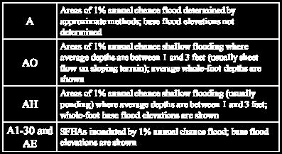
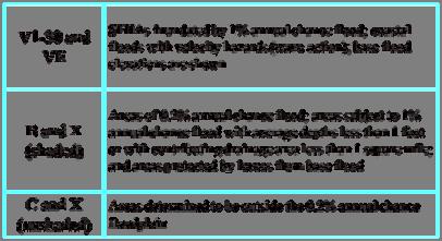


4 Flood Zone Designations 10 Flood Zone Designations 11 Flood Zone Designations 12 4
 25% of historic claims are outside the SFHA Do you have a policy? 13 Pre or Post FIRM http://www.fema.")

5 Flood Insurance Flood is not typically covered under standard homeowners policy. May be required by the property owner s lender if there is a federal backed loan. Rates usually equal the risk. Write Your Own (WYO) 25% of historic claims are outside the SFHA Do you have a policy? 13 Pre or Post FIRM 14 Floodplain Management FEMA does not regulate floodplains, this is a local responsibility! 44 CFR 60.3 New and Substantial Improvements must be built floodsafe Higher Standards Colorado Rules and Regulations for Floodplains Permit is required for all development in the SFHA 15 5

6 Development Any man made change to improved or unimproved real estate, including but not limited to buildings or other structres, mining, filling, grading, paving, excavation, drilling operations or storage of equipment or materials. 16 Flood Hazard Boundary Map: FHBM 17 Flood Insurance Rate Map: FIRM 18 6


7 Flood Insurance Study: FIS A Flood Insurance Study is a book that contains information regarding flooding in a community and is developed in conjunction with the FIRM and FHBM The FIS contains flood profiles, floodway data tables, summaries of elevations as well as a narrative of the flood history of a community and discusses the engineering methods used to develop the FIRMS 19 Floodway Data Table Presents the results of the floodway analysis at the cross sections shown on the FIRM or FHBM 20 Flood Profile 21 7


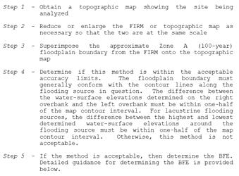
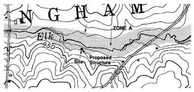
8 Determining a BFE When determining a BFE for a property or structure, the FIRM and Profile should be utilized. 22 Determining a BFE 23 Determining a BFE in a Zone A FEMA 265 Simplified Methods Contour Interpolation Data Extrapolation Detailed Methods Quick
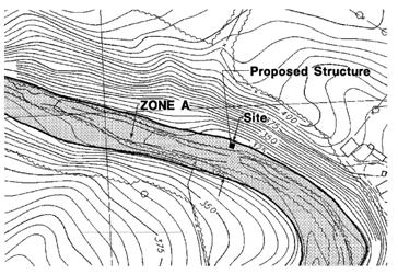
9 Contour Interpolation 25 Contour Interpolation 26 Contour Interpolation 27 9

10 Data Extrapolation 28 Data Extrapolation 29 Data Extrapolation 30 10


11 Map Service Center: Current Effective FIRM & FIS Preliminary Information Historic Information LOMCs GIS Databases FREE DOWNLOADS!! 31 Map Service Center Search by address 32 Map Service Center or search by product 33 11


12 Arvada Center 34 Arvada Center 35 Creating a FIRMette Don t forget to select page size!!! Select Scale and Title Block Move highlighted box to select area to include in FIRMette Choose format PDF or TIF 36 12


13 Finished FIRMette 37 FIRMette tutorial 38 Possible base map issues 39 13

14 National Flood Hazard Layer Interactive Community must have digital data Google Earth FEMA s Geoplatform 40 Geoplatform 41 Geoplatform Arvada Center 42 14


15 Geoplatform Arvada Center 43 Geoplatform Denver 44 Geoplatform Denver 45 15

16 Geoplatform Denver 46 Letters of Map Change: LOMC The boundaries for the SFHAs on the NFIP maps are prepared using the best topographic data available. Due to limitations of scale or topographic definition of the source map used to prepare a community s NFIP map, a property may be shown within the SFHA, but be on ground that is actually above the BFE for the site. As a result, the LOMC process was developed to amend or revise the published community maps by letter. FEMA has established several types of map changes. Changes that revise BFEs or published floodway information are Letters of Map Revision (LOMRs) and Physical Map Revisions (PMRs). Changes that do not revise BFEs include Letters of Map Amendments (LOMAs) and Letters of Map Revision Based on Fill (LOMR-Fs). In addition, FEMA provides comments on proposed projects, these conditional LOMCs do not amend or revise the effective NFIP maps. 47 LOMC Types Amendments: Structures or legally defined parcels Does not involve H&H analysis (Unless Zone A) Requires submittal of MT-1 Forms Does not involve changes in BFE Can not be used for properties in an Alluvial Fan Revisions: More complex map changes Not usually lot or structure specific Typically involves H&H analysis Requires submittal of MT-2 Forms MT-1 LOMA LOMR-F Conditional LOMR-FW (Floodway) MT-2 PMR LOMR Conditional 48 16
17 Amendments (MT 1) Letter of Map Amendment (LOMA) Request for exclusion of individual structure(s) and or legally defined parcel(s) of land that were inadvertently included in the SFHA Process outlined in Part 70 of NFIP Regulations Letter of Map Revision Based on Fill (LOMR-F) Request for exclusion of individual structure(s) and or legally defined parcel(s) of land that were elevated by earthen fill 49 Amendments (MT 1) Conditional Letter of Map Amendment (CLOMA) A letter from FEMA stating that a proposed structure that is not to be elevated by fill (natural grade) would not be inundated by the base flood if built as proposed. Process outlined in Part 70 of NFIP Regulations Conditional Letter of Map Revision Based on Fill (CLOMR-F) A letter from FEMA stating that a parcel of land or proposed structure that will be elevated by fill would not be inundated by the base flood if fill is placed on the parcel as proposed or the structure is built as proposed. Process outlined in Part 65 of NFIP Regulations 50 Conditional LOMA or LOMR F CLOMA or CLOMR-F: Does not amend the NFIP map NOT a building permit! Simply a comment document stating whether a structure/parcel of land will be safe from flooding if built as proposed Mostly the same data requirements as LOMA or LOMR-F request, but with proposed data CLOMR-F must show compliance with the Endangered Species Act 51 17
 Copy of the NFIP Map indicating")

18 Would this Structure likely be removed from the SFHA? Why? 52 Letter of of Map Map Amendment: LOMA LOMA 53 LOMA Data Requirements Completed MT-1 Property Information Form 1 (or MT-EZ) Copy of the NFIP Map indicating the subject property location FEMA Map Service Center view effective FIRM and create FIRMette Copy of recorded Deed or Plat map Copy of tax map showing property location Completed MT-1 Elevation Form or Elevation Certificate Metes & bounds description and map, if request is for portion of property BFE, and supporting data, if in unnumbered Zone A FEMA will determine if no BFE is provided but will be conservative


19 Legal Description of Deed Recorded Deed Can be based on recorded deed or recorded plat Must be from the County, not from a title company 55 Legal Description of Deed Legal Description from Deed Lot 16, Block 3 Kingsborough Subdivision Filing No. 6, as described in the Warranty Deed recorded as Reception No , in the Office of the Register of Clerk and Recorder, Arapahoe County, Colorado 56 Legal Description of a Plat 57 19
20 Requirements for Metes and Bounds Description of portion of property above 1% annual chance flood elevation and accompanying map (one must be certified by a professional surveyor or engineer) Certified elevation for lowest point within metes and bounds The metes and bounds description must match that of the map Descriptions are incorporated into legal description with phrase: the portion is more particularly described by the following metes and bounds The MT-EZ and the MT-1 instructions contain examples of the standard metes and bounds description 58 Metes and Bounds Metes and bounds map or description must be certified 59 Common Problems of Metes and Bounds Map and written description do not match Topographic map submitted shows portion of metes and bounds below BFE Metes and bounds are not certified No tie-in to Point of Beginning Starting and ending points do not come together May cause issues with lenders for insurance purposes Point of Commencing not displayed on the map Point of Commencing not a definable point 60 20


21 Metes and Bounds Determination 61 Tax Assessor s Map 62 Survey and/or Site Plan Required for most requests where property is located in floodway Must be certified Must include scale, North arrow, and vertical datum May be required for a submittal for an Out-As-Shown submittal 63 21
22 What about basements and crawlspaces? Any area of the building having its floor subgrade (below ground level) on all sides is considered a basement, unless it meets the definition of a crawlspace. The construction of a residential building in an identified SFHA with the lowest floor below the BFE is a violation of the floodplain management requirements set forth in CFR 60.3(c)(2) Basements below the BFE are only allowed in communities that have obtained a basement exception from FEMA. Floodproofed non-residential basements are allowed. 64 What about basements and crawlspaces? Technical Bulletin Building Diagram 9 and TB Per Technical Bulletin 11-01, some distinguishing features are: The interior grade of the crawlspace cannot be more than 2 feet below the LAG Shown as item D in the diagram on the left The difference between the crawlspace elevation and that of bottom of floor joist cannot exceed 4 feet Shown as item L on above diagram This limitation will prevent crawlspaces from being converted into habitable spaces The height limitation was determined using engineering analyses and building code requirements for flood hazard areas (page 7 of Technical Bulletin 11-01) Further restrictions apply and should be referenced to Technical Bulletin This pertains more to community compliance and documentation 66 22


23 Letter of Map Revision based on Fill: LOMR-F BFE 67 Letter of Map Revision Based on Fill Revision to the SFHA with no change to the BFE In areas with special flood hazard, it may be feasible to elevate areas with fill above the BFE 68 Criteria for a LOMR F If structure is involved: LAG and lowest floor 1 percent annual chance flood elevation Community must sign the Community Acknowledgement Form Fill must be engineered Compaction Erosion protection 69 23

24 LOMR F Data Requirements In addition to LOMA Data requirements, need: Completed MT-1 Form 4 (Community Acknowledgement Form) Appropriate Fee If applying for a CLOMR-F, need ESA documentation 70 MT 1 Review by FEMA FEMA is required to notify the applicant in writing within 60 days form the date of receipt of all data Requesters may check on status of all Letter of Map Change requests by contacting the FEMA Map Information exchange toll-free at 877-FEMA MAP ( ). 71 Determination Document Once you get a determination, make sure to read the entire document

25 Conditional Letter of Map Amendment: CLOMA Extremely Rare.. Probably better to submit traditional LOMA. 73 Conditional Letter of Map Revision based on Fill: CLOMR F FEMA s comment on a proposed project Does not change the map nor remove the requirement for flood insurance Must be followed up with a LOMR-F Compliance with the Endangered Species Act (ESA) 74 ESA Compliance ESA compliance must be documented to FEMA prior to the issuance of all CLOMR-Fs (required for all requests received on or after October 1, 2010). FEMA must receive confirmation of ESA compliance from the U.S. Fish & Wildlife Service (USFWS) or National Marine Fisheries Service (NMFS), collectively referred to as the Services. Once the required ESA documentation is received, the data will be sent to the FEMA Area E PAM for concurrence. Once concurrence is received from FEMA, processing of the case can resume. Acceptable documents demonstrating ESA compliance include the following: Incidental Take Permit Incidental Take Statement Not likely to adversely affect determination from the Services, or Documentation that the project has No Effect on listed species or critical habitat 75 25


26 Additional Data In certain instances, additional data that are not referenced on the MT 1 or MT EZ forms may be required Grading plans, building permits, cross sections, etc. 76 A special note about alluvial fans An alluvial fan is characterized by high-velocity flows; active processes of erosion, sediment transport, and deposition, and unpredictable flowpaths 77 Alluvial fan on a FIRM 78 26
27 Alluvial Fans and LOMCs FEMA issues LOMC upon determining properties/structures should not be included within a SFHA The procedures that result in the issuance of LOMCs are provided in Parts 65 and 70 of the NFIP regulations In areas subject to alluvial fan flooding, the provisions of these parts do not apply See Paragraph 65.13B of the NFIP regulations Letters of Map Amendments can not be issued for any property, structure or portion of property that are located within an Alluvial Fan 79 Online LOMC Can be used to request Amendments or Revisions. Online LOMC replaces the use of the MT 1, MT EZ or MT 2 paper forms. Although it speeds the time to submit an application, it does shorten the actual processing time. Unlike the eloma, anyone can utilize the online LOMC when submitting an application. 80 Why use the Online LOMC process? Submit, pay and upload all data through one online platform. Save information online and finish applying at your convenience. Manage multiple LOMC requests with one login. Check their application status in real time. Efficiently communicate with LOMC processing staff

28 eloma Determination Tool eloma is a MIP application designed to provide licensed land surveyors and professional engineers (Licensed Professionals or LPs) with a web-based system to submit and print simple LOMA requests 82 eloma Determination Tool The eloma tool is designed to allow users to receive a determination from FEMA in minutes, and the user can print a copy almost instantly 83 eloma Determination eloma will make a comparison of the submitted BFE with the submitted Lowest Adjacent Grade (LAG) or Low Lot Elevation (LLE) eloma will ensure that all required information has been entered Natural Ground 84 28

 Map Panel")
29 eloma Limitations Limitations Requests for existing single residential Structures or Legally Recorded Parcels of Land not involving the placement of fill Detail Studied Areas (AE, A1-A30, AH) No Approximate A Zones, V, AO, or D zones No Floodways No multi-lot requests or portions of properties Audit Procedures and Automatic Checks to Ensure Accuracy 85 Getting access to eloma Surveyor or Engineer must set up an account through Mapping Information Platform (MIP) using individual certification information to become an eloma LP The LP logs into the MIP to access eloma and has the option to: Create New Application Resume Previously Saved Application 86 eloma Data Requirements User Will Enter All Applicable data: Requestor Information Community Information (CID Number, etc ) Map Panel Information Latitude and Longitude Coordinates Elevation Information (LAG or LLE) Legal Property Description BFE (calculated using FIS text/profile) 87 29

30 The Audit Process The LP must submit supporting data to FEMA. If APPROVED, the LP will receive an notification that they can log-in and print the determination. If REJECTED, a LOMA will be completed by NSP and the LP will be audited again on their next submittal. After initial successful audit the LP will be able to generate determinations online. However, they will still be subject to random audits. 88 Common eloma audit mistakes Issues with the eloma Audits Supporting data from the LP is often incomplete Requests in unnumbered Zone A areas LPs not using the approved Legal Description format Previous LOMAs for the subject property 89 Audits Requiring Additional Data The Most Common Data Items Not Submitted Annotated FIS Flood Profile FIS Summary of Stillwater Elevations table Annotated copy of the effective FIRM panel Conversion factor for the vertical datum The Most Common Incomplete Data Items Unrecorded Plats or Deeds Flood Profiles or Summary of Stillwater Elevation tables that were not annotated Copies of the FIRM without the property location Elevation Forms or Certificates without the vertical datum 90 30


31 The Qualifying Questions ensure that the application meets the criteria for the eloma process. If the application does not meet the eloma criteria a notification appears that informs the LP that they need to submit their request using the standard LOMA (MT-1) process. 91 The LP enters their contact information. The address displayed is the address on file for the LP. If the address is incorrect the LP should contact MIP Help at miphelp@mapmodt eam.com and have their profile updated. 92 If the Subject is a structure the LP enters information about the construction type


32 The LP confirms the Lat/Long and Property information. 94 The LP enters the Community that the Subject is located in on the effective FIRM. They can either use the dropdowns or the CID free text field. The county and community choices are based on the State that the LP entered on the Property Description screen. 95 The LP selects the FIRM panel number that the Subject is located on and enters the elevation information for the Subject. The LP must indicate how they determined the BFE. For more information on how the BFE should be determined the LP can click the link in the BFE Method section or contact the FEMA Map Assistance Center at FEMA MAP ( ). The LP needs to make sure that the elevation datum used for the Subject elevations is the same as the elevation datum used on the effective FIRM

, C, and X (unshaded).")
 on the effective FIRM.")
33 The LP must answer the question about Subsidence or Uplift. If the LP is unsure about the answer to this question they can contact the Floodplain Administrator in the subject community for assistance. 97 The LP selects the Current and Resultant Flood Zones. The Resultant Flood Zone choices are based on the elevations entered by the LP on the FIRM Info screen. If the LP enters a BFE that is below the LAG or LLE, the Resultant Flood Zones choices will be B, X (shaded), C, and X (unshaded). The LP needs to make sure that the Resultant Zone they select appears on the effective FIRM. Subjects should not be removed to Zone C if the zone is labeled X (unshaded) on the effective FIRM. If the LP enters a BFE that is above the LAG or LLE, the Resultant Flood Zones choices will be AE, A1-A30, and AH. 98 To add a Flooding Source enter the name in the field and click the Add Flood Source button. The screen will refresh and the added Flooding Source will appear at the bottom of the screen. The LP may Modify or Delete the flooding source if they choose


34 The LP should review the information they entered and return to a specific screen using the Edit button to make corrections if necessary. 100 The LP must check the Penalty Clause box indicating that the information they provided in the application is accurate. At this point the LP should view the draft versions of the eloma Determination Letter and Cover Letter to ensure the information they entered appears properly on the documents. 101 If the LP sees this screen they must submit copies of their supporting data for the eloma Audit. The required documents are detailed in the automated audit notification that the LP receives but if they are unsure about what is required they can call the FEMA Map Assistance Center at FEMA MAP ( ) for help. The supporting data must be sent to the attention of the eloma Coordinator


35 If the LP sees this screen they must submit copies of their supporting data for the eloma Audit. The required documents are detailed in the automated audit notification that the LP receives but if they are unsure about what is required they can call the FEMA Map Assistance Center at FEMA MAP ( ) for help. The supporting data must be sent to the attention of the eloma Coordinator. 103 eloma vs. Online LOMC 104 MT 1 Fees (subject to change)

36 MT 1 Fees (subject to change) 106 MT 1 CAN NOT be processed if: Request involving changes in BFEs Request involving changes in regulatory floodway bound delineations Request These for will properties fall under in alluvial the fan MT-2 areas Request involving Process property and/or structures elevated by fill placed within the regulatory floodway, channelization projects, bridge/culvert replacement project, or other flood control improvements 107 Revisions (MT 2) Revisions that physically change the effective FIRM & FIS are either: Letter of Map Revision (LOMR) Physical Map Revision (PMR) Most will be processed as a LOMR but FEMA may upgrade to a PMR based on size of the revision. LOMRs are needed (and may be required) to incorporate changes from new development

37 Letter of Map Revision: LOMR LOMRs are needed for: Physical change is watercourse or floodplain boundaries due to development or natural forces. To incorporate better technical data into existing studies. To correct known study errors. To provide better hydrologic or hydraulic methodologies. 109 LOMR 110 Conditional Letter of Map Revision: CLOMR Proposed projects prior to any construction. Allows FEMA to comment on effects of project would have on FIRM & FIS. Does not revise the FIRM. Must be followed by a LOMR when project is complete. Not a permit
38 CLOMR Requirements At the request of the community Proposed project that: Encroaches upon the floodway and causes an increase > 0.00 Encroaches upon the floodplain when a floodway has not been established and cause an increase of >1.00 (0.5 in CO) What is an increase? Comparison between pre-project (existing conditions) and post project (proposed conditions) 112 MT 2 Application Required for all LOMRs & CLOMRs Completed MT-2 Application Forms Project Narrative Hydrologic and Hydraulic computation and digital model files Certified Topo Map with floodplain and floodway delineations Annotated FIRM showing changes due to the project Data certified by a registered processional engineer or licensed surveyor Revision request acknowled by all impacted communities. Notification of increases in BFE and/or SFHA as required by 44 CFR Fee Payment Current fee schedule: What is the Elevation Certificate (EC) Used For? The Elevation Certificate is an administrative tool of the National Flood Insurance Program (NFIP) and is to be used to provide elevation information necessary to: Ensure compliance with community floodplain management ordinances To determine the property insurance premium rate To support Letter of Map Change (LOMC) requests Use of this certificate does not provide a waiver of the flood insurance purchase requirement Only a LOMC can issue a determination document that removes the Federal mandate for a lending institution to require the purchase of flood insurance

39 Elevation Certificates are Not required by FEMA to demonstrate compliance unless the community participates in the Community Rating System 115 EC and Flood Insurance Required for buildings constructed: Post-FIRM Pre-FIRM but rated under Post-FIRM rules 116 New EC Form


40 Section A: Property Owner Information 118 Building Diagrams A7 119 Building Diagrams A


41 Building Diagrams A7 121 Building Diagrams A7 122 Building Diagrams A


42 Building Diagrams A7 124 Section B: FIRM Information 125 Information from FIRM

43 BFE From Flood Profile ELEVATION (FEET NGVD) SUTTER BLVD BRIDGE 500-YEAR FLOOD MONTEREY AVE BRIDGE 100-YEAR FLOOD 50-YEAR FLOOD 10-YEAR FLOOD STREAM BED 527 A B C D E STREAM DISTANCE IN FEET ABOVE CONFLUENCE WITH LAKE HIGHTOWER 127 Section C: Building Elevation Information All machinery and/or equipment such as furnaces, hot water heaters, heat pumps, a/c, and elevators, etc., installed and the grading around the building is completed. 128 Elevations by Building Type


44 Section D: Certification 130 Section E: Elevations Without Survey 131 Section F: Owner s Certification


45 Section G: Community Information 133 Which Diagram Do You Use? 134 Which Diagram Do You Use? Diagram

46 Which Diagram Do You Use? Enclosure 136 Which Diagram Do You Use? Diagram Which Diagram Do You Use?

47 Resources Local Floodplain Official State NFIP Coordinator Jamie Prochno CWCB tutorials 139 And now to Marsha for a local perspective.. Matthew Buddie matthew.buddie@fema.dhs.gov Tom Birney thomas.birney@fema.dhs.gov
National Flood Insurance Program (NFIP) MT-1 Presentation. David Mummert, Michael Baker Jr., Inc.
 MT-1 Presentation. David Mummert, Michael Baker Jr., Inc.") National Flood Insurance Program (NFIP) MT-1 Presentation David Mummert, Michael Baker Jr., Inc. MT-1 Letters of Map Change (LOMCs) LOMC Review By FEMA FEMA required to notify the applicant in writing
National Flood Insurance Program (NFIP) MT-1 Presentation David Mummert, Michael Baker Jr., Inc. MT-1 Letters of Map Change (LOMCs) LOMC Review By FEMA FEMA required to notify the applicant in writing
Letter of Map Change Fundamentals
 Letter of Map Change Fundamentals FEMA Region III National Flood Insurance Program Essentials and Best Practices Jana Green, CFM, RAMPP Topics of Discussion Why Apply for a Letter of Map Change (LOMC)?
Federal Emergency Management Agency
 Page 1 of 3 Date: July 21, 2016 Case No.: 16-05-5203A LOMA COMMUNITY AND MAP PANEL INFORMATION COMMUNITY KEWAUNEE COUNTY, WISCONSIN (Unincorporated Areas) Federal Emergency Management Agency Washington,
National Flood Insurance Program
 National Flood Insurance Program Base Flood Elevations in Zone A Streams Surveyor Training Presented by Thomas F. Smith, PE, PLS January 22, 2018 1 FEMA Region III Mitigation Division Floodplain Management
Criteria for Appeals of Flood Insurance Rate Maps. November 30, 201 1
 Criteria for Appeals of Flood Insurance Rate Maps November 30, 201 1 This document outlines the criteria for appealing proposed changes in flood hazard information on Flood Insurance Rate Maps (FIRMS)
Chapter 5. Floodplain Management. 5.0 Introduction. 5.1 Floodplain Management and Regulation
 5.0 Introduction This chapter summarizes the Town s rules and regulations regarding floodplain management and development. The requirements presented in this chapter should be used by the design engineer
Chapter 5. Floodplain Management. 5.0 Introduction. 5.1 Douglas County Comprehensive Master Plan. 5.2 Floodplain Management and Regulation
 5.0 Introduction This chapter summarizes the County s rules and regulations regarding floodplain management and development. The requirements presented in this chapter should be used by the design engineer
Map Modernization Modernization Program
 FEMA Map Modernization Program Presented to Maryland Association of Floodplain and Stormwater Managers October 27, 2005 Map Modernization Program Autorun.exe 2 Map Modernization Program Outline Map Mod
Letters of Map Amendment- Out as Shown
 Letters of Map Amendment- Out as Shown While digital Flood Insurance Rate Maps (DFIRM s) have made it easier to determine if a structure (or building site) is in the special flood hazard area (SFHA), many
2016 Fredericksburg Area Floodplain Management Workshop Tuesday, October 25, 2016
 2016 Fredericksburg Area Floodplain Management Workshop Tuesday, October 25, 2016 Charley Banks, CFM Department of Conservation And Recreation Division of Dam Safety & Floodplain Management Some Soapbox
FEDERAL EMERGENCY MANAGEMENT AGENCY MITIGATION DIRECTORATE TECHNICAL SERVICES DIVISION AMENDMENTS AND REVISIONS TO
 FEDERAL EMERGENCY MANAGEMENT AGENCY MITIGATION DIRECTORATE TECHNICAL SERVICES DIVISION AMENDMENTS AND REVISIONS TO NATIONAL FLOOD INSURANCE PROGRAM MAPS Application/Certification Forms and Instructions
Overview of Federal and State Floodplain Management Programs
 Overview of Federal and State Floodplain Management Programs Peter DeMeo, PE Supervising Environmental Engineer New Jersey Department of Environmental Protection Division of Land Use Regulation October
HEC Software and FEMA Submittals
 HEC Software and FEMA Submittals EWRI Workshop HEC Users Conference Larry Voice Risk Analysis FEMA Region VI April 12, 2010 Overview Flood Hazard Analysis Overview of Map Changes Accepted Model List Guidance
Floodplain Development Land Use Review
 PUBLIC WORKS - COMMUNITY DEVELOPMENT 333 Broadalbin Street SW, PO Box 490, Albany, Oregon 97321-0144 BUILDING 541-917-7553 PLANNING 541-917-7550 Floodplain Development Land Use Review Application Information
CITY OF CAMBRIDGE FLOODPLAIN MANAGEMENT CHAPTER 7 (GRADING, EROSION AND SEDIMENT CONTROL)
") CITY OF CAMBRIDGE FLOODPLAIN MANAGEMENT CHAPTER 7 (GRADING, EROSION AND SEDIMENT CONTROL) City of Cambridge, MD Floodplain Management Ordinance (Tidal): May, 2011 1 City of Cambridge, Maryland Floodplain
CITY OF CAMBRIDGE FLOODPLAIN MANAGEMENT CHAPTER 7 (GRADING, EROSION AND SEDIMENT CONTROL) City of Cambridge, MD Floodplain Management Ordinance (Tidal): May, 2011 1 City of Cambridge, Maryland Floodplain
Mingo County, WV Community Coordination Preliminary Flood Insurance Study and Flood Insurance Rate Map. Thursday, September 25, 2014
 Mingo County, WV Community Coordination Preliminary Flood Insurance Study and Flood Insurance Rate Map Thursday, September 25, 2014 Overview Preliminary Materials Preliminary FIS Report Digital Flood Insurance
RD:VMT:NGA ORD. NO /3/09 ORDINANCE NO
 ORDINANCE NO. 28512 AN ORDINANCE OF THE CITY OF SAN JOSE AMENDING CHAPTER 17.08 OF TITLE 17 OF THE SAN JOSE MUNICIPAL CODE TO UPDATE THE CITY S SPECIAL FLOOD HAZARD REGULATIONS WHEREAS, the Council of
An Ordinance of the City of Shady Cove, Oregon An Oregon Municipal Corporation
 An Ordinance of the City of Shady Cove, Oregon An Oregon Municipal Corporation ORDINANCE NO. 259 Establishing Regulations To Prevent Flood Damage Within The City Of Shady Cove, Oregon, Adopting Related
MODEL FLOODPLAIN MANAGEMENT / FLOOD DAMAGE PREVENTION ORDINANCE
 MODEL FLOODPLAIN MANAGEMENT / FLOOD DAMAGE PREVENTION ORDINANCE Description: Floodplain management involves the designation of flood-prone areas and the managing of their uses. It is also aimed at minimizing
Town of Alexandria. Floodplain Management Ordinance
 1 of 7 8/8/2009 4:56 PM Town of Alexandria Floodplain Management Ordinance SECTION 1 PURPOSE Certain areas of the Town of Alexandria, New Hampshire are subject to periodic flooding, causing serious damages
MAP INDEX CHECKLIST NOTES:
 REVIEWING YOUR PRELIMINARY DFIRM PANELS AND FIS REPORT A GUIDE FOR COMMUNITY OFFICIALS When a Georgia community is presented with new Digital Flood Insurance Rate Map (DFIRM) panels, the State of Georgia,
Oxford Floodplain Management Ordinance
 Table of Contents SECTION 1.0 GENERAL PROVISIONS...1 1.1 Findings...1 1.2 Statutory Authorization...1 1.3 Statement of Purpose...1 1.4 Areas to Which These Regulations Apply...2 1.5 Basis for Establishing
FEMA POLICY: GUIDANCE ON THE USE OF AVAILABLE FLOOD HAZARD INFORMATION
 FEMA POLICY: GUIDANCE ON THE USE OF AVAILABLE FLOOD HAZARD INFORMATION FEMA Policy #104-008-2 BACKGROUND The policy is for FEMA Headquarters, Regional program staff, and for the Field Staff at the Joint
CITY OF AUSTELL DESIGN AND CONSTRUCTION STANDARDS LAND DEVELOPMENT ORDINANCES
 CITY OF AUSTELL DESIGN AND CONSTRUCTION STANDARDS LAND DEVELOPMENT ORDINANCES Land Development Ordinances Section 8 CITY OF AUSTELL DESIGN AND CONSTRUCTION STANDARDS LAND DEVELOPMENT ORDINANCES Article
NOTICE
 www.ketteringoh.org NOTICE This City of Kettering Code section is not the official version and is provided only for the convenience of the public. The only official version of the City of Kettering Code
DIVISION 1. - GENERAL PROVISIONS
 Sec. 90-708. - Statutory authorization and purpose. Sec. 90-709. - Applicability. Sec. 90-710. - Compliance and liability. Sec. 90-711. - Records. Sec. 90-712. - Abrogation and greater restrictions. Sec.
ORDINANCE ARTICLE VI. RESOURCE PROTECTION STANDARDS
 ORDINANCE 2016-19 AN ORDINANCE OF THE CITY OF LAKE WALES, POLK COUNTY, FLORIDA AMENDING THE CITY OF LAKE WALES CODE OF ORDINANCES BY REPEALING CHAPTER 23 ZONING, LAND USE AND DEVELOPMENT REGULATIONS, ARTICLE
(Chapter Flood Damage Prevention)
") Chapter 13.10 Flood Damage Prevention Section: 13.10.010 Purpose and Policy 13.10.020 Definitions 13.10.030 Applicability and Areas of Special Flood Hazard 13.10.040 Administration 13.10.050 Provisions
Chapter 13.10 Flood Damage Prevention Section: 13.10.010 Purpose and Policy 13.10.020 Definitions 13.10.030 Applicability and Areas of Special Flood Hazard 13.10.040 Administration 13.10.050 Provisions
LDC AMENDMENT FLOODPLAINS
 Staff Report to the Municipal Planning Board March 20, 2018 L D C 2 0 1 8-10000 I T E M # 4 LDC AMENDMENT FLOODPLAINS Applicant City of Orlando Project Planner Elisabeth Dang, AICP Description of the Request:
6. Help maintain a stable tax base by providing for the sound use and development of flood hazard areas;
 CHAPTER 9 FLOODPLAIN MANAGEMENT SECTION 101 GENERAL 101.1 Title. These regulations shall be known as the Floodplain Management Ordinance of Yankeetown, hereinafter referred to as this ordinance. 101.2
Date of Review: 11/6/2015 Reviewer: RCQ/LMC STATE
 FINAL Florida Review Checklist: NFIP & FBC & Revised Model Ordinance (January 15, 2013d) Ordinance Citation: Model FPM regulations and 5 th Edition FBC : All Zones Date of Review: 11/6/2015 Reviewer: RCQ/LMC
Final Report WI Flood Map Maintenance Project. Prepared For. The Wisconsin Department of Natural Resources Flood Map Maintenance Project
 Final Report WI Flood Map Maintenance Project Prepared For The Wisconsin Department of Natural Resources Flood Map Maintenance Project December 2007 TABLE OF CONTENTS INTRODUCTION 1 GIS DATA INVENTORY
Chapter 8 FLOOD PREVENTION AND PROTECTION
 Chapter 8 FLOOD PREVENTION AND PROTECTION ARTICLE I - GENERAL 8.1 Title. 8.2 Scope. 8.3 Intent. 8.4 Coordination with the Florida Building Code. 8.5 Warning. 8.6 Disclaimer of Liability. 8.7 through 8.10
MASON COUNTY FLOODPLAIN ORDINANCE
 MASON COUNTY FLOODPLAIN ORDINANCE September 2013 AUTHORITY AND PURPOSE: AN ORDINANCE ESTABLISHING A FLOODPLAIN AREA AND REQUIRING ALL CONTRACTORS, PERSONS, PARTNERSHIPS, BUSINESSES, AND CORPORATIONS TO
FLOODPLAIN MANAGEMENT ORDINANCE
 FLOODPLAIN MANAGEMENT ORDINANCE ARTICLE I - PURPOSE AND ESTABLISHMENT Certain areas of the Town of North Berwick, Maine are subject to periodic flooding, causing serious damages to properties within these
ARTICLE 14 FLOODPLAIN MANAGEMENT
 ARTICLE 14 FLOODPLAIN MANAGEMENT 14.1 Purpose and Establishment Certain areas of the Town of Buxton, Maine are subject to periodic flooding, causing serious damages to properties within these areas. Relief
WAYNE COUNTY, WV FLOODPLAIN ORDINANCE
 WAYNE COUNTY, WV FLOODPLAIN ORDINANCE AUTHORITY AND PURPOSE: AN ORDINANCE ESTABLISHING A FLOODPLAIN AREA AND REQUIRING ALL CONTRACTORS, PERSONS, PARTNERSHIPS, BUSINESSES, AND CORPORATIONS TO OBTAIN A PERMIT
Chapter 8.01 FLOOD DAMAGE PREVENTION
 8.01.010 Chapter 8.01 FLOOD DAMAGE PREVENTION Sections: 8.01.010 Statutory authorization. 8.01.011 Findings of fact. 8.01.012 Statement of purpose. 8.01.013 Methods of reducing flood losses. 8.01.020 Definitions.
City of Ferndale Floodplain Management Ordinance Page 1 of 18 ORDINANCE 08-02
 City of Ferndale Floodplain Management Ordinance 08-02 Page 1 of 18 ORDINANCE 08-02 AN ORDINANCE OF THE CITY COUNCIL OF THE CITY OF FERNDALE ESTABLISHING THE MINIMUM REQUIREMENTS OF THE NATIONAL FLOOD
COMMERCIAL SITE DEVELOPMENT GUIDE FOR UNINCORPORATED ST. CHARLES COUNTY
 COMMERCIAL SITE DEVELOPMENT GUIDE FOR UNINCORPORATED ST. CHARLES COUNTY GENERAL INFORMATION: This brochure is to be used as a guide and is not intended to amend or supersede the corresponding County ordinances
ORD-3309 BE IT ORDAINED BY THE CITY COUNCIL OF THE CITY OF VIRGINIA BEACH, VIRGINIA:
 ORD-3309 1 2 3 4 5 6 7 8 9 10 11 12 13 14 15 16 17 18 19 20 21 22 23 24 25 26 27 28 29 30 31 32 33 34 35 36 37 38 39 40 41 42 43 44 45 AN ORDINANCE TO ADOPT APPENDIX K, (FLOODPLAIN ORDINANCE) OF THE CITY
ORDINANCE NO. THE CITY COUNCIL OF THE CITY OF BISHOP, STATE OF CALIFORNIA DOES ORDAIN AS FOLLOWS:
 ORDINANCE NO. AN ORDINANCE OF THE CITY COUNCIL OF THE CITY OF BISHOP, STATE OF CALIFORNIA, REPEALING BISHOP MUNICIPAL CODE CHAPTER 15.20 ENTITLED FLOOD DAMAGE PREVENTION AND ORDINANCE NOS. 432 AND 450,
Chapter FLOOD DAMAGE PREVENTION
 Lake Elsinore Municipal Code Chapter 15.64 FLOOD DAMAGE PREVENTION Page 1 of 29 Sections: 15.64.100 Statutory authorization. 15.64.110 Findings of fact. 15.64.120 Statement of purpose. 15.64.130 Methods
FLOOD HAZARD (FH) ZONING DISTRICT OR FLOOD HAZARD OVERLAY ZONE (Ord A, 10/20/2009) 1.0 INTRODUCTION
 ZONING DISTRICT OR FLOOD HAZARD OVERLAY ZONE (Ord A, 10/20/2009) 1.0 INTRODUCTION") Page 1 of 27 SECTION 29.4 FLOOD HAZARD (FH) ZONING DISTRICT OR FLOOD HAZARD OVERLAY ZONE (Ord. 315-776A, 10/20/2009) 1.0 INTRODUCTION 1.1 STATUTORY AUTHORIZATION: The Legislature of the State of California
Page 1 of 27 SECTION 29.4 FLOOD HAZARD (FH) ZONING DISTRICT OR FLOOD HAZARD OVERLAY ZONE (Ord. 315-776A, 10/20/2009) 1.0 INTRODUCTION 1.1 STATUTORY AUTHORIZATION: The Legislature of the State of California
Cibola County Floodplain Development Permit Application
 Cibola County Floodplain Development Permit Application Application # FP Use Permit Variance Appeal Permit Fee $25.00 Date SECTION I: GENERAL PROVISIONS (APPLICANT to read and sign) 1. No work of any kind
ORDINANCE NO. 641-C BE IT ORDAINED BY THE CITY COUNCIL OF THE CITY OF SOUTHLAKE, TEXAS: ARTICLE I
 ORDINANCE NO. 641-C AN ORDINANCE PROVIDING FOR THE CITY OF SOUTHLAKE, TEXAS ADOPTING REGULATIONS DESIGNED TO MINIMIZE FLOOD LOSSES; ESTABLISHING PROVISIONS FOR FLOOD HAZARD REDUCTION; ADOPTING THE FLOOD
Chatham County Flood Damage Prevention Ordinance
 CHATHAM COUNTY FLOOD DAMAGE PREVENTION ORDINANCE ARTICLE 1 STATUTORY AUTHORIZATION, FINDINGS OF FACT, PURPOSE AND OBJECTIVES SECTION A STATUTORY AUTHORIZATION The Legislature of the State of North Carolina
The Board of Supervisors of the County of Riverside ordains as follows:
 ORDINANCE NO. 458 (AS AMENDED THROUGH 458.13) AN ORDINANCE OF THE COUNTY OF RIVERSIDE AMENDING ORDINANCE NO. 458 REGULATING FLOOD HAZARD AREAS AND IMPLEMENTING THE NATIONAL FLOOD INSURANCE PROGRAM The
Flood Hazard Zone. [Amended effective ; ; ; ; ; ]
![Flood Hazard Zone. [Amended effective ; ; ; ; ; ]](/thumbs/82/86423647.jpg "Flood Hazard Zone. [Amended effective ; ; ; ; ; ]") ARTICLE 110, Flood Hazard Zone [Added effective 4-24-1978] 118-1100. Flood Hazard Zone. [Amended effective 8-19-1986; 2-26-1993; 6-18-2010; 12-24- 2010; 7-8-2013; 7-25-2014] A. Purpose and intent. (1)
ARTICLE 110, Flood Hazard Zone [Added effective 4-24-1978] 118-1100. Flood Hazard Zone. [Amended effective 8-19-1986; 2-26-1993; 6-18-2010; 12-24- 2010; 7-8-2013; 7-25-2014] A. Purpose and intent. (1)
TOWN OF JEWETT LOCAL LAW # OF 2008 FLOOD PREVENTION LOCAL LAW STATUTORY AUTHORIZATION AND PURPOSE
 TOWN OF JEWETT LOCAL LAW # OF 2008 FLOOD PREVENTION LOCAL LAW SECTION 1. STATUTORY AUTHORIZATION AND PURPOSE 1.1 FINDINGS The Town Board of the Town Jewett finds that the potential and/or actual damages
Law # 1 of 2008 SECTION 1.0 STATUTORY AUTHORIZATION AND PURPOSE
 Law # 1 of 2008 A local law for Flood Damage Prevention as authorized by the New York State Constitution, Article IX, Section 2, and Environmental Conservation Law, Article 36 1.1 FINDINGS SECTION 1.0
ELEVATION CERTIFICATE
 ELEVATION CERTIFICATE IMPORTANT: In these spaces, copy the corresponding information from Section A. FOR INSURANCE COMPANY USE Building Street Address (including Apt., Unit, Suite, and/or Bldg. No.) or
Section Floodplain Development Ordinance This ordinance, adopted pursuant to the authority of RSA 674:16, shall be known as the Town of Newport
 Section 212 - Floodplain Development Ordinance This ordinance, adopted pursuant to the authority of RSA 674:16, shall be known as the Town of Newport Floodplain Development Ordinance. The regulations and
City of Gilroy STAFF REPORT
 10.C City of Gilroy STAFF REPORT Agenda Item Title: Consideration of an Ordinance of the City Council of the City of Gilroy Repealing Ordinance No. 98-17 Entitled "Floodplain Management Ordinance" In It's
October 2011 Flood Insurance Manual
 FEMA NFIP C h a n g e s October 2011 Flood Insurance Manual 1 Significant Revisions The Changes Where to find the Change Building Occupancy Classification Updates Improvements and Betterments Coverage
TOWN OF SPAFFORD LOCAL LAW 3 OF THE YEAR 2016
 TOWN OF SPAFFORD LOCAL LAW 3 OF THE YEAR 2016 A Local Law Amending Local Law No. 2 of the Year 1990 to repeal the existing language and replace it with the following language relating to Flood Damage Prevention
LEE COUNTY ORDINANCE NO
 LEE COUNTY ORDINANCE NO. 15-09 AN ORDINANCE AMENDING LEE COUNTY LAND DEVELOPMENT CODE CHAPTERS 6 AND 10 AND CERTAIN SECTIONS OF THE FLORIDA BUILDING CODE TO AUTHORIZE THE BOARD OF ADJUSTMENTS AND APPEALS
1/23/2017. Floodplain Update For Surveyors. Floodplain Updates For Surveyors. Sample FEMA Map with SFHA
 Floodplain Updates For Surveyors Ceil Strauss MN State Floodplain Manager February 9, 2017 Floodplain Update For Surveyors Finding FEMA Maps & Data Map / Data Updates & Status Other useful resources Letters
TUSCARAWAS COUNTY FLOOD DAMAGE REDUCTION REGULATIONS
 TUSCARAWAS COUNTY FLOOD DAMAGE REDUCTION REGULATIONS 2010 Approved for adoption by ODNR 5/11/07 Adopted by the Board of Tuscarawas County Commissioners Date: October 1, 2007 Resolution No: 736-2007 Revised
NOTICE OF LAND USE DECISION BY THE COOS COUNTY PLANNING DIRECTOR
 NOTICE OF LAND USE DECISION BY THE COOS COUNTY PLANNING DIRECTOR Coos County Planning 225 N. Adams St. Coquille, OR 97423 http://www.co.coos.or.us/ Phone: 541-396-7770 Fax: 541-396-1022 This notice is
What s New in FEMA Mapping?
 Discussion Topics What s New in FEMA Mapping? Eric Simmons September 6, 2018 FEMA Initiatives & Evolving Risk MAP FEMA s Flood Map Service Center National Flood Hazard Layer (NFHL) Draft NFHL and Changes
FLOODPLAIN MANAGEMENT ORDINANCE
 FLOODPLAIN MANAGEMENT ORDINANCE FOR THE TOWN OF MARIAVILLE, MAINE Enacted April 4. 1997 STATEMENT OF PURPOSE AND INTENT Certain areas of the Town of Mariaville, Maine are subject to periodic flooding.
FLOODPLAIN MANAGEMENT ORDINANCE CONTENTS
 FLOODPLAIN MANAGEMENT ORDINANCE CONTENTS ARTICLE PAGE I. PURPOSE AND ESTABLISHMENT... 2 II. PERMIT REQUIRED... 2 III. APPLICATION FOR PERMIT... 2 IV. APPLICATION FEE AND EXPERT'S FEE... 4 V. REVIEW STANDARDS
CHAPTER 109 NATURAL RESOURCES AND ENVIRONMENTAL PROTECTION. ARTICLE I. Flood Damage Prevention In General
 Sec. 109-1. - Authorization. CHAPTER 109 NATURAL RESOURCES AND ENVIRONMENTAL PROTECTION ARTICLE I. Flood Damage Prevention In General Article IX, Section II of the Constitution of the State of Georgia
ORDINANCE NO. 14 C2-) AN ORDINANCE OF THE COUNTY OF VENTURA REPEALING AND REENACTING THE VENTURA COUNTY FLOODPLAIN MANAGEMENT ORDINANCE SECTION 1
 AN ORDINANCE OF THE COUNTY OF VENTURA REPEALING AND REENACTING THE VENTURA COUNTY FLOODPLAIN MANAGEMENT ORDINANCE SECTION 1") ORDINANCE NO. 14 C2-) AN ORDINANCE OF THE COUNTY OF VENTURA REPEALING AND REENACTING THE VENTURA COUNTY FLOODPLAIN MANAGEMENT ORDINANCE The Board of Supervisors of the County of Ventura ordains as follows:
ORDINANCE NO. 14 C2-) AN ORDINANCE OF THE COUNTY OF VENTURA REPEALING AND REENACTING THE VENTURA COUNTY FLOODPLAIN MANAGEMENT ORDINANCE The Board of Supervisors of the County of Ventura ordains as follows:
Project Name: (Name as it appears in ESNAPS.) Spring Care Association
 Spring Care Association") Page 1 of 4 U.S. Department of Housing and Urban Development 451 Seventh Street, SW Washington, DC 20410 www.hud.gov espanol.hud.gov Environmental Review for Continuum of Care (CoC) Rental Assistance Project
Page 1 of 4 U.S. Department of Housing and Urban Development 451 Seventh Street, SW Washington, DC 20410 www.hud.gov espanol.hud.gov Environmental Review for Continuum of Care (CoC) Rental Assistance Project
ARTICLE 18 TABLE OF CONTENTS TO THE FLOODPLAIN MANAGEMENT REGULATIONS
 Table of Contents Valley Center Floodplain Ordinance ARTICLE 18 TABLE OF CONTENTS TO THE FLOODPLAIN MANAGEMENT REGULATIONS Chapter 18.01 STATUTORY AUTHORIZATION, FINDINGS OF FACT & PURPOSES...1 18.01.01
PARK COUNTY FLOODPLAIN HAZARD MANAGEMENT REGULATIONS Effective March 30, Adoption Date March 30, 2017
 PARK COUNTY FLOODPLAIN HAZARD MANAGEMENT REGULATIONS Effective March 30, 2017 Adoption Date March 30, 2017 1 March 2017 TABLE OF CONTENTS SECTION 1. TITLE, PURPOSE, AUTHORITY AND GENERAL PROVISIONS 1.1
JACKSON COUNTY DEVELOPMENT RULES, REGULATIONS AND PROTOCOLS Non-Commercial Structures
 JACKSON COUNTY DEVELOPMENT RULES, REGULATIONS AND PROTOCOLS Non-Commercial Structures Mission Statement: We are first a public agency, funded by public tax dollars. Our fundamental mission is to protect
Flood Hazard Development Permit Application & Permit Forms. For Communities with Coastal Velocity Zones [60.3(e)] CONTENTS
![Flood Hazard Development Permit Application & Permit Forms. For Communities with Coastal Velocity Zones [60.3(e)] CONTENTS](/thumbs/76/74346075.jpg "Flood Hazard Development Permit Application & Permit Forms. For Communities with Coastal Velocity Zones [60.3(e)] CONTENTS") Flood Hazard Development Permit Application & Permit Forms For Communities with Coastal Velocity Zones [60.3(e)] CONTENTS 1. Decision Tree 2. Flood Hazard Development Permit Application 3. Flood Hazard
Flood Hazard Development Permit Application & Permit Forms For Communities with Coastal Velocity Zones [60.3(e)] CONTENTS 1. Decision Tree 2. Flood Hazard Development Permit Application 3. Flood Hazard
ORDINANCE # ARTICLE I STATUTORY AUTHORIZATION, FINDINGS OF FACT, PURPOSE AND METHODS
 60.3 (b) FLOOD DAMAGE PREVENTION ORDINANCE ORDINANCE #2009-07 ARTICLE I STATUTORY AUTHORIZATION, FINDINGS OF FACT, PURPOSE AND METHODS SECTION A. STATUTORY AUTHORIZATION The Legislature of the State of
STATUTORY AUTHORIZATION
 TABLE OF CONTENTS SECTION NUMBER NAME STARTS AT PAGE 16.1 Statutory Authorization, Findings of Fact, 16-1 Purpose and Objectives 16.2 Definitions 16-3 16.3 General Provisions 16-13 16.4 Administration
CHAPTER 16. ZONING AND PLANNING
 CHAPTER 16. ZONING AND PLANNING Article 1. Zoning Regulations Article 2. Floodplain Management Article 3. Subdivision Regulations Article 4. Comprehensive Land Use Plan ARTICLE 1. ZONING REGULATIONS 16-101.
FLOOD DAMAGE PREVENTION ORDINANCE FOR THE TOWN OF FRANKLIN
 FLOOD DAMAGE PREVENTION ORDINANCE FOR THE TOWN OF FRANKLIN ARTICLE 1. SECTION A. STATUTORY AUTHORIZATION, FINDINGS OF FACT, PURPOSE AND OBJECTIVES. STATUTORY AUTHORIZATION. The Legislature of the State
FLOOD DAMAGE REDUCTION RESOLUTION GREENE COUNTY, OHIO
 FLOOD DAMAGE REDUCTION RESOLUTION GREENE COUNTY, OHIO SECTION 101.01: GENERAL PROVISIONS 101.01.1 Statutory Authorization This resolution is adopted pursuant to authorization contained in Sections 307.37
ORDINANCE NO. Section 1. That Berkeley Municipal Code Chapter is hereby repealed and reenacted to read as follows: Section 17.
 ORDINANCE NO. N.S. REPEALING AND REENACTING CHAPTER 17.12 OF THE BERKELEY MUNICIPAL CODE REGULATING FLOOD ZONE DEVELOPMENT, TO COMPLY WITH CURRENT NATIONAL FLOOD INSURANCE PROGRAM REQUIREMENTS BE IT ORDAINED
Watershed Planning Regulations Oklahoma Municipal City of Tulsa. Urban; Suburban City of Tulsa Watershed Development Regulations. Abstract.
 Topic: Resource Type: State: Jurisdiction Type: Municipality: Year (adopted, written, etc.): 1989 Community Type applicable to: Title: Watershed Planning Regulations Oklahoma Municipal City of Tulsa Document
For public hearing by the Town Council and Planning Commission March 24, 2014
 AN ORDINANCE TO AMEND SECTION 17.0 FLOOD HAZARD OVERLAY DISTRICT FH OF THE ZONING ORDINANCE OF THE TOWN OF SCOTTSVILLE, VIRGINIA BE IT ORDAINED by the Town Council of the Town of Scottsville, Virginia,
Flood Damage Prevention
 Flood Damage Prevention Town of Berkshire Local Law No. 1 of the year 1989 A local law for flood damage prevention as authorized by the New York State Constitution, Article IX, Section 2, and Environmental
A. To prevent unwise development from increasing flood or drainage hazards to others.
 BOONE COUNTY FLOOD HAZARD AREA Ordinance No. 94 14 (September 19, 1994) Amended Ordinance No. 98 2 (April 6, 1998) Amended Ordinance No. 02 6 (June 3, 2002) SECTION 1 STATUTORY AUTHORIZATION The Indiana
Title 15. Buildings, Construction, Addressing and Land Use
 Chapters: 15.05 Land Use Fees 15.10 Flood Damage Prevention 15.15 Building Numbering Title 15 Buildings, Construction, Addressing and Land Use 15-1 Lyons Municipal Code 15.05.040 Chapter 15.05 Land Use
CHAPTER 1108 Flood Damage Protection
 CHAPTER 1108 Flood Damage Protection 1108.01 General Provisions. 1108.02 Definitions. 1108.03 Administration. 1108.04 Use and development standards for flood hazard reduction. 1108.05 Appeals and variances.
TOWN OF PINE LEVEL 2018 FLOOD DAMAGE PREVENTION ORDINANCE
 1 TOWN OF PINE LEVEL 2018 FLOOD DAMAGE PREVENTION ORDINANCE ARTICLE 1. SECTION A. STATUTORY AUTHORIZATION, FINDINGS OF FACT, PURPOSE AND OBJECTIVES. STATUTORY AUTHORIZATION. The Legislature of the State
YOLO COUNTY ZONING CODE TITLE 8 LAND DEVELOPMENT CHAPTER 4: FLOOD PROTECTION. Article 1: Findings of Fact, Purpose and Methods
 YOLO COUNTY ZONING CODE TITLE 8 LAND DEVELOPMENT CHAPTER 4: FLOOD PROTECTION Article 1: Findings of Fact, Purpose and Methods Sec. 8-4.101 Statutory authorization The Legislature of the State of California
SECTION 10: FLOOD HAZARD EVALUATION 10-1
 10) SECTION 10: FLOOD HAZARD EVALUATION A. General. Land subject to being flooded by a Flood of 100-Year Frequency as defined by Title 76, Chapter 5, MCA, or land subject to flooding pursuant to these
ORDINANCE NO. 458 (AS AMENDED THROUGH 458
 ORDINANCE NO. 458 (AS AMENDED THROUGH 458.15) AN ORDINANCE OF THE COUNTY OF RIVERSIDE REGULATING SPECIAL FLOOD HAZARD AREAS AND IMPLEMENTING THE NATIONAL FLOOD INSURANCE PROGRAM The Board of Supervisors
(Ord. No , 5(Exh. C), )
, )") Chapter 34 - FLOOD DAMAGE PREVENTION [1] Footnotes: --- (1) --- Editor's note The flood damage prevention ordinance, as set out herein by Ord. No. 20-09, 5(Exh. C), adopted Sept. 21, 2009, shall become
Chapter 34 - FLOOD DAMAGE PREVENTION [1] Footnotes: --- (1) --- Editor's note The flood damage prevention ordinance, as set out herein by Ord. No. 20-09, 5(Exh. C), adopted Sept. 21, 2009, shall become
Owner Builder Training Guide for the New Home Buyer Protection Public Registry
 Owner Builder Training Guide for the New Home Buyer Protection Public Registry Prepared by New Home Buyer Protection Office Alberta Municipal Affairs Contents 1 Introduction... 3 2 Using the Owner Builder
SPECIAL PURPOSE FLOOD DAMAGE REDUCTION RESOLUTION FOR PICKAWAY COUNTY, OHIO
 SPECIAL PURPOSE FLOOD DAMAGE REDUCTION RESOLUTION FOR PICKAWAY COUNTY, OHIO Effective December 7, 2012 Pickaway County Board of Commissioners Glenn D. Reeser Jay H. Wippel Ula Jean Metzler Terry L. Frazier,
CHAPTER 1313 Flood Damage Prevention Statutory authorization Exemption from filing a Findings
 11 CHAPTER 1313 Flood Damage Prevention 1313.01 Statutory authorization. 1313.02 Findings of fact. 1313.03 Statement of purpose. 1313.04 Methods of reducing flood losses. 1313.05 Lands to which these regulations
(Ord. No. 743, )
") CHAPTER 330. - FLOODPLAIN MANAGEMENT Section 330-1. - Purpose. (a) (b) (c) (d) It is hereby determined that the flood hazard areas of the City of Chamblee are subject to periodic inundation which may result
CHAPTER 330. - FLOODPLAIN MANAGEMENT Section 330-1. - Purpose. (a) (b) (c) (d) It is hereby determined that the flood hazard areas of the City of Chamblee are subject to periodic inundation which may result
DLCD ACKNOWLEDGMENT or DEADLINE TO APPEAL: Friday, April 22, 2011
 Department of Land Conservation and Development 635 Capitol Street, Suite 150 Salem, O R 9730 1-2540 (503) 373-0050 Fax (503) 378-5518 w w w. lc d. s tat e. or. us NOTICE OF ADOPTED AMENDMENT fita 04/11/2011
CHAPTER 24 F FLOOD ZONE OVERLAY DISTRICT
 CHAPTER 24 OVERLAY DISTRICT SECTION 24.01 PURPOSE It is the intent of this district to apply special regulation to the use of land in those areas subject to periodic inundation. Such regulation is deemed
FLOODPLAIN HAZARD MANAGEMENT REGULATIONS 2014 REGULATIONS COUNTY OF FALLON
 FLOODPLAIN HAZARD MANAGEMENT REGULATIONS 2014 REGULATIONS COUNTY OF FALLON & MONTANA DEPARTMENT OF NATURAL RESOURCES AND CONSERVATION WATER RESOURCES DIVISION 1424 9 TH Avenue P.O. Box 201601 Helena, Montana
ORDINANCE NO (1123)
") ORDINANCE NO. 2013-08 (1123) ORDINANCE OF THE BOROUGH OF LAVALLLETTE, COUNTY OF OCEAN, STATE OF NEW JERSEY, AMENDING AND SUPPLEMENTING CHAPTER 31, ENTITLED FLOOD HAZARD AREAS, OF THE REVISED GENERAL ORDINANCES
ORDINANCE NO. 2013-08 (1123) ORDINANCE OF THE BOROUGH OF LAVALLLETTE, COUNTY OF OCEAN, STATE OF NEW JERSEY, AMENDING AND SUPPLEMENTING CHAPTER 31, ENTITLED FLOOD HAZARD AREAS, OF THE REVISED GENERAL ORDINANCES
CHAPTER 5 FLOOD DAMAGE PREVENTION. Statutory Authorization, Findings of Fact, Purpose, Methods, and Definitions
 CHAPTER 5 FLOOD DAMAGE PREVENTION Article A. Section 5.1 Section 5.2 Section 5.3 Section 5.4 Section 5.5 Article B. Statutory Authorization, Findings of Fact, Purpose, Methods, and Definitions Statutory
Article 18 FLOOD DAMAGE PREVENTION ORDINANCE (amended November 13, 2018)
") Article 18 FLOOD DAMAGE PREVENTION ORDINANCE (amended November 13, 2018) ARTICLE 18.1. SECTION A. STATUTORY AUTHORIZATION, FINDINGS OF FACT, PURPOSE AND OBJECTIVES. STATUTORY AUTHORIZATION. The Legislature
Article 18 FLOOD DAMAGE PREVENTION ORDINANCE (amended November 13, 2018) ARTICLE 18.1. SECTION A. STATUTORY AUTHORIZATION, FINDINGS OF FACT, PURPOSE AND OBJECTIVES. STATUTORY AUTHORIZATION. The Legislature
TOWN OF BRIDGTON FLOODPLAIN MANAGEMENT ORDINANCE TABLE OF CONTENTS I PURPOSE AND ESTABLISHMENT... 2 II PERMIT REQUIRED... 2
 TOWN OF BRIDGTON FLOODPLAIN MANAGEMENT ORDINANCE TABLE OF CONTENTS ARTICLE PAGE I PURPOSE AND ESTABLISHMENT... 2 II PERMIT REQUIRED... 2 III APPLICATION FOR PERMIT... 3 IV APPLICATION FEE AND EXPERT'S
ORDINANCE NO NOW, THEREFORE, BE IT ORDAINED by the Town Council of the Town of Indian
 ORDINANCE NO. 509 AN ORDINANCE BY THE TOWN OF INDIAN RIVER SHORES, FLORIDA AMENDING THE CODE OF ORDINANCES TO REPEAL CHAPTER 165 OF THE LAND DEVELOPMENT CODE; TO ADOPT A NEW CHAPTER 165 OF THE LAND DEVELOPMENT
FLOOD DAMAGE PREVENTION COURT ORDER ARTICLE I STATUTORY AUTHORIZATION, FINDINGS OF FACT, PURPOSE AND METHODS
 FLOOD DAMAGE PREVENTION COURT ORDER ARTICLE I STATUTORY AUTHORIZATION, FINDINGS OF FACT, PURPOSE AND METHODS SECTION A. STATUTORY AUTHORIZATION The Legislature of the State of Texas has in the Flood Control