National Flood Insurance Program
|
|
|
- Thomas Hunt
- 6 years ago
- Views:
Transcription
1 National Flood Insurance Program Base Flood Elevations in Zone A Streams Surveyor Training Presented by Thomas F. Smith, PE, PLS January 22, FEMA Region III Mitigation Division Floodplain Management & Insurance Branch Developed with support from: Risk Analysis Branch Hazard Mitigation Assistance Branch Edited and supplemented by Thomas F. Smith, PE, PLS to fit time constraints of the Surveyors Conference 2 1
2 Objectives and Agenda Provide Land Surveyors with information to determine Base Flood Elevations (BFEs) in a Zone A stream. Flood Zone Overview. Mapping methods Hydrologic Methods Hydraulic methods Elevation Certificates for Zone A Streams. Letter of Map Amendment (LOMA) 3 Flood Zone Overview Key Definitions Special Flood Hazard Area The area on a Flood Insurance Rate Map (FIRM) which is subject to the Base Flood. Also known as the A Zone or V Zone or the Regulatory Floodplain. Base Flood The flood having a 1% chance of being equaled or exceeded in any given year. Base Flood Elevation (BFE) Height of the 1% annual chance (100 year) flood measured in feet above sea level Zone A Areas subject to inundation by the 1 percent annual chance flood ( 100 year flood ) event generally determined using approximate methodologies. Detailed hydraulic analyses have not been performed, no Base Flood Elevations (BFEs) or flood depths are shown. Mandatory flood insurance purchase requirements and floodplain management standards apply. 4 2


3 Understanding the FIRM Riverine Insurance implications and regulatory requirements Floodway Zone AE Zone A Zone X Shaded Zone X 5 SFHA Boundaries and Elevations BFE Height of the 1% annual chance (100 year) flood measured in feet above sea level Flood profiles in Flood Insurance Studies typically represent BFE for 10, 50, 100, and 500 year floods. 6 3


4 CHANCES OF FLOODING OVER PERIOD OF YEARS 7 FEMA Maps and Data Flood Insurance Rate Map (FIRM) Flood Insurance Study (FIS) Community Identified Risk Historic high water marks 8 4


5 SEARCHING AND READING FEMA MAPS 1. Google Search for FEMA MAPS. Go to FEMA Flood Map Service Center website. 2. Enter address in search box 9 SEARCHING AND READING FEMA MAPS Select View Map 10 5


 Search for FEMA KMZ 3.")
6 SEARCHING AND READING FEMA MAPS Use Zoom In + tool to zoom in until you can read the map properly. Then click the Pan tool and drag the map around to move around the screen. Click Make a Firmette to create a copy of your map. 11 BETTER APPROACH USING GOOGLE EARTH Download and install Google Earth (earth.google.com) Search for FEMA KMZ 3.0 (not the Stay Dry file) Save the file to your desktop Double click the kmz file to run inside Google Earth 12 6


7 GOOGLE EARTH KMZ SEARCH Enter property address or location in search field. Under places, select the appropriate FEMA check boxes. Use: Legend if needed Flood Hazard Zones Base Flood elevations Cross Sections and Coastal Transects Turn on FIRM Panels as needed. Zoom in or out to pinpoint the location desired. 13 ELEVATION CERTIFICATE SECTION E Section E Building Elevation Information for Zone A. Floor elevations shown in feet above or below the HAG OR LAG. 14 7

8 Additional Data Not on FIRMs Zone A floodplains present a challenge No BFEs available to inform how high to build Automated H&H was run for Zone A Floodplain exists behind the scenes Not detailed enough to be included on the FIRMs but can be used to approximate a 1% flood elevation Caveats: bridges and culverts not taken into consideration Requires special skills to interpret data Zone A cross sections may be available 15 Estimating a 1% Contour Interpolation Obtain site topographic map Reduce/enlarge to FIRM scale. Overlay Zone A floodplain boundary on the topographic map Does floodplain boundary follow contour lines? (Elevations must be within one half of the contour interval of the map.) If accuracy is acceptable, determine the 1%. 16 8


9 Estimating a 1% Data Extrapolation Be within 500 feet of the detailed study area. Have floodplain characteristics similar to the detailed study area. Have no hydraulic structures such as dams and bridges. 17 Other Mechanisms to Update FIRMs Letters of Map Change (LOMCs) *Caution: Placement of fill around an existing foundation to increase the LAG could result in non-compliance To remove the mandatory flood insurance requirement Inadvertent inclusions structures built on naturally high grade above the SFHA Structures elevated on fill To update the map due to: Better topographic data A physical change in the floodplain Better modeling 18 9
 Adjust/refine flood insurance rate information Better understand the flood risk associated with a structure or property Other Reasons: To support a floodplain development permit application To")
10 Why Apply for a LOMC? Most Common Reasons: Remove the mandatory flood insurance requirement (at the option of the lender.) Adjust/refine flood insurance rate information Better understand the flood risk associated with a structure or property Other Reasons: To support a floodplain development permit application To understand the effects of proposed development in the SFHA To reflect the effects of recent development in the floodplain Watercourse alterations/repairs Bridge/culvert/roadway repairs 19 Letters of Map Amendment (LOMAs) LOMAs provide flood zone determinations for individual properties and structures Usually used to show structure is out of the SFHA Not required by floodplain management regulations Based on natural ground elevations No physical change to the FIRM 20 10

11 Letters of Map Revision (LOMRs) LOMRs physically update or refine the flood hazard information on the FIRM Results in adjustments to the height of the BFE or boundaries of the SFHA Ensures that the FIRM is the most accurate reflection of the flood risk Requires engineering analyses and scientific data 21 Requirement to Submit New Data Development occurring in AE without a designated floodway for proposed increases of more than 1.0 foot Floodway encroachment greater than 0.00 of rise (no rise requirement) Submission of new technical or scientific data accepted at any time The Coordinated Needs Management Strategy (CNMS) tracking tool is used by FEMA to track map update needs. Communities can share needs with FEMA using this tool

12 LOMC Application Forms MT EZ Single lot or singlestructure residential LOMA requests MT 1 Multiple lot or multiple structure LOMA requests LOMA request for commercial properties CLOMAs and CLOMR Fs LOMR Fs MT 2 LOMRs and CLOMRs 23 LOMA PROCESS 1. LOMA GOAL To remove a structure or parcel of land from the flood plain Most often used for ZONE A Streams where no BFE has been determined. No FEMA fees to process LOMA for single property. 2. Hopefully to eliminate the need to purchase flood insurance. Owner may qualify for refund of one year Flood Insurance premium, if already has insurance. Owner must check with lender to determine if LOMA is successful, they will waive the requirement to purchase flood insurance
13 LOMA PROCESS DETAILED SURVEY DATA NEEDED TO PROCESS A LOMA Form MT-EZ OR MT-1 for Elevation Data. Elevation Certificate with No BFE indicated. Tax Map or Recorded Subdivision Plat Copy of Record Deed with Recording information shown Survey and plan of stream with Cross-sections of surrounding properties and dwelling to enable BFE to be computed. FEMA will compute the BFE FEMA will make the BFE at no cost, compare the BFE with the LAG, and then issue a LOMA if the BFE is below the LAG. LOMA most commonly completed as an On-Line Letter of Map Change. (On-Line LOMC) Process takes days once submitted to FEMA. No guarantee of success Google Earth overlay is not necessarily an accurate indication of a successful LOMC (even if GE indicates structure is in the flood plain). 25 COMPUTING A BFE FIELD SURVEY REQUIREMENTS Tie survey to current FEMA vertical datum. Three cross-sections minimum plus enough spot grades to prepare a contour map of the survey area. One section downstream of point of interest. One section 50 downstream of POI. One section at POI. Locate any culverts or bridges downstream of POI ( ). Include dimensions inverts and take pictures! Be sure to survey IN the stream to get lowest point in flow line. Top to top of bank should be perpendicular to flow line. Survey should extend to beyond the limit of the Zone A line. Locate edges of wooded areas or changes in the flood plain ground cover. Locate buildings and grades around buildings and floor elevations
14 COMPUTING A BFE Example Plan Flow X-sect 30 & starting station Faces downstream 27 MAPPING REQUIREMENTS After completing survey, break down contours to create plan view. Use 10 or 20 scale or larger. Cut cross-sections perpendicular to flow (bend as necessary). Plot cross-sections facing downstream. Number cross-sections starting downstream moving upstream. Allow gap in numbering to allow for inserting additional cross-sections (10, 20, 30, etc.) Stationing across cross-section should NOT coincide with elevations to avoid confusion. (For elevations in 300 range, use stationing starting at 1,000, e.g.) 28 14
15


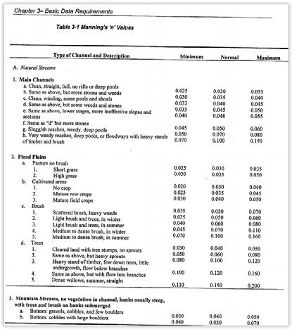
16 COMPUTING A BFE Example Cross-section Mannings n out of bank Mannings n channel Changes in n 31 COMPUTING A BFE Compute 1% Flood Flow using SCS TR-55 Delineate Drainage area to POI from USGS Map Start at downstream cross-section, delineate DA perpendicular to flow. Planimeter or scale DA from CAD drawing. PASDA mapping used to determine ground cover/land use


17 COMPUTING A BFE Compute 1% Flood Flow using SCS TR-55 Use Web soil survey to look up Hydrologic Soil Groups. Compute weighted CN for each land use and HSG. Use NOAA Atlas 14 for 24-hour rainfall data 33 COMPUTING A BFE Use NOAA Atlas 14 rainfall data or Township ordinance. Web site: hdsc.nws.noaa.gov Click the map for PA. Select Precipitation depth, English units and Partial duration. Type in the address of the site location


18 Using NOAA Atlas 14 rainfall data. Web site: hdsc.nws.noaa.gov Click the map for PA. Select Precipitation depth, English units and Partial duration. Type in the address of the site location. 35 Using NOAA Atlas 14 rainfall data. Use 100-year, 24-hour duration storm. Rainfall = 7.62 Township Code required 8.4 Use 8.4 (conservative) 36 18
19 Using NOAA Atlas 14 rainfall data. Use 100-year, 24- hour duration storm. By selecting the submit button at the bottom of the form, this txt file is created and opened in Excel. Similarly, you may obtain rainfall intensity data by selecting Precipitation Intensity in the first dropdown box. Point precipitation frequency estimates (inches) NOAA Atlas 14 Volume 2 Version 3 Data type: Precipitation depth Time series type: Partial duration Project area: Ohio River Basin Location name (ESRI Maps): Lower Merion Twp Station Name: - Latitude: Longitude: Elevation (USGS): ft Pennsyl vania USA PRECIPITATION FREQUENCY ESTIMATES by duration for ARI (years): min: min: min: min: min: hr: hr: hr: hr: hr: day: day: day: day: day: day: day: day: day: COMPUTING A BFE Compute Time of Concentration to POI 38 19
20 COMPUTING A BFE Compute Peak Flow for 100-year storm 24 Hour Rainfall data from NOAA Atlas 14 (8.4 ) 39 COMPUTING A BFE Compute normal depth at downstream X-Section Velocity V (ft/sec) = (1.486*R 2/3 *S 1/2 )/n Flow Q = A*V, where A = area of cross-section. R=Area/Wetted perimeter (hydraulic radius, in ft). S= Channel slope in ft/ft from starting x-section to next upstream x- section. N = Manning s n. Break up cross-section into each change in n value. (3 parts). Trial and error procedure Slope S is known. (0.014 ft/ft computed from plan) n is known. Hydraulic radius computed for given depth. Q = the capacity of the channel equal to the computed 100-year flow (370 CFS)
 41 COMPUTING A BFE Trial 1 - Compute normal depth at downstream X-Section Design flow Slope: Computed W. S. Elev: 370 CFS 0.014 ft/ft 345.")
21 COMPUTING A BFE Compute normal depth at downstream X-Section Spreadsheet included in notes. (Normal_depth in composite channel, xlsx) 41 COMPUTING A BFE Trial 1 - Compute normal depth at downstream X-Section Design flow Slope: Computed W. S. Elev: 370 CFS ft/ft ft Section Area P R R 2/3 n Velocity Flow TRIAL 1 sf ft ft fps cfs Left Center Right Trial 1 Assuming Velocity = 4 fps, compute required Area of Cross-section. (93 Sq. Ft.) Determine depth of flow (try 345.0), then compute area and wetted perimeter Stationing can be used to compute wetted perimeter. Using Excel, compute Area, and wetted perimeter. Spreadsheet computes R, V and flows. Compare results with Design flow. Trial 1 overestimated depth. Go to trial 2 with lower elevation

22 COMPUTING A BFE Trial 2 - Compute normal depth at downstream X-Section Trial 2 Required Area: 78.7 Computed W. S. Elev: ft Section Area P R R 2/3 n Velocity Flow TRIAL 2 sf ft ft fps cfs Left Center Right Trial 2 Compute required area tor trial 2 using Velocity of Trial Try Compute area and wetted perimeter Using Excel, compute Area, and wetted perimeter. Spreadsheet computes R, V and flows. Compare results with Design flow. Trial 2 underestimated depth, but is close enough to 0.1 ft depth. 43 COMPUTING A BFE Plot the resultant flood depth on the plan Computed flood plain 44 22


23 COMPUTING A BFE USING BACKWATER ANALYSIS Results using HEC-RAS computer software
 or Lowest Lot elevation(s) Other elevation data 47 Documentation for a LOMA FEMA will compute the BFE for single property!")
24 Documentation for a LOMA Required Recorded plat map or A recorded deed accompanied by tax assessor s map May be Required Certified metes and bounds description and map Elevation Form with the certified Lowest Adjacent Grade (LAG) or Lowest Lot elevation(s) Other elevation data 47 Documentation for a LOMA FEMA will compute the BFE for single property! Types of LOMAs Removal of structure(s) or removal of a portion or all of a property described by metes and bounds. Required information In order to analyze the property, an accurate survey tied to FEMA datum is required. Form MT EZ (elevation form) used to describe the property elevations. An elevation certificate is also suggested. Required Recorded plat map or A recorded deed accompanied by tax assessor s map May be Required Certified metes and bounds description and map for portion of property to be removed

25 Form MT EZ 49 Form MT EZ May not be used if fill placed to raise ground below the BFE. Check the appropriate block for the removal request


26 Form MT EZ Complete for either structure or land removal. Complete property Information 51 Form MT EZ Complete Geographic information using FEMA FIS datum. Use Google Earth for Latitude and Longitude data or GNSS Complete FIRM information from your Firmette. For Zone A, there will be no BFE (indicate none or N/A). Sign and seal the document

27 Common Application Issues LOMAs Failure to write the legal property description and address on the application Failure to enter contact information and sign/date the application Submitting a deed or plat map that is not recorded Missing vertical datum on the Elevation Form Elevations not based on finished construction for an as built determination 53 Online LOMC Allows a FIRM amendment or revision to be requested through an online platform instead of mailing in an application Supporting documentation can be uploaded online and case related correspondence is e mailed to the applicant 54 27
28 eloma Eligibility Eligible for eloma Structure/lot on natural ground Single structure/lot Existing structure Zones A1 30 (except in floodway), AE (except in floodway), and AH New LOMA requests Subject area on FIRM panel has not been revised by a LOMR Structure/lot located on land that has not been annexed Not Eligible for eloma Structure/lot elevated by fill Multiple structures/lots; condominiums Proposed construction Zones A, V, VE, V1 V30, AO, D, B, C, X Re issuances or LOMAs in progress Subject area on FIRM panel revised by LOMR Structure/lot located on annexed land 55 Resources FEMA Map Information exchange (FMIX) Toll free by phone at By at FEMAMapSpecialist@riskmapcds.com FEMA Map Service Center National Flood Hazard Layer FEMA GeoPortal eloma (Mapping Information Platform) Online LOMC Code of Federal Regulations LOMC Fee Information FEMA Forms NFIP Technical Bulletins USGS Vertical Datum Conversion Information 56 28

29 The National Flood Hazard Layer FEMA s nationwide geospatial database of all digital effective FIRM data Integrates FIRM data including LOMCs nightly Available in GIS format FIRM and FIS are still the official source of data Available in 3 platforms 57 Creating a FIRMette Tool on the Map Service Center that takes a snap shot from a larger FIRM Captures map panel, scale, and selected area to zoom in on Useful for floodplain determinations Would you like a demo? 58 29
30 Questions? 59 30
Letter of Map Change Fundamentals
 Letter of Map Change Fundamentals FEMA Region III National Flood Insurance Program Essentials and Best Practices Jana Green, CFM, RAMPP Topics of Discussion Why Apply for a Letter of Map Change (LOMC)?
National Flood Insurance Program (NFIP) MT-1 Presentation. David Mummert, Michael Baker Jr., Inc.
 MT-1 Presentation. David Mummert, Michael Baker Jr., Inc.") National Flood Insurance Program (NFIP) MT-1 Presentation David Mummert, Michael Baker Jr., Inc. MT-1 Letters of Map Change (LOMCs) LOMC Review By FEMA FEMA required to notify the applicant in writing
National Flood Insurance Program (NFIP) MT-1 Presentation David Mummert, Michael Baker Jr., Inc. MT-1 Letters of Map Change (LOMCs) LOMC Review By FEMA FEMA required to notify the applicant in writing
MT 1, MT 2, Elevation Certificates & the Role of Surveyors
 MT 1, MT 2, Elevation Certificates & the Role of Surveyors Rocky Mountain Surveyors Summit March 3, 2016 Floods are acts of God, but flood losses are largely acts of man. - Dr. Gilbert White the father
Criteria for Appeals of Flood Insurance Rate Maps. November 30, 201 1
 Criteria for Appeals of Flood Insurance Rate Maps November 30, 201 1 This document outlines the criteria for appealing proposed changes in flood hazard information on Flood Insurance Rate Maps (FIRMS)
Chapter 5. Floodplain Management. 5.0 Introduction. 5.1 Floodplain Management and Regulation
 5.0 Introduction This chapter summarizes the Town s rules and regulations regarding floodplain management and development. The requirements presented in this chapter should be used by the design engineer
Chapter 5. Floodplain Management. 5.0 Introduction. 5.1 Douglas County Comprehensive Master Plan. 5.2 Floodplain Management and Regulation
 5.0 Introduction This chapter summarizes the County s rules and regulations regarding floodplain management and development. The requirements presented in this chapter should be used by the design engineer
Federal Emergency Management Agency
 Page 1 of 3 Date: July 21, 2016 Case No.: 16-05-5203A LOMA COMMUNITY AND MAP PANEL INFORMATION COMMUNITY KEWAUNEE COUNTY, WISCONSIN (Unincorporated Areas) Federal Emergency Management Agency Washington,
Letters of Map Amendment- Out as Shown
 Letters of Map Amendment- Out as Shown While digital Flood Insurance Rate Maps (DFIRM s) have made it easier to determine if a structure (or building site) is in the special flood hazard area (SFHA), many
Map Modernization Modernization Program
 FEMA Map Modernization Program Presented to Maryland Association of Floodplain and Stormwater Managers October 27, 2005 Map Modernization Program Autorun.exe 2 Map Modernization Program Outline Map Mod
HEC Software and FEMA Submittals
 HEC Software and FEMA Submittals EWRI Workshop HEC Users Conference Larry Voice Risk Analysis FEMA Region VI April 12, 2010 Overview Flood Hazard Analysis Overview of Map Changes Accepted Model List Guidance
2016 Fredericksburg Area Floodplain Management Workshop Tuesday, October 25, 2016
 2016 Fredericksburg Area Floodplain Management Workshop Tuesday, October 25, 2016 Charley Banks, CFM Department of Conservation And Recreation Division of Dam Safety & Floodplain Management Some Soapbox
Project Name: (Name as it appears in ESNAPS.) Spring Care Association
 Spring Care Association") Page 1 of 4 U.S. Department of Housing and Urban Development 451 Seventh Street, SW Washington, DC 20410 www.hud.gov espanol.hud.gov Environmental Review for Continuum of Care (CoC) Rental Assistance Project
Page 1 of 4 U.S. Department of Housing and Urban Development 451 Seventh Street, SW Washington, DC 20410 www.hud.gov espanol.hud.gov Environmental Review for Continuum of Care (CoC) Rental Assistance Project
FEDERAL EMERGENCY MANAGEMENT AGENCY MITIGATION DIRECTORATE TECHNICAL SERVICES DIVISION AMENDMENTS AND REVISIONS TO
 FEDERAL EMERGENCY MANAGEMENT AGENCY MITIGATION DIRECTORATE TECHNICAL SERVICES DIVISION AMENDMENTS AND REVISIONS TO NATIONAL FLOOD INSURANCE PROGRAM MAPS Application/Certification Forms and Instructions
ELEVATION CERTIFICATE
 ELEVATION CERTIFICATE IMPORTANT: In these spaces, copy the corresponding information from Section A. FOR INSURANCE COMPANY USE Building Street Address (including Apt., Unit, Suite, and/or Bldg. No.) or
Mingo County, WV Community Coordination Preliminary Flood Insurance Study and Flood Insurance Rate Map. Thursday, September 25, 2014
 Mingo County, WV Community Coordination Preliminary Flood Insurance Study and Flood Insurance Rate Map Thursday, September 25, 2014 Overview Preliminary Materials Preliminary FIS Report Digital Flood Insurance
Overview of Federal and State Floodplain Management Programs
 Overview of Federal and State Floodplain Management Programs Peter DeMeo, PE Supervising Environmental Engineer New Jersey Department of Environmental Protection Division of Land Use Regulation October
Floodplain Development Land Use Review
 PUBLIC WORKS - COMMUNITY DEVELOPMENT 333 Broadalbin Street SW, PO Box 490, Albany, Oregon 97321-0144 BUILDING 541-917-7553 PLANNING 541-917-7550 Floodplain Development Land Use Review Application Information
What s New in FEMA Mapping?
 Discussion Topics What s New in FEMA Mapping? Eric Simmons September 6, 2018 FEMA Initiatives & Evolving Risk MAP FEMA s Flood Map Service Center National Flood Hazard Layer (NFHL) Draft NFHL and Changes
FEMA POLICY: GUIDANCE ON THE USE OF AVAILABLE FLOOD HAZARD INFORMATION
 FEMA POLICY: GUIDANCE ON THE USE OF AVAILABLE FLOOD HAZARD INFORMATION FEMA Policy #104-008-2 BACKGROUND The policy is for FEMA Headquarters, Regional program staff, and for the Field Staff at the Joint
Date of Review: 11/6/2015 Reviewer: RCQ/LMC STATE
 FINAL Florida Review Checklist: NFIP & FBC & Revised Model Ordinance (January 15, 2013d) Ordinance Citation: Model FPM regulations and 5 th Edition FBC : All Zones Date of Review: 11/6/2015 Reviewer: RCQ/LMC
Flood Hazard Development Permit Application & Permit Forms. For Communities with Coastal Velocity Zones [60.3(e)] CONTENTS
![Flood Hazard Development Permit Application & Permit Forms. For Communities with Coastal Velocity Zones [60.3(e)] CONTENTS](/thumbs/76/74346075.jpg "Flood Hazard Development Permit Application & Permit Forms. For Communities with Coastal Velocity Zones [60.3(e)] CONTENTS") Flood Hazard Development Permit Application & Permit Forms For Communities with Coastal Velocity Zones [60.3(e)] CONTENTS 1. Decision Tree 2. Flood Hazard Development Permit Application 3. Flood Hazard
Flood Hazard Development Permit Application & Permit Forms For Communities with Coastal Velocity Zones [60.3(e)] CONTENTS 1. Decision Tree 2. Flood Hazard Development Permit Application 3. Flood Hazard
DIVISION 1. - GENERAL PROVISIONS
 Sec. 90-708. - Statutory authorization and purpose. Sec. 90-709. - Applicability. Sec. 90-710. - Compliance and liability. Sec. 90-711. - Records. Sec. 90-712. - Abrogation and greater restrictions. Sec.
Township of Little Egg Harbor Planning Board 665 Radio Road Little Egg Harbor, New Jersey Phone: ext. 221 Fax:
 BLOCK(S) LOT(S) Township of Little Egg Harbor Planning Board 665 Radio Road Little Egg Harbor, New Jersey 08087 Phone: 609-296-7241 ext. 221 Fax: 609-294-3040 Development Application Amended Development
Oxford Floodplain Management Ordinance
 Table of Contents SECTION 1.0 GENERAL PROVISIONS...1 1.1 Findings...1 1.2 Statutory Authorization...1 1.3 Statement of Purpose...1 1.4 Areas to Which These Regulations Apply...2 1.5 Basis for Establishing
1/23/2017. Floodplain Update For Surveyors. Floodplain Updates For Surveyors. Sample FEMA Map with SFHA
 Floodplain Updates For Surveyors Ceil Strauss MN State Floodplain Manager February 9, 2017 Floodplain Update For Surveyors Finding FEMA Maps & Data Map / Data Updates & Status Other useful resources Letters
CITY OF CAMBRIDGE FLOODPLAIN MANAGEMENT CHAPTER 7 (GRADING, EROSION AND SEDIMENT CONTROL)
") CITY OF CAMBRIDGE FLOODPLAIN MANAGEMENT CHAPTER 7 (GRADING, EROSION AND SEDIMENT CONTROL) City of Cambridge, MD Floodplain Management Ordinance (Tidal): May, 2011 1 City of Cambridge, Maryland Floodplain
CITY OF CAMBRIDGE FLOODPLAIN MANAGEMENT CHAPTER 7 (GRADING, EROSION AND SEDIMENT CONTROL) City of Cambridge, MD Floodplain Management Ordinance (Tidal): May, 2011 1 City of Cambridge, Maryland Floodplain
Final Report WI Flood Map Maintenance Project. Prepared For. The Wisconsin Department of Natural Resources Flood Map Maintenance Project
 Final Report WI Flood Map Maintenance Project Prepared For The Wisconsin Department of Natural Resources Flood Map Maintenance Project December 2007 TABLE OF CONTENTS INTRODUCTION 1 GIS DATA INVENTORY
MAP INDEX CHECKLIST NOTES:
 REVIEWING YOUR PRELIMINARY DFIRM PANELS AND FIS REPORT A GUIDE FOR COMMUNITY OFFICIALS When a Georgia community is presented with new Digital Flood Insurance Rate Map (DFIRM) panels, the State of Georgia,
E L M E R B O R O U G H L A N D U S E B O A R D APPLICATION COVER SHEET (to be completed for all applications and appeals)
") E L M E R B O R O U G H L A N D U S E B O A R D APPLICATION COVER SHEET (to be completed for all applications and appeals) 1. Name(s): 2. Address: 3. Telephone Number(s): 4. E-mail: 5. Owner Name(s) (if
E L M E R B O R O U G H L A N D U S E B O A R D APPLICATION COVER SHEET (to be completed for all applications and appeals) 1. Name(s): 2. Address: 3. Telephone Number(s): 4. E-mail: 5. Owner Name(s) (if
2412 E. 26TH ST E 26th St, Minneapolis, MN 55406
 SALE PRICE: $425,000 LOT SIZE:.17 Acres BUILDING SIZE: +/-2,400 SF DRIVE-IN DOORS 1 CEILING HEIGHT: 14' YEAR BUILT: 1970 ZONING: I2 Medium Industrial District PROPERTY OVERVIEW Small shop, flexible office
TOWNSHIP OF BORDENTOWN LAND DEVELOPMENT APPLICATION CHECKLIST. General Requirements for all Applications
 TOWNSHIP OF BORDENTOWN LAND DEVELOPMENT APPLICATION CHECKLIST This CHECKLIST has been adopted in accordance with Section 25:807 of the Land Development Ordinance of the Township of Bordentown and will
Waseca County Planning and Zoning Office
 Waseca County Planning and Zoning Office 300 North State Street Waseca, Minnesota 56093 Phone: 507-835-0650 Fax: 507-837-5310 Form no. PZ 081009 Web Site: www.co.waseca.mn.us FEES: 1) CUP FEE- $400.00
PLANNING BOARD CITY OF CONCORD, NH MINOR SUBDIVISION CHECKLIST
 PLANNING BOARD CITY OF CONCORD, NH MINOR SUBDIVISION CHECKLIST Summary This checklist is intended to assist applicants and design professionals in the preparation of minor subdivision applications for
APPLICATION PROCEDURE
 ANTRIM PLANNING BOARD P. O. Box 517 Antrim, New Hampshire 03440 Phone: 603-588-6785 FAX: 603-588-2969 APPLICATION FORM AND CHECKLIST FOR MINOR OR MAJOR SITE PLAN REVIEW File Date Received By APPLICATION
Map Modernization State Business Plan for Ohio January 2004 Attachment #2
 Map Modernization State Business Plan for Ohio January 2004 Attachment #2 FEDERAL EMERGENCY MANAGEMENT AGENCY COOPERATING TECHNICAL PARTNERS MEMORANDUM OF AGREEMENT AGREEMENT is made on April 22, 2003,
RD:VMT:NGA ORD. NO /3/09 ORDINANCE NO
 ORDINANCE NO. 28512 AN ORDINANCE OF THE CITY OF SAN JOSE AMENDING CHAPTER 17.08 OF TITLE 17 OF THE SAN JOSE MUNICIPAL CODE TO UPDATE THE CITY S SPECIAL FLOOD HAZARD REGULATIONS WHEREAS, the Council of
MASON COUNTY FLOODPLAIN ORDINANCE
 MASON COUNTY FLOODPLAIN ORDINANCE September 2013 AUTHORITY AND PURPOSE: AN ORDINANCE ESTABLISHING A FLOODPLAIN AREA AND REQUIRING ALL CONTRACTORS, PERSONS, PARTNERSHIPS, BUSINESSES, AND CORPORATIONS TO
Initial Subdivision Applications Shall Include the Following:
 Initial Subdivision Applications Shall Include the Following: 1) Subdivision Application Form: completely filled out (12 copies) 2) Plat: The Plat must adhere to the requirements set forth in the Town
WAYNE COUNTY, WV FLOODPLAIN ORDINANCE
 WAYNE COUNTY, WV FLOODPLAIN ORDINANCE AUTHORITY AND PURPOSE: AN ORDINANCE ESTABLISHING A FLOODPLAIN AREA AND REQUIRING ALL CONTRACTORS, PERSONS, PARTNERSHIPS, BUSINESSES, AND CORPORATIONS TO OBTAIN A PERMIT
Residential Major Subdivision Review Checklist
 Residential Major Subdivision Review Checklist Plan Submittal Requirements: 2 full sets of stamped plans Electric submittal - all plans contained in a single PDF 3 full sets if commercial kitchen or dining
CITY OF AUSTELL DESIGN AND CONSTRUCTION STANDARDS LAND DEVELOPMENT ORDINANCES
 CITY OF AUSTELL DESIGN AND CONSTRUCTION STANDARDS LAND DEVELOPMENT ORDINANCES Land Development Ordinances Section 8 CITY OF AUSTELL DESIGN AND CONSTRUCTION STANDARDS LAND DEVELOPMENT ORDINANCES Article
MAJOR SUBDIVISION PRELIMINARY PLAT CHECKLIST
 TOWNSHIP OF EGG HARBOR PLANNING BOARD/ZONING BOARD OF ADJUSTMENT 3515 BARGAINTOWN ROAD EGG HARBOR TOWNSHIP, NJ 08234 MAJOR SUBDIVISION PRELIMINARY PLAT CHECKLIST The following checklist is designed to
City Of Attleboro Conservation Commission
 City Of Attleboro Conservation Commission GOVERNMENT CENTER, 77 PARK STREET ATTLEBORO, MASSACHUSETTS 02703 (508) 223 2222 FAX 222 3046 GENERAL INSTRUCTIONS AND CHECKLIST FOR COMPLETING STORMWATER MANAGEMENT
(Chapter Flood Damage Prevention)
") Chapter 13.10 Flood Damage Prevention Section: 13.10.010 Purpose and Policy 13.10.020 Definitions 13.10.030 Applicability and Areas of Special Flood Hazard 13.10.040 Administration 13.10.050 Provisions
Chapter 13.10 Flood Damage Prevention Section: 13.10.010 Purpose and Policy 13.10.020 Definitions 13.10.030 Applicability and Areas of Special Flood Hazard 13.10.040 Administration 13.10.050 Provisions
BRIDGETON SUBDIVISION APPLICATION CHECKLIST
 APPLICATION NAME AND # CHECKLIST COMPLETED BY: DATE: Signature and printed name BRIDGETON SUBDIVISION APPLICATION CHECKLIST TO SUBDIVISION APPLICANTS: The attached checklist is to assist you in the submission
Tentative Map Application Review Procedures
 FOR REFERENCE ONLY This page is not part of the application. Tentative Map Application Review Procedures The tentative map process in Churchill County is designed to provide a mechanism in order to divide
CHAPTER 24 F FLOOD ZONE OVERLAY DISTRICT
 CHAPTER 24 OVERLAY DISTRICT SECTION 24.01 PURPOSE It is the intent of this district to apply special regulation to the use of land in those areas subject to periodic inundation. Such regulation is deemed
Cibola County Floodplain Development Permit Application
 Cibola County Floodplain Development Permit Application Application # FP Use Permit Variance Appeal Permit Fee $25.00 Date SECTION I: GENERAL PROVISIONS (APPLICANT to read and sign) 1. No work of any kind
SECTION 10: FLOOD HAZARD EVALUATION 10-1
 10) SECTION 10: FLOOD HAZARD EVALUATION A. General. Land subject to being flooded by a Flood of 100-Year Frequency as defined by Title 76, Chapter 5, MCA, or land subject to flooding pursuant to these
Appendix E: Hydrologic & Hydraulic Report. Proposed Bridge Replacement SR 1008, Section 02B (Henry Road) Over Bushkill Creek
 Over Bushkill Creek") Hydrologic & Hydraulic Report Proposed Bridge Replacement SR 1008, Section 02B (Henry Road) Over Bushkill Creek Appendix E: Existing Conditions Hydraulic Analysis 425 Bushkill Creek Henry Woods WS 500-yr
Hydrologic & Hydraulic Report Proposed Bridge Replacement SR 1008, Section 02B (Henry Road) Over Bushkill Creek Appendix E: Existing Conditions Hydraulic Analysis 425 Bushkill Creek Henry Woods WS 500-yr
Residential Subdivision Preliminary Plat Application
 WATER MODELING FEES Major : $650 or Minor : $550 # of lots x $35 per lot Residential Preliminary Plat Application Lots: 1-9 10-19 20-49 50-99 100-199 $300 $400 $475 $625 $825 200-349 350-499 500-499 700-999
ORDINANCE ARTICLE VI. RESOURCE PROTECTION STANDARDS
 ORDINANCE 2016-19 AN ORDINANCE OF THE CITY OF LAKE WALES, POLK COUNTY, FLORIDA AMENDING THE CITY OF LAKE WALES CODE OF ORDINANCES BY REPEALING CHAPTER 23 ZONING, LAND USE AND DEVELOPMENT REGULATIONS, ARTICLE
MODEL FLOODPLAIN MANAGEMENT / FLOOD DAMAGE PREVENTION ORDINANCE
 MODEL FLOODPLAIN MANAGEMENT / FLOOD DAMAGE PREVENTION ORDINANCE Description: Floodplain management involves the designation of flood-prone areas and the managing of their uses. It is also aimed at minimizing
6. Help maintain a stable tax base by providing for the sound use and development of flood hazard areas;
 CHAPTER 9 FLOODPLAIN MANAGEMENT SECTION 101 GENERAL 101.1 Title. These regulations shall be known as the Floodplain Management Ordinance of Yankeetown, hereinafter referred to as this ordinance. 101.2
COMMERCIAL SITE DEVELOPMENT GUIDE FOR UNINCORPORATED ST. CHARLES COUNTY
 COMMERCIAL SITE DEVELOPMENT GUIDE FOR UNINCORPORATED ST. CHARLES COUNTY GENERAL INFORMATION: This brochure is to be used as a guide and is not intended to amend or supersede the corresponding County ordinances
ARTICLE V PRELIMINARY PLAN SUBMISSION
 ARTICLE V PRELIMINARY PLAN SUBMISSION 501. Plan Requirements a. On or before the 25 th day of the month prior to a regularly scheduled meeting of the Planning Commission, the applicant shall submit two
Appendix A Reproducible Forms
 Appendix A Reproducible Forms Form LD-33 LD-34 LD-35 LD-40 LD-41 LD-42 LD-50 LD-51 LD-52 LD-53 Subject County Engineer Approval Form Storm Sewer Computation Sheet Ohio Drainage Design Criteria Form Gutter
FLOOD DAMAGE REDUCTION RESOLUTION GREENE COUNTY, OHIO
 FLOOD DAMAGE REDUCTION RESOLUTION GREENE COUNTY, OHIO SECTION 101.01: GENERAL PROVISIONS 101.01.1 Statutory Authorization This resolution is adopted pursuant to authorization contained in Sections 307.37
PRELMINARY PLAT CHECKLIST
 PRELMINARY PLAT CHECKLIST A. All preliminary plat submitted for approval shall be prepared by a Registered Professional Land Surveyor. B. Preliminary plats must be drawn to a scale of XXX with such accuracy
PLANNING BOARD APPLICATION FORM TOWNSHIP OF BETHLEHEM 405 MINE ROAD ASBURY, NEW JERSEY Date of Application: Township Application Number:
 Township of Bethlehem Page 1 of 8 PLANNING BOARD APPLICATION FORM TOWNSHIP OF BETHLEHEM 405 MINE ROAD ASBURY, NEW JERSEY 08802 Date of Application: Township Application Number: Jurisdiction: Planning Board
NOTICE
 www.ketteringoh.org NOTICE This City of Kettering Code section is not the official version and is provided only for the convenience of the public. The only official version of the City of Kettering Code
SUBDIVISION APPLICATION CHECKLIST SKETCH PLAN PRELIMINARY PLAT FINAL PLAT
 RECEIVED STAMP SUBDIVISION APPLICATION CHECKLIST SKETCH PLAN PRELIMINARY PLAT FINAL PLAT A checklist of background information and submission requirements for processing of a sketch plan, preliminary plat
Developing Mitigation Projects. Molly J. O Toole, P.E., D.WRE, CFM
 Developing Mitigation Projects Molly J. O Toole, P.E., D.WRE, CFM Mitigation Hazard mitigation is defined as any sustained action taken to reduce or eliminate long-term risk to life and property from a
Chapter 8 FLOOD PREVENTION AND PROTECTION
 Chapter 8 FLOOD PREVENTION AND PROTECTION ARTICLE I - GENERAL 8.1 Title. 8.2 Scope. 8.3 Intent. 8.4 Coordination with the Florida Building Code. 8.5 Warning. 8.6 Disclaimer of Liability. 8.7 through 8.10
ARTICLE 5 MINOR SUBDIVISION/LAND DEVELOPMENT
 ARTICLE 5 MINOR SUBDIVISION/LAND DEVELOPMENT SECTION 501 ONLY FINAL PLAN REQUIRED The classification of a proposed subdivision as a "Minor Subdivision" shall only require the submission, review and approval
Alberta Flood Hazard Identification Program
 Alberta Flood Hazard Identification Program Peter Onyshko, P.Eng., CFM River Forecast Section Alberta Environment and Parks November 5, 2015 Flood Hazard Identification Program Presentation Outline Introduction
NOTICE OF LAND USE DECISION BY THE COOS COUNTY PLANNING DIRECTOR
 NOTICE OF LAND USE DECISION BY THE COOS COUNTY PLANNING DIRECTOR Coos County Planning 225 N. Adams St. Coquille, OR 97423 http://www.co.coos.or.us/ Phone: 541-396-7770 Fax: 541-396-1022 This notice is
Residential Minor Subdivision Review Checklist
 Residential Minor Subdivision Review Checklist Plan Submittal Requirements: 2 full sets of stamped plans Electric submittal - all plans contained in a single PDF 3 full sets if commercial kitchen or dining
ORD-3309 BE IT ORDAINED BY THE CITY COUNCIL OF THE CITY OF VIRGINIA BEACH, VIRGINIA:
 ORD-3309 1 2 3 4 5 6 7 8 9 10 11 12 13 14 15 16 17 18 19 20 21 22 23 24 25 26 27 28 29 30 31 32 33 34 35 36 37 38 39 40 41 42 43 44 45 AN ORDINANCE TO ADOPT APPENDIX K, (FLOODPLAIN ORDINANCE) OF THE CITY
Town of Middleborough Conservation Commission 2014 Policy
 Approved February 20, 2014 Town of Middleborough Conservation Commission 2014 Policy The Wetland Protection Act under M.G.L. c. 131, sec. 40 and regulations 310 CMR 10.02(1)(a-f) & 310 CMR 10.02 (2)(a)
On motion by, and seconded by, All Council Members present, the following ordinance was introduced: ORDINANCE 1552
 On motion by, and seconded by, All Council Members present, the following ordinance was introduced: ORDINANCE 1552 An ordinance repealing Chapter 10 BUILDING AND CONSTRUCTION REGULATIONS - Article II Special
LDC AMENDMENT FLOODPLAINS
 Staff Report to the Municipal Planning Board March 20, 2018 L D C 2 0 1 8-10000 I T E M # 4 LDC AMENDMENT FLOODPLAINS Applicant City of Orlando Project Planner Elisabeth Dang, AICP Description of the Request:
(Ord. No. 743, )
") CHAPTER 330. - FLOODPLAIN MANAGEMENT Section 330-1. - Purpose. (a) (b) (c) (d) It is hereby determined that the flood hazard areas of the City of Chamblee are subject to periodic inundation which may result
CHAPTER 330. - FLOODPLAIN MANAGEMENT Section 330-1. - Purpose. (a) (b) (c) (d) It is hereby determined that the flood hazard areas of the City of Chamblee are subject to periodic inundation which may result
CHAPTER 109 NATURAL RESOURCES AND ENVIRONMENTAL PROTECTION. ARTICLE I. Flood Damage Prevention In General
 Sec. 109-1. - Authorization. CHAPTER 109 NATURAL RESOURCES AND ENVIRONMENTAL PROTECTION ARTICLE I. Flood Damage Prevention In General Article IX, Section II of the Constitution of the State of Georgia
TOWNSHIP OF EGG HARBOR ZONING BOARD ADJUSTMENT CHECK LIST
 TOWNSHIP OF EGG HARBOR ZONING BOARD ADJUSTMENT CHECK LIST Schedule A - General Requirements 1. Where the application involves only a variance one (1) original and nineteen (19) copies of the appropriate
October 2011 Flood Insurance Manual
 FEMA NFIP C h a n g e s October 2011 Flood Insurance Manual 1 Significant Revisions The Changes Where to find the Change Building Occupancy Classification Updates Improvements and Betterments Coverage
PRELIMINARY SUBDIVISION AND LAND DEVELOPMENT PLAN CHECKLIST. Applicant's Name:
 TOWNSHIP OF UPPER ST. CLAIR PRELIMINARY SUBDIVISION AND LAND DEVELOPMENT PLAN CHECKLIST Date Filed Plan Name: Applicant's Name: PLC# Phone = OK 0 = Missing; X = Not OK; NA = Not Applicable;? To be Determined;
Projected Expansion of the Floodplain with Sea Level Rise in Westport, Massachusetts Summary
 Projected Expansion of the Floodplain with Sea Level Rise in Westport, Massachusetts Buzzards Bay National Estuary Program and Massachusetts Office of Coastal Zone Management Technical Report SLR13-3 Draft
FLOOD HAZARD AREA LAND USE MANAGEMENT
 FLOOD HAZARD AREA LAND USE MANAGEMENT Introduction Guidance For Selection of Qualified Professionals and Preparation of Flood Hazard Assessment Reports This document is intended to provide guidance for
Town of Alexandria. Floodplain Management Ordinance
 1 of 7 8/8/2009 4:56 PM Town of Alexandria Floodplain Management Ordinance SECTION 1 PURPOSE Certain areas of the Town of Alexandria, New Hampshire are subject to periodic flooding, causing serious damages
TUSCARAWAS COUNTY FLOOD DAMAGE REDUCTION REGULATIONS
 TUSCARAWAS COUNTY FLOOD DAMAGE REDUCTION REGULATIONS 2010 Approved for adoption by ODNR 5/11/07 Adopted by the Board of Tuscarawas County Commissioners Date: October 1, 2007 Resolution No: 736-2007 Revised
BACKGROUND There are 23 flood control structures in the Upper Brushy Creek Water Control and Improvement District (District). See attached map.
. See attached map.") BACKGROUND There are 23 flood control structures in the Upper Brushy Creek Water Control and Improvement District (District). See attached map. The U.S Department of Agriculture - Natural Resources Conservation
BACKGROUND There are 23 flood control structures in the Upper Brushy Creek Water Control and Improvement District (District). See attached map. The U.S Department of Agriculture - Natural Resources Conservation
ARTICLE 16. FLOODPLAIN MANAGEMENT, EROSION AND SEDIMENT CONTROL, AND STORMWATER MANAGEMENT
 ARTICLE 16. FLOODPLAIN MANAGEMENT, EROSION AND SEDIMENT CONTROL, AND STORMWATER MANAGEMENT Title 1. DEFINITIONS AND GENERAL PROVISIONS 2. FLOODPLAIN MANAGEMENT 3. EROSION AND SEDIMENT CONTROL 4. STORMWATER
Flood Plain Administration. Oil & Gas
 Submit this form with your application for addressing YOU MUST PROVIDE A MONROE COUNTY PLAT MAP WITH THIS FORM Property # Owners Name Phone # Company Address Location Of Property Township Project Description
SECTION 10 STANDARD PLATS
 SECTION 10 - STANDARD PLATS Subdivision 1: Purpose Standard Plats allow the subdivision of land into lots smaller than the minimum metes and bounds size in the zoning district, and control road development
***** Subchapter A. GENERAL PROVISIONS ***** PERMIT APPLICATIONS
 105.11. Permit requirements. 105.12. Waiver of permit requirements. Title 25 Environmental Protection Part I. Department of Environmental Protection Subpart C. Protection of Natural Resources Article I.
City of Fort Atkinson
 City of Fort Atkinson FLOODPLAIN ZONING ORDINANCE With Flood Storage Modifications February 4, 2015 ADOPTED by Fort Atkinson City Council November 18, 2014 ORDINANCE NO. 725 The City Council of the City
CHAPTER 1313 Flood Damage Prevention Statutory authorization Exemption from filing a Findings
 11 CHAPTER 1313 Flood Damage Prevention 1313.01 Statutory authorization. 1313.02 Findings of fact. 1313.03 Statement of purpose. 1313.04 Methods of reducing flood losses. 1313.05 Lands to which these regulations
SPECIAL PURPOSE FLOOD DAMAGE REDUCTION RESOLUTION FOR PICKAWAY COUNTY, OHIO
 SPECIAL PURPOSE FLOOD DAMAGE REDUCTION RESOLUTION FOR PICKAWAY COUNTY, OHIO Effective December 7, 2012 Pickaway County Board of Commissioners Glenn D. Reeser Jay H. Wippel Ula Jean Metzler Terry L. Frazier,
SECTION OVERLAY ZONES
 SECTION 3.500 OVERLAY ZONES An Overlay Zone is a supplementary zoning designation placing special restrictions or allowing special uses of land beyond those required or allowed in the Base Zone. The Tillamook
APPLICATION FOR 555 Washington Street Tentative Map Red Bluff, CA Subdivision Map (530) ext Parcel Map.
 ext Parcel Map.") City of Red Bluff Community Development Department Application No. APPLICATION FOR 555 Washington Street Tentative Map Red Bluff, CA 96080 Subdivision Map (530) 527-2605 ext. 3059 Parcel Map Applicant
City of Red Bluff Community Development Department Application No. APPLICATION FOR 555 Washington Street Tentative Map Red Bluff, CA 96080 Subdivision Map (530) 527-2605 ext. 3059 Parcel Map Applicant
Land Use Application
 Land Use Application Check all permits you are applying for in the boxes provided. Submit this application form, the applicable materials listed in the corresponding permit application packet(s) and application
ARMSTRONG COUNTY, PENNSYLVANIA
 ARMSTRONG COUNTY, PENNSYLVANIA (ALL JURISDICTIONS) Armstrong County COMMUNITY NAME COMMUNITY NUMBER APOLLO, BOROUGH OF 420092 APPLEWOLD, BOROUGH OF 420093 ATWOOD, BOROUGH OF 422297 BETHEL, TOWNSHIP OF
Watershed Planning Regulations Oklahoma Municipal City of Tulsa. Urban; Suburban City of Tulsa Watershed Development Regulations. Abstract.
 Topic: Resource Type: State: Jurisdiction Type: Municipality: Year (adopted, written, etc.): 1989 Community Type applicable to: Title: Watershed Planning Regulations Oklahoma Municipal City of Tulsa Document
How to find your home s required finished floor elevation according to City s proposed new Floodplain Ordinance
 City of Mexico Beach New Floodplain Ordinance How to find your home s required finished floor elevation according to City s proposed new Floodplain Ordinance This Ordinance only affects the following property
Zoning Permit Application Cover Page
 Zoning Permit Application Cover Page The City of Belmont performs an initial site inspection prior to issuance of a zoning permit for new construction. Upon receipt of a full and complete application submittal
ANDOVER CODE. Checklist #5 Preliminary Site Plan Conditional Use
 ANDOVER CODE Checklist #5 Preliminary Site Plan Conditional Use Applicant: Block Lot File No. This checklist is for general reference only. Further information may be required by the reviewing authority.
JEFFERSON COUNTY, ALABAMA
 JEFFERSON COUNTY, ALABAMA Major Development Checklist, Notes and Information A Major Development is any proposed new structure or addition to an existing structure which will cause a change in the topography
For public hearing by the Town Council and Planning Commission March 24, 2014
 AN ORDINANCE TO AMEND SECTION 17.0 FLOOD HAZARD OVERLAY DISTRICT FH OF THE ZONING ORDINANCE OF THE TOWN OF SCOTTSVILLE, VIRGINIA BE IT ORDAINED by the Town Council of the Town of Scottsville, Virginia,
LEE COUNTY ORDINANCE NO
 LEE COUNTY ORDINANCE NO. 15-09 AN ORDINANCE AMENDING LEE COUNTY LAND DEVELOPMENT CODE CHAPTERS 6 AND 10 AND CERTAIN SECTIONS OF THE FLORIDA BUILDING CODE TO AUTHORIZE THE BOARD OF ADJUSTMENTS AND APPEALS