SURVEYING BOUNDARIES FORESHORE AND PROPERTY OUTLINE DEFINITIONS JURISDICTIONAL ISSUES TENURE ISSUES PRACTICAL SURVEY ISSUES RECOMMENDATIONS
|
|
|
- Steven Jordan
- 5 years ago
- Views:
Transcription
1 SURVEYING BOUNDARIES OUTLINE DEFINITIONS JURISDICTIONAL ISSUES TENURE ISSUES PRACTICAL SURVEY ISSUES RECOMMENDATIONS
2 DEFINITIONS FORESHORE: the part of the seashore between the high water mark and the low-water water mark OHWM:.the presence and action of the water are so common and usual and so long continued in all ordinary years as to mark upon the soil of the bed of the lake, river, stream, or other body of water a character distinct from that of the banks, both in vegetation and in the nature of the soil itself (OTHER DEFINITIONS ASSOCIATE OHWM WITH TIDES A YEAR ETC.) OTHER DEFINITIONS ASSOCIATE OHWM WITH TIDES - MEAL OF HIGH TIDES FOR BOUNDARY: SEPARATION, NATURAL OR ARTIFICIAL, THAT DEFINES AND MARKS THE EXTENT OF PARCELS OR JURISDICTIONS DELINEATION: THE LEGAL DESCRIPTION OF A BOUNDARY.. DEMARCATION: ESTABLISHMENT OF BOUNDARY ON GROUND. CADASTRAL SURVEY: INCLUDES DEMARCATION AND DELINEATION OF BOUNDARIES..(..(WILL HAVE TO CHANGE THIS FOR MARINE WORK) Ambulatory Boundary: changes in location do not affect the legal status of property jurisdictional limit changes in location do not affect the legal status of property of

3 CHALLENGES LAND SURVEYOR IS OFTEN REQUESTED TO MAKE NEAR INSTANTANEOUS DECISIONS TO DEFINE THE HORIZONTAL EXTENTS OF A VARIABLE VERTICAL DATUM THAT IS INFLUENCE BY MANY NATURAL PHENOMENA. CONSIDERATION MUST BE GIVEN TO JURISPRUDENCE COMMON LAW LAND TENURE PRECISION IT S A BIT LIKE NAVIGATING A MAZE SOME JURISDICTIONS DEFINE OHWM WITH TIDES COURT CASES KEEP IT VAGUE IMPACT OF OUR DECISIONS 0.050m H TOL > V TOL WITH 5% SLOPE 0.500m H TOL > V TOL WITH 5% SLOPE (ST JOHN AVG MHW FOR YEAR RESULTED IN.03m DIFFERENCE > 0.6m H SHIFT)
 (1984 1 S.C.R.86 NEWFOUNDLAND CONTINENTAL SHELF NO COMMENT ON TERRITORIAL SEA) EXCEPTION OF CERTAIN BAYS CONCEPTION BAY (1877,2 (1877,2 APP.CAS.394,46 L.J.P.C.. 71) BASED ON NF COURT OF APPEAL (1983, 145 D.")
4 JURISDICTIONAL ISSUES (FEDERAL OR PROVINCIAL) FEDERAL CLAIM OLWM SEAWARD (1958 GENEVA CONVENTION ON TERRITORIAL SEA-ARTICLE ARTICLE 4) BASED ON SUPREME COURT OF CANADA RULING (1967 S.C.J.. No. 70 BRITISH COLUMBIA ET AL AND CANADA) ( S.C.R.86 NEWFOUNDLAND CONTINENTAL SHELF NO COMMENT ON TERRITORIAL SEA) EXCEPTION OF CERTAIN BAYS CONCEPTION BAY (1877,2 (1877,2 APP.CAS.394,46 L.J.P.C.. 71) BASED ON NF COURT OF APPEAL (1983, 145 D.L.R (3d) 9 (COURT RULED CONTINENTAL SHELF TO FEDS)

5 SUMMARY - FEDERAL CLAIM
6 JURISDICTIONAL ISSUES (FEDERAL or PROVINCIAL) PROVINCIAL CLAIM 3 MILE TERRITORIAL SEA PLUS BAYS DEFINED BY HEADLANDS NEWFOUNDLAND COURT OF APPEAL ( D.L.R. (3d) 9) ANSWERED QUESTION OF A 3 MILE TERRITORIAL SEA IN FAVOR OF NEWFOUNDLAND CROWN LANDS BRANCH MAINTAINS Provincial jurisdiction includes between the jaws of the two points and three miles offshore (assume they mean heads of the bays) Provincial Crown recognizes areas created by the federal navigable waters act (possibly the Canadian Marine Act) i.e. Federal Ports
7 JURISDICTIONAL ISSUES Federal Ports Canadian Marine Act Identified certain marine areas where Transport Canada has administrative control. These areas are listed in the act and generally the descriptions note all navigable waters, including foreshore In NL the Regulations under CMA designates the following areas as Federal Ports Botwood; Come By Chance; Corner Brook; Fortune; Goose Bay; Holyrood; Lewisporte; Long Harbour; Long Pond; Marystown; Port aux Basques; Stephenville Note: regulations do not impact ownership it clearly defines geographic areas within the regulatory authority of Transport Canada.. Control of activities in port, real property held under respective provincial system.

8 SURVEYING BOUNDARIES JURISDICTIONAL ISSUES Special Cases Areas where large tracks of land have been transferred to Feds by an Order in Council eg. Head of Bay d Espoir. In this area the receiving authority may set rules and regulations dealing with land transfers; land usage; leases etc. Possible that most of this area has been transferred back to provincial DFA, so we now have another department regulating tidal boundaries
9 BOUNDARIES SUMMARY JURISDICTIONAL ISSUES Federal government is appealing the Provincial Supreme Court decision to issue jurisdiction of the 3 mile territorial sea to provincial government. Provincial government is appealing the decision to issue jurisdiction of the offshore area to the federal government. CNLOPB set up to deal with offshore mineral resource management Surveyors are left to deal with the overlapping jurisdictional issue on a case by case bases. Receive instructions from one or the other or both???????? (example to follow)
10 TENURE ISSUES (UPLAND OWNERSHIP f (NATURAL BOUNDARY) Provincial Lands Act Section 7 Reservation of Shoreline - sets reservation of 15m and in special cases down to 10m wide defined as follows: 15 meters wide around and adjoining the lake, pond, seashore or foreshore or along each bank of the river was not intended to pass and did not pass to the grantee, lessee or licensee. Section 8 Adverse Claim surveyor to identify adverse claims if identified later in time, surveyor may be liable to the minister for debt due to cover expense of the crown??? Section 36 Adverse Possession abolished after Dec 31, 1976 > show possession prior to Jan 1, 1956 (20 years) PROBLEM SECTION 7 IS VERY AMBIGUOUS NO DEFINITIONS OF SEASHORE OR FORESHORE COMMON PRACTICE TO USE OHWM BUT WHERE IS IT AND HOW IS IT DEFINED (NO DEFINITION IN LANDS ACT OR IN THE LAND SURVEYORS ACT) FOR EXAMPLE:
11 SEASHORE CAN BE VERY STEEP WHERE HORIZONTAL POSITION OF OHWM IS RELATIVELY FIXED.

12 SEASHORE CAN BE VERY STEEP IN SOME PLACES BUT MORE GENTLE SLOPE IN OTHER PLACES.

13 SEASHORE CAN HAVE A VERY GENTLE SLOPE. IS THE FENCE THE LIMIT OF OWNERSHIP IS THE KELP LINE THE LIMIT OF OWNERSHIP, IF YES WHICH LINE? QUESTION? IF ACCRETION OCCURS BECAUSE OF MANMADE INFRASTRUCTURE, THEN WHO GETS THE LAND?
14 SURVEYING BOUNDARIES SEASHORE GENTLE SLOPE WHERE IS OHWM LOWER EDGE OF KELP? UPPER EDGE OF KELP? EDGE OF GREEN VEGETATION? TOP OF SMALL RISE ON THE SHORE? HOW WOULD YOU DEFINE THE OLWM?


15 SURVEYING BOUNDARIES ADVERSE POSSESSION FENCE MANY STRUCTURES IN NL ARE BUILT IN CLOSE PROXIMITY TO WATER WAYS, THE 15m RESERVATION COULD ENCOMPASS THE ENTIRE STRUCTURE. Wharves extend out into the water, many without any documented title. LOOKS LIKE MY BOAT? BUILDING SHORES OUT IN THE BROOK LAND SURVEYOR IS LEFT TO DEFINE WHAT CONSTITUTES A BROOK OR STREAM AND WHAT SHOULD HAVE A RESERVATION MORE GUIDANCE IS NEEDED IN THIS AREA.
16 SHORELINE RESERVATION ISSUES Provincial Crown maintains that they are the riparian owner by virtue of the Crown Lands act which dictates that a reservation must be left or should have been left; hence EROSION or ACCRETION must therefore be with the CROWN Property Law natural boundaries take priority over measured distances, etc. hence measurements are only an indicator of where the natural boundary location was at a certain point in time. (Based on premise that a natural feature best demonstrates the intentions of the granting parties and is less susceptible to error (Fraser vs. Cameron)) boundaries controlled by non-ambulatory or artificial monuments will continue to define location of the boundary regardless of the location of water body (Delap vs Haden)
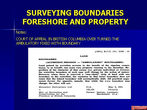
17 FIXED WIDTH AMBULATORY RESERVATION British Columbia case (1978 B.C.L.R. 388) 1 chain Crown reservation defined as being landward of the high water mark (HWM) was held to be ambulatory. The natural HWM controlled the position of the seaward boundary. The court ruled the landward boundary was governed by the width as no other measurements fixed its location by holding the width constant the reservation was also protected LOCATION OF UP LAND BOUNDARIES IN NL MANY SURVEYORS USE A STATEMENT. Thence along the sinuosities of the landward limit of a shoreline reservation, 15m wide, for the waters of Harbour X, to a point, the said point.. This fits the fixed width ambulatory reservation case of BC and hence properties so described in NL benefit or suffer as a result of erosion and accretion, the Crowns reservation would be maintained???
18

19 EXAMPLES OF SURVEYS OHWM & OLWM FIXED BOUNDARY CONTROLLED BY COORDINATES, BEARINGS, DISTANCES AND WITNESS POST AMBULATORY BOUNDARY OLWM AMBULATORY BOUNDARY OHWM
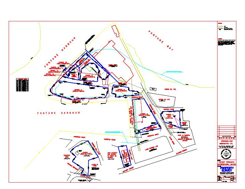


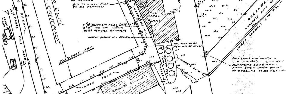
20 INACCESSIBLE EVIDENCE DUE TO HUMAN INTERFERENCE SEA WALL FORTUNE FISH PLANT

21 BOUNDARIES INACCESSIBLE EVIDENCE DUE TO THE POWERS OF NATURE. SURVEYOR WOULD HAVE A HARD TIME DEFINING OHWM OR OLWM AT THIS SITE.
22 BOUNDARIES SAMPLE AQUACULTURE SURVEY NOTE DISTANCES FROM OLWM PER SURVEY INSTRUCTIONS NOTE POSITION OF CAUTIONARY BUOYS (CORNER MARKERS) PLACED WITH HAND HELD GPS BY NON SURVEY PERSONNEL???
23 BOUNDARIES SHORELINE AT LOCATION OF PREVIOUS SURVEY >> NO WAY TO MARK IT WITH WITNESS POSTS OR EVEN GET ASHORE SAFELY. BEST GUESS OF OLWM AND LEAVE EXTRA SPACE TO EXCEED REQUIREMENTS OF SURVEY INSTRUCTIONS

24 BOUNDARIES TYPICAL AQUACULTURE SITE ON SOUTH COAST OF NL
25 BOUNDARIES EXAMPLE - CONFLICTING JURISDICTION FEDERAL PORT PLACENTIA BAY AREA OF JURISDICTIONAL DISPUTED EXISTING CABLE ROUTE +/- EXISTING CABLE INSTALLED ON SEA FLOOR- COMPANY WAITING EASEMENT DOCUMENTS - INSTRUCTIONS ISSUED BY PROVINCIAL CROWN BUT THEN PUT ON HOLD WAITING RESPONSE FROM JUSTICE re FEDERAL GOVERNMENT JURISDICTIONAL CLAIM. COMPANY STILL WAITING AND POSSIBLY LARGE AMOUNT OF $$$$$$ TIED UP WE NEED TO GET THIS SETTLED!
Coastal Shore Jurisdiction in British Columbia
 ISSUE SHEET October 2009 Coastal Shore Jurisdiction in British Columbia Ju ris dic tion: the power, right and authority to interpret and apply the law. (Merriam Webster on-line) Who s in charge of coastal
Ministry of Forest, Lands and Natural Resource Operations
 WHEREAS: PROVINCIAL GENERAL PERMISSION FOR THE USE OF CROWN LAND FOR PRIVATE MOORAGE VERSION: January 17, 2017 (Land Act) A. The Ministry of Forests, Lands and Natural Resource Operations ( the Ministry
Ensure community interests are protected with respect to the management and disposition of public land;
 Energy, Mines and Resources Land Management Branch 320-300 Main Street Whitehorse, Yukon Y1A 2B5 667-5215 Fax 667-3214 www.emr.gov.yk.ca WATER LOT LEASE Land Application Policy OBJECTIVE To allow for land
Waterfront Titles in Washington
 Waterfront Titles in Washington WLTA Education Seminar Lynnwood, Washington October 20, 2012 George Peters Disclaimer: When in comes to water and title insurance the operative term is: CYA Control your
Easement Survey of Underground Waterline for Cold Ocean Salmon Inc.
 2017 Easement Survey of Underground Waterline for Cold Ocean Salmon Inc. Survey Project Technical Report Ryan G. Billard February 20, 2017 Easement Survey of Underground Waterline for Cold Ocean Salmon
Competing Rights to our Natural Resources and Privileges to the Shore March 30, 2016
 Competing Rights to our Natural Resources and Privileges to the Shore March 30, 2016 Prof. Dennis Esposito Director Environmental and Land Use Clinical Externship Program; Adjunct Prof. Marine Affairs
DISTRICT OF NORTH SAANICH B Y L A W N O A BYLAW TO MITIGATE COASTAL FLOODING HAZARDS
 DISTRICT OF NORTH SAANICH B Y L A W N O. 1439 A BYLAW TO MITIGATE COASTAL FLOODING HAZARDS WHEREAS: A. If a flood plain has been designated in a District bylaw, the Local Government Act requires that the
Rules for Cadastral Survey 2010
 Rules for Cadastral Survey 2010 LINZS65000 24 May 2010 www.linz.govt.nz Under section 49 of the Cadastral Survey Act 2002, I hereby make the Rules for Cadastral Survey 2010 These Rules are effective from
Crown Land Use Operational Policy: Trapline Cabin Policy APPROVED AMENDMENTS: Summary of Changes: Note /Approval
 Crown Land Use Operational Policy: Trapline Cabin Policy APPROVED AMENDMENTS: Effective date May 3, 2014 September 22, 2015 February 29 th, 2016 Briefing Note /Approval FLNR DN #205239 BN 217947 Email
FLOOD HAZARD AREA LAND USE MANAGEMENT
 FLOOD HAZARD AREA LAND USE MANAGEMENT Introduction Guidance For Selection of Qualified Professionals and Preparation of Flood Hazard Assessment Reports This document is intended to provide guidance for
EXPERIMENTAL AQUACULTURE LEASE APPLICATION
 EXPERIMENTAL AQUACULTURE LEASE APPLICATION This is an application for an experimental aquaculture lease. You are encouraged to review the experimental lease regulations and application instructions to
(10) The Board has the powers and duties of an arbitrator under sections 29(3) and 43 of the Arbitration Act.
 The Board has the powers and duties of an arbitrator under sections 29(3) and 43 of the Arbitration Act.") Surveys Act [Fall 2014 STATUTE LAW] Under section 9 survey error investigation of the Surveys Act. The Minister may appoint a Board consisting of three (3) members. a. List two (2) of the three (3) members.
Surveys Act [Fall 2014 STATUTE LAW] Under section 9 survey error investigation of the Surveys Act. The Minister may appoint a Board consisting of three (3) members. a. List two (2) of the three (3) members.
Canadian Generally Accepted Land Sur veying Principles
 Canadian Council on Geomatics Conseil canadien de géomatique Canadian Generally Accepted Land Sur veying Principles Part 1 Principles to guide the development of Land Surveying governance models and legal
250 CMR: BOARD OF REGISTRATION OF PROFESSIONAL ENGINEERS AND LAND SURVEYORS DRAFT FOR DISCUSSION PURPOSES ONLY
 250 CMR 6.00: LAND SURVEYING PROCEDURES AND STANDARDS Section 6.01: Elements Common to All Survey Works 6.02: Survey Works of Lines Affecting Property Rights All land surveying work is considered work
APPLICATION GUIDE. MARINE AQUACULTURE (East Coast)
") APPLICATION GUIDE MARINE AQUACULTURE (East Coast) Department of Agriculture, Aquaculture and Fisheries October 2011 TABLE OF CONTENTS 1. INTRODUCTION... 3 2. THE APPLICATION FORM AND SCHEDULES... 4 2.1
APPLICATION GUIDE MARINE AQUACULTURE (East Coast) Department of Agriculture, Aquaculture and Fisheries October 2011 TABLE OF CONTENTS 1. INTRODUCTION... 3 2. THE APPLICATION FORM AND SCHEDULES... 4 2.1
REGIONAL DISTRICT OF NANAIMO BYLAW NO. 1469
 REGIONAL DISTRICT OF NANAIMO BYLAW NO. 1469 A BYLAW TO ESTABLISH FLOODPLAINS, CONSTRUCTION LEVELS IN FLOODPLAINS, AND SETBACKS FOR LANDFILL AND STRUCTURES IN FLOODPLAINS WHEREAS Section 910 of the Local
ORDINANCE NO WHEREAS, the Town of Jupiter ( Town ) has adopted a Comprehensive Plan
 has adopted a Comprehensive Plan") 0 0 ORDINANCE NO. -0 AN ORDINANCE OF THE TOWN COUNCIL OF THE TOWN OF JUPITER, FLORIDA, AMENDING CHAPTER OF THE TOWN CODE TO AMEND SECTION -, ENTITLED INTENT TO ADD PERMITTING LANDGUAGE; TO AMEND SECTION
0 0 ORDINANCE NO. -0 AN ORDINANCE OF THE TOWN COUNCIL OF THE TOWN OF JUPITER, FLORIDA, AMENDING CHAPTER OF THE TOWN CODE TO AMEND SECTION -, ENTITLED INTENT TO ADD PERMITTING LANDGUAGE; TO AMEND SECTION
Crown Land Use Policy: Industrial - General APPROVED AMENDMENTS: Summary of Changes: /Approval
 APPROVED AMENDMENTS: Effective Date Briefing Note /Approval Summary of Changes: March 22, 2011 BN175798 Amendment to clarify pricing for aquatic lands. March 31, 2011 BN 175892 Policy and Procedure update
Chapter 19. Water, Riparian, and Foreshore Rights. Key Terms. Water Rights. Riparian Rights. Chapter 19: Water, Riparian, and Foreshore Rights
 207 Chapter 19 Water, Riparian, and Foreshore Rights This chapter provides some basic background information and lists resources for research projects relating to water, riparian and foreshore rights.
California Land Surveyors Association
 California Land Surveyors Association 2012 LS REVIEW Water Boundaries March 27, 2012 1 Introduction What are boundaries is a matter of law; where they are is a matter of fact Justice Wheeler, 1856 Today
Principles of Real Estate Chapter 2-Nature and Description of Real Estate
 Principles of Real Estate Chapter 2-Nature and Description of Real Estate This chapter will offer an outline of the different ways in which land and personal property are distinguished, the various water
BOUNDARY SURVEYS RE-SURVEYS
 BOUNDARY SURVEYS RE-SURVEYS One of the difficult tasks for a surveyor is the re-surveying of lands, the re-location of the boundary lines between privately-owned lands or the re-location of the boundary
GENESEE VALLEY LAND SURVEYORS ASSOCIATION MINIMUM STANDARDS FOR A MAP OF A SURVEY. Effective Date: February 15, 2017
 GENESEE VALLEY LAND SURVEYORS ASSOCIATION MINIMUM STANDARDS FOR A MAP OF A SURVEY Effective Date: February 15, 2017 1. The Land Surveyor shall perform due diligence in their research, maintain proper documentation
Off Highway Vehicle (OHV) Use on Creeks
 Use on Creeks") The County of Wetaskiwin is committed to ensuring that OHV use is done in a safe and responsible manner. Part of that commitment includes addressing land use issues that may arise from time to time without
The County of Wetaskiwin is committed to ensuring that OHV use is done in a safe and responsible manner. Part of that commitment includes addressing land use issues that may arise from time to time without
California Land Surveyors Association
 1 California Land Surveyors Association 2 Introduction 2012 LS REVIEW Water Boundaries March 27, 2012 What are boundaries is a matter of law; where they are is a matter of fact Justice Wheeler, 1856 Today
Rule 21 STANDARDS OF PRACTICE FOR SURVEYING
 Rule 21 STANDARDS OF PRACTICE FOR SURVEYING 21.1 Whenever a survey is performed, it shall comply with Section 73-13-71 (4) and Section 73-13- 73 and the Standards of Practice for Surveying in Mississippi
Effects of the Law on the Marine Cadastre: Title, Administration, Jurisdiction, and Canada s Outer Limit
 Effects of the Law on the Marine Cadastre: Sara COCKBURN and Dr. Susan NICHOLS, Canada Key words: ABSTRACT When considering the legal framework for the marine cadastre, four things must be taken into account.
LAND USE PERMIT APPLICATION
 LAND USE PERMIT APPLICATION Date Application No. TYPE OF PERMIT Subdivision Short Plat Conditional Use Binding Site Plan Final Plat Final Short Plat Variance Final Binding Site Plan Plat Amendment Short
CONFLICTING ELEMENTS
 CONFLICTING ELEMENTS Order of importance of conflicting elements that determine land location: A. Unwritten rights. B. Senior right. C. Written intentions of Parties. D. Lines Marked and Run. E. Natural
Electronic Land Title Plan and Plan Application Requirements
 Electronic Land Title Plan and Plan Application Requirements Craig D. Johnston, Director of Land Titles Date Version 2.0 Copyright 2018, Land Title and Survey Authority of British Columbia All rights reserved
Practice Bulletin No
 Practice Bulletin No. 01-16 TITLE: ISSUER: Subdivision of Air Space Parcels Director of Land Titles APPLICATION: All Land Title Offices RELATIONSHIP TO PREVIOUS POLICY: Initial Statement APPROVAL: Craig
Michigan Lake & Stream Associations 2016 Annual Convention. Clifford H. Bloom, Esq. Bloom Sluggett Morgan, PC (616)
") Michigan Lake & Stream Associations 2016 Annual Convention Clifford H. Bloom, Esq. Bloom Sluggett Morgan, PC (616) 965-9342 www.bsmlawpc.com Definitions Riparian Littoral When is Land Riparian? Must touch
Michigan Lake & Stream Associations 2016 Annual Convention Clifford H. Bloom, Esq. Bloom Sluggett Morgan, PC (616) 965-9342 www.bsmlawpc.com Definitions Riparian Littoral When is Land Riparian? Must touch
A LINE IN THE SAND: BALANCING THE TEXAS OPEN BEACHES ACT AND COASTAL DEVELOPMENT
 A LINE IN THE SAND: BALANCING THE TEXAS OPEN BEACHES ACT AND COASTAL DEVELOPMENT Eddie R. Fisher, Texas General Land Office, Director, Coastal Stewardship Division Angela L. Sunley, Texas General Land
Local units of government control the use of private
 9 Land Use REEB 24.085 Chapter Overview Land use issues are one of the hottest topics in the area of real estate. This chapter outlines the basics of land use regulation. Important Terminology conditional
Alabama State Lands Division Submerged Lands Permitting
 ALABAMA DEPARTMENT OF CONSERVATION AND NATURAL RESOURCES Alabama State Lands Division Submerged Lands Permitting Placement and Configuration or Piers and other Improvements On State Submerged Lands Jurisdiction
REGIONAL DISTRICT OF KITIMAT-STIKINE BYLAW NO. 676
 REGIONAL DISTRICT OF KITIMAT-STIKINE BYLAW NO. 676 A Bylaw to Regulate Medical Marihuana Production Facilities within the Regional District of Kitimat-Stikine The Board of the Regional District of Kitimat-Stikine,
Publisher s Note 2019 Release 3 Previous release was
 Publisher s Note 2019 Release 3 Previous release was 2019 2 From Your Library: Lamont Real Estate Conveyancing This 2nd edition of Donald Lamont s classic work on real estate practice covers the various
A Minor Land Excavation Operating Permit is used to:
 CHAPTER 400. SECTION 404. PERMIT TYPES AND APPLICATIONS OPERATING PERMITS 404.1. Minor Land Excavation A. Intent and Purpose The intent and purpose of this section is to protect the public health, safety,
Standards of Practice for Surveying in the State of Alabama
 Standards of Practice for Surveying in the State of Alabama Effective January 1, 2017 RULE NO. 1.01 PURPOSE The purpose of these rules is to establish standards for the practice of surveying in the State
PART 2.4 DEPARTMENT OF ENVIRONMENT AND CONSERVATION ADMINISTRATION AND MANAGEMENT OF CROWN LANDS
 PART 2.4 DEPARTMENT OF ENVIRONMENT AND CONSERVATION ADMINISTRATION AND MANAGEMENT OF CROWN LANDS Executive Summary The Department of Environment and Conservation (the Department) through its Lands Branch
Crown Land Use Operational Policy: Land and Management Transfers. Summary of Changes:
 APPROVED AMENDMENTS: Effective Date Briefing Note /Approval Summary of Changes: June 1, 2011 BN 175892 Policy and Procedure update to reflect reorganization of resource ministries April 2011 FILE: 11730-000
First Name Last Name. Company Name (if applicable) Street Address City State Zip. Owner Phone. . First Name Last Name
 Street Address City State Zip. Owner Phone. . First Name Last Name") MAIW 20 - APPLICATION TO PERFORM MISCELLANEOUS ACTIVITIES IN WETLANDS This EPC application is for all miscellaneous activities in wetlands (MAIW) as provided in Section 1-11.10 Wetlands, Rules of the EPC.
MAIW 20 - APPLICATION TO PERFORM MISCELLANEOUS ACTIVITIES IN WETLANDS This EPC application is for all miscellaneous activities in wetlands (MAIW) as provided in Section 1-11.10 Wetlands, Rules of the EPC.
PLANNING & DEVELOPMENT SERVICES 1800 Continental Place Mount Vernon, WA Inspections Office Fax 360.
 PLANNING & DEVELOPMENT SERVICES 1800 Continental Place Mount Vernon, WA 98273 Inspections 360.416.1330 Office 360.416-1320 Fax 360.416-1340 Date Received: Administrative Setback Reduction Checklist Pursuant
Student Manual (Persons not licensed in any jurisdiction)
") Student Manual (Persons not licensed in any jurisdiction) Association of Newfoundland Land Surveyors For The Use of the Members and Articling Students Reviewed By Board of Examiners July 9, 2013 Approved
Student Manual (Persons not licensed in any jurisdiction) Association of Newfoundland Land Surveyors For The Use of the Members and Articling Students Reviewed By Board of Examiners July 9, 2013 Approved
CHARLES CITY COUNTY SITE PLAN ORDINANCE. This Ordinance shall be known as the Charles City County Site Plan Ordinance.
 CHARLES CITY COUNTY SITE PLAN ORDINANCE Section 1. Title This Ordinance shall be known as the Charles City County Site Plan Ordinance. Section 2. Authority. This Ordinance is enacted pursuant to the authority
BUSI 352. Review & Discussion Questions: Answer Guide 7. Lesson 7: Appraising Waterfront Residential Properties Review & Discussion Questions
 BUSI 352 Review & Discussion Questions: Answer Guide 7 Lesson 7: Appraising Waterfront Residential Properties Review & Discussion Questions 1. (a) The natural boundary is the property line for properties
Some Social and Policy Implications of Shore Erosion. James G. Titus U.S. Environmental Protection Agency
 Some Social and Policy Implications of Shore Erosion James G. Titus U.S. Environmental Protection Agency Four copyrighted photos included in briefing as fair use Deleted because duplication may violate
Chesapeake Bay Preservation Area (CBPA) Map Update. Presentation to the County Board July 15, 2017
 Map Update. Presentation to the County Board July 15, 2017") Chesapeake Bay Preservation Area (CBPA) Map Update Presentation to the County Board July 15, 2017 Chesapeake Bay Program Comprehensive Plan Chesapeake Bay Preservation Ordinance (1992) (Chapter 61, Arlington
Chesapeake Bay Preservation Area (CBPA) Map Update Presentation to the County Board July 15, 2017 Chesapeake Bay Program Comprehensive Plan Chesapeake Bay Preservation Ordinance (1992) (Chapter 61, Arlington
CODE OF PRACTICE FOR LAND SURVEYORS
 CODE OF PRACTICE FOR LAND SURVEYORS PREPARED BY DELAWARE-HUDSON PROFESSIONAL LAND SURVEYORS ASSOCIATION P.O. BOX 502 HIGHLAND MILLS, NY 10930 ADOPTED DECEMBER 9, 1987 REVISED FEBRUARY 9, 1988 Preamble
CHAPTER 6 CHESAPEAKE BAY PRESERVATION AREAS AND STREAM PROTECTION AREAS
 CHAPTER 6 CHESAPEAKE BAY PRESERVATION AREAS AND STREAM PROTECTION AREAS 6.1 INTRODUCTION Virginia s Chesapeake Bay Preservation Area (CBPA) Designation and Management Regulations (9VAC10-20 et seq.) require
Hybrid Cadastre Pilot Project Guidelines for Public Land Disposition Surveys Operations Division
 Hybrid Cadastre Pilot Project Guidelines Operations Division January 12, 2015 Version Update Version No. Date Summary of Changes 2.0 January 12, Table of Contents 2015 Table of Contents added to Guidelines.
Developing a Prototype Marine Cadastre for Chedabucto Bay, Nova Scotia, Canada or is it St. Margaret s Bay?
 Developing a Prototype Marine Cadastre for Chedabucto Bay, Nova Scotia, Canada or is it St. Margaret s Bay? Dr. Michael Sutherland, CANADA Chair-Elect, Commission 4 FIG EILAT 2009, FIG WORKING WEEK, EILAT,
SECTION SITE SURVEYS
 PART 1 - GENERAL 1.1 DESCRIPTION SECTION 02 21 00 SPEC WRITER NOTES: 1. Use this section only for NCA projects. 2. Delete between //---// if not applicable to project. Also delete any other item or paragraph
Application for Use of State-owned Aquatic Lands
 s Applicant Name: Taylor Shellfish Co. Inc County: Mason County Water Body: North Bay Type of Authorization - Use: Right of Entry Aquaculture Authorization Number: 23-085711 Term: 5 years Description:
Flood Hazard Area Land Use Management Guidelines Sea Level Rise Amendment. Effective January 1, 2018
 Flood Hazard Area Land Use Management Guidelines Sea Level Rise Amendment Effective January 1, 2018 What are the Flood Hazard Area Land Use Guidelines used for again? Flood Hazard Area Land Use Management
SETTLEMENT AGREEMENT. and Department of Transportation and Public Facilities (collectively, the State ), hereby
, hereby") SETTLEMENT AGREEMENT Ahtna, Inc. ( Ahtna ) and the State of Alaska, Department of Natural Resources and Department of Transportation and Public Facilities (collectively, the State ), hereby agree to the
SETTLEMENT AGREEMENT Ahtna, Inc. ( Ahtna ) and the State of Alaska, Department of Natural Resources and Department of Transportation and Public Facilities (collectively, the State ), hereby agree to the
Water Rights: Beds, Boats & Beaches
 Water Rights: Beds, Boats & Beaches James W. Williams III Chicago Title Insurance Co. 3/16/2005 Chicago Title 1 Introduction Public Trust Doctrine & Submerged Lands Federal Navigational Servitude Who Owns
Question 7: Titles in and adjacent to the marine and coastal area
 19 October 2010 Māori Affairs Committee Marine and Coastal Area (Takutai Moana) Bill Question 7: Titles in and adjacent to the marine and coastal area On 13 October, the Committee asked for: Advice on
Licensed Science Officer Benchmark
 POSITION EVALUATION RATIONALE POSITION TITLE CLASSIFICATION Officer MINISTRY AND DIVISION s, Parks and Housing: s and Housing Regional Operations Division BRANCH AND SECTION Management Branch UNIT OR PROGRAM
Part 901 Chapter 19: REINSTATEMENT OF LICENSURE OR CERTIFICATION AFTER REVOCATION
 Rule 18.12 - Any person aggrieved by the action of the Board as a result of disciplinary proceedings conducted hereunder may appeal therefrom as provided for in Section 73-13-37(10) Mississippi Code Annotated
1.0 Preface Policy Water Lot Characteristics Problems Confronting the Water Lot Appraiser... 3
 Public Works and Government Services Canada Travaux publics et Services gouvernementaux Canada 1C6 *** NOTE: this is an archive of a document produced in 1998. It is provided for student reference only
A.3. ARTICLE 7 PLAN REQUIREMENTS FOR MINOR SUBDIVISION AND/OR LAND DEVELOPMENT
 700. 701.A.3. ARTICLE 7 PLAN REQUIREMENTS FOR MINOR SUBDIVISION AND/OR LAND DEVELOPMENT SECTION 700 PURPOSE The purpose of this Article is to set forth a streamlined set of Plan Requirements for minor
These requirements are:
 MINIMUM STANDARD DETAIL REQUIREMENTS for ALTA/ACSM LAND TITLE SURVEYS as adopted by American Land Title Association American Congress on Surveying and Mapping and National Society of Professional Surveyors
Request to Advertise: Chesapeake Bay Preservation Area (CBPA) Map Update. June 20, 2017
 Map Update. June 20, 2017") Request to Advertise: Chesapeake Bay Preservation Area (CBPA) Map Update June 20, 2017 Outline Context Past County Board actions Why update the CBPA Map? What and Why - Resource Protection Areas Property
Request to Advertise: Chesapeake Bay Preservation Area (CBPA) Map Update June 20, 2017 Outline Context Past County Board actions Why update the CBPA Map? What and Why - Resource Protection Areas Property
May 2012 Professional (Cadastral) Examination
 Examination") Page 1 of 6 Question 1 a) Name five (5) types of plans for which the limits may be un-dimensioned. (5 marks) b) Name five (5) types of plans that create geographic fabric. (5 marks) Question 2 A client
Page 1 of 6 Question 1 a) Name five (5) types of plans for which the limits may be un-dimensioned. (5 marks) b) Name five (5) types of plans that create geographic fabric. (5 marks) Question 2 A client
Residential Tenancies Act Consultation. What We Heard
 Residential Tenancies Act Consultation What We Heard Service NL has completed a comprehensive consultation process of the Residential Tenancies Act, which regulates residential landlord/tenant relations.
TIGUM Retirement Village, Bacolod
 TIGUM Retirement Village, Bacolod Project proposal for the Villarosa Site in Sum-ag, Bacolod City Ralph Schnyder, Dipl. Arch ETH, October 16, 2006 1. Situation and site access The proposed site for the
THE CORPORATION OF THE TOWNSHIP OF NORTH FRONTENAC BY-LAW #123-13
 THE CORPORATION OF THE TOWNSHIP OF NORTH FRONTENAC BY-LAW #123-13 Being a By-law to Adopt an Assumption of Unmaintained Municipal Roads and Private Lanes Policy and Minimum Road Construction Standards
WHEREAS, the Board of County Commissioners desires that all regulations pertaining
 ORDINANCE NO. 2015- SEMINOLE COUNTY, FLORIDA 2 4 6 8 10 12 AN ORDINANCE AMENDING THE LAND DEVELOPMENT CODE OF SEMINOLE COUNTY, FLORIDA, ADDING THE FOLLOWING DEFINITIONS TO SECTION 2.3: NATURAL WATER BODY
WATER 101: WATER RIGHTS
 WATER 101: WATER RIGHTS Water Education Foundation February 22, 2018 Professor Jennifer Harder McGeorge School of Law jharder@pacific.edu The lifeblood of the state WATER RIGHTS PHYSICAL CATEGORIES Surface
3. Have both parties sign both copies, or sign one lease and make a copy of the
 Sample Maryland Fixed Cash Rent Farm Lease Directions: 1. Complete two copies of this lease, one for the landlord and one for the tenant. 2. Cross out or delete any unnecessary clauses. 3. Have both parties
Door County Shoreland Zoning. Door County Land Use Services Department June 26, 2018
 Door County Shoreland Zoning Door County Land Use Services Department June 26, 2018 Wisconsin ShorelandZoning: Background June 12, 1968: State-mandated date for counties to begin administering shoreland
EDISTO BEACH COASTAL STORM DAMAGE REDUCTION GENERAL INVESTIGATION STUDY APPENDIX K REAL ESTATE
 EDISTO BEACH COASTAL STORM DAMAGE REDUCTION GENERAL INVESTIGATION STUDY APPENDIX K REAL ESTATE Table of Contents REAL ESTATE APPENDIX... I... i SECTION 1. THE REAL ESTATE REPORT... 1 1.1 Statement of Purpose...
RULES OF THE GEORGIA STATE BOARD OF REGISTRATION FOR PROFESSIONAL ENGINEERS AND LAND SURVEYORS CHAPTER APPLICATIONS TABLE OF CONTENTS
 RULES OF THE GEORGIA STATE BOARD OF REGISTRATION FOR PROFESSIONAL ENGINEERS AND LAND SURVEYORS CHAPTER 180-7 APPLICATIONS TABLE OF CONTENTS 180-7-.07 Maps and Plats. All maps, plats and similar documents
MORRO BAY STUDY SESSION HARBOR TIDELANDS TRUST LEASE SITES. March 25, 2013
 MORRO BAY STUDY SESSION HARBOR TIDELANDS TRUST LEASE SITES March 25, 2013 Overview The Public Trust Doctrine History of Morro Bay Tidelands Trust Harbor Management Policy Lease Sites Brown Act Issues The
APPLICATION PROCEDURE
 ANTRIM PLANNING BOARD P. O. Box 517 Antrim, New Hampshire 03440 Phone: 603-588-6785 FAX: 603-588-2969 APPLICATION FORM AND CHECKLIST FOR EARTH EXCAVATION AND RECLAMATION File # Date Received By APPLICATION
Attention: Rodger, GerryAnne, Carl, Christopher, and Sigrid Sahlin
 PROPOSED SUBDIVISION PRELIMINARY LAYOUT APPROVAL Your File #: 7739 edas File #: 2010-05875 Date: Jan/23/2012 Nature Trust of British Columbia, Attn: Christopher Sahlin; c/o Attn: Christopher Sahlin Rodger,
DAWSON COUNTY MINOR PLAT REVIEW CHECKLIST $50.00 FEE PER PLAT REVIEW, $5.00 FEE FOR SCAN & CD FOR RECORDING
 DAWSON COUNTY MINOR PLAT REVIEW CHECKLIST $50.00 FEE PER PLAT REVIEW, $5.00 FEE FOR SCAN & CD FOR RECORDING NAME ON PLAT: CONTACT/PHONE #: NAMED STREET/ADDRESS: LAND LOT: DISTRICT: SECTION: ZONING: SETBACKS:
Notice of Intent Supplemental Form for Riverfront Area
 Notice of Intent Supplemental Form for Riverfront Area The Notice of Intent Supplemental Form for Riverfront Area is recommended for use with the Notice of Intent (Form 3) in the wetland regulations (310
Jonathan Gaunt QC MOORING RIGHTS
 MOORING RIGHTS 1. In recent years there has been a rash of cases involving mooring boats on the River Thames: Port of London Authority v Ashmore [2009] EWHC 954; Couper v Albion Properties Limited [2013]
** If your lot does not meet the requirements above, please read Sec below
 Sec. 13-1-60 Zoning District Dimensional Requirements. For the Zoning Dept To Issue a Land Use Permit The Following Dimensions are Required. Minimum Side and Rear Yards s Lakes Classification Minimum Class
APPLICATION FOR CROWN LANDS
 Fisheries and Land Resources APPLICATION FOR CROWN LANDS FOR DEPARTMENT USE ONLY APPLICATION. FILE. DATE REGISTERED RECEIPT. AMOUNT INDICATED ON PLAN. DATE INITIAL TOPO. INITIAL APPLICANT INFORMATION SURNAME
ParcelMap BC Compiling a Parcel Fabric for the Province of British Columbia. Presented by: Ellen Styner (General Manager) and Wendy Amy (GIS Manager)
 and Wendy Amy (GIS Manager)") ParcelMap BC Compiling a Parcel Fabric for the Province of British Columbia Presented by: Ellen Styner (General Manager) and Wendy Amy (GIS Manager) Who is MNC? MNC is a geomatics engineering firm with
ParcelMap BC Compiling a Parcel Fabric for the Province of British Columbia Presented by: Ellen Styner (General Manager) and Wendy Amy (GIS Manager) Who is MNC? MNC is a geomatics engineering firm with
TOWNSHIP OF EGG HARBOR ZONING BOARD ADJUSTMENT CHECK LIST
 TOWNSHIP OF EGG HARBOR ZONING BOARD ADJUSTMENT CHECK LIST Schedule A - General Requirements 1. Where the application involves only a variance one (1) original and nineteen (19) copies of the appropriate
MARK TWAIN LAKE MASTER PLAN CLARENCE CANNON DAM AND MARK TWAIN LAKE MONROE CITY, MISSOURI
 MARK TWAIN LAKE MASTER PLAN CLARENCE CANNON DAM AND MARK TWAIN LAKE MONROE CITY, MISSOURI CHAPTER 4 LAND ALLOCATION, LAND CLASSIFICATION, WATER SURFACE, AND EASEMENT LANDS This Master Plan is a land use
REAL PROPERTY INTERESTS
 REAL PROPERTY INTERESTS Real and Personal Property In most instances the surveyor's concern of differences between real and personal property is of minimal interest, but to his client these differences
Surrey Rental Premises Standards of Maintenance By-law. The Planning and Development Department recommends that Council:
 4 CORPORATE REPORT NO: R115 COUNCIL DATE: May 28, 2012 REGULAR COUNCIL TO: Mayor & Council DATE: May 28, 2012 FROM: General Manager, Planning and Development FILE: 4815-01 SUBJECT: Surrey Rental Premises
CHECK LIST FOR REVIEW OF SURVEY PLATS FOR COMPLIANCE WITH MISSOURI MINIMUM STANDARDS FOR PROPERTY BOUNDARY SURVEYS NAME OF SURVEYOR: DATE OF SURVEY:
 CHECK LIST FOR REVIEW OF SURVEY PLATS FOR COMPLIANCE WITH MISSOURI MINIMUM STANDARDS FOR PROPERTY BOUNDARY SURVEYS NAME OF SURVEYOR: DATE OF SURVEY: REVIEWED BY: DATE: DESCRIPTION OF SURVEY: GENERAL LAND
ADDENDUM A TO CONTRACT OF PURCHASE AND SALE
 ADDENDUM A TO CONTRACT OF PURCHASE AND SALE The following terms replace, modify, and where applicable override the terms of the attached contract of purchase and sale, and any modifications, amendments,
PART 2: INTERESTS IN LAND AND STRUCTURES, RESIDUAL CROWN FUNCTIONS, PUBLIC RIGHTS, SUBDIVISION AND RECLAMATIONS
 MARINE AND COASTAL AREA (TAKUTAI MOANA) ACT 2011 PART 2: INTERESTS IN LAND AND STRUCTURES, RESIDUAL CROWN FUNCTIONS, PUBLIC RIGHTS, SUBDIVISION AND RECLAMATIONS Information for local government INTRODUCTION
Article 5. Environmentally Sensitive Areas
 Article 5. Environmentally Sensitive Areas This Article establishes standards and regulations governing environmental constraints. These regulations are intended to encourage preservation of lands designated
by Richard J. McLaughlin Harte Research Institute for Gulf of Mexico Studies
 by Richard J. McLaughlin Harte Research Institute for Gulf of Mexico Studies Historical context of beach access and rolling easements in Texas Quick review of the Open Beaches Act and relevant judicial
Resource Consent Application Form
 Resource Consent Application Form Section 88 of the Resource Management Act 1991. This form provides us with your contact information and details about your proposal. Please print clearly and complete
Ohio State University Extension, 2120 Fyffe Road, Columbus, OH 43210
 FACT SHEET Ohio State University Extension, 2120 Fyffe Road, Columbus, OH 43210 Shale Oil and Gas Development Fact Sheet Series Understanding and Negotiating Pipeline Easements Peggy Kirk Hall Director,
BRIDGETON SUBDIVISION APPLICATION CHECKLIST
 APPLICATION NAME AND # CHECKLIST COMPLETED BY: DATE: Signature and printed name BRIDGETON SUBDIVISION APPLICATION CHECKLIST TO SUBDIVISION APPLICANTS: The attached checklist is to assist you in the submission
Real Estate Administration at the Vancouver Port Authority (VPA) Presentation by Ron McMillan - GIS/LIS Coordinator December 13, 2004
 Presentation by Ron McMillan - GIS/LIS Coordinator December 13, 2004") Real Estate Administration at the Vancouver Port Authority (VPA) Presentation by Ron McMillan - GIS/LIS Coordinator December 13, 2004 Introduction Overview of the Vancouver Port Authority (VPA) How CAD
Real Estate Administration at the Vancouver Port Authority (VPA) Presentation by Ron McMillan - GIS/LIS Coordinator December 13, 2004 Introduction Overview of the Vancouver Port Authority (VPA) How CAD
Florida Department of Environmental Protection Florida s State Lands Authorizations
 Florida Department of Environmental Protection Florida s State Lands Authorizations Andrew J. Baumann, Esq. Kelly Samek, Senior Assistant General Counsel Sovereign Submerged Lands Lands under navigable
New Jersey Administrative Code Title 13, Chapter 40 State Board of Professional Engineers and Land Surveyors
 New Jersey Administrative Code Title 13, Chapter 40 State Board of Professional Engineers and Land Surveyors SUBCHAPTER 1. TITLE BLOCKS AND SEALS FOR PROFESSIONAL ENGINEERS AND LAND SURVEYORS 13:40-1.1
General Instructions For Surveys and Plans Outside the Provincial Survey System
 May 15, 2018 General Instructions For Surveys and Plans Outside the Provincial Survey System NOTE: This document is a Controller of Surveys Policy manual to be used as a general guideline for the Legal
SUBJECT: CROWN RESERVED ROAD POLICY
 SUBJECT: CROWN RESERVED ROAD POLICY Policy Number: CLM 006 2003 C. R. File Number: 656-00-0001 Effective Date: July 6, 2010 To Be Reviewed: July 6, 2014 Approval: Original Signed by Phil LePage, Deputy