PLANNED UNIT DEVELOPMENT & SUBDIVISION STAFF REPORT Date: July 20, 2017
|
|
|
- Harold Quinn
- 5 years ago
- Views:
Transcription
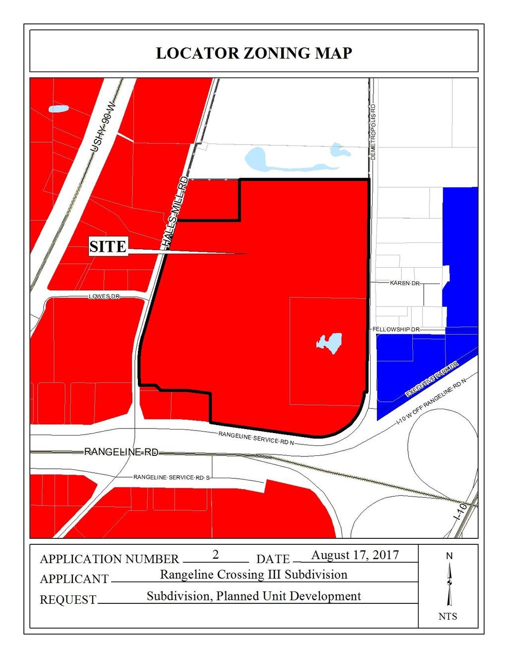
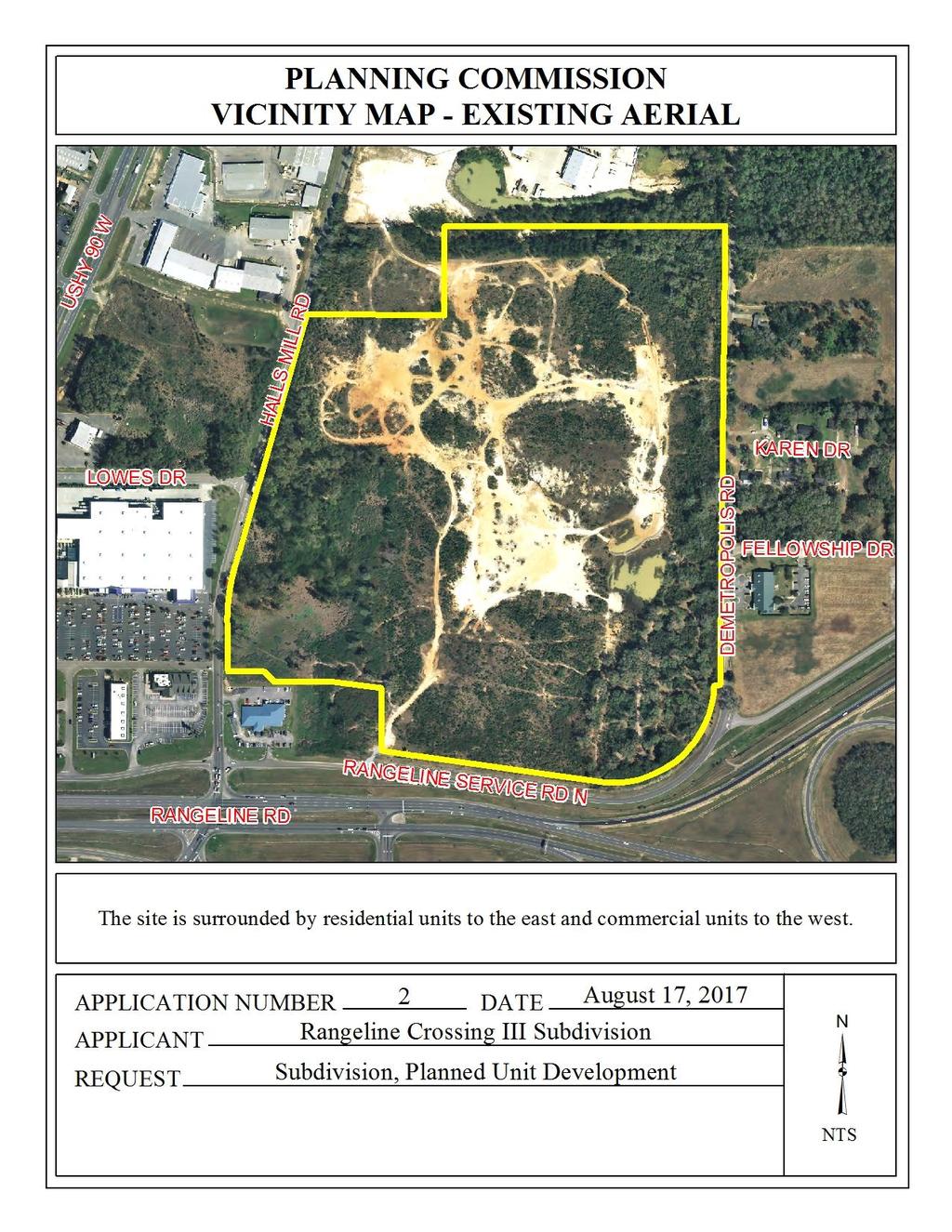
1 PLANNED UNIT DEVELOPMENT & SUBDIVISION STAFF REPORT Date: July 20, 2017 DEVELOPMENT NAME SUBDIVISION NAME LOCATION Rangeline Crossing III Subdivision Rangeline Crossing III Subdivision 5289 Halls Mill Road (North side of Rangeline Service Road, 280 ± East of Halls Mill Road, extending to the West side of Demetropolis Road) CITY COUNCIL DISTRICT District 4 AREA OF PROPERTY 5 Lots / 25.9 ± acres (Subdivision) 8 Lots / acres (PUD) CONTEMPLATED USE Planned Unit Development Approval to amend a previously approved Planned Unit Development to allow shared access between multiple lots, and Subdivision Approval to create 3 lots. TIME SCHEDULE FOR DEVELOPMENT None given. ENGINEERING COMMENTS Subdivision FINAL PLAT COMMENTS (should be addressed prior to submitting the FINAL PLAT for review and/or signature by the City Engineer): A. Provide all of the required information on the SUBDIVISION PLAT (i.e. signature blocks, signatures, certification statements, written legal description, required notes, legend, scale, bearings and distances) that is required by the current Alabama State Board of Licensure for Professional Engineers and Land Surveyors. B. Review and revise the written legal description to include the actual recording information for previous subdivision. C. Provide and label the monument set or found at each subdivision corner. D. Provide the Surveyor s, Owner s (notarized), Planning Commission, and Traffic Engineering signatures. E. Add a note to the SUBDIVISION PLAT stating that a Land Disturbance permit will be required for any land disturbing activity in accordance with Mobile City Code, Chapter 17, Storm Water Management and Flood Control); the City of Mobile, Alabama Flood Plain Management Plan (1984); and, the Rules For Erosion and Sedimentation Control and Storm Water Runoff Control.
2 F. Add a note to the Plat stating that the approval of all applicable federal, state, and local agencies (including all storm water runoff, wetland and floodplain requirements) will be required prior to the issuance of a Land Disturbance permit. G. Add a note that sidewalk is required to be constructed, and/or repaired, along the frontage of each lot, or parcel, at time of new development or construction, unless a sidewalk waiver is approved. H. Provide a copy of the FINAL SUBDIVISION PLAT to the Engineering Dept. for review. No signatures are required on this drawing. I. After addressing all of the FINAL SUBDIVISION PLAT review comments by the Engineering Dept. provide the ORIGINAL (with all other signatures) and one (1) copy (signatures not required) of the revised Final Plat to the Engineering Department. Revised for August 17 meeting: FINAL PLAT COMMENTS (should be addressed prior to submitting the FINAL PLAT for review and/or signature by the City Engineer): A. Provide all of the required information on the SUBDIVISION PLAT (i.e. signature blocks, signatures, certification statements, written legal description, required notes, legend, scale, bearings and distances) that is required by the current Alabama State Board of Licensure for Professional Engineers and Land Surveyors. B. Review and revise the written legal description to include the actual recording information for previous subdivision. C. Label Yogger Pass as Private ROW and recording information. Also label it as NOT INCLUDED for this plat. D. Provide the Surveyor s, Owner s (notarized), Planning Commission, and Traffic Engineering signatures. E. Provide a copy of the FINAL SUBDIVISION PLAT to the Engineering Dept. for review. No signatures are required on this drawing. F. After addressing all of the FINAL SUBDIVISION PLAT review comments by the Engineering Dept. provide the ORIGINAL (with all other signatures) and one (1) copy (signatures not required) of the revised Final Plat to the Engineering Department. Planned Unit Development DELETE PUD NOTES #1 AND #2 SINCE THEY CONFLICT WITH CITY COMPLIANCE NOTES #2 & #3 RENUMBER THE CITY COMPLIANCE NOTES #4 - #10 SO THAT THERE ARE NOT TWO (2) #4 NOTES. RETAIN THE FIVE (5) CITY COMPLIANCE NOTES #1 - #4 SHOWN ON THE PLANNED UNIT DEVELOPMENT III SITE PLAN : 1. Any work performed in the existing ROW (right-of-way) such as driveways, sidewalks, utility connections, grading, drainage, irrigation, or landscaping will require a ROW permit from the City of Mobile Engineering Department ( ) and must comply with the City of Mobile Right-of-Way Construction and Administration Ordinance (Mobile City Code, Chapter 57, Article VIII). 2. A Land Disturbance Permit application shall be submitted for any proposed land disturbing activity with the property. A complete set of construction plans including, but not limited to, - 2 -
3 drainage, utilities, grading, storm water detention systems, paving, and all above ground structures, will need to be included with the Land Disturbance permit. This Permit must be submitted, approved, and issued prior to beginning any of the construction work. 3. Any and all proposed land disturbing activity within the property will need to be submitted for review and be in conformance with Mobile City Code, Chapter 17, Storm Water Management and Flood Control); the City of Mobile, Alabama Flood Plain Management Plan (1984); and, the Rules For Erosion and Sedimentation Control and Storm Water Runoff Control. 4. The approval of all applicable federal, state, and local agencies (including all storm water runoff, wetland and floodplain requirements) will be required prior to the issuance of a Land Disturbance permit. The Owner/Developer is responsible for acquiring all of the necessary permits and approvals. 5. The proposed development must comply with all Engineering Department design requirements and Policy Letters. TRAFFIC ENGINEERING COMMENTS A traffic impact study was completed for this site. The study includes off-site improvements along Halls Mill Road adjacent to the development and southward to the intersection of Rangeline Road. Any improvements within the Service Road right-of-way or the Rangeline Road right-of-way are subject to ALDOT approval and permitting. Development is contingent upon the completion of off-site improvements as required by the City of Mobile and ALDOT. Additional impact studies or updates to this study will be required as the development changes or more proposed uses are presented to the City. Driveway number, size, location and design are subject to the approved PUD for this site, and shall be approved by ALDOT (where applicable) and Traffic Engineering and conform to AASHTO standards. Required on-site parking, including ADA handicap spaces, shall meet the minimum standards as defined in Section 64-6 of the City s Zoning Ordinance. The site address needs to be corrected on the submitted PUD site plan. The previously approved plat from the May 4 Planning Commission meeting will need to be recorded prior to recording the resubdivision that is currently being presented for approval. URBAN FORESTRY COMMENTS Property to be developed in compliance with state and local laws that pertain to tree preservation and protection on both city and private properties (State Act and City Code Chapters 57 and 64). FIRE DEPARTMENT COMMENTS All projects within the City Limits of Mobile shall comply with the requirements of the City of Mobile Fire Code Ordinance. (2012 International Fire Code) REMARKS The applicant is seeking Planned Unit Development Approval to amend a previously approved Planned Unit Development to allow shared access between multiple lots, and Subdivision Approval to create 3 lots from a previously approved Lot 3 from the Rangeline Crossing Subdivision. The site is located in Council District 4, and according to the applicant is served by public water and sanitary sewer
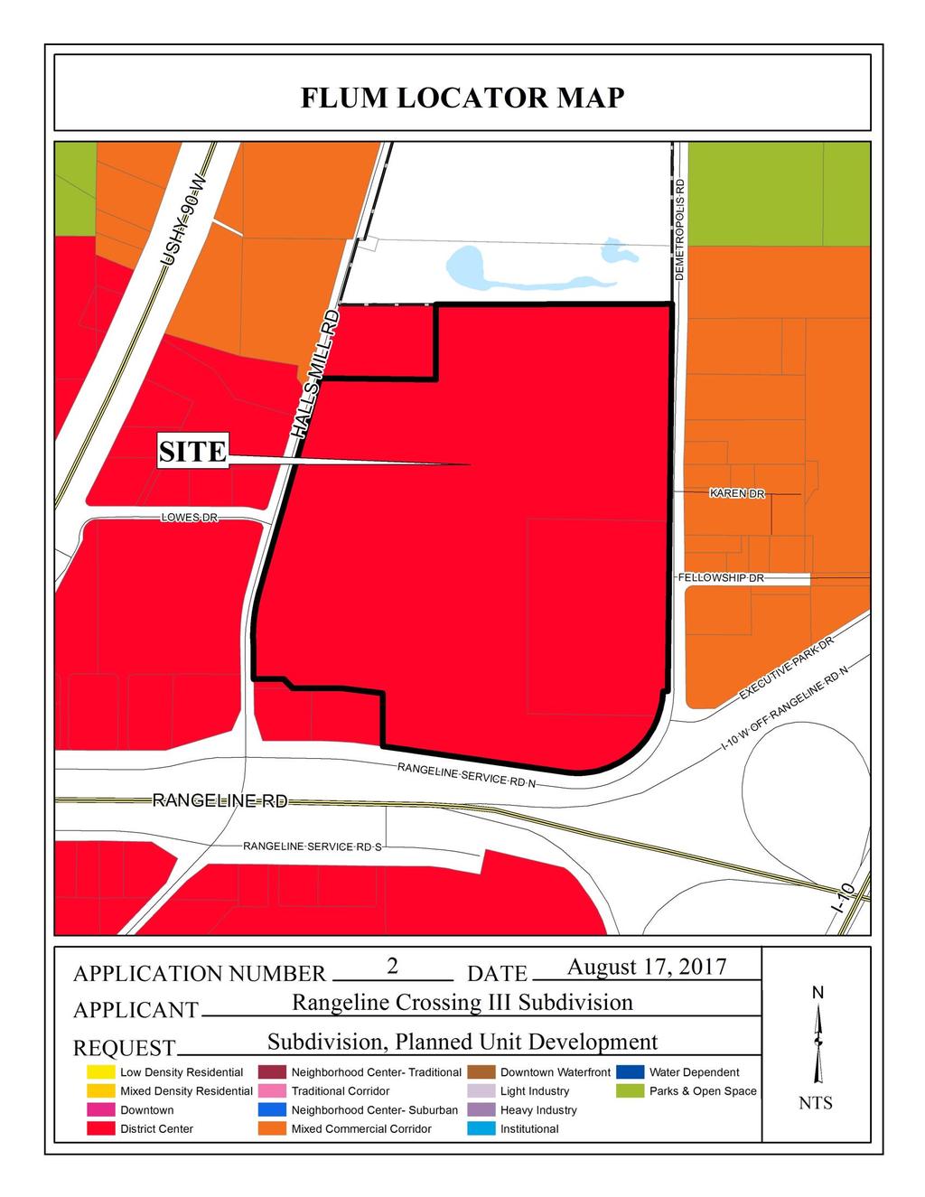
4 The site has been given a District Center land use designation, per the recently adopted Future Land Use Plan and Map. The Future Land Use Plan and Map complements and provides additional detail to the Development Framework Maps in the Map for Mobile, adopted by the Planning Commission at its November 5, 2015 meeting. This designation applies across the city to larger areas of existing mixed-use character or where such character is encouraged. These areas will include moderate to high-density residential (minimum densities of 6 du/ac) in dynamic, horizontal or vertical mixed use environments, to provide a balance of housing and employment. District Centers generally serve several surrounding neighborhoods and may even have a citywide or region-wide reach. As such, they are often anchored by a major commercial or institutional employer such as a shopping mall or a medical center. Depending on location and assigned zoning, residential areas in District Centers may incorporate a mix of housing types, ranging from mid-rise multifamily buildings containing apartments and lofts, to townhouses and detached single-family homes. Major civic cultural institutions and public spaces provide regional and neighborhood destinations. District Centers should be designed to induce pedestrian activity, with high quality streetscapes connecting the different components of a center as well as the center to its surrounding area. DC districts may be served by transit and include development of an intensity and design that supports transit use. It should be noted that the Future Land Use Plan and Map components of the Map for Mobile Plan are meant to serve as a general guide, not a detailed lot and district plan. In many cases the designation on the new Future Land Use Map may match the existing use of land, but in others the designated land use may differ from what is on the ground today. As such, the Future Land Use Plan and Map allows the Planning Commission and City Council to consider individual cases based on additional information such as the classification request, the surrounding development, the timing of the request, and the appropriateness and compatibility of the proposed use and, where applicable, the zoning classification. The purpose of this application, according to the applicant, is as follows: The contemplated use of Rangeline Crossing PUD is to allow for shared ingress and egress via private right-of-way. This PUD adds three more lots that were subdivided from one lot on the previous PUD. Planned Unit Development review examines the site with regard to its location to ensure that it is generally compatible with neighboring uses; that adequate access is provided without generating excess traffic along minor residential streets in residential districts outside the PUD; and that natural features of the site are taken into consideration. PUD review also examines the design of the development to provide for adequate circulation within the development; to ensure adequate access for emergency vehicles; and to consider and provide for protection from adverse effects of adjacent properties as well as provide protection of adjacent properties from adverse effects from the PUD. PUD approval is site plan specific, thus any changes to the site plan / Subdivision plat will require approval by the Planning Commission
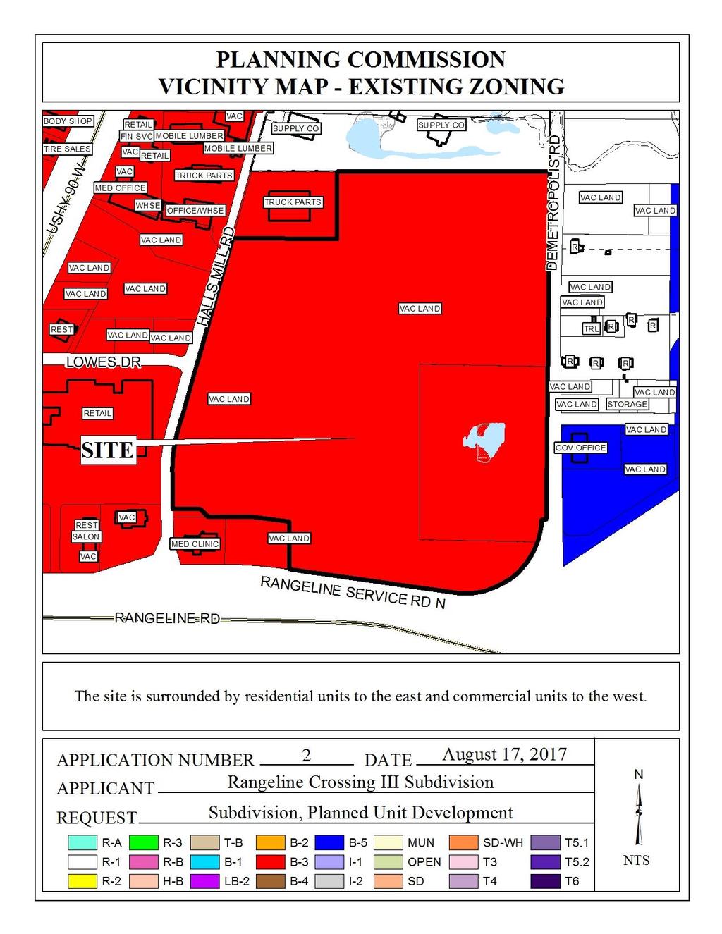
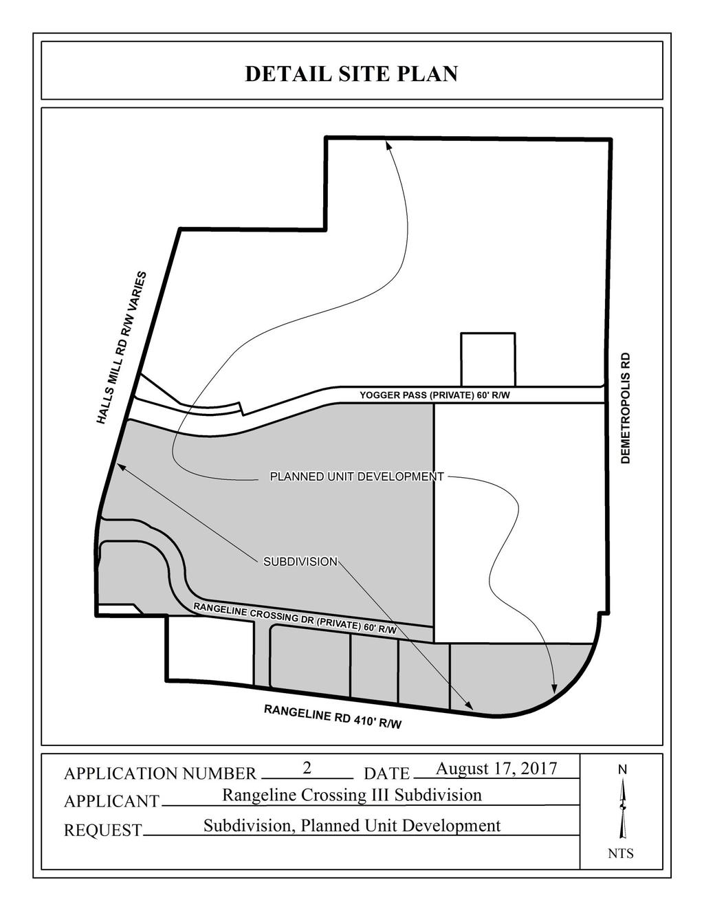
5 Please note that a Planned Unit Development approval by the Planning Commission expires after one year if no permits are obtained. Subdivision review examines the site with regard to promoting orderly development, protecting general health, safety and welfare, and ensuring that development is correlated with adjacent developments and public utilities and services, and to ensure that the subdivision meets the minimum standards set forth in the Subdivision Regulations for lot size, road frontage, lot configuration, etc. The site (or parts thereof), has been before the Planning Commission numerous times, most recently at the Commission s May 4 th and February 16, 2017 meetings, where Subdivision and Planned Unit Development approvals were granted. It should be noted that the plat from the most recent May 4 th approval has not been signed by City Departments or recorded in Mobile County Probate Court. The applications at hand are to subdivide lots approved at the May 4 th meeting. The site is zoned B-3, Community District, which allows a wide range of commercial and residential uses. The PUD will contain a total of seven lots, two large common areas, and several smaller common areas. The two larger common areas will be used for storm water detention for the overall development. A large medical clinic and a fast-food restaurant are currently proposed, both of which will access a proposed private street. A public street is also proposed as part of the overall development, and will link Halls Mill Road to Demetropolis Road. Because of the size of the overall PUD site and the proximity of the site to Rangeline Road, an ALDOT maintained facility, access management is a concern. The PUD site plan shows that the proposed fast-food lot will have one curb-cut to the Rangeline Service Road North, and two curb-cuts to the proposed private roads (Rangeline Crossing Drive) within the development. The proposed clinic is depicted as having two curb-cuts to Demetropolis Road and one curb-cut to the proposed private road. The clinic additionally abuts the proposed public street (Yogger Pass), and access to this street can be granted via one curb-cut once that street is built and accepted for maintenance by the City of Mobile; however, once access is obtained to Yogger Pass, the clinic's most northern access point to Demetropolis Road should be closed due to possible traffic conflicts. With the exception of future access by the clinic site to Yogger Pass, all other lots within the PUD should be limited in terms of the number of curb-cuts as depicted on an approved PUD site plan. The PUD site plan depicts Lot B as having a fast food restaurant developed on the site with compliant parking and queuing spaces; however the dumpster is located with the 25 minimum building setback line. The site plan should be revised to depict the relocation of the dumpster so that it is not located within the setbacks. The site plan should also be revised to include a note stating full tree planting and landscape requirements will be meet and in compliance with Section 64-4.E of the Zoning Ordinance. The 25 minimum building setback lines are depicted on the site plan and the plat and should be retained on any future site plans
6 Please note all proposed signage will require separate permits, reviews, and approvals. As for the Subdivision, all lots will meet the minimum size and area requirements for lots with access to public water and sewer. Several drainage, access and utility easements are depicted on the preliminary plat and the PUD site plan. A note should be placed on both the plat and the site plan stating that structures that are not associated with the purpose of the easement shall not be placed within any easement. Sidewalks are depicted on the site plan and should be retained on any future plans. It should be pointed out that the newly proposed PUD site plan does not reflect the previously approved site plan and plat in that the layout of the proposed private road (Rangeline Crossing Drive) has changed. The new proposed location of the private road depicts significant changes that effect Lots 1 and 2 of the Rangeline Crossing Subdivision approved on May 4 th. As such, the previous approved plat must be revised to reflect the new location of the proposed private road. Therefore the current applications must be heldover to allow a revised application to be submitted for subdivision approval to allow consistency among the plats and site plans. RECOMMENDATION Subdivision: Based upon the preceding, this application is recommended for Holdover until the August 17 meeting, with revisions due by Tuesday August 1, 2017 to be heard in conjunction with the associated Planned Unit Development. Additional lot, postage, and notification fees will be required, in addition to a revised plat and narrative. Planned Unit Development: Based upon the preceding, this application is recommended for Holdover until the August 17, 2017 meeting, with revisions due by Tuesday August 1, 2017 to address the following: 1. submission of a revised subdivision application to address the new location of the proposed private road and the resulting changes to Lots 1 and revision of the site plan to remove the dumpster outside of the 25 minimum building setbacks; 3. add a note to the site plan stating full tree planting and landscape requirements will be met and in compliance with Section 64-4.E of the Zoning Ordinance; and 4. add a note to both the plat and the site plan stating that structures that are not associated with the purpose of the easement shall not be placed within any easement. Revised for August 17 th meeting The applications were heldover from the July 20 th meeting to allow the applicant to address the following: submission of a revised subdivision application to address the new location of the proposed private street and the resulting changes to Lots 1 and 2, a revised site plan removing the dumpster out of the 25 minimum building setbacks, adding a note to the site plan stating full tree planting and landscape requirements will be met and in compliance with Section 64-4.E of the Zoning Ordinance, and by adding a note to both the plat and the site plan stating that - 6 -
7 structures that are not associated with the purpose of the easement shall not be placed within any easement. Based on the revised site plans it does appear that the applicant has addressed all of the previous conditions for the PUD. The applicant has also satisfied the subdivision condition by providing additional labels and fees. As revised, the Subdivision plat depicts 5 proposed lots, ranging from 1 ± acres to 18 ± acres in size, and a 2.7 ± acre common area detention facility. The changes to Lots 1 and 2 are to accommodate the realignment of the proposed Rangeline Crossing Drive (private street), moving its intersection with Halls Mill Road approximately 150 further from the Rangeline Road/ Halls Mill Road intersection. As no proposed development is depicted on the PUD site plan for Lots 1-5, staff cannot determine the appropriate number of curb-cuts for each lot. Thus a note should be placed on the Final Plat stating that the number, size, design and location of curb-cuts is subject to a Planning Commission approved Planned Unit Development. Subdivision: Based upon the preceding the application is recommended for Tentative Approval, subject to the following conditions: 1) retention of lot sizes in square feet and acres; 2) retention of the 25 minimum building setback lines along where the property lines abut road frontage; 3) placement of a note on the Final Plat stating the number, size, design and location of curb-cuts is subject to a Planning Commission approved Planned Unit Development; 4) placement of a note on the Final Plat stating that structures that are not associated with the purpose of the easement shall not be placed within any easement; 5) compliance with Engineering comments: FINAL PLAT COMMENTS (should be addressed prior to submitting the FINAL PLAT for review and/or signature by the City Engineer): A. Provide all of the required information on the SUBDIVISION PLAT (i.e. signature blocks, signatures, certification statements, written legal description, required notes, legend, scale, bearings and distances) that is required by the current Alabama State Board of Licensure for Professional Engineers and Land Surveyors. B. Review and revise the written legal description to include the actual recording information for previous subdivision. C. Label Yogger Pass as Private ROW and recording information. Also label it as NOT INCLUDED for this plat. D. Provide the Surveyor s, Owner s (notarized), Planning Commission, and Traffic Engineering signatures. E. Provide a copy of the FINAL SUBDIVISION PLAT to the Engineering Dept. for review. No signatures are required on this drawing. F. After addressing all of the FINAL SUBDIVISION PLAT review comments by the Engineering Dept. provide the ORIGINAL (with all other signatures) and one (1) copy (signatures not required) of the revised Final Plat to the Engineering Department. ; 6) compliance with Traffic Engineering comments: A traffic impact study was completed for this site. The study includes off-site improvements along Halls Mill Road adjacent to the development and southward to the intersection of Rangeline Road. Any improvements within the Service Road right-of-way or the Rangeline Road right-of-way are subject to ALDOT approval and permitting. Development is contingent upon the completion of off-site improvements as required by the City of Mobile and ALDOT. Additional impact studies or updates to this study will be required as the development - 7 -
8 changes or more proposed uses are presented to the City. Driveway number, size, location and design are subject to the approved PUD for this site, and shall be approved by ALDOT (where applicable) and Traffic Engineering and conform to AASHTO standards. Required on-site parking, including ADA handicap spaces, shall meet the minimum standards as defined in Section 64-6 of the City s Zoning Ordinance. The site address needs to be corrected on the submitted PUD site plan. The previously approved plat from the May 4 Planning Commission meeting will need to be recorded prior to recording the resubdivision that is currently being presented for approval. ; 7) compliance with Urban Forestry comments: Property to be developed in compliance with state and local laws that pertain to tree preservation and protection on both city and private properties (State Act and City Code Chapters 57 and 64). ; 8) compliance with Fire comments: All projects within the City Limits of Mobile shall comply with the requirements of the City of Mobile Fire Code Ordinance. (2012 International Fire Code) ;and 9) completion of the PUD process prior to the signing of the Final Plat. Planned Unit Development: Based upon the preceding, this application is recommended for Approval, subject to the following conditions: 1) retention of lot sizes in square feet and acres; 2) retention of the 25 minimum building setback lines along where the property lines abut road frontage; 3) retention of the note on the site plan stating full tree planting and landscape requirements will be met and in compliance with Section 64-4.E of the Zoning Ordinance; 4) placement of a note on the site plan stating that structures that are not associated with the purpose of the easement shall not be placed within any easement; 5) compliance with Engineering comments: DELETE PUD NOTES #1 AND #2 SINCE THEY CONFLICT WITH CITY COMPLIANCE NOTES #2 & #3. RENUMBER THE CITY COMPLIANCE NOTES #4 - #10 SO THAT THERE ARE NOT TWO (2) #4 NOTES. RETAIN THE FIVE (5) CITY COMPLIANCE NOTES #1 - #4 SHOWN ON THE PLANNED UNIT DEVELOPMENT III SITE PLAN : 1. Any work performed in the existing ROW (right-ofway) such as driveways, sidewalks, utility connections, grading, drainage, irrigation, or landscaping will require a ROW permit from the City of Mobile Engineering Department ( ) and must comply with the City of Mobile Right-of-Way Construction and Administration Ordinance (Mobile City Code, Chapter 57, Article VIII). 2. A Land Disturbance Permit application shall be submitted for any proposed land disturbing activity with the property. A complete set of construction plans including, but not limited to, drainage, utilities, grading, storm water detention systems, paving, and all above ground structures, will need to be included with the Land Disturbance permit. This Permit must be submitted, approved, and issued prior to beginning any of the construction work. 3. Any and all proposed land disturbing activity within the property will need to be submitted for review and be in conformance with Mobile City Code, Chapter 17, Storm Water Management and Flood Control); the City of Mobile, Alabama Flood Plain Management Plan (1984); and, the Rules For Erosion and Sedimentation Control and Storm Water Runoff Control. 4. The approval of all applicable federal, state, and local agencies (including all storm water runoff, wetland and floodplain requirements) will be required prior to the issuance of a Land Disturbance permit. The Owner/Developer is responsible for acquiring all of the necessary - 8 -
9 permits and approvals. 5. The proposed development must comply with all Engineering Department design requirements and Policy Letters. ; 6) compliance with Traffic Engineering comments: A traffic impact study was completed for this site. The study includes off-site improvements along Halls Mill Road adjacent to the development and southward to the intersection of Rangeline Road. Any improvements within the Service Road right-of-way or the Rangeline Road right-of-way are subject to ALDOT approval and permitting. Development is contingent upon the completion of off-site improvements as required by the City of Mobile and ALDOT. Additional impact studies or updates to this study will be required as the development changes or more proposed uses are presented to the City. Driveway number, size, location and design are subject to the approved PUD for this site, and shall be approved by ALDOT (where applicable) and Traffic Engineering and conform to AASHTO standards. Required on-site parking, including ADA handicap spaces, shall meet the minimum standards as defined in Section 64-6 of the City s Zoning Ordinance. The site address needs to be corrected on the submitted PUD site plan. The previously approved plat from the May 4 Planning Commission meeting will need to be recorded prior to recording the resubdivision that is currently being presented for approval. ; 7) compliance with Urban Forestry comments: Property to be developed in compliance with state and local laws that pertain to tree preservation and protection on both city and private properties (State Act and City Code Chapters 57 and 64). ; 8) compliance with Fire comments: All projects within the City Limits of Mobile shall comply with the requirements of the City of Mobile Fire Code Ordinance. (2012 International Fire Code) ; 9) submission of a revised PUD site plan prior to the signing of the Final Plat. 10) provision of two revised PUD copies of the site plan for the Planning and Zoning Department; and 11) compliance with all other municipal codes and ordinances
10 - 10 -
11 - 11 -
12 - 12 -
13 - 13 -
14 - 14 -
15 - 15 -
16 - 16 -
17 - 17 -
18 - 18 -
WESTMINSTER PARK PLACE SUBDIVISION
 WESTMINSTER PARK PLACE SUBDIVISION Engineering Comments: FINAL PLAT COMMENTS (should be addressed prior to submitting the FINAL PLAT for review and/or signature by the City Engineer): A. Provide all of
WESTMINSTER PARK SUBDIVISION
 WESTMINSTER PARK SUBDIVISION Engineering Comments: FINAL PLAT COMMENTS (should be addressed prior to submitting the FINAL PLAT for review and/or signature by the City Engineer): A. Provide all of the required
PLANNED UNIT DEVELOPMENT & SUBDIVISION STAFF REPORT Date: September 15, 2016
 # 10 SUB2016-00089 PLANNED UNIT DEVELOPMENT & SUBDIVISION STAFF REPORT Date: September 15, 2016 NAME SUBDIVISION NAME LOCATION Lot 12 Laughlin Industrial Park Subdivision Lot 12 Laughlin Industrial Park
PLANNED UNIT DEVELOPMENT & SUBDIVISION STAFF REPORT August 18, 2016
 PLANNED UNIT DEVELOPMENT & SUBDIVISION STAFF REPORT August 18, 2016 DEVELOPMENT NAME SUBDIVISION NAME Mullinax Ford Subdivision Mullinax Ford Subdivision LOCATION CITY COUNCIL DISTRICT District 6 Southeast
ZONING AMENDMENT, PLANNED UNIT DEVELOPMENT & SUBDIVISION STAFF REPORT Date: August 8, 2013
 ZONING AMENDMENT, PLANNED UNIT DEVELOPMENT & SUBDIVISION STAFF REPORT Date: August 8, 2013 NAME SUBDIVISION NAME PV-Magnolia, LLC Twelve Trees Subdivision LOCATION 2860, 2862 and 2866 Pleasant Valley Road
THE WHEELER BUILDING SUBDIVISION
 THE WHEELER BUILDING SUBDIVISION Engineering Comments: FINAL PLAT COMMENTS (should be addressed prior to submitting the FINAL PLAT for review and/or signature by the City Engineer): A. Provide all of the
PLANNED UNIT DEVELOPMENT & SUBDIVISION STAFF REPORT Date: November 17, 2016
 PLANNED UNIT DEVELOPMENT & SUBDIVISION STAFF REPORT Date: November 17, 2016 DEVELOPMENT NAME SUBDIVISION NAME LOCATION Autonation Ford of Mobile Autonation Ford of Mobile Subdivision 901, 909, and 925
ZONING AMENDMENT & SUBDIVISION STAFF REPORT Date: March 1, 2018
 #13 SUB-000406-2018 & ZON-000407-2018 ZONING AMENDMENT & SUBDIVISION STAFF REPORT Date: March 1, 2018 NAME SUBDIVISION NAME LOCATION Creekside @ Kooiman Dairy Creekside @ Kooiman Dairy Subdivision (South
SUBDIVISION & PLANNING APPROVAL STAFF REPORT Date: December 1, 2016
 SUBDIVISION & PLANNING APPROVAL STAFF REPORT Date: December 1, 2016 APPLICANT NAME SUBDIVISION NAME DEVELOPMENT NAME LOCATION Board of Water and Sewer Commissioners of the City of Mobile Halls Mill Road
ZONING AMENDMENT & SUBDIVISION STAFF REPORT Date: November 3, 2016
 ZONING AMENDMENT & SUBDIVISION STAFF REPORT Date: November 3, 2016 APPLICANT NAME SUBDIVISION NAME David Shumer 5955 Airport Subdivision CITY COUNCIL DISTRICT District 6 5955 Airport Boulevard, 754 Linlen
SUBDIVISION, PLANNED UNIT DEVELOPMENT, ZONING AMENDMENT, & SIDEWALK WAIVER STAFF REPORT Date: July 19, 2018
 SUBDIVISION, PLANNED UNIT DEVELOPMENT, ZONING AMENDMENT, & SIDEWALK WAIVER STAFF REPORT Date: July 19, 2018 NAME SUBDIVISION NAME LOCATION West Mobile Properties, LLC U.S. Machine Subdivision 556, 566,
HAWTHORNE PLACE SUBDIVISON, RESUBDIVISION OF LOT 15 REVISED
 # 10 SUB-000336-2017 HAWTHORNE PLACE SUBDIVISON, RESUBDIVISION OF LOT 15 REVISED Engineering Comments: FINAL PLAT COMMENTS (should be addressed prior to submitting the FINAL PLAT for review and/or signature
BROADWAY THREE NOTCH ROAD SUBDIVISION
 # 3 SUB-000803-2018 BROADWAY THREE NOTCH ROAD SUBDIVISION Engineering Comments: FINAL PLAT COMMENTS (should be addressed prior to submitting the FINAL PLAT for review and/or signature by the City Engineer):
PLANNED UNIT DEVELOPMENT & SUBDIVISION STAFF REPORT Date: April 18, 2019
 PLANNED UNIT DEVELOPMENT & SUBDIVISION STAFF REPORT Date: April 18, 2019 DEVELOPMENT NAME SUBDIVISION NAME Springhill Village Subdivision Springhill Village Subdivision LOCATION 4350, 4354, 4356, 4358,
SUBDIVISION, PLANNED UNIT DEVELOPMENT, & REZONING STAFF REPORT Date: September 17, 2015
 SUBDIVISION, PLANNED UNIT DEVELOPMENT, & REZONING STAFF REPORT Date: September 17, 2015 APPLICANT NAME SUBDIVISION NAME DEVELOPMENT NAME LOCATION Daniel Clark Mack Manufacturing Subdivision, Resubdivision
THE CI FY OF MOBILE, ALABAMA
 THE CI FY OF MOBILE, ALABAMA LETTER OF DECISION DewberryiPreble-Rish 9949 Bellaton Avenue Daphne, AL 36526 Re: Area bounded by Foxtail Drive, Lace Bark Drive and Whitebark Drive Council District 6 SUB-000323-2017
ALBA BEACH SUBDIVISION, RESUBDIVISION OF LOT 17
 ALBA BEACH SUBDIVISION, RESUBDIVISION OF LOT 17 Engineering Comments: FINAL PLAT COMMENTS (should be addressed prior to submitting the FINAL PLAT for acceptance and signature by the City Engineer): A.
PLANNED UNIT DEVELOPMENT & ZONING AMENDMENT STAFF REPORT Date: December 21, 2017
 # 14 PUD-000324-2017 & ZON-000326-2017 PLANNED UNIT DEVELOPMENT & ZONING AMENDMENT STAFF REPORT Date: December 21, 2017 APPLICANT NAME DEVELOPMENT NAME LOCATION Dewberry/Preble-Rish Longleaf Gates Subdivision,
MOBILE TOWERS SUBDIVISION
 # 3 SUB2014-00100 MOBILE TOWERS SUBDIVISION Engineering Comments: The following comments should be addressed prior to submitting the FINAL PLAT for acceptance and signature by the City Engineer: 1) Provide
ZONING AMENDMENT & SUBDIVISION STAFF REPORT Date: July 9, 2015
 ZONING AMENDMENT & SUBDIVISION STAFF REPORT Date: July 9, 2015 APPLICANT NAME 2513 Dauphin Street, Inc. SUBDIVISION NAME Audubon Place Extension No. 3, Resubdivision of Lots 1-5 LOCATION 2513 Dauphin Street
TULSA PARK ESTATES SUBDIVISION, RESUBDIVISION OF LOT 6
 TULSA PARK ESTATES SUBDIVISION, RESUBDIVISION OF LOT 6 Engineering Comments: FINAL PLAT COMMENTS (should be addressed prior to submitting the FINAL PLAT for review and/or signature by the City Engineer):
JOHNNY S RV PARK SUBDIVISION
 # 11 SUB2016-00001 JOHNNY S RV PARK SUBDIVISION Engineering Comments: The following comments should be addressed prior to submitting the FINAL PLAT for acceptance and signature by the City Engineer: A.
DAUPHIN CREEK ESTATES SUBDIVISION
 # 12 SUB-000076-2017 DAUPHIN CREEK ESTATES SUBDIVISION Engineering Comments: FINAL PLAT COMMENTS (should be addressed prior to submitting the FINAL PLAT for review and/or signature by the City Engineer):
THE CITY OF MOBILE, ALABAMA
 THE CITY OF MOBILE, ALABAMA LETTER OF DECISION March 9, 2018 Byrd Surveying, Inc. 2609 Halls Mill Road Mobile, AL 36606 Re: 4439 Rangeline Road (Northwest corner of Rangeline Road and Halls Mill Road).
SUBDIVISION, PLANNING APPROVAL, & REZONING STAFF REPORT Date: June 4, 2015
 SUBDIVISION, PLANNING APPROVAL, & REZONING STAFF REPORT Date: June 4, 2015 APPLICANT NAME SUBDIVISION NAME DEVELOPMENT NAME LOCATION Board of Water & Sewer Commissioners of the City of Mobile MAWSS MLK
ZONING AMENDMENT & SUBDIVISION STAFF REPORT Date: June 18, 2015
 ZONING AMENDMENT & SUBDIVISION STAFF REPORT Date: June 18, 2015 APPLICANT NAME SUBDIVISION NAME EAA LLC / Eryka Rogers Aaiden Place Subdivision LOCATION 2480 Government Boulevard (North side of Government
MCGOWIN PARK EAST OF SATCHEL PAIGE SUBDIVISION, RESUBDIVISION OF
 # 14 SUB2015-00058 MCGOWIN PARK EAST OF SATCHEL PAIGE SUBDIVISION, RESUBDIVISION OF Engineering Comments: The following comments should be addressed prior to submitting the FINAL PLAT for acceptance and
ZONING AMENDMENT & SUBDIVISION STAFF REPORT Date: July 3, 2014
 ZONING AMENDMENT & SUBDIVISION STAFF REPORT Date: July 3, 2014 APPLICANT NAME SUBDIVISION NAME LOCATION Georgia Crown Distributing Subdivision Georgia Crown Distributing Subdivision Southwest corner of
PLANNED UNIT DEVELOPMENT STAFF REPORT Date: October 19, 2017
 PLANNED UNIT DEVELOPMENT STAFF REPORT Date: October 19, 2017 DEVELOPMENT NAME LOCATION Custom Boat Storage 3975 Demetropolis Road (East side of Demetropolis Road, 0.2± miles South of Halls Mill Road.)
DINKINS ESTATE FAMILY SUBDIVISION
 # 9 SUB2015-00122 DINKINS ESTATE FAMILY SUBDIVISION Engineering Comments: The following comments should be addressed prior to submitting the FINAL PLAT for acceptance and signature by the City Engineer:
PLANNED UNIT DEVELOPMENT, SIDEWALK WAIVER, & SUBDIVISION STAFF REPORT Date: November 6, 2008
 PLANNED UNIT DEVELOPMENT, SIDEWALK WAIVER, & SUBDIVISION STAFF REPORT Date: November 6, 2008 DEVELOPMENT NAME SUBDIVISION NAME LOCATION Frascati Shops, Inc. Frascati Subdivision 1120 Paper Mill Road CITY
MTC ALABAMA SUBDIVISION
 # 2 SUB-000370-2017 MTC ALABAMA SUBDIVISION Engineering Comments: FINAL PLAT COMMENTS (should be addressed prior to submitting the FINAL PLAT for review and/or signature by the City Engineer): A. Provide
THE CITY OF MOBILE, ALABAMA
 THE CITY OF MOBILE, ALABAMA LE 'I IER OF DECISION Kimberly Clark Mobile Operations 200 Africatown Blvd. Prichard, AL 36610 Re: 100 & 200 Africatown Boulevard (Northeast corner of Bay Bridge Road and Paper
McGowin Park, LLC. B-3, Community Business District
 # 10, 11, 12 SUB2014-00024 ZON2014-00500 ZON2014-00501 SUBDIVISION, PLANNED UNIT DEVELOPMENT (East), PLANNED UNIT DEVELOPMENT (West) STAFF REPORT Date: April 3, 2014 DEVELOPMENT NAME LOCATION McGowin Park,
THE CITY OF MOBILE, ALABAMA
 THE CITY OF MOBILE, ALABAMA LETTER OF DECISION Dominion Senior Living of West Mobile, LLC 1200 Corporate Dr., St. 225 Birmingham, AL 35242 Re: 6924 Somerbv Lane (North terminus of Somerby Lane). Council
THE CITY OF MOBILE, ALABAMA MOBILE Crry PLANNING COMMISSION
 THE CITY OF MOBILE, ALABAMA MOBILE Crry PLANNING COMMISSION LETTER OF DECISION MLK Avenue Redevelopment Corp. Attn: Michael Pierce P.O. Box 2204 Mobile, AL 36652 Re: Case #SUB2014-00040 (Subdivision) MLK
THE CITY OF MOBILE, ALABAMA
 THE CITY OF MOBILE, ALABAMA LETTER OF DECISION Dewberry I Preble-Rish 9949 Bellaton Avenue Daphne, AL 36526 Re: 6050 & 6086 Whitebark Drive (North side of Girby Road, 125'± East of Bristlecone Drive, extending
ZONING AMENDMENT & PLANNED UNIT DEVELOPMENT STAFF REPORT Date: July 5, 2012
 ZONING AMENDMENT & PLANNED UNIT DEVELOPMENT STAFF REPORT Date: July 5, 2012 NAME DEVELOPMENT NAME LOCATION Mayo Blackmon Mayo Blackmon 1446 Navco Road & 2452 McLaughlin Drive. (North side of McLaughlin
PLANNED UNIT DEVELOPMENT & SUBDIVISION STAFF REPORT Date: March 15, 2007
 PLANNED UNIT DEVELOPMENT & SUBDIVISION STAFF REPORT Date: March 15, 2007 DEVELOPMENT NAME SUBDIVISION NAME LOCATION Motormax Subdivision Motormax Subdivision 2917 and 2929 Government Boulevard (South side
APPLICANT NAME SUBDIVISION NAME DEVELOPMENT NAME LOCATION. CITY COUNCIL DISTRICT Council District 4 PRESENT ZONING PROPOSED ZONING
 SUBDIVISION, PLANNED UNIT DEVELOPMENT, PLANNING APPROVAL, ZONING AMENDMENT, & SIDEWALK WAIVER REQUEST STAFF REPORT Date: February 17, 2010 APPLICANT NAME SUBDIVISION NAME DEVELOPMENT NAME LOCATION David
SUBDIVISION, PLANNED UNIT DEVELOPMENT, & REZONING STAFF REPORT Date: March 23, 2017
 SUBDIVISION, PLANNED UNIT DEVELOPMENT, & REZONING STAFF REPORT Date: March 23, 2017 APPLICANT NAME SUBDIVISION NAME DEVELOPMENT NAME LOCATION Sarah & Michael Stashak Old Shell at Ashland Place Subdivision
ZONING AMENDMENT & PLANNED UNIT DEVELOPMENT STAFF REPORT Date: June 7, 2012
 ZONING AMENDMENT & PLANNED UNIT DEVELOPMENT STAFF REPORT Date: June 7, 2012 NAME DEVELOPMENT NAME LOCATION Mayo Blackmon Mayo Blackmon 1446 Navco Road & 2452 McLaughlin Drive. (North side of McLaughlin
AMENDMENT TO REGULATING PLAN & SUBDIVISION STAFF REPORT Date: December 15, 2016
 AMENDMENT TO REGULATING PLAN & SUBDIVISION STAFF REPORT Date: December 15, 2016 NAME SUBDIVISION NAME Gulf States Engineering- Mathew C. Roberts, PLS Precision Engineering Subdivision LOCATION CITY COUNCIL
ZONING AMENDMENT & SUBDIVISION STAFF REPORT Date: March 7, 2013
 # 4 & 5 SUB2012-00141 & ZON2012-03157 HOLDOVER ZONING AMENDMENT & SUBDIVISION STAFF REPORT Date: March 7, 2013 APPLICANT NAME SUBDIVISION NAME LOCATION Garrard Development Services, LLC Michigan & Bay
SUBDIVISION, PLANNED UNIT DEVELOPMENT, PLANNING APPROVAL, ZONING AMENDMENT, & SIDEWALK WAIVER REQUEST STAFF REPORT Date: February 17, 2010
 SUBDIVISION, PLANNED UNIT DEVELOPMENT, PLANNING APPROVAL, ZONING AMENDMENT, & SIDEWALK WAIVER REQUEST STAFF REPORT Date: February 17, 2010 APPLICANT NAME SUBDIVISION NAME DEVELOPMENT NAME LOCATION David
ZONING AMENDMENT, PLANNED UNIT DEVELOPMENT & SUBDIVISION STAFF REPORT Date: September 15, 2011
 ZONING AMENDMENT, PLANNED UNIT DEVELOPMENT & SUBDIVISION STAFF REPORT Date: September 15, 2011 NAME SUBDIVISION NAME LOCATION Stratford, L.L.C. Grelot Office Park Subdivision North side of Grelot Road,
SUBDIVISION, PLANNED UNIT DEVELOPMENT, & PLANNING APPROVAL STAFF REPORT Date: February 1, 2007
 SUBDIVISION, PLANNED UNIT DEVELOPMENT, & PLANNING APPROVAL STAFF REPORT Date: February 1, 2007 DEVELOPMENT NAME SUBDIVISION NAME Pala Verde Mobile Home Park Subdivision Pala Verde Mobile Home Park Subdivision
SOUTHERN INDUSTRIAL PARK SUBDIVISION, LOT A, RESUBDIVISION OF LOTS 7 & 8
 SOUTHERN INDUSTRIAL PARK SUBDIVISION, LOT A, RESUBDIVISION OF LOTS 7 & 8 Engineering Comments: Need to increase width of existing easement to include an area at least 20 from the top of the existing ditch,
HERON LANDING SUBDIVISION
 HERON LANDING SUBDIVISION Engineering Comments: Per FEMA guidelines, any development greater than 5 acres in size or subdivision 50 lots in size, requires a flood study. Width of drainage easement to be
DEER RIVER COMMERCIAL PARK SUBDIVISION
 DEER RIVER COMMERCIAL PARK SUBDIVISION Engineering Comments: Must comply with the Mobile County Flood Damage Prevention Ordinance. Development shall be designed to comply with the storm water detention
ZONING AMENDMENT, PLANNED UNIT DEVELOPMENT & SUBDIVISION STAFF REPORT Date: March 5, 2009
 ZONING AMENDMENT, PLANNED UNIT DEVELOPMENT & SUBDIVISION STAFF REPORT Date: March 5, 2009 NAME SUBDIVISION NAME LOCATION Kentress Morrisette Booker T. Washington Highlands Subdivision, First Addition,
COCHRAN FAMILY RIVERSIDE ESTATE SUBDIVISION
 # 19 SUB2012-00111 COCHRAN FAMILY RIVERSIDE ESTATE SUBDIVISION Engineering Comments: The following comments should be addressed prior to review, acceptance and signature by the City Engineer: 1. Label/show
PLANNED UNIT DEVELOPMENT & SUBDIVISION STAFF REPORT Date: May 6, 2004
 # 3. & 4. File # ZON2004-00967 & SUB2004-00085 PLANNED UNIT DEVELOPMENT & SUBDIVISION STAFF REPORT Date: May 6, 2004 DEVELOPMENT NAME SUBDIVISION NAME Heron Lakes Subdivision, Phase One, Revised Lot 32
ZONING AMENDMENT STAFF REPORT Date: September 15, 2016
 ZONING AMENDMENT STAFF REPORT Date: September 15, 2016 NAME LOCATION Clear Water, LLC 3490 Hurricane Bay Road (Northeast corner of Hurricane Bay Road and Hurricane Bay Lane) CITY COUNCIL DISTRICT District
BAY FOREST PARK SUBDIVISION, RESUBDIVISION OF LOTS 6 & 7 AND BAY FOREST PARK SUBDIVISION LOT 10, OF THE RESUBDIVISON OF LOTS 9 & 10
 BAY FOREST PARK SUBDIVISION, RESUBDIVISION OF LOTS 6 & 7 AND BAY FOREST PARK SUBDIVISION LOT 10, OF THE RESUBDIVISON OF LOTS 9 & 10 Engineering Comments: Must comply with the Mobile County Flood Damage
PLANNED UNIT DEVELOPMENT STAFF REPORT Date: August 20, 2015
 # 3 HOLDOVER Revised ZON2015-01733 PLANNED UNIT DEVELOPMENT STAFF REPORT Date: August 20, 2015 DEVELOPMENT NAME LOCATION Joseph N. Asarisi, P.E. North side of Airport Boulevard 212 ± West of Mckeena Court.
KLUGE PLACE SUBDIVISION
 KLUGE PLACE SUBDIVISION Engineering Comments: Must comply with the Mobile County Flood Damage Prevention Ordinance. Development shall be designed to comply with the storm water detention and drainage facility
PLANNED UNIT DEVELOPMENT (East), PLANNED UNIT DEVELOPMENT (West) STAFF REPORT Date: September 18, 2014
, PLANNED UNIT DEVELOPMENT (West) STAFF REPORT Date: September 18, 2014") PLANNED UNIT DEVELOPMENT (East), PLANNED UNIT DEVELOPMENT (West) STAFF REPORT Date: September 18, 2014 DEVELOPMENT NAME LOCATION McGowin Park, LLC PLANNED UNIT DEVELOPMENT (East) 1401 Satchel Paige Drive
PLANNED UNIT DEVELOPMENT (East), PLANNED UNIT DEVELOPMENT (West) STAFF REPORT Date: September 18, 2014 DEVELOPMENT NAME LOCATION McGowin Park, LLC PLANNED UNIT DEVELOPMENT (East) 1401 Satchel Paige Drive
AMELIA LAKE SUBDIVISON, PHASES 1-2
 # 1 HOLDOVER Revised SUB2014-00089 AMELIA LAKE SUBDIVISON, PHASES 1-2 Engineering Comments: Must comply with the Mobile County Flood Damage Prevention Ordinance. Development shall be designed to comply
KRONER S MOBILE WEST COMMERCIAL BUSINESS PARK SUBDIVISION
 KRONER S MOBILE WEST COMMERCIAL BUSINESS PARK SUBDIVISION Engineering Comments: Must comply with the Mobile County Flood Damage Prevention Ordinance. Development shall be designed to comply with the storm
BETTA STOR-IT SUBDIVISION
 BETTA STOR-IT SUBDIVISION Engineering Comments: Must comply with all storm water and flood control ordinances. Any increase in impervious area in excess of 4,000 square feet will require detention. Any
AUTUMNDALE SUBDIVISION, RESUBDIVISION OF LOTS
 AUTUMNDALE SUBDIVISION, RESUBDIVISION OF LOTS 100-102 Engineering Comments: Road shall be constructed per City standards and according to the City s street acceptance process. Cul-de sac approval subject
DAWES SWITCHING STATION SUBDIVISION
 DAWES SWITCHING STATION SUBDIVISION Engineering Comments: Must comply with the Mobile County Flood Damage Prevention Ordinance. Development shall be designed to comply with the storm water detention and
ZONING AMENDMENT, PLANNED UNIT DEVELOPMENT & PLANNING APPROVAL STAFF REPORT Date: June 7, 2007
 ZONING AMENDMENT, PLANNED UNIT DEVELOPMENT & PLANNING APPROVAL STAFF REPORT Date: June 7, 2007 NAME LOCATION Johnny Randall Cotton and Angela K. Cotton 4800 Tufts Road (West side of Tufts Road, 50 ± North
STONE HEDGE SUBDIVISION, UNIT 1, RESUBDIVISION OF LOT 40 & WEST COMMON AREA
 # 5 SUB-000498-2018 STONE HEDGE SUBDIVISION, UNIT 1, RESUBDIVISION OF LOT 40 & WEST COMMON AREA Engineering Comments: Must comply with the Mobile County Flood Damage Prevention Ordinance. Development shall
MOBILE CITY PLANNING COMMISSION LETTER OF DECISION. August 19, 2011
 Case #SUB2011-00082 (Subdivision) Subdivision (West side of Demetropolis Road, 1900 + South of Cottage Hill Road). Number of Lots / Acres: 1 Lot / 12.5± Acres Engineer / Surveyor: Driven Engineering, Inc.
THE BLUFFS AT CYPRESS CREEK SUBDIVISION, PHASE ONE
 THE BLUFFS AT CYPRESS CREEK SUBDIVISION, PHASE ONE Engineering Comments: Shipyard Road shall be constructed to City Standard up through proposed Cypress Park Drive. Show Minimum FFE on plans and plat.
TURTLE CREEK SUBDIVISION, PHASE THREE
 TURTLE CREEK SUBDIVISION, PHASE THREE Engineering Comments: Must comply with the Mobile County Flood Damage Prevention Ordinance. Development shall be designed to comply with the storm water detention
ELIZA JORDAN CORNER SUBDIVISION
 ELIZA JORDAN CORNER SUBDIVISION Engineering Comments: Must comply with the Mobile County Flood Damage Prevention Ordinance. Development shall be designed to comply with the storm water detention and drainage
MAGNOLIA SPRINGS SUBDIVISION, PHASE ONE
 MAGNOLIA SPRINGS SUBDIVISION, PHASE ONE Engineering Comments: Must comply with the Mobile County Flood Damage Prevention Ordinance. Development shall be designed to comply with the storm water detention
TERRY POIROUX FAMILY DIVISION SUBDIVISION
 TERRY POIROUX FAMILY DIVISION SUBDIVISION Engineering Comments: Must comply with the Mobile County Flood Damage Prevention Ordinance. Development shall be designed to comply with the storm water detention
MOBILE CITY PLANNING COMMISSION LETTER OF DECISION. June 3, 2011
 MOBILE CITY PLANNING COMMISSION LETTER OF DECISION P.O. Box 421 Mobile, AL 36601 Re: Case #SUB2011-00029 (Subdivision) Alabama West Subdivision, Unit Four 2600 McVay Drive North (North side of McVay Drive
PORT CITY COMMERCE PARK SUBDIVISION
 # 4 SUB2015-00019 PORT CITY COMMERCE PARK SUBDIVISION Engineering Comments: Must comply with the Mobile County Flood Damage Prevention Ordinance. Development shall be designed to comply with the storm
ZONING AMENDMENT, & SUBDIVISION STAFF REPORT Date: May 17, 2007
 ZONING AMENDMENT, & SUBDIVISION STAFF REPORT Date: May 17, 2007 APPLICANT NAME SUBDIVISION NAME LOCATION Christopher J. Nix, Agent Mobile Central Subdivision 2570, 2590, & 2598 Government Boulevard (Northeast
ZONING AMENDMENT, SUBDIVISION & SIDEWALK WAIVER REQUEST STAFF REPORT Date: November 16, 2006
 ZONING AMENDMENT, SUBDIVISION & SIDEWALK WAIVER REQUEST STAFF REPORT Date: November 16, 2006 NAME SUBDIVISION NAME Terhaar & Cronley Investment Partnership P & E Subdivision LOCATION 4210 and 4218 Halls
NOBLE DRIVE EAST SUBDIVISION
 NOBLE DRIVE EAST SUBDIVISION Engineering Comments: Must comply with the Mobile County Flood Damage Prevention Ordinance. Development shall be designed to comply with the storm water detention and drainage
I. Requirements for All Applications. C D W
 108-16.1. Application checklists. Checklist for Required Submissions to the Planning Board or Zoning Board of Adjustment of Monroe Township All required submissions are to be made to the Administrative
PALMER WOODS SUBDIVISION, PHASE III
 PALMER WOODS SUBDIVISION, PHASE III Engineering Comments: Must comply with the Mobile County Flood Damage Prevention Ordinance. MAWSS Comments: MAWSS has NO water and sewer services available. The plat
# 1 HOLDOVER Revised SUB CANAL SUBDIVISION
 CANAL SUBDIVISION Engineering Comments: Label each Lot showing the required minimum finished floor elevation (MFFE). It appears that Lots 2, 3 & 4 are located in the AE Flood Zone; add a note to the plat
PENNY LAKES SUBDIVISION
 PENNY LAKES SUBDIVISION Engineering Comments: A portion of the site may be located within the J.B. Converse watershed, the primary drinking water supply for the Mobile Area Water and Sewer System. Consultation
# 14 SUB CANAL SUBDIVISION
 CANAL SUBDIVISION Engineering Comments: Label each Lot showing the required minimum finished floor elevation (MFFE). It appears that Lots 2, 3 & 4 are located in the AE Flood Zone; add a note to the plat
ZONING AMENDMENT, & SUBDIVISION STAFF REPORT Date: July 24, 2008
 ZONING AMENDMENT, & SUBDIVISION STAFF REPORT Date: July 24, 2008 APPLICANT NAME SUBDIVISION NAME Remax Realty Professionals Star Motel Subdivision LOCATION 2005 and 2009 Douglas Lane (Southwest corner
PROVISION POINTE SUBDIVISION
 PROVISION POINTE SUBDIVISION Engineering Comments: Must comply with the Mobile County Flood Damage Prevention Ordinance. Development shall be designed to comply with the storm water detention and drainage
CHAPTER XVIII SITE PLAN REVIEW
 CHAPTER XVIII SITE PLAN REVIEW Section 18.1 Section 18.2 Description and Purpose. The purpose of this chapter is to provide standards and procedures under which applicants would submit, and the Township
City of East Orange. Department of Policy, Planning and Development LAND USE APPLICATION & SITE PLAN REVIEW CHECKLIST
 Department of Policy, Planning and Development LAND USE APPLICATION & SITE PLAN REVIEW CHECKLIST COMPLETE: Applicant Information: Type of Proposal: OFFICE USE ONLY: New Residential Case #: Date: New Accessory
Time Extension Staff Report
 Time Extension Staff Report Subdivision Name Lunara Subdivision File Number SUB07-00019 Approval Time Extension for Lead Agency Boise City Certification Signature of Boise City Engineer Annexation Date
APPLICATION PROCEDURE
 ANTRIM PLANNING BOARD P. O. Box 517 Antrim, New Hampshire 03440 Phone: 603-588-6785 FAX: 603-588-2969 APPLICATION FORM AND CHECKLIST FOR MINOR OR MAJOR SITE PLAN REVIEW File Date Received By APPLICATION
Waseca County Planning and Zoning Office
 Waseca County Planning and Zoning Office 300 North State Street Waseca, Minnesota 56093 Phone: 507-835-0650 Fax: 507-837-5310 Form no. PZ 081009 Web Site: www.co.waseca.mn.us FEES: 1) CUP FEE- $400.00
SUBMITTAL REQUIREMENTS: The number indicates the number of copies for submittal (if applicable).
.") Office Use Only Preliminary Long Plat Long Subdivision Applicant Checklist PLANNING, COMMUNITY, & ECONOMIC DEVELOPMENT DEPARTMENT PRELIMINARY LONG PLAT LONG SUBDIVISION CHECKLIST Mailing Address: P.O.
Office Use Only Preliminary Long Plat Long Subdivision Applicant Checklist PLANNING, COMMUNITY, & ECONOMIC DEVELOPMENT DEPARTMENT PRELIMINARY LONG PLAT LONG SUBDIVISION CHECKLIST Mailing Address: P.O.
# 6 Case #SUB LEGACY SUBDIVISION. Engineering Comments: Must comply with the Mobile County Flood Damage Prevention Ordinance.
 LEGACY SUBDIVISION Engineering Comments: Must comply with the Mobile County Flood Damage Prevention Ordinance. The plat illustrates the proposed 46 lot, 26.7 + acres subdivision which is located on the
Residential Major Subdivision Review Checklist
 Residential Major Subdivision Review Checklist Plan Submittal Requirements: 2 full sets of stamped plans Electric submittal - all plans contained in a single PDF 3 full sets if commercial kitchen or dining
COMMERCIAL SITE PLAN & CONDITIONAL USE PERMIT REVIEW PROCESS & CHECKLIST
 Community Development 110 South Main Street Springville, UT 84663 COMMERCIAL SITE PLAN & CONDITIONAL USE PERMIT REVIEW PROCESS & CHECKLIST 801.491.7861 www.springville.org Prior to the issuance of a building
CITY OF SARALAND PRELIMINARY SUBDIVISION PLAT REVIEW
 PRELIMINARY SUBDIVISION PLAT REVIEW Application Number: Date Plat Submitted: Name of Subdivision: Name of Owner: Owner Address: (Street or P.O. Box) Telephone #: (City) (State) (Zip) E-mail: Name of Authorized
The purpose of this Chapter is to establish rules, regulations, standards and procedures for approval of subdivisions of land to promote and ensure:
 CHAPTER 7 SUBDIVISION SECTION 7.1 PURPOSE The purpose of this Chapter is to establish rules, regulations, standards and procedures for approval of subdivisions of land to promote and ensure: A. Conformity
(voice) (fax) (voice) (fax) Site Plan Review
 (fax) (voice) (fax) Site Plan Review") Town of South Boston PO Box 417 455 Ferry Street South Boston Virginia 24592 Planning Department Public Works Department (Engineering) 434.575.4241 (voice) 434.575.4275 (fax) 434.575.4260 (voice) 434.575.4275
Town of South Boston PO Box 417 455 Ferry Street South Boston Virginia 24592 Planning Department Public Works Department (Engineering) 434.575.4241 (voice) 434.575.4275 (fax) 434.575.4260 (voice) 434.575.4275
MUDDY CREEK TOWNSHIP PO BOX 239 PORTERSVILLE, PA SUBDIVISION AND LAND DEVELOPMENT APPLICATION
 MUDDY CREEK TOWNSHIP PO BOX 239 PORTERSVILLE, PA 16051 724-368-3438 SUBDIVISION AND LAND DEVELOPMENT APPLICATION NOTE TO ALL APPLICANTS: This checklist must be completed in its entirety If an item is not
CONDOMINIUM REGULATIONS
 ARTICLE 37 CONDOMINIUM REGULATIONS SECTION 37.01. Purpose The purpose of this Article is to regulate projects that divide real property under a contractual arrangement known as a condominium. New and conversion
E L M E R B O R O U G H L A N D U S E B O A R D APPLICATION COVER SHEET (to be completed for all applications and appeals)
") E L M E R B O R O U G H L A N D U S E B O A R D APPLICATION COVER SHEET (to be completed for all applications and appeals) 1. Name(s): 2. Address: 3. Telephone Number(s): 4. E-mail: 5. Owner Name(s) (if
E L M E R B O R O U G H L A N D U S E B O A R D APPLICATION COVER SHEET (to be completed for all applications and appeals) 1. Name(s): 2. Address: 3. Telephone Number(s): 4. E-mail: 5. Owner Name(s) (if
ARTICLE 14 PLANNED UNIT DEVELOPMENT (PUD) DISTRICT
 DISTRICT") ARTICLE 14 PLANNED UNIT DEVELOPMENT (PUD) DISTRICT Section 14.01 Intent. It is the intent of this Article to allow the use of the planned unit development (PUD) process, as authorized by the Michigan Zoning
ARTICLE 14 PLANNED UNIT DEVELOPMENT (PUD) DISTRICT Section 14.01 Intent. It is the intent of this Article to allow the use of the planned unit development (PUD) process, as authorized by the Michigan Zoning
619. Planned Development District (PD)
") 619. Planned Development District (PD) Intent. The purpose of the Planned Development District (sometimes hereinafter referred to as PD) is to provide opportunities to create more desirable environments
619. Planned Development District (PD) Intent. The purpose of the Planned Development District (sometimes hereinafter referred to as PD) is to provide opportunities to create more desirable environments