Conceptual Review Agenda
|
|
|
- Rebecca Todd
- 5 years ago
- Views:
Transcription
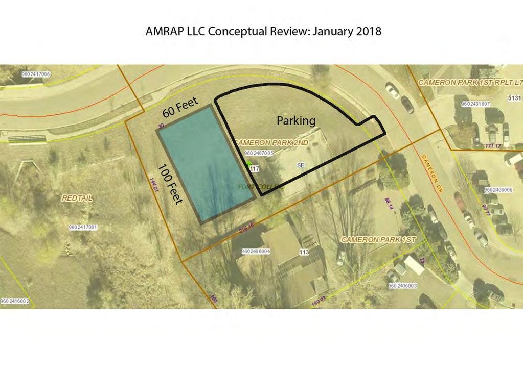
1 Conceptual Review Agenda Schedule for 01/22/18 to 01/22/ Conference Room A Monday, January 22, 2018 Time Project Name Applicant Info Project Description Planner 9: Cameron Dr - Health Club CDR Jon McKeon (970) jon@crossfit-evolve.com This is a request to construct a 6,000 square, single-story foot gym/health club at 117 Cameron Dr (parcel # ). The proposed site plan shows the building at the southwest portion of the lot with parking and site access along Cameron Dr. The proposed project is within the General Commercial (CG) zone district and is subject to Administrative (Type 1) review. Pete Wray 10:15 N Mason Storage CDR Matt Rankin (970) matt@r4architects.com This is a request to construct a 20-unit enclosed storage facility at North Mason and Hemlock Streets (parcel #s , ). The property would be accessed from the north off Hemlock St with a second emergency access located along the south at Pinon St. On-site detention is provided at the south end of the property. The proposed project is within the Service Commercial (CS) zone district and is subject to Administrative (Type 1) review. Clay Frickey Agenda as of 01/10/18 at 9:18 am Page 1 of 2
2 Monday, January 22, 2018 Time 11:00 Project Name Applicant Info Project Description Planner 1621 W Harmony WTE CDR Shawn Turk (720) turks@bv.com This is a request to install cellular equipment at 1621 W Harmony Rd (parcel# ). The proposal includes 9 new wireless antennas and support equipment; the existing place of worship has a central lighthouse/cupola feature and the equipment would be placed within this feature. The feature would be rebuilt with materials compatible with the equipment and would thus increase 5 feet in height. Accessory ground equipment would be screened by a 6-foot fence behind the existing building. The proposed project is within the Low-Density Mixed-Use (LMN) zone district and is subject to Planning and Zoning Board (Type 2) review. Clark Mapes Agenda as of 01/10/18 at 9:18 am Page 2 of 2


3 Taft Hill Lemay Timberline 117 Cameron Dr Gym/Health Club Vicinity Map UV 14 «1 Douglas Mountain Vista Aerial Site Map Vine Mulberry Prospect Shields Drake Horsetooth Harmony Conejos Rd Coronado Ct ^_ Trilby 1 inch = 16,667 feet Cameron Dr Zoning Map W Fairway Ln Fairway Ln UE Conejos Rd CG Cameron Dr Frontage Rd POL S College Ave RL 1 inch = 494 feet 1 inch = 133 feet These map products and all underlying data are developed for use by the City of Fort Collins for its internal purposes only, and were not designed or intended for general use by members of the public. The City makes no representation or warranty as to its accuracy, timeliness, or completeness, and in particular, its accuracy in labeling or displaying dimensions, contours, property boundaries, or placement of location of any map features thereon. THE CITY OF FORT COLLINS MAKES NO WARRANTY OF MERCHANTABILITY OR WARRANTY FOR FITNESS OF USE FOR PARTICULAR PURPOSE, EXPRESSED OR IMPLIED, WITH RESPECT TO THESE MAP PRODUCTS OR THE UNDERLYING DATA. Any users of these map products, map applications, or data, accepts same AS IS, WITH ALL FAULTS, and assumes all responsibility of the use thereof, and further covenants and agrees to hold the City harmless from and against all damage, loss, or liability arising from any use of this map product, in consideration of the City's having made this information available. Independent verification of all data contained herein should be obtained by any users of these products, or underlying data. The City disclaims, and shall not be held liable for any and all damage, loss, or liability, whether direct, indirect, or consequential, which arises or may arise from these map products or the use thereof by any person or entity.

4 Development Review Guide STEP 2 of 8 CONCEPTUAL REVIEW: APPLICATION General Information All proposed development projects begin with Conceptual Review. Anyone with a development idea can schedule a Conceptual Review meeting to get feedback on prospective development ideas. At this stage, the development idea does not need to be finalized or professionally presented. However, a sketch plan and this application must be submitted to City Staff prior to the Conceptual Review meeting. The more information you are able to provide, the better feedback you are likely to get from the meeting. Please be aware that any information submitted may be considered a public record, available for review by anyone who requests it, including the media. Conceptual Reviews are scheduled on three Monday mornings per month on a first come, first served basis. One 45 meeting is allocated per applicant and only three conceptual reviews are done each Monday morning. Conceptual Review is a free service. Complete applications and sketch plans must be submitted to City Staff no later than 5 pm, two Tuesdays prior to the meeting date. Application materials must be ed to currentplanning@fcgov.com. If you do not have access to , other accommodations can be made upon request. At Conceptual Review, you will meet with Staff from a number of City departments, such as Community Development and Neighborhood Services (Zoning, Current Planning, and Development Review Engineering), Light and Power, Stormwater, Water/Waste Water, Advance Planning (Long Range Planning and Transportation Planning) and Poudre Fire Authority. Comments are offered by staff to assist you in preparing the detailed components of the project application. There is no approval or denial of development proposals associated with Conceptual Review. At the meeting you will be presented with a letter from staff, summarizing comments on your proposal. The more info provided, the more detailed your comments from staff will be. Contact Name(s) and Role(s) (Please identify whether Consultant, Owner, etc.) Business Name (if applicable) Mailing Address Phone Address Site Address (parcel # if address in not available) Description of Proposal (attach additional sheets if necessary) Proposed Use Existing Use Total Building Square Footage Number of Stories Lot Dimensions Age of any Existing Structures Info available on Larimer County s Website: If any structures are 50+ years old, good quality, color photos of all sides of the structure are required for conceptual. Is your property in a Flood Plain? Yes No If yes, then at what risk is it? Info available on FC Maps: Increase in Impervious Area S.F. (Approximate amount of additional building, pavement, or etc. that will cover existing bare ground to be added to the site) Suggested items for the Sketch Plan: Property location and boundaries, surrounding land uses, proposed use(s), existing and proposed improvements (buildings, landscaping, parking/drive areas, water treatment/detention, drainage), existing natural features (water bodies, wetlands, large trees, wildlife, canals, irrigation ditches), utility line locations (if known), photographs (helpful but not required). Things to consider when making a proposal: How does the site drain now? Will it change? If so, what will change? Community Development & Neighborhood Services 281 N College Ave Fort Collins, CO
5


6 Taft Hill Lemay Timberline N Mason St Executive Storage Vicinity Map UV 14 «1 Douglas Aerial Site Map Mountain Vista ^_ Vine Prospect Mulberry Hemlock St Shields Drake Horsetooth Harmony Trilby 1 inch = 16,667 feet N Mason St Pinon St Zoning Map Hemlock St Legacy Park «14 Legacy Park POL N Mason St CS Pinon St Alpine St N College Ave Cache la Poudre River Cache la Poudre River Woodlawn Dr Lee Martinez Community Park Lee Martinez Community Park Woodlawn Dr 1 inch CCR = 493 CCN feet 1 inch = 133 feet These map products and all underlying data are developed for use by the City of Fort Collins for its internal purposes only, and were not designed or intended for general use by members of the public. The City makes no representation or warranty as to its accuracy, timeliness, or completeness, and in particular, its accuracy in labeling or displaying dimensions, contours, property boundaries, or placement of location of any map features thereon. THE CITY OF FORT COLLINS MAKES NO WARRANTY OF MERCHANTABILITY OR WARRANTY FOR FITNESS OF USE FOR PARTICULAR PURPOSE, EXPRESSED OR IMPLIED, WITH RESPECT TO THESE MAP PRODUCTS OR THE UNDERLYING DATA. Any users of these map products, map applications, or data, accepts same AS IS, WITH ALL FAULTS, and assumes all responsibility of the use thereof, and further covenants and agrees to hold the City harmless from and against all damage, loss, or liability arising from any use of this map product, in consideration of the City's having made this information available. Independent verification of all data contained herein should be obtained by any users of these products, or underlying data. The City disclaims, and shall not be held liable for any and all damage, loss, or liability, whether direct, indirect, or consequential, which arises or may arise from these map products or the use thereof by any person or entity.
7


8 Hemlock Access control 8' - 6" Greeley water line easement 2' - 6" Gate Office Property Location Storage Concrete Apron Storage North Mason 2 Vicinity Map 1/2" = 1'-0" T 31' - 4" SCOPE Gate Construction of enclosed, single story RV and vehicle storage facility in CS zoning designation. Facility will include: Management Office 20 enclosed storage units Parking: 5 spaces including handicap Detention/water quality Trash Gate and secured yard Emergency Access Only Roadbase or Asphalt Pinon Street Property locatoin Detention / Water Quality Sheet flow from North CS-Service Commercial District Demo/remove 3 Zoning Map 1/4" = 1'-0" 4 Parcel Map 1/4" = 1'-0" 1 Site Plan 1" = 40'-0" Project Number: /13/17 Executive Storage Site Survey ARCHITECTS 117 E. Mountain Ave. Suite 205 Fort Collins, CO phone 970/ fax 970/


9 Taft Hill Lemay Timberline Chippendale Dr 1621 W Harmony Wireless Equipment Vicinity Map UV 14 «1 Seneca St Douglas Mountain Vista Aerial Site Map Hilburn Ct Vine Mulberry Prospect Shields ^_ Drake Horsetooth Harmony Chokecherry Trl W Harmony Rd Prairie Ridge Dr Zoning Map Briargate Ct Seneca St Morning Dove Ln Morning Dove Ct Trilby 1 inch = 16,667 feet Hilburn Ct RL Craig Dr W Harmony Rd Hilburn Dr Dusty Sage Dr Prairie Ridge Dr Morning Dove Ln LMN Chokecherry Trl Blue Sage Dr UE Dusty Sage Loop POL 1 inch = 493 feet 1 inch = 150 feet These map products and all underlying data are developed for use by the City of Fort Collins for its internal purposes only, and were not designed or intended for general use by members of the public. The City makes no representation or warranty as to its accuracy, timeliness, or completeness, and in particular, its accuracy in labeling or displaying dimensions, contours, property boundaries, or placement of location of any map features thereon. THE CITY OF FORT COLLINS MAKES NO WARRANTY OF MERCHANTABILITY OR WARRANTY FOR FITNESS OF USE FOR PARTICULAR PURPOSE, EXPRESSED OR IMPLIED, WITH RESPECT TO THESE MAP PRODUCTS OR THE UNDERLYING DATA. Any users of these map products, map applications, or data, accepts same AS IS, WITH ALL FAULTS, and assumes all responsibility of the use thereof, and further covenants and agrees to hold the City harmless from and against all damage, loss, or liability arising from any use of this map product, in consideration of the City's having made this information available. Independent verification of all data contained herein should be obtained by any users of these products, or underlying data. The City disclaims, and shall not be held liable for any and all damage, loss, or liability, whether direct, indirect, or consequential, which arises or may arise from these map products or the use thereof by any person or entity.
10 Development Review Guide STEP 2 of 8 CONCEPTUAL REVIEW: APPLICATION General Information All proposed development projects begin with Conceptual Review. Anyone with a development idea can schedule a Conceptual Review meeting to get feedback on prospective development ideas. At this stage, the development idea does not need to be finalized or professionally presented. However, a sketch plan and this application must be submitted to City Staff prior to the Conceptual Review meeting. The more information you are able to provide, the better feedback you are likely to get from the meeting. Please be aware that any information submitted may be considered a public record, available for review by anyone who requests it, including the media. Conceptual Reviews are scheduled on three Monday mornings per month on a first come, first served basis. One 45 meeting is allocated per applicant and only three conceptual reviews are done each Monday morning. Conceptual Review is a free service. Complete applications and sketch plans must be submitted to City Staff no later than 5 pm, two Tuesdays prior to the meeting date. Application materials must be ed to currentplanning@fcgov.com. If you do not have access to , other accommodations can be made upon request. At Conceptual Review, you will meet with Staff from a number of City departments, such as Community Development and Neighborhood Services (Zoning, Current Planning, and Development Review Engineering), Light and Power, Stormwater, Water/Waste Water, Advance Planning (Long Range Planning and Transportation Planning) and Poudre Fire Authority. Comments are offered by staff to assist you in preparing the detailed components of the project application. There is no approval or denial of development proposals associated with Conceptual Review. At the meeting you will be presented with a letter from staff, summarizing comments on your proposal. *BOLDED ITEMS ARE REQUIRED* *The more info provided, the more detailed your comments from staff will be.* Contact Name(s) and Role(s) (Please identify whether Consultant or Owner, etc) Shawn Turk, Consultant on behalf of Verizon Wireless Business Name (if applicable) Black & Veatch Your Mailing Address 4600 S. Syracuse Street, Denver, CO Phone Number Address turks@bv.com Site Address or Description (parcel # if no address) 1621 Harmony Road, Fort Collins, CO 80526, APN Description of Proposal (attach additional sheets if necessary) Installation of 9 new wireless antennas, with support equipment, within lighthouse enclosure. Enclosure will be replaced to accommodate RF transparent materials, increasing height by 5'. Ground equipment to be screened by new 6' fence behind existing building. Proposed Use Wireless Facility Existing Use Church Total Building Square Footage 7,638 S.F. Number of Stories 1 Lot Dimensions 250' x 462' Age of any Existing Structures 1982 Info available on Larimer County s Website: If any structures are 50+ years old, good quality, color photos of all sides of the structure are required for conceptual. x Is your property in a Flood Plain? Yes No If yes, then at what risk is it? Info available on FC Maps: Increase in Impervious Area None S.F. (Approximate amount of additional building, pavement, or etc. that will cover existing bare ground to be added to the site) Suggested items for the Sketch Plan: Property location and boundaries, surrounding land uses, proposed use(s), existing and proposed improvements (buildings, landscaping, parking/drive areas, water treatment/detention, drainage), existing natural features (water bodies, wetlands, large trees, wildlife, canals, irrigation ditches), utility line locations (if known), photographs (helpful but not required). Things to consider when making a proposal: How does the site drain now? Will it change? If so, what will change? Community Development & Neighborhood Services 281 N College Ave Fort Collins, CO

11 ANTENNAS PENETRATIONS EXISTING CONDITIONS SITE NAME: PROJECT SITE ADDRESS: VICINITY MAP FTC WESTBURY NEW BUILD - CONCEPT 1621 WEST HARMONY ROAD FORT COLLINS, CO DRAWING INDEX VERIZON WIRELESS SERVICES 3131 S. VAUGHN WAY, SUITE 550 AURORA, CO PROJECT INFORMATION SITE NAME FTC WESTBURY 1621 WEST HARMONY ROAD FORT COLLINS, CO CONSULTANT SHEET DESCRIPTION LEASE AREA EXISTING EASEMENT ACCESS/UTILITY EASEMENT GEN. CONST./UTILITY EASEMENT CHOKECHERRY TRAIL NOT TO SCALE DIRECTIONS SITE CHIPPENDALE DR. E. HARMONY RD. (6.4 MILES) (56 MILES) I-25 DENVER FROM DENVER I-25 NORTH (56 MILES) EXIT 265 TURN LEFT TO HEAD WEST ON E. HARMONY ROAD LEFT ON EAST HARMONY ROAD (6.4 MILES) SITE IS ON THE LEFT WITH A DIRT ACCESS ROAD AFTER CHIPPENDALE DRIVE EXIT 265 N T1.0 TITLE SHEET LS1 TOPOGRAPHIC SURVEY (DRAFT) A1.0 SITE PLAN A2.0 ENLARGED SITE PLAN A2.1 ANTENNA PLAN A3.0 ELEVATIONS A3.1 ELEVATIONS A 11/27/17 CONCEPT IMR 1st REVIEW KMS 2nd REVIEW SGP OVP/ELEC. EQ. POWER/GROUNDING BBU/RRH MW/FIBER EQ. HYBRID & COAX CABLES FIBER PROJECT DESCRIPTION (6) NEW AND (3) FUTURE VERIZON WIRELESS ANTENNAS AND EQUIPMENT WITHIN RF TRANSPARENT LIGHTHOUSE CUPOLA NEW OUTDOOR EQUIPMENT CABINETS AND DIESEL GENERATOR WITHIN NEW FENCED LEASE AREA NEW U.G. ELECTRICAL SERVICE NEW U.G. FIBER SERVICE PROJECT TEAM OWNER INTERNATIONAL CHURCH OF THE FOUR SQUARE GOSPEL AARON SCHULER 1910 W. SUNSET BLVD #200 LOS ANGELES, CA PHONE: CLIENT VERIZON WIRELESS CONSTRUCTION ENGINEER JASON SHELLEDY 3131 S. VAUGHN WAY SUITE 550 AURORA CO, CELL: RF ENGINEER VERIZON WIRELESS RAM NANDIRAJU 3131 S. VAUGHN WAY SUITE 550 AURORA, CO PHONE: SITE ACQUISITIONIST BLACK & VETCH SHAWN TURK 4600 S. SYRACUSE STREET SUITE 800 DENVER, CO PHONE: SURVEYOR RLF CONSULTING, LLC 1214 N. STADEM DR TEMPE, AZ PHONE: PROJECT DATA JURISDICTION CITY OF FORT COLLINS APN ZONING DESIGNATION LOW DENSITY MIXED USE EXISTING BUILDING OCCUPANCY GROUP A-3 CONSTRUCTION TYPE V-B FULLY SPRINKLERED NO NO. STORIES 1 EQUIPMENT AREA OCCUPANCY GROUP CONSTRUCTION TYPE FULLY SPRINKLERED NO. STORIES U V-B, NEMA 3R N/A N/A GOVERNING CODES: 2015 IBC, 2015 IFC, 2015 IMC, 2015 IECC, 2017 NEC A.D.A. COMPLIANCE THIS FACILITY IS UNMANNED AND NOT FOR HUMAN HABITATION ARCHITECT CSAi CHARLES STECKLY, AIA 5935 S. ZANG STREET SUITE 280 LITTLETON, CO CELL: OFFICE: SOUTH ZANG STREET, SUITE 280 LITTLETON, COLORADO OFFICE: NOT FOR CONSTRUCTION TITLE SHEET T1.0


 ESTABLISHED FROM GPS DERIVED ELLIPSOID HEIGHTS, APPLYING GEOID 09 SEPARATIONS CONSTRAINING TO NGS CORS")

12 EM GM WV Y EM GM SURVEYOR NOTES 1. ALL TITLE INFORMATION IS BASED UPON A COMMITMENT FOR TITLE INSURANCE PREPARED BY OLD REPUBLIC TITLE NATIONAL TITLE COMPANY, ORDER NO.: T EFFECTIVE DATE: 10/09/ SURVEYOR HAS NOT PERFORMED A SEARCH OF PUBLIC RECORDS TO DETERMINE ANY DEFECT IN TITLE. 3. THE BOUNDARY SHOWN HEREON IS PLOTTED FROM RECORD INFORMATION AND DOES NOT CONSTITUTE A BOUNDARY SURVEY OF THE PROPERTY. 4. SURVEYOR DOES NOT GUARANTEE THAT ALL UTILITIES ARE SHOWN OR THEIR LOCATIONS. IT IS THE RESPONSIBILITY OF THE CONTRACTOR AND DEVELOPER TO CONTACT BLUE STAKE AND ANY OTHER INVOLVED AGENCIES TO LOCATE ALL UTILITIES PRIOR TO CONSTRUCTION. REMOVAL, RELOCATION AND/ OR REPLACEMENT IS THE RESPONSIBILITY OF THE CONTRACTOR. PROJECT META DATA 1. ELEVATIONS SHOWN HEREON ARE REPRESENTED IN NORTH AMERICAN VERTICAL DATUM OF 1988 (NAVD88) ESTABLISHED FROM GPS DERIVED ELLIPSOID HEIGHTS, APPLYING GEOID 09 SEPARATIONS CONSTRAINING TO NGS CORS STATIONS PROVIDED IN THE "ONLINE POSITIONING USER SERVICE" (OPUS) SOLUTION FOR THIS SPECIFIC SITE. 2. BEARINGS SHOWED HEREON ARE BASED UPON U.S. STATE PLANE NAD83 COORDINATE SYSTEM COLORADO STATE PLANE COORDINATE ZONE NORTH, DETERMINED BY GPS OBSERVATIONS. 3. FIELD WORK FOR THIS PROJECT WAS PERFORMED ON 11/08/17. FLOOD ZONE DESIGNATION THE PROPOSED LEASE PREMISES SHOWN HEREON APPEAR TO BE WITHIN FLOOD ZONE "X" AS DELINEATED ON THE FEDERAL EMERGENCY MANAGEMENT AGENCY FIRM MAP NO C1000F DATED 12/19/06. FLOOD ZONE "X" IS DEFINED AS: AREAS DETERMINED TO BE OUTSIDE 500-YEAR FLOODPLAIN; DETERMINED TO BE OUTSIDE THE 1% AND 0.2% ANNUAL CHANCE FLOODPLAINS. HARMONY RD. CHOKECHERRY TRL. PRAIRIE RIDGE DR. PROJECT AREA CHIPPENDALE DR. REGENCY DR S. VAUGHN WAY, SUITE 550 AURORA, CO LESSOR'S LEGAL DESCRIPTION SITUATED IN THE COUNTY OF LARIMER, STATE OF COLORADO: LIGHTHOUSE DETAIL N.T.S A PARCEL OF LAND SITUATE IN THE NW 1/4 OF SECTION 3, TOWNSHIP 6 NORTH, RANGE 69 WEST OF THE 6TH P.M., COUNTY OF LARIMER, STATE OF COLORADO, BEING MORE PARTICULARLY DESCRIBED AS FOLLOWS: CONSIDERING THE NORTH LINE OF SAID NW 1/4 AS BEARING N 89 00'00" E AND WITH ALL BEARINGS CONTAINED HEREIN RELATIVE THERETO: BEGINNING AT THE NORTH 1/4 CORNER OF SAID SECTION 3; THENCE ALONG THE NORTH-SOUTH CENTERLINE OF SAID SECTION, SAID LINE ALSO BEING THE WEST LINE OF THE RIDGE, PUD SUBDIVISION, S 00 37'30" E A DISTANCE OF FEET; THENCE PARALLEL TO THE NORTH LINE OF SAID SECTION S 89 00'00" W, A DISTANCE OF FEET; THENCE PARALLEL TO THE WEST LINE OF THE RIDGE PUD SUBDIVISION, N 00 37'30" W, A DISTANCE OF FEET-MORE OR LESS TO THE. NORTH SECTION LINE; THENCE ALONG THE NORTH LINE OF SAID SECTION, N 89 00'00" E, A DISTANCE OF FEET MORE OR LESS TO THE NORTH 1/4 CORNER OF SAID SECTION AND THE TRUE POINT OF BEGINNING. EXCEPT THE NORTH 60 FEET FOR A ROAD RIGHT OF WAY, COUNTY OF LARIMER, STATE OF COLORADO. SCHEDULE B EXCEPTIONS 1. SUBJECT TO THE RIGHT OF WAY SET FORTH IN THE DEED, RECORDED 02/24/1981, IN BOOK 73, PAGE 64 OF THE LARIMER COUNTY RECORDS. (ILLEGIBLE DOCUMENT) 2. SUBJECT TO THE RIGHT OF WAY SET FORTH IN THE DEED, RECORDED 02/13/1897, IN BOOK 77, PAGE 191 OF THE LARIMER COUNTY RECORDS. (ILLEGIBLE DOCUMENT) 3. EXEMPTION PLAT, RECORDED 01/23/1980, IN BOOK 2020, PAGE 734 OF THE LARIMER COUNTY RECORDS. (REFERENCED) 5. RIGHT-OF-WAY EASEMENT IN FAVOR OF POUDRE VALLEY RURAL ELECTRIC ASSOCIATION, RECORDED 12/11/1980 IN BOOK 2091, PAGE 510 OF LARIMER COUNTY RECORDS. (REFERENCED) ITEMS 1, 2, 4, AND 6 OF THE CLIENT PROVIDED TITLE REPORT DO NOT CONTAIN GRAPHICALLY PLOTTABLE EASEMENTS, SETBACKS, RESTRICTIONS OR OTHER ENCUMBRANCES. THE SURVEYOR CANNOT GUARANTEE THAT NON-PLOTTABLE ENCUMBRANCES DO NOT EXIST THAT MAY AFFECT THE SUBJECT LEASED PREMISES. TOP OF PIPE = (40' A.G.L) PEAK = (39.2' A.G.L) RAILING = (32.1' A.G.L) DECK = (28.5' A.G.L) ACHH N.W. COR. LOT 3, SEC. 3, T. 6 N., R. 69 W. EV APN: N0 05' 30"E ' HARMONY ROAD TBC1= FO FO FV G 60' R.O.W. FO FO FO G G G G G G G G 3 5 SS SS TBC1= SS SS TREE TBC1= G G G G G G G G G G NG 5136 D/W NG TREE 12" NG FO FO SD SD SD SD SD SD SD TBC Ø Ø TREE 16" TREE 16" Ø BLDG PEAK NG TREE TREE TREE EP PEAK LESSOR'S PARCEL LINE NG N89 40' 23"E ' TREE N89 40' 23"E ' TREE NG EP BLDG NG TREE PEAK S89 40' 23"W ' TREE APN: APN: APN: NG TREE 12" TREE TREE (E) 18.5' LIGHT POLE NG TREE 16" Ø TREE 18" Ø NG BLDG Ø NG (E) SIGN TREE ' ' T H SS D NG TREE 12" Ø TREE NG NG 5127 Ø TREE 24" Ø TREE 16" SS D BLDG NG T NG REBAR REBAR REBAR D/W 5124 SD 5130 SS FO 5122 WDF1= T TREE WDF1= TREE TREE TREE TREE S0 05' 31"W ' ACHH N. 1 4 COR. SEC. 3, T. 6 N., R. 69 W TREE NG APN: T NG TBC TBC1= NG TREE FO TV FO FO FO FO FO FO FO FO FO FO FO FO WDF1= Ø T T T FO FO FO GAS GAS SS SS SS W W W APN ASSESSORS PARCEL NUMBER BLDG BUILDING D/W DRIVEWAY EP EDGE OF PAVEMENT NG NATURAL GRADE PV ASPHALT SW SIDEWALK R.O.W. RIGHT OF WAY TBC TOP OF CURB ALUMINUM CAP IN HANDHOLE (ACHH) REBAR AIR CONDITIONING UNIT E ELECTRICAL PULL BOX ELECTRIC METER EV ELECTRIC VAULT FO FIBER MANHOLE FV FIBER VAULT TELEPHONE PEDESTAL TV TELEVISION RISER LIGHT POST GAS METER Y FIRE HYDRANT WV WATER VALVE SANITARY SEWER CLEANOUT D STORM MANHOLE DRY WELL H 2 D NG DECIDUOUS TREE CURB STOP BREAKLINE SPOT ELEVATION SCHEDULE B HEX PROPERTY LINE PROPERTY LINE (OTHER) MONUMENT LINE CENTERLINE WOOD FENCE U/G ELECTRIC LINE U/G TELECOMMUNICATION LINE U/G FIBER OPTIC LINE U/G GAS LINE SANITARY SEWER LINE STORM SEWER LINE WATER LINE FIELD BY: DRAWN BY: CHECKED BY: REVISIONS 1 11/16/17 PRELIMINARY NO. DATE DESCRIPTION REUSE OF DOCUMENT THE IDEAS & DESIGN INCORPORATED HEREON, AS AN INSTRUMENT OF PROFESSIONAL SERVICE, IS THE PROPERTY OF RLF CONSULTING, LLC & IS NOT TO BE USED FOR ANY OTHER PROJECT WITHOUT WRITTEN AUTHORIZATION OF RLF CONSULTING, LLC. PROJECT No SITE NAME: FTC WESTBURY JWS JTJ RLF COLORADO LICENSED PROFESSIONAL LAND SURVEYOR RYAN L. FIDLER SITE ADDRESS: 1621 W. HARMONY RD. NORTH 08 22' MAGNETIC DECLINATION FORT COLLINS CO, SHEET TITLE: TOPOGRAPHIC SURVEY GROUND = (0.0' A.G.L) SHEET NO. LS-1 REVISION:
13 ANTENNAS PENETRATIONS (E) ELEC. VAULT IN R.O.W. W. HARMONY RD. VERIZON WIRELESS SERVICES 3131 S. VAUGHN WAY, SUITE 550 AURORA, CO PROJECT INFORMATION SITE NAME FTC WESTBURY 1621 WEST HARMONY ROAD FORT COLLINS, CO NEW VERIZON WIRELESS FIBER HH MMP (FINAL LOCATION T.B.D.) CONSULTANT LEASE AREA EXISTING EASEMENT ACCESS/UTILITY EASEMENT GEN. CONST./UTILITY EASEMENT OVP/ELEC. EQ. POWER/GROUNDING BBU/RRH MW/FIBER EQ. HYBRID & COAX CABLES FIBER CHOKECHERRY TRAIL (E) DIRT DRIVEWAY (TYP) (E) TREE (TYP) (E) BUILDING A3.1 2 REMOVE (E) LIGHTHOUSE ENCLOSURE & REPLACE W/ NEW 16'H FG CUPOLA RE: A2.1 (E) PROPERTY LINE( APPROX.) NEW 5'W VERIZON WIRELESS UTILITY EASEMENT 2 A3.0 A ' - 0" 1 A3.1 NEW U.G. FIBER CONDUIT IN NEW VERIZON WIRELESS ACCESS & UTILITY EASEMENT (APPROX. 330 L.F.) NEW 15'W VERIZON WIRELESS ACCESS & UTILITY EASEMENT NEW U.G. PRIMARY CONDUIT IN NEW VERIZON WIRELESS ACCESS & UTILITY EASEMENTS (APPROX. 515 L.F.) (E) BUILDING (6) NEW & (3) FUTURE VERIZON WIRELESS ANTENNAS & EQUIPMENT BEHIND NEW RF TRANSPARENT LIGHTHOUSE RE: A2.1 NEW VERIZON WIRELESS OUTDOOR EQUIPMENT AND OUTDOOR GENERATOR IN NEW VERIZON WIRELESS LEASE AREA RE: A2.0 (2) NEW 6x12 HYBRID CABLES FROM NEW OUTDOOR EQUIPMENT TO NEW ANTENNAS 1-SITE PLAN 1" = 60'-0" (E) BUILDING CHIPPENDALE DR. A 11/27/17 CONCEPT IMR 1st REVIEW KMS 2nd REVIEW 5935 SOUTH ZANG STREET, SUITE 280 LITTLETON, COLORADO OFFICE: NOT FOR CONSTRUCTION SITE PLAN A1.0 SGP
14 ANTENNAS PENETRATIONS NEW PENETRATION INTO CHURCH ATTIC FOR HYBRID CABLES (2) NEW 2" HYBRID CABLE CONDUITS ATTACHED TO BUILDING, PAINT TO MATCH (E) BUILDING (E) BUILDING VERIZON WIRELESS SERVICES 3131 S. VAUGHN WAY, SUITE 550 AURORA, CO PROJECT INFORMATION SITE NAME FTC WESTBURY 1621 WEST HARMONY ROAD FORT COLLINS, CO CONSULTANT (E) CONC. SIDEWALK LEASE AREA EXISTING EASEMENT NEW U.G. CONDUIT FOR (2) 6x12 HYBRID CABLES IN NEW 5'W VERIZON WIRELESS UTILITY EASEMENT (E) GARAGE NEW U.G. ELEC. CONDUIT A 11/27/17 CONCEPT IMR ACCESS/UTILITY EASEMENT GEN. CONST./UTILITY EASEMENT OVP/ELEC. EQ. POWER/GROUNDING BBU/RRH MW/FIBER EQ. HYBRID & COAX CABLES FIBER 14' - 0" VERIZON WIRELESS LEASE AREA 11" 11' - 0" CONC. SLAB 2' - 0" CONNECT NEW LEADER TO (E) DOWNSPOUT 4"D 3/4" CRUSHED GRAVEL OVER (2) LAYERS OF LANDSCAPE FABRIC INSIDE FENCED AREA FUT. RF/PDF CAB NEW BATT. CAB NEW RF/PDF CAB NEW 6'H CEDAR FENCE (TYP) NEW 10'W CEDAR DOUBLE GATE 3' - 0" 5' - 0" NEW 30 KW DIESEL GENERATOR 3' - 0" (2) NEW & (1) FUT. VERIZON WIRELESS OUTDOOR EQUIPMENT CABINETS ON STL. PLINTH ON CONC. SLAB 1' - 2" 5' - 6" CONC. SLAB 1' - 7" 10' - 0" CEDAR GATE 1' - 10" 20' - 0" 5' - 0" 25' - 0" VERIZON WIRELESS LEASE AREA 3' - 0" (E) DOWNSPOUT NEW STEEL BOLLARD (TYP OF 2) NEW TRANSFORMER BY POWER COMPANY NEW H-FRAME W/ METER AND DISCONNECTS NEW H-FRAME W/ ILC & GPS NEW GPS ANTENNA NEW U.G. FIBER CONDUIT NEW 15'W VERIZON WIRELESS ACCESS & UTILITY EASEMENT (E) GRAVEL DRIVE & PARKING LOT 1- ENLARGED SITE PLAN 1/4" = 1'-0" 1st REVIEW KMS 2nd REVIEW 5935 SOUTH ZANG STREET, SUITE 280 LITTLETON, COLORADO OFFICE: NOT FOR CONSTRUCTION ENLARGED SITE PLAN A2.0 SGP
15 ANTENNAS PENETRATIONS VERIZON WIRELESS SERVICES 3131 S. VAUGHN WAY, SUITE 550 AURORA, CO PROJECT INFORMATION SITE NAME FTC WESTBURY 1621 WEST HARMONY ROAD FORT COLLINS, CO CONSULTANT LEASE AREA EXISTING EASEMENT 10' - 5" 'X' SECTOR AZIMUTH = 20 A 11/27/17 CONCEPT IMR ACCESS/UTILITY EASEMENT GEN. CONST./UTILITY EASEMENT 2' - 0" O.C. (TYP) (E) GUARD RAIL REMOVE (E) LIGHTHOUSE ENCLOSURE & REPLACE W/ NEW 16'H FG CUPOLA 1st REVIEW KMS 2nd REVIEW SGP NEW FG FIXED OPEN LOUVER W/ VINYL INSECT SCREEN (TYP OF 6) OVP/ELEC. EQ. POWER/GROUNDING NEW ACCESS HATCH NEW OVP MOUNTED TO BACK OF ANTENNA PIPE MOUNT (TYP OF 2) NEW RRH MOUNTED TO BACK OF ANTENNA PIPE MOUNT (TYP OF 12) 5935 SOUTH ZANG STREET, SUITE 280 LITTLETON, COLORADO OFFICE: 'Z' SECTOR AZIMUTH = 260 (6) NEW & (3) FUTURE 8'H VERIZON WIRELESS ANTENNAS BBU/RRH MW/FIBER EQ. HYBRID & COAX CABLES FIBER 'Y' SECTOR AZIMUTH = 140 NEW FG FAUX WINDOW (TYP OF 3) NOT FOR CONSTRUCTION ANTENNA PLAN A NOT USED 1- VERIZON WIRELESS RAD CENTER 3/8" = 1'-0"
16 ANTENNAS PENETRATIONS LEASE AREA EXISTING EASEMENT ACCESS/UTILITY EASEMENT GEN. CONST./UTILITY EASEMENT REMOVE (E) LIGHTHOUSE ENCLOSURE & REPLACE W/ NEW 16'H FIBERGLASS CUPOLA (6) NEW AND (3) FUTURE VERIZON WIRELESS ANTENNAS & EQUIPMENT BEHIND RF TRANSPARENT CUPOLA RE: A2.1 (2) NEW 6x12 HYBRID CABLES THROUGH ATTIC TO NEW ANTENNAS (E) CHURCH BUILDING NEW VERIZON WIRELESS OUTDOOR EQUIPMENT AND OUTDOOR GENERATOR IN NEW VERIZON WIRELESS LEASE AREA RE: A2.0 (2) NEW VERTICAL CONDUITS, PAINT TO MATCH (E) BUILDING NEW 6'H CEDAR FENCE NEW METER & DISCONNECT ON NEW H-FRAME T.O. NEW LIGHTHOUSE 45' - 0" T.O. EXISTING LIGHTHOUSE (NOT SHOWN) 40' - 0" VERIZON WIRELESS RAD CENTER 37' - 6" T.O. EXISTING RAILING 32' - 1" T.O. DECK 28' - 6" 2- SOUTH ELEVATION 1/16" = 1'-0" T.O. ROOF 17' - 0" 12' - 0" GEN. GRADE 0' - 0" VENT PIPE VERIZON WIRELESS SERVICES 3131 S. VAUGHN WAY, SUITE 550 AURORA, CO st REVIEW PROJECT INFORMATION SITE NAME FTC WESTBURY 1621 WEST HARMONY ROAD FORT COLLINS, CO CONSULTANT A 11/27/17 CONCEPT IMR KMS 2nd REVIEW SGP OVP/ELEC. EQ. POWER/GROUNDING REMOVE (E) LIGHTHOUSE ENCLOSURE & REPLACE W/ NEW 16'H FIBERGLASS CUPOLA (6) NEW AND (3) FUTURE VERIZON WIRELESS ANTENNAS & EQUIPMENT BEHIND RF TRANSPARENT CUPOLA RE: A2.1 T.O. NEW LIGHTHOUSE 45' - 0" T.O. EXISTING LIGHTHOUSE (NOT SHOWN) 40' - 0" VERIZON WIRELESS RAD CENTER 37' - 6" T.O. EXISTING RAILING 32' - 1" 5935 SOUTH ZANG STREET, SUITE 280 LITTLETON, COLORADO OFFICE: (E) LIGHTHOUSE T.O. DECK 28' - 6" BBU/RRH MW/FIBER EQ. HYBRID & COAX CABLES FIBER (E) GARAGE NEW METER & DISCONNECT ON NEW H-FRAME NEW TRANSFORMER BY ELEC. COMPANY NEW STL. BOLLARD (TYP OF 2) (2) NEW 6x12 HYBRID CABLES THROUGH ATTIC TO NEW ANTENNAS (2) NEW VERTICAL CONDUITS, PAINT TO MATCH (E) BUILDING (E) CHURCH BUILDING 1- NORTH ELEVATION 1/16" = 1'-0" T.O. ROOF 17' - 0" GRADE 0' - 0" NOT FOR CONSTRUCTION ELEVATIONS A3.0
17 ANTENNAS PENETRATIONS LEASE AREA EXISTING EASEMENT REMOVE (E) LIGHTHOUSE ENCLOSURE & REPLACE W/ NEW 16'H FIBERGLASS CUPOLA (6) NEW AND (3) FUTURE VERIZON WIRELESS ANTENNAS & EQUIPMENT BEHIND RF TRANSPARENT CUPOLA RE: A2.1 (E) LIGHTHOUSE (2) NEW 6x12 HYBRID CABLES THROUGH ATTIC TO NEW ANTENNAS (E) CHURCH T.O. NEW LIGHTHOUSE 45' - 0" T.O. EXISTING LIGHTHOUSE (NOT SHOWN) 40' - 0" VERIZON WIRELESS RAD CENTER 37' - 6" T.O. EXISTING RAILING 32' - 1" T.O. DECK 28' - 6" T.O. ROOF 17' - 0" VERIZON WIRELESS SERVICES 3131 S. VAUGHN WAY, SUITE 550 AURORA, CO PROJECT INFORMATION SITE NAME FTC WESTBURY 1621 WEST HARMONY ROAD FORT COLLINS, CO CONSULTANT A 11/27/17 CONCEPT IMR ACCESS/UTILITY EASEMENT GEN. CONST./UTILITY EASEMENT T.O. GENERATOR VENT PIPE 12' - 0" NEW VERIZON WIRELESS OUTDOOR EQUIPMENT AND OUTDOOR GENERATOR IN NEW VERIZON WIRELESS LEASE AREA RE: A2.0 NEW 6'H CEDAR FENCE 2- WEST ELEVATION 1/16" = 1'-0" GRADE 0' - 0" 1st REVIEW KMS 2nd REVIEW SGP OVP/ELEC. EQ. POWER/GROUNDING BBU/RRH MW/FIBER EQ. HYBRID & COAX CABLES FIBER (2) NEW VERTICAL CONDUITS, PAINT TO MATCH (E) BUILDING (E) GARAGE T.O. GENERATOR VENT PIPE 12' - 0" NEW VERIZON WIRELESS OUTDOOR EQUIPMENT AND OUTDOOR GENERATOR IN NEW VERIZON WIRELESS LEASE AREA RE: A2.0 NEW 6'H CEDAR FENCE NEW METER & DISCONNECT ON NEW H-FRAME REMOVE (E) LIGHTHOUSE ENCLOSURE & REPLACE W/ NEW 16'H FIBERGLASS CUPOLA (6) NEW AND (3) FUTURE VERIZON WIRELESS ANTENNAS & EQUIPMENT BEHIND RF TRANSPARENT CUPOLA RE: A2.1 (2) NEW 6x12 HYBRID CABLES THROUGH ATTIC TO NEW ANTENNAS NEW STL. BOLLARD (TYP OF 2) NEW TRANSFORMER BY ELEC. COMPANY (E) LIGHTHOUSE (E) CHURCH BUILDING T.O. NEW LIGHTHOUSE 45' - 0" T.O. EXISTING LIGHTHOUSE (NOT SHOWN) 40' - 0" VERIZON WIRELESS RAD CENTER 37' - 6" T.O. EXISTING RAILING 32' - 1" T.O. DECK 28' - 6" 1- EAST ELEVATION 1/16" = 1'-0" T.O. ROOF 17' - 0" GRADE 0' - 0" 5935 SOUTH ZANG STREET, SUITE 280 LITTLETON, COLORADO OFFICE: NOT FOR CONSTRUCTION ELEVATIONS A3.1
Conceptual Review Agenda
 Conceptual Review Agenda Schedule for 06/07/18 to 06/07/18 281 Conference Room A Thursday, June 7, 2018 Time Project Name Applicant Info Project Description 9:30 10:15 1314 Red Cedar Circle CDR180035 2155
Conceptual Review Agenda
 Conceptual Review Agenda Schedule for 11/13/17 to 11/13/17 281 Conference Room A Monday, November 13, 2017 Time Project Name Applicant Info Project Description Planner 9:30 Voice of Truth Tabernacle CDR170069
Conceptual Review Agenda
 Conceptual Review Agenda Schedule for 09/12/11 to 09/12/11 281 Conference Room A Monday, September 12, 2011 Time Project Name Applicant Info Project Description Planner 9:30 Mayor of Old Town Pation -
Conceptual Review Agenda
 Conceptual Review Agenda Schedule for 07/12/18 to 07/12/18 281 Conference Room A Thursday, July 12, 2018 Time Project Name Applicant Info Project Description 9:30 Southridge Verizon WTE CDR180044 Rescheduled
Conceptual Review Agenda
 Conceptual Review Agenda Schedule for 05/08/17 to 05/08/17 281 Conference Room A Monday, May 8, 2017 Time Project Name Applicant Info Project Description Planner 9:30 920 S Overland Trail - Single-Family
Conceptual Review Agenda
 Conceptual Review Agenda Schedule for 12/13/18 281 Conference Room A Thursday, December 13, 2018 Time Project Name Applicant Info Project Description 9:30 1909 Harmony Dr CDR180091 Christopher Martin 970-388-6690
Conceptual Review Agenda
 Conceptual Review Agenda Schedule for 06/18/12 to 06/18/12 281 Conference Room A Monday, June 18, 2012 Time Project Name Applicant Info Project Description Planner 10:15 McClelland's Creek Filing 3 - Replat
Conceptual Review Agenda
 Conceptual Review Agenda Schedule for 06/21/18 to 06/21/18 281 Conference Room A Thursday, June 21, 2018 Time Project Name Applicant Info Project Description 9:30 200 E Swallow Rd CDR180041 This is a request
Conceptual Review Agenda
 Conceptual Review Agenda Schedule for 06/14/18 to 06/14/18 281 Conference Room A Thursday, June 14, 2018 Time Project Name Applicant Info Project Description Planner 9:30 Sunshine House CDR180038 Bo Brown
Conceptual Review Agenda
 Conceptual Review Agenda Schedule for 08/09/18 to 08/09/18 281 Conference Room A Thursday, August 9, 2018 Time Project Name Applicant Info Project Description 9:30 Southridge Verizon WTE CDR180044 Shawn
Conceptual Review Agenda
 Conceptual Review Agenda Schedule for 03/19/18 to 03/19/18 281 Conference Room A Monday, March 19, 2018 Time Project Name Applicant Info Project Description Planner 9:30 Purpose Brewing CDR180013 Zach
Conceptual Review Agenda
 Conceptual Review Agenda Schedule for 10/18/18 281 Conference Room A Thursday, October 18, 2018 Time Project Name Applicant Info Project Description 9:30 915 E Prospect Rd Kaycee Heid This is a request
Penny Flats North 323 N Mason
 Taft Hill Lemay Mason Ct Timberline Mason Ct Penny Flats North 323 N Mason Vicinity Map Aerial Site Map 287 «1 Douglas 25 Mountain Vista UV 14 287 ^_ Vine Mulberry Prospect Shields Drake Horsetooth 25
Jerome Street Mixed Use
 Jerome Street Mixed Use Aerial Site Map 287 N Mason St 1 «Douglas 25 Pinon St _ ^ Vine 287 Mulberry Horsetooth Timberline Drake Lemay Shields Prospect N College Ave 14 U V Taft Hill Mountain Vista Jerome
Conceptual Review Agenda
 Conceptual Review Agenda Schedule for 01/23/17 to 01/23/17 281 Conference Room A Monday, January 23, 2017 Time Project Name Applicant Info Project Description Planner 10:15 2025 Sharp Point Dr - Wireless
COUNTY OF ADAMS, STATE OF COLORADO E. 40TH AVE. TOWER RD. E. 38TH AVE. SALIDA ST. HIGH LINE CANAL PROJECT LOCATION E. 32ND PKWY.
 LEGAL DESCRIPTION:, GATEWAY EAST AT TOWER SUBDIVISION FILING NO. 1, SAID PARCEL CONTAIN 598,154 SQUARE FEET OR MORE OR LESS GENERAL NOTES: 1. NOTICE: ACCORDING TO COLORADO LAW YOU MUST COMMENCE ANY LEGAL
Residential Major Subdivision Review Checklist
 Residential Major Subdivision Review Checklist Plan Submittal Requirements: 2 full sets of stamped plans Electric submittal - all plans contained in a single PDF 3 full sets if commercial kitchen or dining
Conceptual Review Agenda
 Conceptual Review Agenda Schedule for 07/29/13 to 07/29/13 281 Conference Room A Monday, July 29, 2013 Time Project Name Applicant Info Project Description Planner 9:30 4101 S Taft Hill Rd - Annexation
PUBLIC HEARING* N/A. C I T Y O F T A C O M A Planning & Development Services Department 747 Market St, Rm 345 Tacoma, WA 98402
 C I T Y O F T A C O M A Planning & Development Services Department 747 Market St, Rm 345 Tacoma, WA 98402 PUBLIC HEARING* Date of Notifcation: 10/5/2018 Application Received: 04/19/2018 Application Complete:
Residential Minor Subdivision Review Checklist
 Residential Minor Subdivision Review Checklist Plan Submittal Requirements: 2 full sets of stamped plans Electric submittal - all plans contained in a single PDF 3 full sets if commercial kitchen or dining
WORK SESSION ITEM City Council
 DATE: STAFF: February 23, 2016 Ginny Sawyer, Policy and Proect Manager Ted Shepard, Chief Planner WORK SESSION ITEM City Council SUBJECT FOR DISCUSSION Short Term Rentals. EXECUTIVE SUMMARY The purpose
SUBMITTAL REQUIREMENTS: The number indicates the number of copies for submittal (if applicable).
.") Office Use Only Preliminary Long Plat Long Subdivision Applicant Checklist PLANNING, COMMUNITY, & ECONOMIC DEVELOPMENT DEPARTMENT PRELIMINARY LONG PLAT LONG SUBDIVISION CHECKLIST Mailing Address: P.O.
Office Use Only Preliminary Long Plat Long Subdivision Applicant Checklist PLANNING, COMMUNITY, & ECONOMIC DEVELOPMENT DEPARTMENT PRELIMINARY LONG PLAT LONG SUBDIVISION CHECKLIST Mailing Address: P.O.
FINAL SUBDIVISION AND LAND DEVELOPMENT PLAN CHECKLIST. Plan Name. Applicant's Name:
 TOWNSHIP OF UPPER ST. CLAIR FINAL SUBDIVISION AND LAND DEVELOPMENT PLAN CHECKLIST Date Filed Plan Name PLC Applicant's Name: Phone Filing Date for Final Application Final Plat 114.22. FINAL APPLICATION
DIVISION 2 - CONSTRUCTION PLAN AND MISCELLANEOUS REQUIREMENTS
 DIVISION 2 - CONSTRUCTION PLAN AND MISCELLANEOUS REQUIREMENTS 2.1 Required Plan Sheets 2.2 Drawing Requirements 2.3 Graphic Standards 2.4 Easements 2.5 Utility Locations 2.6 Private Facility Locations
PRELMINARY PLAT CHECKLIST
 PRELMINARY PLAT CHECKLIST A. All preliminary plat submitted for approval shall be prepared by a Registered Professional Land Surveyor. B. Preliminary plats must be drawn to a scale of XXX with such accuracy
PLAT OF SURVEY VICINITY MAP (NOT TO SCALE) N N W E SITE BENCHMARK # 2 W E N&D ON BACK OF CURB NAVD 88 S S 0' 10' 20' 40' 60' 1" = 20' TOP=106.7
 N N W E SITE BENCHMARK # 2 W E N&D ON BACK OF CURB NAVD 88 S S 0' 10' 20' 40' 60' 1 = 20' TOP=106.7") PLAT OF SURVEY VICINITY MAP (NOT TO SCALE) N N W E SITE BENCHMARK # 2 W E N&D ON BACK OF CURB 106.21 NAVD 88 S S 0' 10' 20' 40' 60' 1" = 20' TOP=106.72 N INV PVC=99.27 S INV PVC=99.32 E INV CLAY=99.39
PLAT OF SURVEY VICINITY MAP (NOT TO SCALE) N N W E SITE BENCHMARK # 2 W E N&D ON BACK OF CURB 106.21 NAVD 88 S S 0' 10' 20' 40' 60' 1" = 20' TOP=106.72 N INV PVC=99.27 S INV PVC=99.32 E INV CLAY=99.39
SITE PLAN REVIEW ADMINISTRATIVE REVIEW. Please Note: Once submitted to the County, all application materials become a matter of public record.
 200 W. Oak Street, 3rd Floor Fort Collins, CO 80521 (970) 498-7683 / larimer.org/planning SITE PLAN REVIEW ADMINISTRATIVE REVIEW The submittal requirements listed in this packet are intended to collect
SECTION SITE SURVEYS
 PART 1 - GENERAL 1.1 DESCRIPTION SECTION 02 21 00 SPEC WRITER NOTES: 1. Use this section only for NCA projects. 2. Delete between //---// if not applicable to project. Also delete any other item or paragraph
FINAL SPUD APPLICATION
 The Planning & Development Services Department is here to assist you with your development application pursuant to the Community Development Code (CDC). This publication outlines the Final SPUD Development
APPENDIX B. SUBMISSION REQUIREMENTS
 Master Major Site Minor Site Landscape Section B.1 Table of /Plat Requirements Proposed or approved name of development, project, subdivision, and/or phase. Location, including township, county, and state.
PLANNED UNIT DEVELOPMENT
 JAY STREET HARLAN STREET NEWLAND STREET 670, 600, & 650 W. 9TH AVE, EDGEWATER, CO 804 A PARCEL OF LAND LOCATED IN THE SOUTHEAST /4 OF THE SOUTHWEST /4 OF 5, TOWNSHIP 3 SOUTH, RANGE 69 WEST OF THE 6TH P.M.,,
Location Map Project: Olshansky Subdivision Applicant: David Olshansky Address: 16965, Cottage Grove Ave Project No a.
 Lake Minnetonka COUNTY ROAD 0 W GRAYS BAY BLVD BAY CIR BAY ST BEECHWOOD AVE Libb's Lake BAY LN BAY LN Subject Property GROVELAND PL CHARMY DNS EDGEWOOD AVE PARK LN GROVELAND SCHOOL RD WOODLAWN AVE PROSPECT
ARTICLE 900 PLAT AND PLAN REQUIREMENTS
 ARTICLE 900 PLAT AND PLAN REQUIREMENTS SEC. 900.1 ITEMS TO BE SHOWN ON PLAT OR PLAN General (1) Property lines of all property owners adjacent to the exterior boundaries of the project shall be located
AGENDA. Planning Board August 6, 2018
 AGENDA Planning Board August 6, 2018 1. Call to Order (7:00 P. M.) 2. Pledge of Allegiance 3. Roll Call 4. Approval of Minutes (June 25, 2018 & July 16, 2018) 5. Consent Item: Southgate Self-Storage, LLC
HARMONY & STRAUSS CABIN SUBDIVISION FILING NO. 1
 STATEMENT OF OWNERSHIP AND SUBDIVISION: KNOW ALL PERSONS BY THESE PRESENTS, THAT THE UNDERSIGNED OWNER(S) OF THE FOLLOWING DESCRIBED LAND: A PARCEL OF LAND BEING A PART OF THE WEST HALF OF SECTION 3, TOWNSHIP
CITY OF FAYETTEVILLE, ARKANSAS FINAL PLAT FOR STAFF USE ONLY FINAL PLAT FEE: $ $ Date Application Submitted: Date Accepted as Complete:
 CITY OF FAYETTEVILLE, ARKANSAS FINAL PLAT FOR STAFF USE ONLY FINAL PLAT FEE: $200.00-$800.00 Date Application Submitted: Date Accepted as Complete: Project Number: Public Hearing S-T-R: PP#: Zone: Please
PLANNING COMMISSION STAFF REPORT
 PLANNING COMMISSION STAFF REPORT Alder-Robinson Subdivision Amending the Amended Plat of the Arcadia Heights Plat A Subdivision Case #PLNSUB2010-00044 2857 East 2100 South June 23, 2010 Applicant: Greg
BOUNDARY DETAIL SCALE: 1" = 80'
 4. -1 7 (E) 10 PIPE LINE ESMT. BK. 7484, PG. 232 29 GV 42 R/ (E ) DE L 6 2 44 2 2 8.1 6" 0 2. SURVEYOR DOES NOT GUARANTEE THAT ALL UTILITIES ARE SHON OR THEIR LOCATIONS. IT IS THE RESPONSIBILITY OF THE
APPLICATION PROCEDURE
 ANTRIM PLANNING BOARD P. O. Box 517 Antrim, New Hampshire 03440 Phone: 603-588-6785 FAX: 603-588-2969 APPLICATION FORM AND CHECKLIST FOR MINOR OR MAJOR SITE PLAN REVIEW File Date Received By APPLICATION
CHECKLIST FOR DEVELOPMENT REVIEW
 CHECKLIST FOR DEVELOPMENT REVIEW Petitions and related documents and plans for land development or other proposals regulated by Title 16 of the Municipal Code (Development Ordinance) and Title 17 of the
CITY OF OCOEE LAND DEVELOPMENT CODE SUFFICIENCY TABLE WITH NOTES
 CITY OF OCOEE LAND DEVELOPMENT CODE SUFFICIENCY TABLE WITH NOTES The Sufficiency Table is a checklist to help identify the types of information and documentation needed for various types of projects. The
CHAPTER 26 PLANNING AND ZONING ARTICLE VII. MOBILE HOMES AND RECREATIONAL VEHICLE (RV) PARKS. Recreational Vehicle (RV) Park Development Standards
 PARKS. Recreational Vehicle (RV) Park Development Standards") CHAPTER 26 PLANNING AND ZONING ARTICLE VII. MOBILE HOMES AND RECREATIONAL VEHICLE (RV) PARKS. Section 26-VII-1. Section 26-VII-2. Section 26-VII-3. Section 26-VII-4. Section 26-VII-5. Purpose Permitted
CHAPTER 26 PLANNING AND ZONING ARTICLE VII. MOBILE HOMES AND RECREATIONAL VEHICLE (RV) PARKS. Section 26-VII-1. Section 26-VII-2. Section 26-VII-3. Section 26-VII-4. Section 26-VII-5. Purpose Permitted
Conditional Use Sketch Plan Application Non-Residential Zone
 For Office Use Only Fees received by: Date of submittal: Amount Paid: Receipt #: Initial Review, all of the required supporting materials have been provided: Sketch Plan Meeting Date: Conditional Use Sketch
QUEBEC STREET EAST 130TH AVENUE ONEIDA STREET E. 130TH AVE. VALENTIA ST TAMARAC ST EAST 128TH AVENUE MONACO STREET BACHMAN DR. SITE QUINCE ST.
 SHEET OF CASE NO.: SUBA 0-0 PURPOSE STATEMENT: THIS PLAT IS INTENDED TO SUBDIVIDE. ACRES INTO 0 SINGLE FAMILY LOTS, AND TRACTS FOR PARKS, OPEN SPACE, DRAINAGE AND DETENTION, DEDICATE RIGHT-OF-WAY AND GRANT
DETAILED GRADING PLAN CHECKLIST (TEARDOWN/REDEVELOPMENT)
") GENERAL DETAILED GRADING PLAN CHECKLIST (TEARDOWN/REDEVELOPMENT) ADDRESS: PERMIT #: DATE: 1. Plan is signed and sealed by an Illinois registered professional engineer including date signed and license
GENERAL DETAILED GRADING PLAN CHECKLIST (TEARDOWN/REDEVELOPMENT) ADDRESS: PERMIT #: DATE: 1. Plan is signed and sealed by an Illinois registered professional engineer including date signed and license
CONSTRUCTION PLANS for HALCYON A RESIDENTIAL SUBDIVISION 6100 MIDNIGHT PASS ROAD, SARASOTA, FL 34242
 CONSTRUCTION PLANS for HALCYON A RESIDENTIAL SUBDIVISION 6100 MIDNIGHT PASS ROAD, SARASOTA, FL 34242 SECTION 18, TOWNSHIP 37 SOUTH, RANGE 18 EAST SARASOTA COUNTY, FLORIDA PID: 0030001 A DEVELOPMENT BY
AIR ONE. 829 HULL ROAD Ormond Beach, Florida BENCHMARK #1 EL NAIL IN POWER POLE EASTERLY RIGHT-OF-WAY LINE TOMOKA AIRPORT ROAD (UR) HULL ROAD
 HULL ROAD") NORTH LINE LOT 2 SOUTH LINE LOT 1 S75 46'55"E 2 NORTH LINE LOT 3 SOUTH LINE LOT 2 N75 43'32"W(UR) S75 43'32"E(D) N75 43'32"W(URD) NORTH LINE LOT 1 SOUTH LINE LOT 12 225.15'(M)225'(UR) P.O.R. PARCELS II
NORTH LINE LOT 2 SOUTH LINE LOT 1 S75 46'55"E 2 NORTH LINE LOT 3 SOUTH LINE LOT 2 N75 43'32"W(UR) S75 43'32"E(D) N75 43'32"W(URD) NORTH LINE LOT 1 SOUTH LINE LOT 12 225.15'(M)225'(UR) P.O.R. PARCELS II
SUBMITTAL REQUIREMENTS: The number indicates the number of copies for submittal (if applicable).
.") Office Use Only Preliminary Long Plat Long Subdivision Applicant Checklist PLANNING, COMMUNITY, & ECONOMIC DEVELOPMENT DEPARTMENT FINAL LONG PLAT LONG SUBDIVISION CHECKLIST Mailing Address: P.O. Box 547,
Office Use Only Preliminary Long Plat Long Subdivision Applicant Checklist PLANNING, COMMUNITY, & ECONOMIC DEVELOPMENT DEPARTMENT FINAL LONG PLAT LONG SUBDIVISION CHECKLIST Mailing Address: P.O. Box 547,
Ft. Worth, TX. Walmart Outparcels For Sale. Store #2834 SEC Golden Triangle & Park Vista
 Ft. Worth, TX Walmart Outparcels For Sale Store #2834 SEC Golden Triangle & Park Vista Lot 2. lvd B le g rian T n e ld Go Lot 3 Lot 5 Lot 2: + 1.02 acres - Coming Soon Lot 3: + 1.06 acres - Coming Soon
SITE. Sheet Index. Legal Description. General Notes: Vicinity Map Scale 1" = 600'
 Quebec St. LOCATED IN THE SOHWEST QUARTER OF SECTION 8, TOWNSHIP SOH, RANE 67 WEST OF THE 6TH P.M., Case # Z 06-005 Legal Description Tract, H and J of the Filing No., a part of the Southwest quarter of
DAUPHIN CREEK ESTATES SUBDIVISION
 # 12 SUB-000076-2017 DAUPHIN CREEK ESTATES SUBDIVISION Engineering Comments: FINAL PLAT COMMENTS (should be addressed prior to submitting the FINAL PLAT for review and/or signature by the City Engineer):
PRIME HIGHWAY LOCATION Multi - Family Land Acres Waxahachie, Texas
 PRIME HIGHAY LOCATION Multi - Family Land 6.525 Acres axahachie, Texas LOCATION: SIZE: The subject property is located on the south side of U.S. Highway 287 Bypass, approximately 1.5 miles west of I-35E
Final Plat Mapping Requirements
 CURRENT PLANNING DIVISION 410 E. 5 th Street Loveland, CO 80537 970-962-2523 eplan-planning@cityofloveland.org cityofloveland.org/dc Final Plat Mapping Requirements All Final plats shall comply with the
E. 140TH AVE. VICINITY MAP SCALE: 1"=600' LAND USE TABLE NET AREA 599,946 SQFT AC. GROSS AREA 741,420 SQFT AC.
 SHEET OF PURPOSE STATEMENT: THIS PLAT IS INTENDED TO SUBDIVIDE. ACRES INTO SINGLE FAMILY ATTACHED LOTS, TRACTS, DEDICATE AND GRANT EASEMENTS. LEGAL DESCRIPTION: THE UNDERSIGNED BEING THE OWNER(S) OF A
TOWN OF EASTCHESTER BUILDING AND PLANNING DEPARTMENT PLANNING BOARD APPLICATION PACKAGE SUBDIVISIONS
 TOWN OF EASTCHESTER BUILDING AND PLANNING DEPARTMENT 40 Mill Road (914) 771-3317 building@eastchester.org Eastchester, NY 10709 (914) 771-3322 Fax www.eastchester.org TABLE OF CONTENTS PLANNING BOARD APPLICATION
LAND USE APPLICATION
 LAND USE APPLICATION File Name: File No(s).: Receipt No.: Receipt Date: Received By: Amount.: $ Instructions for Applicants Please read and follow all instructions on your application carefully. If you
CHAPTER 32 SUBDIVISIONS SECTION TITLE PAGE NO.
 Page 1 of 46 CHAPTER 32 SUBDIVISIONS SECTION TITLE PAGE NO. SECTION 32-1 Purpose of Ordinance 3 SECTION 32-2 Definitions 3 SECTION 32-3 Staff Sketch Review 4 SECTION 32-4 Subdivision and PUD Plats Required
DETAILED GRADING PLAN CHECKLIST (TEARDOWN/REDEVELOPMENT) Updated: 12/12/2017
 Updated: 12/12/2017") DETAILED GRADING PLAN CHECKLIST (TEARDOWN/REDEVELOPMENT) Updated: 12/12/2017 ADDRESS: PERMIT #: DATE: Sat. Not GENERAL 1. A disposition of comments should be included in all subsequent submittals. 2. Plan
DETAILED GRADING PLAN CHECKLIST (TEARDOWN/REDEVELOPMENT) Updated: 12/12/2017 ADDRESS: PERMIT #: DATE: Sat. Not GENERAL 1. A disposition of comments should be included in all subsequent submittals. 2. Plan
SKETCH OF BOUNDARY SURVEY ALTA / ACSM LAND TITLE SURVEY
 SKETCH OF BOUNDARY SURVEY ALTA / ACSM LAND TITLE SURVEY SURVEYOR'S NOTES: All distances as shown hereon are based on the US Survey foot. Subject property lies inside the UBD (Urban Development Boundary),
RIVERDALE CITY PLANNING COMMISSION APPLICATION FOR RESIDENTIAL SUBDIVISION SITE PLAN APPROVAL
 Community Development 4600 So. Weber River Drive Riverdale, Utah 84405 RIVERDALE CITY PLANNING COMMISSION APPLICATION FOR RESIDENTIAL SUBDIVISION SITE PLAN APPROVAL CASE NO: DATE SUBMITTED: APPLICANT S
COMMUNITY DEVELOPMENT. Staff Report. Site Plan Review. SP June 19, 2018
 COMMUNITY DEVELOPMENT 333 Broadalbin Street SW, PO Box 490, Albany, Oregon 97321-0144 BUILDING 541-917-7553 PLANNING 541-917-7550 Staff Report Site Plan Review SP-18-18 June 19, 2018 Summary On May 1,
Condominium Unit Requirements.
 ARTICLE 19 CONDOMINIUM REGULATIONS Section 19.01 Purpose. The purpose of this Article is to regulate projects that divide real property under a contractual arrangement known as a condominium. New and conversion
ABBREVIATION LEGEND SITE INFORMATION:
 SITE INFORMATION: Current Zone: R-3 PUD, governed by Fox Hollow 2nd MDA Basis of Elevations: Northeast Corner of Section 13, T6S, R1W, S.L.B. & M Elevation: 4599.26 (Benchmark) ABBREVIATION LEGEND Owners:
CERTIFIED SURVEY MAP
 SCONSIN STATE PLANE N:389676.12 E:2130390.15 Center of Section 23 CERTIFIED SURVEY MAP 734.06' THE (PRITCHETTE) ORIGINAL PLAT OF ALL IN THE NW 1 4 OF THE SE 1 4 OF FRACTIONAL SECTION 23, T7N, R9E, IN THE
Planning and Zoning Commission
 Planning and Zoning Commission Buell Consulting Conditional Use Permit Haugen Communication Tower Reason for Request: Install and maintain wireless facility, with 199 lattice type tower, prefabricated
VARIANCE PROCESS APPLICATION
 The Department is here to assist you with your development application pursuant to the Community Development Code (CDC). This publication outlines the Variance Process Development Application process of
Tentative Map Application Review Procedures
 FOR REFERENCE ONLY This page is not part of the application. Tentative Map Application Review Procedures The tentative map process in Churchill County is designed to provide a mechanism in order to divide
JOHNNY S RV PARK SUBDIVISION
 # 11 SUB2016-00001 JOHNNY S RV PARK SUBDIVISION Engineering Comments: The following comments should be addressed prior to submitting the FINAL PLAT for acceptance and signature by the City Engineer: A.
WRIGHT TOWNSHIP Ottawa County 1565 Jackson Street, P.O. Box 255, Marne, Michigan 49435
 WRIGHT TOWNSHIP Ottawa County 1565 Jackson Street, P.O. Box 255, Marne, Michigan 49435 SITE PLAN REVIEW APPLICATION _ Instructions For an application to be considered complete, ALL information must be
A.3. ARTICLE 7 PLAN REQUIREMENTS FOR MINOR SUBDIVISION AND/OR LAND DEVELOPMENT
 700. 701.A.3. ARTICLE 7 PLAN REQUIREMENTS FOR MINOR SUBDIVISION AND/OR LAND DEVELOPMENT SECTION 700 PURPOSE The purpose of this Article is to set forth a streamlined set of Plan Requirements for minor
BYRON TOWNSHIP ZONING APPLICATION
 BYRON TOWNSHIP ZONING APPLICATION Phone: (616) 878-9104 * Fax: (616) 878-3980 * Website: www.byrontownship.org This application will not be accepted if incomplete. APPLICATION FOR & REQUIRED COPIES Private
WRIGHT TOWNSHIP Ottawa County 1565 Jackson Street, P.O. Box 255, Marne, Michigan 49435
 WRIGHT TOWNSHIP Ottawa County 1565 Jackson Street, P.O. Box 255, Marne, Michigan 49435 SPECIAL USE PERMIT APPLICATION _ Instructions For an application to be considered complete, ALL information must be
ARTICLE 13 CONDOMINIUM REGULATIONS
 ARTICLE 13 CONDOMINIUM REGULATIONS Section 13.01 Purpose. The purpose of this Article is to regulate projects that divide real property under a contractual arrangement known as a condominium. New and conversion
1 Mile: Population: 14,200 Median HH Income: $62, Mile: Population: 71,100 Median HH Income: $68,600
 Walmart Outparcel For Sale Arlington (SW), TX Store # 3284 4800 Highway 287 US I-20 Lot 2 Hwy 287 Treepoint Dr Little Rd For more information about this site, contact: Lot 2: ±1.02 Acres - $850,000 Bank
FACTS & HIGHLIGHTS. The community will attract young professionals and provide a housing option for empty nesters.
 PROJECT DESCRIPTION The proposed project is located on approximately 34 acres at the south east corner of Moorland Road and Greenfield Avenue in New Berlin, WI, as shown on the enclosed concept site plan.
City of Midland Application for Site Plan Review
 City of Midland Application for Site Plan Review Submission Date: Property Owner: Mailing Address: Phone number: ( ) Cell phone: ( ) Email address: Fax: ( ) Owner s Signature: Applicant Name (if not owner):
BOSSIER CITY PARISH METROPOLITAN PLANNING COMMISSION 620 Benton Rd. Bossier City, LA Phone: Fax: PRELIMINARY PLAT
 (OFFICE USE ONLY) Application Fee: Paid: Date: CASE # Project Information BOSSIER CITY PARISH METROPOLITAN PLANNING COMMISSION 620 Benton Rd. Bossier City, LA 71111 Phone: 318-741-8824 Fax: 318-741-8827
Use permitted by: Right Special Exemption
 CENTER TOWNSHIP 150 Henricks Road Butler, PA 16001-8472 Phone (724) 282-7805 Fax (724) 282-6550 Application Number: FEE COLLECTED: Application for: Preliminary Final Land Development Location: Map and
REQUEST FOR ALTERATION REVIEW VERANDA GARDENS HOMEOWNERS ASSOCIATION, INC.
 Please Complete The Following Name: Directions: 1. Fill in requested information 2. Attach required checks Address: 3. Attach required certificates 4. Sign required forms and return to: Lot number GRS
PRELIMINARY PLAT CHECK LIST
 PRELIMINARY PLAT CHECK LIST Name of Proposed Subdivision: The following items must be included with the initial submittal of a Preliminary Plat: Application, filled out completely Project Narrative Pre-application
ARTICLE 900 PLAT AND PLAN REQUIREMENTS
 Final SEC. 900.01 ARTICLE 900 PLAT AND PLAN REQUIREMENTS General provisions. (a) Scale. The scale of all plats and plans shall be a minimum of 1 to 100 ft. (b) Size. The minimum page size for all plats
Palm Ave Hialeah Building Data Palm Avenue
 400-450 Palm Ave Hialeah Building Data Address 400-450 Palm Avenue City, State Hialeah, Florida County Miami Dade parcel # 04-3118-001-1950 and 1960 Zoning Retail Commercial - BU2 Land Size 13500 Type
COMMUNITY DEVELOPMENT DEPARTMENT 333 Broadalbin Street SW, P.O. Box 490 Albany, OR 97321
 COMMUNITY DEVELOPMENT DEPARTMENT 333 Broadalbin Street SW, P.O. Box 490 Albany, OR 97321 STAFF REPORT Application for Site Plan Review (SP-02-18) Residential Accessory Building Ph: 541-917-7550 Fax: 541-917-7598
APPLICATION SUBMITTAL REQUIREMENTS FOR Tentative Parcel or Subdivision Maps
 CITY OF EL CERRITO Community Development Department Planning and Building Division 10890 San Pablo Avenue, El Cerrito, CA 94530 (510) 215-4330 FA (510) 233-5401 planning@ci.el-cerrito.ca.us APPLICATION
I. Requirements for All Applications. C D W
 108-16.1. Application checklists. Checklist for Required Submissions to the Planning Board or Zoning Board of Adjustment of Monroe Township All required submissions are to be made to the Administrative
AGENDA OF THE COUNCIL OF THE CITY OF FORT COLLINS, COLORADO
 AGENDA OF THE COUNCIL OF THE CITY OF FORT COLLINS, COLORADO April 2, 2002 Proclamations and Presentations 5:30 p.m A. Proclamation Proclaiming the Month of April as Strategic Information Management Month.
MAJOR SUBDIVISION APPLICATION
 Revised 2.26.18 The Department is here to assist you with your development application pursuant to the Community Development Code (CDC). This publication outlines the Major Subdivision Development Application
CONDOMINIUM REGULATIONS
 ARTICLE 37 CONDOMINIUM REGULATIONS SECTION 37.01. Purpose The purpose of this Article is to regulate projects that divide real property under a contractual arrangement known as a condominium. New and conversion
FINAL PLAT CHECKLIST
 FINAL PLAT CHECKLIST Project Name: Tax ID #: Project Number: Date: _ Reviewed By: Telephone: Please address all items marked with an "X" Please return redline comments with corrected plan, original mylar,
Two Notch Road. 3 Mile: Popula on: 53,000 Median HH Income: $68, Mile: Popula on: 98,200 Median HH Income: $63,300
 Fashion Drive Sam s Club Excess For Sale Columbia, SC Store #4872 733 Fashion Dr. Excess Two tch Road For more informa on about this site, contact: Excess: 4.70 acres - $960,000 Michael Silverman The Shopping
Initial Subdivision Applications Shall Include the Following:
 Initial Subdivision Applications Shall Include the Following: 1) Subdivision Application Form: completely filled out (12 copies) 2) Plat: The Plat must adhere to the requirements set forth in the Town
SHEET 1 of 13 RECORDING REQUESTED BY AND WHEN RECORDED, RETURN TO: S&S CONTRACTORS, INC VENTURA BLVD., # 104 WOODLAND HILLS, CA 91364
 SHEET 1 of 13 RECORDING REQUESTED BY AND WHEN RECORDED, RETURN TO: S&S CONTRACTORS, INC. 22817 VENTURA BLVD., # 104 WOODLAND HILLS, CA 91364 CONDOMINIUM PLAN CONSISTING OF LOT 1 OF TRACT NO. 65890 IN THE
PLANNED UNIT DEVELOPMENT & SUBDIVISION STAFF REPORT Date: November 17, 2016
 PLANNED UNIT DEVELOPMENT & SUBDIVISION STAFF REPORT Date: November 17, 2016 DEVELOPMENT NAME SUBDIVISION NAME LOCATION Autonation Ford of Mobile Autonation Ford of Mobile Subdivision 901, 909, and 925
Accessory Dwelling Units (ADUs)
") Community Development Department Planning Division 14177 Frederick Street PO Box 8805 Moreno Valley, CA 92552-0805 (951) 413-3206 Fax (951) 413-3210 Accessory Dwelling Units (ADUs) Completed Project Application
Community Development Department Planning Division 14177 Frederick Street PO Box 8805 Moreno Valley, CA 92552-0805 (951) 413-3206 Fax (951) 413-3210 Accessory Dwelling Units (ADUs) Completed Project Application
MAPLETON CITY CORPORATION. Step 7: Upon final approval and prior to plat recording the applicant shall provide the following:
 MAPLETON CITY CORPORATION Subdivision Process The City s subdivision requirements are designed to facilitate orderly, safe and efficient development and to implement the adopted General Plan. Below is
ZONING AMENDMENT & SUBDIVISION STAFF REPORT Date: July 9, 2015
 ZONING AMENDMENT & SUBDIVISION STAFF REPORT Date: July 9, 2015 APPLICANT NAME 2513 Dauphin Street, Inc. SUBDIVISION NAME Audubon Place Extension No. 3, Resubdivision of Lots 1-5 LOCATION 2513 Dauphin Street
320 Maple Mixed Use PDR Narrative Fort Collins, CO Project # 1525
 320 Maple Mixed Use PDR Narrative Fort Collins, CO Project # 1525 July 28, 2015 (a) What are you proposing/use? A 47,00 S.F., 3-story, mixed used project with 30 for-sale condo residential units and 2
Project Description: Consider site plan approval for the construction of a new car wash in the Gateway Center subdivision.
 COMMUNITY DEVELOPMENT DEPARTMENT Planning and Zoning Division 1725 Reynolds Street, Suite 200, Brunswick, GA 31520 Phone: 912-554-7428/Fax: 1-888-252-3726 MAINLAND PLANNING COMMISSION STAFF REPORT August
Location Map. Subject Site. Project Name: Boulder Lakes 4th Addn. Request: Preliminary Subdivision Case No.: 01-PS INVER GROVE HEIGHTS
 HOLIDAY LN LOUIS LANE INVER GROVE HEIGHTS AMES CROSSING RD STATE TRUNK HWY. NO. 55 CHAPEL LANE O'NEILL DR VIKINGS PARKWAY LONE OAK DRIVE C.S.A.H. NO. 26 (LONE OAK RD.) COURTHOUSE LN TRUNK HWY. NO. 55 JOYCE
Submittal Requirements: Subdivision Plat (Final)
") s Planning and Zoning Submittal Requirements: Subdivision Plat (Final) 1. Application form, APO fees, and filing fee. Transportation Development Review Fee please contact Engineering at (970) 221-6605
s Planning and Zoning Submittal Requirements: Subdivision Plat (Final) 1. Application form, APO fees, and filing fee. Transportation Development Review Fee please contact Engineering at (970) 221-6605