Project Description: Consider site plan approval for the construction of a new car wash in the Gateway Center subdivision.
|
|
|
- Ethan Golden
- 5 years ago
- Views:
Transcription

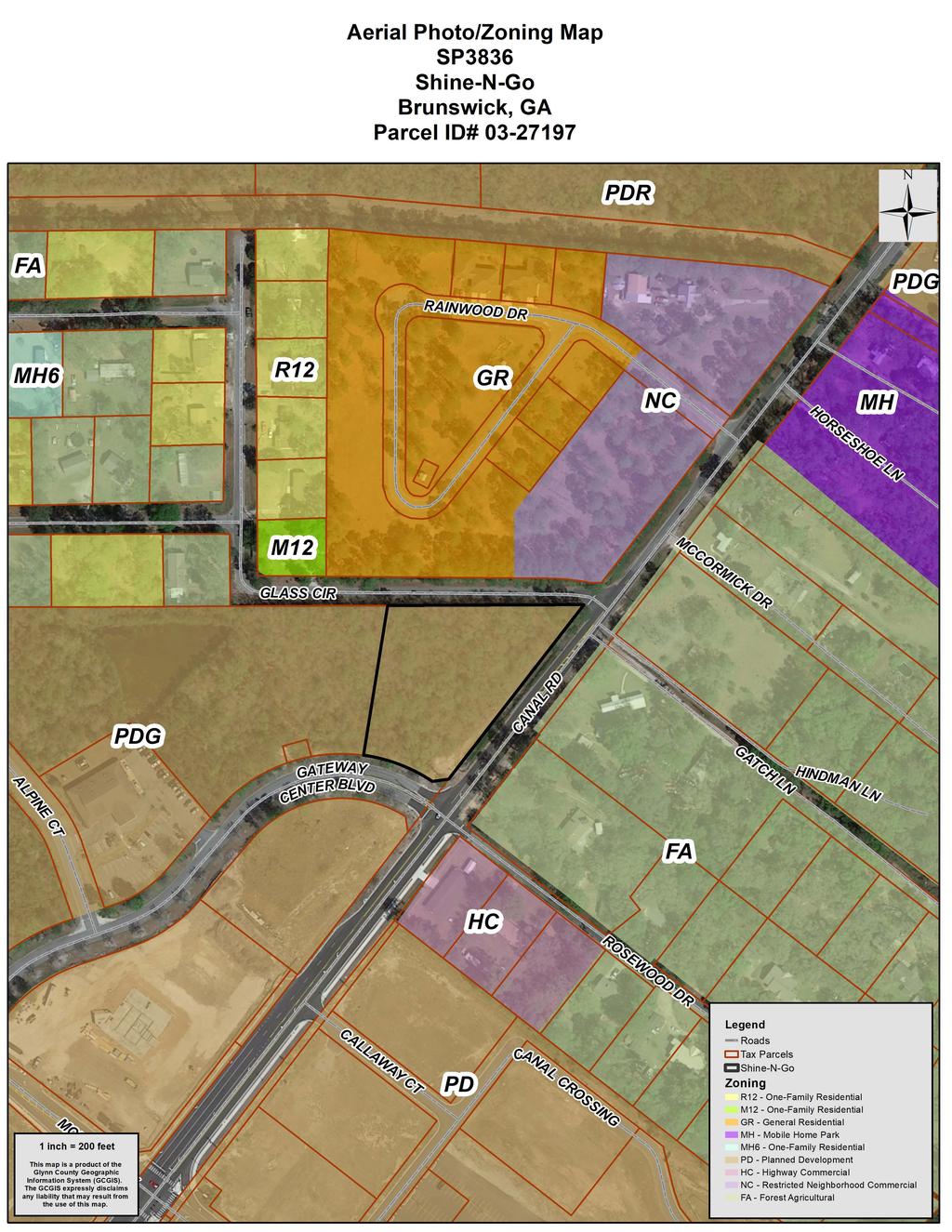
1 COMMUNITY DEVELOPMENT DEPARTMENT Planning and Zoning Division 1725 Reynolds Street, Suite 200, Brunswick, GA Phone: /Fax: MAINLAND PLANNING COMMISSION STAFF REPORT August 7, 2018 Application Type Site Plan Case Number SP3836 Applicant Joe Fendig, GTI Express, LLC Name of Project Shine N Go Property Address 515 Gateway Center Blvd Parcel ID Area of Property 1.74 acres Existing Zoning PDG, Gateway-Alpine PD (ZM3579) Existing Land Use Vacant and undeveloped Proposed Land Use Car wash Proposed Building(s) Size 5,662 SF CONTEXT: Project Description: Consider site plan approval for the construction of a new car wash in the Gateway Center subdivision. Background / Additional Information: The widening of Canal Road is an upcoming Glynn County project. The county will need to obtain the property s current 15 drainage easement from the owner for the project. Noticing Requirements: A public notice sign was posted on the property on July 24, Zoning District Standards: Min. Lot Size 6,000 SF Min. Lot Width 60 Setbacks From Gateway Center ROW 20 From Canal Road ROW 35 From Glass Circle ROW 20
2 FINDINGS: In conformance with the Glynn County Zoning Ordinance Section (a), the Planning Commission shall be guided by the following standards and criteria (staff comments in bold): 1. The application, site plan and other submitted information contain all the items required under this Section. This requirement has been met. 2. The proposed uses, buildings and structures are in accordance with the requirements of this Ordinance and other ordinances of Glynn County. The proposed use of a car wash is consistent with the permitted uses within the Gateway-Alpine PD. 3. Adequate provisions are made for ingress and egress, off-street parking, loading and the flow of traffic, which may reasonably be anticipated. Ingress/Egress Point(s): Parking Spaces Loading Spaces Required: 4 Required: 0 Provided: 7 Provided: 0 This requirement has been met. The applicant is providing an additional 3 parking spaces. 4. Adequate provisions are made to control the flow of storm water from and across the site. Proposed stormwater system: Flows for this site are accounted for in a downstream system. Water quality will be addressed with inlet filters, dry detention and other methods. Runoff will be directed to the Canal Road ditch. Site Coverage allowed (ZM3579): 80% Site Coverage proposed: 48.8% 5. Adequate provisions are made to protect trees that are selected to remain as depicted on the site plan. Trees to Remain: N/A Tree Credits Required: N/A Tree Credits Provided: N/A This requirement is not applicable. SP3836 Shine N Go 2 August 7, 2018 MPC Meeting
3 6. Adequate provisions are made to buffer intensive uses and to screen all service areas from view of the adjacent properties and streets. Buffer(s) Required: Section 613.3(2)(a) requires a type E buffer for commercial development located along streets where the public has access. A type E buffer is a vegetative buffer of not less than 10 feet. A type E buffer is required along Gateway Center Boulevard, Canal Road and Glass Circle. Section 613.3(3)(a) requires a type D buffer where trash collection and storage areas, dumpsters, and compactors are in view of a street where the public has access. A type D buffer consists of a landscape wall high enough to visually conceal the equipment. Buffers(s) Provided: A type E buffer will be provided along Gateway Center Boulevard, Canal Road and Glass Circle. A type D buffer concealing the dumpster area will be provided. 7. Adequate provisions are made to control the location, intensity and direction of all outdoor lighting so that it will not have an adverse effect upon adjoining properties. Staff comment: The applicant will comply with Section 622 (Exterior Lighting) of the zoning ordinance. 8. Open space, as required, has been provided and appropriate means are proposed to assure maintenance of common areas and facilities. Open Space Required: NA Open Space Provided: NA Proposed maintenance of common areas and facilities: None. Staff comment: This requirement is not applicable. 9. Adequate provisions are made for water supply, fire protection and sewage collection and treatment. Current/proposed water: JWSC Current/proposed sewer: JWSC Fire protection: Glynn County Staff comment: This requirement has been met. SP3836 Shine N Go 3 August 7, 2018 MPC Meeting
4 ACTIONS: Pursuant to Section 619.4(b) of the Glynn County Zoning Ordinance, the Planning Commission shall take one of the following actions: (i) Approve the site plan as presented; (ii) Approve the site plan with conditions. In approving a site plan the Planning Commission may impose conditions and restrictions so long as the intent of the Zoning Ordinance is carried out and the zoning district regulations established herein are not varied so as to make them less restrictive. If the Planning Commission so acts, then it shall specifically state those requirements which must be met before an applicant may be granted final site plan approval and a building permit. The applicant shall submit a site plan revised in accordance with the decision of the Planning Commission to the Community Development Department for approval before a building permit can be granted. The Community Development Director may elect to resubmit the plan to the Planning Commission for final approval; (iii) Defer action. When there are concerns about approval of a site plan, action may be deferred; (iv) Deny Approval; Approval of the site plan may be denied based upon findings that the proposed plan fails to comply with the requirements for approval. There shall be no waiting period required for submittal of a new site plan after a site plan has been denied, however it shall be considered a new application and shall be submitted with all required information and fees. RECOMMENDED MOTION: I move to approve application SP3836. AGENDA ITEM ATTACHMENTS: 1. Staff Report 2. Zoning / Aerial Map 3. Site Plan 4. Elevations 5. Review History SP3836 Shine N Go 4 August 7, 2018 MPC Meeting
5


6 15" RCP G E O R G I A SITE PLAN P E T E R No R EGI STER ED PROFESSIONAL E N GI N EE R S C H O E N A U E R LOCATION MAP NTS SITE SHINE N GO LOT 110 GATEWAY CENTER BRUNSWICK, GA OWNER / DEVELOPER: GTI EXPRESS, LLC 100 CART DRIVE ST. SIMONS ISLAND, GA (912) jfendig@gmail.com TIDEWATER ENGINEERING, INC PLANTATION CHASE, SUITE 14 ST. SIMONS ISLAND, GEORGIA PHONE (912) FAX (912) Signs: Signs shall meet the provisions of the Zoning Ordinance for signs located in Highway Commercial zoning districts with the following exceptions: Monument sign: One monument sign identifying the District and the major tenants within the District is allowed. The sign is permitted within the District adjacent to the intersection of Canal Road and Gateway Center Boulevard. The monument sign may be two sided with a maximum height of 35 feet, a maximum profile area of 600 square feet, and the maximum sign area of 400 square feet on each side. Free standing directory signs: One freestanding directory sign with the names of the tenants located on the parcel shall be allowed on each parcel with multiple tenants. These signs shall have a maximum height of 14 feet, a maximum profile area of 180 square feet and a maximum sign area of 80 square feet on each side. 16 8''W SS SS S SS SS SS OUTLOT C FM FM FM CURB INLET TOP = THROAT = INV. = 10.75(NE) INV. = 10.28(SW) INV. = 10.12(BOX) FM X X 8''W8''W FM FM FM FM FM FM 8" UNK SS SS SS SS SS SS SS SS FM FM FM X FM FM FM FM FM FM 8''W 18" RCP SD FM FM FM FM FM 8" UNK D FM FM FM FM 6" UNK CURB INLET TOP = FM FM FM FM FM FM FM NOW OR FORMERLY EXCHANGE ACCOMMODATION TITLEHOLDER V, LLC, EQUITY TRUST COMPANY CUSTODIAN FBO IRA, EQUITY TRUST COMPANY CUSTODIAN FBO IRA & EQUITY TRUST COMPANY CUSTODIAN FBO IRA 18" RCP THROAT = INV. = 11.41(SW) 6" UNK INV. = 11.08(BOX) STORM DRAIN MANHOLE 8''W8''W SD SD SD TOP = INV. = 9.92(SW) INV. = 10.05(SE) INV. = 9.77(NE) D 6" UNK 8''W FM FM 24" RCP SD SD INV.= LINE BEARING DISTANCE L1 S 81 46'46" W 28.77' CURVE RADIUS ARC LENGTH CHORD LENGTH CHORD BEARING C ' ' ' N 69 12'31" W SS SS SS SS SS SS SS SS SS SS SS SS SS SS SS SS SS 18" PN D SD SD SD SD NAIL IN PINE TREE SD SD 24" RCP FM FM 18.00' (NAVD-88) FM INV.= FM SURVEY REFERENCE: A. PLAT BY ROBERT N. SHUPE, GA. R.L.S. # 2224, TITLED "FINAL PLAT OF: GATEWAY CENTER BOULEVARD", DATED 8/28/95 AND RECORDED AT P.B. 23, PG B. PLAT BY ROBERT N. SHUPE, GA. R.L.S. # 2224, TITLED "PARCEL 'B', GATEWAY CENTER, GOLDEN ISLES GATEWAY TRACT", DATED 10/14/11. C. PLAT BY ROBERT N. SHUPE, GA. R.L.S. # 2224, TITLED "EXPEDITED PLAT OF: OUTLOT A & OUTLOT C, CANAL CROSSING", DATED 4/25/16, REVISED LAST ON 6/16/16, RECORDED AT P.B. 33, PG VERTICAL DATUM IS NAVD-88 AND WAS ESTABLISHED BY RTK-GPS TECHNOLOGY USING A TRIMBLE 5800 RECEIVER AND EGPS SOLUTIONS. INV.= " RCP SD SD SD SD SCALE: 1" = 30' INV.= SHINE N GO REVISED PER COUNTY COMMENTS PSS DESCRIPTION REV. DATE: DRAWN: APPROVED: DATE: MOVE LS BUFFER OUT OF DRAINAGE EASEMENT ALONG CANAL PSS RD. PROJ#: SCALE: GATEWAY CENTER BLVD pss AS SHOWN SHEET pss 1 OF 1 SITE PLAN
7

8 GLYNN COUNTY COMMUNITY DEVELOPMENT REVIEW HISTORY- Last Review Only per ReviewType for SP3836 Shine-N-Go as of 07/30/2018 2:27 pm Review # Assigned To Result Result By Completed Planners Pre-Review 1 Keller Compliant Keller 07/09/ Resubmit 1 Keller Compliant Postal 07/25/ Drainage 2 Vicent Compliant Vicent 07/30/ Engineering 3 Culbreath Compliant Culbreath 07/30/ Fire Department 1 Johnson Compliant Johnson 07/10/ GIS Address 1 Newton Compliant With Comments Newton 07/09/2018 Based on the access shown, the address for this site will be 515 Gateway Center Blvd. Please include the address on the site plan. GIS Mapping 1 Proper Compliant With Comments Proper 07/10/2018 This project will be compliant when the current FEMA Firm panel suffix is shown on the plat. The information submitted on has been entered into the data base. JWSC 1 Cornely Compliant Cornely 07/10/2018 Site Plan Review updated to 'OK.' Details: 1. Submit construction drawings for review 2. Submit oil/water/sand separator design & capacity criteria and shop drawings for review by Pretreatment Coordinator 3. Use of a private well to supply water for the facilty - water must be metered for billing purposes 4. Pay Site Plan Review fee (mailed 7/10/18) Planning and Zoning 2 Leif Compliant Postal 07/25/ Traffic 1 Vicent Compliant With Comments Vicent 07/23/2018 Glynn County is currently planning the widening of Canal Road and would like to discuss acquiring the 15' drainage easement for right-of-way purposes. Print Date: 7/30/2018 Page 1 of 1
PLANNING COMMISSION STAFF REPORT
 COMMUNITY DEVELOPMENT DEPARTMENT Planning and Zoning Division 1725 Reynolds Street, Suite 200, Brunswick, GA 31520 Phone: 912-554-7428/Fax: 1-888-252-3726 PLANNING COMMISSION STAFF REPORT DATE: January
Minor Revision to Amend an Existing PD (Rezoning) RLF Kingsland Properties, LLC R-4 Tract Golden Isles Gateway Planned Development
 RLF Kingsland Properties, LLC R-4 Tract Golden Isles Gateway Planned Development") COMMUNITY DEVELOPMENT DEPARTMENT Planning and Zoning Division 1725 Reynolds Street, Suite 200, Brunswick, GA 31520 Phone: 912-554-7428/Fax: 1-888-252-3726 MAINLAND PLANNING COMMISSION STAFF REPORT MEETING
COMMUNITY DEVELOPMENT DEPARTMENT Planning and Zoning Division 1725 Reynolds Street, Suite 200, Brunswick, GA 31520 Phone: 912-554-7428/Fax: 1-888-252-3726 MAINLAND PLANNING COMMISSION STAFF REPORT MEETING
5970 Golden Isles Parkway (Bergen Woods) Property Address. Planned Development (PD) Golden Isles Gateway Tract (GC-16-00) Existing Land Use
 Property Address. Planned Development (PD) Golden Isles Gateway Tract (GC-16-00) Existing Land Use") COMMUNITY DEVELOPMENT DEPARTMENT Planning and Zoning Division 125 Reynolds Street, Suite 200, Brunswick, GA 31520 Phone: 912-554-428/Fax: 1-888-252-326 BOARD OF COMMISSIONERS STAFF REPORT MEETING DATE:
COMMUNITY DEVELOPMENT DEPARTMENT Planning and Zoning Division 125 Reynolds Street, Suite 200, Brunswick, GA 31520 Phone: 912-554-428/Fax: 1-888-252-326 BOARD OF COMMISSIONERS STAFF REPORT MEETING DATE:
TO: Glynn County Islands Planning Commission. Karl W. Bursa, AICP, Planner II. PP3105 Stillwater Phase III. DATE: November 10, 2015
 COMMUNITY DEVELOPMENT DEPARTMENT Planning and Zoning Division 1725 Reynolds Street, Suite 200, Brunswick, GA 31520 Phone: 912-554-7428/Fax: 1-888-252-3726 TO: Glynn County Islands Planning Commission FROM:
APPLICANT: Brunswick & Glynn County Development Authority, owner.
 GLYNN COUNTY BOARD OF COMMISSIONERS MEMO TO: Glynn County Mainland Planning Commission 701 G Street Brunswick, Georgia 31520 Phone: (912) 554-7400 Fax: (912) 554-7596 FROM: SUBJECT: Eric Landon, Planner
GLYNN COUNTY BOARD OF COMMISSIONERS OFFICE OF COMMUNITY DEVELOPMENT
 GLYNN COUNTY BOARD OF COMMISSIONERS OFFICE OF COMMUNITY DEVELOPMENT 1725 Reynolds Street - Suite 200 - Brunswick, Georgia 31520-6435 Phone: (912) 554-7428 MEMO TO: Glynn County Mainland Planning Commission
TO: Glynn County Mainland Planning Commission. Eric Lee Johnson, Planning Division Manager. PP2944 McKenzie Gardens. DATE: November 20, 2014
 MEMO COMMUNITY DEVELOPMENT DEPARTMENT Planning and Zoning Division 1725 Reynolds Street, Suite 200, Brunswick, GA 31520 Phone: 912-554-7428/Fax: 1-888-252-3726 TO: Glynn County Mainland Planning Commission
TO: Glynn County Board of Commissioners. Eric Landon, Planner II. ZM2773 Peppertree Crossing Phase II
 COMMUNITY DEVELOPMENT DEPARTMENT Planning and Zoning Division 1725 Reynolds Street, Suite 200, Brunswick, GA 31520 Phone: 912-554-7428/Fax: 1-888-252-3726 TO: Glynn County Board of Commissioners MEMO FROM:
COMMUNITY DEVELOPMENT DEPARTMENT
 COMMUNITY DEVELOPMENT DEPARTMENT Planning and Zoning Division 1725 Reynolds Street, Suite 200, Brunswick, GA 31520 Phone: 912-554-7428/Fax: 1-888-252-3726 PLANNING COMMISSION STAFF REPORT DATE June 12,
TO: Glynn County Islands Planning Commission. Eric Landon, Planner II. PP2754 Stones Throw Cottages. DATE: February 6, 2014
 COMMUNITY DEVELOPMENT DEPARTMENT Planning and Zoning Division 1725 Reynolds Street, Suite 200, Brunswick, GA 31520 Phone: 912-554-7428/Fax: 1-888-252-3726 TO: Glynn County Islands Planning Commission FROM:
Residential Major Subdivision Review Checklist
 Residential Major Subdivision Review Checklist Plan Submittal Requirements: 2 full sets of stamped plans Electric submittal - all plans contained in a single PDF 3 full sets if commercial kitchen or dining
M E M O R A N D U M. Meeting Date: October 23, Item No. F-1. Planning and Zoning Commission. Daniel Turner, Planner I
 M E M O R A N D U M Meeting Date: October 23, 2017 Item No. F-1 To: From: Subject: Planning and Zoning Commission Daniel Turner, Planner I PUBLIC HEARING: Consider a recommendation of a of Planned Development
FINAL SUBDIVISION AND LAND DEVELOPMENT PLAN CHECKLIST. Plan Name. Applicant's Name:
 TOWNSHIP OF UPPER ST. CLAIR FINAL SUBDIVISION AND LAND DEVELOPMENT PLAN CHECKLIST Date Filed Plan Name PLC Applicant's Name: Phone Filing Date for Final Application Final Plat 114.22. FINAL APPLICATION
Planning Department Oconee County, Georgia
 Planning Department Oconee County, Georgia STAFF REPORT REZONE CASE #: 6985 DATE: October 31, 2016 STAFF REPORT BY: Andrew C. Stern, Planner APPLICANT NAME: Williams & Associates, Land Planners PC PROPERTY
McGowin Park, LLC. B-3, Community Business District
 # 10, 11, 12 SUB2014-00024 ZON2014-00500 ZON2014-00501 SUBDIVISION, PLANNED UNIT DEVELOPMENT (East), PLANNED UNIT DEVELOPMENT (West) STAFF REPORT Date: April 3, 2014 DEVELOPMENT NAME LOCATION McGowin Park,
Department of Planning & Development Services
 Department of Planning & Development Services S T A F F R E P O R T February 9, 2015 CASE NO: PROJECT: EXECUTIVE SUMMARY: ZA14-154 Plat Revision for Lots 25R-1A, 25R-1B and 25R-1C, Block 1, Woodland Heights
Residential Minor Subdivision Review Checklist
 Residential Minor Subdivision Review Checklist Plan Submittal Requirements: 2 full sets of stamped plans Electric submittal - all plans contained in a single PDF 3 full sets if commercial kitchen or dining
SUBDIVISION AND LAND DEVELOPMENT. 185 Attachment 20
 185 Attachment 20 APPENDIX S Plat No. Date of Submission Twp. Fee $ Dauphin Co. Fee $ TOWNSHIP OF DERRY SUBDIVISION OR LAND DEVELOPMENT PLAN SUBMISSION APPLICATION This block for Twp. use only 1. Title
ARTICLE 900 PLAT AND PLAN REQUIREMENTS
 ARTICLE 900 PLAT AND PLAN REQUIREMENTS SEC. 900.1 ITEMS TO BE SHOWN ON PLAT OR PLAN General (1) Property lines of all property owners adjacent to the exterior boundaries of the project shall be located
BOSSIER CITY PARISH METROPOLITAN PLANNING COMMISSION 620 Benton Rd. Bossier City, LA Phone: Fax: PRELIMINARY PLAT
 (OFFICE USE ONLY) Application Fee: Paid: Date: CASE # Project Information BOSSIER CITY PARISH METROPOLITAN PLANNING COMMISSION 620 Benton Rd. Bossier City, LA 71111 Phone: 318-741-8824 Fax: 318-741-8827
E L M E R B O R O U G H L A N D U S E B O A R D APPLICATION COVER SHEET (to be completed for all applications and appeals)
") E L M E R B O R O U G H L A N D U S E B O A R D APPLICATION COVER SHEET (to be completed for all applications and appeals) 1. Name(s): 2. Address: 3. Telephone Number(s): 4. E-mail: 5. Owner Name(s) (if
E L M E R B O R O U G H L A N D U S E B O A R D APPLICATION COVER SHEET (to be completed for all applications and appeals) 1. Name(s): 2. Address: 3. Telephone Number(s): 4. E-mail: 5. Owner Name(s) (if
Final Plat Mapping Requirements
 CURRENT PLANNING DIVISION 410 E. 5 th Street Loveland, CO 80537 970-962-2523 eplan-planning@cityofloveland.org cityofloveland.org/dc Final Plat Mapping Requirements All Final plats shall comply with the
Township of Collier 2418 Hilltop Road Presto, PA 15142
 Township of Collier 2418 Hilltop Road Presto, PA 15142 Fees: Major: 2 checks $600 + $50 per lot & $1700 Escrow) APPLICATION FOR SUBDIVISION major FINAL only Plans must be folded Rolled plans will not be
Township of Little Egg Harbor Planning Board 665 Radio Road Little Egg Harbor, New Jersey Phone: ext. 221 Fax:
 BLOCK(S) LOT(S) Township of Little Egg Harbor Planning Board 665 Radio Road Little Egg Harbor, New Jersey 08087 Phone: 609-296-7241 ext. 221 Fax: 609-294-3040 Development Application Amended Development
PLANNED DEVELOPMENT DISTRICT STANDARDS. Cadence Site
 PLANNED DEVELOPMENT DISTRICT STANDARDS Cadence Site A Planned Development District 1. Statement of General Facts, Conditions and Objectives Property Size: Approximately 57.51 Acres York County Tax Map
TO: Glynn County Mainland Planning Commission. Iris M Thielen Johnston, AICP, Planner III. ZM2459 Planting Hammock. DATE: September 24, 2012
 MEMO COMMUNITY DEVELOPMENT DEPARTMENT Planning and Zoning Division 1725 Reynolds Street, Suite 200, Brunswick, GA 31520 Phone: 912-554-7428/Fax: 1-888-252-3726 TO: Glynn County Mainland Planning Commission
MINOR SUBDIVISION PLAT CHECKLIST
 MINOR SUBDIVISION PLAT CHECKLIST Project Name: Tax ID #: Project Number: Date: _ Reviewed By: Telephone: NOTES: All lots on septic systems must comply with the Fulton County Health Department requirements
ARTICLE 900 PLAT AND PLAN REQUIREMENTS
 Final SEC. 900.01 ARTICLE 900 PLAT AND PLAN REQUIREMENTS General provisions. (a) Scale. The scale of all plats and plans shall be a minimum of 1 to 100 ft. (b) Size. The minimum page size for all plats
Subdivision of existing two lots into three lots.
 PP-15-00189 Item No. 4-1 PC Staff Report 06/22/2015 PLANNING COMMISSION REPORT NON PUBLIC HEARING ITEM PUBLIC HEARING ON THE VARIANCE ONLY ITEM NO 4: PRELIMINARY PLAT FOR DEERFIELD WOODS SUBDIVISION NO.
CONSTRUCTION PLANS for HALCYON A RESIDENTIAL SUBDIVISION 6100 MIDNIGHT PASS ROAD, SARASOTA, FL 34242
 CONSTRUCTION PLANS for HALCYON A RESIDENTIAL SUBDIVISION 6100 MIDNIGHT PASS ROAD, SARASOTA, FL 34242 SECTION 18, TOWNSHIP 37 SOUTH, RANGE 18 EAST SARASOTA COUNTY, FLORIDA PID: 0030001 A DEVELOPMENT BY
SUBDIVISION APPLICATION
 SUBDIVISION APPLICATION Preliminary Plat Minor Plat Final Plat Amended Plat Applicant Name: Owner (if different from applicant) Name: Company: Company: Address: Address: City, State, Zip City, State, Zip
ABBREVIATION LEGEND SITE INFORMATION:
 SITE INFORMATION: Current Zone: R-3 PUD, governed by Fox Hollow 2nd MDA Basis of Elevations: Northeast Corner of Section 13, T6S, R1W, S.L.B. & M Elevation: 4599.26 (Benchmark) ABBREVIATION LEGEND Owners:
ARTICLE XVI SUBDIVISION DEVELOPMENT
 ARTICLE XVI SUBDIVISION DEVELOPMENT 16.0 The division of land into 4 or more lots that will require the construction or extension of public streets, water or sanitary sewerage (other than the direct connection
Applications will be received on business days between 9:00 AM and 3:00 PM
 Special Use Permit Application Douglas County Board of Commissioners Douglas County, Georgia Applications will be received on business days between 9:00 AM and 3:00 PM Date of Application: Application
PLANNED UNIT DEVELOPMENT (East), PLANNED UNIT DEVELOPMENT (West) STAFF REPORT Date: September 18, 2014
, PLANNED UNIT DEVELOPMENT (West) STAFF REPORT Date: September 18, 2014") PLANNED UNIT DEVELOPMENT (East), PLANNED UNIT DEVELOPMENT (West) STAFF REPORT Date: September 18, 2014 DEVELOPMENT NAME LOCATION McGowin Park, LLC PLANNED UNIT DEVELOPMENT (East) 1401 Satchel Paige Drive
PLANNED UNIT DEVELOPMENT (East), PLANNED UNIT DEVELOPMENT (West) STAFF REPORT Date: September 18, 2014 DEVELOPMENT NAME LOCATION McGowin Park, LLC PLANNED UNIT DEVELOPMENT (East) 1401 Satchel Paige Drive
Site Plan Application
 Site Plan Application City of St. Pete Beach Community Development Department 155 Corey Avenue St. Pete Beach, Florida 33706 (727) 367-2735 www.stpetebeach.org Case Number: PROPERTY OWNER: Name: Address:
MIDWAY CITY Planning Office 75 North 100 West Phone: x105 Midway, Utah Fax:
 MIDWAY CITY Planning Office 75 North 100 West Phone: 435-654-3223 x105 Midway, Utah 84049 Fax: 435-654-2830 mhenke@midwaycityut.org Preliminary/ Final Application for Small Scale Subdivision Application
WESTMINSTER PARK SUBDIVISION
 WESTMINSTER PARK SUBDIVISION Engineering Comments: FINAL PLAT COMMENTS (should be addressed prior to submitting the FINAL PLAT for review and/or signature by the City Engineer): A. Provide all of the required
TOWN OF LEWISTON PLANNING BOARD APPLICATION
 TOWN OF LEWISTON PLANNING BOARD APPLICATION DESCRIPTION OF PROPOSED REQUEST: Name of Property Owner: Phone #: Name of Applicant:Phone #: Address or Location of Proposal:_SBL# Size of Parcel or Structure:Existing
The Filing Fee for a Minor Plat is $ PLUS $20.00 per lot created
 DEPARTMENT OF COMMUNITY DEVELOPMENT MINOR PLAT PROCEDURE The Filing Fee for a Minor Plat is $250.00 PLUS $20.00 per lot created Description: The purpose of a Minor Plat is to allow property to be platted
PRELMINARY PLAT CHECKLIST
 PRELMINARY PLAT CHECKLIST A. All preliminary plat submitted for approval shall be prepared by a Registered Professional Land Surveyor. B. Preliminary plats must be drawn to a scale of XXX with such accuracy
701 G Street Brunswick, Georgia Phone: (912) Fax: (912)
 Fax: (912)") GLYNN COUNTY BOARD OF COMMISSIONERS MEMO TO: Glynn County Mainland Planning Commission 701 G Street Brunswick, Georgia 31520 Phone: (912) 554-7400 Fax: (912) 554-7596 FROM: SUBJECT: Eric Landon, Planner
GLYNN COUNTY BOARD OF COMMISSIONERS MEMO TO: Glynn County Mainland Planning Commission 701 G Street Brunswick, Georgia 31520 Phone: (912) 554-7400 Fax: (912) 554-7596 FROM: SUBJECT: Eric Landon, Planner
FINAL PLAT CHECKLIST
 FINAL PLAT CHECKLIST Project Name: Tax ID #: Project Number: Date: _ Reviewed By: Telephone: Please address all items marked with an "X" Please return redline comments with corrected plan, original mylar,
Glynn County Mainland Planning Commission. Karl Bursa, AICP, Planner II. DATE: August 26, CURRENT ZONING: PD Planned Development
 COMMUNITY DEVELOPMENT DEPARTMENT Planning and Zoning Division 1725 Reynolds Street, Suite 200, Brunswick, GA 31520 Phone: 912-554-7428/Fax: 1-888-252-3726 TO: Glynn County Mainland Planning Commission
Application For Development Review (Subdivisions and Site Plan Review)
") Application For Development Review (Subdivisions and Site Plan Review) Thank you for your interest in Pickens County, South Carolina. This packet includes the necessary documents for review of subdivision
Application For Development Review (Subdivisions and Site Plan Review) Thank you for your interest in Pickens County, South Carolina. This packet includes the necessary documents for review of subdivision
PLANNING & ZONING DEPARTMENT 401 South Rogers Street Waxahachie, Texas (469)
") ZONING APPLICATION Select Application Type: Zoning Change Specific Use Permit (SUP) PD Concept Plan PD Detailed Plan PD Amendment Site Plan The following items shall be included in the application submittal:
ZONING APPLICATION Select Application Type: Zoning Change Specific Use Permit (SUP) PD Concept Plan PD Detailed Plan PD Amendment Site Plan The following items shall be included in the application submittal:
BRIDGETON SUBDIVISION APPLICATION CHECKLIST
 APPLICATION NAME AND # CHECKLIST COMPLETED BY: DATE: Signature and printed name BRIDGETON SUBDIVISION APPLICATION CHECKLIST TO SUBDIVISION APPLICANTS: The attached checklist is to assist you in the submission
MAJOR SUBDIVISION PRELIMINARY PLAT CHECKLIST
 TOWNSHIP OF EGG HARBOR PLANNING BOARD/ZONING BOARD OF ADJUSTMENT 3515 BARGAINTOWN ROAD EGG HARBOR TOWNSHIP, NJ 08234 MAJOR SUBDIVISION PRELIMINARY PLAT CHECKLIST The following checklist is designed to
ZONING AMENDMENT, PLANNED UNIT DEVELOPMENT & SUBDIVISION STAFF REPORT Date: August 8, 2013
 ZONING AMENDMENT, PLANNED UNIT DEVELOPMENT & SUBDIVISION STAFF REPORT Date: August 8, 2013 NAME SUBDIVISION NAME PV-Magnolia, LLC Twelve Trees Subdivision LOCATION 2860, 2862 and 2866 Pleasant Valley Road
REPORT TO THE PLANNING COMMISSION
 Agenda Number: PC14-50 MEETING DATE: February 5, 2015 REPORT TO THE PLANNING COMMISSION SUBJECT: Villas of Tara Oaks Request approval of a Preliminary Subdivision Plat for 29 lots, on 9.14 acres located
FINAL PLAT APPLICATION
 FINAL PLAT APPLICATION (Page 1 of 3) LEGAL OWNER(s): NAME: STREET ADDRESS OWNER(s): CITY, STATE, ZIP CODE: PHONE NUMBER: BILLING ADDRESS: NAME OF ENGINEER/SURVEYOR: Engineer/Surveyor Address, Phone: PROPERTY
PLANNING COMMISSION REPORT Regular Agenda Public Hearing Item PRD TO RM15; ACRES; 2101 EXCHANGE CT (KES)
") PC Staff Report 7/22/15 Z-14-00515 Item No. 3-1 PLANNING COMMISSION REPORT Regular Agenda Public Hearing Item PC Staff Report 7/22/15 ITEM NO. 3 PRD TO RM15; 9.818 ACRES; 2101 EXCHANGE CT (KES) Z-14-00515:
PC Staff Report 7/22/15 Z-14-00515 Item No. 3-1 PLANNING COMMISSION REPORT Regular Agenda Public Hearing Item PC Staff Report 7/22/15 ITEM NO. 3 PRD TO RM15; 9.818 ACRES; 2101 EXCHANGE CT (KES) Z-14-00515:
Secondary Plat 2018 Bargersville Plan Commission Application Kit
 Secondary Plat 2018 Bargersville Plan Commission Application Kit For Commercial, Industrial, and Residential Subdivisions Step 1: Application The applicant must make an appointment with the Town Planner
Planning & Zoning Commission
 Planning & Zoning Commission Planning & Development Department August 14, 01 Zoning Map Amendment MAP-1-0001 (Bay View Section 4) Request Rezone approximately 1.19 acres from OS (Open Space) to RSF- (Residential
STONE HEDGE SUBDIVISION, UNIT 1, RESUBDIVISION OF LOT 40 & WEST COMMON AREA
 # 5 SUB-000498-2018 STONE HEDGE SUBDIVISION, UNIT 1, RESUBDIVISION OF LOT 40 & WEST COMMON AREA Engineering Comments: Must comply with the Mobile County Flood Damage Prevention Ordinance. Development shall
610 LAND DIVISIONS AND PROPERTY LINE ADJUSTMENTS OUTSIDE A UGB
 ARTICLE VI: LAND DIVISIONS AND PROPERTY LINE ADJUSTMENTS VI-21 610 LAND DIVISIONS AND PROPERTY LINE ADJUSTMENTS OUTSIDE A UGB 610-1 Property Line Adjustments (Property Line Relocation) A property line
SECTION 6 - APPROVAL OF PLATS. Whenever any subdivision of land is proposed, and before any permit for the
 SECTION 6 - APPROVAL OF PLATS 6-1 APPROVAL REQUIRED BEFORE SALE Whenever any subdivision of land is proposed, and before any permit for the erection of a structure shall be granted, the subdivider or his
SUBJECT PARCEL(S) Property Owner(s) TMS Number Approximate Acreage Carolina Park Development, LLC
 Property Owner(s) TMS Number Approximate Acreage Carolina Park Development, LLC") Staff Report Special Planning Commission Meeting November 19, 2014 For reference, the Zoning Code and Land Development Regulations are available online. AGENDA ITEM 5c. SKETCH PLAN APPROVAL REQUEST: Request
Staff Report Special Planning Commission Meeting November 19, 2014 For reference, the Zoning Code and Land Development Regulations are available online. AGENDA ITEM 5c. SKETCH PLAN APPROVAL REQUEST: Request
PLAT OF SURVEY VICINITY MAP (NOT TO SCALE) N N W E SITE BENCHMARK # 2 W E N&D ON BACK OF CURB NAVD 88 S S 0' 10' 20' 40' 60' 1" = 20' TOP=106.7
 N N W E SITE BENCHMARK # 2 W E N&D ON BACK OF CURB NAVD 88 S S 0' 10' 20' 40' 60' 1 = 20' TOP=106.7") PLAT OF SURVEY VICINITY MAP (NOT TO SCALE) N N W E SITE BENCHMARK # 2 W E N&D ON BACK OF CURB 106.21 NAVD 88 S S 0' 10' 20' 40' 60' 1" = 20' TOP=106.72 N INV PVC=99.27 S INV PVC=99.32 E INV CLAY=99.39
PLAT OF SURVEY VICINITY MAP (NOT TO SCALE) N N W E SITE BENCHMARK # 2 W E N&D ON BACK OF CURB 106.21 NAVD 88 S S 0' 10' 20' 40' 60' 1" = 20' TOP=106.72 N INV PVC=99.27 S INV PVC=99.32 E INV CLAY=99.39
PLANNING COMMISSION. Agenda Item # 8.
 PLANNING COMMISSION Agenda Item # 8. CASE SUMMARY Street Closure Planning Commission February 1, 2016 SC-1-217 Jeff Walton, 341-3260, jeff.walton@wilmingtonnc.gov Staff recommendation APPROVAL Planning
Section Preliminary Plat Checklist and Application Forms
 Section 201 - Preliminary Plat Checklist and Application Forms PRELIMINARY SUBDIVISION PLAT REVIEW PROCESS CHART PRELIMINARY SUBDIVISION PLAT APPLICATION PRELIMINARY PLAT REVIEW CHECKLIST CITY OF NAMPA
Cover Letter with Narrative Statement
 Cover Letter with Narrative Statement March 31, 2017 rev July 27, 2017 RE: Rushton Pointe Residential Planned Unit Development Application for Public Hearing for RPUD Rezone PL2015 000 0306 Mr. Eric Johnson,
Waseca County Planning and Zoning Office
 Waseca County Planning and Zoning Office 300 North State Street Waseca, Minnesota 56093 Phone: 507-835-0650 Fax: 507-837-5310 Form no. PZ 081009 Web Site: www.co.waseca.mn.us FEES: 1) CUP FEE- $400.00
ARTICLE IV: DEVELOPMENT STANDARDS
 ARTICLE IV: DEVELOPMENT STANDARDS IV-53 409 PRIVATE STREETS A private street means any way that provides ingress to, or egress from, property by means of vehicles or other means, or that provides travel
CITY OF LEE S SUMMIT MINOR PLAT PROCESS. Purpose of Minor Plats
 MINOR PLAT PROCESS Purpose of Minor Plats The City of Lee s Summit requires that all property be platted before a building permit is issued. Platting involves the subdivision of land into lots or tracts.
DIVISION 2 - CONSTRUCTION PLAN AND MISCELLANEOUS REQUIREMENTS
 DIVISION 2 - CONSTRUCTION PLAN AND MISCELLANEOUS REQUIREMENTS 2.1 Required Plan Sheets 2.2 Drawing Requirements 2.3 Graphic Standards 2.4 Easements 2.5 Utility Locations 2.6 Private Facility Locations
Residential Subdivision Preliminary Plat Application
 WATER MODELING FEES Major : $650 or Minor : $550 # of lots x $35 per lot Residential Preliminary Plat Application Lots: 1-9 10-19 20-49 50-99 100-199 $300 $400 $475 $625 $825 200-349 350-499 500-499 700-999
To provide for the review of the final engineering plans, the subdivision improvement agreement, public dedications, and other legal agreements.
 ARTICLE 5 FINAL PLAT 501 Intent DOUGLAS COUNTY SUBDIVISION RESOLUTION To provide for the review of the final engineering plans, the subdivision improvement agreement, public dedications, and other legal
PRELIMINARY PLAT CHECK LIST
 PRELIMINARY PLAT CHECK LIST Name of Proposed Subdivision: The following items must be included with the initial submittal of a Preliminary Plat: Application, filled out completely Project Narrative Pre-application
LAND USE APPLICATION
 Lincoln County Department of Planning & Development 210 SW 2nd Street, Newport, OR 97365 Phone (541) 265-4192 Fax (541) 265-6945 LAND USE APPLICATION TO BE COMPLETED BY STAFF Conditional Use Non-Conforming
CHAPTER 22 SUBDIVISION AND LAND DEVELOPMENT
 CHAPTER 22 SUBDIVISION AND LAND DEVELOPMENT 22-101. Title 22-102. Legislative Intent Part 1 General Provisions 22-201. Development Permits Part 2 Administration 22-301. Fee Schedule Part 3 Fee Schedule
ELIZA JORDAN CORNER SUBDIVISION
 ELIZA JORDAN CORNER SUBDIVISION Engineering Comments: Must comply with the Mobile County Flood Damage Prevention Ordinance. Development shall be designed to comply with the storm water detention and drainage
Use permitted by: Right Special Exemption
 CENTER TOWNSHIP 150 Henricks Road Butler, PA 16001-8472 Phone (724) 282-7805 Fax (724) 282-6550 Application Number: FEE COLLECTED: Application for: Preliminary Final Land Development Location: Map and
APPLICATION SUBMITTAL REQUIREMENTS FOR Tentative Parcel or Subdivision Maps
 CITY OF EL CERRITO Community Development Department Planning and Building Division 10890 San Pablo Avenue, El Cerrito, CA 94530 (510) 215-4330 FA (510) 233-5401 planning@ci.el-cerrito.ca.us APPLICATION
Application for Preliminary Plat Checklist
 Application for Preliminary Plat Checklist Note: No portion of an existing parcel may be sold or transferred to another party without first legally subdividing the property according to the City of Richmond
SUBMITTAL REQUIREMENTS: The number indicates the number of copies for submittal (if applicable).
.") Office Use Only Preliminary Long Plat Long Subdivision Applicant Checklist PLANNING, COMMUNITY, & ECONOMIC DEVELOPMENT DEPARTMENT PRELIMINARY LONG PLAT LONG SUBDIVISION CHECKLIST Mailing Address: P.O.
Office Use Only Preliminary Long Plat Long Subdivision Applicant Checklist PLANNING, COMMUNITY, & ECONOMIC DEVELOPMENT DEPARTMENT PRELIMINARY LONG PLAT LONG SUBDIVISION CHECKLIST Mailing Address: P.O.
APPLICATION for MINOR SUBDIVISION REVIEW for CONCEPT and FINAL PLAT within COALVILLE CITY. Project Name: Project Address or Area: Name of Owner:
 APPLICATION for MINOR SUBDIVISION REVIEW for CONCEPT and FINAL PLAT within COALVILLE CITY For Office Use Only: Application #: Application Date: PC Approval Date: CC Approval Date: Community Development
PORT CITY COMMERCE PARK SUBDIVISION
 # 4 SUB2015-00019 PORT CITY COMMERCE PARK SUBDIVISION Engineering Comments: Must comply with the Mobile County Flood Damage Prevention Ordinance. Development shall be designed to comply with the storm
Planning and Zoning Commission STAFF REPORT
 TO: FROM: Planning and Zoning Commission STAFF REPORT CASA GRANDE PLANNING AND ZONING COMMISSION James Gagliardi, AICP, City Planner MEETING DATE: September 1, 2016 REQUEST AGENDA # Request by Marshall
PRIMUS TRACT MOUNT PLEASANT, SOUTH CAROLINA
 DEVELOPMENT GUIDELINES FOR PRIMUS TRACT MOUNT PLEASANT, SOUTH CAROLINA Date February 18, 2015 PLANNING COMMISSION SUBMITTAL Owner/Developer: American Star Development SC, LLC P.O. Box 211 Sullivans Island,
CHAPTER 26 PLANNING AND ZONING ARTICLE VII. MOBILE HOMES AND RECREATIONAL VEHICLE (RV) PARKS. Recreational Vehicle (RV) Park Development Standards
 PARKS. Recreational Vehicle (RV) Park Development Standards") CHAPTER 26 PLANNING AND ZONING ARTICLE VII. MOBILE HOMES AND RECREATIONAL VEHICLE (RV) PARKS. Section 26-VII-1. Section 26-VII-2. Section 26-VII-3. Section 26-VII-4. Section 26-VII-5. Purpose Permitted
CHAPTER 26 PLANNING AND ZONING ARTICLE VII. MOBILE HOMES AND RECREATIONAL VEHICLE (RV) PARKS. Section 26-VII-1. Section 26-VII-2. Section 26-VII-3. Section 26-VII-4. Section 26-VII-5. Purpose Permitted
PLANNED UNIT DEVELOPMENT & SUBDIVISION STAFF REPORT Date: November 17, 2016
 PLANNED UNIT DEVELOPMENT & SUBDIVISION STAFF REPORT Date: November 17, 2016 DEVELOPMENT NAME SUBDIVISION NAME LOCATION Autonation Ford of Mobile Autonation Ford of Mobile Subdivision 901, 909, and 925
QUEBEC STREET EAST 130TH AVENUE ONEIDA STREET E. 130TH AVE. VALENTIA ST TAMARAC ST EAST 128TH AVENUE MONACO STREET BACHMAN DR. SITE QUINCE ST.
 SHEET OF CASE NO.: SUBA 0-0 PURPOSE STATEMENT: THIS PLAT IS INTENDED TO SUBDIVIDE. ACRES INTO 0 SINGLE FAMILY LOTS, AND TRACTS FOR PARKS, OPEN SPACE, DRAINAGE AND DETENTION, DEDICATE RIGHT-OF-WAY AND GRANT
QUEBEC STREET EAST 130TH AVENUE ONEIDA STREET E. 130TH AVE. VALENTIA ST TAMARAC ST EAST 128TH AVENUE MOACO STREET BACHMAN DR. SITE QUINCE ST.
 SHEET OF CASE NO.: SUBA - PURPOSE STATEMENT: THIS PLAT IS INTENDED TO SUBDIVIDE. ACRES INTO SINGLE FAMILY LOTS, AND TRACTS FOR PARKS, OPEN SPACE, DRAINAGE AND DETENTION, DEDICATE RIGHT-OF-WAY AND GRANT
Department of Development Services Engineering; Survey Plat Review Group SPRG
 Department of Development Services Engineering; Survey Plat Review Group SPRG CITY OF DALLAS LEGAL DESCRIPTION PREPARATION GUIDELINE AND CHECKLIST The following guideline and checklist are provided to
LYON COUNTY COMMUNITY DEVELOPMENT DEPARTMENT
 LYON COUNTY COMMUNITY DEVELOPMENT DEPARTMENT B UILDING D EVELOPMENT E NGINEERING P LANNING 27 S. MAIN S TREET Y ERINGTON, NEVADA 89447 (775) 463-6591 F AX: (775) 463-5305 34 LAKES B OULEVARD D AYTON, NEVADA
RIVERDALE CITY PLANNING COMMISSION APPLICATION FOR RESIDENTIAL SUBDIVISION SITE PLAN APPROVAL
 Community Development 4600 So. Weber River Drive Riverdale, Utah 84405 RIVERDALE CITY PLANNING COMMISSION APPLICATION FOR RESIDENTIAL SUBDIVISION SITE PLAN APPROVAL CASE NO: DATE SUBMITTED: APPLICANT S
Time Extension Staff Report
 Time Extension Staff Report Subdivision Name Lunara Subdivision File Number SUB07-00019 Approval Time Extension for Lead Agency Boise City Certification Signature of Boise City Engineer Annexation Date
CERTIFIED SURVEY MAP
 SCONSIN STATE PLANE N:389676.12 E:2130390.15 Center of Section 23 CERTIFIED SURVEY MAP 734.06' THE (PRITCHETTE) ORIGINAL PLAT OF ALL IN THE NW 1 4 OF THE SE 1 4 OF FRACTIONAL SECTION 23, T7N, R9E, IN THE
UPPER MOUNT BETHEL TOWNSHIP NORTHAMPTON COUNTY, PENNSYLVANIA
 UPPER MOUNT BETHEL TOWNSHIP NORTHAMPTON COUNTY, PENNSYLVANIA JOINDER DEED / LOT CONSOLIDATION TOWNSHIP REVIEW PROCESS When accepting proposed Joinder Deeds / Lot Consolidations, review the Joinder Deed
Oakland County Michigan Register of Deeds Plat Engineering, GIS, & Remonumentation Dept. Ph: (248) Fax (248)
 Fax (248)") Oakland County Michigan Register of Deeds Plat Engineering, GIS, & Remonumentation Dept. Ph: (248)-858-1447 Fax (248)-858-7466 Requirements Needed for Final Plat Approval No. General Requirements. 1 Routing
Oakland County Michigan Register of Deeds Plat Engineering, GIS, & Remonumentation Dept. Ph: (248)-858-1447 Fax (248)-858-7466 Requirements Needed for Final Plat Approval No. General Requirements. 1 Routing
DALLAS WATER UTILITIES WATER/WASTEWATER COVENANT
 DALLAS WATER UTILITIES WATER/WASTEWATER COVENANT Procedure for obtaining a water and wastewater covenant, water covenant, or wastewater covenant; Required for initial submittal: 1. One letter from the
APPENDIX B. SUBMISSION REQUIREMENTS
 Master Major Site Minor Site Landscape Section B.1 Table of /Plat Requirements Proposed or approved name of development, project, subdivision, and/or phase. Location, including township, county, and state.
CARROLL COUNTY BUREAU OF DEVELOPMENT REVIEW OFF-CONVEYANCE SUBMITTAL CHECKLIST AND REVIEW FEE SHEET NOTICE: INCOMPLETE SUBMITTALS WILL BE RETURNED
 CARROLL COUNTY BUREAU OF DEVELOPMENT REVIEW OFF-CONVEYANCE SUBMITTAL CHECKLIST AND REVIEW FEE SHEET An off-conveyance submittal shall include all items as specified in Section 103-7 of the Code of Public
GeoPoint 1403 E. 5th Avenue Tampa, Florida
 AIRPORT ROAD PINELAND P.R.D. SUBDIVISION - PHASE 1 DEDICATION: CERTIFICATE OF REVIEW BY SURVEYOR, CITY OF ORMOND BEACH DEDICATION: THIS IS TO CERTIFY THAT FORESTAR (USA) REAL ESTATE GROUP INC., A DELAWARE
STAFF REPORT. City of Ormond Beach Department of Planning. Exception for Outdoor Activity
 STAFF REPORT City of Ormond Beach Department of Planning DATE: March 7, 2019 SUBJECT: Lucky s Market, 101 East Granada Boulevard: Special Exception for Outdoor Activity APPLICANT: Wendy L. Petrillo-Rundle,
ROYAL VIEW DEVELOPMENT
 GRETNA BUILDING FOR LEASE ROYAL VIEW DEVELOPMENT PROPOSED RENDERING AVAILABLE FOR LEASE + + LEASE RATE AND AVAILABILITY MINIMUM SPACE: MAXIMUM SPACE: LEASE RATE: 1,162 SF 14,675 SF + + Retail building
Community Development
 Land Use Petition RZ-16-002 Date of Staff Recommendation Preparation: April 15, 2016 (CEL) Date of Planning Commission Recommendation: May 3, 2016 PROJECT LOCATION: DISTRICT/SECTION/LANDLOT(S): ACREAGE
Town of Cary, North Carolina Rezoning Staff Report 14-REZ-31 Cary Park PDD Amendment (Waterford II) Town Council Meeting January 15, 2015
 Town Council Meeting January 15, 2015") Town of Cary, North Carolina Rezoning Staff Report 14-REZ-31 Cary Park PDD Amendment (Waterford II) Town Council Meeting January 15, 2015 REQUEST To amend the Town of Cary Official Zoning Map by amending
Town of Cary, North Carolina Rezoning Staff Report 14-REZ-31 Cary Park PDD Amendment (Waterford II) Town Council Meeting January 15, 2015 REQUEST To amend the Town of Cary Official Zoning Map by amending
APPENDIX 7 SPECIAL NOTES FOR PLATS AND CONSTRUCTION PLANS
 APPENDIX 7 SPECIAL NOTES FOR PLATS AND CONSTRUCTION PLANS EASEMENT AND DRAINAGE STATEMENT TO BE PLACED ON PLANS AND ALL SUBDIVISION PLATS REQUIRING SOIL DRAINAGE MANAGEMENT PLANS The easements designated