Conceptual Review Agenda
|
|
|
- Anne Norton
- 5 years ago
- Views:
Transcription
1 Conceptual Review Agenda Schedule for 07/12/18 to 07/12/ Conference Room A Thursday, July 12, 2018 Time Project Name Applicant Info Project Description 9:30 Southridge Verizon WTE CDR Rescheduled to 8/16/2018 at 10:15am. Shawn Turk (720) turks@bv.com This is a request to install 6 new wireless antennas and ground support equipment at Southridge Gold Course (parcel # ). There is an existing driving range net pole at the location and it would be replaced with a new pole approximately 54 high to accommodate the antennas within a cannister. Ground equipment would be concealed within a 10 ½ x 19 ½ foot enclosure with siding to match existing buildings. The proposed project is within the Public Open Lands (POL) zone district and is subject to Administrative (Type 1) review. Planner DRC Clark Mapes Todd Sullivan 10:15 Ridgewood Hills 4th Filing David Kasprzak Replat (970) david@tfgdesign.com CDR This is a request to replat Ridgewood Hills Tract B at the intersection of Triangle Dr and Avondale Rd (parcel # ). The 5.19-acre site is currently approved for multi-family use and the applicant is requesting a change to 24 single-family lots. The site is currently undeveloped. The proposed project is within the Low-Density Mixed-Use (LMN) zone district with a small portion within the Medium-Density Mixed-Use (MMN) zone district and is subject to Administrative (Type 1) Review Planner DRC Ted Shepard Tenae Beane Agenda as of 06/28/18 at 4:01 pm Page 1 of 2
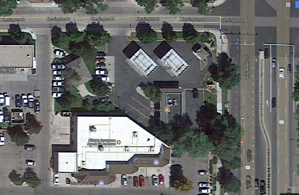
2 Thursday, July 12, 2018 Time Project Name Applicant Info Project Description 11:00 College & Kensington Drive-Thru CDR Cori Echevarria (720) This is a request to construct a drive-thru restaurant at the southwest corner of S College Ave and Kensington Dr (parcel # ). The proposal includes a 2,400-square foot building with 20 parking stalls. Primary site access would be taken from Kensington Dr to the north. The drive-thru lane runs interior to the site. The proposed project is within the General Commercial (CG) zone district and is subject to Planning and Zoning Board (Type 2) review. Planner DRC Pete Wray Brandy BH Agenda as of 06/28/18 at 4:01 pm Page 2 of 2


3 S Lemay Ave Compton Rd Taft Hill Lemay Timberline Southridge Golf Course Wireless Telecommunications Equipment Werner Elementary Vicinity Map Roma Valley Ct Highcastle Dr 287 Napa Valley Dr Roma Valley Dr «1 Milan Terrace Dr Belvedere Ct Douglas Belvedere Pl Pinnacle Pl Mountain Vista Oak Leaf Ct Seton St Southridge Golf Course Aerial Site Map Fairway Five Dr Fairway ix Dr S ^_^_^_ ^_ ^_ ^_^_^_ E Milan Terrace Dr Fossil Creek Pkwy LMN Skyway Dr Zoning Map Pinnacle Pl Southri dge Greens Hamilton Ct Yarnell Ct LMN Huntington Blvd Dearborn St Parliament Ct Portner Reservoir Seton St POL Hills Fossil Creek Community Park Portner Reservoir Dr UV Prospect Shields Drake Horsetooth Harmony ^_ Trilby 287 Normandy Ct Vine Mulberry ^_ Southridge Golf Course Wingfoot Dr Melrose Ct Nightingale Dr 1 inch = 18,885 feet Hummel Dr Front Nine Southridge Golf Course Fairway Six Dr Ln Hiwan Ct Greenridge Cir POL Ashton Ct LMN Condor Dr Southridge Greens Blvd Pheasant Ct Doral Pl Deercroft Ct Muirfield Way Wingfoot Dr Pheasant Dr Southridge Golf Course Paragon Pl Chickadee Ct Fron Paragon Ct t Nine Dr Hummel Ln Glen Greenridge Cir Hiwan Ct Ea gle Ct Cactus Ct Huntington Hills Dr Buchanan St Pheasant Dr Cattail Ct Paragon Pl RL Marshall St Prescott St Cactus Ct Buchanan St Victoria Rd Golden Willow Dr 1 inch = 1,417 feet Buchanan Ct S Lemay Ave Cliffrose Ct Cattail Ct Eagle Falcon Ridge Ct Ridge Ct 1 inch = 667 feet These map products and all underlying data are developed for use by the City of Fort Collins for its internal purposes only, and were not designed or intended for general use by members of the public. The City makes no representation or warranty as to its accuracy, timeliness, or completeness, and in particular, its accuracy in labeling or displaying dimensions, contours, property boundaries, or placement of location of any map features thereon. THE CITY OF FORT COLLINS MAKES NO WARRANTY OF MERCHANTABILITY OR WARRANTY FOR FITNESS OF USE FOR PARTICULAR PURPOSE, EXPRESSED OR IMPLIED, WITH RESPECT TO THESE MAP PRODUCTS OR THE UNDERLYING DATA. Any users of these map products, map applications, or data, accepts same AS IS, WITH ALL FAULTS, and assumes all responsibility of the use thereof, and further covenants and agrees to hold the City harmless from and against all damage, loss, or liability arising from any use of this map product, in consideration of the City's having made this information available. Independent verification of all data contained herein should be obtained by any users of these products, or underlying data. The City disclaims, and shall not be held liable for any and all damage, loss, or liability, whether direct, indirect, or consequential, which arises or may arise from these map products or the use thereof by any person or entity.
4 Development Review Guide STEP 2 of 8 CONCEPTUAL REVIEW: APPLICATION General Information All proposed land development projects begin with Conceptual Review. Anyone with a land development idea can schedule a Conceptual Review meeting to get feedback on prospective development ideas. At this stage, the development idea does not need to be finalized or professionally presented. However, a sketch plan or site plan and this application must be submitted to City Staff prior to the Conceptual Review meeting. The more information you are able to provide, the better feedback you are likely to get from the meeting. Generally, Conceptual Review works best after a brief conversation with a representative from the Zoning or Planning Department to first establish compliance with the permitted uses under the applicable zone district. Then a sketch plan or site plan is prepared that allows staff to review and provide comments on the land development aspects of the proposal. Please be aware that any information submitted may be considered a public record, and may be made available to anyone who requests it, including the media. The applicant acknowledges that that they are acting with the owner's consent. Conceptual Reviews are scheduled on three Thursday mornings per month on a first come, first served basis. One 45 meeting is allocated per applicant and only three conceptual reviews are held each Thursday morning. Conceptual Review is a free service. Complete applications and sketch plans must be submitted to City Staff no later than 5 pm, two Tuesdays prior to the meeting date. Application materials must be ed to currentplanning@fcgov.com. If you do not have access to , other accommodations can be made upon request. At Conceptual Review, you will meet with Staff from various City departments, including Community Development and Neighborhood Services (Zoning, Planning, and Development Review Engineering), Light and Power, Stormwater, Water/ Waste Water, Transportation Planning and Poudre Fire Authority. Staff provides the applicant with comments to assist in preparing the detailed formal project application. There is no approval or denial of development proposals associated with Conceptual Review. The applicant will receive the comment letter at the review meeting. *BOLDED ITEMS ARE REQUIRED* *The more info provided, the more detailed your comments from staff will be.* Contact Name(s) and Role(s) (Please identify whether Consultant or Owner, etc) Shawn Turk, Consultant on behalf of Verizon Wireless Business Name (if applicable) Black & Veatch Your Mailing Address 4600 S. Syracuse Street, Denver, CO Phone Number Address turks@bv.com Site Address or Description (parcel # if no address) APN Description of Proposal (attach additional sheets if necessary) Installation of 6 new wireless antennas, with support equipment on an existing driving range pole at the Southridge Golf Course. Pole will be swapped for a new pole to support equipment, with antennas concealed in a canister above the existing pole. Proposed Use Wireless Facility Existing Use Golf Course Total Building Square Footage S.F. Number of Stories Lot Dimensions Age of any Existing Structures Not applicable Info available on Larimer County s Website: If any structures are 50+ years old, good quality, color photos of all sides of the structure are required for conceptual. Is your property in a Flood Plain? Yes x No If yes, then what risk level? Info available on FC Maps: Increase in Impervious Area Approximately 235 square feet S.F. (Approximate amount of additional building, pavement, or etc. that will cover existing bare ground to be added to the site) Suggested items for the Sketch Plan: Property location and boundaries, surrounding land uses, proposed use(s), existing and proposed improvements (buildings, landscaping, parking/drive areas, water treatment/detention, drainage), existing natural features (water bodies, wetlands, large trees, wildlife, canals, irrigation ditches), utility line locations (if known), photographs (helpful but not required). Things to consider when making a proposal: How does the site drain now? Will it change? If so, what will change? Community Development & Neighborhood Services 281 N College Ave Fort Collins, CO

5 ANTENNAS PENETRATIONS EXISTING CONDITIONS SITE NAME: PROJECT SITE ADDRESS: VICINITY MAP FTC ROMA VALLEY NEW BUILD - ZONING DRAWINGS 5750 S. LEMAY AVE. FT. COLLINS, CO DRAWING INDEX VERIZON WIRELESS SERVICES 3131 S. VAUGHN WAY, SUITE 550 AURORA, CO PROJECT INFORMATION SITE NAME FTC ROMA VALLEY 5750 S. LEMAY AVE. FT. COLLINS, CO CONSULTANT SHEET DESCRIPTION LEASE AREA EXISTING EASEMENT S. LEMAY AVE. SOUTHRIDGE GOLF COURSE SITE MAINTENANCE RD. E. TRILBY RD. 51 MILES I-25 T1.0 TITLE SHEET LS1 LS2 TOPOGRAPHIC SURVEY (PENDING) TOPOGRAPHIC SURVEY (PENDING) A1.0 SITE PLAN A2.0 ENLARGED PLANS A3.0 EAST ELEVATION A3.1 SOUTH ELEVATION A 05/11/18 CONCEPT SMV B 05/24/18 CITY COMMENTS SGP ACCESS/UTILITY EASEMENT GEN. CONST./UTILITY EASEMENT OVP/ELEC. EQ. POWER/GROUNDING BBU/RRH MW/FIBER EQ. HYBRID & COAX CABLES FIBER PROJECT DESCRIPTION REPLACE EXISTING GOLF COURSE NET POLE WITH NEW MONOPOLE (9) NEW VERIZON WIRELESS ANTENNAS AND EQUIPMENT ON NEW MONOPOLE NEW EQUIPMENT ENCLOSURE WITH VERIZON WIRELESS EQUIPMENT WITHIN NEW UNDERGROUND ELECTRICAL SERVICE NEW UNDERGROUND FIBER SERVICE PROJECT TEAM OWNER CITY OF FORT COLLINS TYLER MARR PHONE: CLIENT VERIZON WIRELESS CONSTRUCTION ENGINEER KENT McDERMOTT 3131 S. VAUGHN WAY SUITE 550 AURORA CO, CELL: SITE ACQUISITIONIST BLACK & VETCH SHAWN TURK 4600 S. SYRACUSE STREET SUITE 800 DENVER, CO PHONE: RF ENGINEER VERIZON WIRELESS RAM NANDIRAJU 3131 S. VAUGHN WAY SUITE 550 AURORA, CO PHONE: ARCHITECT CSAi CHARLES STECKLY,AIA 5935 S. ZANG STREET SUITE 280 LITTLETON, CO CELL: OFFICE: NOT TO SCALE DIRECTIONS FROM DENVER I-25 NORTH (51 MILES) EXIT 262, CO-392 (5 MILES) RIGHT ON S. LEMAY AVE (1 MILE) GOLF COURSE MAINTENANCE RD. IS ON THE RIGHT AFTER E. TRILBY RD. SITE IS ON THE SIDE OF THE FAIRWAY NORTH OF THE MAINTENANCE RD. PROJECT DATA 392 JURISDICTION CITY OF FT. COLLINS APN ZONING DESIGNATION PUBLIC OPEN LANDS DISTRICT NEW CONSTRUCTION OCCUPANCY GROUP CONSTRUCTION TYPE FULLY SPRINKLERED NO. STORIES U V-B N/A N/A GOVERNING CODES: 2015 IBC, 2015 IFC, 2015 IMC, 2015 IECC, 2017 NEC A.D.A. COMPLIANCE THIS FACILITY IS UNMANNED AND NOT FOR HUMAN HABITATION SURVEYOR PRECISION SURVEYING & MAPPING 9145 KENYON AVE SUITE 101 DENVER, CO PHONE: N 1st REVIEW SGP 2nd REVIEW 5935 SOUTH ZANG STREET, SUITE 280 LITTLETON, COLORADO OFFICE: NOT FOR CONSTRUCTION TITLE SHEET T1.0 SSB
6 ANTENNAS PENETRATIONS APPROX. (E) PROPERTY LINE (E) GOLF COURSE NETTING (E) 35' NETTING POLE (TYP) (E) TREE TO REMAIN (TYP) NEW VERIZON WIRELESS EQUIPMENT SHELTER WITH OUTDOOR EQUIPMENT WITHIN RE: 1/A2.0 VERIZON WIRELESS SERVICES 3131 S. VAUGHN WAY, SUITE 550 AURORA, CO PROJECT INFORMATION SITE NAME FTC ROMA VALLEY 5750 S. LEMAY AVE. FT. COLLINS, CO CONSULTANT LEASE AREA EXISTING EASEMENT NEW U.G. FIBER IN 2"Ø CONDUIT W/ 3-CELL MAXCELL INNERDUCT IN NEW 10'W VERIZON WIRELESS UTILITY EASEMENT (APPROX. 85 L.F.) NEW 12'-6"x21'-6" VERIZON WIRELESS LEASE AREA RE: 1/A2.0 A3.0 1 A 05/11/18 CONCEPT SMV B 05/24/18 CITY COMMENTS SGP NEW FIBER HAND HOLE MMP (FINAL LOCATION T.B.D.) ACCESS/UTILITY EASEMENT GEN. CONST./UTILITY EASEMENT (E) RIGHT OF WAY (E) PROPERTY LINE RE: SURVEY (PENDING) 1st REVIEW SGP 2nd REVIEW SSB OVP/ELEC. EQ. POWER/GROUNDING S. LEMAY AVE. (E) SIDEWALK (E) LAWN ROUTE COAX FROM RRHS THROUGH 6"Ø CONDUITS TO ANTENNAS (APPROX. 100 L.F.) NEW 54'H MONOPOLE W/ (6) NEW VERIZON WIRELESS ANTENNAS RE: 2/A2.0 1 A3.1 (E) FAIRWAY 5935 SOUTH ZANG STREET, SUITE 280 LITTLETON, COLORADO OFFICE: BBU/RRH MW/FIBER EQ. HYBRID & COAX CABLES FIBER (E) FAIRWAY (ROUGH) NEW 15'W VERIZON WIRELESS ACCESS EASEMENT TO (E) SERVICE ROAD R.O.W. RE: SURVEY 1 - SITE PLAN 1" = 20'-0" NOT FOR CONSTRUCTION SITE PLAN A1.0
7 ANTENNAS PENETRATIONS (3) NEW 8'H ANTENNAS ATTACHED TO STEEL MAST 'Z' SECTOR AZIMUTH = 300 'X' SECTOR AZIMUTH = 60 NEW VERIZON WIRELESS EQUIPMENT SHELTER WITH SIDING TO MATCH (E) STUCTURES RE: 1/A3.0 12' - 6" VERIZON WIRELESS LEASE AREA 10' - 6" NEW EQUIPMENT SHELTER VERIZON WIRELESS SERVICES 3131 S. VAUGHN WAY, SUITE 550 AURORA, CO PROJECT INFORMATION SITE NAME FTC ROMA VALLEY 5750 S. LEMAY AVE. FT. COLLINS, CO CONSULTANT LEASE AREA EXISTING EASEMENT ACCESS/UTILITY EASEMENT GEN. CONST./UTILITY EASEMENT OVP/ELEC. EQ. POWER/GROUNDING BBU/RRH MW/FIBER EQ. HYBRID & COAX CABLES FIBER CENTER MAST NEW 30"Ø FIBERGLASS ANTENNA SHROUD (3) NEW 8'H ANTENNAS ATTACHED TO STEEL MAST 'Z' SECTOR AZIMUTH = 300 CENTER MAST NEW 30"Ø FIBERGLASS ANTENNA SHROUD Y' SECTOR AZIMUTH = ANTENNA 49' RAD. CENTER 1/2" = 1'-0" Y' SECTOR AZIMUTH = 180 'X' SECTOR AZIMUTH = ANTENNA 40' RAD. CENTER 1/2" = 1'-0" NEW 75KVA TRANSFORMER NEW U.G. FIBER IN 2"Ø CONDUIT W/ 3-CELL MAXCELL INNERDUCT IN NEW 10'W VERIZON WIRELESS UTILITY EASEMENT (APPROX. 85 L.F.) NEW METER, DISCONNECT SWITCHES, ILC & GEN. PLUG MOUNTED TO SHELTER WALL WITH UNISTRUT ROUTE COAX FROM RRHS THROUGH 6"Ø CONDUITS TO ANTENNAS (APPROX. 100 L.F.) RE: A1.0 NEW U.G. ELECTRICAL SERVICE CONDUIT (APPROX. 15 L.F.) RE: A1.0 FUTURE OUTDOOR EQUIPMENT CABINETS NEW GPS ANTENNA ATTACHED TO SHELTER ROOF NEW BATTERIES CABINET 3' - 0" MIN. CLEAR. (6) RRH AND (1) OVP MOUNTED TO SHELTER WALL WITH UNISTRUT (FUTURE) NEW RF/PDF CABINET (FUTURE) 1' - 6" 1' - 0" NEW VERIZON WIRELESS OUTDOOR EQUIPMENT ON CONCRETE W/ STEEL PLINTH RE: 1/A3.0 NEW 12'-6"x21'-6" VERIZON WIRELESS LEASE AREA RE: 1/A2.0 NEW SERVICE LIGHT ABOVE ON TIMED SWITCH (TYP. OF 2) NEW 5'-8'W GATE NEW CONCRETE STEP BAR GRATE OPENING ABOVE (TYP) 4" LAYER OF 3/4" GRAVEL ON (2) LAYERS OF WEED BARRIER/ LANDSCAPE CLOTH WITHIN LEASE AREA 1 - SHELTER FLOOR PLAN 3/8" = 1'-0" 19' - 6" NEW EQUIPMENT SHELTER 21' - 6" VERIZON WIRELESS LEASE AREA A 05/11/18 CONCEPT SMV B 05/24/18 CITY COMMENTS SGP 1st REVIEW SGP 2nd REVIEW 5935 SOUTH ZANG STREET, SUITE 280 LITTLETON, COLORADO OFFICE: NOT FOR CONSTRUCTION ENLARGED PLANS A2.0 SSB
8 ANTENNAS PENETRATIONS T.O. NEW MONOPOLE 54' - 0" VERIZON WIRELESS RAD. CENTER #2 49' - 0" NEW 30"Ø ANTENNA SHROUD PAINT TO MATCH (E) POLE NEW 54''H MONOPOLE W/ (6) NEW VERIZON WIRELESS ANTENNAS IN 30"Ø TRANSPARENT SHROUD RE: 2/A2.0 VERIZON WIRELESS SERVICES 3131 S. VAUGHN WAY, SUITE 550 AURORA, CO PROJECT INFORMATION SITE NAME FTC ROMA VALLEY 5750 S. LEMAY AVE. FT. COLLINS, CO CONSULTANT LEASE AREA EXISTING EASEMENT VERIZON WIRELESS RAD. CENTER #1 40' - 0" T.O. MONOPOLE 35' - 0" 9' - 6" (TYP) A 05/11/18 CONCEPT SMV B 05/24/18 CITY COMMENTS SGP (E) 35' NETTING POLE (TYP) ACCESS/UTILITY EASEMENT GEN. CONST./UTILITY EASEMENT ROUTE COAX UP INSIDE POLE (E) TREE TO REMAIN (TYP) 1st REVIEW SGP 2nd REVIEW SSB OVP/ELEC. EQ. POWER/GROUNDING NEW STEEL COAX PORT COVER, PAINTED TO MATCH MONOPOLE NEW GPS ANTENNA ATTACHED TO SHELTER ROOF 5935 SOUTH ZANG STREET, SUITE 280 LITTLETON, COLORADO OFFICE: BBU/RRH MW/FIBER EQ. HYBRID & COAX CABLES FIBER GRADE AT MONOPOLE 0' - 0" (E) TREES TO REMAIN NEW VERIZON WIRELESS EQUIPMENT SHELTER W/ ENCLOSED CANOPY NEW 4'W PAINTED STEEL GATE GRADE AT SHELTER -5' - 0" NOTES: 1. PAINT NEW MONOPOLE TO MATCH EXISTING POLES. 2. PAINT SIDING TO MATCH EXISTING CLUBHOUSE SIDING. 3. TOPOGRAPHY PENDING SURVEY DATA. 1 - EAST ELEVATION 1/8" = 1'-0" NOT FOR CONSTRUCTION EAST ELEVATION A3.0
9 ANTENNAS PENETRATIONS T.O. NEW MONOPOLE 54' - 0" VERIZON WIRELESS RAD. CENTER #2 49' - 0" NEW 54''H MONOPOLE W/ (6) NEW VERIZON WIRELESS ANTENNAS IN 30"Ø TRANSPARENT SHROUD RE: 2/A2.0 VERIZON WIRELESS SERVICES 3131 S. VAUGHN WAY, SUITE 550 AURORA, CO PROJECT INFORMATION SITE NAME FTC ROMA VALLEY 5750 S. LEMAY AVE. FT. COLLINS, CO CONSULTANT LEASE AREA EXISTING EASEMENT VERIZON WIRELESS RAD. CENTER #1 40' - 0" NEW 30"Ø ANTENNA SHROUD PAINT TO MATCH (E) POLE A 05/11/18 CONCEPT SMV B 05/24/18 CITY COMMENTS SGP T.O. MONOPOLE 35' - 0" ACCESS/UTILITY EASEMENT GEN. CONST./UTILITY EASEMENT (E) GOLF COURSE NETTING (TYP) (E) 35' NETTING POLE (TYP) ROUTE COAX INSIDE POLE (E) TREES TO REMAIN (TYP) 1st REVIEW SGP 2nd REVIEW SSB OVP/ELEC. EQ. POWER/GROUNDING NEW STEEL COAX PORT COVER, PAINTED TO MATCH MONOPOLE NEW VERIZON WIRELESS ENCLOSURE WITH SIDING TO MATCH (E) STRUCTURES NEW GPS ANTENNA ATTACHED TO SHELTER ROOF 5935 SOUTH ZANG STREET, SUITE 280 LITTLETON, COLORADO OFFICE: BBU/RRH MW/FIBER EQ. HYBRID & COAX CABLES FIBER GRADE AT MONOPOLE 0' - 0" 8' - 5" ± NEW XFMR ON CONC. PAD NEW METER, DISCONNECT SWITCHES, ILC, GEN. PLUG & SERVICE LIGHTS MOUNTED TO SHELTER WALL SHELTER CONCRETE STOOP 11' - 7" ± NOTES: 1. PAINT NEW MONOPOLE TO MATCH EXISTING POLES. 2. PAINT SIDING TO MATCH EXISTING CLUBHOUSE SIDING. 3. TOPOGRAPHY PENDING SURVEY DATA. 1 - SOUTH ELEVATION 1/8" = 1'-0" NOT FOR CONSTRUCTION SOUTH ELEVATION A3.1


10 Taft Hill Lemay Timberline Ridgewood Hills Replat Vicinity Map Homestead Park Aerial Site Map Agate Ct 287 «1 Douglas Mountain Vista Avondale Rd Woodrow Dr Tiflin Ct Egyptian Dr Lyfka St Prichett Ct UV Coyote Ridge Elementary Vine Mulberry Cleopatra St Prospect Shields Drake Horsetooth Harmony Jansen Dr Trilby ^_ inch = 18,885 feet Kersey Ct Zoning Map RL Homestead Park Coyote Ridge Elementary Woodrow Dr Kim Dr Egyptian Dr Destini Dr Lyfka St Cleopatra St Strasburg Dr Triangle Dr Jansen Dr Kim Dr New Raymer Ct LMN Peyton Dr Triangle Dr New Raymer Ct Avondale Rd MMN NC Matheson Dr Peyton Dr Fountain Dr 1 inch = 812 feet 1 inch = 250 feet These map products and all underlying data are developed for use by the City of Fort Collins for its internal purposes only, and were not designed or intended for general use by members of the public. The City makes no representation or warranty as to its accuracy, timeliness, or completeness, and in particular, its accuracy in labeling or displaying dimensions, contours, property boundaries, or placement of location of any map features thereon. THE CITY OF FORT COLLINS MAKES NO WARRANTY OF MERCHANTABILITY OR WARRANTY FOR FITNESS OF USE FOR PARTICULAR PURPOSE, EXPRESSED OR IMPLIED, WITH RESPECT TO THESE MAP PRODUCTS OR THE UNDERLYING DATA. Any users of these map products, map applications, or data, accepts same AS IS, WITH ALL FAULTS, and assumes all responsibility of the use thereof, and further covenants and agrees to hold the City harmless from and against all damage, loss, or liability arising from any use of this map product, in consideration of the City's having made this information available. Independent verification of all data contained herein should be obtained by any users of these products, or underlying data. The City disclaims, and shall not be held liable for any and all damage, loss, or liability, whether direct, indirect, or consequential, which arises or may arise from these map products or the use thereof by any person or entity.
11 Development Review Guide STEP 2 of 8 CONCEPTUAL REVIEW: APPLICATION General Information All proposed land development projects begin with Conceptual Review. Anyone with a land development idea can schedule a Conceptual Review meeting to get feedback on prospective development ideas. At this stage, the development idea does not need to be finalized or professionally presented. However, a sketch plan or site plan and this application must be submitted to City Staff prior to the Conceptual Review meeting. The more information you are able to provide, the better feedback you are likely to get from the meeting. Generally, Conceptual Review works best after a brief conversation with a representative from the Zoning or Planning Department to first establish compliance with the permitted uses under the applicable zone district. Then a sketch plan or site plan is prepared that allows staff to review and provide comments on the land development aspects of the proposal. Please be aware that any information submitted may be considered a public record, and may be made available to anyone who requests it, including the media. The applicant acknowledges that that they are acting with the owner's consent. Conceptual Reviews are scheduled on three Thursday mornings per month on a first come, first served basis. One 45 meeting is allocated per applicant and only three conceptual reviews are held each Thursday morning. Conceptual Review is a free service. Complete applications and sketch plans must be submitted to City Staff no later than 5 pm, two Tuesdays prior to the meeting date. Application materials must be ed to currentplanning@fcgov.com. If you do not have access to , other accommodations can be made upon request. At Conceptual Review, you will meet with Staff from various City departments, including Community Development and Neighborhood Services (Zoning, Planning, and Development Review Engineering), Light and Power, Stormwater, Water/ Waste Water, Transportation Planning and Poudre Fire Authority. Staff provides the applicant with comments to assist in preparing the detailed formal project application. There is no approval or denial of development proposals associated with Conceptual Review. The applicant will receive the comment letter at the review meeting. *BOLDED ITEMS ARE REQUIRED* *The more info provided, the more detailed your comments from staff will be.* Contact Name(s) and Role(s) (Please identify whether Consultant or Owner, etc) Business Name (if applicable) Your Mailing Address Phone Number Address Site Address or Description (parcel # if no address) Description of Proposal (attach additional sheets if necessary) Proposed Use Existing Use Total Building Square Footage S.F. Number of Stories Lot Dimensions Age of any Existing Structures Info available on Larimer County s Website: If any structures are 50+ years old, good quality, color photos of all sides of the structure are required for conceptual. Is your property in a Flood Plain? Yes No If yes, then what risk level? Info available on FC Maps: Increase in Impervious Area S.F. (Approximate amount of additional building, pavement, or etc. that will cover existing bare ground to be added to the site) Suggested items for the Sketch Plan: Property location and boundaries, surrounding land uses, proposed use(s), existing and proposed improvements (buildings, landscaping, parking/drive areas, water treatment/detention, drainage), existing natural features (water bodies, wetlands, large trees, wildlife, canals, irrigation ditches), utility line locations (if known), photographs (helpful but not required). Things to consider when making a proposal: How does the site drain now? Will it change? If so, what will change? Community Development & Neighborhood Services 281 N College Ave Fort Collins, CO
12 W W STM SAN EXISTING DETENTION POND EXISTING SINGLE-FAMILY RESIDENTIAL AVONDALE ROAD TRIANGLE DRIVE TRIANGLE DRIVE EXISTING SINGLE-FAMILY RESIDENTIAL EXISTING SINGLE-FAMILY RESIDENTIAL W SAN SAN AVONDALE ROAD W SAN SAN OPEN SPACE AND L.I.D. FACILITIES STM UNDEVELOPED - ZONED MMN M. TIMM DEVELOPMENT, INC. RIDGEWOOD HILLS FOURTH FILING TRACT "B" PROPOSED REDEVELOPMENT FOR SINGLE-FAMILY RESIDENTIAL USE CONCEPTUAL DEVELOPMENT/ SERVICING PLAN SCALE: 1"= 40'-0" NORTH FUTURE MULTI-FAMILY RESIDENTIAL 0 20' 40' 80' 120'


13 Taft Hill Lemay S College Ave Timberline S College Ave Drive-Thru Restaurant S College Ave & Kensington Dr Vicinity Map Aerial Site Map 287 «1 Douglas Pavilion Ln Mountain Vista UV Vine Mulberry Prospect Shields Drake Horsetooth ^_ Harmony Trilby inch = 18,885 feet Kensington Dr Zoning Map Pavilion Ln Kensington Dr HC S Mason St «287 CG S Mason St 287 W Harmony Rd E Harmony Rd W Harmony Rd 1 inch = 362 feet 1 inch = 133 feet These map products and all underlying data are developed for use by the City of Fort Collins for its internal purposes only, and were not designed or intended for general use by members of the public. The City makes no representation or warranty as to its accuracy, timeliness, or completeness, and in particular, its accuracy in labeling or displaying dimensions, contours, property boundaries, or placement of location of any map features thereon. THE CITY OF FORT COLLINS MAKES NO WARRANTY OF MERCHANTABILITY OR WARRANTY FOR FITNESS OF USE FOR PARTICULAR PURPOSE, EXPRESSED OR IMPLIED, WITH RESPECT TO THESE MAP PRODUCTS OR THE UNDERLYING DATA. Any users of these map products, map applications, or data, accepts same AS IS, WITH ALL FAULTS, and assumes all responsibility of the use thereof, and further covenants and agrees to hold the City harmless from and against all damage, loss, or liability arising from any use of this map product, in consideration of the City's having made this information available. Independent verification of all data contained herein should be obtained by any users of these products, or underlying data. The City disclaims, and shall not be held liable for any and all damage, loss, or liability, whether direct, indirect, or consequential, which arises or may arise from these map products or the use thereof by any person or entity.
14 Development Review Guide STEP 2 of 8 CONCEPTUAL REVIEW: APPLICATION General Information All proposed land development projects begin with Conceptual Review. Anyone with a land development idea can schedule a Conceptual Review meeting to get feedback on prospective development ideas. At this stage, the development idea does not need to be finalized or professionally presented. However, a sketch plan or site plan and this application must be submitted to City Staff prior to the Conceptual Review meeting. The more information you are able to provide, the better feedback you are likely to get from the meeting. Generally, Conceptual Review works best after a brief conversation with a representative from the Zoning or Planning Department to first establish compliance with the permitted uses under the applicable zone district. Then a sketch plan or site plan is prepared that allows staff to review and provide comments on the land development aspects of the proposal. Please be aware that any information submitted may be considered a public record, and may be made available to anyone who requests it, including the media. The applicant acknowledges that that they are acting with the owner's consent. Conceptual Reviews are scheduled on three Thursday mornings per month on a first come, first served basis. One 45 meeting is allocated per applicant and only three conceptual reviews are held each Thursday morning. Conceptual Review is a free service. Complete applications and sketch plans must be submitted to City Staff no later than 5 pm, two Tuesdays prior to the meeting date. Application materials must be ed to currentplanning@fcgov.com. If you do not have access to , other accommodations can be made upon request. At Conceptual Review, you will meet with Staff from various City departments, including Community Development and Neighborhood Services (Zoning, Planning, and Development Review Engineering), Light and Power, Stormwater, Water/ Waste Water, Transportation Planning and Poudre Fire Authority. Staff provides the applicant with comments to assist in preparing the detailed formal project application. There is no approval or denial of development proposals associated with Conceptual Review. The applicant will receive the comment letter at the review meeting. *BOLDED ITEMS ARE REQUIRED* *The more info provided, the more detailed your comments from staff will be.* Contact Name(s) and Role(s) (Please identify whether Consultant or Owner, etc) Cori Echevarria Business Name (if applicable) Permontes Group Your Mailing Address Phone Number Address cechevarria@permontesgroup.com Site Address or Description (parcel # if no address) 121 Kensington Dr Description of Proposal (attach additional sheets if necessary) Drive-thru restaurant located where there is exisiting fuel station. Jiffy lube would remain. Proposed Use Drive thru restaurant Existing Use fueling station Total Building Square Footage 2400 S.F. Number of Stories 1 Lot Dimensions Age of any Existing Structures 24 years Info available on Larimer County s Website: If any structures are 50+ years old, good quality, color photos of all sides of the structure are required for conceptual. Is your property in a Flood Plain? Yes No If yes, then what risk level? X Info available on FC Maps: Increase in Impervious Area N/A S.F. (Approximate amount of additional building, pavement, or etc. that will cover existing bare ground to be added to the site) Suggested items for the Sketch Plan: Property location and boundaries, surrounding land uses, proposed use(s), existing and proposed improvements (buildings, landscaping, parking/drive areas, water treatment/detention, drainage), existing natural features (water bodies, wetlands, large trees, wildlife, canals, irrigation ditches), utility line locations (if known), photographs (helpful but not required). Things to consider when making a proposal: How does the site drain now? Will it change? If so, what will change? Community Development & Neighborhood Services 281 N College Ave Fort Collins, CO
15
16
Conceptual Review Agenda
 Conceptual Review Agenda Schedule for 08/09/18 to 08/09/18 281 Conference Room A Thursday, August 9, 2018 Time Project Name Applicant Info Project Description 9:30 Southridge Verizon WTE CDR180044 Shawn
Conceptual Review Agenda
 Conceptual Review Agenda Schedule for 06/07/18 to 06/07/18 281 Conference Room A Thursday, June 7, 2018 Time Project Name Applicant Info Project Description 9:30 10:15 1314 Red Cedar Circle CDR180035 2155
Conceptual Review Agenda
 Conceptual Review Agenda Schedule for 12/13/18 281 Conference Room A Thursday, December 13, 2018 Time Project Name Applicant Info Project Description 9:30 1909 Harmony Dr CDR180091 Christopher Martin 970-388-6690
Conceptual Review Agenda
 Conceptual Review Agenda Schedule for 06/21/18 to 06/21/18 281 Conference Room A Thursday, June 21, 2018 Time Project Name Applicant Info Project Description 9:30 200 E Swallow Rd CDR180041 This is a request
Conceptual Review Agenda
 Conceptual Review Agenda Schedule for 11/13/17 to 11/13/17 281 Conference Room A Monday, November 13, 2017 Time Project Name Applicant Info Project Description Planner 9:30 Voice of Truth Tabernacle CDR170069
Conceptual Review Agenda
 Conceptual Review Agenda Schedule for 09/12/11 to 09/12/11 281 Conference Room A Monday, September 12, 2011 Time Project Name Applicant Info Project Description Planner 9:30 Mayor of Old Town Pation -
Conceptual Review Agenda
 Conceptual Review Agenda Schedule for 06/18/12 to 06/18/12 281 Conference Room A Monday, June 18, 2012 Time Project Name Applicant Info Project Description Planner 10:15 McClelland's Creek Filing 3 - Replat
Conceptual Review Agenda
 Conceptual Review Agenda Schedule for 06/14/18 to 06/14/18 281 Conference Room A Thursday, June 14, 2018 Time Project Name Applicant Info Project Description Planner 9:30 Sunshine House CDR180038 Bo Brown
Conceptual Review Agenda
 Conceptual Review Agenda Schedule for 05/08/17 to 05/08/17 281 Conference Room A Monday, May 8, 2017 Time Project Name Applicant Info Project Description Planner 9:30 920 S Overland Trail - Single-Family
Conceptual Review Agenda
 Conceptual Review Agenda Schedule for 10/18/18 281 Conference Room A Thursday, October 18, 2018 Time Project Name Applicant Info Project Description 9:30 915 E Prospect Rd Kaycee Heid This is a request
Conceptual Review Agenda
 Conceptual Review Agenda Schedule for 01/22/18 to 01/22/18 281 Conference Room A Monday, January 22, 2018 Time Project Name Applicant Info Project Description Planner 9:30 117 Cameron Dr - Health Club
Conceptual Review Agenda
 Conceptual Review Agenda Schedule for 03/19/18 to 03/19/18 281 Conference Room A Monday, March 19, 2018 Time Project Name Applicant Info Project Description Planner 9:30 Purpose Brewing CDR180013 Zach
Penny Flats North 323 N Mason
 Taft Hill Lemay Mason Ct Timberline Mason Ct Penny Flats North 323 N Mason Vicinity Map Aerial Site Map 287 «1 Douglas 25 Mountain Vista UV 14 287 ^_ Vine Mulberry Prospect Shields Drake Horsetooth 25
Jerome Street Mixed Use
 Jerome Street Mixed Use Aerial Site Map 287 N Mason St 1 «Douglas 25 Pinon St _ ^ Vine 287 Mulberry Horsetooth Timberline Drake Lemay Shields Prospect N College Ave 14 U V Taft Hill Mountain Vista Jerome
Conceptual Review Agenda
 Conceptual Review Agenda Schedule for 07/29/13 to 07/29/13 281 Conference Room A Monday, July 29, 2013 Time Project Name Applicant Info Project Description Planner 9:30 4101 S Taft Hill Rd - Annexation
WORK SESSION ITEM City Council
 DATE: STAFF: February 23, 2016 Ginny Sawyer, Policy and Proect Manager Ted Shepard, Chief Planner WORK SESSION ITEM City Council SUBJECT FOR DISCUSSION Short Term Rentals. EXECUTIVE SUMMARY The purpose
2008 Administrative Public Hearings
 2008 Administrative Public Hearings Hearing Request to construct a church on a currently vacant property, 6.32 acres in size. The proposed church would contain 26, 522 sq ft and seat approx. 560 persons
Conceptual Review Agenda
 Conceptual Review Agenda Schedule for 01/23/17 to 01/23/17 281 Conference Room A Monday, January 23, 2017 Time Project Name Applicant Info Project Description Planner 10:15 2025 Sharp Point Dr - Wireless
Conceptual Review Agenda
 Conceptual Review Agenda Schedule for 08/19/13 to 08/19/13 281 Conference Room A Monday, August 19, 2013 Time Project Name Applicant Info Project Description Planner 9:30 Trilby Rd & Avondale Rd - Single
Hansen Farm Project Development Plan 2 nd Neighborhood Meeting Notes (12/13/2017)
") Community Development and Neighborhood Services Planning Services 281 North College Ave. P.O. Box 580 Fort Collins, CO 80522 970.221.6750 970.224.6134 - fax fcgov.com/developmentreview Hansen Farm Project
Community Development and Neighborhood Services Planning Services 281 North College Ave. P.O. Box 580 Fort Collins, CO 80522 970.221.6750 970.224.6134 - fax fcgov.com/developmentreview Hansen Farm Project
Neighborhood Meetings January - March 2009
 Meeting Date Project Name Planner Location Description 1/6/2009 Centre Avenue Residences - Modification of Standard (type II) Steve Olt Neighborhood Meetings January - March 2009 1200 Raintree Dr, 6:30
AGENDA OF THE COUNCIL OF THE CITY OF FORT COLLINS, COLORADO
 AGENDA OF THE COUNCIL OF THE CITY OF FORT COLLINS, COLORADO April 2, 2002 Proclamations and Presentations 5:30 p.m A. Proclamation Proclaiming the Month of April as Strategic Information Management Month.
Ft. Worth, TX. Walmart Outparcels For Sale. Store #2834 SEC Golden Triangle & Park Vista
 Ft. Worth, TX Walmart Outparcels For Sale Store #2834 SEC Golden Triangle & Park Vista Lot 2. lvd B le g rian T n e ld Go Lot 3 Lot 5 Lot 2: + 1.02 acres - Coming Soon Lot 3: + 1.06 acres - Coming Soon
PLANNING, DEVELOPMENT & TRANSPORTATION SERVICES October, Monthly Report
 PLANNING, DEVELOPMENT & TRANSPORTATION SERVICES October, 2012 - Monthly Report COMMUNITY DEVELOPMENT & NEIGHBORHOOD SERVICES DEVELOPMENT REVIEW ACTIVITY: Staff received 15 Development Application/Minor
AGENDA OF THE COUNCIL OF THE CITY OF FORT COLLINS, COLORADO. September 18, Proclamations and Presentations 5:30 p.m. Regular Meeting 6:00 p.m.
 AGENDA OF THE COUNCIL OF THE CITY OF FORT COLLINS, COLORADO September 18, 2001 Proclamations and Presentations 5:30 p.m A. Presentation of a Plaque to the Neighborhood Task Force for its Award of Excellence
City of Fort Collins Current Development Projects by Project Name
 City of Fort Collins Current Development s by Description 202 1201 S. SHIELDS SUBDIVISION 191 15-06 FINAL PLAN 1201 S SHIELDS 07/05/2006 STEVE OLT REQUEST TO PLAT A CURRENTLY UNPLATTED LOT M TORGERSON
CITY OF OCOEE LAND DEVELOPMENT CODE SUFFICIENCY TABLE WITH NOTES
 CITY OF OCOEE LAND DEVELOPMENT CODE SUFFICIENCY TABLE WITH NOTES The Sufficiency Table is a checklist to help identify the types of information and documentation needed for various types of projects. The
ALBEMARLE COUNTY PLANNING STAFF REPORT SUMMARY
 ALBEMARLE COUNTY PLANNING STAFF REPORT SUMMARY Project Name: SDP2010-94 Hillsdale Farm/Cosner Property (AT&T CV427 Tier II) - Final Planning Commission Public Hearing: March 1, 2011 Owners: Kimco, LC Acreage:
Two Notch Road. 3 Mile: Popula on: 53,000 Median HH Income: $68, Mile: Popula on: 98,200 Median HH Income: $63,300
 Fashion Drive Sam s Club Excess For Sale Columbia, SC Store #4872 733 Fashion Dr. Excess Two tch Road For more informa on about this site, contact: Excess: 4.70 acres - $960,000 Michael Silverman The Shopping
Walmart Outparcel For Sale
 Walmart Outparcel For Sale Houston, TX Store # 3640 1118 Silber Road FOR INFORMATION CONTACT: Lot...Sale Pending Ryan Tinch Hollis Bloom (214) 265-1555 ryan@hollisbloom.com MORE INFORMATION AVAILABLE AT:
2008 Buildable Lands Inventory and Capacity Analysis
 2008 Buildable Lands Inventory and Capacity Analysis TECHNICAL REPORT July 14, 2009 Advance Planning 281 North College Avenue Fort Collins, CO 80524 970-221-6376 fcgov.com/advanceplanning For additional
1 Mile: Population: 14,200 Median HH Income: $62, Mile: Population: 71,100 Median HH Income: $68,600
 Walmart Outparcel For Sale Arlington (SW), TX Store # 3284 4800 Highway 287 US I-20 Lot 2 Hwy 287 Treepoint Dr Little Rd For more information about this site, contact: Lot 2: ±1.02 Acres - $850,000 Bank
Planning & Zoning Commission
 Planning & Zoning Commission Planning & Development Department August 14, 01 Zoning Map Amendment MAP-1-0001 (Bay View Section 4) Request Rezone approximately 1.19 acres from OS (Open Space) to RSF- (Residential
ZONING VARIANCES ADMINISTRATIVE
 200 W. Oak Street, 3rd Floor Fort Collins, CO 80521 (970) 498-7683 / larimer.org/planning ZONING VARIANCES ADMINISTRATIVE The submittal requirements listed in this packet are intended to collect all of
SKETCH PLAN REVIEW SPECIAL EXCEPTION, SPECIAL REVIEW,
 www.larimer.org Planning Department 200 W. Oak Street 3 rd Floor Fort Collins, CO 80521 970-498-7683 SKETCH PLAN REVIEW SKETCH PLAN REVIEW for Conservation Developments, Planned Land Divisions, Subdivisions,
ZONING VARIANCES - ADMINISTRATIVE
 Planning Department 200 W. Oak Street 3 rd Floor Fort Collins, CO 80521 970-498-7683 www.larimer.org/planning ZONING VARIANCES - ADMINISTRATIVE The submittal requirements listed in this packet are intended
Towne Center Boulevard William Penn Highway. Lot 2. 1 Mile Population: 3,600 Median HH Income: $36,800
 Walmart Outparcel For Sale Huntingdon, PA Store #5470 6716 Towne Center Blvd Towne Center Boulevard William Penn Highway Lot 2 Raystown Road For more information about this site, contact: Lot 2: ±1.72
CHAPTER 26 PLANNING AND ZONING ARTICLE VII. MOBILE HOMES AND RECREATIONAL VEHICLE (RV) PARKS. Recreational Vehicle (RV) Park Development Standards
 PARKS. Recreational Vehicle (RV) Park Development Standards") CHAPTER 26 PLANNING AND ZONING ARTICLE VII. MOBILE HOMES AND RECREATIONAL VEHICLE (RV) PARKS. Section 26-VII-1. Section 26-VII-2. Section 26-VII-3. Section 26-VII-4. Section 26-VII-5. Purpose Permitted
CHAPTER 26 PLANNING AND ZONING ARTICLE VII. MOBILE HOMES AND RECREATIONAL VEHICLE (RV) PARKS. Section 26-VII-1. Section 26-VII-2. Section 26-VII-3. Section 26-VII-4. Section 26-VII-5. Purpose Permitted
SITE PLAN REVIEW ADMINISTRATIVE REVIEW. Please Note: Once submitted to the County, all application materials become a matter of public record.
 200 W. Oak Street, 3rd Floor Fort Collins, CO 80521 (970) 498-7683 / larimer.org/planning SITE PLAN REVIEW ADMINISTRATIVE REVIEW The submittal requirements listed in this packet are intended to collect
Special Land Use. SLU Application & Review Standards
 review and approval is needed for certain uses of property that have the potential to impact adjacent properties and the neighborhood. The application and review procedure is intended to ensure that the
320 Maple Mixed Use PDR Narrative Fort Collins, CO Project # 1525
 320 Maple Mixed Use PDR Narrative Fort Collins, CO Project # 1525 July 28, 2015 (a) What are you proposing/use? A 47,00 S.F., 3-story, mixed used project with 30 for-sale condo residential units and 2
Condominium Unit Requirements.
 ARTICLE 19 CONDOMINIUM REGULATIONS Section 19.01 Purpose. The purpose of this Article is to regulate projects that divide real property under a contractual arrangement known as a condominium. New and conversion
PLANNING COMMISSION STAFF REPORT
 COMMUNITY DEVELOPMENT DEPARTMENT Planning and Zoning Division 1725 Reynolds Street, Suite 200, Brunswick, GA 31520 Phone: 912-554-7428/Fax: 1-888-252-3726 PLANNING COMMISSION STAFF REPORT DATE: January
Pagosa Lakes Telecommunication Facility Development Plan Rezoning in the PUD zone, located at 1311 Lake Forest Cir.
 Archuleta County Development Services Planning Department 1122 HWY 84 P. O. Box 1507 Pagosa Springs, Colorado 81147 970-264-1390 Fax 970-264-3338 MEMORANDUM TO: Archuleta County Planning Commission FROM:
Staff Review. Staff Review. Description. Shepard 2/16/2011. Emma McArdle 2/2/2011. Courtney Rippy 2/23/2011
 2011 Development Review Applications January Project Number File Ref. Project Name Planner Submittal Project Number File Ref. Project Name Planner 1/2/2011 9-10/A South Transit Center (Final Plan) McArdle
FACTS & HIGHLIGHTS. The community will attract young professionals and provide a housing option for empty nesters.
 PROJECT DESCRIPTION The proposed project is located on approximately 34 acres at the south east corner of Moorland Road and Greenfield Avenue in New Berlin, WI, as shown on the enclosed concept site plan.
Larimer County Planning Dept. Procedural Guide for 1041 PERMITS
 - Larimer County Planning Dept. Procedural Guide for 1041 PERMITS PLEASE NOTE: A PRE-APPLICATION CONFERENCE IS REQUIRED PRIOR TO SUBMITTING THIS APPLICATION. PURPOSE: State Statutes allow local governments
APPLICATION SUBMITTAL REQUIREMENTS FOR Tentative Parcel or Subdivision Maps
 CITY OF EL CERRITO Community Development Department Planning and Building Division 10890 San Pablo Avenue, El Cerrito, CA 94530 (510) 215-4330 FA (510) 233-5401 planning@ci.el-cerrito.ca.us APPLICATION
2 FINISHED RESIDENTIAL ESTATE LOTS WITH ARCHITECTURE
 Lot Sizes are Approx. 2.15 and 2.57 Acres No Mello-Roos or HOA All Grading and Site Improvements are Complete Architecture Plans for 2 Homes are Approved SALE PRICE: $550,000 Dixon Lake Glen View Elementary
Planning and Zoning Commission
 Planning and Zoning Commission Buell Consulting Conditional Use Permit Haugen Communication Tower Reason for Request: Install and maintain wireless facility, with 199 lattice type tower, prefabricated
Soojian Dr. Hwy 9 Lot 1. Main Street. 1 Mile Popula on: 1,000 Median HH Income: $75, Mile: Popula on: 11,900 Median HH Income: $61,500
 Walmart Outparcels For Lease Leicester, MA Store #3409 20 Soojian Drive Soojian Dr Hwy 9 Lot 1 Main Street For more informa on about this site, contact: Lot 1: ±2.23 Acres - $50,000 per year Ground Lease
Staff Review. Staff Review. Description. Shepard 2/16/2011. Emma McArdle 2/2/2011. Courtney Rippy 2/23/2011
 2011 Development Review Applications January Project Number Submittal Project Number 1/2/2011 9-10/A South Transit Center (Final Plan) McArdle 2/2/2011 Choice Center Mixed-Use Redevelopment - 1/19/2011
COUNTY OF ADAMS, STATE OF COLORADO E. 40TH AVE. TOWER RD. E. 38TH AVE. SALIDA ST. HIGH LINE CANAL PROJECT LOCATION E. 32ND PKWY.
 LEGAL DESCRIPTION:, GATEWAY EAST AT TOWER SUBDIVISION FILING NO. 1, SAID PARCEL CONTAIN 598,154 SQUARE FEET OR MORE OR LESS GENERAL NOTES: 1. NOTICE: ACCORDING TO COLORADO LAW YOU MUST COMMENCE ANY LEGAL
FINAL PLAT CHECKLIST
 FINAL PLAT CHECKLIST Project Name: Tax ID #: Project Number: Date: _ Reviewed By: Telephone: Please address all items marked with an "X" Please return redline comments with corrected plan, original mylar,
ARTICLE 13 CONDOMINIUM REGULATIONS
 ARTICLE 13 CONDOMINIUM REGULATIONS Section 13.01 Purpose. The purpose of this Article is to regulate projects that divide real property under a contractual arrangement known as a condominium. New and conversion
Walmart Excess Land For Sale
 Walmart Excess Land For Sale San Antonio, TX Store # 5290 SWC S. Ellison Dr. & Marbach Rd. Excess Land FOR INFORMATION CONTACT: Excess Land (+ 6.41 AC)...Coming Soon Ryan Tinch Hollis Bloom (214) 265 1555
City of Midland Application for Site Plan Review
 City of Midland Application for Site Plan Review Submission Date: Property Owner: Mailing Address: Phone number: ( ) Cell phone: ( ) Email address: Fax: ( ) Owner s Signature: Applicant Name (if not owner):
CHECKLIST FOR DEVELOPMENT REVIEW
 CHECKLIST FOR DEVELOPMENT REVIEW Petitions and related documents and plans for land development or other proposals regulated by Title 16 of the Municipal Code (Development Ordinance) and Title 17 of the
FINAL SPUD APPLICATION
 The Planning & Development Services Department is here to assist you with your development application pursuant to the Community Development Code (CDC). This publication outlines the Final SPUD Development
AGENDA OF THE COUNCIL OF THE CITY OF FORT COLLINS, COLORADO. October 7, Proclamations and Presentations 5:30 p.m.
 AGENDA OF THE COUNCIL OF THE CITY OF FORT COLLINS, COLORADO October 7, 2003 Proclamations and Presentations 5:30 p.m. A. Proclamation Proclaiming September 28, 2003, was a Day to Recognize and Celebrate
Airport Rd. Lot 6 Lot 2 Lot 1. 1 Mile: Population: 1,100 Median HH Income: $51, Mile: Population: 16,300 Median HH Income: $53,500
 Walmart Outparcels For Sale Godfrey, IL Store #4695 6660 Godfrey Road Airport Rd Lot 4 Lot 6 Lot 2 Lot 1 Godfrey Rd/ Hwy 67 For more information about this site, contact: Jim Rosen Pace Properties (314)
Level III Preliminary and Final Site Plans Development Review Application Portland, Maine Planning and Urban Development Department Planning Division
 Level III Preliminary and Final Site Plans Development Review Application Portland, Maine Planning and Urban Development Department Planning Division Portland s Planning and Urban Development Department
COMMUNITY DEVELOPMENT & NEIGHBORHOOD SERVICES PLANNING DIVISION June Monthly Report DEVELOPMENT REVIEW ACTIVITY SUMMARY
 COMMUNITY DEVELOPMENT & NEIGHBORHOOD SERVICES PLANNING DIVISION - Monthly Report DEVELOPMENT REVIEW ACTIVITY SUMMARY Staff received 28 Development Application/Minor Amendment submittals in June, 2016.
APPLICATION PROCEDURE
 ANTRIM PLANNING BOARD P. O. Box 517 Antrim, New Hampshire 03440 Phone: 603-588-6785 FAX: 603-588-2969 APPLICATION FORM AND CHECKLIST FOR MINOR OR MAJOR SITE PLAN REVIEW File Date Received By APPLICATION
Planning and Zoning Commission STAFF REPORT
 TO: FROM: Planning and Zoning Commission STAFF REPORT CASA GRANDE PLANNING AND ZONING COMMISSION James Gagliardi, AICP, City Planner MEETING DATE: September 1, 2016 REQUEST AGENDA # Request by Marshall
CITY OF FORT COLLINS TYPE 1 ADMINISTRATIVE HEARING FINDINGS AND DECISION. LaGrange at Rigden Farm Replat Major Amendment
 CITY OF FORT COLLINS TYPE 1 ADMINISTRATIVE HEARING FINDINGS AND DECISION HEARING DATE: November 13, 2013 PROJECT NAME: CASE NUMBER: APPLICANT: OWNER: HEARING OFFICER: LaGrange at Rigden Farm Replat Major
Residential Minor Subdivision Review Checklist
 Residential Minor Subdivision Review Checklist Plan Submittal Requirements: 2 full sets of stamped plans Electric submittal - all plans contained in a single PDF 3 full sets if commercial kitchen or dining
Conditional Use Sketch Plan Application Non-Residential Zone
 For Office Use Only Fees received by: Date of submittal: Amount Paid: Receipt #: Initial Review, all of the required supporting materials have been provided: Sketch Plan Meeting Date: Conditional Use Sketch
Submittal Requirements: Subdivision Plat (Final)
") s Planning and Zoning Submittal Requirements: Subdivision Plat (Final) 1. Application form, APO fees, and filing fee. Transportation Development Review Fee please contact Engineering at (970) 221-6605
s Planning and Zoning Submittal Requirements: Subdivision Plat (Final) 1. Application form, APO fees, and filing fee. Transportation Development Review Fee please contact Engineering at (970) 221-6605
APPLICATION PROCESS FOR PROJECT REVIEW
 APPLICATION PROCESS FOR PROJECT REVIEW 290 NORTH 100 WEST, LOGAN UT 84321 PHONE (435) 716-9021 FAX (435) 716-9001 www.loganutah.org THE PROJECT REVIEW PROCESS The application must be complete and submitted
Plat Checklist PLAT TYPES AND DESCRIPTIONS
 Master Plan / Revision to Master Plan (For Platting Purposes Only) Preliminary/Final Plat Preliminary Plat Final Plat Minor Plat Replat Amended Plat Plat Checklist So that we may efficiently review your
Walmart Outparcel For Sale
 Walmart Outparcel For Sale Texas City, TX Store # 8190 6614 GULF FREEWAY Emmett F Lowry Expy Lot 5 Gulf Fwy/ US I-45 1764 Road For more information about this site, contact: Lot 5: ±0.85 Acres - $500,000
City of Ferndale CITY COUNCIL STAFF REPORT
 SUBJECT: Final Plat Approval DATE: January 19, 2016 FROM: Haylie Miller, Assistant Planner PRESENTATION BY: Haylie Miller City of Ferndale CITY COUNCIL STAFF REPORT MEETING DATE: January 19, 2016 AGENDA
Residential Major Subdivision Review Checklist
 Residential Major Subdivision Review Checklist Plan Submittal Requirements: 2 full sets of stamped plans Electric submittal - all plans contained in a single PDF 3 full sets if commercial kitchen or dining
RESIDENTIAL OR COMMERCIAL DEVELOPMENT LAND OPPORTUNITY
 RESIDENTIAL OR COMMERCIAL DEVELOPMENT LAND OPPORTUNITY 6750 S., FORT COLLINS, COLORADO COLLINDALE GOLF COURSE TIMBERLINE ROAD TRANSIT STOP TO OLD TOWN FOSSIL CREEK COMMUNITY PARK SOUTHRIDGE GOLF COURSE
Innsbruck Val Moritz AFP of Lot 46, Lot 47, & Amended Lot 48 Block 17 Amended Final Plat Adjustment of Interior Lot Lines
 Innsbruck Val Moritz AFP of Lot 46, Lot 47, & Amended Lot 48 Block 17 Amended Final Plat Adjustment of Interior Lot Lines APPLICATION: AMENDED FINAL PLAT HEARING DATES: Planning Commission: 8 November
2012 COMMUNITY INFORMATION
 2012 COMMUNITY INFORMATION THE HARPER S PRESERVE COMMUNITY ASSOCIATION INC. ( HOA ) HAS PREPARED THIS COURTESY NOTICE OFSUMMARY INFORMATION TO ENCOURAGE THOSE INTERESTED IN HARPER S PRESERVE TO START TO
Conditional Use Permit Report South Anna Magisterial District PC Meeting Date: January 21, Overview. Request
 CUP-1O-15, NATIONAL COMMUNICATION TOWERS Conditional Use Permit Report South Anna Magisterial District PC Meeting Date: January 21, 2016 Overview Request To permit a 199 telecommunications tower Zoning
Filing 6. The replat includes eliminating the alley load tract and widening other lots. The site is zoned Low Density Mixed Use Residential.
 Community Development and Neighborhood Services 281 North College Avenue PO Box 580 Fort Collins, CO 80522 970.226750 970.226134 - fax fcgov.com October 31, 2012 Re: Rigden Farm 6th Filing Replat Description
1 Mile: Popula on: 9,400 Median HH Income: $65, Mile: Popula on: 113,000 Median HH Income: $59,600
 Walmart Outparcels For Sale Dallas, TX Store #2105 Midway Road and US I-635 US I 635 Lot 5 Lot 6 Lot 7 Midway Raod Lot 8 For more informa on about this site, contact: Ryan Tinch Hollis Bloom (214) 265-1555
ARTICLE IV: DEVELOPMENT STANDARDS
 ARTICLE IV: DEVELOPMENT STANDARDS IV-53 409 PRIVATE STREETS A private street means any way that provides ingress to, or egress from, property by means of vehicles or other means, or that provides travel
MAJOR SUBDIVISION APPLICATION
 Revised 2.26.18 The Department is here to assist you with your development application pursuant to the Community Development Code (CDC). This publication outlines the Major Subdivision Development Application
CITY OF FAYETTEVILLE, ARKANSAS FINAL PLAT FOR STAFF USE ONLY FINAL PLAT FEE: $ $ Date Application Submitted: Date Accepted as Complete:
 CITY OF FAYETTEVILLE, ARKANSAS FINAL PLAT FOR STAFF USE ONLY FINAL PLAT FEE: $200.00-$800.00 Date Application Submitted: Date Accepted as Complete: Project Number: Public Hearing S-T-R: PP#: Zone: Please
Plat/Site Plan Application
 Instructions Plat/Site Plan Application For your application to be officially accepted for processing, you must complete this application in full. The owner/agent certification must be signed and notarized
SUBDIVISION APPLICATION: RECOMBINATION PLAT or EXEMPT PLAT
 SUBDIVISION APPLICATION: RECOMBINATION PLAT or EXEMPT PLAT Pursuant to Article 7, Section 155.706 of the Unified Development Code, an owner of land within the jurisdiction of the Town (or a duly authorized
301 Bailey-Hazen Road, Danville, VT Subdivision Lots 6, 7, & 8
 301 Bailey-Hazen Road, Danville, VT Subdivision Lots 6, 7, & 8 Curtis Trousdale, Owner, Broker, Realtor Cell: 802-233-5589 curtis@preferredpropertiesvt.com 2004 Williston Road, South Burlington VT 05403
REQUEST FOR ALTERATION REVIEW VERANDA GARDENS HOMEOWNERS ASSOCIATION, INC.
 Please Complete The Following Name: Directions: 1. Fill in requested information 2. Attach required checks Address: 3. Attach required certificates 4. Sign required forms and return to: Lot number GRS
CONDOMINIUM REGULATIONS
 ARTICLE 37 CONDOMINIUM REGULATIONS SECTION 37.01. Purpose The purpose of this Article is to regulate projects that divide real property under a contractual arrangement known as a condominium. New and conversion
STAFF REPORT #
 STAFF REPORT #15-4000-0001 A Conditional Use PLANNING COMMISSION MEETING DATE: March 19, 2015 1. APPLICATION: A public hearing regarding a request for a conditional use permit for the installation of a
6 LOT RECORDED FINAL MAP WITH CONSTRUCTION DRAWINGS
 Grading can Commence upon Posting of Bonds 10,000 SF Min. Lot Size House Sizes of 2,950-2,956 SF Construction Drawings Included $825,000 - $950,000 New Home Area ASKING PRICE: $1,500,000 Guajome Regional
MAJOR RESIDENTIAL AND NONRESIDENTIAL SUBDIVISIONS
 Lawrence-Douglas County MAJOR RESIDENTIAL AND NONRESIDENTIAL SUBDIVISIONS Preliminary Plats The applicant shall schedule a Pre-Application meeting with Planning Staff at least seven (7) working days prior
STREET MAINTENANCE PROGRAM (SMP) 2012 List of Streets
 2012 List of Streets") 1 JOHN F KENNEDY ART JOHN F KENNEDY PKWY E. MONROE DR E HORSETOOTH ROAD RECONSTRUCT 2012 2 TAFT HILL ART S TAFT HILL RD W. HORSETOOTH RD BRONSON ST RECONSTRUCT 2012 3 SPRING CREEK VILLAGE COL E STUART
1 JOHN F KENNEDY ART JOHN F KENNEDY PKWY E. MONROE DR E HORSETOOTH ROAD RECONSTRUCT 2012 2 TAFT HILL ART S TAFT HILL RD W. HORSETOOTH RD BRONSON ST RECONSTRUCT 2012 3 SPRING CREEK VILLAGE COL E STUART
APPLICATION PROCESSING. CHECK WITH STAFF - Development Services Staff will explain the requirements and procedures to you.
 PLANNED DEVELOPMENT ZONE 1810 E. HAZELTON AVENUE, STOCKTON CA 95205 BUSINESS PHONE: (209) 468-3121 Business Hours: 8:00 a.m. to 5:00 p.m. (Monday through Friday) STEP 1 STEP 2 FEE FORM DEED SERVICES APPLICATION
CITY COUNCIL AGENDA MEMORANDUM
 City and County of Broomfield, Colorado CITY COUNCIL AGENDA MEMORANDUM To: Mayor and City Council From: George Di Ciero, City and County Manager Prepared by: Anna Bertanzetti, Principal Planner David Shinneman,
VARIANCE PROCESS APPLICATION
 The Department is here to assist you with your development application pursuant to the Community Development Code (CDC). This publication outlines the Variance Process Development Application process of
UPPER MOUNT BETHEL TOWNSHIP NORTHAMPTON COUNTY, PENNSYLVANIA
 UPPER MOUNT BETHEL TOWNSHIP NORTHAMPTON COUNTY, PENNSYLVANIA JOINDER DEED / LOT CONSOLIDATION TOWNSHIP REVIEW PROCESS When accepting proposed Joinder Deeds / Lot Consolidations, review the Joinder Deed
AGENDA OF THE COUNCIL OF THE CITY OF FORT COLLINS, COLORADO. March 21, Proclamations and Presentations 5:30 p.m
 AGENDA OF THE COUNCIL OF THE CITY OF FORT COLLINS, COLORADO March 21, 2000 Proclamations and Presentations 5:30 p.m A. Proclamation Proclaiming the Month of March as Census 2000 Awareness Month. B. Proclamation
LARAMIE COUNTY PLANNING & DEVELOPMENT DEPARTMENT
 LARAMIE COUNTY PLANNING & DEVELOPMENT DEPARTMENT Planning Building MEMORANDUM TO: FROM: Laramie County Board of Commissioners Nancy Trimble, Associate Planner DATE: July 18, 2017 TITLE: Review and action
SITE. Sheet Index. Legal Description. General Notes: Vicinity Map Scale 1" = 600'
 Quebec St. LOCATED IN THE SOHWEST QUARTER OF SECTION 8, TOWNSHIP SOH, RANE 67 WEST OF THE 6TH P.M., Case # Z 06-005 Legal Description Tract, H and J of the Filing No., a part of the Southwest quarter of
2. The AT&T WCF shall consist of a stealth design (faux saguaro cactus) with a maximum height of 30 feet above adjacent grade;
 with a maximum height of 30 feet above adjacent grade;") AGENDA ITEM # DATE: October 24, 2011 COAC NUMBER: 11-4698 CITY OF GOODYEAR CITY COUNCIL ACTION FORM SUBJECT: Special Use to allow the installation of a proposed AT&T Wireless Communication Facility to
AGENDA ITEM # DATE: October 24, 2011 COAC NUMBER: 11-4698 CITY OF GOODYEAR CITY COUNCIL ACTION FORM SUBJECT: Special Use to allow the installation of a proposed AT&T Wireless Communication Facility to