Planning & Zoning Commission
|
|
|
- Baldric West
- 5 years ago
- Views:
Transcription
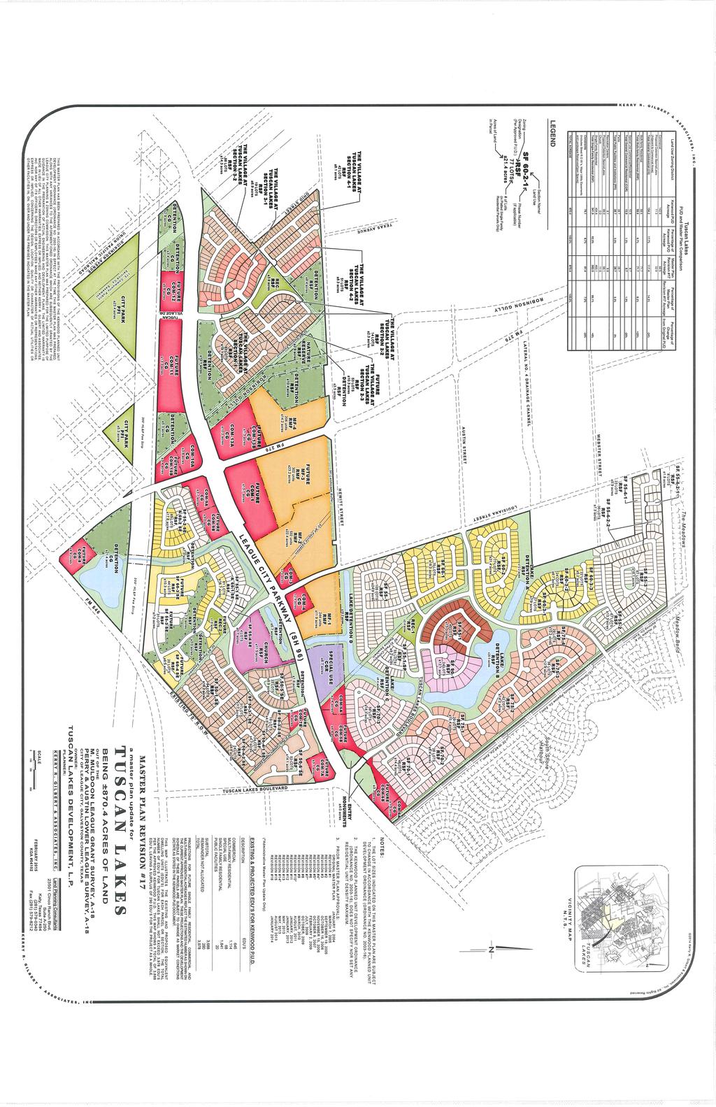
1 Planning & Zoning Commission Preliminary Plat Tuscan Lakes, SF 55-2 and 60-2 SE Planning & Development Department March 16, 2015 Request Applicant Owner Zoning Location Attachments Subdivide approximately 19.6 acres of previously unplatted property to create 65 residential lots with six reserves for landscaping, open space, amenities, and detention. Matt Stoops, BGE Kerry R. Gilbert & Associates Robert Bob Douglas, Jr., Johnson Development CG-PUD (General Commercial with a Planned Unit Development Overlay) Generally located south of League City Parkway (State Highway 96), east of Egret Bay Boulevard (FM 270). 1. Proposed Plat 2. Aerial Map 3. Photographs of the Site 4. Tuscan Lakes Master Plan #17 Site and Surrounding Area The subject site is zoned CG-PUD and is located in the Tuscan Lakes PUD. The Master Plan for Tuscan Lakes designates the site as residential single-family. The site is vacant and clear of trees; and the area is transitioning from rural to auto-suburban. Direction Surrounding Zoning Surrounding Land Use North CG-PUD Tuscan Lakes Commercial Sections 9A and 9B South OS-PUD 300-foot HL&P Fee Strip East RSF-5-PUD Tuscan Lakes SF 55-1, 60-1, and 60-3 SE West ROW and CG-PUD Egret Bay Boulevard (FM 270) and Tuscan Lakes Commercial Section 10B Access Primary access from Egret Bay Boulevard will be provided via Sarpi Drive. Secondary access will be provided from Tuscan Lakes, SF 55-1 and 60-1 SE, via Gubbio Lane. Gubbio Lane has not been completed at the time of application. Staff recommends that the final plat for this section not be considered until secondary access can be provided. Sarpi Lane and Gubbio Lane Proposed Conditions Roadway Type Local Right-of-way Width 60 feet Pavement Width 2-lane undivided, 28-foot back and Type of curb to back of curb, concrete curbed and gutter, sidewalks on developed properties Preliminary Plat Tuscan Lakes SF 55-2 and 60-2 SE (RCG) Page 1 of 2 March 16, 2015 Planning & Zoning Commission Meeting
2 Municipal Extension of Infrastructure Equivalent Dwelling Units (EDU s) are used to determine the capacity of water and waste water available to a site. With a single-family dwelling unit being equivalent to 1 EDU, the Engineering Department indicates that the water and sewer capacity are adequate to serve this development. Water service is provided by an existing 8-inch waterline that crosses Egret Bay Boulevard. The waterline would be extended into this section via Sarpi Drive. Sanitary sewer service is anticipated to be constructed south along the eastern edge of Egret Bay Boulevard. Sanitary sewer would connect to the section via a 10 foot utility easement. Staff will be requesting a condition that public infrastructure be accepted prior to consideration of the final plat. Compliance of Regulations Potential Conditions Except as noted above for the sewer infrastructure and secondary access, staff finds that the plat conforms to the subdivision regulations of Chapter 102 of the League City Code of Ordinances and Section 212 of the Texas Local Government Code. Should the preliminary plat be approved, staff recommends the following condition(s) be placed on the plat. 1. The final plat shall not be considered by the Planning and Zoning Commission until Gubbio Lane is constructed to the eastern limits of the subject plat. 2. The final plat shall not be considered by the Planning and Zoning Commission until infrastructure plans have been approved by the Engineering Department. For additional information, you may contact Ryan Granata, AICP, Planning Manager at or at ryan.granata@leaguecity.com. Preliminary Plat Tuscan Lakes SF 55-2 and 60-2 SE (RCG) Page 2 of 2 March 16, 2015 Planning & Zoning Commission Meeting
3 - Land Planning Consultants Cinco Ranch Blvd., Suite A-250 Katy, Texas Tel: SCALE: FEBRUARY 03, 2015 KGA# 04102
 HL&P Fee Strip \"OS-PUD\" UC NT KE KY H AC E P AR PE O AH KL O M A 1:3,000 Aerial Map City of League City Department of Planning & Development For Planning Purposes Only March 16, 2015")
4 Aerial Map AG LE ue C g a Le i UE TY CI way k r a ty P Tuscan Lakes SF 55-1 & 60-1 SE "RSF-5-PUD" AY ET B EGR Tuscan Lakes Commercial 9-A & 9-B "CG-PUD" e Egr t Ba yb oul Subject Property "CG-PUD" ev a rd ( 2 FM 70 ) HL&P Fee Strip "OS-PUD" UC NT KE KY H AC E P AR PE O AH KL O M A 1:3,000 Aerial Map City of League City Department of Planning & Development For Planning Purposes Only March 16, 2015
. Looking east at subject site from Egret Bay Boulevard. PHOTOGRAPH 3 Looking west at subject site from Gubbio Lane.")
5 Planning & Zoning Commission Planning & Development Department March 16, 2015 Preliminary Plat Tuscan Lakes, SF 55-2 and 60-2 SE PHOTOGRAPH 1 PHOTOGRAPH 2 Looking south/southeast at subject site from Valero (Tuscan Lakes Commercial 9-A). Looking east at subject site from Egret Bay Boulevard. PHOTOGRAPH 3 Looking west at subject site from Gubbio Lane. Preliminary Plat Tuscan Lakes, SF 55-2 and 60-2 SE March 16, Planning & Zoning Commission
6
Planning & Zoning Commission
 Planning & Zoning Commission Preliminary Plat Tuscan Lakes, SF 55-3 and 60-3 SE Planning & Development Department May 4, 2015 Request Applicant Owner Zoning Location Attachments Subdivide approximately
Planning & Zoning Commission
 Final Plat Lakes in Bay Colony, Section 7 Planning & Zoning Commission Planning & Development Department March 20, 2017 Request Applicant Owner Zoning Location Attachments Subdivide approximately 17.16
Planning & Zoning Commission
 Planning & Zoning Commission Planning & Development Department August 14, 01 Zoning Map Amendment MAP-1-0001 (Bay View Section 4) Request Rezone approximately 1.19 acres from OS (Open Space) to RSF- (Residential
Planning & Zoning Commission
 Final Plat Sedona, Section 4 Planning & Zoning Commission Planning & Development Department July 21, 2014 Request Applicant Owner Zoning Location Attachments Subdivide approximately 55.3 acres of previously
Planning & Zoning Commission
 Planning & Zoning Commission Planning & Development Department March 3, 2014 Final Plat Bay View Section 2, Phase I Request Applicant Owner Zoning Location Attachments Subdivision of approximately 12.04
Planning & Zoning Commission
 Zoning Change Z15-08 (2103 ) Planning & Zoning Commission Planning & Development Department May 18, 2015 Request Applicant /Owner Rezone approximately 2.844 acres of land from OS (Open Space) to RSF-20
Preliminary Plat - Westover Park, Section 11C
 Sectti ion 13A Wessttoverr Parrk,, Reccrreatti ion Cttrr Sectti ion 11C Sectti ion 11A Sectti ion 15 Sectti ion 16 Sectti ion 14A Sectti ion 14B Preliminary Plat - Westover Park, Section 11C Planning and
Planning. This request. incorporatedd develop the. Highway 3. similar to a. Fineas + Clover. Terri Lera of. 35 Notices. Citizen
 Zoning Change Z15-20 (Hwy 3 & Olive) Planning & Zoning Commissionn Planning & Development Department April 4, 20166 Request Rezone approximately 14.32 acres from IL (Limited Industrial) and OS (Open Space)
Planning. the propertyy. Texas Local. Government. Code. size of 2,0000 RSF-2-PUD. Road within the Wharf at a. Citizen. 0 Letter of. 1.
 Planning & Zoning Commissionn Replat Phase I of the Wharf at Clear Lake, Dock 18, Slips 1 and 2 Planning & Development Department February 15, 20166 Request Replat approximately 0.0209 acres of a previouslyy
Planning. 5,000 square , City. west of State. Avenue and. 37 Notices. Citizen. / Zoning Map 2. Aerial Map. Background. Applicant. Council.
 Zoning Change Z15-04 (Alta Vista Development) Planning & Zoning Commissionn Planning & Development Department May 4, 20155 Request Rezone approximately 8.2 acres from RSF-5 (Single-family residential with
Planning. Commons. developments. Owner. Zoning. south side of. South Shore Boulevard. 2. Aerial Map. located along. South Shoree.
 Planning & Zoning Commissionn Planning & Development Department February 16, 20144 Development Plan Hidden Lakes Commons Request Applicant Owner Zoning Location Attachments Background Site and Surrounding
Planning. Zoning Change. prepared for. Staff held an. the neighborhood at the initial meeting. of Texas Avenue. approximate. 29 Notices.
 Planning & Zoning Commissionn Zoning Change Z15-11 (Power Street and Texas Avenue) Planning & Development Department June 15, 20155 Request Rezone approximately 2.0 acres from OS (Open Space) to RSF-20
Planning & Zoning Commission
 Zoning Change 13-03 (FM 646) Planning & Zoning Commission Planning & Development Department June 3, 2013 Request Permitted Uses Rezone approximately 24.89 acres of undeveloped land from RSF-7 (Residential
Planning & Zoning Commission
 Planning & Zoning Commission Planning & Development Department March 21, 2016 Master Plan Revision Westwood Subdivision, Revision #3 Request Applicant Owner Zoning Location Attachments Background Site
Planning. Preliminary. .70 acres into. tract of land. an unplatted. Edgar Barlow. 1. Proposed 2. Aerial Map. Subdivision
 Preliminary / Final Plat Glenmont, Section Two Planning & Zoning Commissionn Planning & Development Department May 19, 20144 Request Applicant Owner Zoning Location Attachments Subdivide approximately.70
PLANNING COMMISSION REPORT REGULAR AGENDA
 PP-4-4-11 Item No. 9-1 PLANNING COMMISSION REPORT REGULAR AGENDA PC Staff Report 06/22/11 ITEM NO 9: PRELIMINARY PLAT; KASOLD WATER TOWER ADDITION; SE OF TAM O SHANTER & KASOLD DR (MKM) PP-4-4-11: Consider
WESTMINSTER PARK SUBDIVISION
 WESTMINSTER PARK SUBDIVISION Engineering Comments: FINAL PLAT COMMENTS (should be addressed prior to submitting the FINAL PLAT for review and/or signature by the City Engineer): A. Provide all of the required
DAUPHIN CREEK ESTATES SUBDIVISION
 # 12 SUB-000076-2017 DAUPHIN CREEK ESTATES SUBDIVISION Engineering Comments: FINAL PLAT COMMENTS (should be addressed prior to submitting the FINAL PLAT for review and/or signature by the City Engineer):
Planning & Zoning Commission Meeting Date: December 3, 2012
 Planning and Development Department City of League City Planning & Zoning Commission Meeting Date: December 3, 2012 Requests Rezone approximately 3.3 acres from RSF-5 (Single-family residential with a
LINCOLN COUNTY PLANNING & INSPECTIONS DEPARTMENT
 LINCOLN COUNTY PLANNING & INSPECTIONS DEPARTMENT 30 NORTH ACADEMY STREET, SUITE A, LINCOLNTON, NORTH CAROLINA 809 704-736-8440 OFFICE 704-736-8434 INSPECTION REQUEST LINE 704-73-900 FAX To: Board of Commissioners
STAFF REPORT Administrative Subdivision Hearing West 150 South Street, Parcel # , and
 Petition Number: 490-06-24 STAFF REPORT Administrative Subdivision Hearing Project Name: Project Location: Project Type: Applicant: Planning Staff: Haight Industrial Subdivision 5550 West 150 South Street,
Department of Planning & Development Services
 Department of Planning & Development Services S T A F F R E P O R T February 9, 2015 CASE NO: PROJECT: EXECUTIVE SUMMARY: ZA14-154 Plat Revision for Lots 25R-1A, 25R-1B and 25R-1C, Block 1, Woodland Heights
RESPONSIVE RESULTS-ORIENTED TRUST-BUILDERS ACCOUNTABLE
 RESPONSIVE RESULTS-ORIENTED TRUST-BUILDERS ACCOUNTABLE PZ - 0015 Staff Report City of Pearland TO: Planning and Zoning Commission FROM: Planning and Community Development MEETING: Planning & Zoning - 20
Planning. Honda) Special Use. maintenancee. service areaa. City Council Acres. Calder Road. 25 Notices. Citizen. 0 Letter of.
 Special Use. maintenancee. service areaa. City Council Acres. Calder Road. 25 Notices. Citizen. 0 Letter of.") Special Use Permit SUP14-04 (John Eagle Honda) Planning & Zoning Commissionn Planning & Development Department December 15, 20144 Request Hold a public hearing and make a recommendation to City Council
Special Use Permit SUP14-04 (John Eagle Honda) Planning & Zoning Commissionn Planning & Development Department December 15, 20144 Request Hold a public hearing and make a recommendation to City Council
COUNCIL ACTION FORM. 1. The City Council can approve the Preliminary Plat for Menards Ames Subdivision
 ITEM #: 49 DATE: 03-27-18 COUNCIL ACTION FORM SUBJECT: PRELIMINARY PLAT FOR MENARDS BACKGROUND: Menards Ames Subdivision is a proposed 41-acre development on SE 16 th Street just west of the Skunk River.
PLANNED UNIT DEVELOPMENT & SUBDIVISION STAFF REPORT Date: November 17, 2016
 PLANNED UNIT DEVELOPMENT & SUBDIVISION STAFF REPORT Date: November 17, 2016 DEVELOPMENT NAME SUBDIVISION NAME LOCATION Autonation Ford of Mobile Autonation Ford of Mobile Subdivision 901, 909, and 925
Time Extension Staff Report
 Time Extension Staff Report Subdivision Name Therrin Subdivision File Number SUB06-00020 Approval Time Extension for Lead Agency Boise City Certification Signature of Boise City Engineer Annexation Date
Wampus Mills Subdivision, Tree Removal Permit and Steep Slope Permit Approvals [#14-103]
![Wampus Mills Subdivision, Tree Removal Permit and Steep Slope Permit Approvals [#14-103]](/thumbs/95/122755150.jpg "Wampus Mills Subdivision, Tree Removal Permit and Steep Slope Permit Approvals [#14-103]") TOWN OF NORTH CASTLE WESTCHESTER COUNTY 17 Bedford Road Armonk, New York 10504-1898 PLANNING DEPARTMENT Adam R. Kaufman, AICP Director of Planning Telephone: (914) 273-3542 Fax: (914) 273-3554 www.northcastleny.com
TOWN OF NORTH CASTLE WESTCHESTER COUNTY 17 Bedford Road Armonk, New York 10504-1898 PLANNING DEPARTMENT Adam R. Kaufman, AICP Director of Planning Telephone: (914) 273-3542 Fax: (914) 273-3554 www.northcastleny.com
PENNY LAKES SUBDIVISION
 PENNY LAKES SUBDIVISION Engineering Comments: A portion of the site may be located within the J.B. Converse watershed, the primary drinking water supply for the Mobile Area Water and Sewer System. Consultation
SOS / Waiver of Subdivision Standards / John Cashin
 SOS15-00012 / Waiver of Subdivision Standards / John Cashin Summary John Cashin requests a Waiver of Subdivision Standards in the Boise Development Code that requires construction of new sidewalk for approval
EXHIBIT D. WRITTEN DESCRIPTION For. TOWNSEND VILLAGE PUD December 23, 2015 (Revised)
") I. PROJECT DESCRIPTION EXHIBIT D WRITTEN DESCRIPTION For TOWNSEND VILLAGE PUD December 23, 2015 (Revised) A. This 7.2 acre single-family residential project is located on the East side of Townsend Boulevard,
I. PROJECT DESCRIPTION EXHIBIT D WRITTEN DESCRIPTION For TOWNSEND VILLAGE PUD December 23, 2015 (Revised) A. This 7.2 acre single-family residential project is located on the East side of Townsend Boulevard,
LARAMIE COUNTY PLANNING & DEVELOPMENT DEPARTMENT
 LARAMIE COUNTY PLANNING & DEVELOPMENT DEPARTMENT Planning Building MEMORANDUM TO: FROM: Laramie County Planning Commission Brad Emmons, Planning Director DATE: March 22, 2018 TITLE: Review and recommendations
DIVISION 2 - CONSTRUCTION PLAN AND MISCELLANEOUS REQUIREMENTS
 DIVISION 2 - CONSTRUCTION PLAN AND MISCELLANEOUS REQUIREMENTS 2.1 Required Plan Sheets 2.2 Drawing Requirements 2.3 Graphic Standards 2.4 Easements 2.5 Utility Locations 2.6 Private Facility Locations
Planning. 7,000 square. 25 Notices. Citizen. / Zoning Map 2. Aerial Map. Background. - A portion. Late (DRC) for application RMF-1.
 for application RMF-1.") Zoning Change Z15-13 (Cypresss Bay Commercial) Planning & Zoning Commissionn Planning & Development Department July 6, 20155 Request Rezone approximately 2.4 acres from RSF-7 (Single-family residential
Zoning Change Z15-13 (Cypresss Bay Commercial) Planning & Zoning Commissionn Planning & Development Department July 6, 20155 Request Rezone approximately 2.4 acres from RSF-7 (Single-family residential
PLANNING COMMISSION REPORT Regular Agenda Non Public Hearing Item
 PC Staff Report 3/23/15 FDP-14-00551 Item No. 2-1 PLANNING COMMISSION REPORT Regular Agenda Non Public Hearing Item PC Staff Report 3/23/15 ITEM NO. 2: FINAL DEVELOPMENT PLAN FOR HUTTON FARMS WEST PHASE
Planning Department Oconee County, Georgia
 Planning Department Oconee County, Georgia STAFF REPORT REZONE CASE #: 6985 DATE: October 31, 2016 STAFF REPORT BY: Andrew C. Stern, Planner APPLICANT NAME: Williams & Associates, Land Planners PC PROPERTY
M E M O R A N D U M. Meeting Date: October 23, Item No. F-1. Planning and Zoning Commission. Daniel Turner, Planner I
 M E M O R A N D U M Meeting Date: October 23, 2017 Item No. F-1 To: From: Subject: Planning and Zoning Commission Daniel Turner, Planner I PUBLIC HEARING: Consider a recommendation of a of Planned Development
Planning. Special Use. to operate a. future. 1.5 acres. Avenue and. west of State. 31 Notices. Citizen. 0 Letter of. compatibility with.
 Planning & Zoning Commissionn Planning & Development Department December 21, 20155 Special Use Permit SUP15-09 (Vanderford Air) Request Hold a public hearing and make a recommendationn to City Council
CITY OF EAU CLAIRE, WISCONSIN. SPECIAL ASSESSMENT POLICY (Dated: November 8, 2016)
") CITY OF EAU CLAIRE, WISCONSIN SPECIAL ASSESSMENT POLICY (Dated: November 8, 2016) (Adopted by reference by Ordinance No. 7207 adopted November 8, 2016) PURPOSE The purpose of this Policy is to assure fair
CITY OF EAU CLAIRE, WISCONSIN SPECIAL ASSESSMENT POLICY (Dated: November 8, 2016) (Adopted by reference by Ordinance No. 7207 adopted November 8, 2016) PURPOSE The purpose of this Policy is to assure fair
PLANNED UNIT DEVELOPMENT & SUBDIVISION STAFF REPORT August 18, 2016
 PLANNED UNIT DEVELOPMENT & SUBDIVISION STAFF REPORT August 18, 2016 DEVELOPMENT NAME SUBDIVISION NAME Mullinax Ford Subdivision Mullinax Ford Subdivision LOCATION CITY COUNCIL DISTRICT District 6 Southeast
ARTICLE IV: DEVELOPMENT STANDARDS
 ARTICLE IV: DEVELOPMENT STANDARDS IV-53 409 PRIVATE STREETS A private street means any way that provides ingress to, or egress from, property by means of vehicles or other means, or that provides travel
Marion County Board of County Commissioners
 Marion County Board of County Commissioners Date: 6/28/2017 P&Z: 6/26/2017 BCC: 7/18/2017 Item Number 170701Z Type of Application Rezoning Request B-2, Community Business to R-1, Single Family Residential
City Council Agenda Item Report December 1, 2015
 City Council Agenda Item Report December 1, 2015 Contact Chance Sparks, AICP, CNUa, Director of Planning 512-312-0084 / csparks@ci.buda.tx.us SUBJECT: DELIBERATION AND POSSIBLE ACTION REGARDING APPROVAL
2 April 9, 2014 Public Hearing
 2 April 9, 2014 Public Hearing APPLICANT (Street Closure): EBENEZER BAPTIST CHURCH APPLICANT & PROPERTY OWNER (Use Permit Modification): EBENEZER BAPTIST CHURCH STAFF PLANNER: Kevin Kemp REQUESTS: A. Street
Community Development Department Council Chambers, 7:30 PM, September 7, 2017
 STAFF REPORT 2017-34P: Street Vacation Community Development Department Council Chambers, 7:30 PM, September 7, 2017 To: From: Re: Paul Luke, Chairman, Skokie Plan Commission Mike Voitik, Planning Technician
Planned Unit Development Overlay District. For. McAlister Tract PUD
 Planned Unit Development Overlay District For McAlister Tract PUD Prepared For Land Funds Two & Three, J.V. Kerry R. Gilbert & Associates, Inc. June, 2006 TABLE OF CONTENTS I. INTRODUCTION 1 II. SITE INVENTORY
TOWNSHIP OF SOLON COUNTY OF KENT, MICHIGAN. The following preamble and ordinance were offered by Member Poulsen and seconded by ORDINANCE NO.
 Final TOWNSHIP OF SOLON COUNTY OF KENT, MICHIGAN At a regular meeting of the Township Board of the Township of Solon, Kent County, Michigan, held at the Township Hall, 15185 Algoma Avenue, N.E., Cedar
FEASIBILITY REPORT FOR PROPOSED ROAD IMPROVEMENT PROJECT OF OLD VIKING BOULEVARD NOWTHEN, MINNESOTA DECEMBER 6, Prepared by:
 FEASIBILITY REPORT FOR PROPOSED ROAD IMPROVEMENT PROJECT OF OLD VIKING BOULEVARD NOWTHEN, MINNESOTA DECEMBER 6, 2018 Prepared by: 3601 THURSTON AVENUE ANOKA, MINNESOTA 55303 TELEPHONE: (763) 427-5860 I
Urban Planning and Land Use
 Urban Planning and Land Use 701 North 7 th Street, Room 423 Phone: (913) 573-5750 Kansas City, Kansas 66101 Fax: (913) 573-5796 Email: planninginfo@wycokck.org www.wycokck.org/planning To: From: City Planning
SUBJECT PARCEL(S) Property Owner(s) TMS Number Approximate Acreage Carolina Park Development, LLC
 Property Owner(s) TMS Number Approximate Acreage Carolina Park Development, LLC") Staff Report Special Planning Commission Meeting November 19, 2014 For reference, the Zoning Code and Land Development Regulations are available online. AGENDA ITEM 5c. SKETCH PLAN APPROVAL REQUEST: Request
Staff Report Special Planning Commission Meeting November 19, 2014 For reference, the Zoning Code and Land Development Regulations are available online. AGENDA ITEM 5c. SKETCH PLAN APPROVAL REQUEST: Request
PLANNED UNIT DEVELOPMENT & SUBDIVISION STAFF REPORT Date: March 15, 2007
 PLANNED UNIT DEVELOPMENT & SUBDIVISION STAFF REPORT Date: March 15, 2007 DEVELOPMENT NAME SUBDIVISION NAME LOCATION Motormax Subdivision Motormax Subdivision 2917 and 2929 Government Boulevard (South side
SECTION 7000 LAND DEVELOPMENT REQUIREMENTS
 SECTION 7000 LAND DEVELOPMENT REQUIREMENTS 7000 LAND DEVELOPMENT REQUIREMENTS... 1 7001 LEGISLATIVE AUTHORITY... 1 7001.1 LAND DEVELOPMENT... 1 7001.1.1 Title 40, Idaho Code... 1 7001.1.2 Idaho Code 40-1415
SUB ; Courthouse Manor, Preliminary Subdivision Plan
 5 Board of Supervisors Gary F. Snellings, Chairman Laura A. Sellers, Vice Chairman Meg Bohmke Jack R. Cavalier Paul V. Milde, III Cord A. Sterling Robert Bob Thomas, Jr. October 14, 2015 Anthony J. Romanello,
Estates at River's Edge - Richmond Land for Sale Acres
 Estates at Rivers Edge - Richmond Land for Sale 1836 Acres River River Trace Trace Drive Drive Quiet Brook Lane Blaisdale Road SITE ALT 1836 Acres Ideal Use: Large Lot Residential Development FEATURES
3 July 13, 2011 Public Hearing APPLICANT / PROPERTY OWNER: MARQUETTE & ASSOCIATES, L.L.C. /G.S. DEVELOPERS, L.L.C.
 3 July 13, 2011 Public Hearing APPLICANT / PROPERTY OWNER: MARQUETTE & ASSOCIATES, L.L.C. /G.S. DEVELOPERS, L.L.C. STAFF PLANNER: Faith Christie REQUEST: Conditional Change of Zoning (AG-2 Agricultural
Faribault Place 3 rd Addition Preliminary Plat, Final Plat, & PUD
 Faribault Small Town Pride Big City Opportunities! December 5, 2016 Planning Commission Public Hearing Faribault Place 3 rd Addition Preliminary Plat, Final Plat, & PUD Location Maps Faribault 2 Requests
QUARTERPATH COMMUNITY DEVELOPMENT AUTHORITY CITY OF WILLIAMSBURG, VIRGINIA SPECIAL ASSESSMENT REPORT. Prepared By: MuniCap, Inc.
 QUARTERPATH COMMUNITY DEVELOPMENT AUTHORITY CITY OF WILLIAMSBURG, VIRGINIA SPECIAL ASSESSMENT REPORT Prepared By: MuniCap, Inc. October 25, 2011 QUARTERPATH COMMUNITY DEVELOPMENT AUTHORITY CITY OF WILLIAMSBURG,
Parkland-Spanaway-Midland LUAC - Agenda
 1. 6:30 P.M. Parkland-Spanaway-Midland LUAC - Agenda Documents: 8 2 17 PSMAC Agenda.pdf 2. Parkland-Spanaway-Midland LUAC Initial Project Review Documents: Lincoln Court PP IPR PSMAC-RJ.pdf Department
Canyons South. Annexation Impact Report. September 1, 2015
 Canyons South Annexation Impact Report September 1, 2015 1 Introduction This Annexation Impact Report has been prepared to meet the statutory requirements set forth in Colorado Revised Statutes 31 12 108.5
Time Extension Staff Report
 Time Extension Staff Report Subdivision Name Lunara Subdivision File Number SUB07-00019 Approval Time Extension for Lead Agency Boise City Certification Signature of Boise City Engineer Annexation Date
Department of Planning & Development Services
 Department of Planning & Development Services S T A F F R E P O R T CASE NO: ZA15-116 November 10, 2015 PROJECT: Preliminary Plat for Kingdom Place EXECUTIVE SUMMARY: REQUEST DETAILS: DeOtte Inc. is requesting
PROJECT NH 0050(99)381 PCN 6926 YANKTON COUNTY. SD HWY 50 (4 th Street) from Broadway Ave to Archery Road in Yankton, SD
381 PCN 6926 YANKTON COUNTY. SD HWY 50 (4 th Street) from Broadway Ave to Archery Road in Yankton, SD") Public Meeting/ Open House April 4, 2013 PROJECT NH 0050(99)381 PCN 6926 YANKTON COUNTY SD HWY 50 (4 th Street) from Broadway Ave to Archery Road in Yankton, SD Grading, PCC Pavement, Asphalt Concrete
Public Meeting/ Open House April 4, 2013 PROJECT NH 0050(99)381 PCN 6926 YANKTON COUNTY SD HWY 50 (4 th Street) from Broadway Ave to Archery Road in Yankton, SD Grading, PCC Pavement, Asphalt Concrete
Towne Center Boulevard William Penn Highway. Lot 2. 1 Mile Population: 3,600 Median HH Income: $36,800
 Walmart Outparcel For Sale Huntingdon, PA Store #5470 6716 Towne Center Blvd Towne Center Boulevard William Penn Highway Lot 2 Raystown Road For more information about this site, contact: Lot 2: ±1.72
MINUTES PLANNING AND ZONING COMMISSION FEBRUARY 9, 2016 REGULAR MEETING
 MINUTES PLANNING AND ZONING COMMISSION FEBRUARY 9, 2016 REGULAR MEETING The Planning and Zoning Commission conducted its February 9, 2016, Regular Meeting in the Council Chambers of City Hall (1900 Billy
TOWN OF SIDNEY BYLAW 1390
 The contents of this Bylaw are produced and consolidated for convenience only. Every effort has been made to ensure the accuracy and completeness of the material, however, the Town cannot guarantee its
Staff Report to the North Ogden Planning Commission
 Staff Report to the North Ogden Planning Commission SYNOPSIS / APPLICATION INFORMATION Application Request: Consideration and action on an administrative application for final approval for the Legacy North
SUBDIVISION DESIGN PRINCIPLES AND STANDARDS
 SECTION 15-200 SUBDIVISION DESIGN PRINCIPLES AND STANDARDS 15-201 STREET DESIGN PRINCIPLES 15-201.01 Streets shall generally conform to the collector and major street plan adopted by the Planning Commission
Planning and Economic Development Department
 Planning and Economic Development Department SUBJECT: Consideration of a Resolution for a Single-Lot Subdivision for the Massarelli Subdivision at 801 Normandy Lane AGENDA ITEM: 9.b.ii MEETING DATE: November
BEFORE THE HEARING EXAMINER FOR THURSTON COUNTY
 COUNTY COMMISSIONERS Cathy Wolfe District One Diane Oberquell District Two Robert N. Macleod District Three HEARING EXAMINER BEFORE THE HEARING EXAMINER FOR THURSTON COUNTY In the Matter of the Application
THE CITY OF MOBILE, ALABAMA MOBILE Crry PLANNING COMMISSION
 THE CITY OF MOBILE, ALABAMA MOBILE Crry PLANNING COMMISSION LETTER OF DECISION MLK Avenue Redevelopment Corp. Attn: Michael Pierce P.O. Box 2204 Mobile, AL 36652 Re: Case #SUB2014-00040 (Subdivision) MLK
WESTMINSTER PARK PLACE SUBDIVISION
 WESTMINSTER PARK PLACE SUBDIVISION Engineering Comments: FINAL PLAT COMMENTS (should be addressed prior to submitting the FINAL PLAT for review and/or signature by the City Engineer): A. Provide all of
BOSSIER CITY PARISH METROPOLITAN PLANNING COMMISSION 620 Benton Rd. Bossier City, LA Phone: Fax: PRELIMINARY PLAT
 (OFFICE USE ONLY) Application Fee: Paid: Date: CASE # Project Information BOSSIER CITY PARISH METROPOLITAN PLANNING COMMISSION 620 Benton Rd. Bossier City, LA 71111 Phone: 318-741-8824 Fax: 318-741-8827
TULSA PARK ESTATES SUBDIVISION, RESUBDIVISION OF LOT 6
 TULSA PARK ESTATES SUBDIVISION, RESUBDIVISION OF LOT 6 Engineering Comments: FINAL PLAT COMMENTS (should be addressed prior to submitting the FINAL PLAT for review and/or signature by the City Engineer):
ZONING AMENDMENT, PLANNED UNIT DEVELOPMENT & SUBDIVISION STAFF REPORT Date: August 8, 2013
 ZONING AMENDMENT, PLANNED UNIT DEVELOPMENT & SUBDIVISION STAFF REPORT Date: August 8, 2013 NAME SUBDIVISION NAME PV-Magnolia, LLC Twelve Trees Subdivision LOCATION 2860, 2862 and 2866 Pleasant Valley Road
Marion County Board of County Commissioners
 Marion County Board of County Commissioners Date: 12/2/25 P&Z: 11/30/25 BCC: 12/16/25 Amendment No: (20)151209Z Type of Application Rezoning Request P-MH (Mobile Home Park) to B-2 (Community Business)
CITY OF SANTA ROSA COMMUNITY DEVELOPMENT DEPARTMENT STAFF REPORT FOR PLANNING COMMISSION SEPTEMBER 10, 2015 APPLICANT FILE NUMBER MJP
 ITEM NO. 9 CITY OF SANTA ROSA COMMUNITY DEVELOPMENT DEPARTMENT STAFF REPORT FOR PLANNING COMMISSION SEPTEMBER 10, 2015 PROJECT TITLE Yogurt Time Center ADDRESS/LOCATION 3093 Marlow Road ASSESSOR S PARCEL
Request Subdivision Variance to Sections 4.4 (b) & (d) of the Subdivision Regulations. Staff Planner Kevin Kemp
 & (d) of the Subdivision Regulations. Staff Planner Kevin Kemp") Applicant Property Owner Rhae Adams, Jr. Public Hearing June 8, 2016 City Council Election District Lynnhaven Agenda Item 4 Request Subdivision Variance to Sections 4.4 (b) & (d) of the Subdivision Regulations.
Applicant Property Owner Rhae Adams, Jr. Public Hearing June 8, 2016 City Council Election District Lynnhaven Agenda Item 4 Request Subdivision Variance to Sections 4.4 (b) & (d) of the Subdivision Regulations.
MCGOWIN PARK EAST OF SATCHEL PAIGE SUBDIVISION, RESUBDIVISION OF
 # 14 SUB2015-00058 MCGOWIN PARK EAST OF SATCHEL PAIGE SUBDIVISION, RESUBDIVISION OF Engineering Comments: The following comments should be addressed prior to submitting the FINAL PLAT for acceptance and
Committed to Service
 Committed to Service Paul Woods, President Rebecca W. Arnold, Vice President Sara M. Baker, Commissioner Jim D. Hansen, Commissioner Kent Goldthorpe, Commissioner August 25, 2017 Development Services TO:
Letter of Intent May 2017 (Revised November 2017)
") THE BEACH AT WOODMOOR LETTER OF INTENT MAY 2017 (REVISED NOVEMBER 2017) OWNER/APPLICANT: CONSULTANT: Lake Woodmoor Holdings LLC N.E.S. Inc. 1755 Telstar Drive, Suite 211 619 North Cascade Avenue Colorado
THE BEACH AT WOODMOOR LETTER OF INTENT MAY 2017 (REVISED NOVEMBER 2017) OWNER/APPLICANT: CONSULTANT: Lake Woodmoor Holdings LLC N.E.S. Inc. 1755 Telstar Drive, Suite 211 619 North Cascade Avenue Colorado
BOI / DRH Albertsons grocery market and fueling center & pad sites
 Paul Woods, President Rebecca W. Arnold, Vice President Sara M. Baker, Commissioner Jim D. Hansen, Commissioner Kent Goldthorpe, Commissioner March 28, 2017 To: Mark Palmer Albertsons Companies 250 E.
NORMAN, OKLAHOMA OWNER: RCB BANK APPLICATION FOR 2025 PLAN CHANGE PLANNED UNIT DEVELOPMENT PRELIMINARY PLAT. 12 December 2011 Revised 5 January 2012
 THE VILLAGE AT OAKHURST ADDITION NORMAN, OKLAHOMA OWNER: RCB BANK APPLICATION FOR 2025 PLAN CHANGE PLANNED UNIT DEVELOPMENT PRELIMINARY PLAT 12 December 2011 Revised 5 January 2012 PREPARED BY: THE RIEGER
Development Plan DP13-3 (Arlington Lofts) Planning and Zoning Meeting Date: Document Being Considered: Ordinance
 Planning and Zoning Meeting Date: Document Being Considered: Ordinance") Staff Report Development Plan DP13-3 (Arlington Lofts) Planning and Zoning Meeting Date: 6-19-13 Document Being Considered: Ordinance RECOMMENDATION Following the public hearing, consider Development Plan
Staff Report Development Plan DP13-3 (Arlington Lofts) Planning and Zoning Meeting Date: 6-19-13 Document Being Considered: Ordinance RECOMMENDATION Following the public hearing, consider Development Plan
Industrial Road Cross Dock Subdivision Minor Subdivision Preliminary Plat PLNSUB South Industrial Road Hearing date: May 9, 2013
 ADMINISTRATIVE HEARING STAFF REPORT Industrial Road Cross Dock Subdivision Minor Subdivision Preliminary Plat PLNSUB2013-00158 1900 South Industrial Road Hearing date: May 9, 2013 Applicant: Corbin Bennion
Section Preliminary Plat Checklist and Application Forms
 Section 201 - Preliminary Plat Checklist and Application Forms PRELIMINARY SUBDIVISION PLAT REVIEW PROCESS CHART PRELIMINARY SUBDIVISION PLAT APPLICATION PRELIMINARY PLAT REVIEW CHECKLIST CITY OF NAMPA
City of Colleyville Community Development Department. Subdivision Application Packet
 Community Development Department Subdivision Application Packet 1 Development Application Fees 100 Main Street Colleyville TX 76034 817.503.1050 Zoning Zoning Change $ 500 + $5 per acre Planned Unit Development
Project Description: Consider site plan approval for the construction of a new car wash in the Gateway Center subdivision.
 COMMUNITY DEVELOPMENT DEPARTMENT Planning and Zoning Division 1725 Reynolds Street, Suite 200, Brunswick, GA 31520 Phone: 912-554-7428/Fax: 1-888-252-3726 MAINLAND PLANNING COMMISSION STAFF REPORT August
PLANNING COMMISSION STAFF REPORT SURROUNDING LAND USES. Light Industrial, Office, UDOT Right of Way (Interstate- 15)
") PLANNING COMMISSION STAFF REPORT MEETING DATE: March 21, 2019 PROJECT NUMBER: S-18-014 REQUEST: Final Plat approval for a single lot subdivision ADDRESS: 3535 South 500 West 7 Parcels: 15-36-127-021-0000,
PLANNING COMMISSION STAFF REPORT MEETING DATE: March 21, 2019 PROJECT NUMBER: S-18-014 REQUEST: Final Plat approval for a single lot subdivision ADDRESS: 3535 South 500 West 7 Parcels: 15-36-127-021-0000,
Proposed Amendments Knoxville-Knox County Minimum Subdivision Regulations. Public Workshops
 Proposed Amendments Knoxville-Knox County Minimum Subdivision Regulations Public Workshops Restructuring EXISTING TABLE OF CONTENTS SECTION 1 PURPOSE, TITLE, AUTHORITY SECTION 2 DEFINITIONS SECTION 3 ADMINISTRATION
FUTURE LAND USE MAP AMENDMENT AND ZONE CHANGE STAFF REPORT
 2017-14-LUM & 2017-79-Z-CO / WB Page 1 of 12 UTURE LAND USE MAP AMENDMENT AND ZONE CHANGE STA REPORT Docket Numbers: 2017-14-LUM and 2017-79-Z-CO/WB Public Hearing Date: November 16, 2017 Pre-Application
Project Narrative Cherry Street Industrial Park Expansion - Subdivision and Street Extension
 Project Narrative Cherry Street Industrial Park Expansion - Subdivision and Street Extension The Ithaca Urban Renewal Agency (IURA) proposes to develop a 6.0 acre vacant parcel located at the southerly
SUBDIVISION APPLICATION
 SUBDIVISION APPLICATION Preliminary Plat Minor Plat Final Plat Amended Plat Applicant Name: Owner (if different from applicant) Name: Company: Company: Address: Address: City, State, Zip City, State, Zip
Subdivision of existing two lots into three lots.
 PP-15-00189 Item No. 4-1 PC Staff Report 06/22/2015 PLANNING COMMISSION REPORT NON PUBLIC HEARING ITEM PUBLIC HEARING ON THE VARIANCE ONLY ITEM NO 4: PRELIMINARY PLAT FOR DEERFIELD WOODS SUBDIVISION NO.
Administrative Action
 Administrative Action Preliminary Subdivision City of Raleigh Development Plans Review Center One Exchange Plaza Raleigh, NC 27602 (919) 516-2626 www.raleighnc.gov Case File / Name: General Location: CAC:
PUD 42 - Warner Ranch PUD - Amend. 2 Item No. 4B ZONING ZON
 PUD 42 - Warner Ranch PUD - Amend. 2 Item No. 4B ZONING ZON1210-001 CASE PLANNER: Steve Hopkins REQUEST: Approval of PUD 42 - Warner Ranch PUD - Amend. 2 ZONING AT TIME OF APPLICATION: PUD 42 CURRENT USE
CITY COUNCIL STUDY SESSION MEMORANDUM
 City and County of Broomfield, Colorado To: From: Prepared by: Owner Applicant Property Size Property Location: CITY COUNCIL STUDY SESSION MEMORANDUM Mayor and City Council Charles Ozaki, City and County
Re: Case # ZP Preplanning Application for 8 townhomes at 1526 Ingalls Street in Lakewood, CO.
 Planning Department Civic Center North 480 South Allison Parkway Lakewood, Colorado 80226-3127 303.987.7505 303.987.7057 TTY/TDD Lakewood.org/Planning February 27, 2017 Nathan Taylor 601 S Jason Street
Subdivision Staff Report
 Subdivision Staff Report Subdivision Name Madera Creek File Number SUB06-00068 Subdivision Approval Final Plat Lead Agency Boise City Annexation Date December 9, 1974 Comp. Plan Complies Public Hearing
EDGEWATER PLANNING AND ZONING COMMISSION RESOLUTION NO. PC
 EDGEWATER PLANNING AND ZONING COMMISSION RESOLUTION NO. PC 2019-02 A RESOLUTION CONDITIONALLY APPROVING A PRELIMINARY PLAT OF PARCELS A, B, C, D, E AND F, IN THE SOUTHEAST ¼ OF THE SOUTHWEST ¼ OF SECTION
PLANNING COMMISSION REPORT Regular Agenda Non-Public Hearing Item PRELIMINARY PLAT FOR JOHNSTON ADDITION; 706 E 23 RD ST (MKM)
") PP-16-00261 Item No. 2A- 1 PC Staff Report PP-16-00261 ITEM NO. 2A: PLANNING COMMISSION REPORT Regular Agenda Non-Public Hearing Item PRELIMINARY PLAT FOR JOHNSTON ADDITION; 706 E 23 RD ST (MKM) PP-16-00261:
PP-16-00261 Item No. 2A- 1 PC Staff Report PP-16-00261 ITEM NO. 2A: PLANNING COMMISSION REPORT Regular Agenda Non-Public Hearing Item PRELIMINARY PLAT FOR JOHNSTON ADDITION; 706 E 23 RD ST (MKM) PP-16-00261: