Project Narrative Cherry Street Industrial Park Expansion - Subdivision and Street Extension
|
|
|
- Clementine Nash
- 5 years ago
- Views:
Transcription
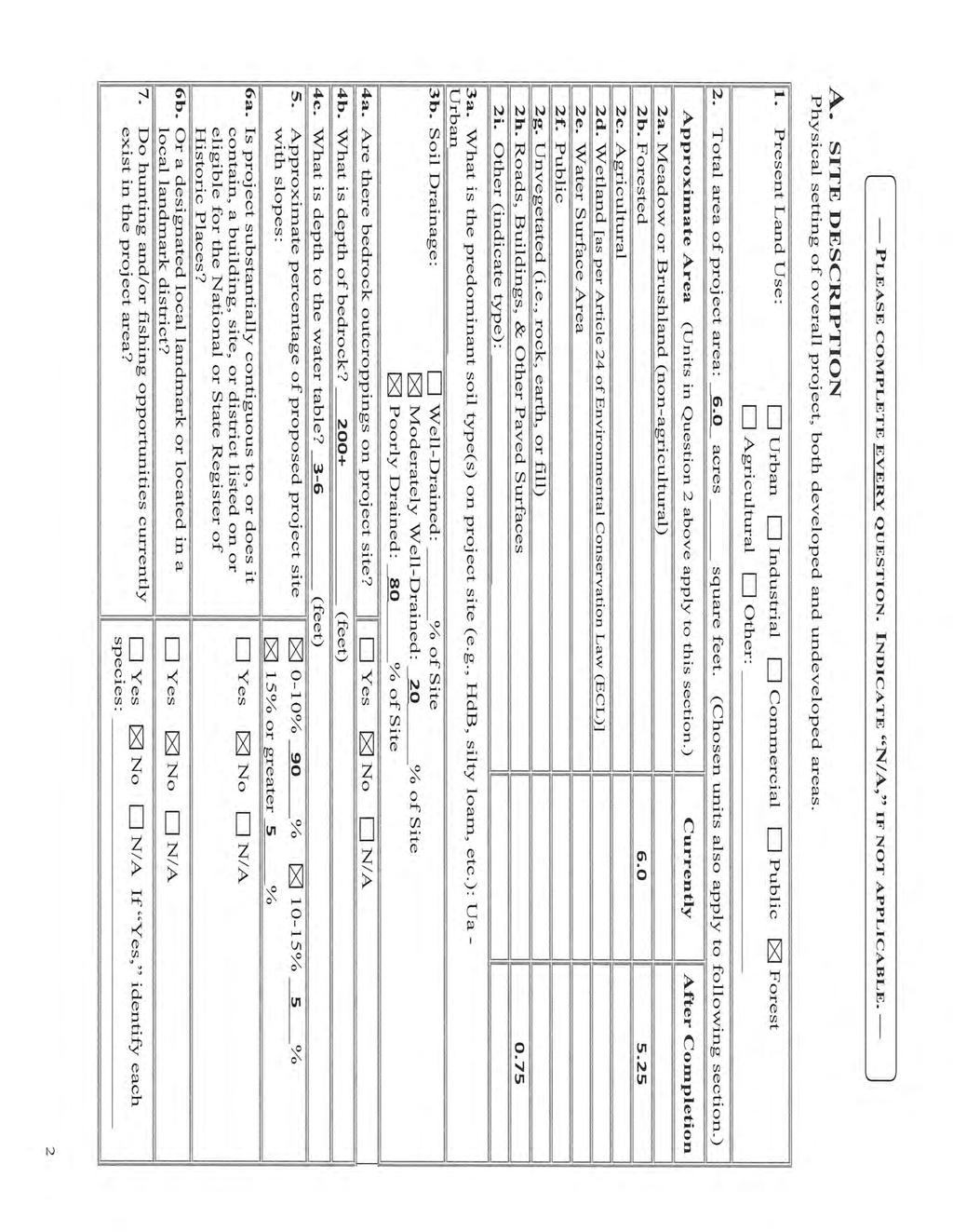
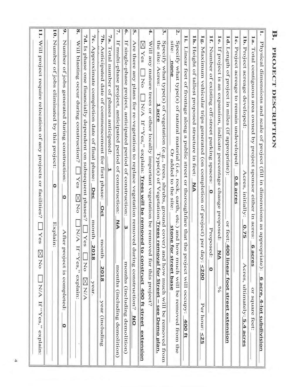
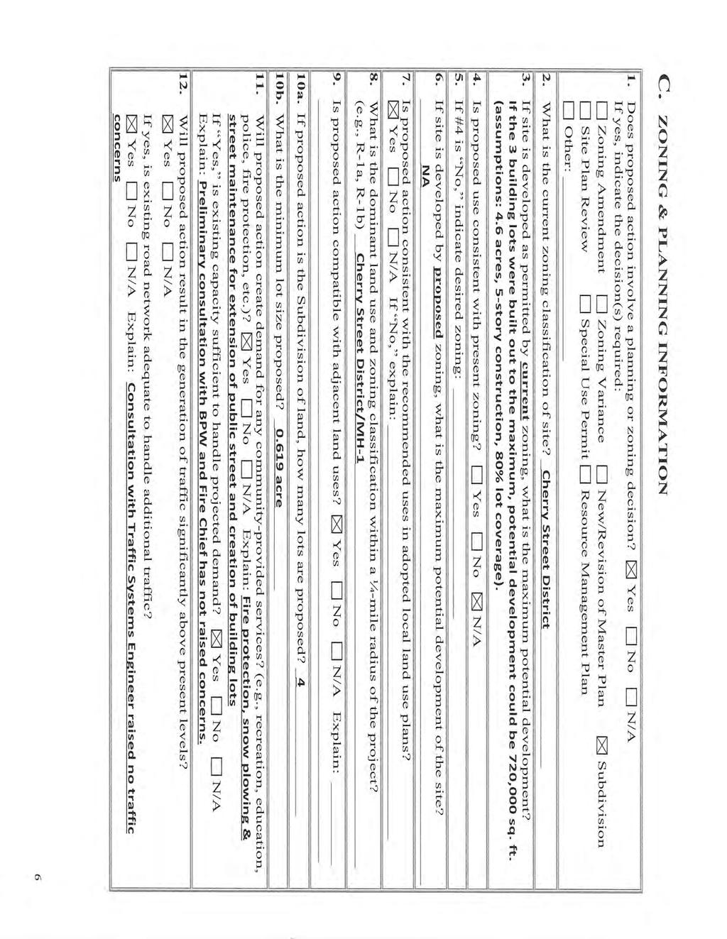
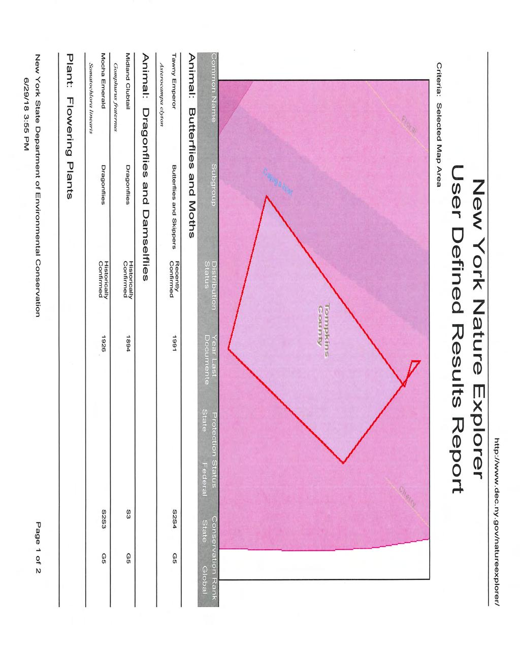
1 Project Narrative Cherry Street Industrial Park Expansion - Subdivision and Street Extension The Ithaca Urban Renewal Agency (IURA) proposes to develop a 6.0 acre vacant parcel located at the southerly end of Cherry Street to expand the Cherry Street Industrial Park. To create three building lots requires an approximate 400 linear foot extension of the public street and a subdivision of the parcel. Enclosed are applications for a four-lot subdivision and a site plan for construction of the street. The street extension is intended to be conveyed to the City upon completion. In 2012, the City of Ithaca subdivided an 8.5 acre parcel at the southerly end of Cherry Street into two parcels. The City retained a 2.5 acre parcel containing wetland habitat as open space and transferred the remaining 6.0 acre parcel to the IURA for economic development purposes. The proposed subdivision will create four (4) lots that comply with Cherry District zoning requirements and an extension of the pubic street. The IURA intends to convey the 2.6 acre Lot 3 to Emmy s Organics, Inc. for construction of a food manufacturing facility. Two 1.0 acre parcels (Lots 1 and 2) will be marketed for sale to small businesses that create jobs for low- and moderate-income persons. Lot 4 will be retained to support the future Black Diamond Trail as a vegetated buffer and possible trailhead access point. Lot 4 is the only parcel in the subdivision with land located within the 100-year flood hazard area (elevation ). The IURA seeks to convey this parcel to the City of Ithaca. The IURA will construct an extension of Cherry Street to city standards for conveyance to the City upon completion and Board of Public Works acceptance. A turnaround will be constructed at the end of the street that can accommodate fire department apparatus. The road extension will include underground water, sanitary, gas and storm water utilities and above ground electric. The street will include curbs and provide a 31-foot paved width to match the existing portion of Cherry Street. A sidewalk along the eastern side of the road will also be installed. Street trees will be provided in consultation with the City Forester. The site was extensively disturbed during construction of the Flood Control Channel in 1967 when dredge spoils were placed on a majority of the site. Since then, this site has reforested primarily with poplar, locust and cottonwood trees. Tree removal to construct the street is limited to trees in the ROW and the grading line for the street. Trees on Lots 1 and 2 will be retained for now and be subject to review when future projects seek site plan approval. Please note that the demolition sheet shows trees to be removed and trees to be retained within approximately 25 feet of areas to be disturbed. Many more trees exist on this forested property that are not mapped as they are not located near areas of disturbance. The 6.0 acre parcel includes several easements. A utility easement for extension of the city waterline extends along the western and southern boundary of the 6.0 acre parcel so in the future the waterline can cross the railroad tracks and connect to the water supply system serving the southwest area. As a waterline will be included in the street extension, the IURA seeks to relocate the utility easement to follow the street then extend west along the common lot line between lots 1 and 2 (see plat). Preliminary discussion on the conceptual street plan at the 7/17/18 Board of Public Works meeting suggests support for relocating this utility easement. Please contact me at NBohn@cityofithaca.org with any questions.
2

3
4
5
6
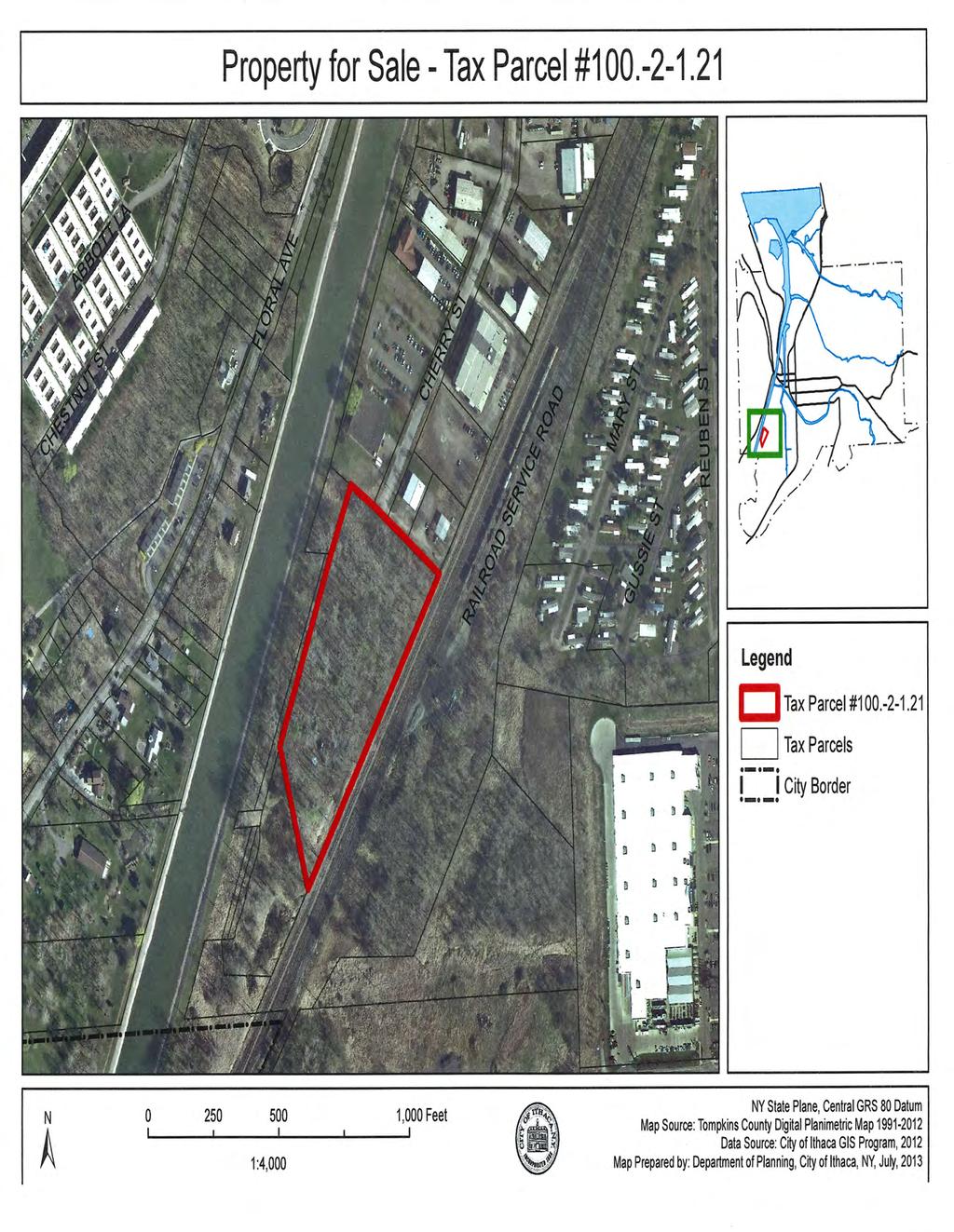
7 Property for Sale - Tax Parcel # ABBOTT LA CHESTNUT ST FLORAL AVE CHERRY ST RAILROAD SERVICE ROAD MARY ST GUSSIE ST REUBEN ST Legend Tax Parcel # Tax Parcels City Border ± ,000 Feet 1:4,000 NY State Plane, Central GRS 80 Datum Map Source: Tompkins County Digital Planimetric Map Data Source: City of Ithaca GIS Program, 2012 Map Prepared by: Department of Planning, City of Ithaca, NY, July, 2013
8
9
10
11
12
13
14
15
16

17
18
19
20
21
22
23
24
25
26
27
28
29
30
31
32
33
34 0.0000
Residential Minor Subdivision Review Checklist
 Residential Minor Subdivision Review Checklist Plan Submittal Requirements: 2 full sets of stamped plans Electric submittal - all plans contained in a single PDF 3 full sets if commercial kitchen or dining
WESTMINSTER PARK SUBDIVISION
 WESTMINSTER PARK SUBDIVISION Engineering Comments: FINAL PLAT COMMENTS (should be addressed prior to submitting the FINAL PLAT for review and/or signature by the City Engineer): A. Provide all of the required
MTC ALABAMA SUBDIVISION
 # 2 SUB-000370-2017 MTC ALABAMA SUBDIVISION Engineering Comments: FINAL PLAT COMMENTS (should be addressed prior to submitting the FINAL PLAT for review and/or signature by the City Engineer): A. Provide
Residential Major Subdivision Review Checklist
 Residential Major Subdivision Review Checklist Plan Submittal Requirements: 2 full sets of stamped plans Electric submittal - all plans contained in a single PDF 3 full sets if commercial kitchen or dining
PARK PLACE SUBDIVISION
 PARK PLACE SUBDIVISION Engineering Comments: Must comply with the Mobile County Flood Damage Prevention Ordinance. The plat illustrates the proposed 53 lot, 12.6 + acres subdivision which is located on
KRONER S MOBILE WEST COMMERCIAL BUSINESS PARK SUBDIVISION
 KRONER S MOBILE WEST COMMERCIAL BUSINESS PARK SUBDIVISION Engineering Comments: Must comply with the Mobile County Flood Damage Prevention Ordinance. Development shall be designed to comply with the storm
NOT TO BE SUBMITTED WITH SKETCH DESIGN APPROVAL Subdivision Checklist: Major Subdivision Final Plat
 Must be received with review fee (equal to $200.00, plus $25.00 per lot) no later than 15 days prior to Planning Board meeting, which is normally the first Monday of the month (certain holidays may modify
City of Grande Prairie Development Services Department
 City of Grande Prairie Development Services Department COUNTRYSIDE SOUTH OUTLINE PLAN Prepared by: GPEC Consulting Ltd. #202, 10712-100th Street Grande Prairie, AB Council Resolution of August 20, 2001
BROADWAY THREE NOTCH ROAD SUBDIVISION
 # 3 SUB-000803-2018 BROADWAY THREE NOTCH ROAD SUBDIVISION Engineering Comments: FINAL PLAT COMMENTS (should be addressed prior to submitting the FINAL PLAT for review and/or signature by the City Engineer):
ZONING AMENDMENT & SUBDIVISION STAFF REPORT Date: November 3, 2016
 ZONING AMENDMENT & SUBDIVISION STAFF REPORT Date: November 3, 2016 APPLICANT NAME SUBDIVISION NAME David Shumer 5955 Airport Subdivision CITY COUNCIL DISTRICT District 6 5955 Airport Boulevard, 754 Linlen
ALBA BEACH SUBDIVISION, RESUBDIVISION OF LOT 17
 ALBA BEACH SUBDIVISION, RESUBDIVISION OF LOT 17 Engineering Comments: FINAL PLAT COMMENTS (should be addressed prior to submitting the FINAL PLAT for acceptance and signature by the City Engineer): A.
GWINNETT COUNTY CSO CONSERVATION SUBDIVISION OVERLAY DISTRICT REQUIREMENTS
 GWINNETT COUNTY CSO CONSERVATION SUBDIVISION OVERLAY DISTRICT REQUIREMENTS Section 1316. CSO Conservation Subdivision Overlay District. 1. Purposes. The purposes of this overlay district are as follows:
PLANNED UNIT DEVELOPMENT & SUBDIVISION STAFF REPORT Date: July 20, 2017
 PLANNED UNIT DEVELOPMENT & SUBDIVISION STAFF REPORT Date: July 20, 2017 DEVELOPMENT NAME SUBDIVISION NAME LOCATION Rangeline Crossing III Subdivision Rangeline Crossing III Subdivision 5289 Halls Mill
APPLICATION for MINOR SUBDIVISION REVIEW for CONCEPT and FINAL PLAT within COALVILLE CITY. Project Name: Project Address or Area: Name of Owner:
 APPLICATION for MINOR SUBDIVISION REVIEW for CONCEPT and FINAL PLAT within COALVILLE CITY For Office Use Only: Application #: Application Date: PC Approval Date: CC Approval Date: Community Development
City of Prior Lake APPLICATION FOR PRELIMINARY PLAT
 City of Prior Lake APPLICATION FOR PRELIMINARY PLAT Requested Action Brief description of proposed project (Please describe the proposed amendment, project, or variance request. Attach additional sheets
ARTICLE FIVE FINAL DRAFT
 ARTICLE FIVE 021218 FINAL DRAFT Sec. 503.6 Open Space Preservation Option Open Space Preservation Option Open Space Preservation developments may be approved in the AR, R-1, R-2 and R-3 zoning districts,
PORT CITY COMMERCE PARK SUBDIVISION
 # 4 SUB2015-00019 PORT CITY COMMERCE PARK SUBDIVISION Engineering Comments: Must comply with the Mobile County Flood Damage Prevention Ordinance. Development shall be designed to comply with the storm
PRELIMINARY PLAT CHECK LIST
 PRELIMINARY PLAT CHECK LIST Name of Proposed Subdivision: The following items must be included with the initial submittal of a Preliminary Plat: Application, filled out completely Project Narrative Pre-application
Wampus Mills Subdivision, Tree Removal Permit and Steep Slope Permit Approvals [#14-103]
![Wampus Mills Subdivision, Tree Removal Permit and Steep Slope Permit Approvals [#14-103]](/thumbs/95/122755150.jpg "Wampus Mills Subdivision, Tree Removal Permit and Steep Slope Permit Approvals [#14-103]") TOWN OF NORTH CASTLE WESTCHESTER COUNTY 17 Bedford Road Armonk, New York 10504-1898 PLANNING DEPARTMENT Adam R. Kaufman, AICP Director of Planning Telephone: (914) 273-3542 Fax: (914) 273-3554 www.northcastleny.com
TOWN OF NORTH CASTLE WESTCHESTER COUNTY 17 Bedford Road Armonk, New York 10504-1898 PLANNING DEPARTMENT Adam R. Kaufman, AICP Director of Planning Telephone: (914) 273-3542 Fax: (914) 273-3554 www.northcastleny.com
PRELMINARY PLAT CHECKLIST
 PRELMINARY PLAT CHECKLIST A. All preliminary plat submitted for approval shall be prepared by a Registered Professional Land Surveyor. B. Preliminary plats must be drawn to a scale of XXX with such accuracy
WESTMINSTER PARK PLACE SUBDIVISION
 WESTMINSTER PARK PLACE SUBDIVISION Engineering Comments: FINAL PLAT COMMENTS (should be addressed prior to submitting the FINAL PLAT for review and/or signature by the City Engineer): A. Provide all of
SUBMITTAL REQUIREMENTS: The number indicates the number of copies for submittal (if applicable).
.") Office Use Only Preliminary Long Plat Long Subdivision Applicant Checklist PLANNING, COMMUNITY, & ECONOMIC DEVELOPMENT DEPARTMENT PRELIMINARY LONG PLAT LONG SUBDIVISION CHECKLIST Mailing Address: P.O.
Office Use Only Preliminary Long Plat Long Subdivision Applicant Checklist PLANNING, COMMUNITY, & ECONOMIC DEVELOPMENT DEPARTMENT PRELIMINARY LONG PLAT LONG SUBDIVISION CHECKLIST Mailing Address: P.O.
PLANNED UNIT DEVELOPMENT & SUBDIVISION STAFF REPORT Date: September 15, 2016
 # 10 SUB2016-00089 PLANNED UNIT DEVELOPMENT & SUBDIVISION STAFF REPORT Date: September 15, 2016 NAME SUBDIVISION NAME LOCATION Lot 12 Laughlin Industrial Park Subdivision Lot 12 Laughlin Industrial Park
Heber City Planning Commission Application
 Project Information Heber City Planning Commission Application 75 North Main Street, Heber City, UT 84032 (435) 657-7898 or (435) 654-4830 Fax (435) 657-2543 www.ci.heber.ut.us Date submitted: Zone: Number
Administrative Plat Application Form
 1 Administrative Plat Application Form This form shall be submitted with each application for an administrative plat. CONTACT INFORMATION Applicant Architect (if different) Property Owner (if different)
GeoPoint 213 Hobbs Street Tampa, Florida
 AIRPORT ROAD PINELAND P.R.D. SUBDIVISION - PHASES 2 & 3 DESCRIPTION: A parcel of land lying in Sections 13 and 24, Township 14 South, Range 31 East, Volusia County, Florida, and being more particularly
Preliminary Subdivision Application (Minor) (Three (3) lots or less)
 (Three (3) lots or less)") Gunnison City Offices www.gunnisoncity.org 38 West Center Gunnison, Utah 84634 (435) 528 7969 Date of Application: Preliminary Subdivision Application (Minor) (Three (3) lots or less) APPLICANT INFORMATION
Gunnison City Offices www.gunnisoncity.org 38 West Center Gunnison, Utah 84634 (435) 528 7969 Date of Application: Preliminary Subdivision Application (Minor) (Three (3) lots or less) APPLICANT INFORMATION
City of Prior Lake APPLICATION FOR REGISTERED LAND SURVEY
 Case File No. Property Identification No. City of Prior Lake APPLICATION FOR REGISTERED LAND SURVEY Requested Action Brief description of proposed project (Please describe the proposed amendment, project,
ARTICLE VI. SUBDIVISION STANDARDS, PUBLIC
 ARTICLE VI. SUBDIVISION STANDARDS, PUBLIC IMPROVEMENTS, AND DESIGN REQUIREMENTS ARTICLE VI. SUBDIVISION STANDARDS, PUBLIC IMPROVEMENTS, AND DESIGN REQUIREMENTS DIVISION 1. GENERAL PROVISIONS Sec. 21-6100.
MAJOR SUBDIVISION PRELIMINARY PLAT CHECKLIST
 TOWNSHIP OF EGG HARBOR PLANNING BOARD/ZONING BOARD OF ADJUSTMENT 3515 BARGAINTOWN ROAD EGG HARBOR TOWNSHIP, NJ 08234 MAJOR SUBDIVISION PRELIMINARY PLAT CHECKLIST The following checklist is designed to
PLANNED UNIT DEVELOPMENT, SIDEWALK WAIVER, & SUBDIVISION STAFF REPORT Date: November 6, 2008
 PLANNED UNIT DEVELOPMENT, SIDEWALK WAIVER, & SUBDIVISION STAFF REPORT Date: November 6, 2008 DEVELOPMENT NAME SUBDIVISION NAME LOCATION Frascati Shops, Inc. Frascati Subdivision 1120 Paper Mill Road CITY
Preliminary Subdivision Application (Major) (Four (4) lots or more)
 (Four (4) lots or more)") Gunnison City Offices www.gunnisoncity.org 38 West Center Gunnison, Utah 84634 (435) 528 7969 Date of Application: Preliminary Subdivision Application (Major) (Four (4) lots or more) APPLICANT INFORMATION
Gunnison City Offices www.gunnisoncity.org 38 West Center Gunnison, Utah 84634 (435) 528 7969 Date of Application: Preliminary Subdivision Application (Major) (Four (4) lots or more) APPLICANT INFORMATION
LAND USE APPLICATION
 LAND USE APPLICATION File Name: File No(s).: Receipt No.: Receipt Date: Received By: Amount.: $ Instructions for Applicants Please read and follow all instructions on your application carefully. If you
DAWES SWITCHING STATION SUBDIVISION
 DAWES SWITCHING STATION SUBDIVISION Engineering Comments: Must comply with the Mobile County Flood Damage Prevention Ordinance. Development shall be designed to comply with the storm water detention and
APPLICATION PROCEDURE
 ANTRIM PLANNING BOARD P. O. Box 517 Antrim, New Hampshire 03440 Phone: 603-588-6785 FAX: 603-588-2969 APPLICATION FORM AND CHECKLIST FOR MINOR OR MAJOR SITE PLAN REVIEW File Date Received By APPLICATION
McGowin Park, LLC. B-3, Community Business District
 # 10, 11, 12 SUB2014-00024 ZON2014-00500 ZON2014-00501 SUBDIVISION, PLANNED UNIT DEVELOPMENT (East), PLANNED UNIT DEVELOPMENT (West) STAFF REPORT Date: April 3, 2014 DEVELOPMENT NAME LOCATION McGowin Park,
CONCEPTUAL MASTER PLAN CHECKLIST Major Land Development Project
 CONCEPTUAL MASTER PLAN CHECKLIST Major Land Development Project To initiate the application, the applicant shall submit to the Administrative Officer: 1. The application review fee, as established by the
AMELIA LAKE SUBDIVISON, PHASES 1-2
 # 1 HOLDOVER Revised SUB2014-00089 AMELIA LAKE SUBDIVISON, PHASES 1-2 Engineering Comments: Must comply with the Mobile County Flood Damage Prevention Ordinance. Development shall be designed to comply
SUBDIVISION, PLANNED UNIT DEVELOPMENT, & REZONING STAFF REPORT Date: September 17, 2015
 SUBDIVISION, PLANNED UNIT DEVELOPMENT, & REZONING STAFF REPORT Date: September 17, 2015 APPLICANT NAME SUBDIVISION NAME DEVELOPMENT NAME LOCATION Daniel Clark Mack Manufacturing Subdivision, Resubdivision
Administrative Action
 Administrative Action Preliminary Subdivision City of Raleigh Development Plans Review Center One Exchange Plaza Raleigh, NC 27602 (919) 516-2626 www.raleighnc.gov Case File / Name: General Location: CAC:
FINAL PLAT APPLICATION
 FINAL PLAT APPLICATION (Page 1 of 3) LEGAL OWNER(s): NAME: STREET ADDRESS OWNER(s): CITY, STATE, ZIP CODE: PHONE NUMBER: BILLING ADDRESS: NAME OF ENGINEER/SURVEYOR: Engineer/Surveyor Address, Phone: PROPERTY
SUBDIVISION, PLANNED UNIT DEVELOPMENT, ZONING AMENDMENT, & SIDEWALK WAIVER STAFF REPORT Date: July 19, 2018
 SUBDIVISION, PLANNED UNIT DEVELOPMENT, ZONING AMENDMENT, & SIDEWALK WAIVER STAFF REPORT Date: July 19, 2018 NAME SUBDIVISION NAME LOCATION West Mobile Properties, LLC U.S. Machine Subdivision 556, 566,
ZONING AMENDMENT & SUBDIVISION STAFF REPORT Date: July 3, 2014
 ZONING AMENDMENT & SUBDIVISION STAFF REPORT Date: July 3, 2014 APPLICANT NAME SUBDIVISION NAME LOCATION Georgia Crown Distributing Subdivision Georgia Crown Distributing Subdivision Southwest corner of
DEVELOPMENT PLAN REVIEW CHECKLIST. To initiate the application, the applicant shall submit to the Administrative Officer:
 DEVELOPMENT PLAN REVIEW CHECKLIST To initiate the application, the applicant shall submit to the Administrative Officer: 1. Sixteen (16) copies of the Project Review Application Form, printed double-sided;
City of Prior Lake APPLICATION FOR COMBINED PRELIMINARY AND FINAL PLAT
 Case File No. Property Identification No. City of Prior Lake APPLICATION FOR COMBINED PRELIMINARY AND FINAL PLAT Requested Action Brief description of proposed project (Please describe the proposed amendment,
WRITTEN DECISION OF THE HAYDEN CITY COUNCIL REGARDING MAPLE GROVE PRELIMINARY SUBDIVISION APPLICATION (SUB-0013) HAYDEN SIGNATURE, LLC
 HAYDEN SIGNATURE, LLC") WRITTEN DECISION OF THE HAYDEN CITY COUNCIL REGARDING MAPLE GROVE PRELIMINARY SUBDIVISION APPLICATION (SUB-0013) HAYDEN SIGNATURE, LLC Application of Hayden Signature, LLC, an Idaho limited liability company,
WRITTEN DECISION OF THE HAYDEN CITY COUNCIL REGARDING MAPLE GROVE PRELIMINARY SUBDIVISION APPLICATION (SUB-0013) HAYDEN SIGNATURE, LLC Application of Hayden Signature, LLC, an Idaho limited liability company,
LAND DEVELOPMENT CHECKLIST GREEN TREE BOROUGH Green Tree Planning Commission 10 West Manilla Avenue Pittsburgh, PA
 TO BE COMPLETED BY BOROUGH: LAND DEVELOPMENT CHECKLIST GREEN TREE BOROUGH Green Tree Planning Commission 10 West Manilla Avenue Pittsburgh, PA 15220 412-921-1110 SP - - DATE STAMP RECEIVED NOTE TO ALL
MOBILE TOWERS SUBDIVISION
 # 3 SUB2014-00100 MOBILE TOWERS SUBDIVISION Engineering Comments: The following comments should be addressed prior to submitting the FINAL PLAT for acceptance and signature by the City Engineer: 1) Provide
Planning Department st Avenue East Kalispell, MT Phone: (406) Fax: (406)
 Fax: (406)") Planning Department 201 1 st Avenue East Kalispell, MT 59901 Phone: (406) 758-7940 Fax: (406) 758-7739 www.kalispell.com/planning April 1, 2015 Doug Russell, City Manager City of Kalispell 201 1 st Ave
Planning Department 201 1 st Avenue East Kalispell, MT 59901 Phone: (406) 758-7940 Fax: (406) 758-7739 www.kalispell.com/planning April 1, 2015 Doug Russell, City Manager City of Kalispell 201 1 st Ave
SUBMITTAL REQUIREMENTS: The number indicates the number of copies for submittal (if applicable).
.") Office Use Only Preliminary Long Plat Long Subdivision Applicant Checklist PLANNING, COMMUNITY, & ECONOMIC DEVELOPMENT DEPARTMENT FINAL LONG PLAT LONG SUBDIVISION CHECKLIST Mailing Address: P.O. Box 547,
Office Use Only Preliminary Long Plat Long Subdivision Applicant Checklist PLANNING, COMMUNITY, & ECONOMIC DEVELOPMENT DEPARTMENT FINAL LONG PLAT LONG SUBDIVISION CHECKLIST Mailing Address: P.O. Box 547,
Public Notice U.S. ARMY CORPS OF ENGINEERS, GALVESTON DISTRICT AND TEXAS COMMISSION ON ENVIRONMENTAL QUALITY
 Public Notice U.S. Army Corps Permit Application No: SWG-2016-00384 Of Engineers Date Issued: 27 December 2018 Galveston District Comments Due: 29 January 2019 U.S. ARMY CORPS OF ENGINEERS, GALVESTON DISTRICT
CITY OF OAK HARBOR Development Services Department
 CITY OF OAK HARBOR Development Services Department Shortt Subdiiviisiions Shorrtt Pllatt Reviiew Prrocess IIII What is a Short Plat, and when is it necessary? A short plat is a map that represents a short
SECTION 4: PRELIMINARY PLAT
 SECTION 4: PRELIMINARY PLAT After the completion of the sketch plan process, if submitted, the owner or developer shall file with the City an application for preliminary plat. The preliminary plat stage
LABEL PLEASE NOTE: ALL APPLICATIONS AND SITE PLANS MUST BE COMPLETED IN BLACK OR BLUE INK ONLY Intake by:
 STAFF USE ONLY Thurston County Resource Stewardship 2000 Lakeridge Dr. S.W. Olympia, WA 98502 (360)786-5490 / (360)754-2939 (Fax) TDD Line (360) 754-2933 Email: permit@co.thurston.wa.us Supplemental Application
PRELIMINARY PLAN CHECKLIST Major Land Development Projects. To initiate the application, the applicant shall submit to the Administrative Officer:
 PRELIMINARY PLAN CHECKLIST Major Land Development Projects To initiate the application, the applicant shall submit to the Administrative Officer: 1. The application review fee, as established by the South
SUBCHAPTER 02C - SECONDARY ROADS SECTION SECTION SECONDARY ROADS
 SUBCHAPTER 02C - SECONDARY ROADS SECTION SECTION.0100 - SECONDARY ROADS Note: The Department of Transportation publishes a volume entitled "Minimum Design and Construction Criteria for Subdivision Streets"
Application For Development Review (Subdivisions and Site Plan Review)
") Application For Development Review (Subdivisions and Site Plan Review) Thank you for your interest in Pickens County, South Carolina. This packet includes the necessary documents for review of subdivision
Application For Development Review (Subdivisions and Site Plan Review) Thank you for your interest in Pickens County, South Carolina. This packet includes the necessary documents for review of subdivision
SECTION SITE SURVEYS
 PART 1 - GENERAL 1.1 DESCRIPTION SECTION 02 21 00 SPEC WRITER NOTES: 1. Use this section only for NCA projects. 2. Delete between //---// if not applicable to project. Also delete any other item or paragraph
ZONING AMENDMENT & SUBDIVISION STAFF REPORT Date: June 18, 2015
 ZONING AMENDMENT & SUBDIVISION STAFF REPORT Date: June 18, 2015 APPLICANT NAME SUBDIVISION NAME EAA LLC / Eryka Rogers Aaiden Place Subdivision LOCATION 2480 Government Boulevard (North side of Government
APPLICATION FOR PRELIMINARY PLAT CERRO GORDO COUNTY, IOWA
 APPLICATION FOR PRELIMINARY PLAT CERRO GORDO COUNTY, IOWA Before subdividing any tract of land and previous to the filing of an Application for conditional approval of the Preliminary Plat, the subdivider
Use permitted by: Right Special Exemption
 CENTER TOWNSHIP 150 Henricks Road Butler, PA 16001-8472 Phone (724) 282-7805 Fax (724) 282-6550 Application Number: FEE COLLECTED: Application for: Preliminary Final Land Development Location: Map and
TOWN OF MANCHESTER PLANNING AND ZONING COMMISSION. Lincoln Center Hearing Room 7:00 P.M. 494 Main Street AGENDA
 TOWN OF MANCHESTER PLANNING AND ZONING COMMISSION May 21, 2018 Lincoln Center Hearing Room 7:00 P.M. 494 Main Street AGENDA PUBLIC HEARING: 1. ASSOCIATION OF MUSLIM COMMUNITY (AMC) Request a zone change
HERMISTON PLANNING COMMISSION. Regular Meeting May 10, 2017
 HERMISTON PLANNING COMMISSION Regular Meeting May 10, 2017 Commissioner Saylor called the meeting to order at 7:00 PM. Commissioners Caplinger, Doherty, Hamm, Flaiz, Fialka and Frederic were present. Commissioners
APPLICATION SUBMITTAL REQUIREMENTS FOR Tentative Parcel or Subdivision Maps
 CITY OF EL CERRITO Community Development Department Planning and Building Division 10890 San Pablo Avenue, El Cerrito, CA 94530 (510) 215-4330 FA (510) 233-5401 planning@ci.el-cerrito.ca.us APPLICATION
SUBDIVISION, PLANNING APPROVAL, & REZONING STAFF REPORT Date: June 4, 2015
 SUBDIVISION, PLANNING APPROVAL, & REZONING STAFF REPORT Date: June 4, 2015 APPLICANT NAME SUBDIVISION NAME DEVELOPMENT NAME LOCATION Board of Water & Sewer Commissioners of the City of Mobile MAWSS MLK
PENNY LAKES SUBDIVISION
 PENNY LAKES SUBDIVISION Engineering Comments: A portion of the site may be located within the J.B. Converse watershed, the primary drinking water supply for the Mobile Area Water and Sewer System. Consultation
TOWN OF OCEAN ISLE BEACH
 TOWN OF OCEAN ISLE BEACH PLANNED UNIT DEVELOPMENT ORDINANCE ADOPTED IN EFFECT FEBRUARY 13, 2001 This ordinance has been prepared by the Ocean Isle Beach Planning & Inspections Department. Section 66-55.
Condominium Unit Requirements.
 ARTICLE 19 CONDOMINIUM REGULATIONS Section 19.01 Purpose. The purpose of this Article is to regulate projects that divide real property under a contractual arrangement known as a condominium. New and conversion
SUBDIVISION & PLANNING APPROVAL STAFF REPORT Date: December 1, 2016
 SUBDIVISION & PLANNING APPROVAL STAFF REPORT Date: December 1, 2016 APPLICANT NAME SUBDIVISION NAME DEVELOPMENT NAME LOCATION Board of Water and Sewer Commissioners of the City of Mobile Halls Mill Road
BONNER COUNTY PLANNING DEPARTMENT PLANNING & ZONING COMMISION STAFF REPORT APRIL 19, 2018
 BONNER COUNTY PLANNING DEPARTMENT PLANNING & ZONING COMMISION STAFF REPORT APRIL 19, 2018 Project Name: File Number,Type: Request: Legal Description: Location: Parcel Size: Parcel # Applicant: Project
Waseca County Planning and Zoning Office
 Waseca County Planning and Zoning Office 300 North State Street Waseca, Minnesota 56093 Phone: 507-835-0650 Fax: 507-837-5310 Form no. PZ 081009 Web Site: www.co.waseca.mn.us FEES: 1) CUP FEE- $400.00
CONDOMINIUM REGULATIONS
 ARTICLE 37 CONDOMINIUM REGULATIONS SECTION 37.01. Purpose The purpose of this Article is to regulate projects that divide real property under a contractual arrangement known as a condominium. New and conversion
ELMORE COUNTY LAND USE & BUILDING DEPARTMENT 520 E 2 nd South Mountain Home, ID (208) Preliminary Plat Application
 Preliminary Plat Application") ELMORE COUNTY LAND USE & BUILDING DEPARTMENT 520 E 2 nd South Mountain Home, ID 83647 (208) 587-2142 www.elmorecounty.org Preliminary Plat Application We are unable to accept facsimile copies. (Subdivisions
ELMORE COUNTY LAND USE & BUILDING DEPARTMENT 520 E 2 nd South Mountain Home, ID 83647 (208) 587-2142 www.elmorecounty.org Preliminary Plat Application We are unable to accept facsimile copies. (Subdivisions
Final Plat Approval of a Major Subdivision Application Packet
 Final Plat Approval of a Major Subdivision Application Packet 1. Application Packet. Be sure to complete and submit all the required materials that are a part of this Application Packet. Failure to do
CITY OF OCOEE LAND DEVELOPMENT CODE SUFFICIENCY TABLE WITH NOTES
 CITY OF OCOEE LAND DEVELOPMENT CODE SUFFICIENCY TABLE WITH NOTES The Sufficiency Table is a checklist to help identify the types of information and documentation needed for various types of projects. The
FINAL PLAN CHECKLIST
 FINAL PLAN CHECKLIST Subdivision Name: Subdivision Number: Project Number: REVIEW CRITERIA Plans: A final plan shall be on a 24 x 36 sheet at a scale that is no smaller than 1 = 40 and shall contain all
THE CITY OF MOBILE, ALABAMA
 THE CITY OF MOBILE, ALABAMA LE 'I IER OF DECISION Kimberly Clark Mobile Operations 200 Africatown Blvd. Prichard, AL 36610 Re: 100 & 200 Africatown Boulevard (Northeast corner of Bay Bridge Road and Paper
WASECA PLANNING COMMISSION TUESDAY, FEBRUARY 14, :00 P.M. CITY COUNCIL CHAMBERS 508 SOUTH STATE STREET
 WASECA PLANNING COMMISSION TUESDAY, FEBRUARY 14, 2017 7:00 P.M. CITY COUNCIL CHAMBERS 508 SOUTH STATE STREET Any person speaking to the Commission shall first give to the Recording Secretary of the Commission
TOWNSHIP OF BORDENTOWN LAND DEVELOPMENT APPLICATION CHECKLIST. General Requirements for all Applications
 TOWNSHIP OF BORDENTOWN LAND DEVELOPMENT APPLICATION CHECKLIST This CHECKLIST has been adopted in accordance with Section 25:807 of the Land Development Ordinance of the Township of Bordentown and will
PLANNING BOARD CITY OF CONCORD, NH MINOR SUBDIVISION CHECKLIST
 PLANNING BOARD CITY OF CONCORD, NH MINOR SUBDIVISION CHECKLIST Summary This checklist is intended to assist applicants and design professionals in the preparation of minor subdivision applications for
Department of Planning & Development Planning Unit
 Department of Planning & Development Planning Unit Website: www.cityofmadison.com Madison Municipal Building 215 Martin Luther King, Jr. Boulevard P.O. Box 2985 Madison, Wisconsin 53701-2985 TDD 608 266-4747
SUBDIVISION AND LAND DEVELOPMENT. 185 Attachment 20
 185 Attachment 20 APPENDIX S Plat No. Date of Submission Twp. Fee $ Dauphin Co. Fee $ TOWNSHIP OF DERRY SUBDIVISION OR LAND DEVELOPMENT PLAN SUBMISSION APPLICATION This block for Twp. use only 1. Title
Appendix B Real Estate Plan
 Appendix B Real Estate Plan B-1 REAL ESTATE PLAN Prepared for U.S. Army Corps of Engineers Southwestern Division Little Rock District As of May 1, 2013 Prepared by Ronald Bridges Real Estate Division ANY
Township of Little Egg Harbor Planning Board 665 Radio Road Little Egg Harbor, New Jersey Phone: ext. 221 Fax:
 BLOCK(S) LOT(S) Township of Little Egg Harbor Planning Board 665 Radio Road Little Egg Harbor, New Jersey 08087 Phone: 609-296-7241 ext. 221 Fax: 609-294-3040 Development Application Amended Development
610 LAND DIVISIONS AND PROPERTY LINE ADJUSTMENTS OUTSIDE A UGB
 ARTICLE VI: LAND DIVISIONS AND PROPERTY LINE ADJUSTMENTS VI-21 610 LAND DIVISIONS AND PROPERTY LINE ADJUSTMENTS OUTSIDE A UGB 610-1 Property Line Adjustments (Property Line Relocation) A property line
PRELIMINARY SUBDIVISION PLAN APPLICATION INSTRUCTIONS
 City of Chesapeake Department of Planning Post Office Box 15225 Chesapeake, Virginia 23328-5225 (757) 382-6176 FAX (757) 382-6406 PRELIMINARY SUBDIVISION PLAN APPLICATION INSTRUCTIONS PURPOSE A preliminary
DINKINS ESTATE FAMILY SUBDIVISION
 # 9 SUB2015-00122 DINKINS ESTATE FAMILY SUBDIVISION Engineering Comments: The following comments should be addressed prior to submitting the FINAL PLAT for acceptance and signature by the City Engineer:
ELIZA JORDAN CORNER SUBDIVISION
 ELIZA JORDAN CORNER SUBDIVISION Engineering Comments: Must comply with the Mobile County Flood Damage Prevention Ordinance. Development shall be designed to comply with the storm water detention and drainage
ZONING AMENDMENT, SUBDIVISION & SIDEWALK WAIVER REQUEST STAFF REPORT Date: November 16, 2006
 ZONING AMENDMENT, SUBDIVISION & SIDEWALK WAIVER REQUEST STAFF REPORT Date: November 16, 2006 NAME SUBDIVISION NAME Terhaar & Cronley Investment Partnership P & E Subdivision LOCATION 4210 and 4218 Halls
BETTA STOR-IT SUBDIVISION
 BETTA STOR-IT SUBDIVISION Engineering Comments: Must comply with all storm water and flood control ordinances. Any increase in impervious area in excess of 4,000 square feet will require detention. Any
COUNTY OF LINCOLN, NORTH CAROLINA
 COUNTY OF LINCOLN, NORTH CAROLINA 302 NORTH ACADEMY STREET, SUITE A, LINCOLNTON, NORTH CAROLINA 28092 PLANNING AND INSPECTIONS DEPARTMENT 704-736-8440 OFFICE 704-732-9010 FAX To: George Wood County Manager
THE CITY OF MOBILE, ALABAMA
 THE CITY OF MOBILE, ALABAMA LETTER OF DECISION Dewberry I Preble-Rish 9949 Bellaton Avenue Daphne, AL 36526 Re: 6050 & 6086 Whitebark Drive (North side of Girby Road, 125'± East of Bristlecone Drive, extending
CITY OF FAYETTEVILLE, ARKANSAS FINAL PLAT FOR STAFF USE ONLY FINAL PLAT FEE: $ $ Date Application Submitted: Date Accepted as Complete:
 CITY OF FAYETTEVILLE, ARKANSAS FINAL PLAT FOR STAFF USE ONLY FINAL PLAT FEE: $200.00-$800.00 Date Application Submitted: Date Accepted as Complete: Project Number: Public Hearing S-T-R: PP#: Zone: Please
Chapter 21 MOBILE HOME PARK REGULATIONS.
 Chapter 21 MOBILE HOME PARK REGULATIONS. Sec. 21.1 SCOPE. For the preservation of the interests of various types of residential developments which should be permitted in every community and for the protection
CHAPTER 32 SUBDIVISIONS SECTION TITLE PAGE NO.
 Page 1 of 46 CHAPTER 32 SUBDIVISIONS SECTION TITLE PAGE NO. SECTION 32-1 Purpose of Ordinance 3 SECTION 32-2 Definitions 3 SECTION 32-3 Staff Sketch Review 4 SECTION 32-4 Subdivision and PUD Plats Required
Marion County Board of County Commissioners
 Marion County Board of County Commissioners Date: 6/4/217 P&Z: 9/25/217 BCC Transmittal: 1/17/217 BCC Adopt: TBD Amendment No: 217-L6 Type of Application Large-Scale Comp Plan Amendment Request: Change
ZONING AMENDMENT & SUBDIVISION STAFF REPORT Date: March 1, 2018
 #13 SUB-000406-2018 & ZON-000407-2018 ZONING AMENDMENT & SUBDIVISION STAFF REPORT Date: March 1, 2018 NAME SUBDIVISION NAME LOCATION Creekside @ Kooiman Dairy Creekside @ Kooiman Dairy Subdivision (South
COCHRAN FAMILY RIVERSIDE ESTATE SUBDIVISION
 # 19 SUB2012-00111 COCHRAN FAMILY RIVERSIDE ESTATE SUBDIVISION Engineering Comments: The following comments should be addressed prior to review, acceptance and signature by the City Engineer: 1. Label/show
THE CI FY OF MOBILE, ALABAMA
 THE CI FY OF MOBILE, ALABAMA LETTER OF DECISION DewberryiPreble-Rish 9949 Bellaton Avenue Daphne, AL 36526 Re: Area bounded by Foxtail Drive, Lace Bark Drive and Whitebark Drive Council District 6 SUB-000323-2017
APPENDIX B. SUBMISSION REQUIREMENTS
 Master Major Site Minor Site Landscape Section B.1 Table of /Plat Requirements Proposed or approved name of development, project, subdivision, and/or phase. Location, including township, county, and state.