Department of Planning & Development Services
|
|
|
- Amos Newton
- 5 years ago
- Views:
Transcription
 residential lots and two (2) open space lots, on property described as Lot 9, F. Throop No.")
1 Department of Planning & Development Services S T A F F R E P O R T CASE NO: ZA November 10, 2015 PROJECT: Preliminary Plat for Kingdom Place EXECUTIVE SUMMARY: REQUEST DETAILS: DeOtte Inc. is requesting approval of a Preliminary Plat for Kingdom Place, consisting of nine (9) residential lots and two (2) open space lots, on property described as Lot 9, F. Throop No Addition, an addition to the City of Southlake, Tarrant County, Texas and Tracts 2 and 2L, Francis Throop Survey, Abstract No. 1511, City of Southlake, Tarrant County Texas located at 2080, 2117 and 2150 E. Dove Rd., Southlake, Texas. Current Zoning: SF-1A Single Family Residential District. SPIN Neighborhood # 4. The applicant is requesting approval of a Preliminary Plat for Kingdom Place, consisting of nine (9) residential lots and two (2) open space lots, on approximately acres. The Preliminary Plat complies with all of the regulations in the SF-1A zoning district. A Site Data Summary Chart for the Preliminary Plat is below: Residential Lots Open Space Lots Gross Acreage ac. Gross Density 0.79 du/ac. Net Acreage ac. Net Density 0.87 du/ac. Open Space 0.22 ac. Open Space % 1.92% VARIANCES REQUESTED: The following variances to the Subdivision Ordinance No. 483, as amended, are requested: 1) Variance to Section 5.02 requiring a 50 right of way for a local street to allow a 40 right of way. 2) Variance to Section 5.03 Intersection Angles increasing the allowable deviation of a street intersecting with an arterial from 10 degrees to 25 degrees. 3) Variance to Section 5.04, which does not permit private streets in new subdivisions in which less than 75% of the lots contain homeowner occupied structures, to allow the proposed street to be a private street. ZA15-116
2 On November 5, 2015, a motion by the Planning and Zoning Commission to approve the item, granting the three variances requested including the variance requesting that the street be a private street, and subject to the applicant bringing a full design of the gate and entryway to City Council and also recognizing the applicant s willingness to work with the neighbors to the east regarding a fence received a tie vote (2-2). A subsequent motion to approve the item, specifically approving all variances save and except the variance allowing the proposed street to be a private street and noting the applicant s willingness to work with the neighbors to the east regarding a fence was approved (4-0). The applicant is requesting the three variances as originally proposed and a rendering of the proposed gate and entryway for the private street has been submitted. ACTION NEEDED: Consider approval of a Preliminary Plat ATTACHMENTS: (A) Background Information (B) Vicinity Map (C) Plans and Support Information - Link to PowerPoint Presentation (D) Revised Plat Review Summary No. 2, dated November 9, 2015 (E) Surrounding Property Owners Map and Responses (F) Full Size Plans (for Commission and Council Members Only) STAFF CONTACT: Ken Baker (817) Richard Schell (817) ZA15-116
3 BACKGROUND INFORMATION APPLICANT: OWNERS: PROPERTY LOCATION: PROPERTY DESCRIPTION: LAND USE CATEGORY: CURRENT ZONING: HISTORY: SOUTHLAKE 2030 PLAN: DeOtte, Inc. Pamela Long and Thomas and Susan Decaro 2080, 2117 and 2150 E. Dove Rd. Lot 9, F. Throop No Addition, an addition to the City of Southlake, Tarrant County, Texas and Tracts 2 and 2L, Francis Throop Survey, Abstract No Low Density Residential and Retail Commercial SF-1A Single Family Residential District - The property was annexed into the City in 1957 and given the AG Agricultural District zoning designation. - The SF-1A Single Family Residential zoning designation was placed on the property with the adoption of Zoning Ordinance No. 480 and the official zoning map in September of A Plat Showing for Lot 9, F. Throop No 1511 Addition was filed July 28, The existing home on Lot 9, F. Throop No Addition was constructed in 1998 (Source: Tarrant Appraisal District). Consolidated Future Land Use Plan The majority of the site is designated as Low Density Residential, which specifies single family detached dwellings at a net density of one or fewer dwelling units per acre. The proposed residential development is consistent with this designation. A portion of the property is designated as Retail Commercial, but since the property is already zoned SF-1A Single Family Residential, a zoning change is not required and therefore a Comprehensive Land Use Plan amendment is not required. Mobility & Master Thoroughfare Plan The Mobility and Master Thoroughfare Plan shows E. Dove Rd. to be a two lane undivided arterial with 88 of right of way. Adequate right of way is shown to be dedicated on the plans. Pathways Master Plan & Sidewalk Plan The Pathways Master Plan and Sidewalk Plan shows a <8 sidewalk along E. Dove Rd. adjacent to the property and a >=8 multi-use trail along the north side of E. Dove Rd. Four foot (4 ) sidewalks are required along the street frontage of all lots in the subdivision. Attachment A ZA Page 1
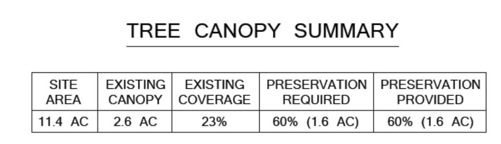
4 TRANSPORTATION ASSESSMENT: Existing Area Road Network and Conditions The Preliminary Plat proposes one private street with access onto E. Dove Rd. E. Dove Rd. (36) Between N. Kimball Ave. and N. Carroll Ave. West Bound East Bound 24hr 1,589 1,705 AM Peak 7:30 AM 8:30 AM (212) 7:45 AM 8:45 AM (160) PM Peak 5:00 PM - 6:00 PM (163) 5:15 PM - 6:15 PM (219) * Based on the 2014 City of Southlake Traffic Count Report Traffic Impact AM- AM- PM- PM- Use Lots Vtpd* IN OUT IN OUT Single Family Residential * Vehicle Trips Per Day * AM-In, AM-Out, PM-In and PM-Out are peak hour generators on a weekday * Based on the ITE: Trip Generation Manual, 7 th Edition WATER & SEWER: TREE PRESERVATION: CITIZEN INPUT/ BOARD REVIEW: PLANNING AND ZONING COMMISSION ACTION: The property will be served by an existing 12 water line and an 8 sewer line in E. Dove Rd. The Tree Conservation Plan shows that there is approximately 23% existing tree cover on the site, so Tree Preservation Ordinance No. 585-D requires a minimum of 60% of the existing canopy to be preserved. The applicant is proposing to preserve a minimum of 60% of the existing tree canopy. A SPIN meeting was not held for this case. November 5, 2015; A motion to approve the item subject to the staff report dated October 30, 2015 and Plat Review Summary No. 2, dated October 30, 2015, specifically approving the variance to Section 5.02 to allow a 40 right of way and a variance to Section 5.03, increasing the allowable deviation of a street intersecting with an arterial from 10 degrees to 25 degrees and the variance to Section 5.04 permitting the proposed street to be a private street, subject to the applicant bringing a full design of the gate and entryway to City Council and also recognizing the applicant s willingness to work with the neighbors to the east regarding a fence received a tie vote (2-2). A subsequent motion to approve the item subject to the staff report dated October 30, 2015 and Plat Review Summary No. 2, dated October 30, 2015, specifically approving all variances save and except the variance to Section 5.04 permitting the proposed street to be a private street and noting the applicant s willingness to work with the neighbors to the east regarding a fence was approved (4-0). STAFF COMMENTS: Attached is Revised Plat Review Summary No. 2, dated November 9, Attachment A ZA Page 2

5 . Attachment B ZA Page 1
6 PRELIMINARY PLAT Attachment C ZA Page 1

7 PROPOSED ENTRYWAY AND GATE FOR PRIVATE STREET Attachment C ZA Page 2

8 PROPOSED ENTRYWAY AND GATE FOR PRIVATE STREET Attachment C ZA Page 3
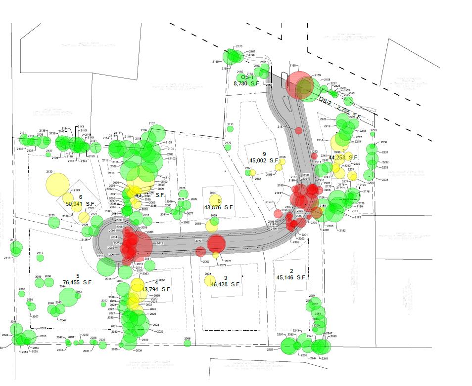
9 TREE PRESERVATION ANALYSIS Attachment C ZA Page 4
10 REVISED PLAT REVIEW SUMMARY : ZA Review No.: Two Date of Review: 11/09/15 Project Name: Preliminary Plat Kingdom Place APPLICANT: Clayton Redinger DEVELOPER: Michael Blubaugh DeOtte, Inc. KERG Equities, Ltd. 420 Johnson Rd. Ste Main St. Ste. 200 Keller, TX Fort Worth, TX Phone: (817) Phone: claytonredinger@deotte.com Fax: CITY STAFF HAS REVIEWED THE ABOVE REFERENCED PROJECT RECEIVED BY THE CITY ON 10/19/15 AND WE OFFER THE FOLLOWING STIPULATIONS. THESE STIPULATIONS ARE HEREBY MADE CONDITIONS OF PLAT APPROVAL UNLESS SPECIFICALLY AMENDED BY THE CITY COUNCIL. IF YOU HAVE ANY QUESTIONS OR NEED FURTHER CLARIFICATION, PLEASE CONTACT RICHARD SCHELL AT (817) A plat vacation is required to vacate the existing Lot 9, F. Throop No Addition and all easements that were dedicated by the plat. The plat vacation must be recorded with the County prior to the recording of a Final Plat. Please submit an application for a plat vacation. 2. Subdivision Ordinance No. 483, as amended, Section 5.03(C) requires that no street intersecting an arterial shall vary from a 90 degree angle of intersection by more than 10 degrees. A variance has been requested. 3. Subdivision Ordinance No. 483, as amended, requires a 50 right of way for local streets. A variance has been requested to allow a 40 right of way with 10 Pedestrian Access, Drainage and Utility Easements (P.A.D.U.E) on each side of the street. 4. Subdivision Ordinance No. 483, as amended, Section 5.04, does not permit private streets in new subdivisions in which less than 75% of the lots contain homeowner occupied structures. A variance has been requested to allow the proposed street to be a private street with gates. 5. The following changes are needed with regard to adjacent properties within 200' to include properties across any adjacent right of way: a. Correctly show and label the name of the record owner & corresponding deed record (volume & page for all unplatted tracts within 200 feet of this property. 6. The following changes are needed with regard to easements: a. Show and label the type, size and deed record of all existing easements on the property on the Final Plat. b. Provide easements for water, sewer and/or drainage in compliance with approved construction plans. c. Provide dimensional ties along lot lines to all easements. Provide centerline dimensions and bearings on any easements crossing areas if deflections occur. Attachment D ZA Page 1
11 d. Show via dotted lines any easements previously abandoned and label with deed record of abandonment (utility easements on Lot 9, F. Throop No Addition plat vacation). e. Put the detention pond in a drainage easement. kmartin@ci.southlake.tx.us Keith Martin Landscape Administrator Phone: (817) TREE CONSERVATION COMMENTS: Tree Conservation/Landscape Review 1. The Tree Conservation Plan shows that there is approximately 23% existing tree cover on the site, so Tree Preservation Ordinance No. 585-D requires a minimum of 60% of the existing canopy to be preserved. The applicant is proposing to preserve a minimum of 60% of the existing tree canopy. Except as provided by subsection 7.2.b. of the Tree Preservation Ordinance, a Tree Conservation Analysis or Tree Conservation Plan shall be approved if it will preserve existing tree cover in accordance with the percentage requirements established by Table 2.0. If the property has previously received a tree permit related to development, the percentage of existing tree cover at the time the first such permit was issued shall be used to calculate the minimum existing tree cover that must be preserved under this section. Table 2.0 Existing Tree Cover Preservation Requirements Percentage of existing tree cover on the entire site Minimum percentage of the existing tree cover to be preserved* 0% 20% 70% % 60% 40.1% - 60% 50% 60.1% - 80% 40% 80.1% - 100% 30% *The minimum percentage of existing tree cover to be preserved shall exclude any area in public rights-of-way as approved by City Council. * Please be aware that all existing trees shown to be preserved on the City Council approved Tree Conservation Plan must be preserved and protected during all phases and construction of the development. Alteration or removal of any of the existing trees shown to be preserved on the approved Tree Conservation Plan is a violation of the Tree Preservation Ordinance and the zoning as approved by the Southlake City Council. Please ensure that the layout of all structures, easements, utilities, structures grading, and any other structure proposed to be constructed do not conflict with existing trees intended to be preserved. LANDSCAPE COMMENTS: 1. A 10 B type bufferyard and the required plantings are required to be provided along E. Dove Road. Please show and label the required bufferyard on the Preliminary Plat. Attachment D ZA Page 2
12 * Indicates informational comment. # Indicates required items comment. Om Chhetri, P.E. Civil Engineer Phone: (817) ochhetri@ci.southlake.tx.us GENERAL COMMENTS: Public Works/Engineering Review 1. This review is preliminary. Additional requirements may be necessary with the review of civil construction plans. 2. Provide Traffic Impact Analysis threshold worksheet including calculations and site plan. 3. E. Dove Rd. is a 88 width ROW street per the City s thoroughfare plan. 4. Show proposed on-site and off-site sidewalks on the site plan. 5. The intersecting angle of Street A with Dove Rd shall not vary from a 90 degree angle by more than 10 degrees. Extend the Street A centerline and denote the angle if it varies from 90 degrees. A minimum of 50 tangent shall be provided between reverse curves on centerlines. A vaiance has been requested. 6. Show and label curb return radius for the proposed street. Label the distances to the nearest drives or street intersections in both directions from the proposed drive. * Street intersections shall comply with TDLR/ADA accessibility standards. * Sight distances shall comply with AASHTO guidelines on adjacent collectors and arterials. * Sidewalk widths shall conform to the Southlake Pathways Plan. * Use the City of Southlake GPS monuments whenever possible. Monument locations can be found in the City of Southlake website: EASEMENTS: 7. Provide all necessary easements for drainage. Easements shall be 15 minimum and located on one lot not centered on the property line. 8. Detention ponds shall be dedicated by plat as drainage easements. The following note shall be added to the plat: Compliance with the provisions of the city s Storm Drainage Policy does not relieve a person of the responsibility of complying with all other applicable laws, including, but not limited to, Section , Texas Water Code. 9. A drainage easement shall be required for the detention pond/s. 10. Provide corner clips at the intersection. Corner clips shall be shown on the plat. Refer to Ordinance No Attachment D ZA Page 3
13 * Water and sanitary sewer cannot cross property lines without being in an easement or right of way. WATER AND SEWER COMMENTS: 1. Single family residential developments require fire hydrant spacing of 400 maximum for non-sprinkled residences or 600 for sprinkled residences. * The size of the water service tap must match the size of the meter. There are no reducers allowed before the meter on the public side. A one inch meter must have a one inch tap, etc. * Water meters and fire hydrants shall be located in an easement or right of way. * Fire lines shall be separate from service lines. * All waterlines, sanitary sewer and storm sewer in easements or right of ways must be constructed to City standards. DRAINAGE COMMENTS: 1. Submit preliminary calculations used to size the detention pond. 2. Clearly label all private and public storm lines. 3. Differences between pre- and post- development runoff shall be captured in detention pond(s). Proposed detention ponds shall control the discharge of the 1, 10 and 100- year storm events. Detention may be required with any new proposed building construction. Describe how increased runoff from site is being detained. Access easements are needed for maintenance of detention ponds. 4. Easements outside of right of way shall be required for proposed storm sewer. Storm sewer must be installed outside the edge of pavement. Ordinance #605 defines easement requirements for storm sewer: 30 RCP and under - 15 easement RCP - 20 easement RCP - 25 easement RCP - 30 easement Over 102 RCP 3.5 times diameter 5. Verify size, shape, and/or location of the detention pond (as depicted on the site/concept/development plan). Any changes to size, shape, and/or location of the proposed pond(s) may require a revision to the concept/site/development plan and may need to be approved by the Planning and Zoning Commission and the City Council. 6. Driveway culvert must be sized by an engineer and submitted for approval to the City Engineer. * Calculations will be required to verify capacity of proposed curb inlets. * Storm sewers collecting runoff from public streets shall be RCP and constructed to City standards. * Discharge of post development runoff must have no adverse impact on downstream properties and meet the provisions of Ordinance No Attachment D ZA Page 4
14 INFORMATIONAL COMMENTS: * Submit 22 x34 civil construction plans and a completed Construction Plan Checklist directly to the Public Works Administration Department for review. Please allow 15 business days for review. The plans shall conform to the most recent construction plan checklist, standard details and general notes which are located on the City s website: * Submit with Civil Construction Plans a Storm Water Pollution Prevention Plan which outlines preconstruction, construction and post-construction erosion control measures. Provide Stormwater Pollution Prevention Plan per TXR The plan must include all required elements in Part III, Section F of the permit. The City of Southlake especially reviews Part III, Section F, (1) (g), Maps. The review is for completeness of a plan to prevent pollution (especially sediment) to the Separate Storm Sewer System. It is highly recommended the project manager provide a series of maps for complex projects, including one map showing controls during mass grading and infrastructure, one map showing controls during vertical construction, and one map showing final stabilization (may be but not always equitable to the landscape plan). Please include timelines in relation to the project activities for installation and removal of controls. SWPPP shall be submitted by second review of the civil construction plans. * Retaining walls greater than 4-feet including the footing shall require structural plans prepared by a registered engineer in the State of Texas. Retaining walls shall require a permit from the Building Inspections Department prior to construction. * A geotechnical report will be required for all private and public roadways. The geotechnical report shall include pavement design parameters for subgrade stabilization. * A right of way permit shall be obtained from the Public Works Operations Department (817) to connect to the City s sewer, water or storm sewer system. * A Developer Agreement may be required for this development and may need to be approved by the City Council prior to any construction of public infrastructure. Construction plans for these improvements must be acceptable to Public Works prior to placing the Developer s Agreement on the City Council agenda for consideration. * Any hazardous waste being discharged must be pretreated per Ordinance No *=Denotes informational comment. Kelly Clements Assistant Fire Marshal Phone: (817) kclements@ci.southlake.tx.us GENERAL COMMENTS: Fire Department Review Subdivision street name needs to be approved by city prior to final plat. Submit proposed name and alternate names as soon as possible. Fire apparatus access needs to be designed and maintained to support the imposed loads of fire apparatus (minimum of 85,000 lbs GVW). Fire access roads must be at least 31 ft. back of curb to back of curb. (Standard street width) Attachment D ZA Page 5
15 Hydrants maximum spacing for R-3 Occupancies is 400 feet for subdivisions with un-sprinkled homes. Hydrants are required at intersecting streets and at intermediate locations between as prescribed above, measured as the hose would be laid. (Add a fire hydrant at Dove Road and Street A for proper coverage) Cul-de-Sacs must have 30 ft. inside turn radius and 50 foot radius (100 foot diameter) for an approved turnaround. ============= The following should be informational comments only ==================== * A Developers Agreement is required prior to construction of any public infrastructure. The Developer's Agreement for this addition should consider streets, drainage, park dedication requirements and fees, off-site sewer extensions, off-site drainage and utility easements and impact fees. * All development must comply with the Drainage Ordinance No. 605 and the Erosion and Sediment Control Ordinance No. 946, as amended. * Although there are a few lot lines which are not perpendicular or radial, they appear to meet the intent of this requirement. * Fencing and screening along E. Dove R. (an arterial) must comply with Zoning Ordinance No 480, as amended, Section 39.5.c.4.i requiring the fence to be constructed of masonry, ornamental metal or wrought iron, or stained board-on-board with cap and masonry columns with a maximum of 14 feet from column center to column center or some combination of the above if approved by the Administrative Official. * Park dedication fees will be required for the additional residential lots being created. Attachment D ZA Page 6

16 SURROUNDING PROPERTY OWNERS Kingdom Place SPO Owner Zoning Physical Address Acreage Response # 1. SHINER, TIMOTHY SF1-A 1643 CREEKSIDE DR 1.22 NR 2. HARGADINE, G W EST SF1-A 1967 E DOVE RD NR 3. DAVIS, CHRISTOPHER M SF1-A 2023 E DOVE RD 0.88 NR 4. BACON, JERRY B SF1-A 2040 E DOVE RD 0.56 O 5. CATE, MABEL EST SF1-A 2050 E DOVE RD 2.12 NR 6. DECARO, THOMAS SF1-A 2080 E DOVE RD 7.57 F 7. LONG, PAMELA D SF1-A 2117 E DOVE RD 2.99 NR 8. BABARIA, ASHWIN J SF1-A 1470 N KIMBALL AVE 0.85 NR 9. HORRAL, BRENDA KAY SF1-A 1460 N KIMBALL AVE 1.76 NR 10. IDOSKI, GAZIM SF1-A 2000 E DOVE RD 0.27 NR 11. WAYMAN, LANCE SF1-A 2010 E DOVE RD 1.06 NR 12. IDOSKI, GAZIM SF1-A 2000 E DOVE RD 0.10 NR 13. BABARIA, ASHWIN J SF1-A 1470 N KIMBALL AVE 3.67 NR 14. BABARIA, ASHWIN J SF1-A 1468 N KIMBALL AVE 1.54 NR 15. BABARIA, ASHWIN J SF1-A 1462 N KIMBALL AVE 1.96 NR 16. BABARIA, ASHWIN J SF1-A 1470 N KIMBALL AVE 0.30 NR 17. WARD, DONNIE W C E DOVE RD 0.93 NR Attachment E ZA Page 1
17 18. WAGNER, PAUL C N KIMBALL AVE 0.68 NR 19. WAGNER, PAUL SF1-A 1480 N KIMBALL AVE 0.55 NR 20. WAGNER, PAUL SF1-A 1480 N KIMBALL AVE 0.56 NR 21. LONG, PAMELA D SF1-A 2150 E DOVE RD 1.04 NR 22. WAGNER, PAUL SF1-A 1480 N KIMBALL AVE 0.98 NR 23. MCPHERSON, RICKEY C E DOVE RD 0.55 NR 24. BERLIN, SCOTT A SF1-A 1265 STANHOPE CT 1.03 NR 25. JOHNSON, DOUG SF1-A 1255 STANHOPE CT 0.96 NR 26. MCPHERSON, RICKEY SP N KIMBALL AVE 3.16 NR 27. COLLIER, JAMES D SF1-A 2100 E DOVE RD 1.58 NR 28. RANDOLPH, KAREN AG 2034 E DOVE RD 1.26 NR Responses: F: In Favor O: Opposed To U: Undecided NR: No Response Notices sent: Twenty-eight (28) Responses received: Two (2) Attached Attachment E ZA Page 2

18 Attachment E ZA Page 3

19 Attachment E ZA Page 4
Department of Planning & Development Services
 Department of Planning & Development Services S T A F F R E P O R T CASE NO: ZA15-042 May 29, 2015 PROJECT: Preliminary Plat for Moss Farms EXECUTIVE SUMMARY: REQUEST DETAILS: Horton Capital Partners is
Department of Planning & Development Services
 Department of Planning & Development Services S T A F F R E P O R T February 9, 2015 CASE NO: PROJECT: EXECUTIVE SUMMARY: ZA14-154 Plat Revision for Lots 25R-1A, 25R-1B and 25R-1C, Block 1, Woodland Heights
Department of Planning & Development Services
 Department of Planning & Development Services S T A F F R E P O R T December 30, 2015 CASE NO: PROJECT: EXECUTIVE SUMMARY: REQUEST DETAILS: ZA15-136 Site Plan for Ward Retail Building On behalf of Donnie
Department of Planning & Development Services
 Department of Planning & Development Services S T A F F R E P O R T April 17, 2014 CASE NO: PROJECT: EXECUTIVE SUMMARY: DETAILS: ZA14-038 Site Plan for Abundant Grace Church Abundant Grace Church is requesting
Department of Planning & Development Services
 Department of Planning & Development Services S T A F F R E P O R T November 14, 2014 CASE NO: ZA14-132 PROJECT: Preliminary Plat for Edwards Park Addition Lots 1 and 2 EXECUTIVE SUMMARY: Clayton and Clayton
Department of Planning & Development Services
 Department of Planning & Development Services S T A F F R E P O R T May 13, 2016 CASE NO: PROJECT: EXECUTIVE SUMMARY: DETAILS: ZA16-029 Zoning Change and Development Plan for the Carillon Corporate District
Department of Planning & Development Services
 Department of Planning & Development Services S T A F F R E P O R T May 16, 2014 CASE NO: PROJECT: EXECUTIVE SUMMARY: DETAILS: ZA14-047 Zoning Change and Development Plan for Fusella Property Four Peaks-RM,
Department of Planning & Development Services
 Department of Planning & Development Services S T A F F R E P O R T December 30, 2015 CASE NO: PROJECT: EXECUTIVE SUMMARY: REQUEST DETAILS: ZA15-136 Site Plan for Ward Retail Building On behalf of Donnie
Department of Planning & Development Services
 Department of Planning & Development Services S T A F F R E P O R T July 11, 2014 CASE NO: PROJECT: EXECUTIVE SUMMARY: DETAILS: ZA14-070 Southlake Professional Park On behalf of Bootstrap Investments,
Department of Planning & Development Services
 Department of Planning & Development Services S T A F F R E P O R T June 9, 2015 CASE NO: ZA15-048 PROJECT: Preliminary Plat for Southlake Town Square Phase IV (Granite Place) EXECUTIVE SUMMARY: Cooper
Department of Planning & Development Services
 Department of Planning & Development Services S T A F F R E P O R T December 30, 2015 CASE NO: PROJECT: REQUEST: DETAILS: ZA15-134 Preliminary Plat for Lots 2R1 & 2R2 H. Granberry No. 581 Addition (Option
Department of Planning & Development Services
 Department of Planning & Development Services STAFF REPORT March 14, 2014 CASE NO: PROJECT: EXECUTIVE SUMMARY: REQUEST: ZA13-137 Zoning Change and Site Plan for Feedstore BBQ William Lafavers, owner of
Department of Planning & Development Services
 Department of Planning & Development Services S T A F F R E P O R T April 27, 2016 CASE NO: ZA15-151 PROJECT: REQUEST: Preliminary Plat for Saddleback Ridge Estates Spectra Land is requesting approval
FINAL SUBDIVISION AND LAND DEVELOPMENT PLAN CHECKLIST. Plan Name. Applicant's Name:
 TOWNSHIP OF UPPER ST. CLAIR FINAL SUBDIVISION AND LAND DEVELOPMENT PLAN CHECKLIST Date Filed Plan Name PLC Applicant's Name: Phone Filing Date for Final Application Final Plat 114.22. FINAL APPLICATION
M E M O R A N D U M. Planning and Zoning Commission. Daniel Turner, Planner I
 M E M O R A N D U M Meeting Date: Monday, April 10, 2017 Item No. F-4 To: From: Planning and Zoning Commission Daniel Turner, Planner I Subject: Consider a recommendation of a Preliminary Site Evaluation
Department of Planning & Development Services
 Department of Planning & Development Services S T A F F R E P O R T April 28, 2015 CASE NO: PROJECT: EXECUTIVE SUMMARY: REQUEST DETAILS: ZA14-131 Zoning Change and Development Plan for Edwards Park Addition
Department of Planning & Development Services
 Department of Planning & Development Services S T A F F R E P O R T December 10, 2013 CASE NO: PROJECT: EXECUTIVE SUMMARY: DETAILS: ZA13-126 Zoning Change and Concept Plan for Chesapeake Place Addition
SUBDIVISION APPLICATION
 SUBDIVISION APPLICATION Preliminary Plat Minor Plat Final Plat Amended Plat Applicant Name: Owner (if different from applicant) Name: Company: Company: Address: Address: City, State, Zip City, State, Zip
Section Preliminary Plat Checklist and Application Forms
 Section 201 - Preliminary Plat Checklist and Application Forms PRELIMINARY SUBDIVISION PLAT REVIEW PROCESS CHART PRELIMINARY SUBDIVISION PLAT APPLICATION PRELIMINARY PLAT REVIEW CHECKLIST CITY OF NAMPA
Department of Planning & Development Services
 Department of Planning & Development Services S T A F F R E P O R T May 10, 2016 CASE NO: PROJECT: EXECUTIVE SUMMARY: REQUEST DETAILS: ZA16-015 Zoning Change and Concept Plan / Site Plan for St. Laurence
MINOR PLAT. The following documents are provided as required by the City of Conroe for use in the above titled platting submittals:
 Public Works - Engineering Division CITY OF CONROE MINOR PLAT The following documents are provided as required by the City of Conroe for use in the above titled platting submittals: Submittal Questionnaire
JEFFERSON COUNTY, ALABAMA
 JEFFERSON COUNTY, ALABAMA Major Development Checklist, Notes and Information A Major Development is any proposed new structure or addition to an existing structure which will cause a change in the topography
DAUPHIN CREEK ESTATES SUBDIVISION
 # 12 SUB-000076-2017 DAUPHIN CREEK ESTATES SUBDIVISION Engineering Comments: FINAL PLAT COMMENTS (should be addressed prior to submitting the FINAL PLAT for review and/or signature by the City Engineer):
WESTMINSTER PARK PLACE SUBDIVISION
 WESTMINSTER PARK PLACE SUBDIVISION Engineering Comments: FINAL PLAT COMMENTS (should be addressed prior to submitting the FINAL PLAT for review and/or signature by the City Engineer): A. Provide all of
APPLICATION PROCEDURE
 ANTRIM PLANNING BOARD P. O. Box 517 Antrim, New Hampshire 03440 Phone: 603-588-6785 FAX: 603-588-2969 APPLICATION FORM AND CHECKLIST FOR MINOR OR MAJOR SITE PLAN REVIEW File Date Received By APPLICATION
PRELIMINARY PLATS. The following documents are provided as required by the City of Conroe for use in the above titled platting submittals:
 Public Works Engineering Division CITY OF CONROE PRELIMINARY PLATS The following documents are provided as required by the City of Conroe for use in the above titled platting submittals: Submittal Questionnaire
Department of Planning & Development Services
 Department of Planning & Development Services S T A F F R E P O R T October 12, 2015 CASE NO: PROJECT: ZA15-101 Zoning Change & Site Plan for Zoe s Kitchen Awnings at Kimball Crossing EXECUTIVE SUMMARY:
City of Colleyville City Council Agenda Briefing
 City of Colleyville City Council Agenda Briefing City Hall 100 Main Street Colleyville, Texas 76034 www.colleyville.com Agenda Number 5a Agenda Date 01/06/2015 Number Ordinance O-14-1942 Type Ordinance
ARTICLE 900 PLAT AND PLAN REQUIREMENTS
 ARTICLE 900 PLAT AND PLAN REQUIREMENTS SEC. 900.1 ITEMS TO BE SHOWN ON PLAT OR PLAN General (1) Property lines of all property owners adjacent to the exterior boundaries of the project shall be located
WESTMINSTER PARK SUBDIVISION
 WESTMINSTER PARK SUBDIVISION Engineering Comments: FINAL PLAT COMMENTS (should be addressed prior to submitting the FINAL PLAT for review and/or signature by the City Engineer): A. Provide all of the required
APPLICATION FOR MAJOR SUBDIVISION APPROVAL (PRELIMINARY PLAT)
") 209 S. Main Street Marysville, Ohio 43040 Phone: (937) 645-7350 Fax: (937) 645-7351 www.marysvilleohio.org APPLICATION FOR MAJOR SUBDIVISION APPROVAL (PRELIMINARY PLAT) *** IMPORTANT INFORMATION ~ Please
209 S. Main Street Marysville, Ohio 43040 Phone: (937) 645-7350 Fax: (937) 645-7351 www.marysvilleohio.org APPLICATION FOR MAJOR SUBDIVISION APPROVAL (PRELIMINARY PLAT) *** IMPORTANT INFORMATION ~ Please
TOWN OF NORTHWOOD, NEW HAMPSHIRE
 TOWN OF NORTHWOOD, NEW HAMPSHIRE OFFICE OF THE PLANNING BOARD 818 First New Hampshire Turnpike, Northwood NH 03261 (603)942-5586 Extension 205 Facsimile: (603)942-9107 Major Subdivision Application Form
SUBDIVISION APPLICATION CHECKLIST SKETCH PLAN PRELIMINARY PLAT FINAL PLAT
 RECEIVED STAMP SUBDIVISION APPLICATION CHECKLIST SKETCH PLAN PRELIMINARY PLAT FINAL PLAT A checklist of background information and submission requirements for processing of a sketch plan, preliminary plat
Residential Major Subdivision Review Checklist
 Residential Major Subdivision Review Checklist Plan Submittal Requirements: 2 full sets of stamped plans Electric submittal - all plans contained in a single PDF 3 full sets if commercial kitchen or dining
géãç Éy VtÇtÇwt zât 5440 Routes 5 & 20 West Canandaigua, NY Phone: (585) / Fax: (585)
 / Fax: (585)") géãç Éy VtÇtÇwt zât 5440 Routes 5 & 20 West Canandaigua, NY 14424 Phone: (585) 394-1120 / Fax: (585) 394-9476 APPLICATION FOR LOT-LINE ADJUSTMENT The applicant is responsible for the completeness of all
géãç Éy VtÇtÇwt zât 5440 Routes 5 & 20 West Canandaigua, NY 14424 Phone: (585) 394-1120 / Fax: (585) 394-9476 APPLICATION FOR LOT-LINE ADJUSTMENT The applicant is responsible for the completeness of all
Department of Planning & Development Services
 Department of Planning & Development Services S T A F F R E P O R T January 14, 2015 CASE NO: PROJECT: EXECUTIVE SUMMARY: REQUEST DETAILS: ZA14-131 Zoning Change and Concept Plan for Edwards Park Addition
ARTICLE 24 PRIVATE ROAD, SHARED PRIVATE DRIVEWAY AND ACCESS EASEMENT STANDARDS
 ARTICLE 24 PRIVATE ROAD, SHARED PRIVATE DRIVEWAY AND ACCESS EASEMENT STANDARDS SECTION 24.00 INTENT AND PURPOSE The standards of this Article provide for the design, construction and maintenance of private
PLANNED UNIT DEVELOPMENT & SUBDIVISION STAFF REPORT Date: April 18, 2019
 PLANNED UNIT DEVELOPMENT & SUBDIVISION STAFF REPORT Date: April 18, 2019 DEVELOPMENT NAME SUBDIVISION NAME Springhill Village Subdivision Springhill Village Subdivision LOCATION 4350, 4354, 4356, 4358,
Township of Little Egg Harbor Planning Board 665 Radio Road Little Egg Harbor, New Jersey Phone: ext. 221 Fax:
 BLOCK(S) LOT(S) Township of Little Egg Harbor Planning Board 665 Radio Road Little Egg Harbor, New Jersey 08087 Phone: 609-296-7241 ext. 221 Fax: 609-294-3040 Development Application Amended Development
ARTICLE IV: DEVELOPMENT STANDARDS
 ARTICLE IV: DEVELOPMENT STANDARDS IV-53 409 PRIVATE STREETS A private street means any way that provides ingress to, or egress from, property by means of vehicles or other means, or that provides travel
Initial Subdivision Applications Shall Include the Following:
 Initial Subdivision Applications Shall Include the Following: 1) Subdivision Application Form: completely filled out (12 copies) 2) Plat: The Plat must adhere to the requirements set forth in the Town
BRIDGETON SUBDIVISION APPLICATION CHECKLIST
 APPLICATION NAME AND # CHECKLIST COMPLETED BY: DATE: Signature and printed name BRIDGETON SUBDIVISION APPLICATION CHECKLIST TO SUBDIVISION APPLICANTS: The attached checklist is to assist you in the submission
Residential Minor Subdivision Review Checklist
 Residential Minor Subdivision Review Checklist Plan Submittal Requirements: 2 full sets of stamped plans Electric submittal - all plans contained in a single PDF 3 full sets if commercial kitchen or dining
Subdivision - Minor Plat Submittal
 Subdivision - Minor Plat Submittal This Checklist is intended to provide the information and data that is necessary to assess the merits of the project proposal. Please note that this Checklist is intended
CITY OF SARALAND PRELIMINARY SUBDIVISION PLAT REVIEW
 PRELIMINARY SUBDIVISION PLAT REVIEW Application Number: Date Plat Submitted: Name of Subdivision: Name of Owner: Owner Address: (Street or P.O. Box) Telephone #: (City) (State) (Zip) E-mail: Name of Authorized
APPLICATION SUBMITTAL REQUIREMENTS FOR Tentative Parcel or Subdivision Maps
 CITY OF EL CERRITO Community Development Department Planning and Building Division 10890 San Pablo Avenue, El Cerrito, CA 94530 (510) 215-4330 FA (510) 233-5401 planning@ci.el-cerrito.ca.us APPLICATION
ORDINANCE NO. Be it ordained by the City Council of the City of Abilene, Texas:
 ORDINANCE NO. An ordinance repealing Chapter 23, Subpart B of the Code of the City of Abilene, Texas, entitled Mobile Homes and Vacation Travel Trailers; stating the authority; setting forth the scope
Department of Planning & Development Services
 Department of Planning & Development Services S T A F F R E P O R T May 31, 2016 CASE NO: PROJECT: EXECUTIVE SUMMARY: DETAILS: ZA16-027 Zoning Change and Site Plan for S. H. 114 & Blessed Way Integrated
COMMERCIAL SITE PLAN & CONDITIONAL USE PERMIT REVIEW PROCESS & CHECKLIST
 Community Development 110 South Main Street Springville, UT 84663 COMMERCIAL SITE PLAN & CONDITIONAL USE PERMIT REVIEW PROCESS & CHECKLIST 801.491.7861 www.springville.org Prior to the issuance of a building
Cobb County Community Development Agency Zoning Division 1150 Powder Springs St. Marietta, Georgia 30064
 Cobb County Community Development Agency Zoning Division 1150 Powder Springs St. Marietta, Georgia 30064 Case # Z-63 Public Hearing Dates: PC: 11-06-18 BOC: 11-20-18 SITE BACKGROUND Applicant: Loyd Development
Preliminary Subdivision Application (Major) (Four (4) lots or more)
 (Four (4) lots or more)") Gunnison City Offices www.gunnisoncity.org 38 West Center Gunnison, Utah 84634 (435) 528 7969 Date of Application: Preliminary Subdivision Application (Major) (Four (4) lots or more) APPLICANT INFORMATION
Gunnison City Offices www.gunnisoncity.org 38 West Center Gunnison, Utah 84634 (435) 528 7969 Date of Application: Preliminary Subdivision Application (Major) (Four (4) lots or more) APPLICANT INFORMATION
Department of Planning & Development Services
 Department of Planning & Development Services S T A F F R E P O R T May 13, 2016 CASE NO: PROJECT: EXECUTIVE SUMMARY: REQUEST DETAILS: ZA16-008 Zoning Change and Site Plan for KLA School On behalf of Mani
Department of Planning & Development Services
 Department of Planning & Development Services S T A F F R E P O R T November 13, 2013 CASE NO: PROJECT: EXECUTIVE SUMMARY: DETAILS: ACTION NEEDED: ZA13-128 Zoning Change and Site Plan for Kimball Lake
MINOR SUBDIVISION PLAT CHECKLIST
 MINOR SUBDIVISION PLAT CHECKLIST Project Name: Tax ID #: Project Number: Date: _ Reviewed By: Telephone: NOTES: All lots on septic systems must comply with the Fulton County Health Department requirements
ARTICLE 900 PLAT AND PLAN REQUIREMENTS
 Final SEC. 900.01 ARTICLE 900 PLAT AND PLAN REQUIREMENTS General provisions. (a) Scale. The scale of all plats and plans shall be a minimum of 1 to 100 ft. (b) Size. The minimum page size for all plats
Department of Planning & Development Services
 Department of Planning & Development Services STAFF REPORT March 26, 2014 CASE NO: PROJECT: EXECUTIVE SUMMARY: REQUEST: ZA13-137 Zoning Change and Site Plan for Feedstore BBQ William Lafavers, owner of
Exhibit A-1. Piney Creek Bend Planned Development
 Exhibit A-1 Piney Creek Bend Planned Development A. Purpose and Intent The Piney Creek Bend PD is composed of approximately 90.91 acres, as described in Exhibit D (Field Notes). The development of this
NOT TO BE SUBMITTED WITH SKETCH DESIGN APPROVAL Subdivision Checklist: Major Subdivision Final Plat
 Must be received with review fee (equal to $200.00, plus $25.00 per lot) no later than 15 days prior to Planning Board meeting, which is normally the first Monday of the month (certain holidays may modify
CITY OF OCOEE LAND DEVELOPMENT CODE SUFFICIENCY TABLE WITH NOTES
 CITY OF OCOEE LAND DEVELOPMENT CODE SUFFICIENCY TABLE WITH NOTES The Sufficiency Table is a checklist to help identify the types of information and documentation needed for various types of projects. The
KEIZER COMMUNITY DEVELOPMENT DEPARTMENT STAFF RECOMMENDATION Subdivision Case No
 KEIZER COMMUNITY DEVELOPMENT DEPARTMENT STAFF RECOMMENDATION Subdivision Case No. 2014-01 TO: FROM: Cynthia Domas, Keizer Hearings Officer Sam Litke, Senior Planner SUBJECT: Subdivision Case No. 2014-01
PLANNING COMMISSION REPORT REGULAR AGENDA. PC Staff Report 08/25/10 ITEM NO 6: PRELIMINARY PLAT; HALLMARK ADDITION; ACRES; 151 MCDONALD DR (MKM)
") PP-6-6-10 Item No. 6-1 PLANNING COMMISSION REPORT REGULAR AGENDA PC Staff Report 08/25/10 ITEM NO 6: PRELIMINARY PLAT; HALLMARK ADDITION; 5.252 ACRES; 151 MCDONALD DR (MKM) PP-6-6-10: Consider a Preliminary
PP-6-6-10 Item No. 6-1 PLANNING COMMISSION REPORT REGULAR AGENDA PC Staff Report 08/25/10 ITEM NO 6: PRELIMINARY PLAT; HALLMARK ADDITION; 5.252 ACRES; 151 MCDONALD DR (MKM) PP-6-6-10: Consider a Preliminary
E L M E R B O R O U G H L A N D U S E B O A R D APPLICATION COVER SHEET (to be completed for all applications and appeals)
") E L M E R B O R O U G H L A N D U S E B O A R D APPLICATION COVER SHEET (to be completed for all applications and appeals) 1. Name(s): 2. Address: 3. Telephone Number(s): 4. E-mail: 5. Owner Name(s) (if
E L M E R B O R O U G H L A N D U S E B O A R D APPLICATION COVER SHEET (to be completed for all applications and appeals) 1. Name(s): 2. Address: 3. Telephone Number(s): 4. E-mail: 5. Owner Name(s) (if
Operating Standards Attachment to Development Application
 Planning & Development Services 2255 W Berry Ave. Littleton, CO 80120 Phone: 303-795-3748 Mon-Fri: 8am-5pm www.littletongov.org Operating Standards Attachment to Development Application 1 PLANNED DEVELOPMENT
CITY OF HOBBS ORDINANCE NO..
 CITY OF HOBBS ORDINANCE NO.. AN ORDINANCE TO AMEND TITLE 16 OF THE HOBBS MUNICIPAL CODE IN ITS ENTIRETY. BE IT ORDAINED BY THE GOVERNING BODY OF THE CITY OF HOBBS, NEW MEXICO, that the following Chapter
TOWN OF EASTCHESTER BUILDING AND PLANNING DEPARTMENT PLANNING BOARD APPLICATION PACKAGE SUBDIVISIONS
 TOWN OF EASTCHESTER BUILDING AND PLANNING DEPARTMENT 40 Mill Road (914) 771-3317 building@eastchester.org Eastchester, NY 10709 (914) 771-3322 Fax www.eastchester.org TABLE OF CONTENTS PLANNING BOARD APPLICATION
Final Plat Mapping Requirements
 CURRENT PLANNING DIVISION 410 E. 5 th Street Loveland, CO 80537 970-962-2523 eplan-planning@cityofloveland.org cityofloveland.org/dc Final Plat Mapping Requirements All Final plats shall comply with the
PRELMINARY PLAT CHECKLIST
 PRELMINARY PLAT CHECKLIST A. All preliminary plat submitted for approval shall be prepared by a Registered Professional Land Surveyor. B. Preliminary plats must be drawn to a scale of XXX with such accuracy
MONTGOMERY COUNTY PLANNING DEPARTMENT THE MARYLAND-NATIONAL CAPITAL PARK AND PLANNING COMMISSION
 MONTGOMERY COUNTY PLANNING DEPARTMENT THE MARYLAND-NATIONAL CAPITAL PARK AND PLANNING COMMISSION MCPB Item No.: Date: 06-21-12 The Plantations, Preliminary Plan -120090240 Benjamin Berbert, Senior Planner,
Department of Planning & Development Services
 Department of Planning & Development Services S T A F F R E P O R T October 27, 2015 CASE NO: PROJECT: EXECUTIVE SUMMARY: REQUEST DETAILS: ZA15-104 Zoning Change and Site Plan for Lowe s On behalf of Lowe
The Filing Fee for a Minor Plat is $ PLUS $20.00 per lot created
 DEPARTMENT OF COMMUNITY DEVELOPMENT MINOR PLAT PROCEDURE The Filing Fee for a Minor Plat is $250.00 PLUS $20.00 per lot created Description: The purpose of a Minor Plat is to allow property to be platted
HERON LANDING SUBDIVISION
 HERON LANDING SUBDIVISION Engineering Comments: Per FEMA guidelines, any development greater than 5 acres in size or subdivision 50 lots in size, requires a flood study. Width of drainage easement to be
CHAPTER 22 SUBDIVISION AND LAND DEVELOPMENT
 CHAPTER 22 SUBDIVISION AND LAND DEVELOPMENT 22-101. Title 22-102. Legislative Intent Part 1 General Provisions 22-201. Development Permits Part 2 Administration 22-301. Fee Schedule Part 3 Fee Schedule
I. Requirements for All Applications. C D W
 108-16.1. Application checklists. Checklist for Required Submissions to the Planning Board or Zoning Board of Adjustment of Monroe Township All required submissions are to be made to the Administrative
Staff Report to the North Ogden Planning Commission
 Staff Report to the North Ogden Planning Commission SYNOPSIS / APPLICATION INFORMATION Application Request: Consideration and action on an administrative application for final approval for the Legacy North
610 LAND DIVISIONS AND PROPERTY LINE ADJUSTMENTS OUTSIDE A UGB
 ARTICLE VI: LAND DIVISIONS AND PROPERTY LINE ADJUSTMENTS VI-21 610 LAND DIVISIONS AND PROPERTY LINE ADJUSTMENTS OUTSIDE A UGB 610-1 Property Line Adjustments (Property Line Relocation) A property line
PLANNED UNIT DEVELOPMENT & SUBDIVISION STAFF REPORT Date: November 17, 2016
 PLANNED UNIT DEVELOPMENT & SUBDIVISION STAFF REPORT Date: November 17, 2016 DEVELOPMENT NAME SUBDIVISION NAME LOCATION Autonation Ford of Mobile Autonation Ford of Mobile Subdivision 901, 909, and 925
Site Plan Application
 Site Plan Application City of St. Pete Beach Community Development Department 155 Corey Avenue St. Pete Beach, Florida 33706 (727) 367-2735 www.stpetebeach.org Case Number: PROPERTY OWNER: Name: Address:
SUBDIVISION DESIGN PRINCIPLES AND STANDARDS
 SECTION 15-200 SUBDIVISION DESIGN PRINCIPLES AND STANDARDS 15-201 STREET DESIGN PRINCIPLES 15-201.01 Streets shall generally conform to the collector and major street plan adopted by the Planning Commission
ARTICLE 3 DEFINITIONS
 Sections: 3-1 Rules of Construction 3-2 Definitions ARTICLE 3 DEFINITIONS SECTION 3-1 RULES OF CONSTRUCTION 3-101. a. The language set forth in these regulations shall be interpreted in accordance with
Department of Planning & Development Services
 Department of Planning & Development Services S T A F F R E P O R T August 27, 2014 CASE NO: ZA14-029 PROJECT: Zoning Change and Site Plan for Lots 5R1, 5R2 and 4, T. Easter No. 474 Addition EXECUTIVE
SUBDIVISION AND LAND DEVELOPMENT. 185 Attachment 20
 185 Attachment 20 APPENDIX S Plat No. Date of Submission Twp. Fee $ Dauphin Co. Fee $ TOWNSHIP OF DERRY SUBDIVISION OR LAND DEVELOPMENT PLAN SUBMISSION APPLICATION This block for Twp. use only 1. Title
DIVISION 2 - CONSTRUCTION PLAN AND MISCELLANEOUS REQUIREMENTS
 DIVISION 2 - CONSTRUCTION PLAN AND MISCELLANEOUS REQUIREMENTS 2.1 Required Plan Sheets 2.2 Drawing Requirements 2.3 Graphic Standards 2.4 Easements 2.5 Utility Locations 2.6 Private Facility Locations
Major Subdivision Application Packet. Revised June 2018
 Major Subdivision Application Packet Revised June 2018 Caroline County Department of Planning and Community Development 233 West Broaddus Avenue Bowling Green, VA 22427 www.co.caroline.va.us Phone: 804-633-4303
FINAL PLAT APPLICATION
 FINAL PLAT APPLICATION (Page 1 of 3) LEGAL OWNER(s): NAME: STREET ADDRESS OWNER(s): CITY, STATE, ZIP CODE: PHONE NUMBER: BILLING ADDRESS: NAME OF ENGINEER/SURVEYOR: Engineer/Surveyor Address, Phone: PROPERTY
Condominium Unit Requirements.
 ARTICLE 19 CONDOMINIUM REGULATIONS Section 19.01 Purpose. The purpose of this Article is to regulate projects that divide real property under a contractual arrangement known as a condominium. New and conversion
Staff Report to the North Ogden City Council
 Staff Report to the North Ogden City Council SYNOPSIS / APPLICATION INFORMATION Application Request: Consideration and action on an administrative application to provide comments on the preliminary plan
ARTICLE 23 CONDOMINIUM STANDARDS
 ARTICLE 23 CONDOMINIUM STANDARDS Section 23.01 Intent. The intent of this Article is to provide regulatory standards for condominiums and site condominiums similar to those required for projects developed
SUBMITTAL REQUIREMENTS
 PRELIMINARY PLAT APPLICATION ***A PRE-APPLICATION MEETING WITH CITY STAFF IS REQUIRED FOR THIS APPLICATION*** DATE STAMP FOR CITY USE ONLY PROJECT NAME (if any): TO BE FILLED OUT BY APPLICANT PROJECT STREET
PLYMOUTH PLANNING BOARD APPLICATION FOR A MINOR SUBDIVISION OR MAJOR SUBDIVISION
 CASE # PLYMOUTH PLANNING BOARD APPLICATION FOR A MINOR SUBDIVISION OR MAJOR SUBDIVISION The undersigned Applicant hereby submits to the Plymouth Planning Board a completed application for a proposed minor
SUBJECT PARCEL(S) Property Owner(s) TMS Number Approximate Acreage Carolina Park Development, LLC
 Property Owner(s) TMS Number Approximate Acreage Carolina Park Development, LLC") Staff Report Special Planning Commission Meeting November 19, 2014 For reference, the Zoning Code and Land Development Regulations are available online. AGENDA ITEM 5c. SKETCH PLAN APPROVAL REQUEST: Request
Staff Report Special Planning Commission Meeting November 19, 2014 For reference, the Zoning Code and Land Development Regulations are available online. AGENDA ITEM 5c. SKETCH PLAN APPROVAL REQUEST: Request
CHAPTER 32 SUBDIVISIONS SECTION TITLE PAGE NO.
 Page 1 of 46 CHAPTER 32 SUBDIVISIONS SECTION TITLE PAGE NO. SECTION 32-1 Purpose of Ordinance 3 SECTION 32-2 Definitions 3 SECTION 32-3 Staff Sketch Review 4 SECTION 32-4 Subdivision and PUD Plats Required
Chapter 22 LAND USE* Article III. Subdivisions
 Chapter 22 LAND USE* Article III. Subdivisions Sec. 22-256. Authority to Regulate. Sec. 22-257. Scope; plat required. Sec. 22-258. Definitions. Sec. 22-259. Interpretations and Meanings. Sec. 22-260. Procedure
Committed to Service. License Agreement Application Form
 Committed to Service License Agreement Application Form PLEASE NOTE: Effective February 16, 2010 - License Agreements within the downtown Boise area for public structures, objects and uses on ACHD sidewalks
MAPLETON CITY CORPORATION. Step 7: Upon final approval and prior to plat recording the applicant shall provide the following:
 MAPLETON CITY CORPORATION Subdivision Process The City s subdivision requirements are designed to facilitate orderly, safe and efficient development and to implement the adopted General Plan. Below is
APPENDIX B. SUBMISSION REQUIREMENTS
 Master Major Site Minor Site Landscape Section B.1 Table of /Plat Requirements Proposed or approved name of development, project, subdivision, and/or phase. Location, including township, county, and state.
Department of Planning & Development Services
 Department of Planning & Development Services S T A F F R E P O R T August 29, 2014 CASE NO: PROJECT: EXECUTIVE SUMMARY: DETAILS: ZA14-102 Zoning Change and Development Plan for the Carillon Corporate
M E M O R A N D U M. Planning and Zoning Commission. Daniel Turner, Planner I
 M E M O R A N D U M Meeting Date: April 27, 2015 Item No. E-1 To: From: Planning and Zoning Commission Daniel Turner, Planner I Subject: Consider approval of a Final Plat for Gean Estates, Phase I, a proposed
Preliminary Subdivision Application (Minor) (Three (3) lots or less)
 (Three (3) lots or less)") Gunnison City Offices www.gunnisoncity.org 38 West Center Gunnison, Utah 84634 (435) 528 7969 Date of Application: Preliminary Subdivision Application (Minor) (Three (3) lots or less) APPLICANT INFORMATION
Gunnison City Offices www.gunnisoncity.org 38 West Center Gunnison, Utah 84634 (435) 528 7969 Date of Application: Preliminary Subdivision Application (Minor) (Three (3) lots or less) APPLICANT INFORMATION
ARTICLE 15. RULES, REGULATIONS AND DEFINITIONS
 ARTICLE 15. RULES, REGULATIONS AND DEFINITIONS Section 1. Interpretation and Construction: The following rules and regulations regarding interpretation and construction of the Ulysses-Grant County, Kansas,
City of Fort Lupton Amended Plat Process
 City of Fort Lupton Amended Plat Process Purpose The Amended Plat process is an administrative process to amend a recorded Plat. An Amended Subdivision is an administrative revision to a recorded Subdivision