Planning. 5,000 square , City. west of State. Avenue and. 37 Notices. Citizen. / Zoning Map 2. Aerial Map. Background. Applicant. Council.
|
|
|
- Ashlee Joanna Allen
- 5 years ago
- Views:
Transcription
 and OS (Open Space) to CG (General Commercial).")
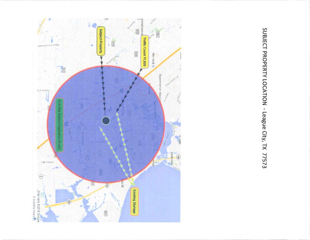
1 Zoning Change Z15-04 (Alta Vista Development) Planning & Zoning Commissionn Planning & Development Department May 4, Request Rezone approximately 8.2 acres from RSF-5 (Single-family residential with a minimumm lot size of 5,000 square feet) and OS (Open Space) to CG (General Commercial). The applicant indicates the intent to develop the property for a self-storage facility approximately 62,000 square feet in size. The site includes four (4) blocks of the Moore s Addition including three (3)) abandoned rights-of-way for Dakota, Delaware, andd Hawaii Avenues between Olive and Peach Streets. The intent of the CG (General Commercial) zoning district is for existing and future areas of larger- for scaled pedestrian- and auto-oriented commercial development located on major arterial roadways community-servinrecreation and entertainment. uses such as retail, services, office, auto-related businesses, restaurants and Applicant Owner City Council Location Citizen Response Attachments Kevin Gabriel of Alta Vista Development Ronald Booth of Opus Services Public Hearing & First Reading May 26 th, 2015; Second Reading June 9 th, 2015 Generally located north of Peach Street, south of Olive Street, east of Idaho Avenue and west of State Highway 3 with the approximate address being in the 2600 block of State Highway Notices Mailed to Property Owners within 5000 feet 0 Letters of Support Received 0 Letters of Opposition Received 1. Property Owner s Notification Map / Zoning Map 2. Aerial Map Comprehensive Plan Future Land Use Plann 4. Applicant Letter The Commission should consider the following findings in its deliberation, which shall be utilized to substantiate its findings. To determine the extent to whichh the proposed zonings would be compatible with surrounding properties, the surrounding land uses and the performance impacts should be considered. Background Site and Surrounding Area June 12, 2007 City Council approves abandonment of Dakota, Delaware and Hawaii Avenues between Olive and Peach Streets. March 23, 2015 Applicant submits application to rezone 8.2 acre property for proposed development. May 4, Planning & Zoning Commission to hear and consider recommendation to City Council. May 26, 2015 City Council scheduled to conduct public hearing and consider request on first reading. June 9, 2015 Subject to approval on first reading, City Council to consider request on second reading. The undeveloped site is covered with scrub vegetation with some trees. A Tree Disposition Plan will be required at the platting phase of the project. Z15-04 (Alta Vista Development) May 4, 2015 P&Z Meeting Page 1 of 3
2 Direction North South East West Surrounding Zoning ROW, CG and RSF-5 ROW, RSF-7, and CG ROW and RSF-7 ROW and RSF-5 Surrounding Land Use Partially developed Olive Street and undeveloped property except for one residential home Undeveloped Peach Street ROW and Undeveloped property Highway 3 and Undeveloped property Undeveloped Idaho Avenue and Undeveloped property Conformity with Comprehensivee Plan The Future Land Use Plan of the 2035 Comprehensive Plan identifies the subject property as Enhanced Auto Dominant Commercial and Rural/Estate Residential. The eastern two blocks are designed as Enhanced Auto Dominant Commercial with the remaining western two blocks designed as Rural/Estate Residential. Areas designated as Enhanced Auto Dominant Residential fully accommodates the automobile to the extent that front setbacks are typically deepp to allow forr parking with driveways and garages that are prominent, dominant part of the architecture. Areas designated as Rural/Estate Residential takes advantage of the rural look andd feel with an emphasis on large spacess for natural or agricultural purposes while building impacts are low. However, these tracts are within a transitional area between the Highway 3 commercial corridor and the residential neighborhoods in the 2 nd, 3 rd and 4 th blocks from the corridor. In addition, this area is also affected by the east/westt FM 646 corridor where multiple blocks of properties have been rezoned in recent years for developments that utilize direct access from major arterials. These corridors are a heavy dominant mixture of CG (General Commercial) and RSF-5 (Single family residential with a minimum lot size of 5,000 square feet) zoning districts with many of the interior commercially zoned blocks associated with those commercial blocks along the roadways and sporadic residential throughoutt this area. Access and Traffic Impacts Access will be provided from State Highway 3, which is under the jurisdiction of the Texas Department of Transportation (TxDOT). On June 12, 2007, City Council approved the abandonment of the Dakota, Delaware and Hawaii Avenues between Olive and Peach Streets. State Highway 3 Roadway Type ROW Width Pavement Width and Type Existing Conditions Major Arterial 150 feet 4-lane, undivided, 85-foot wide concrete pavement widthh with a 14-foot wide center turn lane and drainage ditches on eitherr side. Proposed Conditions Major Arterial As Determined by TxDOT As Determined by TxDOT Water & Sewer Equivalent Dwelling Units (EDU s) are used to determine the capacity of water and waste water available to a site. With a single-family dwelling unit being equivalent to 1 EDU, the Engineering Department indicates that the water and sewer capacity are adequate to serve this development. Water is accessible through an 8-inch water line along the west side of State Highway 3. Sanitary sewer is not accessible in the area. The applicant willl have to provide a septic sewer system upon development of the property. Z15-04 (Alta Vista Development) May 4, 2015 P&Z Meeting Page 2 of 3
3 Floodplain The easternmost block, being directly adjacent too Highway 3 is currently located within the 500 year floodplain with the remaining blocks to the west being located within the 100-year floodplain. Should the request be approved, thee applicant will be required to perform some form of mitigation either through the property orr the structure out of the 100-year floodplain at the development phase. It should be noted thatt the Federal Emergency Management Agency (FEMA) has indicated that new floodplain maps are being prepared for Galveston County and are anticipated to be finalized within the next 12 months. Preliminary floodplain maps show the entire property being located within the floodplain. It is recommended that thee development elevate the property based on the preliminary maps. The applicant has been made aware of this information. Public Benefit vs. Imposed Hardship Based upon the information provided, the Commission will have to determine the gain to publicc health, safety, welfare, due to denial of this application as compared to the hardship imposed uponn the owner as a result of denial of the application. For additional information, you may mark.linenschmidt@leaguecity.com. contact Mark Linenschmidt, Senior Planner at or at a Z15-04 (Alta Vista Development) May 4, 2015 P&Z Meeting Page 3 of 3

4 CAROLINA ALASKA HILL OREGON MULBERRY DICKINSON ELDERBERRY DELAWARE DELAWARE HAWAII SH 3 ARIZONA 500' Notification Buffer HILL MULBERRY OLIVE ARIZONA CAROLINA STRAWBERRY Subject Properties FM 646 HWY 3 HAWAII F Residential Single Family 10 Residential Single Family 5 Residential Multi-Family 2 General Commercial Office Commercial Limited Industrial Public and Semi-Public Open Space IDAHO FM 646 Zoning Map SPRUCE DELAWARE City of League City Department of Planning & Development For Planning Purposes Only 1 inch equals 449 feet


5 SSttaatte Higghwaayy 3 Paai intt & Bodyy SShop TTowingg SSttorraagge YYaa aarrd Churrcch h Olivve SStt.. Union Paacci iffi icc c RR Dicckki insson Avv vve Hilll Avve SSubj jecctt Prro operrttyy Mettaal l Reccyyccl lingg Daai irryy Dissttrr rri ibuttorr Mecc cchaani iccaal l SShop p SSttrra aawberrrryy SStt.. SSel lff SSttorraagge Caarr Deaa aal lerrsshi ip FFM 646 Beaaccon LLaakkess Golff f Courrsse Gaass SSttaatti ion Gaas ss SSttaatti ion Churrcch
6 Figure 5.1 Future Land Use Plan Impacts Dwelling Units 77,446 Population 178,875 CITY OF HOUSTON CITY OF NASSAU BAY C l e a r L a k e CLEAR LAKE SHORES G a l v e s t o n B a y Employment 54,931 Jobs to Housing Balance 0.71 Water (MGD) Sewer (MGD) FRIENDSWOOD CITY OF FRIENDSWOOD N Bay Area Blvd ") Clear Creek Palomino Ln CITY OF WEBSTER Landing Blvd Hobbs Rd ") 518 Houston Ave W Walker St Coryell St N Iowa Ave Colorado Ave Orange Grove St 2nd St Dickinson Ave «3 ")2094 Hewitt St «96 Smith Ln Austin St ") 270 Louisiana Ave ") 518 Tuscan Lakes Blvd Columbia Memorial Pkwy South Shore Blvd KEMAH «146 Land Use Acreages Rural/Estate 27.2% Suburban Residential 14.7% Suburban Village 0.7% Enhanced Auto Dominant Residential 27.0% Enhanced Auto Dominant Commercial 8.8% Suburban Commercial 0.9% Urban Low 3.0% Urban High 1.6% Public/Institutional 3.5% Parks/Open Space/Natural 12.7% Total 100.0% Maple Leaf Dr Calder Dr ") 646 Legend ") 517 Rural/Estate Residential DICKINSON Dickinson Bayou Park/Open Space/Natural ") 646 Suburban Residential Suburban Village Suburban Commercial Enhanced Auto Dominant Residential Enhanced Auto Dominant Commercial Urban High Note: A comprehensive plan shall not constitute zoning regulations or establish zoning district boundaries. Urban Low Public/Institutional 5-3
7
8
Planning. This request. incorporatedd develop the. Highway 3. similar to a. Fineas + Clover. Terri Lera of. 35 Notices. Citizen
 Zoning Change Z15-20 (Hwy 3 & Olive) Planning & Zoning Commissionn Planning & Development Department April 4, 20166 Request Rezone approximately 14.32 acres from IL (Limited Industrial) and OS (Open Space)
Planning. Zoning Change. prepared for. Staff held an. the neighborhood at the initial meeting. of Texas Avenue. approximate. 29 Notices.
 Planning & Zoning Commissionn Zoning Change Z15-11 (Power Street and Texas Avenue) Planning & Development Department June 15, 20155 Request Rezone approximately 2.0 acres from OS (Open Space) to RSF-20
Planning & Zoning Commission
 Zoning Change Z15-08 (2103 ) Planning & Zoning Commission Planning & Development Department May 18, 2015 Request Applicant /Owner Rezone approximately 2.844 acres of land from OS (Open Space) to RSF-20
Planning. 7,000 square. 25 Notices. Citizen. / Zoning Map 2. Aerial Map. Background. - A portion. Late (DRC) for application RMF-1.
 for application RMF-1.") Zoning Change Z15-13 (Cypresss Bay Commercial) Planning & Zoning Commissionn Planning & Development Department July 6, 20155 Request Rezone approximately 2.4 acres from RSF-7 (Single-family residential
Zoning Change Z15-13 (Cypresss Bay Commercial) Planning & Zoning Commissionn Planning & Development Department July 6, 20155 Request Rezone approximately 2.4 acres from RSF-7 (Single-family residential
Planning & Zoning Commission
 Planning & Zoning Commission Planning & Development Department August 14, 01 Zoning Map Amendment MAP-1-0001 (Bay View Section 4) Request Rezone approximately 1.19 acres from OS (Open Space) to RSF- (Residential
Planning. Special Use. to operate a. future. 1.5 acres. Avenue and. west of State. 31 Notices. Citizen. 0 Letter of. compatibility with.
 Planning & Zoning Commissionn Planning & Development Department December 21, 20155 Special Use Permit SUP15-09 (Vanderford Air) Request Hold a public hearing and make a recommendationn to City Council
Planning & Zoning Commission
 Zoning Change 13-03 (FM 646) Planning & Zoning Commission Planning & Development Department June 3, 2013 Request Permitted Uses Rezone approximately 24.89 acres of undeveloped land from RSF-7 (Residential
Planning & Zoning Commission Meeting Date: December 3, 2012
 Planning and Development Department City of League City Planning & Zoning Commission Meeting Date: December 3, 2012 Requests Rezone approximately 3.3 acres from RSF-5 (Single-family residential with a
Planning & Zoning Commission
 Planning & Zoning Commission Preliminary Plat Tuscan Lakes, SF 55-3 and 60-3 SE Planning & Development Department May 4, 2015 Request Applicant Owner Zoning Location Attachments Subdivide approximately
Planning. the propertyy. Texas Local. Government. Code. size of 2,0000 RSF-2-PUD. Road within the Wharf at a. Citizen. 0 Letter of. 1.
 Planning & Zoning Commissionn Replat Phase I of the Wharf at Clear Lake, Dock 18, Slips 1 and 2 Planning & Development Department February 15, 20166 Request Replat approximately 0.0209 acres of a previouslyy
Planning & Zoning Commission
 Planning & Zoning Commission Planning & Development Department March 21, 2016 Master Plan Revision Westwood Subdivision, Revision #3 Request Applicant Owner Zoning Location Attachments Background Site
Planning & Zoning Commission
 Planning & Zoning Commission Preliminary Plat Tuscan Lakes, SF 55-2 and 60-2 SE Planning & Development Department March 16, 2015 Request Applicant Owner Zoning Location Attachments Subdivide approximately
Planning. Commons. developments. Owner. Zoning. south side of. South Shore Boulevard. 2. Aerial Map. located along. South Shoree.
 Planning & Zoning Commissionn Planning & Development Department February 16, 20144 Development Plan Hidden Lakes Commons Request Applicant Owner Zoning Location Attachments Background Site and Surrounding
Planning & Zoning Commission
 Final Plat Lakes in Bay Colony, Section 7 Planning & Zoning Commission Planning & Development Department March 20, 2017 Request Applicant Owner Zoning Location Attachments Subdivide approximately 17.16
Planning. Honda) Special Use. maintenancee. service areaa. City Council Acres. Calder Road. 25 Notices. Citizen. 0 Letter of.
 Special Use. maintenancee. service areaa. City Council Acres. Calder Road. 25 Notices. Citizen. 0 Letter of.") Special Use Permit SUP14-04 (John Eagle Honda) Planning & Zoning Commissionn Planning & Development Department December 15, 20144 Request Hold a public hearing and make a recommendation to City Council
Special Use Permit SUP14-04 (John Eagle Honda) Planning & Zoning Commissionn Planning & Development Department December 15, 20144 Request Hold a public hearing and make a recommendation to City Council
Planning & Zoning Commission
 Planning & Zoning Commission Planning & Development Department March 3, 2014 Final Plat Bay View Section 2, Phase I Request Applicant Owner Zoning Location Attachments Subdivision of approximately 12.04
Planning. Preliminary. .70 acres into. tract of land. an unplatted. Edgar Barlow. 1. Proposed 2. Aerial Map. Subdivision
 Preliminary / Final Plat Glenmont, Section Two Planning & Zoning Commissionn Planning & Development Department May 19, 20144 Request Applicant Owner Zoning Location Attachments Subdivide approximately.70
Planning & Zoning Commission
 Final Plat Sedona, Section 4 Planning & Zoning Commission Planning & Development Department July 21, 2014 Request Applicant Owner Zoning Location Attachments Subdivide approximately 55.3 acres of previously
Zoning. Road within the Wharf at a. Citizen. 0 Letter of. 2. Aerial Map. Plats. Public Interest the Zoning. because the. January 7,
 Zoning Board of Adjustmentt ZBA15-11 (The Wharf Boat Dock 18, Slips 1 and 2) Planning & Development Department January 7, 20166 Requests A variance from the minimum development requirements for properties
Marion County Board of County Commissioners
 Marion County Board of County Commissioners Date: 12/29/2015 P&Z: 12/28/2015 BCC: 1/12/2016 Item Number 160113Z Type of Application Rezoning Request From: A-1 (General Agriculture) To: PUD (Planned Unit
PLANNING & DEVELOPMENT
 PLANNING & DEVELOPMENT STAFF REPORT Rezoning PETITION: APPLICANT: PROPERTY OWNER: TYPE OF REQUEST: SIZE OF TRACT: LOCATION: (#17-22) Rezone from A-PUD (Agri-Business Planned Unit Development) to A-PUD
Preliminary Plat - Westover Park, Section 11C
 Sectti ion 13A Wessttoverr Parrk,, Reccrreatti ion Cttrr Sectti ion 11C Sectti ion 11A Sectti ion 15 Sectti ion 16 Sectti ion 14A Sectti ion 14B Preliminary Plat - Westover Park, Section 11C Planning and
Town of Waxhaw Board of Commissioners. Waxhaw Police Department Community Meeting Room Tuesday January 12, 2016
 Town of Waxhaw Board of Commissioners Waxhaw Police Department Community Meeting Room Tuesday January 12, 2016 Petition RZ-003994-2015 A request by the Town of Waxhaw Planning & Community Development Department,
CITY OF DURHAM DURHAM COUNTY NORTH CAROLINA. Zoning Map Change Report. RR Existing Zoning. Rural Rural Density Residential Site Characteristics
 CITY OF DURHAM DURHAM COUNTY NORTH CAROLINA Zoning Map Change Report Meeting Date: February 26, 2007 Reference Name Arrowhead () Jurisdiction County Proposed Zoning RR Existing Zoning RS-20 Request Proposed
M E M O R A N D U M. Meeting Date: October 23, Item No. F-1. Planning and Zoning Commission. Daniel Turner, Planner I
 M E M O R A N D U M Meeting Date: October 23, 2017 Item No. F-1 To: From: Subject: Planning and Zoning Commission Daniel Turner, Planner I PUBLIC HEARING: Consider a recommendation of a of Planned Development
Planning Department Oconee County, Georgia STAFF REPORT
 Planning Department Oconee County, Georgia STAFF REPORT REZONE CASE #: 7332 DATE: November 28, 2017 STAFF REPORT BY: Gabriel Quintas, Planner APPLICANT NAME: Smith Planning Group PROPERTY OWNER: John Hadden
SUBJECT PARCEL(S) Property Owner(s) TMS Number Approximate Acreage Carolina Park Development, LLC
 Property Owner(s) TMS Number Approximate Acreage Carolina Park Development, LLC") Staff Report Special Planning Commission Meeting November 19, 2014 For reference, the Zoning Code and Land Development Regulations are available online. AGENDA ITEM 5c. SKETCH PLAN APPROVAL REQUEST: Request
Staff Report Special Planning Commission Meeting November 19, 2014 For reference, the Zoning Code and Land Development Regulations are available online. AGENDA ITEM 5c. SKETCH PLAN APPROVAL REQUEST: Request
Rezoning Report October 2018
 Zone Change Request 3099 W. Parkwood Ave. Request to change from Light Industrial (LI) to Light Industrial / Specific Use Permit (LI/SUP) to allow NAICS Use #7139 Other Amusement and Recreation Industries
Chapter 2 Land Use. State of Land Use
 Ch2 6/21/2016 1 Chapter 2 Land Use The responsibility of a municipality to manage and regulate land use is rooted in its need to protect the health, safety, and welfare of local citizens. Although only
PLANNING COMMISSION REPORT Regular Agenda Public Hearing Item
 PC Staff Report 11/12/12 Item No. 2B- 1 PLANNING COMMISSION REPORT Regular Agenda Public Hearing Item ITEM NO. 2B: A TO GPI; 110 ACRES; E OF K-10 & N OF W 6 TH ST (MKM) : Consider a request to rezone approximately
CITY OF SANTA ROSA COMMUNITY DEVELOPMENT DEPARTMENT STAFF REPORT FOR PLANNING COMMISSION SEPTEMBER 10, 2015 APPLICANT FILE NUMBER MJP
 ITEM NO. 9 CITY OF SANTA ROSA COMMUNITY DEVELOPMENT DEPARTMENT STAFF REPORT FOR PLANNING COMMISSION SEPTEMBER 10, 2015 PROJECT TITLE Yogurt Time Center ADDRESS/LOCATION 3093 Marlow Road ASSESSOR S PARCEL
Planning Department Oconee County, Georgia
 Planning Department Oconee County, Georgia STAFF REPORT REZONE CASE #: 6985 DATE: October 31, 2016 STAFF REPORT BY: Andrew C. Stern, Planner APPLICANT NAME: Williams & Associates, Land Planners PC PROPERTY
PLANNING COMMISSION REPORT Regular Agenda - Public Hearing Item
 Z-15-00469 Item No. 6A- 1 PLANNING COMMISSION REPORT Regular Agenda - Public Hearing Item PC Staff Report 11/16/15 ITEM NO. 6A GPI, RM12, & RS40 TO RM12; 14.756 ACRES; 5200 & 5300 CLINTON PKWY (SLD) Z-15-00469:
CITY OF PAPILLION PLANNING COMMISSION STAFF REPORT MAY 31, 2017 AGENDA SHADOW LAKE 2 FINAL PLAT FP
 I. GENERAL INFORMATION CITY OF PAPILLION PLANNING COMMISSION STAFF REPORT MAY 31, 2017 AGENDA SHADOW LAKE 2 FINAL PLAT FP-17-0006 A. APPLICANT: Shadow Lake 2, LLC 15950 West Dodge Road, Suite 300 Omaha,
Comprehensive Plan 2015 to 2030 STATE OF LAND USE
 Chapter 2 Land Use The responsibility of a municipality to manage and regulate land use is rooted in its need to protect the health, safety, and welfare of local citizens. Although only acting as one section
Plans shall be drawn at a readable scale, signed, and sealed by a Florida Registered Engineer. The application package shall include:
 CHAPTER 400. SECTION 403. PERMIT TYPES AND APPLICATIONS SITE DEVELOPMENT 403.3. Preliminary Site Plans (PSP) A. Intent and Purpose PSPs are used to identify existing site conditions and demonstrate general
ACTION FORM BRYAN CITY COUNCIL
 ACTION FORM BRYAN CITY COUNCIL DATE OF COUNCIL MEETING: July 8, 2014 DATE SUBMITTED: June 17, 2014 DEPARTMENT OF ORIGIN: Development Services SUBMITTED BY: Maggie Dalton MEETING TYPE: CLASSIFICATION: ORDINANCE:
Dickinson Planning & Zoning Commission Agenda Item Data Sheet
 Dickinson Planning & Zoning Commission Agenda Item Data Sheet MEETING DATE July 11, 2011 TOPIC: Conduct a public hearing for the request of a Specific Use Permit (SUP) SUP-11-0629 for a general merchandise
Bethel Romanian Church - Rezone, RZ
 / Planning and Zoning Staff Report Bethel Romanian Church - Rezone, RZ2018-0023 Hearing Date: November 15, 2018 Development Services Department Owners: Bethel Romanian Church, Corp. Applicant: Viorel Botos
DOÑA ANA COUNTY PLANNING AND ZONNING COMMISSION
 DOÑA ANA COUNTY PLANNING AND ZONNING COMMISSION Doña Ana County Government Complex 845 N. Motel Blvd. Las Cruces, New Mexico 88007 Office: (575) 647-7350 MEETING DATE: June 22, 2017 REQUEST: Variance CASE
Marion County Board of County Commissioners
 Marion County Board of County Commissioners Date: 10/27/2015 P&Z: 10/26/2015 BCC: 11/17/2015 Item Number 151104SU Type of Application Special Use Permit Request Parking of a Commercial Truck in the A-1
Marion County Board of County Commissioners
 Marion County Board of County Commissioners Date: 4/26/26 P&Z: 4/25/26 BCC: 5/17/26 Item Number 160509Z Type of Application Request to rezone the property from the Rural Commercial (RC-1) District to the
M E M O R A N D U M. Meeting Date: April 9, Item No. F-1. Planning and Zoning Commission. Scott Bradburn, Planner I
 M E M O R A N D U M Meeting Date: April 9, 2018 Item No. F-1 To: From: Subject: Planning and Zoning Commission Scott Bradburn, Planner I PUBLIC HEARING: Consider a recommendation for a Specific Use Permit
Ricker - PH / Planning and Zoning Commission Staff Report
 / Planning and Zoning Commission Staff Report Ricker - PH2018-20 Hearing Date: April 19, 2018 Development Services Department Applicant: Don Ricker Staff: Dan Lister, Planner II dlister@canyonco.org Tax
LINCOLN COUNTY PLANNING & INSPECTIONS DEPARTMENT
 LINCOLN COUNTY PLANNING & INSPECTIONS DEPARTMENT 30 NORTH ACADEMY STREET, SUITE A, LINCOLNTON, NORTH CAROLINA 809 704-736-8440 OFFICE 704-736-8434 INSPECTION REQUEST LINE 704-73-900 FAX To: Board of Commissioners
ZONING AMENDMENT & SUBDIVISION STAFF REPORT Date: March 1, 2018
 #13 SUB-000406-2018 & ZON-000407-2018 ZONING AMENDMENT & SUBDIVISION STAFF REPORT Date: March 1, 2018 NAME SUBDIVISION NAME LOCATION Creekside @ Kooiman Dairy Creekside @ Kooiman Dairy Subdivision (South
CITY OF TARPON SPRINGS Staff Report May 16, 2017
 CITY OF TARPON SPRINGS Staff Report May 16, 2017 TO: FROM: HEARING DATES: SUBJECT: MAYOR & BOARD OF COMMISSIONERS PLANNING & ZONING DEPARTMENT MAY 15, 2017 (PLANNING & ZONING BOARD) JUNE 6, 2017 (BOC 1
Marion County Board of County Commissioners
 Marion County Board of County Commissioners Date: 12/2/25 P&Z: 11/30/25 BCC: 12/16/25 Amendment No: (20)151209Z Type of Application Rezoning Request P-MH (Mobile Home Park) to B-2 (Community Business)
Diamond Falls Subdivision PROPOSED YELLOWSTONE COUNTY BOARD OF PLANNING FINDINGS OF FACT
 Diamond Falls Subdivision PROPOSED YELLOWSTONE COUNTY BOARD OF PLANNING FINDINGS OF FACT The City/County Planning Staff has prepared the Findings of Fact for the Diamond Falls Subdivision. These findings
Planning Commission Application Summary
 Planning Commission Application Summary Project Name: Creekside Estates Zone Change and Land Use Amendment Address: 571 West 11400 South Current Zoning: RA1 Hearing Date: July 14, 2016 Summary of Request
PLANNING AND ZONING COMMISSION VARIANCE
 PLANNING AND ZONING COMMISSION VARIANCE DOÑA ANA COUNTY COMMUNITY DEVELOPMENT DEPARTMENT Doña Ana County Government Center 845 N. Motel Blvd. Las Cruces, New Mexico 88007 Telephone: (575) 647-7350 MEETING
DEPARTMENT OF COMMUNITY DEVELOPMENT SERVICES. Planning Division. m e m o r a n d u m
 DEPARTMENT OF COMMUNITY DEVELOPMENT SERVICES Planning Division m e m o r a n d u m TO: FROM: The Urbana Zoning Board of Appeals Christopher Marx, AICP, Planner I DATE: December 15, 2017 SUBJECT: ZBA Case
Cherokee Webster Development, LP. City of Webster, Texas Planned Development No. 3. Proposed Revision No. 4
 Cherokee Webster Development, LP. City of Webster, Texas Planned Development No. 3 Proposed Revision No. 4 October 2013 1 Statement of Intent This Revision No. 4 of the Statement of Intent is written in
TOWN OF ORO VALLEY PLANNING & ZONING COMMISSION MEETING DATE: December 6, 2011
 PLANNING & ZONING COMMISSION MEETING DATE: December 6, 2011 TO: FROM: SUBJECT: PLANNING & ZONING COMMISSION Matt Michels, Senior Planner mmichels@orovalleyaz.gov; tel. 229-4822 Public Hearing: Rancho de
Action Recommendation: Budget Impact:
 City of Fayetteville Staff Review Form 2017-0451 Legistar File ID 9/5/2017 City Council Meeting Date - Agenda Item Only N/A for Non-Agenda Item Andrew Garner Submitted By 8/18/2017 Submitted Date Action
Action Recommendation: Budget Impact:
 City of Fayetteville Staff Review Form 2018-0744 Legistar File ID 1/3/2019 City Council Meeting Date - Agenda Item Only N/A for Non-Agenda Item Garner Stoll 12/14/2018 CITY PLANNING (630) Submitted By
PLANNING COMMISSION REPORT Regular Agenda Public Hearing Item
 PC Staff Report 6/20/16 Item No. 4-1 PLANNING COMMISSION REPORT Regular Agenda Public Hearing Item PC Staff Report 06/20/16 ITEM NO. 4: IG to CS 1.56 ACRES; 706 E 23 RD STREET (MKM) : Consider a request
PLANNING AND ZONING COMMISSION ZONE CHANGE
 PLANNING AND ZONING COMMISSION ZONE CHANGE DOÑA ANA COUNTY COMMUNITY DEVELOPMENT DEPARTMENT Doña Ana County Government Center 845 N. Motel Blvd. Las Cruces, New Mexico 88007 Telephone: (575) 647-7350 MEETING
Request Subdivision Variance (Section 4.4(c)(1) of the Subdivision Regulations) Staff Recommendation Approval. Staff Planner Jonathan Sanders
(1) of the Subdivision Regulations) Staff Recommendation Approval. Staff Planner Jonathan Sanders") Applicant & Owner Public Hearing February 14, 2018 City Council Election District Bayside Agenda Item 4 Request Subdivision Variance (Section 4.4(c)(1) of the Subdivision Regulations) Staff Recommendation
Applicant & Owner Public Hearing February 14, 2018 City Council Election District Bayside Agenda Item 4 Request Subdivision Variance (Section 4.4(c)(1) of the Subdivision Regulations) Staff Recommendation
PLANNING AND ZONING COMMISSION VARIANCE
 PLANNING AND ZONING COMMISSION VARIANCE DOÑA ANA COUNTY COMMUNITY DEVELOPMENT DEPARTMENT Doña Ana County Government Center 845 N. Motel Blvd. Las Cruces, New Mexico 88007 Telephone: (575) 647-7350 MEETING
Staff Report: Date: Applicant: Property Identification: Acreage of Request: Current Zoning of Requested Area: Requested Action: Attached:
 Staff Report: Completed by Jeff Palmer Director of Planning & Zoning Date: November 7, 2018, Updated November 20, 2018 Applicant: Greg Smith, Oberer Land Developer agent for Ronald Montgomery ET AL Property
Town of Cary, North Carolina Rezoning Staff Report 14-REZ-31 Cary Park PDD Amendment (Waterford II) Town Council Meeting January 15, 2015
 Town Council Meeting January 15, 2015") Town of Cary, North Carolina Rezoning Staff Report 14-REZ-31 Cary Park PDD Amendment (Waterford II) Town Council Meeting January 15, 2015 REQUEST To amend the Town of Cary Official Zoning Map by amending
Town of Cary, North Carolina Rezoning Staff Report 14-REZ-31 Cary Park PDD Amendment (Waterford II) Town Council Meeting January 15, 2015 REQUEST To amend the Town of Cary Official Zoning Map by amending
Planning. Special Use. by removingg. Subdivision, will be sold pond for the Ordinances entitled Zoning acres. approximate , 2016.
 Planning & Zoning Commissionn Planning & Development Department August 29, 20166 Special Use Permit SUP16-02 (Duncan Sand Pit) Request Applicant Owner Acreage Location City Council Citizen Response Attachments
Tuss and Lisa Taylor. Agriculture
 ZONE CHANGE STAFF REPORT CCPC City-County Planning Commission warrenpc.org (270) 842-1953 1141 State Street Bowling Green, KY 42101 DOCKET/CASE/APPLICATION NUMBER 2018-29-Z-CO PUBLIC HEARING DATE July
RIVERTON CITY PLANNING COMMISSION MEETING AGENDA. May 12, 2016
 RIVERTON CITY PLANNING COMMISSION MEETING AGENDA May 12, 2016 Notice is hereby given that the Riverton City Planning Commission will hold a meeting beginning at 6:30 p.m. on May 12, 2016 at Riverton City
RECOMMENDATION Following the public hearing, consider Zoning Case PD14-16, with a Development Plan.
 Staff Report Zoning Case PD14-16 (Helzer Tract) Planning and Zoning Meeting Date: 12-17-14 Document Being Considered: Ordinance RECOMMENDATION Following the public hearing, consider Zoning Case PD14-16,
ARTICLE IV: DEVELOPMENT STANDARDS
 ARTICLE IV: DEVELOPMENT STANDARDS IV-53 409 PRIVATE STREETS A private street means any way that provides ingress to, or egress from, property by means of vehicles or other means, or that provides travel
/ Planning and Zoning Commission Staff Report Jay Walker- All Terra Consulting - RZ
 / Planning and Zoning Commission Staff Report Jay Walker- All Terra Consulting - Hearing Date: January 17, 2019 Development Services Department Applicant: Jay Walker All Terra Consulting Staff: Jennifer
Urban Planning and Land Use
 Urban Planning and Land Use 701 North 7 th Street, Room 423 Phone: (913) 573-5750 Kansas City, Kansas 66101 Fax: (913) 573-5796 Email: planninginfo@wycokck.org www.wycokck.org/planning To: From: City Planning
SUBDIVISION, PLANNED UNIT DEVELOPMENT, PLANNING APPROVAL, ZONING AMENDMENT, & SIDEWALK WAIVER REQUEST STAFF REPORT Date: February 17, 2010
 SUBDIVISION, PLANNED UNIT DEVELOPMENT, PLANNING APPROVAL, ZONING AMENDMENT, & SIDEWALK WAIVER REQUEST STAFF REPORT Date: February 17, 2010 APPLICANT NAME SUBDIVISION NAME DEVELOPMENT NAME LOCATION David
Lincoln County Board of Commissioner s Agenda Item Cover Sheet
 Lincoln County Board of Commissioner s Agenda Item Cover Sheet Board Meeting Date: Agenda Item Type: Consent Agenda: Public Hearing: Regular Agenda: Presentation Time (est): Submitting Person: Phone Number/Ext:
Marion County Board of County Commissioners
 Marion County Board of County Commissioners Date: 6/28/2017 P&Z: 6/26/2017 BCC: 7/18/2017 Item Number 170701Z Type of Application Rezoning Request B-2, Community Business to R-1, Single Family Residential
Quail Point - City of League City, Galveston County, Texas
 Contact: Kirk Laguarta/ KLaguarta@landadvisors.com Office 713.647.7800/ Fax 713.647.7830 10497 Town & Country Way, Suite 820 Houston, Texas 77024 www.landadvisors.com Quail Point - City of League City,
DOÑA ANA COUNTY PLANNING AND ZONNING COMMISSION
 DOÑA ANA COUNTY PLANNING AND ZONNING COMMISSION Doña Ana County Government Complex 845 N. Motel Blvd. Las Cruces, New Mexico 88007 Office: (575) 647-7350 MEETING DATE: February 23, 2017 REQUEST: Zone Change
COUNCIL ACTION FORM. 1. The City Council can approve the Preliminary Plat for Menards Ames Subdivision
 ITEM #: 49 DATE: 03-27-18 COUNCIL ACTION FORM SUBJECT: PRELIMINARY PLAT FOR MENARDS BACKGROUND: Menards Ames Subdivision is a proposed 41-acre development on SE 16 th Street just west of the Skunk River.
REZONING APPLICATION INSTRUCTIONS
 REZONING APPLICATION INSTRUCTIONS All required information, as stated on the Rezoning Application Checklist, must be included to qualify as a complete application. Upon receipt, staff will review the application
DAUPHIN CREEK ESTATES SUBDIVISION
 # 12 SUB-000076-2017 DAUPHIN CREEK ESTATES SUBDIVISION Engineering Comments: FINAL PLAT COMMENTS (should be addressed prior to submitting the FINAL PLAT for review and/or signature by the City Engineer):
Cover Letter with Narrative Statement
 Cover Letter with Narrative Statement March 31, 2017 rev July 27, 2017 RE: Rushton Pointe Residential Planned Unit Development Application for Public Hearing for RPUD Rezone PL2015 000 0306 Mr. Eric Johnson,
PROJECT NH 0050(99)381 PCN 6926 YANKTON COUNTY. SD HWY 50 (4 th Street) from Broadway Ave to Archery Road in Yankton, SD
381 PCN 6926 YANKTON COUNTY. SD HWY 50 (4 th Street) from Broadway Ave to Archery Road in Yankton, SD") Public Meeting/ Open House April 4, 2013 PROJECT NH 0050(99)381 PCN 6926 YANKTON COUNTY SD HWY 50 (4 th Street) from Broadway Ave to Archery Road in Yankton, SD Grading, PCC Pavement, Asphalt Concrete
Public Meeting/ Open House April 4, 2013 PROJECT NH 0050(99)381 PCN 6926 YANKTON COUNTY SD HWY 50 (4 th Street) from Broadway Ave to Archery Road in Yankton, SD Grading, PCC Pavement, Asphalt Concrete
LOCATION MAP: AERIAL PHOTOGRAPH, 2015:
 LOCATION MAP: AERIAL PHOTOGRAPH, 2015: ORDINANCE NO. AN ORDINANCE OF THE CITY OF BRYAN, TEXAS, AMENDING CHAPTER 130, ZONING, OF THE CITY OF BRYAN CODE OF ORDINANCES, BY CHANGING THE ZONING CLASSIFICATION
A. Location. A MRD District may be permitted throughout the County provided it meets the standards established herein.
 752. Multi-Residential District (MRD) The Multi-Residential (MRD) District is intended to provide opportunities for rural, suburban and urban density mixed-residential developments consistent with the
M E M O R A N D U M. Planning and Zoning Commission. Daniel Turner, Planner I
 M E M O R A N D U M Meeting Date: Monday, April 10, 2017 Item No. F-4 To: From: Planning and Zoning Commission Daniel Turner, Planner I Subject: Consider a recommendation of a Preliminary Site Evaluation
PLANNING COMMISSION REPORT
 PLANNING COMMISSION REPORT MEETING DATE: 04/05/2018 FROM: PRESENTED BY: Diana Figueroa, Management Assistant Jeremy Underwood, Planner SUBJECT GPA17-09 and ZON17-14 El Prado: A request by Susan Demmitt
RULES, REGULATIONS AND REQUIREMENTS RELATING TO THE APPROVAL AND ACCEPTANCE OF IMPROVEMENTS IN SUBDIVISIONS OR RE-SUBDIVISIONS
 GALVESTON COUNTY RULES, REGULATIONS AND REQUIREMENTS RELATING TO THE APPROVAL AND ACCEPTANCE OF IMPROVEMENTS IN SUBDIVISIONS OR RE-SUBDIVISIONS GALVESTON COUNTY ENGINEERING DEPARTMENT MARCH 3, 1997 Amendment
DESOTO COUNTY PLANNING AND ZONING DEPARTMENT STAFF REPORT
 DESOTO COUNTY PLANNING AND ZONING DEPARTMENT STAFF REPORT REQUEST: PROPERTY OWNER: APPLICANT: AGENT: SE 2014-02 Felix & Maria Zapata Felix & Maria Zapata Same N/A PROPERTY: 35-38-24-0116-0010-0090 TOTAL
LARAMIE COUNTY PLANNING & DEVELOPMENT DEPARTMENT
 LARAMIE COUNTY PLANNING & DEVELOPMENT DEPARTMENT Planning Building MEMORANDUM TO: FROM: Laramie County Planning Commission Bryan Nicholas, Associate Planner DATE: February 14, 2019 TITLE: Review and action
ZONING VARIANCES ADMINISTRATIVE
 200 W. Oak Street, 3rd Floor Fort Collins, CO 80521 (970) 498-7683 / larimer.org/planning ZONING VARIANCES ADMINISTRATIVE The submittal requirements listed in this packet are intended to collect all of
Marion County Board of County Commissioners
 Marion County Board of County Commissioners Date: 12/2/2015 P&Z: 11/30/2015 BCC: 12/16/2015 Item Number 151210SU Type of Application Special Use Permit Request To establish a Clay Electric Co-Operative
6 February 13, 2013 Public Hearing APPLICANT/ PROPERTY OWNER: FRANK T. WILLIAMS
 6 February 13, 2013 Public Hearing APPLICANT/ PROPERTY OWNER: FRANK T. WILLIAMS STAFF PLANNER: Ray Odom REQUEST: Subdivision Variance to Section 4.4(b) of the Subdivision Ordinance that requires all newly
Department of Planning & Development Services
 Department of Planning & Development Services S T A F F R E P O R T May 13, 2016 CASE NO: PROJECT: EXECUTIVE SUMMARY: DETAILS: ZA16-029 Zoning Change and Development Plan for the Carillon Corporate District
Marion County Planning & Zoning Commission
 Marion County Planning & Zoning Commission Date: /3/24 P&Z: 9/29/24 BCC: /21/24 Item Number 1409Z Type of Application Rezoning Request From: R-3, Multiple Family Residential To: B-4, Regional Business
PLANNING AND ZONING COMMISSION
 PLANNING AND ZONING COMMISSION DOÑA ANA COUNTY COMMUNITY DEVELOPMENT DEPARTMENT Doña Ana County Government Center 845 N. Motel Blvd. Las Cruces, New Mexico 88007 Telephone: (575) 647-7350 MEETING DATE:
APPLICANT NAME SUBDIVISION NAME DEVELOPMENT NAME LOCATION. CITY COUNCIL DISTRICT Council District 4 PRESENT ZONING PROPOSED ZONING
 SUBDIVISION, PLANNED UNIT DEVELOPMENT, PLANNING APPROVAL, ZONING AMENDMENT, & SIDEWALK WAIVER REQUEST STAFF REPORT Date: February 17, 2010 APPLICANT NAME SUBDIVISION NAME DEVELOPMENT NAME LOCATION David
Request Rezoning (B-2 Community Business to R-20 Residential) Staff Recommendation Approval. Staff Planner Marchelle Coleman
 Staff Recommendation Approval. Staff Planner Marchelle Coleman") Applicant & Property Owner Public Hearing October 11, 2017 City Council Election District Kempsville Agenda Item 4 Request Rezoning (B-2 Community Business to R-20 Residential) Staff Recommendation Approval
Applicant & Property Owner Public Hearing October 11, 2017 City Council Election District Kempsville Agenda Item 4 Request Rezoning (B-2 Community Business to R-20 Residential) Staff Recommendation Approval
ZONING AMENDMENT, PLANNED UNIT DEVELOPMENT & SUBDIVISION STAFF REPORT Date: August 8, 2013
 ZONING AMENDMENT, PLANNED UNIT DEVELOPMENT & SUBDIVISION STAFF REPORT Date: August 8, 2013 NAME SUBDIVISION NAME PV-Magnolia, LLC Twelve Trees Subdivision LOCATION 2860, 2862 and 2866 Pleasant Valley Road
Marion County Board of County Commissioners
 Marion County Board of County Commissioners Date: 10/29/25 P&Z: 10/26/25 BCC: 11/17/25 Item Number 151106SU Type of Application Special Use Permit Request Special Use Permit Modification to: 1. Add a secondary
Section Preliminary Plat Checklist and Application Forms
 Section 201 - Preliminary Plat Checklist and Application Forms PRELIMINARY SUBDIVISION PLAT REVIEW PROCESS CHART PRELIMINARY SUBDIVISION PLAT APPLICATION PRELIMINARY PLAT REVIEW CHECKLIST CITY OF NAMPA
PC Staff Report 11/18/2013 Z Item No. 1-1
 Z-13-00401 Item No. 1-1 PLANNING COMMISSION REPORT Regular Agenda - Public Hearing Item PC Staff Report 11/18/2013 ITEM NO. 1: Z-13-00401 IG (General Industrial) District TO CS (Strip Commercial) District;
ZONING AMENDMENT, PLANNED UNIT DEVELOPMENT & SUBDIVISION STAFF REPORT Date: September 15, 2011
 ZONING AMENDMENT, PLANNED UNIT DEVELOPMENT & SUBDIVISION STAFF REPORT Date: September 15, 2011 NAME SUBDIVISION NAME LOCATION Stratford, L.L.C. Grelot Office Park Subdivision North side of Grelot Road,
1 November 13, 2013 Public Hearing APPLICANT & PROPERTY OWNER: HOME ASSOCIATES OF VIRGINIA, INC.
 1 November 13, 2013 Public Hearing APPLICANT & PROPERTY OWNER: HOME ASSOCIATES OF VIRGINIA, INC. STAFF PLANNER: Carolyn A.K. Smith REQUEST: Conditional Change of Zoning (AG-1 & AG-2 Agricultural Districts