ZONING AMENDMENT & SUBDIVISION STAFF REPORT Date: July 3, 2014
|
|
|
- Lucinda King
- 5 years ago
- Views:
Transcription
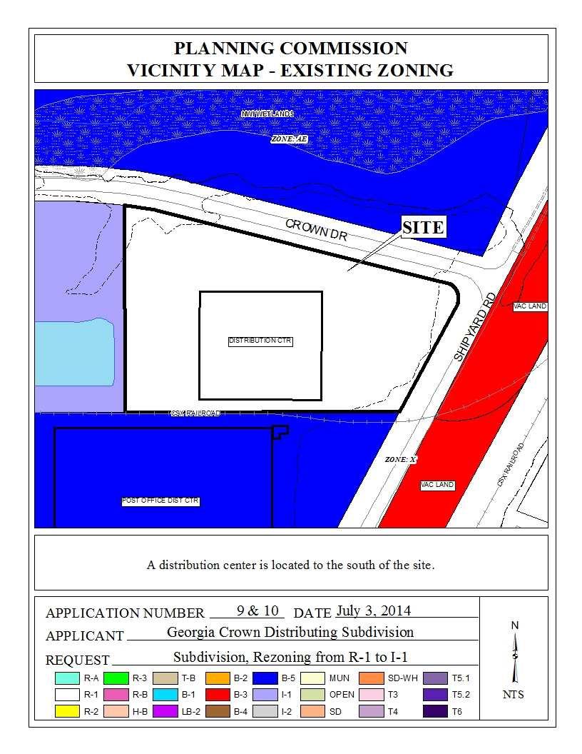
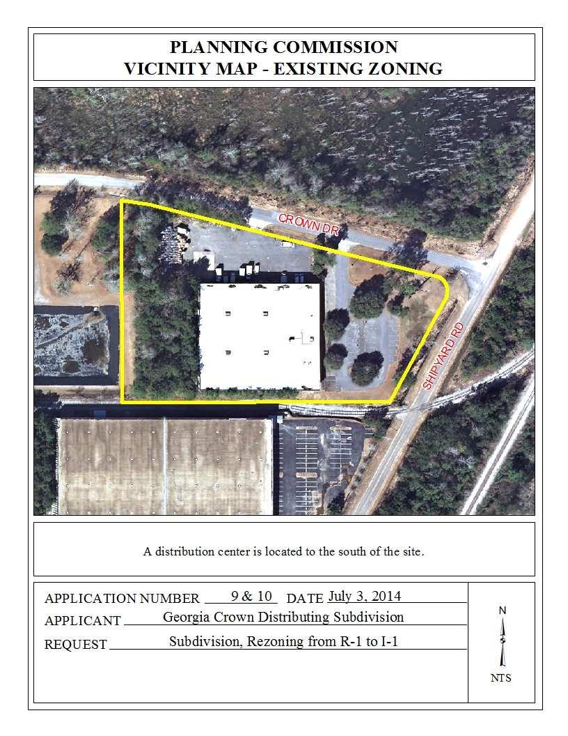
1 ZONING AMENDMENT & SUBDIVISION STAFF REPORT Date: July 3, 2014 APPLICANT NAME SUBDIVISION NAME LOCATION Georgia Crown Distributing Subdivision Georgia Crown Distributing Subdivision Southwest corner of Shipyard Road and Crown Drive. CITY COUNCIL DISTRICT District 4 PRESENT ZONING PROPOSED ZONING AREA OF PROPERTY R-1, Single-Family Residential District I-1, Light Industry District 1 Lot/ 3.9 ± Acres CONTEMPLATED USE Subdivision to create 1 legal lot of record from a metes and bounds parcel, and Zoning to rezone the site from R-1, Single-Family Residential District to I-1, Light Industry District, to accommodate an existing business. It should be noted, however, that any use permitted in the proposed district would be allowed at this location if the zoning is changed. Furthermore, the Planning Commission may consider zoning classifications other than that sought by the applicant for this property. REASON FOR REZONING Applicant is requesting rezoning of the site to accommodate an existing business. TIME SCHEDULE FOR DEVELOPMENT None given. ENGINEERING COMMENTS Subdivision: The following comments should be addressed prior to submitting the FINAL PLAT for acceptance and signature by the City Engineer: A. Provide all of the required information on the SUBDIVISION PLAT (i.e. signature blocks, signatures, certification statements, written legal description, required notes, legend, scale, bearings and distances) that is required by the current Alabama State Board of Licensure for Professional Engineers and Land Surveyors. B. Add a note to the SUBDIVISION PLAT stating that a Land Disturbance permit will be required for any land disturbing activity in accordance with the of the Storm Water Management and Flood Control Ordinance (Mobile City Code, Chapter 17, Ordinance #
2 007 & #65-045), latest edition. Storm water detention may be required for any future addition(s) and/or land disturbing activity. C. Add a note to the SUBDIVISION PLAT stating that as shown on the 1984 aerial photo (FLIGHT 23 - #90) the Lot will receive historical credit of impervious area towards storm water detention requirement per the Storm Water Management and Flood Control Ordinance (Mobile City Code, Chapter 17, Ordinance # & #65-045), latest edition. Coordinate with City Engineering Department staff to establish the exact amount prior to the submittal of the Land Disturbance Permit application. D. Add a note to the Plat stating that the approval of all applicable federal, state, and local agencies (including all storm water runoff, wetland and floodplain requirements) will be required prior to the issuance of a Land Disturbance permit. E. Provide a vicinity map. F. Revision of the plat to label each lot with its size in acres and square feet, or the furnishing of a table on the Plat providing the same information. G. Provide a written legal description for the proposed subdivision and matching bearing and distance labels. H. Show and label all flood zones. I. Show and label the MFFE (Minimum Finished Floor Elevation) on each lot that contains an AE, V, or X (shaded) flood zone designation. J. Provide and label the monument set or found at each subdivision corner. K. Add a signature block for the Owner, Notary Public, Planning Commission, Traffic Engineer, and City Engineer. L. Provide the Surveyor s Certificate and Signature. M. Provide the Owner s (notarized), Planning Commission, and Traffic Engineering signatures. Add a note that sidewalk is required to be constructed along the frontage of each lot, or parcel, at time of development, unless a sidewalk waiver is approved. TRAFFIC ENGINEERING COMMENTS Site is denied access to Shipyard Road, and limited to the two existing curb cuts on Crown Drive, with size, location and design to be approved by Traffic Engineering and conform to AASHTO standards. URBAN FORESTRY COMMENTS Property to be developed in compliance with state and local laws that pertain to tree preservation and protection on both city and private properties (State Act and City Code Chapters 57 and 64). FIRE DEPARTMENT COMMENTS All projects within the City of Mobile Fire Jurisdiction must comply with the requirements of the 2009 International Fire Code, as adopted by the City of Mobile. REMARKS The applicant is requesting Subdivision approval to create one legal lot of record from an existing metes and bounds parcel, and Zoning approval to rezone the site from R-1, Single-Family Residential District to I-1, Light Industry District to accommodate an existing business
3 The site is already developed with an existing warehouse that was previously used as a regional distribution center for Georgia Crown Distributing. The site was developed and utilized as commercial property prior to it s annexation into the City limits where it is currently zoned R-1, Single Family Residential. As it is today, the site can continue to operate as a warehouse/ distribution center; however, if there were any changes in use, any new construction, or to become vacant for longer than 2 consecutive years, any non-conforming status would be lost. The owner(s) would like to sell the property as a commercial lot, but in order to do so, they must go through the Rezoning and Subdivision process. The site is bounded to the West by an I-1, Light Industry District, to the North and South by a B- 5, Office-Distribution District, and to the East by a B-3, Community Business District. It should also be pointed out that behind the B-3 strip of undeveloped commercial property is an R-1, Single Family Residential District. Subdivision review examines the site with regard to promoting orderly development, protecting general health, safety and welfare, and ensuring that development is correlated with adjacent developments and public utilities and services, and to ensure that the subdivision meets the minimum standards set forth in the Subdivision Regulations for lot size, road frontage, lot configuration, etc. As stated in Section of the Zoning Ordinance, the intent of the Ordinance and corresponding Zoning Map is to carry out the comprehensive planning objective of sound, stable and desirable development. While changes to the Ordinance are anticipated as the city grows, the established public policy is to amend the ordinance only when one or more of the following conditions prevail: 1) there is a manifest error in the Ordinance; 2) changing conditions in a particular area make a change in the Ordinance necessary and desirable; 3) there is a need to increase the number of sites available to business or industry; or 4) the subdivision of land into building sites makes reclassification of the land necessary and desirable. The site is shown as residential on the Land Use Component of the Comprehensive Plan, which is meant to serve as a general guide, not a detailed lot and district plan or mandate for development. The accuracy of recommended land uses on the General Land Use Component map is limited due to the large scale of the map. Moreover, the General Land Use Component allows the Planning Commission and City Council to consider individual cases based on additional information such as the classification request, the surrounding development, the timing of the request, and the appropriateness and compatibility of the proposed use and zoning classification. The applicant states the following justification for rezoning: The site contains a 45,000 sf building, which was constructed about 31 years ago. It has been used for the last 7 years or so by Georgia Crown Distributing for a regional distribution center. The site has ample parking and truck loading/ staging area. We plan no changes to the building or site because the property is now for sale. The site was annexed into the City about 21 years ago as R-1. We are in the Cypress Business Park surrounded by B-3, B-5, and I-1 zoning. Georgia Crown has used the building as B-5-3 -
4 operations for handling, warehousing and distribution. To maximize the potential of the site, we would like to request I-1 zoning to match our neighbor to the west. The Zoning Ordinance discusses I-1 as suitable for light manufacturing of wholesaling where the use and its operations do not directly adversely affect nearby residential and business uses. These districts are usually separate from residential areas by business areas or by natural barriers. Across Crown Drive is B-5 zoning, wetlands and an AE zone creek. Across Shipyard Drive is a wooden strip of unbuildable B-3 zoning and CSX railroad tracks. We believe rezoning from R-1 to I-1 is warranted due to a manifest error in the ordinance. Most of the adjacent sites have been rezoned from R-1, Single Family Residential, to B-5, Office- Distribution District or I-1, Light Industry District. The applicant(s) state that they are requesting an I-1, Light Industry Zoning District to maximize the potential of the site. However, the applicant has not proposed a more intense use that requires more than a B-5 Zoning Classification, thus a B-5, Office-Distribution zoning would suffice for the existing development. The applicant(s) also mentioned they would like the property rezoned to an I-1, Light Industry District to match the neighbor to the West of the site. However, the adjacent neighbors along Shipyard Road are zoned B-5, Office-Distribution District; therefore either zoning classification would be in line with the surrounding area. The site has frontage on Shipyard Road and Crown Drive, two minor streets without curb and gutter. Both streets appear to have compliant right-of-ways, thus no additional dedication will be required. The site has two existing curb-cuts to Crown Drive. If approved, a note should be placed on the Final Plat limiting the site to two curb-cuts to Crown Drive with any changes to the size, design, and location to be approved by Traffic Engineering and conform to AASHTO standards. The lot size is not labeled in square feet and acres. If approved, revisions should be made to depict the lot size in square feet and acres on the Final Plat, or a table should be furnished on the Final Plat providing the same information. The 25-foot minimum building setback line is not depicted on the preliminary plat. If approved, revisions should be made on the Final Plat to illustrate the 25 minimum building setback line. A sidewalk is not depicted on the zoning site plan. Prior to any new development of the site, the applicant should submit a sidewalk waiver or provide a sidewalk at time of any new construction as required by the Subdivision Regulations. It should be noted the site currently does not meet the tree and landscaping requirements of the Zoning Ordinance. If approved, the applicant should coordinate with Planning and Urban Forestry for the provision of adequate frontage trees. Two portions of the site appear to be located within the X-shaded flood zone. The presence of floodplains indicate that the area may be environmentally sensitive; therefore, the approval of all applicable federal, state and local agencies would be required prior to the issuance of any permits or land disturbance activities
5 Finally, the geographic area defined by the city of Mobile and its planning jurisdiction, including this site, may contain Federally-listed threatened or endangered species as well as protected nongame species. Development of the site must be undertaken in compliance with all local, state and Federal regulations regarding endangered, threatened or otherwise protected species. RECOMMENDATION Subdivision: The Subdivision request is recommended for Tentative Approval, subject to the following conditions: 1) retention of the right-of-way width of Shipyard Road and Crown Drive on the Final Plat; 2) illustration of the 25 minimum building setback line along Shipyard Road and Crown Drive on Final Plat; 3) the labeling of the lot with its size in square feet and acres, or the furnishing of a table on the Final Plat providing the same information; 4) prior to any new construction on the site, the applicant should submit a sidewalk waiver or provide a sidewalk at time of new construction as required by the Subdivision Regulations; 5) placement of a note on the Final Plat stating that the lot is limited to two curb-cuts to Crown Drive with any changes to the size, design, and location to be approved by Traffic Engineering and ALDOT, and conform to AASHTO standards; 6) placement of a note on the Final Plat stating that approval of all applicable Federal, state and local agencies is required for endangered, threatened or otherwise protected species, if any, prior to the issuance of any permits or land disturbance activities; 7) placement of a note on the Final Plat stating that approval of all applicable Federal, state and local agencies is required for flood zone issues prior to the issuance of any permits or land disturbance activities; 8) compliance with Engineering comments: The following comments should be addressed prior to submitting the FINAL PLAT for acceptance and signature by the City Engineer: A. Provide all of the required information on the SUBDIVISION PLAT (i.e. signature blocks, signatures, certification statements, written legal description, required notes, legend, scale, bearings and distances) that is required by the current Alabama State Board of Licensure for Professional Engineers and Land Surveyors. B. Add a note to the SUBDIVISION PLAT stating that a Land Disturbance permit will be required for any land disturbing activity in accordance with the of the Storm Water Management and Flood Control Ordinance (Mobile City Code, Chapter 17, Ordinance # & #65-045), latest edition. Storm water detention may be required for any future addition(s) and/or land disturbing activity. C. Add a note to the SUBDIVISION PLAT stating that as shown on the 1984 aerial photo (FLIGHT 23 - #90) the Lot will receive historical credit of impervious area towards storm water detention requirement per the Storm Water Management and Flood Control Ordinance (Mobile City Code, Chapter 17, Ordinance # & #65-045), latest edition. Coordinate with City Engineering Department staff to establish the exact amount prior to the submittal of the Land Disturbance Permit application. D. Add a note to the Plat stating that the approval of all applicable federal, state, and local agencies (including all storm water runoff, wetland and floodplain requirements) will be required prior to the issuance of a Land Disturbance permit. E. Provide a vicinity map. F. Revision of the plat to label each lot with its size in acres and - 5 -
6 square feet, or the furnishing of a table on the Plat providing the same information. G. Provide a written legal description for the proposed subdivision and matching bearing and distance labels. H. Show and label all flood zones. I. Show and label the MFFE (Minimum Finished Floor Elevation) on each lot that contains an AE, V, or X (shaded) flood zone designation. J. Provide and label the monument set or found at each subdivision corner. K. Add a signature block for the Owner, Notary Public, Planning Commission, Traffic Engineer, and City Engineer. L. Provide the Surveyor s Certificate and Signature. M. Provide the Owner s (notarized), Planning Commission, and Traffic Engineering signatures. N. Add a note that sidewalk is required to be constructed along the frontage of each lot, or parcel, at time of development, unless a sidewalk waiver is approved. ; 9) compliance with Traffic Engineering comments: Site is denied access to Shipyard Road, and limited to the two existing curb cuts on Crown Drive, with size, location and design to be approved by Traffic Engineering and conform to AASHTO standards. ; 10) compliance with Urban Forestry comments: Property to be developed in compliance with state and local laws that pertain to tree preservation and protection on both city and private properties (State Act and City Code Chapters 57 and 64). ; and 11) compliance with Fire comments: All projects within the City of Mobile Fire Jurisdiction must comply with the requirements of the 2009 International Fire Code, as adopted by the City of Mobile. Rezoning: Based upon the preceding, the request is recommended for approval as a B-5, Office- Distribution District, subject to the following conditions: 1) provision of adequate frontage trees to be coordinated with Planning and Urban Forestry; 2) completion of the Subdivision process; and 3) full compliance with all municipal codes and ordinances
7 - 7 -
8 - 8 -
9 - 9 -
10 - 10 -
ZONING AMENDMENT, PLANNED UNIT DEVELOPMENT & SUBDIVISION STAFF REPORT Date: August 8, 2013
 ZONING AMENDMENT, PLANNED UNIT DEVELOPMENT & SUBDIVISION STAFF REPORT Date: August 8, 2013 NAME SUBDIVISION NAME PV-Magnolia, LLC Twelve Trees Subdivision LOCATION 2860, 2862 and 2866 Pleasant Valley Road
ZONING AMENDMENT & SUBDIVISION STAFF REPORT Date: July 9, 2015
 ZONING AMENDMENT & SUBDIVISION STAFF REPORT Date: July 9, 2015 APPLICANT NAME 2513 Dauphin Street, Inc. SUBDIVISION NAME Audubon Place Extension No. 3, Resubdivision of Lots 1-5 LOCATION 2513 Dauphin Street
ZONING AMENDMENT & SUBDIVISION STAFF REPORT Date: March 7, 2013
 # 4 & 5 SUB2012-00141 & ZON2012-03157 HOLDOVER ZONING AMENDMENT & SUBDIVISION STAFF REPORT Date: March 7, 2013 APPLICANT NAME SUBDIVISION NAME LOCATION Garrard Development Services, LLC Michigan & Bay
PLANNED UNIT DEVELOPMENT & SUBDIVISION STAFF REPORT Date: September 15, 2016
 # 10 SUB2016-00089 PLANNED UNIT DEVELOPMENT & SUBDIVISION STAFF REPORT Date: September 15, 2016 NAME SUBDIVISION NAME LOCATION Lot 12 Laughlin Industrial Park Subdivision Lot 12 Laughlin Industrial Park
ZONING AMENDMENT & SUBDIVISION STAFF REPORT Date: June 18, 2015
 ZONING AMENDMENT & SUBDIVISION STAFF REPORT Date: June 18, 2015 APPLICANT NAME SUBDIVISION NAME EAA LLC / Eryka Rogers Aaiden Place Subdivision LOCATION 2480 Government Boulevard (North side of Government
MOBILE TOWERS SUBDIVISION
 # 3 SUB2014-00100 MOBILE TOWERS SUBDIVISION Engineering Comments: The following comments should be addressed prior to submitting the FINAL PLAT for acceptance and signature by the City Engineer: 1) Provide
SUBDIVISION, PLANNED UNIT DEVELOPMENT, PLANNING APPROVAL, ZONING AMENDMENT, & SIDEWALK WAIVER REQUEST STAFF REPORT Date: February 17, 2010
 SUBDIVISION, PLANNED UNIT DEVELOPMENT, PLANNING APPROVAL, ZONING AMENDMENT, & SIDEWALK WAIVER REQUEST STAFF REPORT Date: February 17, 2010 APPLICANT NAME SUBDIVISION NAME DEVELOPMENT NAME LOCATION David
SUBDIVISION, PLANNING APPROVAL, & REZONING STAFF REPORT Date: June 4, 2015
 SUBDIVISION, PLANNING APPROVAL, & REZONING STAFF REPORT Date: June 4, 2015 APPLICANT NAME SUBDIVISION NAME DEVELOPMENT NAME LOCATION Board of Water & Sewer Commissioners of the City of Mobile MAWSS MLK
APPLICANT NAME SUBDIVISION NAME DEVELOPMENT NAME LOCATION. CITY COUNCIL DISTRICT Council District 4 PRESENT ZONING PROPOSED ZONING
 SUBDIVISION, PLANNED UNIT DEVELOPMENT, PLANNING APPROVAL, ZONING AMENDMENT, & SIDEWALK WAIVER REQUEST STAFF REPORT Date: February 17, 2010 APPLICANT NAME SUBDIVISION NAME DEVELOPMENT NAME LOCATION David
TULSA PARK ESTATES SUBDIVISION, RESUBDIVISION OF LOT 6
 TULSA PARK ESTATES SUBDIVISION, RESUBDIVISION OF LOT 6 Engineering Comments: FINAL PLAT COMMENTS (should be addressed prior to submitting the FINAL PLAT for review and/or signature by the City Engineer):
JOHNNY S RV PARK SUBDIVISION
 # 11 SUB2016-00001 JOHNNY S RV PARK SUBDIVISION Engineering Comments: The following comments should be addressed prior to submitting the FINAL PLAT for acceptance and signature by the City Engineer: A.
DAUPHIN CREEK ESTATES SUBDIVISION
 # 12 SUB-000076-2017 DAUPHIN CREEK ESTATES SUBDIVISION Engineering Comments: FINAL PLAT COMMENTS (should be addressed prior to submitting the FINAL PLAT for review and/or signature by the City Engineer):
ZONING AMENDMENT, PLANNED UNIT DEVELOPMENT & SUBDIVISION STAFF REPORT Date: March 5, 2009
 ZONING AMENDMENT, PLANNED UNIT DEVELOPMENT & SUBDIVISION STAFF REPORT Date: March 5, 2009 NAME SUBDIVISION NAME LOCATION Kentress Morrisette Booker T. Washington Highlands Subdivision, First Addition,
ZONING AMENDMENT, & SUBDIVISION STAFF REPORT Date: July 24, 2008
 ZONING AMENDMENT, & SUBDIVISION STAFF REPORT Date: July 24, 2008 APPLICANT NAME SUBDIVISION NAME Remax Realty Professionals Star Motel Subdivision LOCATION 2005 and 2009 Douglas Lane (Southwest corner
ALBA BEACH SUBDIVISION, RESUBDIVISION OF LOT 17
 ALBA BEACH SUBDIVISION, RESUBDIVISION OF LOT 17 Engineering Comments: FINAL PLAT COMMENTS (should be addressed prior to submitting the FINAL PLAT for acceptance and signature by the City Engineer): A.
ZONING AMENDMENT & SUBDIVISION STAFF REPORT Date: March 1, 2018
 #13 SUB-000406-2018 & ZON-000407-2018 ZONING AMENDMENT & SUBDIVISION STAFF REPORT Date: March 1, 2018 NAME SUBDIVISION NAME LOCATION Creekside @ Kooiman Dairy Creekside @ Kooiman Dairy Subdivision (South
ZONING AMENDMENT, & SUBDIVISION STAFF REPORT Date: May 17, 2007
 ZONING AMENDMENT, & SUBDIVISION STAFF REPORT Date: May 17, 2007 APPLICANT NAME SUBDIVISION NAME LOCATION Christopher J. Nix, Agent Mobile Central Subdivision 2570, 2590, & 2598 Government Boulevard (Northeast
PLANNED UNIT DEVELOPMENT, SIDEWALK WAIVER, & SUBDIVISION STAFF REPORT Date: November 6, 2008
 PLANNED UNIT DEVELOPMENT, SIDEWALK WAIVER, & SUBDIVISION STAFF REPORT Date: November 6, 2008 DEVELOPMENT NAME SUBDIVISION NAME LOCATION Frascati Shops, Inc. Frascati Subdivision 1120 Paper Mill Road CITY
DINKINS ESTATE FAMILY SUBDIVISION
 # 9 SUB2015-00122 DINKINS ESTATE FAMILY SUBDIVISION Engineering Comments: The following comments should be addressed prior to submitting the FINAL PLAT for acceptance and signature by the City Engineer:
ZONING AMENDMENT & SUBDIVISION STAFF REPORT Date: November 3, 2016
 ZONING AMENDMENT & SUBDIVISION STAFF REPORT Date: November 3, 2016 APPLICANT NAME SUBDIVISION NAME David Shumer 5955 Airport Subdivision CITY COUNCIL DISTRICT District 6 5955 Airport Boulevard, 754 Linlen
MTC ALABAMA SUBDIVISION
 # 2 SUB-000370-2017 MTC ALABAMA SUBDIVISION Engineering Comments: FINAL PLAT COMMENTS (should be addressed prior to submitting the FINAL PLAT for review and/or signature by the City Engineer): A. Provide
THE WHEELER BUILDING SUBDIVISION
 THE WHEELER BUILDING SUBDIVISION Engineering Comments: FINAL PLAT COMMENTS (should be addressed prior to submitting the FINAL PLAT for review and/or signature by the City Engineer): A. Provide all of the
BROADWAY THREE NOTCH ROAD SUBDIVISION
 # 3 SUB-000803-2018 BROADWAY THREE NOTCH ROAD SUBDIVISION Engineering Comments: FINAL PLAT COMMENTS (should be addressed prior to submitting the FINAL PLAT for review and/or signature by the City Engineer):
WESTMINSTER PARK SUBDIVISION
 WESTMINSTER PARK SUBDIVISION Engineering Comments: FINAL PLAT COMMENTS (should be addressed prior to submitting the FINAL PLAT for review and/or signature by the City Engineer): A. Provide all of the required
WESTMINSTER PARK PLACE SUBDIVISION
 WESTMINSTER PARK PLACE SUBDIVISION Engineering Comments: FINAL PLAT COMMENTS (should be addressed prior to submitting the FINAL PLAT for review and/or signature by the City Engineer): A. Provide all of
PLANNED UNIT DEVELOPMENT & SUBDIVISION STAFF REPORT August 18, 2016
 PLANNED UNIT DEVELOPMENT & SUBDIVISION STAFF REPORT August 18, 2016 DEVELOPMENT NAME SUBDIVISION NAME Mullinax Ford Subdivision Mullinax Ford Subdivision LOCATION CITY COUNCIL DISTRICT District 6 Southeast
SUBDIVISION, PLANNED UNIT DEVELOPMENT, ZONING AMENDMENT, & SIDEWALK WAIVER STAFF REPORT Date: July 19, 2018
 SUBDIVISION, PLANNED UNIT DEVELOPMENT, ZONING AMENDMENT, & SIDEWALK WAIVER STAFF REPORT Date: July 19, 2018 NAME SUBDIVISION NAME LOCATION West Mobile Properties, LLC U.S. Machine Subdivision 556, 566,
PLANNED UNIT DEVELOPMENT & SUBDIVISION STAFF REPORT Date: April 18, 2019
 PLANNED UNIT DEVELOPMENT & SUBDIVISION STAFF REPORT Date: April 18, 2019 DEVELOPMENT NAME SUBDIVISION NAME Springhill Village Subdivision Springhill Village Subdivision LOCATION 4350, 4354, 4356, 4358,
AMENDMENT TO REGULATING PLAN & SUBDIVISION STAFF REPORT Date: December 15, 2016
 AMENDMENT TO REGULATING PLAN & SUBDIVISION STAFF REPORT Date: December 15, 2016 NAME SUBDIVISION NAME Gulf States Engineering- Mathew C. Roberts, PLS Precision Engineering Subdivision LOCATION CITY COUNCIL
KLUGE PLACE SUBDIVISION
 KLUGE PLACE SUBDIVISION Engineering Comments: Must comply with the Mobile County Flood Damage Prevention Ordinance. Development shall be designed to comply with the storm water detention and drainage facility
ZONING AMENDMENT, SUBDIVISION & SIDEWALK WAIVER REQUEST STAFF REPORT Date: November 16, 2006
 ZONING AMENDMENT, SUBDIVISION & SIDEWALK WAIVER REQUEST STAFF REPORT Date: November 16, 2006 NAME SUBDIVISION NAME Terhaar & Cronley Investment Partnership P & E Subdivision LOCATION 4210 and 4218 Halls
HERON LANDING SUBDIVISION
 HERON LANDING SUBDIVISION Engineering Comments: Per FEMA guidelines, any development greater than 5 acres in size or subdivision 50 lots in size, requires a flood study. Width of drainage easement to be
ZONING AMENDMENT, PLANNED UNIT DEVELOPMENT & PLANNING APPROVAL STAFF REPORT Date: June 7, 2007
 ZONING AMENDMENT, PLANNED UNIT DEVELOPMENT & PLANNING APPROVAL STAFF REPORT Date: June 7, 2007 NAME LOCATION Johnny Randall Cotton and Angela K. Cotton 4800 Tufts Road (West side of Tufts Road, 50 ± North
COCHRAN FAMILY RIVERSIDE ESTATE SUBDIVISION
 # 19 SUB2012-00111 COCHRAN FAMILY RIVERSIDE ESTATE SUBDIVISION Engineering Comments: The following comments should be addressed prior to review, acceptance and signature by the City Engineer: 1. Label/show
PLANNED UNIT DEVELOPMENT & SUBDIVISION STAFF REPORT Date: July 20, 2017
 PLANNED UNIT DEVELOPMENT & SUBDIVISION STAFF REPORT Date: July 20, 2017 DEVELOPMENT NAME SUBDIVISION NAME LOCATION Rangeline Crossing III Subdivision Rangeline Crossing III Subdivision 5289 Halls Mill
ZONING AMENDMENT & PLANNED UNIT DEVELOPMENT STAFF REPORT Date: June 7, 2012
 ZONING AMENDMENT & PLANNED UNIT DEVELOPMENT STAFF REPORT Date: June 7, 2012 NAME DEVELOPMENT NAME LOCATION Mayo Blackmon Mayo Blackmon 1446 Navco Road & 2452 McLaughlin Drive. (North side of McLaughlin
SUBDIVISION & PLANNING APPROVAL STAFF REPORT Date: December 1, 2016
 SUBDIVISION & PLANNING APPROVAL STAFF REPORT Date: December 1, 2016 APPLICANT NAME SUBDIVISION NAME DEVELOPMENT NAME LOCATION Board of Water and Sewer Commissioners of the City of Mobile Halls Mill Road
ZONING AMENDMENT, PLANNED UNIT DEVELOPMENT & SUBDIVISION STAFF REPORT Date: September 15, 2011
 ZONING AMENDMENT, PLANNED UNIT DEVELOPMENT & SUBDIVISION STAFF REPORT Date: September 15, 2011 NAME SUBDIVISION NAME LOCATION Stratford, L.L.C. Grelot Office Park Subdivision North side of Grelot Road,
DEER RIVER COMMERCIAL PARK SUBDIVISION
 DEER RIVER COMMERCIAL PARK SUBDIVISION Engineering Comments: Must comply with the Mobile County Flood Damage Prevention Ordinance. Development shall be designed to comply with the storm water detention
ZONING AMENDMENT & PLANNED UNIT DEVELOPMENT STAFF REPORT Date: July 5, 2012
 ZONING AMENDMENT & PLANNED UNIT DEVELOPMENT STAFF REPORT Date: July 5, 2012 NAME DEVELOPMENT NAME LOCATION Mayo Blackmon Mayo Blackmon 1446 Navco Road & 2452 McLaughlin Drive. (North side of McLaughlin
PLANNED UNIT DEVELOPMENT & ZONING AMENDMENT STAFF REPORT Date: December 21, 2017
 # 14 PUD-000324-2017 & ZON-000326-2017 PLANNED UNIT DEVELOPMENT & ZONING AMENDMENT STAFF REPORT Date: December 21, 2017 APPLICANT NAME DEVELOPMENT NAME LOCATION Dewberry/Preble-Rish Longleaf Gates Subdivision,
THE BLUFFS AT CYPRESS CREEK SUBDIVISION, PHASE ONE
 THE BLUFFS AT CYPRESS CREEK SUBDIVISION, PHASE ONE Engineering Comments: Shipyard Road shall be constructed to City Standard up through proposed Cypress Park Drive. Show Minimum FFE on plans and plat.
HAWTHORNE PLACE SUBDIVISON, RESUBDIVISION OF LOT 15 REVISED
 # 10 SUB-000336-2017 HAWTHORNE PLACE SUBDIVISON, RESUBDIVISION OF LOT 15 REVISED Engineering Comments: FINAL PLAT COMMENTS (should be addressed prior to submitting the FINAL PLAT for review and/or signature
KRONER S MOBILE WEST COMMERCIAL BUSINESS PARK SUBDIVISION
 KRONER S MOBILE WEST COMMERCIAL BUSINESS PARK SUBDIVISION Engineering Comments: Must comply with the Mobile County Flood Damage Prevention Ordinance. Development shall be designed to comply with the storm
SOUTHERN INDUSTRIAL PARK SUBDIVISION, LOT A, RESUBDIVISION OF LOTS 7 & 8
 SOUTHERN INDUSTRIAL PARK SUBDIVISION, LOT A, RESUBDIVISION OF LOTS 7 & 8 Engineering Comments: Need to increase width of existing easement to include an area at least 20 from the top of the existing ditch,
McGowin Park, LLC. B-3, Community Business District
 # 10, 11, 12 SUB2014-00024 ZON2014-00500 ZON2014-00501 SUBDIVISION, PLANNED UNIT DEVELOPMENT (East), PLANNED UNIT DEVELOPMENT (West) STAFF REPORT Date: April 3, 2014 DEVELOPMENT NAME LOCATION McGowin Park,
ZONING AMENDMENT STAFF REPORT Date: September 15, 2016
 ZONING AMENDMENT STAFF REPORT Date: September 15, 2016 NAME LOCATION Clear Water, LLC 3490 Hurricane Bay Road (Northeast corner of Hurricane Bay Road and Hurricane Bay Lane) CITY COUNCIL DISTRICT District
BETTA STOR-IT SUBDIVISION
 BETTA STOR-IT SUBDIVISION Engineering Comments: Must comply with all storm water and flood control ordinances. Any increase in impervious area in excess of 4,000 square feet will require detention. Any
AMELIA LAKE SUBDIVISON, PHASES 1-2
 # 1 HOLDOVER Revised SUB2014-00089 AMELIA LAKE SUBDIVISON, PHASES 1-2 Engineering Comments: Must comply with the Mobile County Flood Damage Prevention Ordinance. Development shall be designed to comply
THE CITY OF MOBILE, ALABAMA
 THE CITY OF MOBILE, ALABAMA LETTER OF DECISION March 9, 2018 Byrd Surveying, Inc. 2609 Halls Mill Road Mobile, AL 36606 Re: 4439 Rangeline Road (Northwest corner of Rangeline Road and Halls Mill Road).
# 14 SUB CANAL SUBDIVISION
 CANAL SUBDIVISION Engineering Comments: Label each Lot showing the required minimum finished floor elevation (MFFE). It appears that Lots 2, 3 & 4 are located in the AE Flood Zone; add a note to the plat
SUBDIVISION, PLANNED UNIT DEVELOPMENT, & REZONING STAFF REPORT Date: September 17, 2015
 SUBDIVISION, PLANNED UNIT DEVELOPMENT, & REZONING STAFF REPORT Date: September 17, 2015 APPLICANT NAME SUBDIVISION NAME DEVELOPMENT NAME LOCATION Daniel Clark Mack Manufacturing Subdivision, Resubdivision
PLANNED UNIT DEVELOPMENT & SUBDIVISION STAFF REPORT Date: November 17, 2016
 PLANNED UNIT DEVELOPMENT & SUBDIVISION STAFF REPORT Date: November 17, 2016 DEVELOPMENT NAME SUBDIVISION NAME LOCATION Autonation Ford of Mobile Autonation Ford of Mobile Subdivision 901, 909, and 925
NOBLE DRIVE EAST SUBDIVISION
 NOBLE DRIVE EAST SUBDIVISION Engineering Comments: Must comply with the Mobile County Flood Damage Prevention Ordinance. Development shall be designed to comply with the storm water detention and drainage
AUTUMNDALE SUBDIVISION, RESUBDIVISION OF LOTS
 AUTUMNDALE SUBDIVISION, RESUBDIVISION OF LOTS 100-102 Engineering Comments: Road shall be constructed per City standards and according to the City s street acceptance process. Cul-de sac approval subject
THE CITY OF MOBILE, ALABAMA MOBILE Crry PLANNING COMMISSION
 THE CITY OF MOBILE, ALABAMA MOBILE Crry PLANNING COMMISSION LETTER OF DECISION MLK Avenue Redevelopment Corp. Attn: Michael Pierce P.O. Box 2204 Mobile, AL 36652 Re: Case #SUB2014-00040 (Subdivision) MLK
PROVISION POINTE SUBDIVISION
 PROVISION POINTE SUBDIVISION Engineering Comments: Must comply with the Mobile County Flood Damage Prevention Ordinance. Development shall be designed to comply with the storm water detention and drainage
# 1 HOLDOVER Revised SUB CANAL SUBDIVISION
 CANAL SUBDIVISION Engineering Comments: Label each Lot showing the required minimum finished floor elevation (MFFE). It appears that Lots 2, 3 & 4 are located in the AE Flood Zone; add a note to the plat
THE CITY OF MOBILE, ALABAMA
 THE CITY OF MOBILE, ALABAMA LETTER OF DECISION Dewberry I Preble-Rish 9949 Bellaton Avenue Daphne, AL 36526 Re: 6050 & 6086 Whitebark Drive (North side of Girby Road, 125'± East of Bristlecone Drive, extending
TURTLE CREEK SUBDIVISION, PHASE THREE
 TURTLE CREEK SUBDIVISION, PHASE THREE Engineering Comments: Must comply with the Mobile County Flood Damage Prevention Ordinance. Development shall be designed to comply with the storm water detention
DAWES SWITCHING STATION SUBDIVISION
 DAWES SWITCHING STATION SUBDIVISION Engineering Comments: Must comply with the Mobile County Flood Damage Prevention Ordinance. Development shall be designed to comply with the storm water detention and
THE CI FY OF MOBILE, ALABAMA
 THE CI FY OF MOBILE, ALABAMA LETTER OF DECISION DewberryiPreble-Rish 9949 Bellaton Avenue Daphne, AL 36526 Re: Area bounded by Foxtail Drive, Lace Bark Drive and Whitebark Drive Council District 6 SUB-000323-2017
PLANNED UNIT DEVELOPMENT & SUBDIVISION STAFF REPORT Date: March 15, 2007
 PLANNED UNIT DEVELOPMENT & SUBDIVISION STAFF REPORT Date: March 15, 2007 DEVELOPMENT NAME SUBDIVISION NAME LOCATION Motormax Subdivision Motormax Subdivision 2917 and 2929 Government Boulevard (South side
MCGOWIN PARK EAST OF SATCHEL PAIGE SUBDIVISION, RESUBDIVISION OF
 # 14 SUB2015-00058 MCGOWIN PARK EAST OF SATCHEL PAIGE SUBDIVISION, RESUBDIVISION OF Engineering Comments: The following comments should be addressed prior to submitting the FINAL PLAT for acceptance and
THE CITY OF MOBILE, ALABAMA
 THE CITY OF MOBILE, ALABAMA LETTER OF DECISION Dominion Senior Living of West Mobile, LLC 1200 Corporate Dr., St. 225 Birmingham, AL 35242 Re: 6924 Somerbv Lane (North terminus of Somerby Lane). Council
SUBDIVISION, PLANNED UNIT DEVELOPMENT, & REZONING STAFF REPORT Date: March 23, 2017
 SUBDIVISION, PLANNED UNIT DEVELOPMENT, & REZONING STAFF REPORT Date: March 23, 2017 APPLICANT NAME SUBDIVISION NAME DEVELOPMENT NAME LOCATION Sarah & Michael Stashak Old Shell at Ashland Place Subdivision
SUBDIVISION, PLANNED UNIT DEVELOPMENT, & PLANNING APPROVAL STAFF REPORT Date: February 1, 2007
 SUBDIVISION, PLANNED UNIT DEVELOPMENT, & PLANNING APPROVAL STAFF REPORT Date: February 1, 2007 DEVELOPMENT NAME SUBDIVISION NAME Pala Verde Mobile Home Park Subdivision Pala Verde Mobile Home Park Subdivision
MAGNOLIA SPRINGS SUBDIVISION, PHASE ONE
 MAGNOLIA SPRINGS SUBDIVISION, PHASE ONE Engineering Comments: Must comply with the Mobile County Flood Damage Prevention Ordinance. Development shall be designed to comply with the storm water detention
THE CITY OF MOBILE, ALABAMA
 THE CITY OF MOBILE, ALABAMA LE 'I IER OF DECISION Kimberly Clark Mobile Operations 200 Africatown Blvd. Prichard, AL 36610 Re: 100 & 200 Africatown Boulevard (Northeast corner of Bay Bridge Road and Paper
PLANNED UNIT DEVELOPMENT STAFF REPORT Date: October 19, 2017
 PLANNED UNIT DEVELOPMENT STAFF REPORT Date: October 19, 2017 DEVELOPMENT NAME LOCATION Custom Boat Storage 3975 Demetropolis Road (East side of Demetropolis Road, 0.2± miles South of Halls Mill Road.)
TERRY POIROUX FAMILY DIVISION SUBDIVISION
 TERRY POIROUX FAMILY DIVISION SUBDIVISION Engineering Comments: Must comply with the Mobile County Flood Damage Prevention Ordinance. Development shall be designed to comply with the storm water detention
MOBILE CITY PLANNING COMMISSION LETTER OF DECISION. August 19, 2011
 Case #SUB2011-00082 (Subdivision) Subdivision (West side of Demetropolis Road, 1900 + South of Cottage Hill Road). Number of Lots / Acres: 1 Lot / 12.5± Acres Engineer / Surveyor: Driven Engineering, Inc.
BAY FOREST PARK SUBDIVISION, RESUBDIVISION OF LOTS 6 & 7 AND BAY FOREST PARK SUBDIVISION LOT 10, OF THE RESUBDIVISON OF LOTS 9 & 10
 BAY FOREST PARK SUBDIVISION, RESUBDIVISION OF LOTS 6 & 7 AND BAY FOREST PARK SUBDIVISION LOT 10, OF THE RESUBDIVISON OF LOTS 9 & 10 Engineering Comments: Must comply with the Mobile County Flood Damage
STONE HEDGE SUBDIVISION, UNIT 1, RESUBDIVISION OF LOT 40 & WEST COMMON AREA
 # 5 SUB-000498-2018 STONE HEDGE SUBDIVISION, UNIT 1, RESUBDIVISION OF LOT 40 & WEST COMMON AREA Engineering Comments: Must comply with the Mobile County Flood Damage Prevention Ordinance. Development shall
PENNY LAKES SUBDIVISION
 PENNY LAKES SUBDIVISION Engineering Comments: A portion of the site may be located within the J.B. Converse watershed, the primary drinking water supply for the Mobile Area Water and Sewer System. Consultation
PORT CITY COMMERCE PARK SUBDIVISION
 # 4 SUB2015-00019 PORT CITY COMMERCE PARK SUBDIVISION Engineering Comments: Must comply with the Mobile County Flood Damage Prevention Ordinance. Development shall be designed to comply with the storm
PLANNED UNIT DEVELOPMENT (East), PLANNED UNIT DEVELOPMENT (West) STAFF REPORT Date: September 18, 2014
, PLANNED UNIT DEVELOPMENT (West) STAFF REPORT Date: September 18, 2014") PLANNED UNIT DEVELOPMENT (East), PLANNED UNIT DEVELOPMENT (West) STAFF REPORT Date: September 18, 2014 DEVELOPMENT NAME LOCATION McGowin Park, LLC PLANNED UNIT DEVELOPMENT (East) 1401 Satchel Paige Drive
PLANNED UNIT DEVELOPMENT (East), PLANNED UNIT DEVELOPMENT (West) STAFF REPORT Date: September 18, 2014 DEVELOPMENT NAME LOCATION McGowin Park, LLC PLANNED UNIT DEVELOPMENT (East) 1401 Satchel Paige Drive
PLANNED UNIT DEVELOPMENT & SUBDIVISION STAFF REPORT Date: May 6, 2004
 # 3. & 4. File # ZON2004-00967 & SUB2004-00085 PLANNED UNIT DEVELOPMENT & SUBDIVISION STAFF REPORT Date: May 6, 2004 DEVELOPMENT NAME SUBDIVISION NAME Heron Lakes Subdivision, Phase One, Revised Lot 32
PLANNED UNIT DEVELOPMENT STAFF REPORT Date: August 20, 2015
 # 3 HOLDOVER Revised ZON2015-01733 PLANNED UNIT DEVELOPMENT STAFF REPORT Date: August 20, 2015 DEVELOPMENT NAME LOCATION Joseph N. Asarisi, P.E. North side of Airport Boulevard 212 ± West of Mckeena Court.
MOBILE CITY PLANNING COMMISSION LETTER OF DECISION. June 3, 2011
 MOBILE CITY PLANNING COMMISSION LETTER OF DECISION P.O. Box 421 Mobile, AL 36601 Re: Case #SUB2011-00029 (Subdivision) Alabama West Subdivision, Unit Four 2600 McVay Drive North (North side of McVay Drive
Planning Department Oconee County, Georgia
 Planning Department Oconee County, Georgia STAFF REPORT REZONE CASE #: 6985 DATE: October 31, 2016 STAFF REPORT BY: Andrew C. Stern, Planner APPLICANT NAME: Williams & Associates, Land Planners PC PROPERTY
DAWES OAK SUBDIVISION
 DAWES OAK SUBDIVISION Engineering Comments: Must comply with the Mobile County Flood Damage Prevention Ordinance. The plat illustrates the proposed 82-lot, 28.1± acre subdivision, which is located on the
PALMER WOODS SUBDIVISION, PHASE III
 PALMER WOODS SUBDIVISION, PHASE III Engineering Comments: Must comply with the Mobile County Flood Damage Prevention Ordinance. MAWSS Comments: MAWSS has NO water and sewer services available. The plat
# 6 Case #SUB LEGACY SUBDIVISION. Engineering Comments: Must comply with the Mobile County Flood Damage Prevention Ordinance.
 LEGACY SUBDIVISION Engineering Comments: Must comply with the Mobile County Flood Damage Prevention Ordinance. The plat illustrates the proposed 46 lot, 26.7 + acres subdivision which is located on the
MINOR SUBDIVISION FINAL PLAT APPLICATION Town of Apex, North Carolina
 MINOR SUBDIVISION FINAL PLAT APPLICATION Town of Apex, North Carolina This document is a public record under the North Carolina Public Records Act and may be published on the Town s website or disclosed
MASTER SUBDIVISION FINAL PLAT APPLICATION Town of Apex, North Carolina
 MASTER SUBDIVISION FINAL PLAT APPLICATION Town of Apex, North Carolina This document is a public record under the North Carolina Public Records Act and may be published to the Town s website or disclosed
THE BLUFFS AT CYPRESS CREEK SUBDIVISION
 THE BLUFFS AT CYPRESS CREEK SUBDIVISION Engineering Comments: Must comply with all stormwater and flood control ordinances. Any work performed in the right-of-way will require a right-of-way permit. Traffic
Application for Conditional Use Permit CITY OF VALDOSTA PLANNING AND ZONING DIVISION
 Application for Conditional Use Permit CITY OF VALDOSTA PLANNING AND ZONING DIVISION This is an application for approval of a Conditional Use as listed in the Table of Uses of the Valdosta Land Development
FINAL SITE PLAN PLAT APPLICATION Town of Apex, North Carolina
 FINAL SITE PLAN PLAT APPLICATION Town of Apex, North Carolina This document is a public record under the North Carolina Public Records Act and may be published on the Town s website or disclosed to third
ELIZA JORDAN CORNER SUBDIVISION
 ELIZA JORDAN CORNER SUBDIVISION Engineering Comments: Must comply with the Mobile County Flood Damage Prevention Ordinance. Development shall be designed to comply with the storm water detention and drainage
Medical Marijuana Special Exception Use Information
 Medical Marijuana Special Exception Use Information The Special Exception Use information below is a modified version of the Unified Development Code. It clarifies the current section 5:104 Special Exceptions
Applications will be received on business days between 9:00 AM and 3:00 PM
 Special Use Permit Application Douglas County Board of Commissioners Douglas County, Georgia Applications will be received on business days between 9:00 AM and 3:00 PM Date of Application: Application
SILVER PINES SUBDIVISION
 SILVER PINES SUBDIVISION Engineering Comments: Must comply with the Mobile County Flood Damage Prevention Ordinance. The plat illustrates the proposed 39.4+ acre, 153 lot subdivision, which is located
LAND USE APPLICATION
 LAND USE APPLICATION File Name: File No(s).: Receipt No.: Receipt Date: Received By: Amount.: $ Instructions for Applicants Please read and follow all instructions on your application carefully. If you
JEFFERSON COUNTY, ALABAMA
 JEFFERSON COUNTY, ALABAMA Major Development Checklist, Notes and Information A Major Development is any proposed new structure or addition to an existing structure which will cause a change in the topography
Planning Department Oconee County, Georgia STAFF REPORT
 Planning Department Oconee County, Georgia STAFF REPORT REZONE CASE #: 7332 DATE: November 28, 2017 STAFF REPORT BY: Gabriel Quintas, Planner APPLICANT NAME: Smith Planning Group PROPERTY OWNER: John Hadden
O-I (Office-Institutional) and AG-1(Agricultural)
 and AG-1(Agricultural)") PROPERTY INFORMATION ADDRESS 3503 and 3505 Bethany Bend DISTRICT, LAND LOTS 2/1 973 and 974 OVERLAY DISTRICT State Route 9 PETITION NUMBERS EXISTING ZONING O-I (Office-Institutional) and AG-1(Agricultural)
PROPERTY INFORMATION ADDRESS 3503 and 3505 Bethany Bend DISTRICT, LAND LOTS 2/1 973 and 974 OVERLAY DISTRICT State Route 9 PETITION NUMBERS EXISTING ZONING O-I (Office-Institutional) and AG-1(Agricultural)
OAK HILL SUBDIVISION
 OAK HILL SUBDIVISION Engineering Comments: Must comply with the Mobile County Flood Damage Prevention Ordinance. MAWSS Comments: MAWSS has no water or sewer services available. The plat illustrates the
APPLICATION REVIEW CHECKLISTS
 APPLICATION REVIEW CHECKLISTS The following must be submitted with and are part of each application. No application is complete until all required documentation has been submitted to the Community Development
REZONING APPLICATION INSTRUCTIONS
 REZONING APPLICATION INSTRUCTIONS All required information, as stated on the Rezoning Application Checklist, must be included to qualify as a complete application. Upon receipt, staff will review the application