Role of National CLR Systems in the ELF-Cadastre Project. Amalia Velasco Martín-Varés Dirección General del Catastro. Spain
|
|
|
- Randall Daniel
- 6 years ago
- Views:
Transcription
1 Bratislava 2016 Role of National CLR Systems in the ELF-Cadastre Project Amalia Velasco Martín-Varés Dirección General del Catastro. Spain
2 Bratislava 2016 Role of National CLR Systems in the ELF-Cadastre Project 1- Introduction.Why? 2- What ELF is 3- ELF Cadastral Index Map 4- Other ELF services 5- ELF applications 6- Access to ELF products 7- Future 8- Conclusions
3 There are growing demands and expectations for highly detailed, authoritative, harmonised, cross-border geospatial information for evidence-based decisions; both from Institutions (CEE - UNGGIM) Citizens and companies


4 We must offer the information to the European society to promote added value initiatives that encourage the development We need facilitate the access to information of real estate to make possible the exchange of real estates between people of different countries. We should promote our information as support to the European politics that act on the territory, environmental, fiscal, safety and emergencies, etc


5 Society needs authoritative, high resolution dataset Bratislava 2016 The United Nations Committee of Experts on Global Geospatial Information Management Decision 5/103, There is an urgent need for a set of global fundamental geospatial data themes that could be harmonized in order to enable the measurement, monitoring and management of sustainable development in a consistent way over time and to facilitate evidence-based decision-making and policymaking.

6 Actualidad Bratislava 2016 To do it connection between statistical and geographical information is essential To conduct high-quality (demographic, economic, environmental, health, etc.) surveys, To do monitoring and spatial analysis as well as to represent and disseminate statistical data


7 Core Data Bratislava 2016 UN wants integrate information from the National Statistical Institutes and Eurostat with geographic information of the IGN and cadastral organizations of each country, and combine it with other information in the territory. Geospatial data more required by the use cases Source:


8 There are another policies that oblige us to provide our data Bratislava 2016 public data such as geographical,...should be made available for innovative products

9 Also growing exchange of real estates between people of different countries. They need information foreigners buy one of each 5 flats that are sold
10

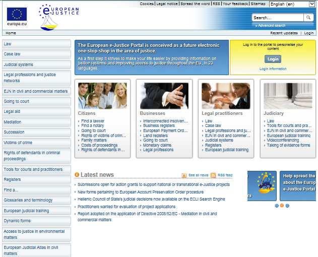
11 European E- justice Portal Bratislava 2016


12 Society has discovery of geographic information; There are new challenges many of them related to cadastre: Economic and social globalization


13 Smart Cities development needs also authoritative reference data Bratislava 2016

14 It is necessary also cadastral data that can be combinated with other data For this reason it is important: Colaboration, Standars and mainly clear accesibility conditions


15 Is Cadastral data necessary? Bratislava 2016


16 The Land Monitoring Service Essential geospatial data sets Land monitoring Service Ortho-imagery Buildings Administrative units Hydrographic network Land cover/use Transport networks Digital elevation models Preferably delivered via web services 16

17 The Emergency Management Service Essential geospatial data sets Emergency Management Service Ortho-imagery Assets at risk Building footprints and blocks Built-up areas Hydrographic network Land cover/use Transport networks Digital elevation models Bratislava 2016 Preferably delivered via web services 17


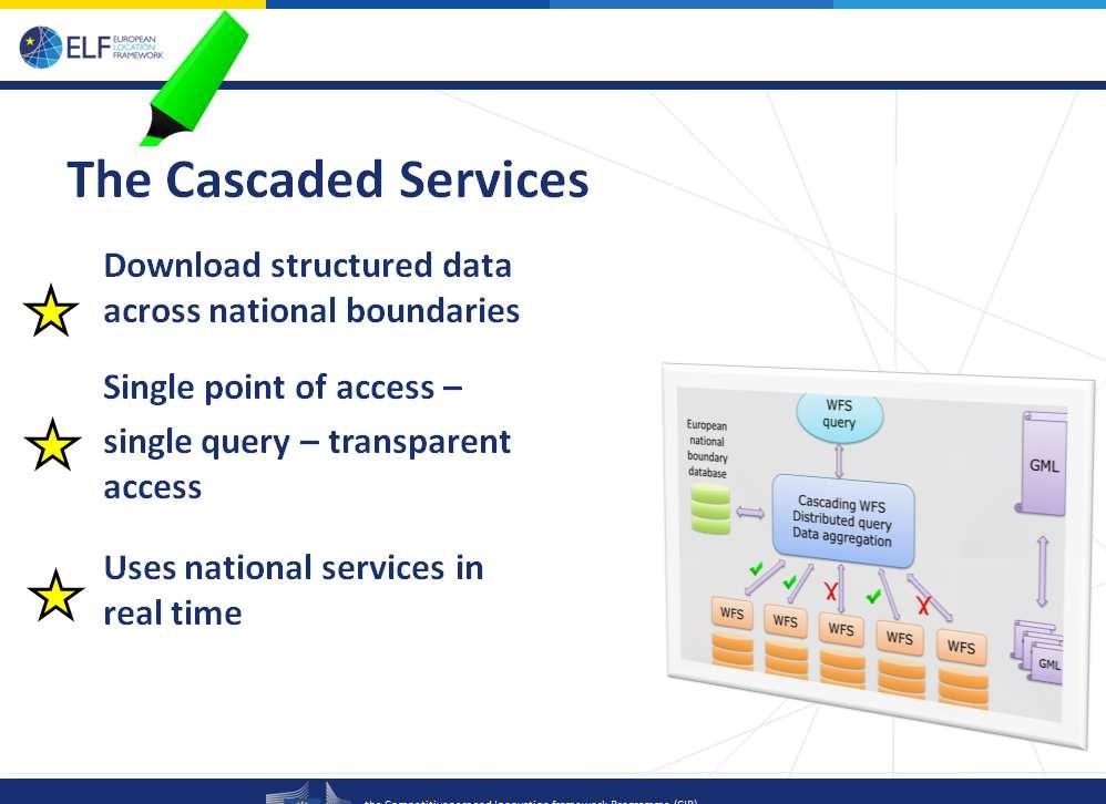
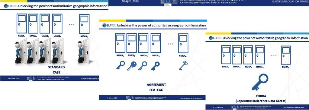
18 EEA would like being able to use the official information of the member countries, but it meets problems: - still not standardized information - different models of access to the information - different regulatory requirements CORDA Copernicus Reference Data Access portal Single access node providing links to up-to-date relevant authoritative geospatial reference data at their source


19 CORDA Datasets & Spatial Data Services Themes Administrative units Transport networks Elevation Land cover Ortho-imagery Buildings Land use Geographical names Cadastral parcels Hydrography Statistical units Demography Natural risk zones New 19
20 Imagine some flooding What is needed to monitoring the damages and to make fast mapping? Cadastral data (for example buildings) Other data and it should be possible to combine these data with other information Is flooding stoping at the border? It is necessary to: Harmonize data and services. Describe them in a common semantics. Establish agreements between the institutions. Harmonize the access Would it not be better to can achive the data with a unique access?
21 is ELF the answer? Bratislava 2016
22 Bratislava 2016 Role of National CLR Systems in the ELF-Cadastre Project 1- Introduction.Why? 2- What ELF is? 3- ELF Cadastral Index Map 4- Other ELF services 5- ELF applications 6- Access to ELF products 7- Future 8- Conclusions
23 cloud-based and cascadesupporting architecture platform that provides INSPIRE compliant geoinformation The goal of this project has been to deliver up-to-date, authoritative, interoperable, cross-border, reference geo-information for use by the European public and private sectors. The objectives are : to build a high performance platform and associated cloud services that support multiple national feeds and a wide spectrum of value-added services to demonstrate the usability of the ELF platform and cloud services for key European policy areas and other users including SMEs to develop sample applications to integrate of 3rd party thematic datasets and National Spatial Data Infrastructures for service implementations based on specific user needs

24 ELF brings INSPIRE to the practice Bratislava 2016
25
26 Bratislava 2016 Role of National CLR Systems in the ELF-Cadastre Project 1- Introduction.Why? 2- What ELF is 3- ELF Cadastral Index Map 4- Other ELF services 5- ELF applications 6- Access to ELF products 7- Future 8- Conclusions

27 14 Norway, Finland, Denmark, the Netherlands, Poland, Czech Republic, Slovenia, Spain, Lithuania, Latvia, Ireland, Hungary

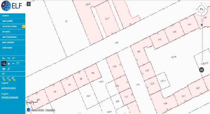
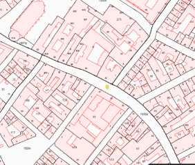
28 Cadastral Index Map ELF Cadastral Index Map is a view service that provides a simplified and harmonised view of footprints of cadastral parcels geometry combined with other basic information as administrative units, addresses and buildings for pan-european use. Service of Cascade Access from a single point Continuous map of cadastral data for the whole of Europe. CP, BU, AD, AU An European Cadaster!!

29 ELF Cadastral Index Map is not one single map layer. It is composed by themespecific map layers As data comes from different INSPIRE themes and could be provided by different NMCA s; occasionally some of them may be missing. Each theme has its layers and the styles are defined for each layer. This will also make the ELF Cadastral Index Map visualization more flexible, as the layers can be individually switched on and off. By still keeping the combined layers included we ensure the most simple possible inclusion of the ELF cadastral information in various client environments.
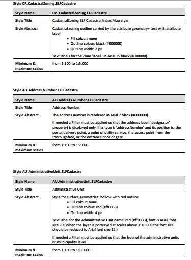
 AdministrativeUnit: Optional features: Cadastral Zoning: Cadastral Boundaries: Basic Property")
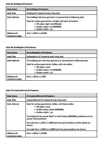
30 The main ELF Cadastral Index Map features that are represented in the layers are: Cadastral Parcel: Address: Building: Buildingpart: (if any) AdministrativeUnit: Optional features: Cadastral Zoning: Cadastral Boundaries: Basic Property Units

31 Totaly conform with INSPIRE Only is necessary to provide INSPIRE CP, BU, AD, AU WMS The European national Cadastre are very different between them It is impossible to seek the harmonization of all aspects of European Cadastres With INSPIRE only the minimum common data has been harmonized

32 In the ELF context, (as in INSPIRE) cadastral parcels will be mainly used only as locators for geoinformation. National cadastral registers generally contain much more data and users will be able through ELF Cadastral Index Map to identify the objects and obtain the national reference. to obtain other valuable information through the national services. Approximation in two steps Bratislava 2016 ELF opens the door to the national cadastres and via cadastral reference, as key attribute, may allow to find other information as owners, values, uses etc., taking into account the differences of the legal regulations of such a data in the different Member States.


33 GetFeatureInfo The national ELF services shall support the GetFeatureInfo functionality for Cadastral Parcel and Addresses. With it CIM permits to identify the features and to obtain both the national cadastral reference of the cadastral parcel, that gives users the opportunity to get more information through the cadastral national services, and the complete address of the cadastral parcel or building.
 to access the national system. INSPIRE cadastral parcel has few attributes.")
34 Two GFI-capable layers are expected: Cadastral Parcels and Addresses Bratislava 2016 link GetFeatureInfo (GFI) for cadastral parcel must return at least the national cadastral reference and if possible a hyperlink (URL) to access the national system. INSPIRE cadastral parcel has few attributes. Therefore could be possible to provide the table with the attributes and the national value of them, or leave it blank if the dataprovider does not have it. A template for the recommended GFI style in XML and HTML formats is provided at Also identify each address that is displayed in the ELF Cadastral Index Map with the GetFeatureInfo for address. These two layers can be provided either by one single WMS instance or by two separate WMS instances. Information might be provided by two different organisations.

35 Data Quality Only INSPIRE requirements The layers are those provided by NMCAs and will contain the authoritative information that shows legal or official boundaries that cannot be subjected to a process of cross-border edge-matching; it may show cadastral gaps and overlaps. Update frequency Update frequency is a key for cadastral data. NMCA should put efforts to offer up-todate content. Recommendation: If it is not possible to provide updates on a daily basis, it is recommended to provide data updated within a month of period as maximum. Quality characteristics of the services ELF Cadastral Index Map must fulfill INSPIRE requirements for view services. ELF Service Level Agreements are managed centrally through Data Provider Agreements (DPA).

36 Display Bratislava 2016
37 Portayal The representation of the ELF CIM is based on INSPIRE data specifications of each of the layers CP.CadastralParcel, CP.CadastralZoning, AD.Address AU.Administrative Unit, BU.Building, BU.BuildingPart In case that there are buildings or buildings parts below ground, the building is represented by over ground part. Address is displayed by the locator designator in the access entrance as a black text and it is recommended to locate it in the access (portal) of the building or parcel and not in the centroid of the parcel since it would overlap the parcel label. The complete address is got by getfeature info

38 Portayal ELF defines the object to be represented in each range of scales and defines the size of the text. for example CP: For scales 1: to 1: the boundaries of the Cadastral parcel are represented but without to display labels and for scales 1:100 to 1:2000 boundaries plus labels Equally, for the Administrative units layer the symbology changes for each scale range
39
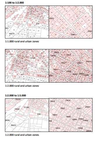
40
41 Portrayal consolidated and published at ELF portrayal repository stralmap_2.1/ GetFeatureInfo


42 ELF cadastre is the more detailed map, is accessed from other topographic maps with harmonized information for other topics of inspire as geographical names, hydrography and transport network, etc..
43
44

45
46


47 Eslovenia Liubliana Holanda: Amsterdam R CZ: Praga Dinamarca: Copenhague
48 Bratislava 2016 Role of National CLR Systems in the ELF-Cadastre Project 1- Introduction.Why? 2- What ELF is? 3- ELF Cadastral Index Map 4- Other ELF products and services 5- ELF applications 6- Access to ELF products 7- Future 8- Conclusions


49 Other ELF products and services Bratislava 2016
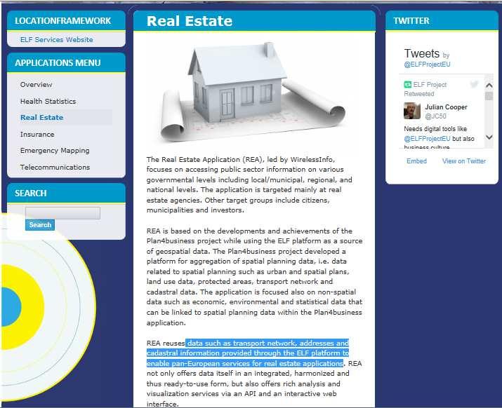
50 georeferencing service that serves multilingual European geographical names data Themes: AD, AU Use cases search functionality for place name or address returns the place name or address nearest to clicked location place name content visualized on top of other content Bratislava 2016

51 WFS Bratislava 2016

, 30+ in the pipeline")
52 ELF Direct Download services Cascades/Single access points 102 National direct download services(wfs), 30+ in the pipeline Bratislava 2016
53
54
55 Bratislava 2016 Role of National CLR Systems in the ELF-Cadastre Project 1- Introduction.Why? 2- What ELF is? 3- ELF Cadastral Index Map 4- Other ELF services 5- ELF applications 6- Access to ELF products 7- Future 8- Conclusions


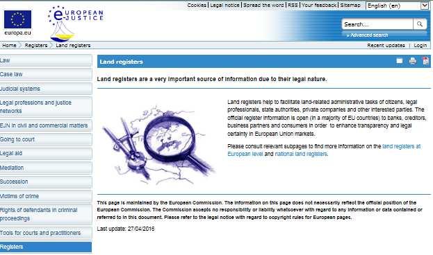
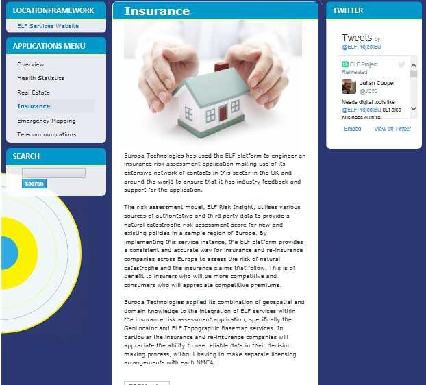
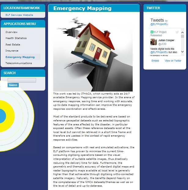
56 The ELF Cadastral Index Map and the WFS of CP, BU, AD,AU will meet the requirements of the main use cases that need CP, BU and AD as geolocators of human activities; for example: Real Estate Information Insurance risk assessment application Companies that utilize the ELF base map together with various reference data themes and hazard data layers E-justice Portal where ELF Cadastral Index Map can provide the geographic information that is needed to access to the legal information. European Land Information Service (EULIS) etc
57 Much of the value for end users resides in products and services that combine this authoritative data from the NMCAs with data from other sources and possibly even derivative information arrived at through some intelligent processing. Application developers in five pilot areas were on board from the beginning of the project. The intention remains to attract as many application developers as possible and to encourage them in making use of the ELF products and services.
58


59 ELF Real Estate Application Whatstheplan.eu update Leaflet E.L.F viewer E.L.F. Mobile Apps Etc.. E.L.F. Viewer is light thematic viewer of Thematic Maps with information relevant for spatial planning, decision process, investment and real estate. allows access maps everywhere from computers and mobiles
60

61 Europa Technologies: ELF Risk Insight: Risk model Bratislava 2016

62 Europa Technology: ELF Risk Insight: Risk Model combined with other data Bratislava 2016 Also for mobils
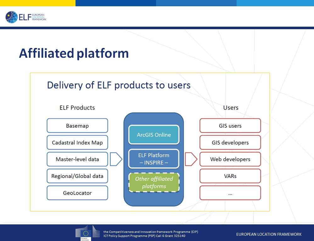
63
64
65
66

67 Cancel Enter translation Edit Bratislava 2016 Not only cartography but also thematic information: use of the building, number of dwelings etc
68
69 European E- justice Portal Do they need an map interface? Do they need access data through the map?. With the ELF cadastral Index Map?
70 A pilot project To study the opportunity to embed mapping functionality through the use of ELF Services in the online application additional functionality to the existing E-Justice Portal The inclusion of mapping will provide a richer experience to the user and allow them to validate that they are accessing the correct information
71 Bratislava 2016 Role of National CLR Systems in the ELF-Cadastre Project 1- Introduction.Why? 2- What ELF is? 3- ELF Cadastral Index Map 4- Other ELF services 5- ELF applications 6- Access to ELF products 7- Future 8- Conclusions

72 Sustainable access and use Simplify licensing and access to pan-european data. Unique access to all data Principles of ELF Licenses Simplicity Licensing must be easy to understand and apply to the user s needs Harmonised terms and conditions Incorporating the data providers national requirements ELF viewing products (WMS, WMTS) Pricing, when required, will be based on transactions (tile) or subscription ELF download products (WFS) Pricing, when required, will be based on features downloaded -
73 Access to the ELF Products Applications and affiliated platforms Geo Product Finder (Discovery and Metadata) Licensing Pricing Authentication, authorisation and accounting ELF Data and Services ELF Products
74 Bratislava 2016 Role of National CLR Systems in the ELF-Cadastre Project 1- Introduction.Why? 2- What ELF is? 3- ELF Cadastral Index Map 4- Other ELF services 5- ELF applications 6- Access to ELF products 7- Future 8- Conclusions
75

76 1 November ELF has moved into a transition phase which starts to transfer responsibility for the future of ELF to EuroGeographics. Data content providers will continue to deliver to ELF Software providers will cover license fees and support to allow the architecture to continue beyond the project for a period of 2 years (After which new contracts will have to be made) In the early stages of the transition, EG will be supported by key members of the ELF Project Management Group to ensure effective continuity with the work of the project.


77 Over time, ELF and its future development will be fully managed by EuroGeographics and its members. Continue to explore funding opportunities - likely to be a mix of funding from EU Institutions and commercial streams

78 Someone can be thinking.. It is not necessary.. My data are protected.. We don t know how We pircing Why Eurogeographics, why promote its business Yes It is provide then only the index map ELF helps you and it is only inspire, that anyway you need to do it. It is ok. Elf would pircing in the same conditions technical infrastructure Who else can do it?
79 Bratislava 2016 Role of National CLR Systems in the ELF-Cadastre Project 1- Introduction.Why? 2- What ELF is? 3- ELF Cadastral Index Map 4- Other ELF services 5- ELF applications 6- Access to ELF products 7- Future 8- Conclusions

80 Bratislava 2016 Conclusions There is a demand for cadastral data by the EC and the European citizens and businesses. Spite of the problems of heterogeneity of cadastral data in Europe, we have a solution that allow us to generate a European Cadastre that meets this demand..
81 European Location Framework (ELF): framework.eu Servicios INSPIRE de Cartografía Catastral: CORDA: UN-GGIM: EuroGeographics:http: E-justicia
82 Bratislava 2016 Questions?... Thanks a lot. Amalia Velasco Martín-Varés Dirección General del Catastro. Spain
Cadastral Parcels in the context of INSPIRE
 Cadastral Parcels in the context of INSPIRE Gyula IVÁN Institute of Geodesy, Cartography & Remote Sensing, HUNGARY Open Symposium on Environment and Land Administration Big Works for the Defence of Territory
INSPIRE Thematic Working. Cadastral parcels. September 2008
 INSPIRE Thematic Working Cadastral parcels September 2008 The INSPIRE context The INSPIRE Directive Its aim is to build the INfrastructure for Spatial InfoRmation in Europe The INSPIRE Directive has been
Cadastre and Land Registration in Europe
 Annex A: Questionnaire 2007 for Information Resource Cadastre and Land Registration in Europe Introduction This questionnaire is based on the EuroGeographics vision document 'Cadastre and Land Registration
Cadastral Parcels in INSPIRE. Lisbon, 27 February 2013
 Cadastral Parcels in INSPIRE Lisbon, 27 February 2013 Dominique.laurent@ign.fr Plan INSPIRE context The modeling approach for theme Cadastral Parcels Implementation of INSPIRE theme Cadastral Parcels Context
Recent Developments in Use and Dissemination of Geospatial Data in Germany - Example Lower Saxony
 Recent Developments in Use and Dissemination of Geospatial Data in Germany - Example Lower Saxony Conference Permanent Committee on Cadastre Lithuanian Presidency Vilnius, 22 October 2013 Peter Creuzer
Use of data in Ukraine for sustainable economic growth. Oleksandr Maliuk State Service of Ukraine for Geodesy, Cartography and Cadastre
 Use of data in Ukraine for sustainable economic growth Oleksandr Maliuk State Service of Ukraine for Geodesy, Cartography and Cadastre Kehl, 2017 Content of the presentation Ukraine & StateGeoCadastre:
The Establishment of the Cadastral Parcel as a Core Element in the European SDI - Lessons Learned and View Towards Inspiring Applications.
 The Establishment of the Cadastral Parcel as a Core Element in the European SDI - Lessons Learned and View Towards Inspiring Applications. Amalia Velasco Martín-Varés 1, Martin Salzmann 2 1 Spanish Directorate
Report and update from Working Group A on Core Data
 JOINT UN-GGIM: EUROPE ESS MEETING ON THE INTEGRATION OF STATISTICAL AND GEOSPATIAL INFORMATION LUXEMBOURG 31 MARCH 2017 Report and update from Working Group A on Core Data François Chirié, Dominique Laurent,
1st Regional INSPIRE Forum 4th Croatian NSDI and INSPIRE Day
 1st Regional INSPIRE Forum 4th Croatian NSDI and INSPIRE Day State of Play EULIS Rik Wouters Managing Director EULIS Programme What is EULIS EULIS is renewed: LINE For who is EULIS? Why EULIS? Projects
Building a European Spatial Data Infrastructure: The Role of EuroGeographics
 Building a European Spatial Data Infrastructure: The Role of EuroGeographics Richard Kirwan President of EuroGeographics 1st Congress on Cadastre in the EU 1 Presentation overview EuroGeographics - the
INSPIRE implementation as a link between egovernment and environmental purposes
 INSPIRE implementation as a link between egovernment and environmental purposes Jiří Poláček Czech Office for Surveying, Mapping and Cadastre (ČÚZK) What s to Come Role of ČÚZK branch in the INSPIRE implementation.
Challenges for the multi purpose cadastre
 Jens RIECKEN, Markus SEIFERT, Germany Key words: Multi purpose cadastre, 3d-cadastre, land use, SDI, solar cadastre SUMMARY Over the past 30 years, with the progress of information technologies the development
Land and Geographic Information, an Important Part of the Infrastructure in Sweden
 Land and Geographical Information Land and Geographic Information, an Important Part of the Infrastructure in Sweden Land and Geographic Information, an Important Part of the Infrastructure In Sweden Bo
Recent Developments concerning Land Administration in Austria
 Recent Developments concerning Land Administration in Austria Main topics e-government reference data go online / egeodata Austria new pricing and licensing / business models INSPIRE / PSI / national infrastructure
LIS a motivation for SDI initiative
 Eric Mwaikambo Ardhi University Dar es Salaam Tanzania Overview Status of LIS in Tanzania Relationship between SDI and LIS Spatial Standards LIS a motivation for SDI initiative Conclusion & Recommendations
Latest Developments in Spanish Cadastral Services to citizens and administrations
 Latest Developments in Spanish Cadastral Services to citizens and administrations Amalia Velasco Martín-Varés, Coordinadora de Relaciones Internacionales Dirección General del Catastro 1/68 Leitmotiv of
National Spatial Data Infrastructure development in Republic of Macedonia
 National Spatial Data Infrastructure development in Republic of Macedonia Sonja Dimova, state advisor for geomatics AGENCY FOR REAL ESTATE CADASTRE September 6-th, 2017, Strasbourg AREC competence for
INSPIRE implementation as a link between egovernment and environmental purposes
 INSPIRE implementation as a link between egovernment and environmental purposes Jiří Poláček Czech Office for Surveying, Mapping and Cadastre (ČÚZK) Agenda Role of ČÚZK branch in the INSPIRE implementation.
AREC responsibilities, data and registries and the way of their distribution
 Data as a basis of the digital society PCC, 13-15 March 2018, Sofia AREC responsibilities, data and registries and the way of their distribution Vlatko Dimovski Agency for Real Estate Cadastre (AREC) the
International funding projects in Republic Geodetic Authority
 International funding projects in Republic Geodetic Authority Serbia: Republic Geodetic Authority Workshop Exploring Funding Instruments for NMCA 7-8 November 2012 Republic Geodetic Authority Republic
Amalia Velasco Carlos Alonso Luis Virgos Fernando Serrano
 Inspire services of the Spanish Directorate General for Cadastre and its use to resolve an old problem of coordination between Spanish Cadastre and Land Registry. Amalia Velasco Carlos Alonso Luis Virgos
Digitalisation of the Real Property Rights Towards Spatially enabled E-Government
 Digitalisation of the Real Property Rights Towards Spatially enabled E-Government Lise Schroeder, Bent Hulegaard Jensen, Esben Munk Soerensen & Line Hvingel Istanbul, Turkey 25 june 201 Overview Introduction
Marine Spatial Data Infrastructure (MSDI) & The Marine Cadastre Application. April 10, 2018
 & The Marine Cadastre Application. April 10, 2018") Marine Spatial Data Infrastructure (MSDI) & The Marine Cadastre Application April 10, 2018 A Collaborative Pilot Project Vision of CHS: A framework of geographic data, metadata, users and tools Intent
Marine Spatial Data Infrastructure (MSDI) & The Marine Cadastre Application April 10, 2018 A Collaborative Pilot Project Vision of CHS: A framework of geographic data, metadata, users and tools Intent
DOWNLOAD ATOM SERVICES Cadastral Parcel (CP) Addresses (AD) Buildings (BU)
 Addresses (AD) Buildings (BU)") DOWNLOAD ATOM SERVICES Cadastral Parcel (CP) Addresses (AD) Buildings (BU) Version 1.0 July 2016 1 1 Description of ATOM Services... 3 2 Metadatos de los servicios... 3 3 Download ATOM services technical
DOWNLOAD ATOM SERVICES Cadastral Parcel (CP) Addresses (AD) Buildings (BU) Version 1.0 July 2016 1 1 Description of ATOM Services... 3 2 Metadatos de los servicios... 3 3 Download ATOM services technical
What s Next for Commercial Real Estate Leveraging Technology and Local Analytics to Grow Your Commercial Real Estate Business
 What s Next for Commercial Real Estate Leveraging Technology and Local Analytics to Grow Your Commercial Real Estate Business - A PUBLICATION OF GROWTH MAPS- TABLE OF CONTENTS Intro 1 2 What Does Local
The Challenge to Implement International Cadastral Models Case Finland 1
 The Challenge to Implement International Cadastral Models Case Finland 1 Tarja MYLLYMÄKI and Tarja PYKÄLÄ, Finland Key words: cadastre, modelling, LADM, INSPIRE SUMMARY Efforts are currently made to develop
New Technology for Cadastral Systems. Brent Jones, PE, PLS
 New Technology for Cadastral Systems Brent Jones, PE, PLS Benefits of Good Land Administration Key to addressing global challenges.. Secure Tenure Equitable Land and Property Taxation Support for Government
Modernizing Land Administration Systems
 Presented at the FIG Congress 2018, May 6-11, 2018 in Istanbul, Turkey Modernizing Land Administration Systems B r e n t J o n e s P E, PLS E s r i Land Administration Systems GIS is the Technology Platform
UNECE workshop on: Cadastral and real estate registration systems: Economic information for real estate markets in the UNECE region
 UNECE workshop on: Cadastral and real estate registration systems: Economic information for real estate markets in the UNECE region Roma, 5-65 6 May 2011 Maurizio Festa Agenzia del Territorio Head of Statistics
KEY REGISTERS AS BASE OF THE DUTCH SDI
 CO-151 KEY REGISTERS AS BASE OF THE DUTCH SDI BAKKER N.J. Kadaster, APELDOORN, NETHERLANDS This paper reports on the realisation of the Key Registers in the Netherlands as the foundation of the Dutch National
Fit-for Purpose Approaches to Land Administration
 Fit-for Purpose Approaches to Land Administration Brent Jones, PE, PLS Global Manager, Casastre/Land Records bjones@esri.com Land Administration GIS is the platform for land administration Land administration
Spatial Data Infrastructure in Sweden
 Spatial Data Infrastructure in Sweden Hans-Erik WIBERG, Sweden Key words: ABSTRACT Sweden was one of the first countries to address Data Infrastructure matters and have during several decades developed
Functional system for cadastral plans
 , Republic of Macedonia Key words: Cadastre, Digital plans, Data, System SUMMARY The analysis shows that the real estate market in Republic of Macedonia grows daily. With the expansion of this market increases
Test and Implementation of DATR System in Hungary
 Test and Implementation of DATR System in Hungary, Hungary Key words: unified land registry, cadastral map, Hungary SUMMARY During the last years there has been an important development in the Hungarian
The Cadastral Template 2.0, From Design to Implementation
 Abbas RAJABIFARD (Australia), Daniel Steudler (Switzerland), Ali AIEN, and Mohsen KALANTARI, Australia Key words: Cadastral Template 2.0, Cadastral Template Project, Land Administration, PCGIAP SUMMARY
Esri Middle East and Africa User Conference. December Abu Dhabi, UAE. Land Administration. Mark Baker
 Esri Middle East and Africa User Conference December 10 12 Abu Dhabi, UAE Land Administration Mark Baker Our Agenda 0900 0930 Welcome Mark Baker, Esri 0930 1030 New Directions The New Addressing System
SECTOR PUBLIC CADASTRES AND REGISTERS MARKET PARTICIPANTS
 E-SERVICES TO CITIZENS, GOVERNMENT AND BUSINESSES. LITHUANIA EXPERIENCE Arvydas Bagdonavičius State Enterprise Centre of Registers Arvydas.Bagdonavicius@registrucentras.lt REGISTERS AND IS MANAGED BY THE
PROJECT INFORMATION DOCUMENT (PID) APPRAISAL STAGE Report No.: PIDA Project Name. Region Country Sector(s) Theme(s)
 APPRAISAL STAGE Report No.: PIDA Project Name. Region Country Sector(s) Theme(s)") Public Disclosure Authorized Public Disclosure Authorized Public Disclosure Authorized Public Disclosure Authorized Project Name Region Country Sector(s) Theme(s) Lending Instrument Project ID Borrower(s)
Public Disclosure Authorized Public Disclosure Authorized Public Disclosure Authorized Public Disclosure Authorized Project Name Region Country Sector(s) Theme(s) Lending Instrument Project ID Borrower(s)
Copernicus Land Monitoring Service (Pan- European and Local) in the Netherlands
 in the Netherlands") Copernicus Land Monitoring Service (Pan- European and Local) in the Netherlands Wageningen Environmental Research (WENR) activiteiten 13 Juni 2018, Gerard Hazeu Introduction Personal note and some terminology
Copernicus Land Monitoring Service (Pan- European and Local) in the Netherlands Wageningen Environmental Research (WENR) activiteiten 13 Juni 2018, Gerard Hazeu Introduction Personal note and some terminology
Advances in Modern Land Administration Cadastre 2014 in the Year 2006
 Advances in Modern Land Administration Cadastre 2014 in the Year 2006 Winfried HAWERK, Germany Key words: E-Land Administration, IT renewal strategies SUMMARY FIG Commission 7 Working Group 7.3 deals with
Results of Central European Land Knowledge Center (CELK) Activities
 Activities") Results of Central European Land Knowledge Center (CELK) Activities András OSSKÓ, Hungary Key words :CELK Center, Property Rights and Land Market Development, Networking, direct knowledge transfer SUMMARY
Results of Central European Land Knowledge Center (CELK) Activities András OSSKÓ, Hungary Key words :CELK Center, Property Rights and Land Market Development, Networking, direct knowledge transfer SUMMARY
Land Registers Interconnection Gabriel Sima European Commission, DG Justice and Consumers
 Land Registers Interconnection Gabriel Sima European Commission, DG Justice and Consumers Contents Context LRI Project status System implementation National establishments for land registration Electronic
LAND ADMINISTRATION IN LITHUANIA: CHALLENGES AND PERSPECTIVES
 UNECE WPLA Workshop Influence of Land Administration on People and Business, Cavtat, Croatia, October 2-3, 2008 LAND ADMINISTRATION IN LITHUANIA: CHALLENGES AND PERSPECTIVES Kestutis Sabaliauskas, Director
INSPIRE Core Data. Questionnaire for EuroGeographics Cadastre & Land Registration KEN members
 INSPIRE Core Data Questionnaire for EuroGeographics Cadastre & Land Registration KEN members 1. Theme Cadastral Parcels 1.1 Geographic extent Q1: in your country, what is the geographic extent of cadastral
Unified Land Administration for a Better Spatial Infrastructure
 Unified Land Administration for a Better Spatial Infrastructure Gyula IVÁN Institute of Geodesy, Cartography & Remote Sensing FÖMI (HUNGARY) Open Symposium 30th Korean Cadastral Seminar & FIG Commission
BULGARIAN CADASTRE A GUARANTEE FOR THE OWNERSHIP RIGHTS IN IMMOVABLE PROPERTIES
 4 TH INTERNATIONAL CONFERENCE RECENT PROBLEMS IN GEODESY AND RELATED FIELDS WITH INTERNATIONAL IMPORTANCE February 28 - March 2, 2007, Inter Expo Centre, Sofia, Bulgaria BULGARIAN CADASTRE A GUARANTEE
Presented at the FIG Working Week 2016, May 2-6, 2016 in Christchurch, New Zealand
 Presented at the FIG Working Week 2016, May 2-6, 2016 in Christchurch, New Zealand The IMPULS Project Is a Project About Cooperation, Coordination, Transparency and Data Sharing A SDI project in the Western
Leasing to Finance Innovation Jurgita Bucyte Senior Adviser in Statistics & Economic Affairs, Leaseurope
 Leasing to Finance Innovation Jurgita Bucyte Senior Adviser in Statistics & Economic Affairs, Leaseurope AGORADA 2016 Brussels 27 May 2016 About Leaseurope Leaseurope represents the European leasing &
Mass Valuation: Processes & Decisions
 C+LR KEN Cadastre + Land Registry Knowledge Exchange Network Mass Valuation: Processes & Decisions Gerhard.Muggenhuber@bev.gv.at BEV - www.bev.gv.at - Federal Office of Metrology and Surveying Dept. International
EXPANDING AVAILABILITY OF BROADBAND ACCESS AND ADOPTION
 Single point information Ilija Kepevski Agency for Electronic Communications Regional Conference for Europe EXPANDING AVAILABILITY OF BROADBAND ACCESS AND ADOPTION 28-29 September 2015 - Budva, Montenegro
THE CADASTRAL PARCEL IN NSDI S AND IN INSPIRE EXECUTIVE SUMMARY
 Julio 2007 THE CADASTRAL PARCEL IN NSDI S AND IN INSPIRE EXECUTIVE SUMMARY Amalia Velasco Martín-Varés Directorate General for Cadastre INTRODUCTION A framework directive for an Infrastructure for Spatial
Agenda. Introduction to participants First Meeting UN-GGIM - GROUP OF EXPERTS ON LAND ADMINISTRATION AND MANAGEMENT UN-GE-LAM
 First Meeting UN-GGIM - GROUP OF EXPERTS ON LAND ADMINISTRATION AND MANAGEMENT Kees de Zeeuw, The Netherlands Chair Mahashe Chaka, Lesotho Co-Chair Brent Jones, ESRI (USA) -Rapporteur Agenda Opening Introduction
Institutional Arrangements In Geoinformation: Influence of Legal and Policy Issues **
 ADVANCE UNEDITED VERSION UNITED NATIONS E/CONF.103/24 ECONOMIC AND SOCIAL COUNCIL Tenth United Nations Regional Cartographic Conference for the Americas New York, 19-23, August 2013 Item 6 (a) of the provisional
CADASTRE AND LAND REGISTER Following up their relationship
 CADASTRE AND LAND REGISTER Following up their relationship Jorge López ELRA Barcelona, 16th May 2014 Principles of relationship cadastre-land register Description of properties ( A ): huge interest Ownership
Status and Perspectives of the Geodesy, Cartography and Cadastre Authority Availability of Geographic Information in Slovakia.
 Status and Perspectives of the Geodesy, Cartography and Cadastre Authority Availability of Geographic Information in Slovakia Hedviga Májovská Geodesy, Cartography and Cadastre Authority of the Slovak
The Role of National Mapping and Cadastre Agencies in Establishment of NSDI: Croatian Example
 The Role of National Mapping and Cadastre Agencies in Establishment of NSDI: Croatian Example Ljerka RAŠIĆ and Željko BAČIĆ, Croatia Key words: spatial data infrastructure, NSDI, NMCA, Inspire SUMMARY
PCC & EuroGeographics working as one more than a marriage of convenience. Dave Lovell Executive Director September 2011
 PCC & EuroGeographics working as one more than a marriage of convenience. Dave Lovell Executive Director September 2011 What is a Marriage? Marriage is a social union or legal contract in which parties
Improvement of Effectiveness Present Developments in Hungarian Land Administration
 Improvement of Effectiveness Present Developments in Hungarian Land Administration Gyula IVÁN and András OSSKÓ, Hungary Key words: Land Administration, Cadastre, Land Registry SUMMARY New Act on Surveying
Importance of Spatial Data Infrastructure in the UNECE Region. Amie Figueiredo INSPIRE Conference 2016 Barcelona, 26 September 2016
 Importance of Spatial Data Infrastructure in the UNECE Region. Amie Figueiredo INSPIRE Conference 2016 Barcelona, 26 September 2016 United Nations Economic Commission for Europe 56 member States in Europe,
REGIONAL GEOINFORMATION ENVIRONMENT REGIA
 REGIONAL GEOINFORMATION ENVIRONMENT REGIA Eglė Rimkienė Deputy Chief of Address Register Data Administration Division, State Enterprise Centre of Registers E-mail: Egle.Rimkiene@registrucentras.lt REGIONAL
CadastralparcelsforINSPIRE. Jiří Poláček
 CadastralparcelsforINSPIRE Jiří Poláček What sto come Digitization of cadastral maps in the Czech republic Workflow Description of services Challenges to be solved Implementation topics to be addressed
Semantic model for Land Registers Information: Interoperability. Jesús Camy Escobar (Project Manager)
") Semantic model for Land Registers Information: Interoperability Sofia 15th March Jesús Camy Escobar (Project Manager) Vision Efficient implementation EU Regulations Qualified and complete Information from
Semantic model for Land Registers Information: Interoperability Sofia 15th March Jesús Camy Escobar (Project Manager) Vision Efficient implementation EU Regulations Qualified and complete Information from
Topographic Signs Important Context of 3D Cadastre
 STATE GEODETIC ADMINISTRATION Gruška 20,10 000 Zagreb, Croatia Delft University of Technology Faculty of Architecture and the Built Environment Department OTB GIS Technology Section Topographic Signs Important
Property Transactions in the Digital Age. The Property Cadastre in the Context of Spatial. Dr. Jens Riecken, NRW Ministry of the Interior
 Property Transactions in the Digital Age The Property Cadastre in the Context of Spatial Data Infrastructure (SDI) Dr. Jens Riecken, NRW Ministry of the Interior Property Transactions in the Digital Age
Welcome Session warm welcome by BEV, celebrating 200 years of the Austrian cadastre CVC2017 supported by 7 organizations: WPLA EuroGeographics PCC EUL
 Swiss Federal Office of Topography swisstopo Federal Directorate for Cadastral Surveying Common Vision Conference 2017 Wrap-up CVC 2017 "Tradition meets Innovation" Vienna, Austria, 5/6 Oct. 2017 Dr. Daniel
Land Registers Interconnection Network Study. Brussels, 02/04/2014
 Land Registers Interconnection Network Study Brussels, 02/04/2014 Background Information: DG Justice Mission: To build a European Union area of Justice which ensures respect for the citizen s fundamental
EXPLORING OPTIONS FOR STANDARDISATION OF PROCESSES AND TRANSACTIONS IN LAND ADMINISTRATION
 EXPLORING OPTIONS FOR STANDARDISATION OF PROCESSES AND TRANSACTIONS IN LAND ADMINISTRATION CHRISTIAAN LEMMEN (1),(2), EVA-MARIA UNGER (2), PETER VAN OOSTEROM (3), MOHSEN KALANTARI (4) AND KEES DE ZEEUW
Property Based Land Information Systems of Turkey
 Property Based Land Information Systems of Turkey Mehmet Fatih DİRİ, Bilgehan ÖZSOY, Ünsal ERGÜN, Turkey Key words: Cadaster, Land Registry, GIS, Property, TURKEY SUMMARY The property, addition to the
A Review and Perspective on Parcel Data Models for Urban Planning
 A Review and Perspective on Parcel Data Models for Urban Planning Yiqiang Ouyang Prof. Dr. Ilir Bejleri Department of Urban and Regional Planning University of Florida June 19-21, 2010 1 Content 1. Introduction
Cadastral PLSS Stewardship December 2010 Updated December 2013
 Cadastral PLSS Stewardship December 2010 Updated December 2013 Compiled by Bob Ader, Ben Knott, and Nancy von Meyer for the FGDC Cadastral Subcommittee Table of Contents 1. Overview... 2 2. Underlying
Annual Meeting 2006 SLOVENIA, BLED RASAS GOFMANAS JAUNIUS GRIGAS RIMANTAS RAMANAUSKAS KESTUTIS TRECIOKAS
 Annual Meeting 2006 SLOVENIA, BLED LAND ADMINISTRATION IN LITHUANIA RASAS GOFMANAS JAUNIUS GRIGAS RIMANTAS RAMANAUSKAS KESTUTIS TRECIOKAS ADMINISTRATIVE STRUCTURE OF LITHUANIA HISTORY OF LAND ADMINISTRATION
Land Administration and Spatial Enablement Victoria s Experience. Chris McRae, Executive Director Land Victoria
 Land Administration and Spatial Enablement Victoria s Experience Chris McRae, Executive Director Land Victoria 4 th UN Land Administration Forum, October 2011 Outline About Land Victoria Land Victoria
Role of Republic Geodetic Authority in the Serbian geo-sector
 Role of Republic Geodetic Authority in the Serbian geo-sector Republic Geodetic Authority, Serbia www.rgz.gov.rs EuroGeographics General Assembly 2014 Moldova, Chisinau, 28 th 30 th September 2014 The
The Added Value of Geospatial Information in Disaster and Risk Management: A Case Study on the 2009 Flooding in Namibia
 The Added Value of Geospatial Information in Disaster and Risk Management: A Case Study on the 2009 Flooding in Namibia Summary Tessa Anne Belinfante, M.Sc. VU University Amsterdam Objective and Approach
Land Administration In Public Private Partnerships
 Land Administration In Public Private Partnerships Workshop Customers - Co-operation - Services Vienna, 12-13 September 2002 Peter Creuzer Content Land Administration - Tasks History Spatial Data Infrastructure
The French geoportal for Spatial plan (Géo-portail de l urbanisme): a spin-off of INSPIRE?
: a spin-off of INSPIRE?") The French geoportal for Spatial plan (Géo-portail de l urbanisme): a spin-off of INSPIRE? François Salgé - 1 - Content What is the Géoportail de l urbanisme Challenges for continuous and distributed updating
The French geoportal for Spatial plan (Géo-portail de l urbanisme): a spin-off of INSPIRE? François Salgé - 1 - Content What is the Géoportail de l urbanisme Challenges for continuous and distributed updating
Cadastral NSDI Reference Document
 Cadastral NSDI Reference Document Version 12 October 2012 FGDC Subcommittee for Cadastral Data Cadastral NSDI Reference Document Table of Contents 1. Purpose... 1 2. Business Applications... 1 3. Terminology
Building a national SDI. Approach and strategy in The Netherlands
 Agenda 1. NSDI vision and implementation strategy 2. NSDI playing field 3. Standards framework for the NSDI 4. National SDI components for IM Information model public safety SDI Portal for public safety
Utilizing 3D Building and 3D Cadastre Geometries for Better Valuation of Existing Real Estate
 Utilizing 3D Building and 3D Cadastre Geometries for Better Valuation of Existing Real Estate Umit ISIKDAG Beykent U., Turkey Mike HORHAMMER Oracle, USA Sisi ZLATANOVA, Peter VAN OOSTEROM TU Delft, The
Seminar 2 - Coordination and regulation of the Cadastre: Initiatives within the EU
 Seminar 2 - Coordination and regulation of the Cadastre: Initiatives within the EU Alessandro Annoni European Commission DG Joint Research Centre Institute for Environment and Sustainability Background
Securing Land Rights for Broadband Land Acquisition for Utilities in Sweden
 Securing Land Rights for Broadband Land Acquisition for Utilities in Sweden Marija JURIC and Kristin LAND, Sweden Key words: broadband, land acquisition, cadastral procedure, Sweden SUMMARY The European
INTEGRATED LAND ADMINISTRATION SYSTEM PROJECT PREPARATION (IBRD Advance no. P459-HR) TERMS OF REFERENCE
 TERMS OF REFERENCE") INTEGRATED LAND ADMINISTRATION SYSTEM PROJECT PREPARATION (IBRD Advance no. P459-HR) TERMS OF REFERENCE SERVICE PROVISION FOR THE SUPPORT TO THE NATIONAL SPATIAL DATA INFRASTRUCTURE (NSDI) DEVELOPMENT
INTEGRATED LAND ADMINISTRATION SYSTEM PROJECT PREPARATION (IBRD Advance no. P459-HR) TERMS OF REFERENCE SERVICE PROVISION FOR THE SUPPORT TO THE NATIONAL SPATIAL DATA INFRASTRUCTURE (NSDI) DEVELOPMENT
Spatial Data Infrastructure for knowledge sharing
 , THE NETHERLANDS Key words: SDI, knowledge sharing, people profit planet, Kadaster, system of key registers, good governance, e-government, spatially enabled society, GIDEON SUMMARY Today s global challenges
NSDI assessment for the Netherlands
 for the Netherlands Ruby Beltman, Geonovum May 24 2007 Presentation the Dutch public geo-information playing field Geonovum and the Dutch NSDI need for results The Dutch public geo-information playing
Programme. Joint Conference of PCC, EuroGeographics CLRKEN and EULIS Bratislava, Slovakia, November 2016
 Programme Joint Conference of PCC, EuroGeographics CLRKEN and EULIS Bratislava, Slovakia, 17-18 November 2016 Venue: Historical Building of the Slovak National Council, Zupne Namestie, Bratislava We are
Quality Improvement of the Real Estate Cadastre in Serbia
 , Serbia Key words: quality improvement, real estate information, quality assurance, Serbia SUMMARY The concept of cadastral modernization in the Republic of Serbia was defined in 1992, and it is being
The Cadastral Parcel Rejuvenated: Evolving from Property Unit to Core Element in Spatial Data Infrastructures
 The Cadastral Parcel Rejuvenated: Evolving from Property Unit to Core Element in Spatial Data Infrastructures Martin SALZMANN, the Netherlands Julius ERNST, Austria Key words: Cadastre; e-governance;geoinformation/gi;gsdi;land
Galicia 2009 Regional Workshop on Land Tenure and Land Consolidation. FAO s Experience with Land Development Instruments in Europe
 Galicia 2009 Regional Workshop on Land Tenure and Land Consolidation FAO s Experience with Land Development Instruments in Europe Santiago de Compostela Galicia 9-11 of February 2009 Richard Eberlin Land
Croatian SDI: a Tool for Accelerated Development of the Geo-Conscious Society
 STATE GEODETIC ADMINISTRATION Croatian SDI: a Tool for Accelerated Development of the Geo-Conscious Society Prof.Dr.Sc. Željko Bačić, Mr.Sc. Ljerka Rašić FIG Working Week 2009 - Surveyors Key Role in Accelerated
Incorporating Sustainable Development Objectives into ICT Enabled Land Administration Systems - Case Study Switzerland
 EXPERT GROUP MEETING ON INCORPORATING SUSTAINABLE DEVELOPMENT OBJECTIVES INTO ICT ENABLED LAND ADMINISTRATION SYSTEMS 9-11 November 2005, Centre for Spatial Data Infrastructures and Land Administration
Country report, HUNGARY
 Country report, HUNGARY Gyula IVÁN Institute of Geodesy, Cartography & Remote Sensing (FÖMI) HUNGARY FIG Commission 7 Annual Meeting 2009 12-16 October, 2009, Kuala Lumpur, Malaysia Institute of Geodesy,
Economic and Social Council 6 July 2018
 1 ADVANCE UNEDITED VERSION UNITED NATIONS E/C.20/2018/12/Add.1 Economic and Social Council 6 July 2018 Committee of Experts on Global Geospatial Information Management Eighth session New York, 1-3 August
Slovenian State Projects in the Field of Real Estate Registration
 Božena LIPEJ, Slovenia Key words: real estate, land cadastre, land register, modernization. ABSTRACT The making of adequate real estate policies requires well-organized real estate records which are one
Buyers Guide for the Data Service Syndicated Contract
 Buyers Guide for the Data Service Syndicated Contract Date: March 2017 CONTENTS Why use this syndicated contract? 3 Benefits 3 The strategic case 3 About the Lead Agency 4 About the Supplier 4 Roles and
The principal tasks or competencies of the General Directorate of Cadastre are:
 4th Quality Conference 1/7 1) Title of the case. Spanish e Cadastre ( Virtual Office of Cadastre, or OVC). An open space for sustainable quality in cadastral data, working with land management administrations.
Challenge to Implement International Cadastral Models Case Finland
 FIG Articleof the Month April 20 Challenge to Implement International Cadastral Models Case Finland Tarja Myllymäki and Tarja Pykälä 200-04-5 The topics are In European level INSPIRE Experiences, similarities,
New Developments in the Hellenic Cadastre
 New Developments in the Hellenic Cadastre Prof. M. Kavouras Vice-president Ktimatologio S.A. (Hellenic Cadastre) The Hellenic Cadastre Background The Hellenic National Cadastre Organizational and institutional
Best public experiences in the dissemination of cadastral information in Europe. Germany
 Best public experiences in the dissemination of cadastral information in Europe Germany Europe and Germany Europe Area: 10,2 mill. sqkm Inhabitants: 700 mill. Europe and Germany Europe Area: 10,2 mill.
GMES Land Core Services Kiew, 26th November 2008
 GMES Fast Track Service Land GMES Land Core Services Kiew, 6th November 008 Alexander Kaptein ( coordinator) European Commission Fast Track Service Land within the GMES initiative in FP-7 consortium GMES
Egyptian Nationwide Title Cadastre System
 Kholoud SAAD, Egypt Key words: Cadastre, Registration, Urban, Rural, National Cadastre, Automation, reengineering. SUMMARY With growing need for integrated information, Enterprise Solutions has become