Deb Grube Walworth County Land Use and Resource Management
|
|
|
- Cecily Edwards
- 5 years ago
- Views:
Transcription

1 Deb Grube Walworth County Land Use and Resource Management
2
3 County Zoning Contacts: Deb Grube (262) Board of Adjustment, Mobile Towers Darien, Sharon, Walworth Nick Sigmund (262) Linn, Lafayette, Spring Prairie, Geneva, Lyons, Troy, Bloomfield Shoreland Darrin Schwanke (262) Delavan, Whitewater, LaGrange, East Troy, Richmond, Sugar Creek
4 What is Zoning? Wisconsin State Statute requires Counties to effect the purposes of Wisconsin State Statute (Navigable Waters Protection Law) and to promote the public health, safety and general welfare by adopting zoning regulations for the protection of all shorelands in unincorporated areas that meet shoreland zoning standards promulgated by the DNR. (NR-115)
5 NR 115 adopted new shoreland standards on February 1, 2010 but, Walworth County has until 2016 (tentative) to adopt all of the new shoreland zoning regulations Walworth County did adopt some of the new NR115 regulations walkways to the shore was 48 wide now 60 shoreyard averaging- was property within 100 and never closer than 40 average now residences within 250 and never closer than 30 average
6 Why the delay on NR115? DNR is re-reviewing impervious surface standards. Impervious surfaces may include driveways, parking lots, sidewalks, retaining walls, rooftops, etc. DNR had public hearings in September and is currently compiling comments from the public hearings. DNR is re-reviewing mitigations standards.
7 Zoning General Rule #1 Shoreland Zoning applies to lands within 1000 feet of the ordinary high water mark of navigable lakes, ponds and flowages, and Lands within 300 feet from the high water elevation of navigable, or To the landward side of the floodplain, whichever is greater.
8 Zoning - GENERAL RULE #2 The shoreyard setback is established to preserve the natural shoreline beauty and to minimize erosion, sedimentation and impairment of fish and wildlife habitat. ANYTHING proposed within 75 of the shore is regulated. Anything within 75 of the shore will require some kind of permit.
9 Zoning - GENERAL RULE #3 Hardscapes are not Landscaping Patios - Decks Fountains/Waterfalls - Gazebo Swimming pools/spa - walkway Retaining walls - Stairway They are structures and structures are NOT generally permitted within 75 of the shore Any structure that pre-dates the ordinance is subject to review by the zoning office.
10 Common Misconceptions I bought it that way - it must be legal. If the neighbor has one, it must be legal. If the structure is temporary, or moveable I won t need a permit I just replaced what was there. I had a DNR permit for rip rap, so all of THIS shore work is included
11 VEGETATION REMOVAL No Touch within 35 of shore except: Dead, diseased or dying file an exemption form Selective removal of invasive species vegetation removal permit & conservation plan View/access corridor Vegetation removal permit & conservation plan

12 This is not trimming
13 VIEW/ACCESS CORRIDOR Corridor shall not exceed 40 in width or 30% of the lot width on lots 200 wide or less (in 30 increments for every 100 ). On lots over 200 in width, shall not exceed 20% of lot (in 30 increments for every 100 ) Existing structures determine location Stairway, boathouse, pier, etc.
14 Shoreyard Mitigation
15 Stairway/Access to shore One direct access to the shoreline (per 100 of shoreline) is permitted IF it is necessary due to steep slopes or wet unstable soils and is located in view/access corridor. Shall be installed with minimal earth disturbance & vegetation removal. Shall be limited to 60 in width and open railings only for safety purposes. Landings of 25 sq. ft. necessary for safety

16 Not steep Not wet Not allowed
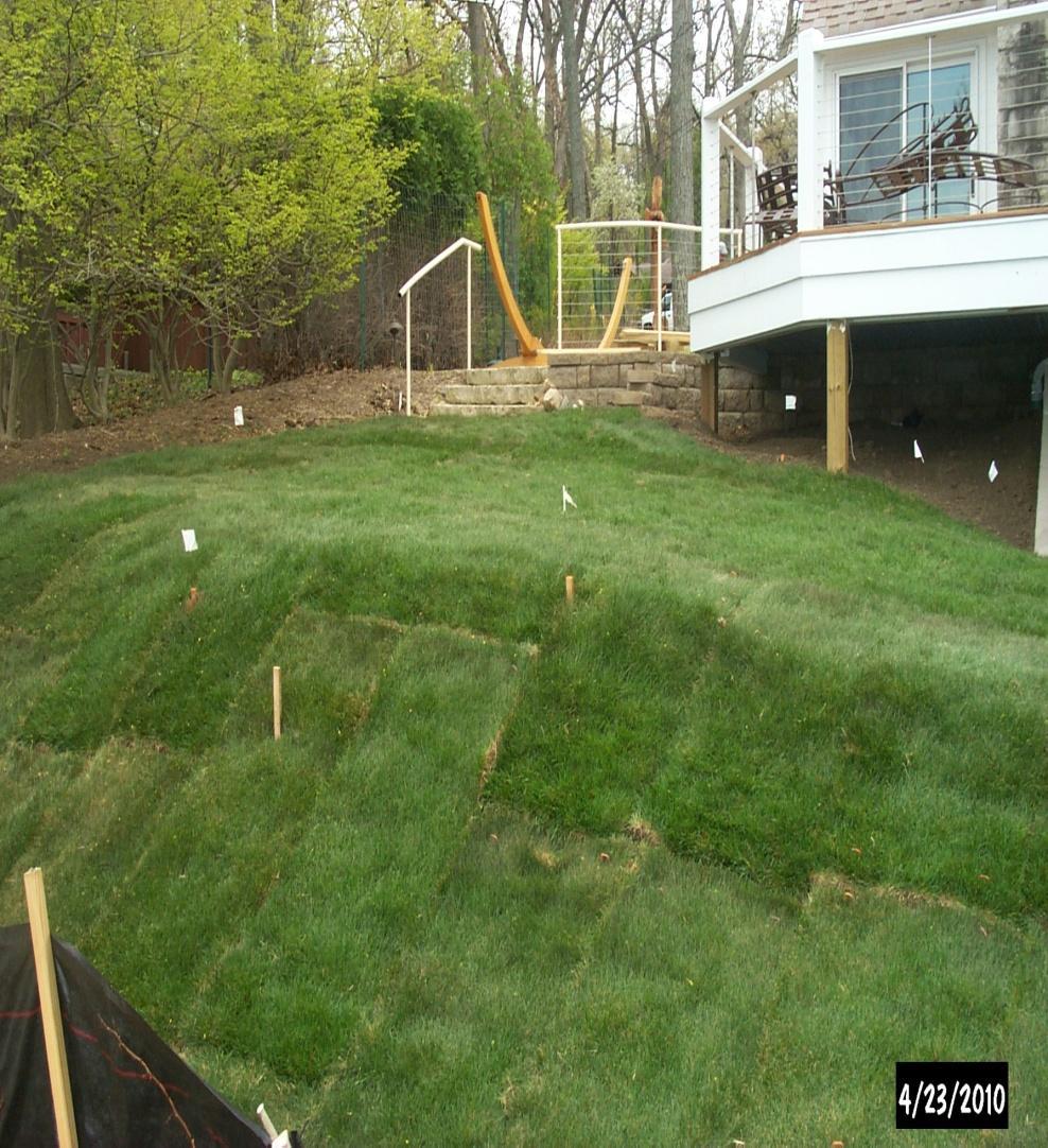
17 Geneva Lake - path Ordinance permits a public shore path parallel to the shore of Geneva Lake within the pre-1974 pedestrian easement - Needs county permits - located with minimal land disturbance - 36 width maximum - must be pervious

18 Projects can still protect wetland
19 Handicap Access in the Shoreyard The Board of Adjustment (public hearing) may grant permission to construct a deck, patio, walkway or second access to a pier in a location that would not otherwise be permitted provided: Request is by disabled person who resides on parcel Must show that a structure with smaller dimensions would not be adequate to allow the disabled person access to the residence or pier. Permit is temporary and is permitted as long as the disabled person resides on the parcel Shall be removed not more than 30 days after disabled person vacates the parcel.
20 Prescribed Burns Only permitted on parcels with more than 150 linear feet of shoreline with a plan approved by the Land Conservation Division and Only if the project can not be accomplished by selective removal of exotic, invasive, or damaged vegetation.
21 Boathouse Shall not extend below high water mark. Shall not be located on slopes of 12 percent or greater Shall be located so as to minimize land disturbing activity and vegetation removal Shall be designed EXCLUSIVELY for the storage of watercraft equipment Shall not be used for human habitation
22 RETAINING WALLS Retaining walls for the purpose of creating level living space is not permitted. Grading to create retaining walls is not permitted unless there is an erosion problem that can be proven to the Land Conservation Division. Resloping to correct an erosion problem may be permitted by LCC instead of retaining walls.

23 Level living space-not permitted
24 GRADE CHANGES (excavate/fill) Grade changes within 75 of the shore are limited to MINIMAL changes (6 or less) with permit review and approval. Grading to create level living area in the shoreyard is not permitted. Fill to create level living area in the shoreyard is not permitted.

25 Grading to create a walkout basement is not permitted in the shoreyard

26 The painful fix (with variances)

27 Filling to create a sand beach is not permitted.

28 Patio within 75 of shore Not permitted

29 Pool, spa, waterfall within 75 of the shore... Not permitted

30 It s just a... Is not permitted
31 Follow the permit as approved The zoning permit is not a guide. What is issued on the permit is what is to be built Call our office with any proposed changes Violations are subject to citations of $663 per day/ per violation.


32 It is imperative that you follow the approved permit... Before After
33 VARIANCES... The Board of Adjustment must determine whether a hardship unique to the property has been demonstrated and whether the relief requested is consistent with the public interest such that the variance should be granted, or whether a variance would subvert the purpose of the zoning restriction to such an extent that it must be denied. (Ziervogel/McGinnity v Washington Co. BOA )
34 VARIANCE CRITERIA Unique property limitations: steep slopes, drainage or waterways, wetlands, soil types, densely wooded areas, etc. Hardship: Will compliance with strict letter of ordinance unreasonably prevent owner from using the property for a permitted purpose. A Hardship cannot be self created. Absence of Detriment: Will granting the variance be contrary to public interest.
35 And SHORELAND CRITERIA Will granting the variance protect the public s interest in navigable waters, including and promoting safe and healthful water conditions, controlling pollution, and protecting fish and aquatic life and naturel shoreline beauty. (Wis. Stats (1))
36 CHANGES Substandard Lots Act 170 in conjunction with NR115 effective April 17, 2012 A legally created lot or parcel that met minimum area and width requirements when created, but does not meet current lot size requirements, may be used as a building site if all the following apply:
37 Substandard lots.... #1 The substandard lot or parcel was never reconfigured or combined with another lot or parcel by plat, survey, or consolidation by the owner into one property tax parcel. This requires staff to review permits, surveys, deeds, and other legal documents.
38 Substandard lots.... #2 The substandard lot or parcel has never been developed with one or more of its structures placed partly upon an adjacent lot or parcel. Were there permits using all the lots for proposed construction? Do the aerials show a structure across property lines without a permit?
39 Substandard lot... #3 The substandard lot or parcel is developed to comply with all other ordinance requirements. Requires the review of setback requirements, road frontage requirements, etc.
40 CHANGES Mobile Towers Act 20 Effective June 30, 2013 Telecommunication towers are now permitted in all zoning districts New Telecommunication towers no longer require a conditional use hearing
 Violations are subject to citations")
41 Thank you! Use us as a resource. Call our office for assistance Use the website: Departments Land Use and Resource Mgt County Ordinances Chapter 74 GIS Interactive Mapping (Training Provided) Violations are subject to citations Citations can be issued at $663/day/violation
42 County Zoning Contacts: Deb Grube (262) Board of Adjustment, Mobile Towers, Ordinance amendments Darien, Sharon, and Walworth Nick Sigmund (262) Linn, Lafayette, Spring Prairie, Geneva, Lyons, Troy, and Bloomfield (shoreland) Darrin Schwanke (262) Delavan, Whitewater, LaGrange, East Troy, Richmond, and Sugar Creek
WALWORTH COUNTY RESOURCE MANAGEMENT/CONSERVATION (262) Land Disturbance/Erosion Control Fay Amerson, Urban Program Specialist
 Land Disturbance/Erosion Control Fay Amerson, Urban Program Specialist") WALWORTH COUNTY LAND USE AND RESOURCE MANAGEMENT SHORELAND ZONING Michael Cotter, Director Lou Olson, Deputy Director WALWORTH COUNTY LAND USE Ph # (262) 741-4972 Fax (262) 741-4974 Deb Grube, Sr. Zoning
WALWORTH COUNTY LAND USE AND RESOURCE MANAGEMENT SHORELAND ZONING Michael Cotter, Director Lou Olson, Deputy Director WALWORTH COUNTY LAND USE Ph # (262) 741-4972 Fax (262) 741-4974 Deb Grube, Sr. Zoning
Division 2 Section to are to be renumbered as follows; deletions (strikes) and additions (underlines). DIVISION 1. Introduction.
 and additions (underlines). DIVISION 1. Introduction.") Division 2 Section 74-163 to 74-175 are to be renumbered as follows; deletions (strikes) and additions (underlines). DIVISION 1. Introduction. Sec. 74-153. - Purpose. The purpose of this ordinance is to
Division 2 Section 74-163 to 74-175 are to be renumbered as follows; deletions (strikes) and additions (underlines). DIVISION 1. Introduction. Sec. 74-153. - Purpose. The purpose of this ordinance is to
Door County Shoreland Zoning. Door County Land Use Services Department June 26, 2018
 Door County Shoreland Zoning Door County Land Use Services Department June 26, 2018 Wisconsin ShorelandZoning: Background June 12, 1968: State-mandated date for counties to begin administering shoreland
DISCLAIMER:The information contained in this document is for informational purposes only and is subject to change and/or modification at any time, by
 DISCLAIMER:The information contained in this document is for informational purposes only and is subject to change and/or modification at any time, by Walworth County, Wisconsin. Contact Walworth County
SHORELAND PROTECTION ORDINANCE FOR VERNON COUNTY, WI. Table of Contents
 SHORELAND PROTECTION ORDINANCE FOR VERNON COUNTY, WI Table of Contents Section Page 50-1.0 Statutory Authorization, Finding of Fact, Statement of Purpose and Title 3 50-1.1 Statutory Authorization 3 50-1.2
THE EVOLUTION OF SHORELAND ZONING AND WHAT IT MEANS TO SURVEYORS-ACT 55
 THE EVOLUTION OF SHORELAND ZONING AND WHAT IT MEANS TO SURVEYORS-ACT 55 I. History of Act 55 and Shoreland Zoning. A. On July 12, 2015 Governor Walker signed 2015-17 biennial budget (Act 55) which modifies
General Code of Ordinances for Marathon County Chapter 22 Shoreland, Shoreland-Wetland, and Floodplain Code. June 2016
 General Code of Ordinances for Marathon County Chapter 22, -Wetland, and Code June 2016 TABLE OF CONTENTS TABLE OF CONTENTS... i TITLE 1 SHORT TITLE, PURPOSE AND SCOPE... 1 Chapter 22.101 General... 1
Wood County Shoreland Zoning Ordinance For Wisconsin s Shoreland Protection Program
 Wood County Shoreland Zoning Ordinance For Wisconsin s Shoreland Protection Program October 1, 2014 Revised January 12, 2015 Revised September 16, 2015 (2015 Wisconsin Act 55) Revised March 2, 2016 (2015
THE COUNTY BOARD OF SUPERVISORS OF THE COUNTY OF DOUGLAS DOES ORDAIN AS FOLLOWS:
 8.4 SHORELAND ZONING ORDINANCE THE COUNTY BOARD OF SUPERVISORS OF THE COUNTY OF DOUGLAS DOES ORDAIN AS FOLLOWS: SECTION I. STATUTORY AUTHORIZATION, FINDING OF FACT, STATEMENT OF PURPOSE, AND TITLE 1.1
MENOMINEE COUNTY, WISCONSIN SHORELAND PROTECTION ORDINANCE #68. Adopted September 22, 2016
 MENOMINEE COUNTY, WISCONSIN SHORELAND PROTECTION ORDINANCE #68 Adopted September 22, 2016 Published September 28, 2016 MENOMINEE COUNTY SHORELAND PROTECTION ORDINANCE - #68 Table of Contents Section Page
City of Chilton Ch. 24 Shoreland-Wetland Zoning CHAPTER 24 SHORELAND-WETLAND ZONING. (Ord. #1106 6/17/2014, Ord. #667 8/4/87)
") CHAPTER 24 SHORELAND-WETLAND ZONING (Ord. #1106 6/17/2014, Ord. #667 8/4/87) 24.01 Statutory Authorization 2 24.02 General Provisions 2 24.03 Shoreland-Wetland Zoning District 3 24.04 Nonconforming Structures
CHAPTER 24 SHORELAND-WETLAND ZONING (Ord. #1106 6/17/2014, Ord. #667 8/4/87) 24.01 Statutory Authorization 2 24.02 General Provisions 2 24.03 Shoreland-Wetland Zoning District 3 24.04 Nonconforming Structures
Shawano County Shoreland Wetland Zoning Ordinance Draft
 Shawano County Shoreland Wetland Zoning Ordinance Draft February 25, 2016 Revised Draft with DNR Comments Table of Contents Shawano County Shoreland Wetland Zoning Ordinance... 1 1.0 STATUTORY AUTHORIZATION,
As of March 27, 2018 THE DOOR COUNTY BOARD OF SUPERVISORS DOOR COUNTY RESOURCE PLANNING COMMITTEE
 As of March 27, 2018 THE DOOR COUNTY BOARD OF SUPERVISORS Daniel Austad Helen Bacon David Englebert Roy Englebert David Enigl Kenneth F. Fisher, Vice-Chair Joel Gunnlaugsson Randy Halstead Jon Koch Susan
POLK COUNTY SHORELAND PROTECTION ZONING ORDINANCE
 POLK COUNTY SHORELAND PROTECTION ZONING ORDINANCE (Effective April 1, 2010) The County Board of Supervisors of the County of Polk does ordain as follows: Article 1. Title... 1 Article 2. Statutory Authorization...
Burnett County, WI LAND USE VARIANCE APPLICATION, EXPLANATION, & REQUIREMENTS
 Burnett County, WI LAND USE VARIANCE APPLICATION, EXPLANATION, & REQUIREMENTS A variance is a relaxation of a standard in a land use ordinance. Variances are decided by the Board of Adjustment/Appeals
STAFF REPORT. Arthur and Kathleen Quiggle 4(b)
") STAFF REPORT Application: Requests related to the construction of a 28' x 41' dwelling and 6' wrap-around open deck to replace an existing 24' x 32' cabin and wrap-around open deck and the installation
STAFF REPORT Application: Requests related to the construction of a 28' x 41' dwelling and 6' wrap-around open deck to replace an existing 24' x 32' cabin and wrap-around open deck and the installation
REGULAR ZONING ORDINANCE, WALWORTH COUNTY CODE OF ORDINANCES
 PROPOSED ORDINANCE AMENDMENTS Scheduled for Public Hearing at CZA on July 19, 2012 Additions are noted with underlines and deletions are crossed out. REGULAR ZONING ORDINANCE, WALWORTH COUNTY CODE OF ORDINANCES
Local units of government control the use of private
 9 Land Use REEB 24.085 Chapter Overview Land use issues are one of the hottest topics in the area of real estate. This chapter outlines the basics of land use regulation. Important Terminology conditional
General Zoning Requirements.
 Article B: Sec. 13-1-20 General Provisions General Zoning Requirements. (a) (b) Jurisdiction. The jurisdiction of this Chapter includes all the shorelands in the unincorporated areas of Bayfield County
CHAPTER 21 SHORELAND-WETLAND ZONING
 CHAPTER 21 SHORELAND-WETLAND ZONING 21.01 STATUTORY AUTHORIZATION, FINDING OF FACT, STATEMENT OF PURPOSE AND TITLE (1) Statutory Authorization (2) Finding of Fact (3) Purpose (4) Title 21.02 DEFINITIONS
CHAPTER 21 SHORELAND-WETLAND ZONING CODE (Cr. Ord. #764)
") CHAPTER 21 SHORELAND-WETLAND ZONING CODE (Cr. Ord. #764) 21.01 Statutory Authorization, Finding of Facts, Statement of Purpose and Title 21.02 General Provisions 21.03 Definitions 21.04 Shoreland-Wetland
CHAPTER 21 SHORELAND-WETLAND ZONING CODE (Cr. Ord. #764) 21.01 Statutory Authorization, Finding of Facts, Statement of Purpose and Title 21.02 General Provisions 21.03 Definitions 21.04 Shoreland-Wetland
NOTICE OF STATE MANDATED FEE! Approx. = $900 per Acre to Rezone A-1 Land
 NOTICE OF STATE MANDATED FEE! Approx. = $900 per Acre to Rezone A-1 Land STATE OF WISCONSIN MANDATED FARMLAND PRESERVATION ZONE DISTRICT REZONE CONVERSION FEE Beginning January 1, 2010, the State of Wisconsin
Using Shoreland Zoning to Protect Waterfront Property. Lynn Markham WI Lakes Convention April 24, 2014
 Using Shoreland Zoning to Protect Waterfront Property Lynn Markham WI Lakes Convention April 24, 2014 Enjoying healthy lakes & rivers: Part of who we are in WI 1. Introductions 2. Shoreland zoning 101
Construction & Earthwork Request Form (CERF)
") ShoreLand Traditions Construction & Earthwork Request Form (CERF) SECTION 1 SECTION 2 SECTION 3 Definitions and Points to Remember Requirements and Process Site Sketch Requirements and Sample If you have
ShoreLand Traditions Construction & Earthwork Request Form (CERF) SECTION 1 SECTION 2 SECTION 3 Definitions and Points to Remember Requirements and Process Site Sketch Requirements and Sample If you have
PLEASE READ THIS IMPORTANT INFORMATION REGARDING VARIANCE APPLICATIONS
 PLEASE READ THIS IMPORTANT INFORMATION REGARDING VARIANCE APPLICATIONS I. APPLICATION Complete the Variance Application. The Environmental Services staff will provide assistance in filling out forms and
PERMIT FEES Within the shore impact zone (Includes Rip-Rap and Sand Blankets) $ Over 51 cubic yards $100.00
 $ Over 51 cubic yards $100.00") WHAT IS A LAND ALTERATION PERMIT? A land alteration permit is a permit to move or excavate dirt, gravel, sand, etc, on property, which is not incidental to an approved building permit or a septic system
WHAT IS A LAND ALTERATION PERMIT? A land alteration permit is a permit to move or excavate dirt, gravel, sand, etc, on property, which is not incidental to an approved building permit or a septic system
AGENDA STATEMENT NO BUSINESS OF THE PLANNING COMMISSION City of Victoria, Minnesota STAFF REPORT. Casco Ventures (Developer)
") AGENDA STATEMENT NO. 17-1 BUSINESS OF THE PLANNING COMMISSION City of Victoria, Minnesota STAFF REPORT TO: Planning Commission PREPARED BY: Erin Smith, Senior Planner RE: Waterford Landing Project Rezoning
AGENDA STATEMENT NO. 17-1 BUSINESS OF THE PLANNING COMMISSION City of Victoria, Minnesota STAFF REPORT TO: Planning Commission PREPARED BY: Erin Smith, Senior Planner RE: Waterford Landing Project Rezoning
CHECKLIST INFORMATION NECESSARY FOR ZONING PERMITS
 Information for Zoning Permits (Updated: 2016.11.04 Itasca County Environmental Services 123 NE 4 th Street Grand Rapids, MN 55744 Phone: (218) 327-2857 Fax: (218) 327-7331 TDD: (218) 327-2806 Fax: (218)
** If your lot does not meet the requirements above, please read Sec below
 Sec. 13-1-60 Zoning District Dimensional Requirements. For the Zoning Dept To Issue a Land Use Permit The Following Dimensions are Required. Minimum Side and Rear Yards s Lakes Classification Minimum Class
PROCEEDINGS OF THE BOARD OF SUPERVISORS
 PROCEEDINGS OF THE BOARD OF SUPERVISORS Columbia County, Wisconsin Portage, Wisconsin September 21, 2016 7:00 p.m. The Board of Supervisors of Columbia County convened in regular session at the Carl C.
Motion by Pomush, second Hendrickson, to approve June 16, 2016, meeting minutes. Motion carried. CLAIMS CORRESPONDENCE
 PROCEEDINGS OF THE DOUGLAS COUNTY BOARD OF SUPERVISORS Thursday, August 18, 2016, 6:00 p.m., Board Room, Second Floor, Government Center 1316 North 14 th Street, Superior, Wisconsin Meeting called to order
MEMORANDUM. DATE: April 6, 2017 TO: Zoning Hearing Board Jackie and Jake Collas. FROM: John R. Weller, AICP, Zoning Officer
 MEMORANDUM DATE: April 6, 2017 TO: Zoning Hearing Board Jackie and Jake Collas FROM: John R. Weller, AICP, Zoning Officer SUBJECT: Zoning Hearing Board appeal of Jackie and Jake Collas Relief requested
SUBDIVISION APPLICATION
 SUBDIVISION APPLICATION Community Planning and Economic Development Development Services Division 250 South 4 th Street, Room 300 Minneapolis MN 55415-1316 612-673-3000 This application packet is used
Instructions to the Applicant
 CONDITIONAL USE PERMIT APPLICATION Lake of the Woods County Land and Water Planning Office 206 8 th Avenue Southeast, Suite #290 Baudette MN 56623-2867 www.co.lake-of-the-woods.mn.us Phone: (218) 634-1945
ORDINANCE NO WHEREAS, the Town of Jupiter ( Town ) has adopted a Comprehensive Plan
 has adopted a Comprehensive Plan") 0 0 ORDINANCE NO. -0 AN ORDINANCE OF THE TOWN COUNCIL OF THE TOWN OF JUPITER, FLORIDA, AMENDING CHAPTER OF THE TOWN CODE TO AMEND SECTION -, ENTITLED INTENT TO ADD PERMITTING LANDGUAGE; TO AMEND SECTION
0 0 ORDINANCE NO. -0 AN ORDINANCE OF THE TOWN COUNCIL OF THE TOWN OF JUPITER, FLORIDA, AMENDING CHAPTER OF THE TOWN CODE TO AMEND SECTION -, ENTITLED INTENT TO ADD PERMITTING LANDGUAGE; TO AMEND SECTION
(County Board to maintain a two-hour meeting limit or take action to continue meeting beyond that time.) CLAIMS
 CLAIMS") AGENDA FOR THE DOUGLAS COUNTY BOARD OF SUPERVISORS Thursday, August 18, 2016, 6:00 p.m., Board Room, Second Floor, Government Center 1316 North 14 th Street, Superior, Wisconsin (County Board to maintain
AGENDA FOR THE DOUGLAS COUNTY BOARD OF SUPERVISORS Thursday, August 18, 2016, 6:00 p.m., Board Room, Second Floor, Government Center 1316 North 14 th Street, Superior, Wisconsin (County Board to maintain
All distances unless otherwise specified shall be measured horizontally.
 Chapter 22 - LAND USE State Law reference County zoning and boards of adjustment, Wis. Stats. 59.694; zoning filing fees, Wis. Stats. 59.696; fees for zoning appeals, Wis. Stats. 59.697; floodplain zoning,
CHAPTER 6: ZONING CODE
 CHAPTER 6: ZONING CODE Table of Contents 6.1 PURPOSE.... 2 6.2 INTENT.... 2 6.3 DEFINITIONS.... 3 6.4 VILLAGE ZONING DISTRICTS.... 8 6.5 RESIDENCE DISTRICT REGULATIONS.... 8 6.6 RESTRICTIONS ON LAKE ACCESS....
Burnett County, WI SUBDIVISION VARIANCE APPLICATION, EXPLANATION, & REQUIREMENTS PROCESS (NOTE: PLEASE READ ENTIRE APPLICATION BEFORE PROCEEDING)
") Burnett County, WI SUBDIVISION VARIANCE APPLICATION, EXPLANATION, & REQUIREMENTS A variance is a relaxation of a standard in a land use ordinance. Subdivision variances are decided by the Land Use and
Burnett County, WI SUBDIVISION VARIANCE APPLICATION, EXPLANATION, & REQUIREMENTS A variance is a relaxation of a standard in a land use ordinance. Subdivision variances are decided by the Land Use and
TOWN OF LINWOOD ANOKA COUNTY STATE OF MINNESOTA ORDINANCE NO. 169
 TOWN OF LINWOOD ANOKA COUNTY STATE OF MINNESOTA ORDINANCE NO. 169 ORDINANCE AMENDING CHAPTER 8, PART 7, SECTION 2, AND SECTION 3 OF THE TOWN CODE FIFTH REVISION ADDING DEFINITIONS, REPEALING AND REPLACING
Finnerty, Shawn & Lori Water Front Setback
 BONNER COUNTY PLANNING DEPARTMENT BOARD OF COUNTY COMMISSIONERS STAFF REPORT FOR JANUARY 10, 2018 Project Name: Finnerty, Shawn & Lori Water Front Setback File Number, Type: FILE #V492-17, Variance Request
THE BUILDING PERMIT PROCESS FOR SINGLE-FAMILY DWELLINGS REVISED MAY 2006
 DEPARTMENT OF PLANNING AND ZONING Division of Inspections & Permits CUSTOMER ASSISTANCE GUIDE Visit us on the Web at: www.co.cal.md.us THE BUILDING PERMIT PROCESS FOR SINGLE-FAMILY DWELLINGS REVISED MAY
Lake of the Woods County Land Use Permit Instruction Sheet
 Lake of the Woods County Land Use Permit Instruction Sheet PROPERTY DATA SECTION Legal Description: Please write out your complete legal description. A written description on a separate sheet of paper
Land Use. Existing Land Use
 8 Land Use 8.1 Land Use Chapter Purpose and Contents This element includes a brief summary of existing land use conditions and trends followed by a series of goals, objectives, and recommendations to guide
PLANNING & DEVELOPMENT SERVICES 1800 Continental Place Mount Vernon, WA Inspections Office Fax 360.
 PLANNING & DEVELOPMENT SERVICES 1800 Continental Place Mount Vernon, WA 98273 Inspections 360.416.1330 Office 360.416-1320 Fax 360.416-1340 Date Received: Administrative Setback Reduction Checklist Pursuant
Finnerty, Shawn & Lori Water Front Setback
 BONNER COUNTY PLANNING DEPARTMENT PLANNING AND ZONING COMMISSION STAFF REPORT FOR NOVEMBER 2, 2017 Project Name: Finnerty, Shawn & Lori Water Front Setback File Number, Type: FILE #V492-17, Variance Request
Applicant s Agent Lisa Murphy, Esq. Staff Planner PJ Scully. Lot Recordation 12/01/1972 Map Book 94, Page 33 GPIN
 Property Owner and Applicant Address 3925 Shore Drive Public Hearing September 24, 2018 City Council District Bayside Agenda Item 6 Variance Request Encroachment into the Resource Protection Area (RPA)
STATUTORY AUTHORIZATION, PURPOSE AND FINDING OF FACT
 16.1 SHORELAND ZONING 16.1001 STATUTORY AUTHORIZATION, PURPOSE AND FINDING OF FACT 1) Statutory Authorization. This ordinance is adopted pursuant to the authorization contained in Sections 59.69, 59.692
Chesapeake Bay Preservation Area (CBPA) Map Update. Presentation to the County Board July 15, 2017
 Map Update. Presentation to the County Board July 15, 2017") Chesapeake Bay Preservation Area (CBPA) Map Update Presentation to the County Board July 15, 2017 Chesapeake Bay Program Comprehensive Plan Chesapeake Bay Preservation Ordinance (1992) (Chapter 61, Arlington
Chesapeake Bay Preservation Area (CBPA) Map Update Presentation to the County Board July 15, 2017 Chesapeake Bay Program Comprehensive Plan Chesapeake Bay Preservation Ordinance (1992) (Chapter 61, Arlington
SECTION 5: ACCESSORY USES
 SECTION 5: ACCESSORY USES A. In Any District Subject to the restrictions of the Zoning Resolution, a use, equipment or item customarily incidental to an existing permitted use on a lot shall also be permitted
LAKE OF THE WOODS COUNTY WETLAND CONSERVATION ORDINANCE OF 2002
 Ordinance # LAKE OF THE WOODS COUNTY WETLAND CONSERVATION ORDINANCE OF 2002 ARTICLE 1 TITLE AND PURPOSE Section 1.1. Title This Ordinance shall be known, cited and referred to as the Lake of the Woods
{{t:t;r:n;o:"signer 2";l:"Date";}}
 Application/File # Date Application Rec'd: Oct 13 2017 Fee Collected $ (for office use only) CONDITIONAL USE APPLICATION MOTLEY MN Site Address (E-911#): 164 MORRISON STREET WEST 410095000 Lake/River Name:
MULTI-FAMILY DWELLING UNIT SUBDIVISION ORDINANCE TOWN OF SIDNEY, MAINE
 MULTI-FAMILY DWELLING UNIT SUBDIVISION ORDINANCE TOWN OF SIDNEY, MAINE I. GENERAL A. Title B. Purpose C. Administration D. Scope II. DEFINITIONS A. Building Height B. Dwelling Unit C. Family D. Multi-Unit
CHAPTER 3 PRELIMINARY PLAT
 10-3-1 10-3-3 SECTION: CHAPTER 3 PRELIMINARY PLAT 10-3-1: Consultation 10-3-2: Filing 10-3-3: Requirements 10-3-4: Approval 10-3-5: Time Limitation 10-3-6: Grading Limitation 10-3-1: CONSULTATION: Each
POLK COUNTY CHAPTER 18 SUBDIVISION ORDINANCE
 POLK COUNTY CHAPTER 18 SUBDIVISION ORDINANCE Ordinance No. 13-17 Polk County Chapter 18 Subdivision Ordinance Enacted: March 21, 2017; Published: March 29, 2017 Effective Date: March 29, 2017 Polk County
ARTICLE 15 - PLANNED UNIT DEVELOPMENT
 Section 15.1 - Intent. ARTICLE 15 - PLANNED UNIT DEVELOPMENT A PUD, or Planned Unit Development, is not a District per se, but rather a set of standards that may be applied to a development type. The Planned
LAND USE PERMIT APPLICATION INSTRUCTION SHEET
 LAND USE PERMIT APPLICATION INSTRUCTION SHEET The Land Use Permit application must be carefully completed according to the following instructions. Please complete in ink or type. The appropriate fee must
Draft Zoning Changes for the 2nd Planning Board Public Hearing, January 22, 2018.
 Draft Zoning Changes for the 2nd Planning Board Public Hearing, January 22, 2018. No changes were made at the 1st Public Hearing. Proposed wording for the 1 st Public Hearing in red, eliminated text in
1105 SUBDIVISIONS, PARTITIONS, REPLATS, CONDOMINIUM PLATS, AND VACATIONS OF RECORDED PLATS
 1105 SUBDIVISIONS, PARTITIONS, REPLATS, CONDOMINIUM PLATS, AND VACATIONS OF RECORDED PLATS 1105.01 PURPOSE AND APPLICABILITY Section 1105 is adopted to provide standards, criteria, and procedures under
Lake of the Woods County Land Use Permit Instruction Sheet
 Lake of the Woods County Land Use Permit Instruction Sheet PROPERTY DATA SECTION Legal Description: Please write out your complete legal description. A written description on a separate sheet of paper
SITE PLAN REVIEW PROCEDURES SECTION DEVELOPMENTS REQUIRING SITE PLAN APPROVAL
 SECTION 22.01 PURPOSE ARTICLE XXII PROCEDURES The purpose of this Article is to establish uniform requirements of procedure for all developments in the Township. Certain specific types of minor development
Josephine County, Oregon
 Josephine County, Oregon PLANNING OFFICE 700 NW Dimmick Street, Suite C, Grants Pass OR 97526 (541) 474-5421 / Fax (541) 474-5422 E-mail: planning@co.josephine.or.us VARIANCE APPLICATION (General Development
A. Maintenance. All legally established, nonconforming structures can be maintained (e.g., painting and repairs);
;") Chapter 24.50 NONCONFORMING USES, STRUCTURES AND LOTS Sections: 24.50.010 Nonconforming uses, structures, and lots Purpose. 24.50.020 Nonconforming uses, structures, and lots Alteration or expansion of
Chapter 24.50 NONCONFORMING USES, STRUCTURES AND LOTS Sections: 24.50.010 Nonconforming uses, structures, and lots Purpose. 24.50.020 Nonconforming uses, structures, and lots Alteration or expansion of
ALEXANDRIA TOWNSHIP Land Use/Building Permit Application
 Application # Date Application Rec d / / Fee Collected $ (for office use only) ALEXANDRIA TOWNSHIP Land Use/Building Permit Application Site Address (E-911#): Parcel Number (9 digits): - - Legal Description
CHAPTER 6 CHESAPEAKE BAY PRESERVATION AREAS AND STREAM PROTECTION AREAS
 CHAPTER 6 CHESAPEAKE BAY PRESERVATION AREAS AND STREAM PROTECTION AREAS 6.1 INTRODUCTION Virginia s Chesapeake Bay Preservation Area (CBPA) Designation and Management Regulations (9VAC10-20 et seq.) require
ARTICLE FIVE FINAL DRAFT
 ARTICLE FIVE 021218 FINAL DRAFT Sec. 503.6 Open Space Preservation Option Open Space Preservation Option Open Space Preservation developments may be approved in the AR, R-1, R-2 and R-3 zoning districts,
TABLE OF CONTENTS (excerpts) Zoning Shoreland DIVISION 1.0 INTRODUCTION Purpose Intent 2
 Zoning Shoreland DIVISION 1.0 INTRODUCTION Purpose Intent 2") Ordinance Amendment for Conservation Development Design June 18,2004 SHORELAND ZONING and ZONING ORDINANCE WAL WORTH COUNTY, WISCONSIN TABLE OF CONTENTS (excerpts) Zoning Shoreland DIVISION 1.0 INTRODUCTION
Ordinance Amendment for Conservation Development Design June 18,2004 SHORELAND ZONING and ZONING ORDINANCE WAL WORTH COUNTY, WISCONSIN TABLE OF CONTENTS (excerpts) Zoning Shoreland DIVISION 1.0 INTRODUCTION
BEFORE THE SKAGIT COUNTY HEARING EXAMINER FINDINGS, CONCLUSIONS AND DECISION
 BEFORE THE SKAGIT COUNTY HEARING EXAMINER FINDINGS, CONCLUSIONS AND DECISION Applicant: Representative: File Nos: Requests: Location: Donald Hansen & Brooke Ghen 2026 Cliff Drive, Suite 157 Santa Barbara,
ARTICLE VII. NONCONFORMITIES. Section 700. Purpose.
 ARTICLE VII. NONCONFORMITIES. Section 700. Purpose. The purpose of this chapter is to regulate and limit the development and continued existence of legal uses, structures, lots, and signs established either
TALBOT COUNTY OFFICE OF PLANNING & ZONING
 TALBOT COUNTY OFFICE OF PLANNING & ZONING APPLICATION PROCEDURE FOR: MINOR VARIANCE CRITICAL AREA Refer to Article, IX, 190-182 B. Minor Variances of the Talbot County Code. If your project exceeds 10
CHARLES CITY COUNTY SITE PLAN ORDINANCE. This Ordinance shall be known as the Charles City County Site Plan Ordinance.
 CHARLES CITY COUNTY SITE PLAN ORDINANCE Section 1. Title This Ordinance shall be known as the Charles City County Site Plan Ordinance. Section 2. Authority. This Ordinance is enacted pursuant to the authority
TOWN OF ROME 1156 ALPINE DR. NEKOOSA, WI (715)
") TOWN OF ROME 1156 ALPINE DR. NEKOOSA, WI 54457 (715) 325-8012 For obtaining a Permit for SHEDS AND DECKS the following must be done before the Inspector can issue the permit: 1. County Zoning Permit -
TOWN OF ROME 1156 ALPINE DR. NEKOOSA, WI 54457 (715) 325-8012 For obtaining a Permit for SHEDS AND DECKS the following must be done before the Inspector can issue the permit: 1. County Zoning Permit -
Town of Winthrop Zoning Ordinance
 The University of Maine DigitalCommons@UMaine Maine Town Documents Maine Government Documents 2004 Town of Winthrop Zoning Ordinance Winthrop (Me.) Follow this and additional works at: https://digitalcommons.library.umaine.edu/towndocs
ZONING HEARING BOARD APPLICANTS
 ZONING HEARING BOARD APPLICANTS All applications to the Manheim Township Zoning Hearing Board shall include all of the following information. 1. One (1) application form (no copies needed), signed by the
THE COUNTY BOARD OF SUPERVISORS OF THE COUNTY OF DOUGLAS DOES ORDAIN AS FOLLOWS:
 8.1 SUBDIVISION CONTROL ORDINANCE THE COUNTY BOARD OF SUPERVISORS OF THE COUNTY OF DOUGLAS DOES ORDAIN AS FOLLOWS: SECTION I. GENERAL INTERPRETATION This ordinance shall not repeal, impair or modify private
Section 7.22: Multifamily Assisted Housing in AA-30 Residential Zone (MAHZ) [Note: an additional line will be added to the Table in Article 3, 3.1.
 [Note: an additional line will be added to the Table in Article 3, 3.1.") Section 7.22: Multifamily Assisted Housing in AA-30 Residential Zone (MAHZ) [Note: an additional line will be added to the Table in Article 3, 3.1.1A] 7.22.1 Purpose The purpose of this Special Regulation
Section 7.22: Multifamily Assisted Housing in AA-30 Residential Zone (MAHZ) [Note: an additional line will be added to the Table in Article 3, 3.1.1A] 7.22.1 Purpose The purpose of this Special Regulation
VICINITY MAP. Board of Adjustment File No.: VAR & VAR January 9, 2014 Page 2 of 11 ATTACHMENTS
 Board of Adjustment File No.: VAR2013 0024 & VAR2013 0025 January 9, 2014 Page 2 of 11 VICINITY MAP ATTACHMENTS Attachment A Applicant s Letter Attachment B Site Plan Attachment C Elevation Drawings Board
ARTICLE 9 SPECIFICATIONS FOR DOCUMENTS TO BE SUBMITTED
 ARTICLE 9 SPECIFICATIONS FOR DOCUMENTS TO BE SUBMITTED SECTION 950 GENERALLY All applications shall be properly signed and filed by the owner or, with the owner s specific written consent, a contract purchaser
R E S O L U T I O N. a. Remove Table B from the plan.
 R E S O L U T I O N WHEREAS, Werrlein Property is the owner of a 0.3902-acre parcel of land in the 5th Election District of Prince George s County, Maryland, being zoned One-Family Detached Residential
CHAPTER 14: DRIVEWAYS, TOWN HIGHWAYS, AND PRIVATE ROADS
 CHAPTER 14: DRIVEWAYS, TOWN HIGHWAYS, AND PRIVATE ROADS TABLE OF CONTENTS CHAPTER 14: PRIVATE DRIVEWAYS, TOWN HIGHWAYS AND PRIVATE ROADS 14-1 14.0100 AUTHORITY... 14-1 14.0200 TITLE... 14-1 14.0300 REGULATION
Land Use Ordinance. Town of Readfield, Maine. Adopted June 12, 2018
 Land Use Ordinance Town of Readfield, Maine Adopted June 12, 2018 Revised: March 20, 2000; June 14, 2001; September 17, 2001; June 13, 2002; June 12, 2003; September 15, 2004; June 15, 2006; June 16, 2007;
STAFF REPORT. Applicable Statutes/Ordinances: Corinna Township Subdivision Ordinance
 STAFF REPORT Application: Preliminary plat application to subdivide an approximate 6.47 acre parcel into two lots (2.81 and 3.42 acres) with a 0.24 acre remainder to be attached to an existing nonconforming
GWINNETT COUNTY CSO CONSERVATION SUBDIVISION OVERLAY DISTRICT REQUIREMENTS
 GWINNETT COUNTY CSO CONSERVATION SUBDIVISION OVERLAY DISTRICT REQUIREMENTS Section 1316. CSO Conservation Subdivision Overlay District. 1. Purposes. The purposes of this overlay district are as follows:
LAND DIVISION AND SUBDIVISION CODE. Town of Springdale Dane County, Wisconsin
 1 2 3 4 5 6 7 8 9 10 11 12 13 14 15 16 17 18 19 20 21 22 23 24 25 26 27 28 29 30 31 32 33 34 35 36 37 38 39 40 41 42 43 44 45 46 Town of Springdale Dane County, Wisconsin Chapter 3. SUBCHAPTER 1 INTRODUCTION
EXCERPTS FROM HALIFAX REGIONAL MUNICIPALITY CHARTER
 EXCERPTS FROM HALIFAX REGIONAL MUNICIPALITY CHARTER Municipal planning strategy 227 The Council may adopt a municipal planning strategy for all, or part, of the Municipality and there may be separate strategies
Comprehensive Plan 2030
 Introduction Land use, both existing and future, is the central element of a Comprehensive Plan. Previous chapters have discussed: Projected population growth. The quality housing available in the Township
CONSTRUCTION SITE EROSION CONTROL & STORMWATER MANAGEMENT JULY 3, 2014
 CHAPTER 9 Construction Site Erosion Control and Stormwater Management 10-9-1 Authority 10-9-2 Findings and Purpose 10-9-3 Applicability and Jurisdiction (1) Applicability (2) Jurisdiction (3) Exclusions
Department of Planning and Development
 COUNTY OF KENOSHA Department of Planning and Development December 2012 VARIANCE APPLICATION Owner: Mailing Address: Phone Number(s): To the Kenosha County Board of Adjustment: Please take notice that the
ZONING VARIANCES ADMINISTRATIVE
 200 W. Oak Street, 3rd Floor Fort Collins, CO 80521 (970) 498-7683 / larimer.org/planning ZONING VARIANCES ADMINISTRATIVE The submittal requirements listed in this packet are intended to collect all of
CITY OF LONG BEACH September 12, 2018
 CITY OF LONG BEACH ZONING MEETING PACKET FOR 1. Call to Order 2. Roll Call CITY OF LONG BEACH AGENDA BOARD OF ADJUSTMENT / PLANNING AND ZONING COMMISSION 3. Additions or Deletions to the Agenda 4. Public
SEWRPC COMPREHENSIVE PLANNING FACT SHEET. Land-Use Related Extraterritorial Authorities
 #95856 v1 - CP FACT SHEET- ET POWERS PCE/NMA/lgh 03/17/06 SEWRPC COMPREHENSIVE PLANNING FACT SHEET Land-Use Related Extraterritorial Authorities Cities and villages in Wisconsin have several types of extraterritorial
STAFF REPORT. Gary and Kathleen Miron. Background Information:
 STAFF REPORT Application: Variance to add a second story addition approximately 7-8 feet from a side property line (min. required 15 feet). Existing building coverage is 20.3% (max. 15% allowed). Existing
COMMUNITY DEVELOPMENT DEPARTMENT 333 Broadalbin Street SW, P.O. Box 490 Albany, OR 97321
 COMMUNITY DEVELOPMENT DEPARTMENT 333 Broadalbin Street SW, P.O. Box 490 Albany, OR 97321 STAFF REPORT Application for Site Plan Review (SP-02-18) Residential Accessory Building Ph: 541-917-7550 Fax: 541-917-7598
Administrative Penalty Order (APO) Plan for Buffer Law Implementation
 Plan for Buffer Law Implementation") Administrative Penalty Order (APO) Plan for Buffer Law Implementation June 28, 2017 This document was adopted by the Board of Water and Soil Resources (BWSR) pursuant to Minn. Stat. 103B.101, subd. 12(a)
Administrative Penalty Order (APO) Plan for Buffer Law Implementation June 28, 2017 This document was adopted by the Board of Water and Soil Resources (BWSR) pursuant to Minn. Stat. 103B.101, subd. 12(a)
Polk County Board of Adjustment October 3, 2014
 Polk County Board of Adjustment October 3, 2014 Call to Order: 10:58 A.M. Members in Attendance: Kerry Winkelmann, Robert Franks, Courtney Pulkrabek, Donovan Wright and Alternate, Rolland Gagner. Members
Chesapeake Bay Critical Area Conservation Plan
 The Maryland-National Capital Park and Planning Commission Prince George s County Planning Department Development Review Division 301-952-3530 Note: Staff reports can be accessed at www.mncppc.org/pgco/planning/plan.htm.
DOUGLAS COUNTY ZONING RESOLUTION Section 4 LRR - Large Rural Residential District 3/10/99. -Section Contents-
 SECTION 4 LRR LARGE RURAL RESIDENTIAL DISTRICT -Section Contents- 401 Intent... 4-2 402 Principal Uses... 4-2 403 Accessory Uses... 4-3 404 Uses Permitted by Special Review... 4-4 405 Land Dedication...
AGENDA. 2. Review of Agenda by the Board and Addition of items of New Business to the Agenda for Consideration by the Board
 BOARD OF ADJUSTMENT/APPEALS REGULAR MEETING October 24, 2013 7:00 P.M. Town Board Chambers, 301 Walnut Street, Windsor, CO 80550 The Town of Windsor will make reasonable accommodations for access to Town
Zoning and Building Permit Application
 Date: Zoning Permit #: County of Middlesex, Virginia Department of Planning and Community Development Zoning and Building Permit Application OFFICE USE ONLY Date: E & S Agreement #: Fee: $30.00 Approval
PROCEDURE GUIDE AND APPLICATION FOR A DEVELOPMENT PERMIT TO CLEAR AND GRADE A PARCEL OF LAND
 PROCEDURE GUIDE AND APPLICATION FOR A DEVELOPMENT PERMIT TO CLEAR AND GRADE A PARCEL OF LAND The following guide and application requirements are intended to provide adequate information about the parcel