Project Pre-Application
|
|
|
- Randolph Blankenship
- 6 years ago
- Views:
Transcription
1 Pre Application Due Date: Tues, March Draft Application Due Date: Tues, April 30, 2013 Final Application Due Date: Thurs, July 11, 2013 Project Pre-Application (Please use the Up, Down, Left & Right Arrows to move from Field to Field) Project Title: North Fork Touchet Dedloff Conservation Easement Acquisition Submitting Organization: Blue Mountain Land Trust Project Contact Information (Complete for each contact) For additional Contact Info Sheets go to: Mrs. Ms. First Name: Alison Last Name: Wesockes Address: PO Box 1473 City/Town: Walla Walla State: WA Zip: Telephone # ( 509 ) Cell # ( 509 ) address: alison@bmlt.org Project Locations: Provide a brief description of the project location including watershed, stream reach and position in watershed. The property is located about mile 9 up river from Dayton, WA on the North Fork Touchet River. It includes both sides of the North Fork and both sides of the mouth of Jim Creek from the road to the North Fork. Maps: Provide both a map illustrating project vicinity and a site map. Map descriptions can be placed in this section but maps should be attached as a separate page. (Contact SRSRB staff to construct maps and set up project in the HWS prior to pre-application deadline). Site map and vicinity map attached Short Description of Project Describe project, what will be done, and what the anticipated benefits Will be in 1500 characters or less. NOTE: Many audiences, including the SRFB, SRFB s Technical Review Panel, media, legislators, and the public who may inquire about your project use this description. Provide as clear, succinct, and descriptive an overview of your project as possible many will read these 1-2 paragraphs! The description should state what is proposed. Identify the specific problems that will be addressed by this project, and why it is important to do at this time. 1
2 Pre Application Due Date: Tues, March Draft Application Due Date: Tues, April 30, 2013 Final Application Due Date: Thurs, July 11, 2013 Describe how, and to what extent, the project will protect, restore, or address salmon habitat. Describe the general location, geographic scope, and targeted species/stock. This short description should be the summary of the detailed proposal set out under the Evaluation Proposal, with particular emphasis on questions 1-4. The PRISM database limits project descriptions to 1500 characters (including spaces); any excess text will be deleted. Additional detail should be provided in the project proposal! A conservation easement (CE) will protect 37 acres on both sides of 1/3 mile of N. Fk Touchet River and both sides of Jim Creek from N. Fk Road to the mouth, about 9 miles up-river from Dayton, WA. The project has two phases: Phase 1, in progress, is a property assessment, appraisal, and verification of absence of hazardous materials. Phase 2 includes the CE purchase as well as moving the power line out of the stream channel. The property is two parcels totaling 42 acres. One parcel has a home site and will be excluded from the CE. The remaining 37 acres will be under a permanent CE managed to protect fish and wildlife habitat and restore natural ecological function. This river is listed as a priority restoration reach by the SRSRFB and is important for steelhead and Chinook spawning. Bull trout are also present. Conifer and some hardwood species are present, and significant natural regeneration of cottonwood, alder, willow trees and other native shrubs is occurring. There is a steep slope west of the river as well as the floodplain and bottomlands. The landowners are committed to permanent protection of their property. Current zoning allows the property to be subdivided into four parcels. The CE will prevent subdivision and development, intensive grazing, timber harvest, stream channelization, flood control structures or other alteration of the natural stream course or terrain; thus allowing the stream to continue its natural restoration process. BMLT will also work with landowners to restore native vegetation. Preliminary Design Description: BMLT will contract with Columbia Rural Electric Association (REA) (owner of power line and easement) to relocate the powerline outside of the stream channel. They will be in charge of all associated costs and tasks.blue Mountain Land Trust (BMLT) will work with Confederated Tribes of Umatilla Indian Reservation (CTUIR) and the landowner to plant native vegetation where the disturbance occcurs from relocating the power line. The final conservation easement language will be negotiated with the landowner and BMLT, with RCO approval, and will be signed and recorded once everything is complete. A baseline documentation report and stewardship plan will also be created to ensure the conservation values are upheld in perpetuity. Please note that the appraisal is not yet complete, so the estimate below for the value of the conservation easement may change for the final application in July Estimated Budget: List SRFB request match and total project costs Budget Items Cost/Unit Unit Matching SRFB Request Project Cost Funds Conservation $44, $6, $37, $44, Easement Power Line relocation and plantings $17, Powerline relocation: $14,000; Plantings: $3,000 $2, $14, $17, Closing fees $2, $ $2, $2, Baseline $2, $ $1, $2, Report Stewardship $1, $ $ $1,
3 Pre Application Due Date: Tues, March Draft Application Due Date: Tues, April 30, 2013 Final Application Due Date: Thurs, July 11, 2013 Plan Administrative $3, $ $2, $3, Total Matching $ 10, Total SRFB Request $ 59, Total Project Cost $ 70, Evidence that this project is part of the Snake River Salmon Recovery Plan: List the HWS project number and title of project as stated in the 3 Year Plan. If project is not directly stated in the 3 Year Plan list the general project category your project pertains to and describe the correlation. HWS Project Number ; "Protect Riparian HabitatThrough Perminant Conservation Easements" SRFB Draft Application Information Draft Date Submitted to SRSRB Project Type: (check one) Acquisition Passage, Diversion, Barrier Inventory/Design Acquisition/Restoration Upland Non-Capital In-Stream Riparian Updated Vicinity / Site Maps & Photos Please submit photos as JPEG or other non PDF picture format. Maps and designs maybe submitted in photo or PDF format. Vicinity Map Attached: Site Map Attached: Aerial or Site Specific Photos Attached: Preliminary Designs or Field Sketches: Project Proposal Guides To complete this section download the Project Proposal template that fits your proposed project and attach as a separate document. Check appropriate box below. NOTE: This project proposal will be used primarily to evaluate your project. Please include appropriate metrics within the body of the text. The below documents can be found at Attached 1) Restoration, Acquisition and Combination (Restoration & Acquisition) Project 2) Planning Projects (Assessment, design, and Study) and Combination (Planning & acquisition) Projects 3) Barrier Inventory Projects 3
4 Pre Application Due Date: Tues, March Draft Application Due Date: Tues, April 30, 2013 Final Application Due Date: Thurs, July 11, 2013 Summary of Funding Request and Match Contribution Remember to update this section whenever changes are made to your cost estimates. TOTAL PROJECT COST (A + B) (Sponsor Match & SRFB Contribution) $70,245 A. Sponsor Match Contribution (15% minimum is required for match) Appropriation/Cash Bonds Council Bonds Voter Cash Donations Conservation Futures Donations Donated Equipment Donated Labor Donated Land Donated Materials $1,000 Donated Property Interest $9, Force Account Force Acct Equipment Force Acct Labor Force Acct Material Grants Grant Federal Grant Local Grant Private Grant State Grant IAC Grant Other Total Sponsor Match Contribution (15% Minimum Match Required of a total Project Cost) B. SRFB Contribution (grant request) $5,000 Minimum Request $10, $59, Note: *Be sure to identify the name and type of any matching grant in the Application Questionnaire Section. *The Total Project Cost must equal the totals from the following Cost Estimate Sections. 4
5 Pre Application Due Date: Tues, March Draft Application Due Date: Tues, April 30, 2013 Final Application Due Date: Thurs, July 11, 2013 Landowner Information Landowner Acknowledgment Forms (Remember to complete the Landowner Acknowledgement form for each Landowner.) To complete this section download the landowner acknowledgment form and have the landowner complete the form and submit a copy with the draft application. Draft applications without signed agreement forms may not be considered by the SRSRB for final scoring and ranking. These forms can be found on the SRSRB web site at: Current Landowner(s) of the site (name and address). Remember to complete the Landowner Acknowledgement Form. Name: Jerry and Ruth Dedloff Address: 914 N. Touchet Rd. City/Town: Dayton State: WA Zip: This is the END of the DRAFT APPLICATION. 5
6 Section 4: Project Proposals 2013 Project Proposals for Restoration, Acquisition, or Combination Restoration and Acquisition Projects North Fork Touchet Dedloff Conservation Easement Acquisition Submit this proposal as a PRISM attachment titled Project Proposal. 1. Problem Statement Provide an overview of fish resources, current habitat conditions, site or reach conditions, and other key salmon recovery problem(s) in the watershed that this project is intended to address. Within the Touchet River watershed, the river largely runs through private property. This can cause issues for critical salmon habitat, as land uses and riparian zone protection is up to each landowner. In Columbia County, much of the watershed has zoning allowing for four houses every 40 acres. This could be extremely detrimental for habitat; as fragmentation, poor riparian zone health, warming waters, and stream channelization could all occur. Current riparian conditions on this property are good. This property has been logged in the past and is lightly stocked with conifer and some hardwood species. There is significant natural regeneration of cottonwood, alder, willow trees and other native shrubs currently taking place adjacent to the streams. Protecting this property with its healthy river and riparian conditions is important for critical steelhead spawning. This reach is listed as an MSA priority protection reach by the Snake River Salmon Recovery Funding Board. Fish data for this stretch of the North Fork show the significance of this stretch for salmonoids. The Lyons Ferry Complex Hatchery Evaluation: Summer Steelhead Annual Report 2005 Run Year, printed in June 2007, estimates effective breeders in the Upper Touchet River from In 2005, there were 15 redds counted specifically on the stretch of property proposed for a conservation easement. Densities of natural origin juvenile steelhead/rainbow trout were taken using electrofishing sites; one of these sites was directly behind the Dedloff s home. At this site, the density was fish/100m 2, age 0; and fish/100m 2, age 1+. Project Purpose When answering the questions below, please refer to Chapter 4 of the Stream Habitat Restoration Guidelines (wdfw.wa.gov/publications/pub.php?id=00043) for a definition of restoration goals and objectives. A. State the project goal(s). Salmon Recovery Grants Manual 18 January 2013
7 Section 4: Project Proposals Project goals include protecting the healthy, high-quality fish and wildlife habitat on this site and ensuring that it remains healthy habitat in perpetuity. As explained in Chapter 4 of the Stream and Habitat Restoration Guidelines, Preservation of relatively intact, functioning ecosystems is a far more cost-effective approach to conserving the integrity of biological communities than restoring an ecosystem after it has been degraded (p. 6). B. List the project s objectives. Objectives include protecting the conservation values of the property in perpetuity with a conservation easement. Also, in order to enhance stream quality and protect riparian vegetation, the power line will be moved out of the stream channel and further upland to be next to the road. 2. Project Context A. Describe the location of the project in the watershed, A protective conservation agreement will be established over 37 acres of land on both sides of 1/3 mile of North Fork Touchet River and both sides of Jim Creek from the North Fork Road to the mouth, about 9 miles up-river from Dayton, WA. The property is about 42 acres in total, in two parcels. One parcel, 5.12 acres, has a home and yard. This part of the property would not be included in the conservation easement. The remainder of the property, acres, would be entirely within a conservation easement managed to protect aquatic values, fish and wildlife habitat, and open space. This river is considered important for steelhead spawning and is listed as a priority protection reach by the Snake River Salmon Recovery Funding Board. Approximately 22 acres of the property (59%) is riparian habitat. There is significant natural regeneration of cottonwood, alder, willow trees and other native shrubs currently taking place adjacent to the streams. In addition to the floodplain and bottomlands, there ar approximately 15 acres of a steep lightly timbered east-northeast facing slope above the river on the property. Much of the uplands also contribute to in-stream flow and water quality, as water flows down the upland reaches into the water table at least part of the year. Salmon Recovery Grants Manual 18 January 2013
8 Section 4: Project Proposals B. List the fish resources present at the site and targeted by this project. Species Mid- Columbia Summer Steelhead Spring Chinook Salmon Life History Present (egg, juvenile, adult) Spawning and Rearing Spawning and Rearing Current Population Trend (decline, stable, rising) ESA Coverage (Y/N) Stable Y All Stable (introduced) Y All Life History Target (egg, juvenile, adult) Bull Trout Juvenile, adult Stable Y Juvenile, adult C. Discuss how this project fits within your regional recovery plan and local lead entity s strategy to restore or protect salmonid habitat in the watershed The Snake River Salmon Recovery Plan has identified a strategy to restore and protect salmonoid habitat. This project is within a Priority Restoration Reach, and is important for Steelhead and Chinook spawning. Protecting habitat through conservation easements is also listed as HWS Project Number ; "Protect Riparian Habitat through Permanent Conservation Easements. D. Explain why it is important to do this project now instead of at a later date. Protecting this reach is critical to complete now for many reasons. This stretch of the Touchet River runs its natural course, and has a wide diversity of riparian vegetation. Acting quickly and diligently is important when a landowner expresses interest in permanent property conservation, because successive landowners may not have the same land ethic, and could potentially severely degrade the prime habitat conditions that currently exist. Protecting intact, functioning ecosystems is far more costeffective than trying to restore it later on once degraded. In addition, a conservation easement is a much more affordable option for conserving quality habitat compared to purchasing land in fee simple. Lastly, land value will only continue to increase, indicating that protecting it now will be more cost-effective than waiting until future years when the value is even higher. Salmon Recovery Grants Manual 18 January 2013
9 Section 4: Project Proposals E. If any part or phase of this project previously has been reviewed or funded by the SRFB, please fill in the table below. Project # or Name # Status Completed In Process Not Funded* Completed In Process Not Funded* Completed In Process Not Funded* Status of Prior Phase Deliverables and Relationship to Current Proposal? This application was for Phase 1, project assessment, and was an alternate for funding. BMLT found funding elsewhere to move forward with the assessment, and is now applying for easement acquisition and protection (Phase 2). 3. Project Description Please answer the questions below and all pertinent supplemental questions. A. Provide a detailed description of the proposed project, including project size, scope, design, and how it will address the problem(s) described above. The major restoration component for this project is removing the power line from the stream channel, and relocating it near the road, out of the lowlands. The current utility easement on this property allows the power company to clear the area within their easement (including the stream channel and riparian area) for purposes of line maintenance. Relocating the power line will ensure that the power line easement will not affect the conservation values in the proposed conservation easement. Additionally, native vegetation will be planted to rehabilitate the ground once the power line is moved. Beyond that, the main task of this project is placing the property under a permanent conservation easement, to be maintained and monitored in perpetuity for fish and wildlife habitat and water quality. N/A B. If this project includes measures to stabilize an eroding stream bank, explain why bank stabilization at this location is necessary to accomplish habitat recovery. C. If restoration or acquisition will occur in phases or is part of a larger recovery strategy, describe the goal of the overall strategy, explain Salmon Recovery Grants Manual 18 January 2013
10 Section 4: Project Proposals individual sequencing steps, and which of these steps is included in this application. Acquisition of this conservation easement is phase 2 of 2. The first phase included an assessment of the property to determine conservation easement value, confirm the absence of hazardous materials, title search, survey the property, and assess full inventory of conservation values, as well as negotiate permitted and prohibited uses with the landowners. Protecting this property also aligns with BMLT s strategic Land Conservation Plan (completed 2013), the goals of the Snake River Salmon Recovery Board, and goals of the Confederated Tribes of the Umatilla Indian Reservation. D. Describe the long-term stewardship and maintenance obligations for the project or acquired land. Long term stewardship and maintenance obligations for this project includes BMLT upholding the terms of the conservation easement with the landowner in perpetuity. This requires at least annual monitoring, as well as additional habitat enhancement projects as needed. Restricted uses on the property once the conservation easement is in place include no sub-dividing or developing the property; no stream channelization or instream structures; no grazing in the stream channel or surrounding riparian vegetation; no motorized vehicle use in the riparian area; and no other activities that would damage or impede the water quality and fish habitat. For a full list of proposed prohibited land uses, see attachment. E. Describe other approaches and design alternatives that were considered to achieve the project s objectives and why the preferred alternative was selected. Realizing the value of critical habitat in healthy condition, BMLT has determined that waiting is not a good alternative. There is no way to know what the motives and desires of successor landowners on this parcel will be if it is not protected in perpetuity via a conservation easement. In addition, conservation easements achieve the goals of protecting and enhancing critical fish and wildlife habitat while maintaining private ownership. This makes the transaction more cost-effective compared to fee simple purchase. Another alternative is not pursuing property protection, allowing local zoning and ordinances to protect the property. This is not a favorable solution, as zoning and ordinances can change; and current zoning would allow three additional homes on the property. F. List all landowner names. Jerry Dedloff Jr.; Ruth Dedloff Salmon Recovery Grants Manual 18 January 2013
11 Section 4: Project Proposals G. Has the Washington Department of Natural Resources confirmed that your project is or is not on state-owned aquatic lands? Yes, it is not state-owned aquatic lands. H. List project partners and their role and contribution to the project. CTUIR will contribute $1,000 of in-kind match through donation of native plants to vegetate the disturbed area after Columbia Rural Electric Association (REA) moves the power line. The landowner is the other provider of matching funds, donating a portion of the easement value to the project. I. Stakeholder Outreach: BMLT just completed our land conservation plan, allowing for more strategic conservation. There were multiple outreach components included in plan development, including workshop meetings and a public survey. The consensus is overwhelmingly supportive of conserving properties such as this; properties that enhance the community by providing habitat for fish and wildlife; preserving the viewshed; and enhancing water quality. While this project was not directly discussed (due to privacy of landowners), we are confident that community members will support this conservation easement. J. Contingency Planning: The only foreseeable delay may come from working with Columbia REA to relocate the power line. We will ensure this occurs at the best time of year for the lowest impact to fish and wildlife, which may extend the SRFB funding timeline for completing the grant. Hopefully this is not the case, and the project can move forward in a timely fashion. K. List and describe the major tasks and time schedule you will use to complete the project. Major tasks include final negotiations for easement language with landowners and RCO; Creating the Baseline Documentation Report; Creating the Stewardship Plan; Relocating the Power line; planting native vegetation to restore area impacted by power line relocation; and recording the conservation easement. Once funding is received from RCO, BMLT and the landowners are ready to move forward. We anticipate completing all major tasks within 12 months of funding awarded. 4. Design and Implementation Questions for Restoration Projects (Acquisitiononly projects need not respond to these questions.) A. Will the project design be (or has it been) developed by a licensed professional engineer? Salmon Recovery Grants Manual 18 January 2013
12 Section 4: Project Proposals Columbia Rural Electric Association will take care of all work and engineering associated with moving the power line. They will then bill BMLT and we will pay them for their services. BMLT will work with CTUIR to develop the restoration planting plan for the area disturbed by the power line move. B. Describe your experience managing this type of project. Blue Mountain Land Trust holds 10 conservation easements, six of which have been funded through the Salmon Recovery Funding Board. Many of these easements had a restoration component as well as acquisition. Therefore, BMLT is well versed in expectations, timelines, associated paperwork, and requirements associated with sound conservation easement transactions. We are a non-profit organization with stewardship funds held in investments designed for long-term stewardship and easement enforcement. BMLT is assisted by a 10 person Board of Directors including attorneys, an accountant, a wildlife manager, and others; as well as staff. Alison Wesockes, the conservation director, has been directly involved with monitoring all 10 easements, as well as completing two SRFB funded conservation easements in She is also working to complete another easement in 2013, funded through WA RCO. N/A N/A N/A C. Describe who will provide construction management for the project. D. The design process for restoration projects is expected to follow that described in RCO Manual 18, Salmon Recovery Grants, Appendix D 1-4. If your process or your design deliverables differ from those expectations, please describe your process and design deliverables and how they differ. E. Describe how you anticipate documenting as-built conditions. F. Describe the steps you will take to minimize the introduction and spread of invasive species during construction and restoration. Columbia REA will be handling all construction associated with moving the power line. We will ask them to pressure-wash all equipment before bringing it on site. Then, we will quickly replant the disturbed area with native vegetation to reduce the possibility for invasive species establishment. Salmon Recovery Grants Manual 18 January 2013
13 Section 4: Project Proposals Supplemental Questions Acquisition Project Supplemental Questions (Applies to both acquisition-only and combination projects). Answer the following supplemental questions (these are not included in the ten-page limit): A. Provide a detailed description of the property. This parcel contains both sides of 1/3 mile of the North Fork Touchet, with an existing wide riparian buffer. This parcel also contains the alluvial fan of Jim Creek at the confluence of Jim Creek and the North Fork. This is a dynamic reach that will continue to develop high quality habitat with the protection of riparian areas and allowing space for channel migration. It also contains the 100-year flood zone, all of which would be under conservation easement. Existing land use is minimal; there is a garden area near the road but beyond that, the property is mostly left natural. The adjacent parcel, with the same landowners, has a home site that will not be in the easement. B. State what type of acquisition is proposed (e.g., fee title, conservation easement). Conservation Easement C. State the size of the property to be acquired acres Describe the property s proximity to publically owned or protected properties in the vicinity. The attached vicinity map shows the existing conservation easements in the area, as well as the National Forest Lands to the east and south. D. If uplands are included on the property to be acquired, state their size and explain why they are essential for protecting salmonid habitat. About 15 acres of the property is uplands. These uplands are adjacent to the North Fork and protection of these lands from development, including logging and road building, is necessary to prevent sedimentation into the river. In addition, there are two main draws in the uplands that provide water to the water table at least seasonally. Protecting these water sources also contributes to good water quality for salmonoids. Salmon Recovery Grants Manual 18 January 2013
14 Section 4: Project Proposals E. State the percentage of the total project area that is intact and fully functioning habitat. 100% Explain property restoration needs. There are no levees, riprap, infrastructure, or other features on this property that inhibit channel migration or floodplain-stream interaction. The only restoration will be related to power line relocation. F. List structures (home, barn, outbuildings, fence) on the property and any proposed modifications. The current landowners have a home on an adjacent parcel that will not be included in the conservation easement. On the parcel under conservation easement, there are no homes, one outbuilding, and a garden area. There are also some remaining fence posts from when cattle used the property. G. Describe adjacent land uses (upstream, downstream, across stream, upland). Directly upstream from this site is Teancum Timbers, a camping and recreational area owned and operated by the Church of Jesus Christ of Latter Day Saints. There are a few additional private landowners, and then approximately five miles upstream is the United States Forest Service Boundary. Directly downstream from the project location, there are private landowners with some agricultural use, as well as another event/retreat center about a mile downstream. H. Describe the: i. Zoning/land use Zoning is AR-2 Agriculture Zone, meaning four houses per 40 acres ii. iii. Shoreline Master Plan designation Portion of site within 100-year floodplain 40-50% iv. Portion of site within designated floodway Approximately 5% (using the high bank line shown on survey) I. Explain why federal, state, and local regulations are insufficient to protect the property from degradation. Salmon Recovery Grants Manual 18 January 2013
15 Section 4: Project Proposals Shoreline and critical areas regulations, along with county zoning, have not been well enforced in the area and single-family dwellings are exempt from State Shoreline regulations. Accessory structures can locate within 35 feet of the stream although the critical areas ordinance restricts home development to 200 feet from the stream bank. The riparian area on this property is larger than 200 feet from the stream, so much could be lost if structures were allowed, even if they were following regulations. J. For projects that have a goal of saving water: N/A K. If buying the land, explain why acquiring a conservation easement to extinguish certain development, timber, agricultural, mineral, or water rights will not achieve the goals and objectives of the project. N/A L. For acquisition projects intending to purchase multiple properties within an area, identify all the possible parcels that will provide similar benefits and certainty of success and provide a clear description of how parcels will be prioritized and how priority parcels will be pursued for acquisition. N/A Salmon Recovery Grants Manual 18 January 2013
16 North Fork Touchet Dedloff Conservation Easement Acquisition Proposed Prohibited Uses for Conservation Easement Blue Mountain Land Trust 2013 The following uses of, or activities on, the Property, though not an exhaustive list, are inconsistent with the Purpose of the proposed Conservation Easement, and shall be prohibited. Subdivision: The legal or de facto division, subdivision or partitioning of the Property by which the Property is divided into lots or in which title to different portions of the Property are held by different owners is prohibited. Construction: The placement or construction of any buildings, or structures of any kind (including, without limitation, pipeline, wells, recreational vehicles, septic systems, drain field, fences, roads, trails and parking areas) is prohibited except as provided in Section V of the Conservation Easement. Removal of Trees and Other Vegetation: The pruning, cutting down, or other destruction or removal of live and dead trees and other vegetation is prohibited except as expressly provided in Section V of the Conservation Easement; or with the prior written approval of the BMLT to preserve, protect, restore or enhance the Conservation Values. Residential Use: Use of the Property for any residential purposes, or construction of additional residential or outbuildings is prohibited. Industrial Uses: Use of the Property for any industrial purpose is prohibited. Agricultural Activities: Use of the Property for any commercial agricultural activity is prohibited. Commercial Uses: Use of the Property for any commercial purpose is prohibited. Commercial Recreational Activity: Use of the Property for any commercial recreational activity (as such terms are defined by Section 2031(c)(8)(B) of the Code and the applicable Treasury Regulations) is prohibited. Utilities: The installation of new utility systems or the extensions of existing utility systems, including, without limitation, water, sewer, power, fuel, and communication lines and related facilities, is prohibited unless approved in writing by BMLT and determined to have no significant impact on conservation values. 1
17 Alteration of Land: The alteration of the surface of the land, including, without limitation, the excavation, fill or removal of soil, sand, gravel, rock, peat, or sod, except as expressly allowed in Section V of the Conservation Easement is prohibited. Alteration of land may be permitted with the prior written approval of BMLT to preserve, protect, restore, or enhance the Conservation Values. Alteration of Water Courses: The draining, filling, dredging, ditching, or diking of wetland areas, the creation, alteration or manipulation of ponds, the diking or riprapping of North Fork Touchet or Jim Creek, or the creation of new wetlands, water impoundments, or water courses is prohibited except with the prior written approval of the BMLT to preserve, protect, restore or enhance the Conservation Values. This provision shall not be interpreted to prohibit irrigation or diverting, collecting, storing, or transporting water pursuant to existing or new water rights. Erosion or Water Pollution: Any use or activity that causes or is likely to cause significant soil degradation or erosion or significant pollution of any surface or subsurface waters is prohibited. Feedlots: The establishment and maintenance of a commercial feedlot is prohibited. Waste Disposal: The disposal, storage, release or abandonment of rubbish, garbage, debris, vehicles, abandoned equipment, parts thereof, or other unsightly, offensive, or Hazardous Substances on the Property is prohibited. Signs: The placement of commercial signs, billboards, or other advertising material on the Property is prohibited; except that signs may be placed on the Property to identify the Property, to advertise for sale or rent, to state the condition of access to the Property, to describe the natural features of the Property, or to acknowledge the placement of the Conservation Easement on the Property, provided that such signs are less than twenty four (24) square feet in area per side and are located to preserve, as much as possible, the scenic Conservation Values of the Property. Mining: The exploration for, or development and extraction of, minerals and hydrocarbons on or below the surface of the Property is prohibited. Wildlife Disruption: The intentional disruption of wildlife breeding, foraging and nesting activities is prohibited. This prohibition will not be construed to prohibit hunting on the Property. Introduced Vegetation: The intentional introduction of nonnative invasive species or the planting or introduction of any non-native species of vegetation is prohibited. An exception can be made with the prior written approval of BMLT if the planting is to restore or enhance the Conservation Values. Planting of nonnative vegetation within 2
18 the Riparian Zone shall be done only as a temporary measure to promote establishment of native vegetation. Harvest of Native Plants: The commercial gathering, picking, taking, or harvesting of native plants, or any parts thereof, from the property is prohibited. Off-Road Vehicles: The operation of motorcycles, ATV s, dune buggies, snowmobiles, or any other type of motorized recreational vehicles, or the operation of other sources of compaction or erosion that could adversely impact the Conservation Values of the Property is prohibited. An exception is that motorized vehicles may be used for habitat enhancement, or maintenance purposes provided that the Conservation Values of the Property are not adversely impacted by such use. Water Rights: The exercise of reserved water rights in a manner that would materially impact or degrade the Conservation Values of the Protected Property is prohibited. 3

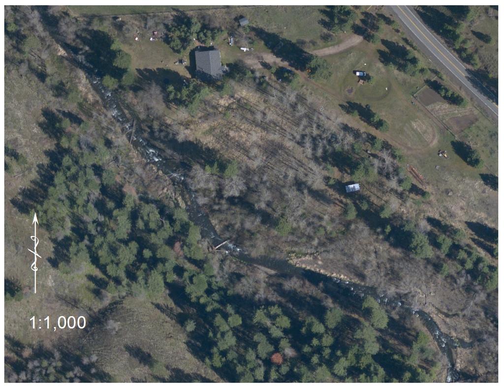
19 North Fork Touchet Dedloff Conservation Easement Acquisition 2013 SRFB Application Maps Map 1: Site Map 1
 and upland")

20 Map 2: Showing portion of property that is riparian (shaded) and upland (non-shaded) Map 3: Proximity Map. Shows relative location to USFS, other BMLT conserved land 2
21

22

23 Side Channel Complexity

24 feet meters
25
26
27
Georgia Conservation Tax Credit Program Frequently Asked Questions
 Georgia Conservation Tax Credit Program Frequently Asked Questions What are the minimum requirements for eligibility under the Georgia Conservation Tax Credit Program (GCTCP)? Individual and corporate
Sample Baseline Documentation Report (BDR) Annotated Template for Environmentally Important Land
 Annotated Template for Environmentally Important Land") Sample Baseline Documentation Report (BDR) Annotated Template for Environmentally Important Land The baseline documentation report (BDR) provides a snap shot of the biophysical condition of a property
Sample Baseline Documentation Report (BDR) Annotated Template for Environmentally Important Land The baseline documentation report (BDR) provides a snap shot of the biophysical condition of a property
M2 Mid Sugar Acquisition
 Upper Columbia Regional Application 2017 M2 MidSugar Acquisition Methow Salmon Recovery Foundation (MSRF) PO Box 755, Twisp, WA 98856 Chris Johnson, (509) 4291232, chrisj@methowsalmon.org PRISM # 171180
Conservation Easement Stewardship
 Conservation Easements are effective tools to preserve significant natural, historical or cultural resources. Conservation Easement Stewardship Level of Service Standards March 2013 The mission of the
Submittal of the Minutes from the March 9, 2011, April 5, 2011, and April 19, 2011 Cabinet Meetings.
 AGENDA BOARD OF TRUSTEES OF THE INTERNAL IMPROVEMENT TRUST FUND JUNE 16, 2011 Attachments to the items below can be viewed at the following link: http://www.dep.state.fl.us/secretary/cab/public_notices.htm
Appendix G. Non-Federal Letters of Support and Draft Real Estate Plan
 Appendix G Non-Federal Letters of Support and Draft Real Estate Plan REAL ESTATE PLAN UPPER DELAWARE RIVER WATERSHED FEASABILITY STUDY LIVINGSTON MANOR, NEW YORK 1. GENERAL 2. REAL ESTATE REQUIREMENTS
DEPARTMENT OF THE ARMY OFFICE OF THE CHIEF OF ENGINEERS WASHINGTON, D.C
 DEPARTMENT OF THE ARMY OFFICE OF THE CHIEF OF ENGINEERS WASHINGTON, D.C. 20314-1000 REPLY TO ATTENTION OF: CECW-PM (10-1-7a) THE SECRETARY OF THE ARMY 1. I submit for transmission to Congress my report
Stormwater Ordinance Appendix APPENDIX K EXAMPLE TAR-PAM CONVERSATION EASEMENT
 APPENDIX K EXAMPLE TAR-PAM CONVERSATION EASEMENT Tax Parcel ID # NORTH CAROLINA FRANKLIN COUNTY CONSERVATION EASEMENT Franklin County, North Carolina THIS CONSERVATION EASEMENT (this "Conservation Easement")
THIS DECLARATION OF RESTRICTIVE COVENANTS is made this day of, 20, by ("Covenantor"). RECITALS
. RECITALS") Model for Use with Permits Without Mitigation Plans STATE OF COUNTY OF DECLARATION OF RESTRICTIVE COVENANTS THIS DECLARATION OF RESTRICTIVE COVENANTS is made this day of, 20, by ("Covenantor"). RECITALS
Model for Use with Permits Without Mitigation Plans STATE OF COUNTY OF DECLARATION OF RESTRICTIVE COVENANTS THIS DECLARATION OF RESTRICTIVE COVENANTS is made this day of, 20, by ("Covenantor"). RECITALS
PROJECT SCORING GUIDANCE. Introduction: National Proiect Selection:
 FOREST LEGACY PROGRAM PROJECT SCORING GUIDANCE Introduction: This document provides guidance to the National Review Panel on how to score individual Forest Legacy Program (FLP) projects, including additional
Guidelines for Construction of Recreational Buildings and Improvements Greater than 1000 Square Feet Outside Acceptable Development Areas
 Guidelines for Construction of Recreational Buildings and Improvements Greater than 1000 Square Feet Outside Acceptable Development Areas The following guidelines are established by the Easement Committee
DECLARATION OF RESTRICTIVE COVENANTS
 DECLARATION OF RESTRICTIVE COVENANTS The Declarant,, is the fee simple owner of the certain real property located in County, Kansas, as described on Exhibit A, which is attached hereto and incorporated
Chapter 210 CONDITIONAL USES
 Chapter 210 CONDITIONAL USES 210.01 Purpose 210.02 Authorization 210.03 Process Type 210.04 Determination of Major or Minor Conditional Use Review 210.05 Approval Criteria 210.06 Conditions of Approval
General Development Plan Background Report on Agricultural Land Preservation
 General Development Plan 2008 Background Report on Agricultural Land Preservation February 2008 I. Introduction Anne Arundel County has been an agricultural community for over 350 years, beginning with
Submittal of the Minutes from the April 28, 2009 and June 9, 2009 Cabinet Meetings.
 AGENDA BOARD OF TRUSTEES DEPARTMENT OF AGRICULTURE & CONSUMER SERVICES JULY 28, 2009 Attachments to the items below can be viewed at the following link: http://www.fl-dof.com/calendar/public_notices.html
RECITALS. B. WHEREAS, Ranch, its successors and assigns, are referred to in the Easement as the Grantor ; and
 Basic Components of Management Plans Associated with Conservation Easement Acquisitions Where A Land Trust Or other third party Is the Grantee April 17, 2012 Key: Text in normal font, without highlight,
Draft Continuing Authorities Program Section 1135 Detailed Project Report and Integrated Environmental Assessment
 Appendix G Real Estate Shorty s Island / Meander Reach Ecosystem Restoration Kootenai River, Idaho Draft Continuing Authorities Program Section 1135 Detailed Project Report and Integrated Environmental
Donation of Circle Pine Farm, Rural and Family Lands Protection Easement
 AGENDA BOARD OF TRUSTEES DEPARTMENT OF AGRICULTURE & CONSUMER SERVICES JANUARY 19, 2011 Attachments to the items below can be viewed at the following link: http://www.dep.state.fl.us/secretary/cab/public_notices.htm
APPENDIX H REAL ESTATE REQUIREMENTS
 Malden River Ecosystem Restoration Detailed Project Report APPENDIX H REAL ESTATE REQUIREMENTS April 2007 Malden River Ecosystem Restoration Real Estate Report 1. PURPOSE: The Detailed Project Report
DRAFT FOR PUBLIC HEARING (rev. March, 2016)
") Chapter 200. ZONING Article VI. Conservation/Cluster Subdivisions 200-45. Intent and Purpose These provisions are intended to: A. Guide the future growth and development of the community consistent with
Chapter 200. ZONING Article VI. Conservation/Cluster Subdivisions 200-45. Intent and Purpose These provisions are intended to: A. Guide the future growth and development of the community consistent with
MODEL DEED RESTRICTION FOR THE PENNSYLVANIA STATE PROGRAMMATIC GENERAL PERMIT-3 (PASPGP-3) DECLARATION OF RESTRICTIVE COVENANTS FOR CONSERVATION
 DECLARATION OF RESTRICTIVE COVENANTS FOR CONSERVATION") MODEL DEED RESTRICTION FOR THE PENNSYLVANIA STATE PROGRAMMATIC GENERAL PERMIT-3 (PASPGP-3) DECLARATION OF RESTRICTIVE COVENANTS FOR CONSERVATION THIS DECLARATION OF RESTRICTIVE COVENANTS FOR CONSERVATION
MODEL DEED RESTRICTION FOR THE PENNSYLVANIA STATE PROGRAMMATIC GENERAL PERMIT-3 (PASPGP-3) DECLARATION OF RESTRICTIVE COVENANTS FOR CONSERVATION THIS DECLARATION OF RESTRICTIVE COVENANTS FOR CONSERVATION
LIVING LANDS BIODIVERSITY GRANTS: INFORMATION AND APPLICATION. Due: January 16, 2009
 LIVING LANDS BIODIVERSITY GRANTS: INFORMATION AND APPLICATION Due: January 16, 2009 PURPOSE OF LIVING LANDS PROJECT Defenders of Wildlife s Living Lands project provides financial, technical and educational
Colorado Parks and Wildlife. Acquisition Selection for the Colorado Wildlife Habitat Protection Program
 Colorado Parks and Wildlife Acquisition Selection for the Colorado Wildlife Habitat Protection Program State Wildlife Action Plan and CPW s Strategic Plan: *Conserve wildlife and habitat to ensure healthy
CONSERVATION EASEMENT AND RESTRICTION
 CONSERVATION EASEMENT AND RESTRICTION The purpose of a Conservation Easement is to protect in perpetuity significant natural features and to minimize the environmental impact of activities associated with
LAKE OF THE WOODS COUNTY WETLAND CONSERVATION ORDINANCE OF 2002
 Ordinance # LAKE OF THE WOODS COUNTY WETLAND CONSERVATION ORDINANCE OF 2002 ARTICLE 1 TITLE AND PURPOSE Section 1.1. Title This Ordinance shall be known, cited and referred to as the Lake of the Woods
Marin County Agricultural Land Conservation Program March 1, 2014
 Marin County Agricultural Land Conservation Program March 1, 2014 I. Purpose of this Document This document describes the Marin County Agricultural Land Conservation Program (County Program). The Marin
Introduction to INRMP Implementation Options
 El Dorado County Integrated Natural Resources Management Plan Introduction to INRMP Implementation Options 1 Our approach to the options evaluation is based on the INRMP components as they are currently
GWINNETT COUNTY CSO CONSERVATION SUBDIVISION OVERLAY DISTRICT REQUIREMENTS
 GWINNETT COUNTY CSO CONSERVATION SUBDIVISION OVERLAY DISTRICT REQUIREMENTS Section 1316. CSO Conservation Subdivision Overlay District. 1. Purposes. The purposes of this overlay district are as follows:
Creek Rehabilitation Plan for Apple Valley Questions and Answers from the Pre-Bid Meeting and Site Visit 06/23/2016
 Questions and Answers from the Pre-Bid Meeting and Site Visit 06/23/2016 Q: What are the threatened and endangered species concerns in the area? A: This is potential habitat for Prebles Meadow Jumping
MEMORANDUM. Michael D. Minton, Esq., Brad R. Gould, Esq. and Richard I. Withers, Esq.
 Dean, Mead, Minton & Zwemer 1903 South 25th Street, Suite 200 P.O. Box 2757 (ZIP 34954) Fort Pierce, Florida 34947 772-464-7700 772-464-7877 Fax www.deanmead.com Orlando Fort Pierce Viera MICHAEL MINTON
Lessard Sams Outdoor Heritage Council
 Lessard Sams Outdoor Heritage Council MEMO: Agenda Item # 10 DATE: December 11, 2014 SUBJECT: PRESENTER: 2015 Legislative Appropriation Recommendation Bill Heather Koop, LSOHC staff Background: On October
Application Procedures for Easements or Rights of Way on City of Fort Collins Natural Areas and Conserved Lands March 2012
 Application Procedures for Easements or Rights of Way on City of Fort Collins Natural Areas and Conserved Lands March 2012 IMPORTANT NOTE: This document was created to accompany the City of Fort Collins
Easement Program Guidelines for Water Resources and Stream Work
 Easement Program Guidelines for Water Resources and Stream Work The following guidelines are established by the Easement Committee to create standards for reviewing requests by landowners to conduct stream
CITY OF FORT COLLINS NATURAL AREAS AND CONSERVED LANDS EASEMENT POLICY
 CITY OF FORT COLLINS NATURAL AREAS AND CONSERVED LANDS EASEMENT POLICY Adopted January 3, 2012 PURPOSE: The purpose of the policy statement is to clarify the policies and procedures of the City of Fort
AMENDED DEED OF CONSERVATION EASEMENT
 Prepared by: Wayne E. Flowers Lewis, Longman & Walker, P.A. 245 Riverside Ave. Suite 150 Jacksonville, FL 32202 Return recorded original to: Mitigation Marketing 1091 W. Morse Blvd. Suite 101 Winter Park,
Staying Connected in the Northern Appalachians
 Staying Connected in the Northern Appalachians Potential Conservation Easement Provisions Designed to Explicitly Address Connectivity in the Northern Appalachians Updated and Revised May 2012 In this document,
Background and Eligibility Information
 2017 Conservation Futures Application and Ratings Sheet 2017 Jefferson County Conservation Futures Program Property Acquisition and/or Operations and Maintenance Project Application Please complete the
Protecting Wild & Scenic River Values Through Land Conservation
 Protecting Wild & Scenic River Values Through Land Conservation RMS & NARRP Symposium Bridging Conservation and Recreation May 20, 2010 Portland, Oregon Phil Kincare Skagit Wild & Scenic River Mt. Baker-Snoqualmie
IRS FORM 8283 SUPPLEMENTAL STATEMENT DONATION OF CONSERVATION EASEMENT
 Name(s) shown on income tax return Identifying Number Robert T. Landowner 021-34-1234 Susan B. Landowner 083-23-5555 IRS FORM 8283 SUPPLEMENTAL STATEMENT DONATION OF CONSERVATION EASEMENT On November 12,
Validation Checklist. Date submitted: How to use this check-list. Ecosystem Credit Accounting System. Version 1.1&2. Project Information
 Ecosystem Credit Accounting System Version 1.1&2 Last updated April 21, 2017 Validation Checklist Date submitted: Project Information Project Name Trading Area Name Trading Area Type (e.g., TMDL, TNC Ecoregion)
Some Points Re Perpetuity - Code and Regulations
 College of William & Mary Law School William & Mary Law School Scholarship Repository William & Mary Annual Tax Conference Conferences, Events, and Lectures 2010 Some Points Re Perpetuity - Code and Regulations
Background and Eligibility Information
 2013 Conservation Futures Application and Ratings Sheet 2016 Jefferson County Conservation Futures Program Property Acquisition and/or Operations and Maintenance Project Application Please complete the
LLC & MLLC Property Bismark Meadows Bonner County, Idaho
 Vital Ground Property Management Plan LLC & MLLC Property Bismark Meadows Bonner County, Idaho December 10, 2009 (updated 2/12/13) Ryan Lutey The Vital Ground Foundation Building T-2, Fort Missoula Road
Easement Criteria Evaluation Project: Black Gum Mitigation Bank southern Upshur County, Texas
 Easement Criteria Evaluation Project: Black Gum Mitigation Bank southern Upshur County, Texas Project Address: on the Sabine River south of Hwy 80 in southern Upshur County, Texas (entrance located about
CONSERVATION EASEMENT INCLUDING MITIGATION
 After recording return to: GRANTOR: GRANTEE: GRANTEE (Trustee): LEGAL DESCRIPTION: TAX PARCEL I.D. #: REFERENCE # s: WHATCOM COUNTY N/A CONSERVATION EASEMENT INCLUDING MITIGATION This grant of a conservation
Kent/MSU Extension Attn: Stacy Byers 775 Ball Ave NE Grand Rapids, MI Tel: (616)
") 2017 KENT COUNTY PURCHASE OF DEVELOPMENT RIGHTS (PDR) PROGRAM Kent/MSU Extension Attn: Stacy Byers 775 Ball Ave NE Grand Rapids, MI 49503 Email: stacy@sheridanland.com Tel: (616) 632-7878 FOR OFFICIAL
2017 KENT COUNTY PURCHASE OF DEVELOPMENT RIGHTS (PDR) PROGRAM Kent/MSU Extension Attn: Stacy Byers 775 Ball Ave NE Grand Rapids, MI 49503 Email: stacy@sheridanland.com Tel: (616) 632-7878 FOR OFFICIAL
UNOFFICIAL COPY OF HOUSE BILL 1272 A BILL ENTITLED
 UNOFFICIAL COPY OF HOUSE BILL 1272 M4 6lr0525 By: Delegates Smigiel, Kelley, Rosenberg, and Sossi Introduced and read first time: February 10, 2006 Assigned to: Environmental Matters 1 AN ACT concerning
Land Use Application
 Land Use Application Check all permits you are applying for in the boxes provided. Submit this application form, the applicable materials listed in the corresponding permit application packet(s) and application
WEST VIRGINIA DIVISION OF FORESTRY Cooperative Forest Legacy Program. Sample Conservation Easement
 WEST VIRGINIA DIVISION OF FORESTRY Cooperative Forest Legacy Program Sample Conservation Easement This document is included in the forest legacy kit as an example for information and possible guidance
Interpretation of Conservation Purpose INTERNAL REVENUE GUIDANCE AS TO WHAT CONSTITUES A CONSERVATION PURPOSE
 Interpretation of Conservation Purpose INTERNAL REVENUE GUIDANCE AS TO WHAT CONSTITUES A CONSERVATION PURPOSE 170(h)(4)(A) of Title 26, Internal Revenue Code, Subtitle A of the United States Code gives
Tools for Conservation: Land Trusts & Easements
 Tools for Conservation: Land Trusts & s CSS 235 Dr. Ed Krumpe 2 4 Basic Ways to Protect Land Acquisition the only permanent solution? Regulation Protect sensitive areas Control development patterns Address
Individual Well Individual Septic. Community Well 19. What is the proposed method of sewage disposal? Public. None
 Please Answer the Following Questions: (attach sheet if needed). What type of facility is being proposed? Campground Recreational Vehicle (RV) Park Both 2. What is the total acreage of the proposed facility?
ARTICLE XI - CONSERVATION SUBDIVISIONS
 ARTICLE XI - CONSERVATION SUBDIVISIONS Section 1101: Purpose and Intent. This Article is intended to provide for residential subdivisions that are designed based first and foremost on the preservation
Texas Parks and Wildlife Foundation Buffer Lands Program Program Description and Application
 Texas Parks and Wildlife Foundation Texas Parks and Wildlife Foundation s mission is to provide private support to Texas Parks and Wildlife Department to manage and conserve the natural and cultural resources
Draft Zoning Changes for the 2nd Planning Board Public Hearing, January 22, 2018.
 Draft Zoning Changes for the 2nd Planning Board Public Hearing, January 22, 2018. No changes were made at the 1st Public Hearing. Proposed wording for the 1 st Public Hearing in red, eliminated text in
BRISTOL CONSERVATION COMMISSION INLAND WETLANDS AGENCY FORM IW-1 (Application for a Wetlands Permit)
") APPLICATION NO. BRISTOL CONSERVATION COMMISSION INLAND WETLANDS AGENCY FORM IW-1 (Application for a Wetlands Permit) DATE FILED: APPROVED: DENIED: 1. APPLICANT: Name: Signature: Address: City: State: Zip
APPLICATION NO. BRISTOL CONSERVATION COMMISSION INLAND WETLANDS AGENCY FORM IW-1 (Application for a Wetlands Permit) DATE FILED: APPROVED: DENIED: 1. APPLICANT: Name: Signature: Address: City: State: Zip
Monitoring. 1. Select the monitoring team for each project site and coordinate schedules by telephone or electronic mail.
 LTA S&P Reference: 11 C Procedure No. 11.1.B Monitoring PROCEDURE: This procedure provides details about conservation easement monitoring as required in Policy 11.1 Conservation Easement Stewardship. Purpose
Land Conservation Agreements Project Guidance
 Land Conservation Agreements Project Guidance Stakeholder Informed OTHER OPTIONS Introduction Enhanced or permanent protection of corporate lands through land conservation agreements means that companies
Using Easements to Conserve Biodiversity. Jeff Lerner Defenders of Wildlife
 Using Easements to Conserve Biodiversity Jeff Lerner Defenders of Wildlife jlerner@defenders.org Northeast LTA June 10, 2006 Defenders of Wildlife Mission: to protect native wild animals and plants in
The Application Process
 The Application Process This document is intended as a guide and does not constitute a legal document. For further and more detailed information, please refer to the following Acts and Regulations: The
THIS DEED OF CONSERVATION EASEMENT
 NOTICE TO TITLE EXAMINERS: THIS DEED OF CONSERVATION EASEMENT CONTAINS COVENANTS THAT INCLUDE RESTRICTIONS ON THE USE, SUBDIVISION AND OFF-CONVEYANCE OF LAND. THIS DEED OF CONSERVATION EASEMENT ("Conservation
Upper Southampton Township US ACOE USF&WS UNH
 Upper Southampton Township US ACOE USF&WS UNH 1 Corps of Engineers Who? Heather Jensen, Project Manager Mark Eberle, Project Biologist Sarah Apperson, Jennifer McGrath, Real Estate Rich Pearsall, public
CONSERVATION EASEMENTS FREQUENTLY ASKED QUESTIONS
 CONSERVATION EASEMENTS FREQUENTLY ASKED QUESTIONS CCALT Founder and Steamboat rancher, Jay Fetcher notes, You shouldn t even be considering a conservation easement unless two things have happened: (1)
Part 72. Sec. 1. This ordinance shall be known and may be cited as the Clyde Township Wetlands Ordinance.
 Part 72 72.000 WETLANDS ORDINANCE Ord. No. 1 Adopted: June 12, 1991 Amended: April 13, 1994 72.001 SHORT TITLE. 72.002 PURPOSE. 72.003 DEFINITIONS. CLYDE TOWNSHIP ORDAINS: Sec. 1. This ordinance shall
Lane Code CHAPTER 10 CONTENTS
 Lane Code CHAPTER 10 CONTENTS AGRICULTURAL LAND DISTRICT (A-2) 10.107-05 Purpose. 10.107-10 Uses. 10.107-12 Review Process. 10.107-20 Land Division Requirements. 10.107-30 Land s. 10.107-40 Setback Requirements.
Implementation Tools for Local Government
 Information Note #5: Implementation Tools for Local Government This Information Note is a guide only. It is not a substitute for the federal Fisheries Act, the provincial Riparian Areas Regulation, or
113,923,000. Article 1 Sec moves to amend H.F. No as follows: 1.2 Delete everything after the enacting clause and insert:
 1.1... moves to amend H.F. No. 4167 as follows: 1.2 Delete everything after the enacting clause and insert: 1.3 "ARTICLE 1 1.4 OUTDOOR HERITAGE FUND 1.5 Section 1. OUTDOOR HERITAGE APPROPRIATION. 1.6 The
Land Use. Land Use Categories. Chart 5.1. Nepeuskun Existing Land Use Inventory. Overview
 Land Use State Comprehensive Planning Requirements for this Chapter A compilation of objectives, policies, goals, maps and programs to guide the future development and redevelopment of public and private
***** Subchapter A. GENERAL PROVISIONS ***** PERMIT APPLICATIONS
 105.11. Permit requirements. 105.12. Waiver of permit requirements. Title 25 Environmental Protection Part I. Department of Environmental Protection Subpart C. Protection of Natural Resources Article I.
WRP COMPATIBLE USE PERMITS
 WRP COMPATIBLE USE PERMITS By statute, WRP easements are acquired to protect, restore, and enhance the functions of wetland ecosystems for migratory birds and wetland dependent wildlife Reservations in
NANTUCKET ISLANDS LAND BANK AFFORDABLE HOUSING POLICY Adopted by the vote of the Land Bank Commission on November 10, 2015
 NANTUCKET ISLANDS LAND BANK AFFORDABLE HOUSING POLICY Adopted by the vote of the Land Bank Commission on November 10, 2015 In recent history, the island of Nantucket has experienced a shortage of affordable,
WASCO COUNTY PRELIMINARY SUBDIVISION APPLICATION
 WASCO COUNTY PRELIMINARY SUBDIVISION APPLICATION DETAILED SPECIFIC WRITTEN REQUEST File Number: SDV- Number of Proposed Lots & their Dimensions: PRELIMINARY SUBDIVISION PLAN REQUIREMENTS The approval of
CONSERVATION EASEMENTS FREQUENTLY ASKED QUESTIONS
 CONSERVATION EASEMENTS FREQUENTLY ASKED QUESTIONS CCALT Founder and Steamboat rancher, Jay Fetcher notes, You shouldn t even be considering a conservation easement unless two things have happened: (1)
Central Pennsylvania Conservancy Project Selection Criteria Form
 Central Pennsylvania Conservancy Project Selection Criteria Form The following criteria guide the actions of the Central Pennsylvania Conservancy s Land Protection Committee and Board of Directors in selecting
2015 WETLAND CONSERVATION ACT STATUTE CHANGES
 2015 WETLAND CONSERVATION ACT STATUTE CHANGES Summary of Key Statute Changes and Related Legislation with Explanations This summary includes excerpts from Laws of MN 2015, Chapter 4, Article 4. It includes
Transfer of Development Rights
 Ordinance Transfer of Development Rights King County s (WA) 2008 ordinance establishes a transfer of development rights program. The ordinance: Sets eligibility criteria for sending and receiving sites
Emergency Watershed Program Sandy Recovery Activities and Flood Plain Easement Program
 Emergency Watershed Program Sandy Recovery Activities and Flood Plain Easement Program Greg Westfall, Resource Conservationist USDA-Natural Resources Conservation Service (NRCS) Set up by Congress to respond
CONSERVATION EASEMENT GRANT AND AGREEMENT. ( the "Grantor") - and - Strathcona County ( the "Grantee")
 - and - Strathcona County ( the Grantee)") CONSERVATION EASEMENT GRANT AND AGREEMENT BETWEEN: ( the "Grantor" - and - Strathcona County ( the "Grantee" (the Grantor and the County sometimes referred to jointly as the "Parties" IN CONSIDERATION
CONSERVATION EASEMENT GRANT AND AGREEMENT BETWEEN: ( the "Grantor" - and - Strathcona County ( the "Grantee" (the Grantor and the County sometimes referred to jointly as the "Parties" IN CONSIDERATION
MODEL DEED RESTRICTION
 MODEL DEED RESTRICTION This type of Protective Covenant is the most commonly used. It is a legal agreement between the grantor, typically the property owner or applicant, and the Corps. Please view instructions
Torch Lake Township Antrim County, Michigan
 Torch Lake Township Antrim County, Michigan Farmland and Open Space Development Rights Ordinance Ordinance No. 04-01 Effective September 3, 2004 AN ORDINANCE creating a farmland and open space protection
Town of Sweden, Maine Zoning and Land Use Ordinance. Seventh Revision March 21, 2009
 Town of Sweden, Maine Zoning and Land Use Ordinance Seventh Revision March 21, 2009 Publication History: Originally Adopted - March 1975 First Revision - March 1979 Second Revision - August 1983 Third
CHAPTER 6 CHESAPEAKE BAY PRESERVATION AREAS AND STREAM PROTECTION AREAS
 CHAPTER 6 CHESAPEAKE BAY PRESERVATION AREAS AND STREAM PROTECTION AREAS 6.1 INTRODUCTION Virginia s Chesapeake Bay Preservation Area (CBPA) Designation and Management Regulations (9VAC10-20 et seq.) require
BACKGROUND There are 23 flood control structures in the Upper Brushy Creek Water Control and Improvement District (District). See attached map.
. See attached map.") BACKGROUND There are 23 flood control structures in the Upper Brushy Creek Water Control and Improvement District (District). See attached map. The U.S Department of Agriculture - Natural Resources Conservation
BACKGROUND There are 23 flood control structures in the Upper Brushy Creek Water Control and Improvement District (District). See attached map. The U.S Department of Agriculture - Natural Resources Conservation
A. Maintenance. All legally established, nonconforming structures can be maintained (e.g., painting and repairs);
;") Chapter 24.50 NONCONFORMING USES, STRUCTURES AND LOTS Sections: 24.50.010 Nonconforming uses, structures, and lots Purpose. 24.50.020 Nonconforming uses, structures, and lots Alteration or expansion of
Chapter 24.50 NONCONFORMING USES, STRUCTURES AND LOTS Sections: 24.50.010 Nonconforming uses, structures, and lots Purpose. 24.50.020 Nonconforming uses, structures, and lots Alteration or expansion of
CONDITIONAL USE PERMIT Application Packet
 CONDITIONAL USE PERMIT Application Packet Community Development Department 1020 East Pioneer Road, Draper, UT 84020 (801) 576-6539 Fax (801) 576-6526 Dear Applicant, This application packet has been developed
COASTAL CONSERVANCY. Staff Recommendation January 18, Carmel River Parkway Acquisitions. File No Project Manager: Trish Chapman
 COASTAL CONSERVANCY Staff Recommendation January 18, 2006 Carmel River Parkway Acquisitions File No. 06-104 Project Manager: Trish Chapman RECOMMENDED ACTION: Authorization to disburse up to $3,500,000
Conservation Design Subdivisions
 Conservation Design Subdivisions An excerpt from the Rules and Regulations Governing Division of Land in Sheridan County, Wyoming, November 5, 2010 Sheridan County Public Works Department 224 S. Main Street
MITIGATION POLICY FOR DISTRICT-PROTECTED LANDS
 MITIGATION POLICY FOR DISTRICT-PROTECTED LANDS Approved by the District Board of Directors on July 18, 2017 The following Mitigation Policy is intended to inform the evaluation of environmental mitigation-related
Chapter 100 Planned Unit Development in Corvallis Urban Fringe
 100.100 Scope and Purpose. Chapter 100 Planned Unit Development in Corvallis Urban Fringe (1) All applications for land divisions in the Urban Residential (UR) and Flood Plain Agriculture (FPA) zones within
Kent Land Trust Strategic Reassessment Project Final Report
 Kent Land Trust Strategic Reassessment Project Final Report Prepared For: Connecticut Institute for Resilience and Climate Adaptation (CIRCA) Prepared by: Michael A. Benjamin, Land Steward, Kent Land Trust
EXHIBIT A ENVIRONMENTAL COVENANT AND ACCESS AGREEMENT
 ENVIRONMENTAL COVENANT AND ACCESS AGREEMENT AFTER RECORDING RETURN TO: Laura Wishik, Esq. Director, Environmental Protection Section P. O. Box 94769 Seattle, WA 98124-4769 GRANTOR AND OWNER: City of Seattle
(a) Administrator: "Administrator" means the county employee assigned to administer the provisions of this subtitle.
 Administrator: Administrator means the county employee assigned to administer the provisions of this subtitle.") Howard County, Maryland Subtitle 5. Agricultural Land Preservation Sec. 15.500. Short Title; Findings; Purpose. (a) Short Title: This subtitle may be known as the Howard County Agricultural Land Preservation
Howard County, Maryland Subtitle 5. Agricultural Land Preservation Sec. 15.500. Short Title; Findings; Purpose. (a) Short Title: This subtitle may be known as the Howard County Agricultural Land Preservation
Multiple Use Forest District (MUF)
") This district is defined as Multiple Use Forest District with a minimum lot size of 20 acres. 11.15.2162 Purposes The purposes of the Multiple Use Forest District are to conserve and encourage the use
This district is defined as Multiple Use Forest District with a minimum lot size of 20 acres. 11.15.2162 Purposes The purposes of the Multiple Use Forest District are to conserve and encourage the use
Onondaga County Agriculture & Farmland Protection Board PRE-PROPOSAL for the NYS Farmland Protection Implementation Grant Program
 DEBORAH MATURO Clerk ONDAGA COUNTY AGRICULTURE AND FARMLAND PROTECTION BOARD 407 Court House Syracuse, NY 13202 Phone: 315/435-2070 BRIAN REEVES Chairman Onondaga County Agriculture & Farmland Protection
Special Use Permit - Planned Unit Development Checklist. Property Address:
 Special Use Permit - Planned Unit Development Checklist Special Use Permit Number. Parcel Code/s #28-11- - - Property Address: Applicant: ARTICLE VIII Ordinance Reference - Section 8.1.2 Permit Procedures:
APPENDIX D - REAL ESTATE
 APPENDIX D - REAL ESTATE 1. Purpose Real Estate Plan For Feasibility Study For Lake Lou Yaeger Section 206 Aquatic Ecosystem Restoration Continuing Authorities Project Feasibility Study This report is
Environment and Natural Resources Trust Fund (ENRTF) M.L Work Plan
 M.L Work Plan") Environment and Natural Resources Fund (ENRTF) M.L. 2015 Work Plan Date of Report: May 14, 2015 Date of Next Status Update Report: February 1, 2016 Date of Work Plan Approval: Project Completion Date:
Environment and Natural Resources Fund (ENRTF) M.L. 2015 Work Plan Date of Report: May 14, 2015 Date of Next Status Update Report: February 1, 2016 Date of Work Plan Approval: Project Completion Date:
Draft Integrated Feasibility Report and Environmental Assessment and Draft Finding of No Significant Impact
 Draft Integrated Feasibility Report and Environmental Assessment and Draft Finding of No Significant Impact APPENDIX F: REAL ESTATE Whittier, Alaska June 2018 Pacific Ocean Division DRAFT REAL ESTATE
Land Transaction Procedures Approved July 17, 2012
 Land Transaction Procedures Approved July 17, 2012 Purpose: The Greenbelt Land Trust (GLT) acquires fee title or conservation easements for lands to fulfill its mission to conserve and protect in perpetuity
County of Sonoma Agenda Item Summary Report
 County of Sonoma Agenda Item Summary Report Agenda Item Number: 32 (This Section for use by Cler of the Board Only. Cler of the Board 575 Administration Drive Santa Rosa, CA 95403 To: The Sonoma County