MONTGOMERY COUNTY PLANNING DEPARTMENT THE MARYLAND-NATIONAL CAPITAL PARK AND PLANNING COMMISSION
|
|
|
- Richard Nash
- 5 years ago
- Views:
Transcription
1 MONTGOMERY COUNTY PLANNING DEPARTMENT THE MARYLAND-NATIONAL CAPITAL PARK AND PLANNING COMMISSION MCPB Item No. Date: Pre-Preliminary Plan No : Potomac Highlands Callum Murray, supervisor, (301) JAC John Carter, Chief Area 3 Planning Team, john.carter@montgomeryplanning.org (301) Completed: 05/16/13 Description Pre-Preliminary Plan No : Potomac Highlands 23 Townhomes requested including 4 MPDUs, located on the east side of Seven Locks Road, 1600 feet north of Democracy Boulevard, 5.24 acres, R-90 Zone, Potomac Subregion Master Plan. Staff Recommendation: Approval with Conditions Application received: January 23, 2013 Applicant: Winchester Homes, Inc. Summary Staff recommendation: APPROVAL with conditions. The application request is for Board approval of the overall concept for development, under the Alternative Procedure for Pre-application Submission, (Chapter 50, Sec A.) with a focus on the following issues: o o o o That the project conforms to the provisions of the Zoning Ordinance, in particular that development with 100 percent townhouses is supported. That the project is consistent with the Master Plan. That the plan conforms to the Subdivision Regulations. That public facilities are adequate, particularly for transportation and schools.
2 RECOMMENDATION: Approval, subject to the following conditions: 1) No more than 23 townhouse lots may be included on a future preliminary plan containing a 100 percent townhouse layout. 2) An application for a preliminary plan shall be filed within ninety (90) days following the action of the Board on the pre-application submission; otherwise the concept plan shall expire, unless extended by action of the Board. 3) The preliminary plan application must contain the statement of the Board s action on the preapplication submission concept plan. 4) The preliminary plan application must be in substantial conformance with the pre-application submission concept plan. BACKGROUND Winchester Homes, Inc. ( Applicant ), the contract purchaser of approximately 5.24 acres of land located on the east side of Seven Locks Road (10401 and Seven Locks Road and commonly referred to as the Burley Property) (the Property ) (Figure 1) and part of the Potomac Subregion Master Plan has submitted a Pre-Preliminary or Concept Plan ( Plan ) for development of the Property. The Applicant requests that the Board review this Plan pursuant to the alternative procedure for preapplication submission contained in Section 50-33A of the Montgomery County Subdivision Regulations and make binding findings on the following: That the Plan conforms to the provisions of the Zoning Ordinance. More particularly, that development of the Property with 100% townhouses is supported. That the Plan is consistent with the Potomac Master Plan. That the Plan conforms to the purposes and other requirements of the Subdivision Regulations. That the Plan satisfies the Adequate Public Facilities Ordinance, particularly for transportation and schools. BRIEF SUMMARY OF PROCEDURE UNDER Sec A. The Board is required to provide the applicant a statement of its action with respect to the Plan within five days from the hearing date. Approval of any feature of a concept plan does not limit the ability of the Board to impose further conditions as required by subdivision regulations on features of the preliminary plan not included in the concept plan. In their review of a preliminary plan submitted within ninety (90) days of the Board action, neither the Board s staff nor the agencies to which the plan is referred can recommend modifications to the pre-application conditions imposed by the Board, unless requested in writing by the applicant, or unless the applicant substantially changes some feature of the approved concept plan. The Board, in its review of the plan, can consider only those features of the plan which are not in conformity with the conditions it imposed in the pre-application review, plus any features not considered or acted upon in that review. 2

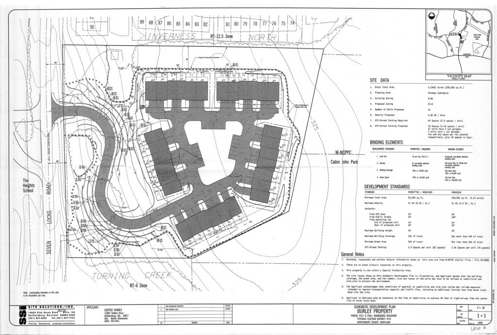
3 Figure 1 - Burley Property depicted in red SITE DESCRIPTION The subject site, known as the Burley property, (Figure 1) consists of two parcels, P361 and P417, with a total of approximately 5.24 acres. It is located on the east side of Seven Locks road, approximately 1,600 feet north of its intersection with Democracy Boulevard. It is almost rectangular in shape and has approximately 458 feet of frontage on Seven Locks road and a maximum depth of approximately 569 feet. Presently, the site is developed with a single detached dwelling unit in the southwest corner of the site. A winding steep driveway provides access from Seven Locks Road to the dwelling unit. An additional overgrown driveway is located in the northwest area of the site and leads up a steep slope to a more level area of the property close to the northern property line. With the exception of a cleared area surrounding the dwelling unit in the south west corner, the site is heavily forested, with significant large specimen trees and steep slopes. The site rises from a low point in the southwest corner at 264 feet to a high point of feet in a linear distance of 458 feet, an overall grade of 16.5 percent. The site falls from this high point towards Cabin John Regional Park to a low point of feet in the northwest corner, an overall grade of 9.4 percent. The steepest slopes are to the west with the slope from the western midpoint of the site to the 315 contour reaching 21.2 percent and from the southwest corner to the 300 contour reaching 24 percent. 3
4 Zoning History 1964 Two contiguous forested parcels (P400 and P455), abutting the subject site to the east, were acquired by M-NCPPC from the Burley estate by mutual agreement and now constitute part of Cabin John Regional Park The subject property was reclassified from the R-90 Zone to the R-T Zone by LMA F-419, permitting densities up to 12.5 dwelling units per acre At the request of the owner, and in order to avoid the increased tax burden, the previous rezoning was reversed and the property reclassified from the R-T 12.5 Zone back to the R-90 Zone by LMA F The Planning Board, in the Final Draft Potomac Subregion Master Plan, recommended acquisition of the property as an extension to Cabin John Regional Park. The owner objected and the County Council disapproved the Planning Board recommendation The owner filed an application for the R-T 8 Zone, with a schematic development plan (SDP) for 30 units (reduced from original 34). Citing environmental concerns and the absence of concept approval for stormwater management, planning staff recommended deferral/denial, and the owner requested deferral A contract purchaser of the Property filed a Local Map Amendment application (G-809) for the R-T 8 Zone with a schematic development plan for 32 units The application was amended to depict 31 units (Attachment A). The Planning Board unanimously recommended approval, subject to revision of the number, size and layout of the units at subdivision and site plan to protect the environment. The Board agreed that the schematic development plan was compatible with adjacent development in terms of unit type, density and setbacks, but indicated concern regarding preservation of natural features, erosion control and stormwater management. The Board indicated that the number of units might need to be reduced at site plan, pending a level of engineering detail that was not available at the schematic plan stage The County Council enacted a legislative change, reducing the threshold for Moderately Priced Dwelling Units (MPDUs) from 35 to 20 units. The Hearing Examiner concluded that the Property would be appropriate for RT zoning but recommended that the applicant further address stormwater management and traffic concerns. The Council permitted the applicant to withdraw the application, without prejudice. Thus, the property remains in the R-90 zone A new contract purchaser filed a pre-application concept plan under the R-90 Zone. As the G-809 case in 2006 was the last time the property was examined in detail, staff preparing this report leaned heavily on the Hearing Examiner s findings in that case. RELATIONSHIP TO NEIGHBORHOOD The Property is zoned R-90. (Figure 2) The Plan proposes the development of the 5.24 acre tract of land (gross tract area is 5.41 acres) with 23 townhouse dwelling units (19 market rate and 4 Moderately Priced Dwelling Units) at a density of 4.39 units per acre. The Property immediately abuts a series of townhouse developments, (Figure 3) as follows: North: Inverness North Zone RT acres 122 units Density 10.8 per acre Scotland Zone RT acres 100 units Density 11.1 per acre Bells Mill Spring Zone RT acres 48 units Density 11.7 per acre South: Turning Creek Zone RT acres 18 units Density 6.0 per acre 4


5 To the east of the site is the Cabin John Regional Park, and directly across Seven Locks Road to the west is a private educational institution, the Heights School zoned R-90. South and west of the Heights School, the properties are zoned R-90 and developed with single-family detached dwelling units. North of the Heights School, the property is zoned R-90 and developed with the Inverness Forest subdivision, consisting of single family and townhouse units. Figure 2 Zoning 5

6 Figure 3 - Density 6
7 The application depicts a general representation of the contemplated layout of 23 units. (Figures 4, 5 and 6) The project is proposed to be developed under Section 59-C-1.6 of the Zoning Ordinance, Development including Moderately Priced Dwelling Units. Under this section, townhouses are permitted in the R-90 zone. The application proposes 19 market lots and volunteers 4 MPDUs (15 percent) for a density of 4.39 dwelling units/acre, which is the maximum number of dwelling units per acre of usable area in the R-90 Zone. The density is below the townhouse densities of the adjacent properties (see above) and significantly below that previously approved by a prior LMA or thereafter proposed for the Property (see zoning history). The application proposes the minimum lot size of 1,500 square feet for townhouses, meets the maximum building height permitted, and exceeds the minimum parking and green area requirements. 7

8 Figure 4 - Pre-Preliminary Plan 8

9 Figure 5 - Rendering 9
10 Figure 6 - Sections 10
11 ANALYSIS AND FINDINGS Master Plan Compliance The Project meets the relevant recommendations contained in the Master Plan for the Property. It is consistent with the Plan s recommendation of residential land use, and consistent with its zoning recommendation, which calls for retaining the R-90 Zone. The Project also provides affordable housing, a goal specifically recommended on page 38 of the Master Plan: One goal of this Master Plan is to retain and expand the supply of affordable housing in the Potomac Subregion. The Plan supports the Montgomery County Housing Policy and endorses opportunities that will result in meeting the Policy s objectives. The Plan also supports measures to provide affordable housing in the Subregion and recommends continuing the seek ways to fill this need. The proposed development will provide for 15% MPDU s or a total of 4 additional affordable housing units in an area of Montgomery County that is currently under served, and that otherwise would not be provided under standard development for single family detached dwelling units. Compliance with the Zoning Ordinance This application has been reviewed for compliance with the Montgomery County Code, Chapter 59 ( Zoning Ordinance ). The proposed lots meet the dimensional requirements for area, frontage, and width for townhouses in the R-90 zone. Setbacks for townhouse developments with MPDUs are typically determined at site plan. In the R-90 zone, the Zoning Ordinance states that the maximum number of one-family attached dwelling units, semidetached dwelling units or townhouses allowed in a subdivision is 50% of the total units. Section 59-C Footnote 1 states: However, the Planning Board may approve a development in which up to 100% of the total number of units are one-family attached dwelling units, one-family semidetached dwelling units, or townhouses upon a finding that a (1) proposed development is more desirable from an environmental perspective than development that would result from adherence to these percentage limits, or (2) limits on development at that site would not allow the applicant to achieve MPDUs under Chapter 25A on-site. The Board also must find that any dwelling unit type above the standard percentage allowed must achieve not less than the same level of compatibility as would exist if the development were constructed using the standard percentage of that type of dwelling unit and that any development that exceeds the maximum percentage of allowable dwelling unit types must be compatible with adjacent existing and approved development. Section 59-C (Special Optional Method of Development Requirements for MPDU Projects with 20 or fewer dwelling units) allows an applicant proposing 20 or fewer dwelling units to voluntarily provide MPDUs in such a development. An applicant who voluntarily builds at least 12.5 percent MPDUs in a development with 20 or fewer dwelling units may use the optional method development standards of Sec. 29-C-1.62, except: (1) any perimeter lot that is adjacent, abutting, or confronting one or more existing one-family detached dwellings must conform to the lot area and yard requirements of the standard method of development; (2) the MPDU buildings must be similar in size and height to the market rate dwellings in that 11
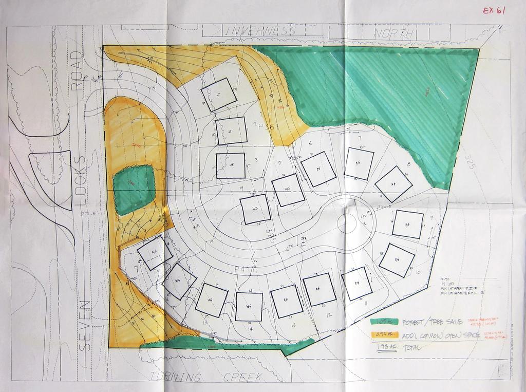
12 development, and (3) the maximum percentage of townhouses must not exceed 40% of the total residential dwellings in that development; however, the Planning Board may approve a development in which up to 100 percent of the units consist of townhouses, if the Board finds that the increased use of townhouses is more desirable for environmental reasons and the increased use of townhouses is compatible with adjacent development. The Application satisfies the provisions of the Zoning Ordinance under these sections for the following reasons: Environmental rationale 100% townhouses will preserve a greater number of specimen trees and allow the Applicant to save the forest conservation threshold of twenty (20) percent of the property (1.05 acres) on site. By way of comparison, Exhibits 61 for LMA G-809 (Attachment B) depicted an illustrative layout for 17 single family detached lots at a minimum lot size of 5,000 square feet. The green space areas depicted were as follows: Exhibit 61 Total 1.05 acres forest* 0.93 acres open space 1.98 acres (* Note - the forest save areas depicted would not meet today s standards for minimum width of 50 feet or area (10,000 square feet) and combinations of unit types were not depicted.) Standard R-90 development would require a larger impact to the site and existing forest due to the requirements and design standards for public road access. Although a private road would have the same width and area of pavement as a public road, setbacks would be measured from the right-of-way for standard development. The concept plan depicts 3.69 acres of combined forest conservation area and green space. A 100 percent townhouse layout would thus provide more significant open space than would occur if the Property were site planned for single family dwelling units with private yards. (Attachment B) (Staff notes that impervious surface area comparisons are difficult without reviewing alternative site plans.) Compatibility There are no single family detached dwellings adjacent to the proposed development. All adjacent areas are either parkland or existing townhouse developments. Thus, the first clause of the section 59-C is not applicable. The proposed development with 100% townhouses will be compatible with the abutting Inverness North townhouse development to the north and the Turning Creek townhouse development to the south. It will also be significantly less dense than both of its neighbors. It will be an appropriate use of the property and continue the existing townhouse residential character along the east side of Seven Locks Road. MPDUs Section 59-C Footnote 1 of the Zoning Ordinance states: The Planning Board may approve a development in which up to 100% of the total number of units are one-family attached dwelling units, one-family semidetached dwelling units, or 12
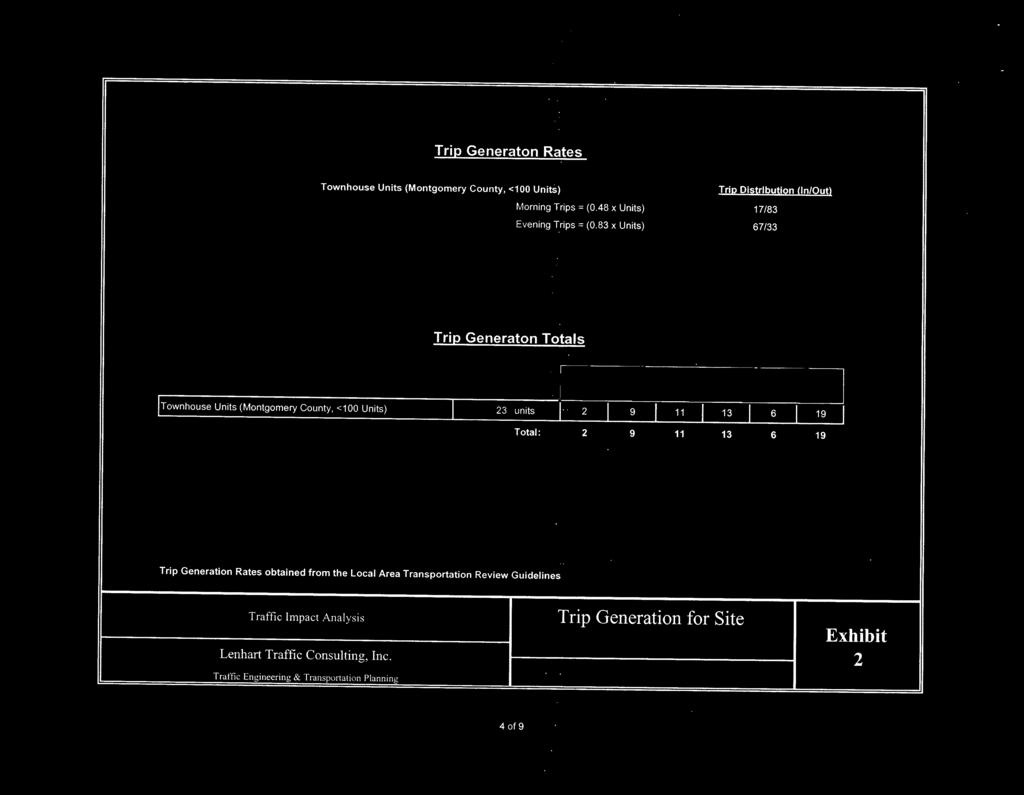
13 townhouses upon a finding that or (2) limits on development at that site would not allow the applicant to achieve MPDUs under Chapter 25A on site. The limits on development at the Burley property (size, steep grades, forest conservation, stormwater management) together with the history of the site suggest strongly that standard R- 90 development would not generate sufficient dwelling units to reach the threshold for MPDUs. Despite this footnote, applicants who volunteer MPDUs still have to meet the requirement of Section 59-C that increased use of townhouses is more desirable for environmental reasons. The application text states that the proposed MPDU units will be similar in width, appearance, height (3 story), and unit type (front load garage) as the market rate units. The text does not comport with the concept plan, which depicts the 4 units as narrower than the market units. This item would need to be addressed at preliminary plan stage. Adequate Public Facilities Roads As detailed in Council Resolution , Subdivision Staging Policy applies to any application for a Preliminary Plan of Subdivision filed on or after January 1, The Subdivision Staging Policy establishes the Local Area Transportation Review (LATR) and Transportation Policy Area Review (TPAR) Guidelines. The Guidelines require a Traffic Statement to determine the applicability and Status of LATR and TPAR requirements as they apply to the project. The Applicant provided a Traffic Statement prepared by Lenhart Traffic Consulting, Inc., (Attachment C). The Traffic Statement states that the projected trip generation for the project is based on the rates for townhouse units obtained from the LATR Guidelines, and that the facility will generate eleven (11) trips in the morning peak hour and nineteen (19) in the evening peak hour. The project is thus not subject to LATR because it would generate less than 30 peak hour trips. The project is located in the Potomac Policy Area which is exempt from the Roadway Test, but is deemed inadequate under the Transit Test. The TPAR Transportation Mitigation Payment is equal to 25% of the General District transportation impact tax for the subdivision. The new Development Impact Tax rate for single family attached dwellings for July 1, 2013 through June 30, 2015 is $11,050 per dwelling unit. TPAR will apply if and when a Preliminary Plan is filed for the project. MCDOT will determine improvements to the public right-of-way at the preliminary plan stage. At a minimum, dedication of right-of-way in accordance with the Master Plan for the arterial Seven Locks Road will be required, together with storm drain capacity and impact analysis and sight distance evaluation. Potential improvements include curb and gutter, enclosed storm drainage, concrete sidewalk, street trees, street lights, removal of existing driveway aprons, utility relocations, and upgrade to an existing crosswalk and RideOn bus facility. It is therefore not possible at this stage to determine from the concept plan application that transportation public facilities are adequate. 13
14 Schools The Property is in the Churchill School Cluster. According to the County Council Adopted FY 2013 Capital Budget and FY Capital Improvements Program, the Subdivision Staging Policy Results of School Test for FY 2013 have deemed capacity as adequate for the Cluster at all levels, elementary, middle and high school. Other Public Facilities and Services Public water and sewer and other public utilities are available to and currently serve the Property. ENVIRONMENT Forest conservation Both forest conservation and stormwater management have historically been significant issues pertaining to this property. Although the property is heavily forested, the County Council decided not to have the Potomac Master Plan recommend that it be acquired for park purposes. In LMA G-809, the Hearing Examiner stated in his Report (page 28): We have to assume that it may be developed with residential units even under the present R-90 Zone, and that would also result in destruction of forest. It is not clear from this record that the proposed townhouse development under the R-T 8 Zone would cause significantly more destruction than a detached house development under the R-90 zone. Given the Council s determination not to require preservation of this property as parkland, the Hearing Examiner finds that rezoning to the R-T 8 Zone would not cause an inappropriate loss of forest. It should be noted that the application before the Hearing Examiner was for 31 townhouse units and that the present concept plan is for 23 units. The Applicant has received approval to a Natural Resources Inventory/Forest Stand Delineation prepared for the Property. (Figure 7) A Preliminary Forest Conservation Plan is required with a Preliminary Plan of Subdivision application. Water quality and quantity The Hearing Examiner noted that the thorniest policy issue in the G-809 case (Page 28) involved the possible impact on the environment from inadequately controlled stormwater runoff. As stated by the Planning Board: the Planning Board agreed that the schematic development plan was compatible with adjacent development in terms of unit type, density, and setbacks, but indicated concern regarding preservation of natural features and erosion control, topics highlighted by neighboring citizens in their testimony. During discussion, the Planning Board agreed with staff that the indicated layout of the development was not a binding element and, in the event of the application obtaining the approval of the District Council, the layout must be revised during the preliminary plan and site plan process to meet environmental requirements. Because of the steep slopes and natural features of this site, proposed site grades, slope maintenance, stormwater management facilities, drainage 14
15 swales, access to the rear of several properties, proposed landscaping, and protection of critical root zones will need to be closely scrutinized at later stages of the development process. Some or all of the units may need to be reduced in size or the number of units cut to meet all site plan requirements, pending a level of engineering detail not available at the schematic development stage. Many of these comments are pertinent today regarding the present concept plan. But there are several significant differences: 1. The number of proposed units today is 23, not 31 as in G-809. This will provide a more compact development footprint. Sec of the Subdivision Regulations empowers the Planning Board to: Restrict subdivision of any land which it finds to be unsafe for development because of possible flooding or erosive stream action, soils with structural limitations, un-stabilized slope or fill, or similar environmental or topographical conditions. 2. In 2006, MCDPS gave the applicant a total waiver of all stream channel protection (i.e. water quantity controls). The current applicant elected to submit a Stormwater Management Concept Plan (Figure 8) to the Water Resources Section of the Montgomery County Department of Permitting Services as part of this application. The Concept Plan proposes to meet required stormwater management goals via micro-bioretention and dry wells. The concept has been deemed acceptable by MPDPS, (Attachment D) and does not include waivers. 3. Potential increased flooding and erosion on Turning Creek land to the south was a significant issue in The current applicant has addressed this issue by proposing that the drainage area from the Subject property to the Turning Creek parcel A to the south would be reduced by ninety (90) percent from the present 0.92 acres to 0.09 acres. This would alleviate the situation pertaining today. (Figure 9) 15

16 Figure 7 - NRI/FSD 16

17 Figure 8 - Stormwater Management Concept 17

18 Figure 9 - Drainage Area 18
19 COMMUNITY OUTREACH The applicant notified adjacent and confronting property owners of the pre-preliminary plan submission, as required. The Applicant also conducted a public meeting regarding the Pre-Preliminary Plan Application on January 8, 2013 at the Seven Locks Elementary School, and has arranged another meeting at the same venue on May 16, To date, staff has had inquiries from two citizens of Inverness North, whose primary concerns related to stormwater management issues. CONCLUSION Staff recommends that the Planning Board encourage the Applicant to file a Preliminary Plan consistent with the overall concept proposed in the Application. 1. The Property has previously been zoned R-T (Albeit with much less rigorous forest conservation and stormwater management regulations.) 2. The County Council, in denying park use, indicated its wish for residential development. 3. Residential development, under the R-90 Zone, is in substantial compliance with the recommendations of the Potomac Subregion Master Plan. 4. In 2005, the Planning Board recommended a re-zoning to R-T 8, with a schematic development plan of 31 townhouses. 5. In 2006, the Hearing Examiner recommended that the R-T 8 rezoning be remanded with instructions requiring a sufficient reduction in the number of townhouses such that MCDPS could approve a stormwater management concept plan without waiving channel protection requirements. The current application, in the R-90 zone, depicts such a reduction. 6. Standard R-90 development would require a larger impact to the site and existing forest due to the requirements and design standards for public road access. 7. A development with 100 percent townhouses and MPDUs will provide some affordable housing in Potomac that would not occur via standard development. 8. The concept plan is very compatible with adjacent developments in unit type. 9. The concept plan is much less dense than adjacent developments. 10. Public facilities and services are currently adequate, with the exception of transportation facilities, where it is premature to make such a finding. 11. A preliminary plan and site plan will be necessary to determine compliance with the Subdivision Regulations and the standards of the R-90 Zone under the MPDU method of development. Attachments Attachment A Schematic development plan for 31 attached units G-809 5/27/05 Attachment B Illustrative of 17 single family cluster detached units G Attachment C Applicant s traffic statement Attachment D MCDPS Approval Letter April 30,
20
21
22 22 ATTACHMENT C
23 23 ATTACHMENT C
24 24 ATTACHMENT C
25 25 ATTACHMENT D
26 26 ATTACHMENT D
MONTGOMERY COUNTY PLANNING DEPARTMENT THE MARYLAND-NATIONAL CAPITAL PARK AND PLANNING COMMISSION
 MONTGOMERY COUNTY PLANNING DEPARTMENT THE MARYLAND-NATIONAL CAPITAL PARK AND PLANNING COMMISSION MCPB Item No. Date: 12/4/14 Preliminary Plan No. 120140200, Northwood Knolls Description Patrick Butler,
MONTGOMERY COUNTY PLANNING DEPARTMENT THE MARYLAND-NATIONAL CAPITAL PARK AND PLANNING COMMISSION
 MONTGOMERY COUNTY PLANNING DEPARTMENT THE MARYLAND-NATIONAL CAPITAL PARK AND PLANNING COMMISSION MCPB Item No.: Date: 06-21-12 The Plantations, Preliminary Plan -120090240 Benjamin Berbert, Senior Planner,
MONTGOMERY COUNTY PLANNING DEPARTMENT THE MARYLAND-NATIONAL CAPITAL PARK AND PLANNING COMMISSION
 MONTGOMERY COUNTY PLANNING DEPARTMENT THE MARYLAND-NATIONAL CAPITAL PARK AND PLANNING COMMISSION MCPB Item No. 3 Date: 01-31-13 Preliminary Plan 120090300, Boyds Highlands Calvin Nelson, Jr. Planner Coordinator,
MONTGOMERY COUNTY PLANNING DEPARTMENT THE MARYLAND-NATIONAL CAPITAL PARK AND PLANNING COMMISSION
 MONTGOMERY COUNTY PLANNING DEPARTMENT THE MARYLAND-NATIONAL CAPITAL PARK AND PLANNING COMMISSION MCPB Item No. 8 Date: 03-07-13 Sonoma, Preliminary Plan, 120130040 Melissa Williams, Senior Planner, Melissa.williams@montgomeryplanning.org,
CREEKSIDE TOWNHOMES Chevy Chase, Maryland Site Plan No Preliminary Plan No
 +1 (301) 656 5901 info@nova-habitat.com CREEKSIDE TOWNHOMES Chevy Chase, Maryland Site Plan No. 820160050 Preliminary Plan No. 120160130 Application Statement of Justification October 28, 2015 Nova-Habitat,
MONTGOMERY COUNTY PLANNING DEPARTMENT THE MARYLAND-NATIONAL CAPITAL PARK AND PLANNING COMMISSION
 MONTGOMERY COUNTY PLANNING DEPARTMENT THE MARYLAND-NATIONAL CAPITAL PARK AND PLANNING COMMISSION MCPB Item No. Date: 1-17-13 Preliminary Plan 120110180 - Parmjit & Saini Estates Katherine Holt, Senior
RECOMMENDATION: Approval subject to the following conditions:
 RECOMMENDATION: Approval subject to the following conditions: 1) Approval under this preliminary plan is limited to 2 lots for 2 dwelling units 2) The record plat must note that the preliminary plan is
MONTGOMERY COUNTY PLANNING BOARD
 APR :7 20m MONTGOMERY COUNTY PLANNING BOARD THE MARYLAND-NATIONAL CAPITAL PARK AND PLANNING COMMISSION MCPB No. 10-172 Date of Hearing: December 9, 2010 MONTGOMERY COUNTY PLANNING BOARD RESOLUTION WHEREAS,
Article Optional Method Requirements
 Article 59-6. Optional Method Requirements [DIV. 6.1. MPDU DEVELOPMENT IN RURAL RESIDENTIAL AND RESIDENTIAL ZONES Sec. 6.1.1. General Requirements... 6 2 Sec. 6.1.2. General Site and Building Type Mix...
Operating Standards Attachment to Development Application
 Planning & Development Services 2255 W Berry Ave. Littleton, CO 80120 Phone: 303-795-3748 Mon-Fri: 8am-5pm www.littletongov.org Operating Standards Attachment to Development Application 1 PLANNED DEVELOPMENT
Montgomery Village - South Valley Park: Subdivision Regulation Waiver SRW , and Site Plan No
 Montgomery Village - South Valley Park: Subdivision Regulation Waiver SRW - 201402, and Site Plan No. 820140070 12 SUBDIVISION REGULATION WAIVER RECOMMENDATION AND CONDITIONS OF APPROVAL Staff recommends
MAJOR SUBDIVISION PRELIMINARY PLAT CHECKLIST
 TOWNSHIP OF EGG HARBOR PLANNING BOARD/ZONING BOARD OF ADJUSTMENT 3515 BARGAINTOWN ROAD EGG HARBOR TOWNSHIP, NJ 08234 MAJOR SUBDIVISION PRELIMINARY PLAT CHECKLIST The following checklist is designed to
MONTGOMERY COUNTY PLANNING BOARD
 MONTGOMERY COUNTYPLANNING BOARD T H E MARYLAND-NATIONAL CAPITAL PARK A N D P L A N N I N G C O M M I S S I O N MCPB NO. 10-100 Preliminary Plan No. 120100210 Date of Hearing: July 1, 2010 MONTGOMERY COUNTY
Town of Norwich, Vermont SUBDIVISION REGULATIONS
 Town of Norwich, Vermont SUBDIVISION REGULATIONS Adopted: August 6, 2002 Amended: February 8, 2006 Prepared by Norwich Planning Commission with the assistance of: Burnt Rock Inc. A ssociates in Community
FREQUENTLY USED PLANNING & ZONING TERMS
 City Of Mustang FREQUENTLY USED PLANNING & ZONING TERMS Abut: Having property lines, street lines, or zoning district lines in common. Accessory Structure: A structure of secondary importance or function
MONTGOMERY COUNTY PLANNING DEPARTMENT THE MARYLAND-NATIONAL CAPITAL PARK AND PLANNING COMMISSION
 MONTGOMERY COUNTY PLANNING DEPARTMENT THE MARYLAND-NATIONAL CAPITAL PARK AND PLANNING COMMISSION MCPB Item No.: Date: 07-28-16 Lake Normandy Estates: Pre-Preliminary Plan No. 720160020 Ryan Sigworth AICP,
MONTGOMERY COUNTY PLANNING DEPARTMENT THE MARYLAND-NATIONAL CAPITAL PARK AND PLANNING COMMISSION
 MONTGOMERY COUNTY PLANNING DEPARTMENT THE MARYLAND-NATIONAL CAPITAL PARK AND PLANNING COMMISSION MCPB Item No. Date: 10-11-12 Subdivision Review Waiver SRW 2011001: Big Woods Road Richard Weaver, Acting
Community Development
 Land Use Petition RZ-15-010 Concurrent Variance VC-15-010-01 Date of Staff Recommendation Preparation: August 14, 2015 Date of Planning Commission Recommendation: September 1, 2015 PROJECT LOCATION: DISTRICT/SECTION/LANDLOT(S):
GROSVENOR-STRATHMORE METRO STATION MANDATORY REFERRAL APPLICATION NORTH BETHESDA, MD
 GROSVENOR-STRATHMORE METRO STATION MANDATORY REFERRAL APPLICATION NORTH BETHESDA, MD Submission by: Fivesquares JDA at Grosvenor Metro, LLC On behalf of Washington Metropolitan Area Transit Authority 1
WESTMINSTER PARK PLACE SUBDIVISION
 WESTMINSTER PARK PLACE SUBDIVISION Engineering Comments: FINAL PLAT COMMENTS (should be addressed prior to submitting the FINAL PLAT for review and/or signature by the City Engineer): A. Provide all of
ARTICLE OPTIONAL METHOD REGULATIONS
 ARTICLE 59-6. OPTIONAL METHOD REGULATIONS DIV. 6.1. MPDU DEVELOPMENT IN RURAL RESIDENTIAL AND RESIDENTIAL ZONES SEC. 6.1.1. GENERAL REQUIREMENTS... 6 2 SEC. 6.1.2. GENERAL SITE AND BUILDING T PE MIX...
-MENDOCINO COUNTY PLANNING AND BUILDING SERVICES- DIVISION OF LAND REGULATIONS TITLE 17
 ARTICLE VI -- GENERAL REGULATIONS AND PROVISIONS Sec. 17-50. Sec. 17-51 General Plan. Sec. 17-52 Lot and Block Design and Configuration. Sec. 17-53 Lot Access. Sec. 17-54 Private Roads. Sec. 17-55 Water
Charter Township of Plymouth Zoning Ordinance No. 99 Page 208 Article 21: Residential Unit Developments Amendments: ARTICLE XXI
 Charter Township of Plymouth Zoning Ordinance No. 99 Page 208 ARTICLE XXI RESIDENTIAL UNIT DEVELOPMENTS PURPOSE The purpose of the Residential Unit Development (RUD) is to permit two (2) optional methods
Community Development
 Land Use Petition RZ-16-002 Date of Staff Recommendation Preparation: April 15, 2016 (CEL) Date of Planning Commission Recommendation: May 3, 2016 PROJECT LOCATION: DISTRICT/SECTION/LANDLOT(S): ACREAGE
WESTMINSTER PARK SUBDIVISION
 WESTMINSTER PARK SUBDIVISION Engineering Comments: FINAL PLAT COMMENTS (should be addressed prior to submitting the FINAL PLAT for review and/or signature by the City Engineer): A. Provide all of the required
Cobb County Community Development Agency Zoning Division 1150 Powder Springs St. Marietta, Georgia 30064
 Cobb County Community Development Agency Zoning Division 1150 Powder Springs St. Marietta, Georgia 30064 Case # Z-63 Public Hearing Dates: PC: 11-06-18 BOC: 11-20-18 SITE BACKGROUND Applicant: Loyd Development
The following regulations shall apply in the R-E District:
 "R-E" RESIDENTIAL ESTATE DISTRICT (8/06) The following regulations shall apply in the R-E District: 1. Uses Permitted: The following uses are permitted. A Zoning Certificate may be required as provided
Staff Report: Date: Applicant: Property Identification: Acreage of Request: Current Zoning of Requested Area: Requested Action: Attached:
 Staff Report: Completed by Jeff Palmer Director of Planning & Zoning Date: November 7, 2018 Applicant: Greg Smith, Oberer Land Developer agent for Ronald Montgomery ET AL Property Identification: Frontage
DANAC Stiles Property. Preliminary Plan A
 DANAC Stiles Property Preliminary Plan 11996112A Vicinity Located in the LSC North District of the GSSC Master Plan. Adjacent Uses North: Single-family attached townhouses, R-60 zone; East: Office building,
Town of Windham. Planning Department 8 School Road Windham, ME voice fax
 Town of Windham Planning Department 8 School Road Windham, ME 04062 voice 207.894.5960 fax 207.892.1916 MEMO DATE: September 3, 2013 TO: Tony Plante, Town Manager FROM: Ben Smith, Assistant Town Planner
Chapter 22 PLANNED UNIT DEVELOPMENT.
 Chapter 22 PLANNED UNIT DEVELOPMENT. Sec. 22.1 INTENT. The use of land and the construction and use of buildings and other structures as Planned Unit Developments in Georgetown Township may be established
Initial Subdivision Applications Shall Include the Following:
 Initial Subdivision Applications Shall Include the Following: 1) Subdivision Application Form: completely filled out (12 copies) 2) Plat: The Plat must adhere to the requirements set forth in the Town
Initial Project Review
 Pierce County Department of Planning and Land Services, 2401 South 35th Street, Tacoma, WA (253) 798-7037 Initial Project Review Major Amendment to Preliminary Plat: Hawks Ridge Division 1 Application
ARTICLE III GENERAL PROCEDURES, MINOR PLANS AND FEE SCHEDULES
 ARTICLE III GENERAL PROCEDURES, MINOR PLANS AND FEE SCHEDULES 301. Prior to Submission a. Copies of this Ordinance shall be available on request, at cost, for the use of any person who desires information
JUSTIFICATION STATEMENT FOR PRELIMINARY PLAN NO Preliminary Plan Justification for Chevy Chase Lake
 I. INTRODUCTION JUSTIFICATION STATEMENT FOR PRELIMINARY PLAN NO. 120150130 Preliminary Plan Justification for Chevy Chase Lake Applicant, CC Associates LLC (the Applicant ), by its attorneys, Linowes and
MONTGOMERY COUNTY PLANNING DEPARTMENT THE MARYLAND-NATIONAL CAPITAL PARK AND PLANNING COMMISSION
 MONTGOMERY COUNTY PLANNING DEPARTMENT THE MARYLAND-NATIONAL CAPITAL PARK AND PLANNING COMMISSION MCPB Item No. 6 Date: 9-27-18 Seneca Farms, Preliminary Plan No. 120170240 Jonathan Casey, Senior Planner,
ARTICLE 8C SITE CONDOMINIUM DEVELOPMENT ORDINANCE
 ARTICLE 8C SITE CONDOMINIUM DEVELOPMENT ORDINANCE SECTION 8C.01 PURPOSE It is the purpose of this Ordinance to insure that plans for development within Oceola Township proposed under the provisions of
DEVELOPMENT STANDARDS FOR RESIDENTIAL PROJECTS RESIDENTIAL BUILDING TYPES: APPROPRIATE ZONES AND DENSITIES 2-1
 2 DEVELOPMENT STANDARDS FOR RESIDENTIAL PROJECTS RESIDENTIAL BUILDING TYPES: APPROPRIATE ZONES AND DENSITIES 2-1 This Chapter presents the development standards for residential projects. Section 2.1 discusses
Division Development Impact Review.
 Division 51-4.800. Development Impact Review. SEC. 51-4.801. PURPOSE. The general objectives of this division are to promote and protect the health, safety, and general welfare of the public through the
FINAL SUBDIVISION AND LAND DEVELOPMENT PLAN CHECKLIST. Plan Name. Applicant's Name:
 TOWNSHIP OF UPPER ST. CLAIR FINAL SUBDIVISION AND LAND DEVELOPMENT PLAN CHECKLIST Date Filed Plan Name PLC Applicant's Name: Phone Filing Date for Final Application Final Plat 114.22. FINAL APPLICATION
MONTGOMERY COUNTY PLANNING DEPARTMENT THE MARYLAND-NATIONAL CAPITAL PARK AND PLANNING COMMISSION
 MONTGOMERY COUNTY PLANNING DEPARTMENT THE MARYLAND-NATIONAL CAPITAL PARK AND PLANNING COMMISSION Wheaton Woods, Preliminary Plan No. 120160060 MCPB Item No. Date: 02-25-16 Lori Shirley, Planner Coordinator,
ZONING AMENDMENT, PLANNED UNIT DEVELOPMENT & SUBDIVISION STAFF REPORT Date: August 8, 2013
 ZONING AMENDMENT, PLANNED UNIT DEVELOPMENT & SUBDIVISION STAFF REPORT Date: August 8, 2013 NAME SUBDIVISION NAME PV-Magnolia, LLC Twelve Trees Subdivision LOCATION 2860, 2862 and 2866 Pleasant Valley Road
Staff Report: Date: Applicant: Property Identification: Acreage of Request: Current Zoning of Requested Area: Requested Action: Attached:
 Staff Report: Completed by Jeff Palmer Director of Planning & Zoning Date: November 7, 2018, Updated November 20, 2018 Applicant: Greg Smith, Oberer Land Developer agent for Ronald Montgomery ET AL Property
O-I (Office-Institutional) and AG-1(Agricultural)
 and AG-1(Agricultural)") PROPERTY INFORMATION ADDRESS 3503 and 3505 Bethany Bend DISTRICT, LAND LOTS 2/1 973 and 974 OVERLAY DISTRICT State Route 9 PETITION NUMBERS EXISTING ZONING O-I (Office-Institutional) and AG-1(Agricultural)
PROPERTY INFORMATION ADDRESS 3503 and 3505 Bethany Bend DISTRICT, LAND LOTS 2/1 973 and 974 OVERLAY DISTRICT State Route 9 PETITION NUMBERS EXISTING ZONING O-I (Office-Institutional) and AG-1(Agricultural)
HERON LANDING SUBDIVISION
 HERON LANDING SUBDIVISION Engineering Comments: Per FEMA guidelines, any development greater than 5 acres in size or subdivision 50 lots in size, requires a flood study. Width of drainage easement to be
Town of Cary, North Carolina Rezoning Staff Report 14-REZ-20 Habitat for Humanity Evans Road Town Council Meeting October 16, 2014
 Town of Cary, North Carolina Rezoning Staff Report 14-REZ-20 Habitat for Humanity Evans Road Town Council Meeting October 16, 2014 REQUEST To amend the Town of Cary Official Zoning Map by rezoning 0.53
SECTION 7000 LAND DEVELOPMENT REQUIREMENTS
 SECTION 7000 LAND DEVELOPMENT REQUIREMENTS 7000 LAND DEVELOPMENT REQUIREMENTS... 1 7001 LEGISLATIVE AUTHORITY... 1 7001.1 LAND DEVELOPMENT... 1 7001.1.1 Title 40, Idaho Code... 1 7001.1.2 Idaho Code 40-1415
Organized with a "core" curriculum (the first five modules) and "electives" (the remaining modules in the program.
 and electives (the remaining modules in the program.") Introduction Sponsored by The North Carolina Chapter - American Planning Association These materials are the result of an effort by volunteer members of the North Carolina Chapter of the American Planning
Introduction Sponsored by The North Carolina Chapter - American Planning Association These materials are the result of an effort by volunteer members of the North Carolina Chapter of the American Planning
UPPER MOUNT BETHEL TOWNSHIP NORTHAMPTON COUNTY, PENNSYLVANIA
 UPPER MOUNT BETHEL TOWNSHIP NORTHAMPTON COUNTY, PENNSYLVANIA JOINDER DEED / LOT CONSOLIDATION TOWNSHIP REVIEW PROCESS When accepting proposed Joinder Deeds / Lot Consolidations, review the Joinder Deed
SITE PLAN REVIEW PROCEDURES SECTION DEVELOPMENTS REQUIRING SITE PLAN APPROVAL
 SECTION 22.01 PURPOSE ARTICLE XXII PROCEDURES The purpose of this Article is to establish uniform requirements of procedure for all developments in the Township. Certain specific types of minor development
PIN , Part 1, Plan SR-713 in Lot 2, Concession 5, Township of McKim (1096 Dublin Street, Sudbury)
") STAFF REPORT Applicant: Dalron Construction Limited Location: PIN 02124-0103, Part 1, Plan SR-713 in Lot 2, Concession 5, Township of McKim (1096 Dublin Street, Sudbury) Official Plan and Zoning By-law:
STAFF REPORT Applicant: Dalron Construction Limited Location: PIN 02124-0103, Part 1, Plan SR-713 in Lot 2, Concession 5, Township of McKim (1096 Dublin Street, Sudbury) Official Plan and Zoning By-law:
Amendment to the Zoning and Subdivision Ordinances; Consider Repeal Cluster Development Standards
 2 Board of Supervisors Meg Bohmke, Chairman Gary F. Snellings, Vice Chairman Jack R. Cavalier Thomas C. Coen L. Mark Dudenhefer Wendy E. Maurer Cindy C. Shelton February 28, 2018 Thomas C. Foley County
PLANNED UNIT DEVELOPMENT & SUBDIVISION STAFF REPORT Date: July 20, 2017
 PLANNED UNIT DEVELOPMENT & SUBDIVISION STAFF REPORT Date: July 20, 2017 DEVELOPMENT NAME SUBDIVISION NAME LOCATION Rangeline Crossing III Subdivision Rangeline Crossing III Subdivision 5289 Halls Mill
MONTGOMERY COUNTY PLANNING BOARD
 MONTGOMERY COUNTY PLANNING BOARD T H E MARYLAND-NATIONAL CAPITAL PARK A N D P L A N N I N G C O M M I S S I O N MCPB NO. 10-144 Hearing Date: September 30, 2010 MONTGOMERY COUNTY PLANNING BOARD RESOLUTION
ZONING AMENDMENT & SUBDIVISION STAFF REPORT Date: November 3, 2016
 ZONING AMENDMENT & SUBDIVISION STAFF REPORT Date: November 3, 2016 APPLICANT NAME SUBDIVISION NAME David Shumer 5955 Airport Subdivision CITY COUNCIL DISTRICT District 6 5955 Airport Boulevard, 754 Linlen
STATE OF ALABAMA SHELBY COUNTY
 STATE OF ALABAMA SHELBY COUNTY Members Present: Members Absent: Staff Present: SHELBY COUNTY PLANNING COMMISSION MINUTES Regular Meeting March 6, 2017 6:00 PM Michael O Kelley, Chairman; Jim Davis, Vice
ARTICLE 3 DEFINITIONS
 Sections: 3-1 Rules of Construction 3-2 Definitions ARTICLE 3 DEFINITIONS SECTION 3-1 RULES OF CONSTRUCTION 3-101. a. The language set forth in these regulations shall be interpreted in accordance with
Parkland-Spanaway-Midland LUAC - Agenda
 1. 6:30 P.M. Parkland-Spanaway-Midland LUAC - Agenda Documents: 8 2 17 PSMAC Agenda.pdf 2. Parkland-Spanaway-Midland LUAC Initial Project Review Documents: Lincoln Court PP IPR PSMAC-RJ.pdf Department
CHARLES CITY COUNTY SITE PLAN ORDINANCE. This Ordinance shall be known as the Charles City County Site Plan Ordinance.
 CHARLES CITY COUNTY SITE PLAN ORDINANCE Section 1. Title This Ordinance shall be known as the Charles City County Site Plan Ordinance. Section 2. Authority. This Ordinance is enacted pursuant to the authority
DISTRICT COUNCIL FOR PRINCE GEORGE S COUNTY, MARYLAND OFFICE OF ZONING HEARING EXAMINER SPECIAL EXCEPTION 4658 DECISION
 DISTRICT COUNCIL FOR PRINCE GEORGE S COUNTY, MARYLAND OFFICE OF ZONING HEARING EXAMINER SPECIAL EXCEPTION 4658 DECISION Application: Three Chair Barber Shop Applicants: Danta L. & Felicia B. Wright/Fort
Open Space Model Ordinance
 Open Space Model Ordinance Section I. Background Open space development has numerous environmental and community benefits, including: 1) Reduces the impervious cover in a development. Impervious cover
Article Floating Zone Requirements
 Division 5.1. In General Article 59-5. Floating Zone Requirements Section 5.1.1. Zone Categories There are 4 categories of Floating zones: A. Residential Floating zones (Division 5.2); B. Commercial/Residential
MONTGOMERY COUNTY PLANNING DEPARTMENT THE MARYLAND-NATIONAL CAPITAL PARK AND PLANNING COMMISSION
 MONTGOMERY COUNTY PLANNING DEPARTMENT THE MARYLAND-NATIONAL CAPITAL PARK AND PLANNING COMMISSION St. Andrews Episcopal School, Forest Conservation Plan Amendment, CBA 1389C (In response to violation) MCPB
KASSON TOWNSHIP PRIVATE ACCESS ROAD ORDINANCE ORDINANCE NO (EFFECTIVE: MAY 12, 2007)
") KASSON TOWNSHIP PRIVATE ACCESS ROAD ORDINANCE ORDINANCE NO. 2007-01 (EFFECTIVE: MAY 12, 2007) An ordinance providing for the standards and specifications incident to the development of Private Motor Vehicle
KASSON TOWNSHIP PRIVATE ACCESS ROAD ORDINANCE ORDINANCE NO. 2007-01 (EFFECTIVE: MAY 12, 2007) An ordinance providing for the standards and specifications incident to the development of Private Motor Vehicle
PLANNED UNIT DEVELOPMENTS (Ordinance No.: 3036, 12/3/07; Repealed & Replaced by Ordinance No.: 4166, 10/15/12)
") 159.62 PLANNED UNIT DEVELOPMENTS (Ordinance No.: 3036, 12/3/07; Repealed & Replaced by Ordinance No.: 4166, 10/15/12) A. PURPOSE 1. General. The Planned Unit Development (PUD) approach provides the flexibility
159.62 PLANNED UNIT DEVELOPMENTS (Ordinance No.: 3036, 12/3/07; Repealed & Replaced by Ordinance No.: 4166, 10/15/12) A. PURPOSE 1. General. The Planned Unit Development (PUD) approach provides the flexibility
Washington County, Minnesota Ordinances
 Washington County, Minnesota Ordinances Ordinance No. 153 Text Amendment to the Washington County Development Code - Chapter One, Section 2 and Chapter Two, Part 1, Part 2, Part 3, of the Development Code
ARTICLE 1 GENERAL PROVISIONS
 ARTICLE 1 GENERAL PROVISIONS SECTION 100 TITLE This Ordinance shall be known and cited as the "Rice Township Subdivision and Land Development Ordinance." SECTION 101 AUTHORITY Rice Township is empowered
A.3. ARTICLE 7 PLAN REQUIREMENTS FOR MINOR SUBDIVISION AND/OR LAND DEVELOPMENT
 700. 701.A.3. ARTICLE 7 PLAN REQUIREMENTS FOR MINOR SUBDIVISION AND/OR LAND DEVELOPMENT SECTION 700 PURPOSE The purpose of this Article is to set forth a streamlined set of Plan Requirements for minor
MONTGOMERY COUNTY PLANNING DEPARTMENT THE MARYLAND-NATIONAL CAPITAL PARK AND PLANNING COMMISSION
 MONTGOMERY COUNTY PLANNING DEPARTMENT THE MARYLAND-NATIONAL CAPITAL PARK AND PLANNING COMMISSION MCPB Item No. Date: 10-03-13 Preliminary Plan Amendment No. 11999034B Alvermar Woods, Lot 17 (In Response
Medical Marijuana Special Exception Use Information
 Medical Marijuana Special Exception Use Information The Special Exception Use information below is a modified version of the Unified Development Code. It clarifies the current section 5:104 Special Exceptions
SECTION 4: PRELIMINARY PLAT
 SECTION 4: PRELIMINARY PLAT After the completion of the sketch plan process, if submitted, the owner or developer shall file with the City an application for preliminary plat. The preliminary plat stage
Bowie Marketplace Residential Detailed Site Plan Statement of Justification January 13, 2017 Revised February 2, 1017
 Bowie Marketplace Residential Detailed Site Plan Statement of Justification January 13, 2017 Revised February 2, 1017 Submitted on behalf of: BE Bowie LLC 5410 Edson Lane, Suite 220 Rockville, MD 20852
MONTGOMERY COUNTY PLANNING DEPARTMENT THE MARYLAND-NATIONAL CAPITAL PARK AND PLANNING COMMISSION
 MONTGOMERY COUNTY PLANNING DEPARTMENT THE MARYLAND-NATIONAL CAPITAL PARK AND PLANNING COMMISSION MCPB Item No. Date: 12/6/12 Limited Site Plan Amendment, 82000018D, DANAC Stiles Property, Lot 6 of Block
THE COUNTY BOARD OF SUPERVISORS OF THE COUNTY OF DOUGLAS DOES ORDAIN AS FOLLOWS:
 8.1 SUBDIVISION CONTROL ORDINANCE THE COUNTY BOARD OF SUPERVISORS OF THE COUNTY OF DOUGLAS DOES ORDAIN AS FOLLOWS: SECTION I. GENERAL INTERPRETATION This ordinance shall not repeal, impair or modify private
Wampus Mills Subdivision, Tree Removal Permit and Steep Slope Permit Approvals [#14-103]
![Wampus Mills Subdivision, Tree Removal Permit and Steep Slope Permit Approvals [#14-103]](/thumbs/95/122755150.jpg "Wampus Mills Subdivision, Tree Removal Permit and Steep Slope Permit Approvals [#14-103]") TOWN OF NORTH CASTLE WESTCHESTER COUNTY 17 Bedford Road Armonk, New York 10504-1898 PLANNING DEPARTMENT Adam R. Kaufman, AICP Director of Planning Telephone: (914) 273-3542 Fax: (914) 273-3554 www.northcastleny.com
TOWN OF NORTH CASTLE WESTCHESTER COUNTY 17 Bedford Road Armonk, New York 10504-1898 PLANNING DEPARTMENT Adam R. Kaufman, AICP Director of Planning Telephone: (914) 273-3542 Fax: (914) 273-3554 www.northcastleny.com
MONTGOMERY COUNTY PLANNING DEPARTMENT THE MARYLAND-NATIONAL CAPITAL PARK AND PLANNING COMMISSION
 MONTGOMERY COUNTY PLANNING DEPARTMENT THE MARYLAND-NATIONAL CAPITAL PARK AND PLANNING COMMISSION MCPB Item No.: 10 Date: 06-28-18 Park Potomac: Site Plan Amendment No. 82004015N Benjamin Berbert, Planner
ZONING AMENDMENT & SUBDIVISION STAFF REPORT Date: July 9, 2015
 ZONING AMENDMENT & SUBDIVISION STAFF REPORT Date: July 9, 2015 APPLICANT NAME 2513 Dauphin Street, Inc. SUBDIVISION NAME Audubon Place Extension No. 3, Resubdivision of Lots 1-5 LOCATION 2513 Dauphin Street
DAUPHIN CREEK ESTATES SUBDIVISION
 # 12 SUB-000076-2017 DAUPHIN CREEK ESTATES SUBDIVISION Engineering Comments: FINAL PLAT COMMENTS (should be addressed prior to submitting the FINAL PLAT for review and/or signature by the City Engineer):
Appendix J - Planned Unit Development (PUD)
") Appendix J - Planned Unit Development (PUD) Intent and Purpose The purpose of the PUD is: 1. To provide development that is consistent with the Comprehensive Land Use Plan and promote the goals and objectives
Appendix J - Planned Unit Development (PUD) Intent and Purpose The purpose of the PUD is: 1. To provide development that is consistent with the Comprehensive Land Use Plan and promote the goals and objectives
Kitsap County Department of Community Development. Staff Report and Administrative Decision
 Kitsap County Department of Community Development Report Date: Staff Report and Administrative Decision Application Complete Date: March 19, 2018 Application Submittal Date: March 19, 2018 To: Seth Hanson,
MONTGOMERY COUNTY PLANNING DEPARTMENT THE MARYLAND-NATIONAL CAPITAL PARK AND PLANNING COMMISSION
 MONTGOMERY COUNTY PLANNING DEPARTMENT THE MARYLAND-NATIONAL CAPITAL PARK AND PLANNING COMMISSION MCPB Item No. xxxxx Date: 6-7-12 Hoyt Property, Preliminary/Site Plan, 120120140/820120070 Tina Schneider,
E L M E R B O R O U G H L A N D U S E B O A R D APPLICATION COVER SHEET (to be completed for all applications and appeals)
") E L M E R B O R O U G H L A N D U S E B O A R D APPLICATION COVER SHEET (to be completed for all applications and appeals) 1. Name(s): 2. Address: 3. Telephone Number(s): 4. E-mail: 5. Owner Name(s) (if
E L M E R B O R O U G H L A N D U S E B O A R D APPLICATION COVER SHEET (to be completed for all applications and appeals) 1. Name(s): 2. Address: 3. Telephone Number(s): 4. E-mail: 5. Owner Name(s) (if
ARTICLE 15 - PLANNED UNIT DEVELOPMENT
 Section 15.1 - Intent. ARTICLE 15 - PLANNED UNIT DEVELOPMENT A PUD, or Planned Unit Development, is not a District per se, but rather a set of standards that may be applied to a development type. The Planned
A. ARTICLE 16 - STEEP SLOPE CONSERVATION DISTRICT
 1600. 1601.A. ARTICLE 16 - STEEP SLOPE CONSERVATION DISTRICT SECTION 1600 PURPOSE The purpose of this Article is to expand upon the Community Development Objectives associated with environmental protection
M-43 CORRIDOR OVERLAY ZONE
 ARTICLE 26.00 M-43 CORRIDOR OVERLAY ZONE Section 26.01 Findings A primary function of the M-43 state highway is to move traffic through the Township and to points beyond. As the primary east-west arterial
MONTGOMERY COUNTY PLANNING DEPARTMENT THE MARYLAND-NATIONAL CAPITAL PARK AND PLANNING COMMISSION
 MONTGOMERY COUNTY PLANNING DEPARTMENT THE MARYLAND-NATIONAL CAPITAL PARK AND PLANNING COMMISSION MCPB Item No. Date: 10-1-15 Chick-fil-A Olney: Preliminary Plan No. 120150180 and Site Plan No. 820150100
ARTICLE 5 GENERAL REQUIREMENTS
 5.1 SUITABILITY OF THE LAND ARTICLE 5 GENERAL REQUIREMENTS 5.1.1 Land subject to flooding, improper drainage or erosion, and land deemed to be unsuitable for development due to steep slope, unsuitable
ARTICLE 23 CONDOMINIUM STANDARDS
 ARTICLE 23 CONDOMINIUM STANDARDS Section 23.01 Intent. The intent of this Article is to provide regulatory standards for condominiums and site condominiums similar to those required for projects developed
Cover Letter with Narrative Statement
 Cover Letter with Narrative Statement March 31, 2017 rev July 27, 2017 RE: Rushton Pointe Residential Planned Unit Development Application for Public Hearing for RPUD Rezone PL2015 000 0306 Mr. Eric Johnson,
Staff Report for Council Public Meeting
 Agenda Item 3.3 Staff Report for Council Public Meeting Date of Meeting: September 27, 2017 Report Number: SRPRS.17.134 Department: Division: Subject: Planning and Regulatory Services Development Planning
Salem Township Zoning Ordinance Page 50-1 ARTICLE 50.0: PUD PLANNED UNIT DEVELOPMENT
 Salem Township Zoning Ordinance Page 50-1 ARTICLE 50.0 PLANNED UNIT DEVELOPMENT Section 50.01 Purpose The provisions of this Article provide enabling authority and standards for the submission, review,
MONTGOMERY COUNTY PLANNING DEPARTMENT
 MONTGOMERY COUNTY PLANNING DEPARTMENT THE MARYLAND-NATIONAL CAPITAL PARK AND PLANNING COMMISSION Forest Conservation Law Amendments - Modifications MCPB Item No. 7 Date: 5/24/2018 SUMMARY Mark Pfefferle,
Zoning Code Training MONTGOMERY COUNTY PLANNING DEPARTMENT. Maryland-National Capital Park and Planning Commission
 Zoning Code Training Highlights New code was adopted on March 5 & DMA was adopted on July 15. Both become effective on October 30. ZTA 14-09 was approved Sept 30 and updates, clarifies, and corrects errors
PLANNED UNIT DEVELOPMENT & SUBDIVISION STAFF REPORT August 18, 2016
 PLANNED UNIT DEVELOPMENT & SUBDIVISION STAFF REPORT August 18, 2016 DEVELOPMENT NAME SUBDIVISION NAME Mullinax Ford Subdivision Mullinax Ford Subdivision LOCATION CITY COUNCIL DISTRICT District 6 Southeast
PLANNED UNIT DEVELOPMENT & SUBDIVISION STAFF REPORT Date: April 18, 2019
 PLANNED UNIT DEVELOPMENT & SUBDIVISION STAFF REPORT Date: April 18, 2019 DEVELOPMENT NAME SUBDIVISION NAME Springhill Village Subdivision Springhill Village Subdivision LOCATION 4350, 4354, 4356, 4358,
ARTICLE V PRELIMINARY PLAN SUBMISSION
 ARTICLE V PRELIMINARY PLAN SUBMISSION 501. Plan Requirements a. On or before the 25 th day of the month prior to a regularly scheduled meeting of the Planning Commission, the applicant shall submit two
2. Rezone a portion of the lot from R2 (Small Lot Residential) to RD2 (Duplex: Housing Lane).
 to RD2 (Duplex: Housing Lane).") Public Notice September 6, 2018 Subject Property Subject Property: 337 Hastings Ave Lot 24, District Lot 1, Group 7, Similkameen Division Yale (Formerly Yale-Lytton) District, Plan 932 Application: The
Public Notice September 6, 2018 Subject Property Subject Property: 337 Hastings Ave Lot 24, District Lot 1, Group 7, Similkameen Division Yale (Formerly Yale-Lytton) District, Plan 932 Application: The
7-l MoNtcoupnv CouNtv PreNNrNc Boeno,I 'tne ITaRYLAND-NATIoNAL CAPITAL PARI< AND PLANNING con{n{ission
 7-l MoNtcoupnv CouNtv PreNNrNc Boeno,I 'tne ITaRYLAND-NATIoNAL CAPITAL PARI< AND PLANNING con{n{ission MCPB No. 16-023 Preliminary Plan No. '120160110 Date of Hearing: March 3, 2016 ltar 17 frft, RESOLUTlON
R E S O L U T I O N. a. Remove Table B from the plan.
 R E S O L U T I O N WHEREAS, Werrlein Property is the owner of a 0.3902-acre parcel of land in the 5th Election District of Prince George s County, Maryland, being zoned One-Family Detached Residential
9. REZONING NO Vicinity of the northwest corner of 143 rd Street and Metcalf Avenue
 9. REZONING NO. 2002-15 Vicinity of the northwest corner of 143 rd Street and Metcalf Avenue 1. APPLICANT: Andrew Schlagel is the applicant for this request. 2. REQUESTED ACTION: The applicant is requesting