MONTGOMERY COUNTY PLANNING DEPARTMENT THE MARYLAND-NATIONAL CAPITAL PARK AND PLANNING COMMISSION
|
|
|
- Johnathan Thomas
- 5 years ago
- Views:
Transcription
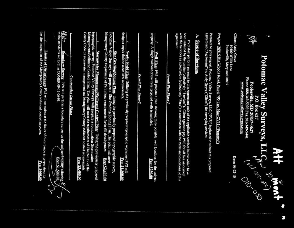
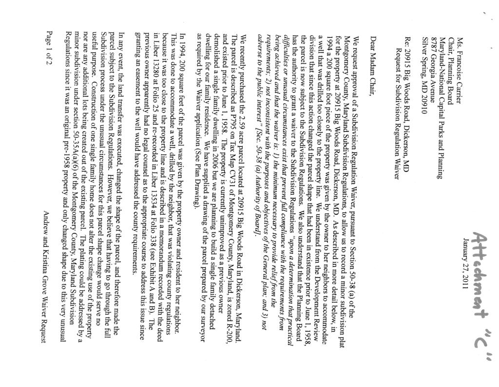
1 MONTGOMERY COUNTY PLANNING DEPARTMENT THE MARYLAND-NATIONAL CAPITAL PARK AND PLANNING COMMISSION MCPB Item No. Date: Subdivision Review Waiver SRW : Big Woods Road Richard Weaver, Acting Supervisor, Area 3, (301) John Carter, Chief, Area 3, (301) Description Completed: Subdivision Review Waiver SRW : Big Woods Road A request for a waiver under Section to allow an unplatted parcel created after June 1, 1958 to proceed under the minor subdivision process, located at Big Woods Road, 2.5 acres, R-200 Zone, Master Plan for the Preservation of Agriculture and Rural Open Space Staff Recommendation: Approval, with conditions Applicant: Andrew Grove Submission Date: March 31, 2011 Review Basis: Chapter 50 (Sec (a)(1)) Summary Section 50-35A(a)(1) Minor Subdivisions recognizes that while parcels created by a deed recorded prior to June 1, 1958, and that have remained unchanged in size or shape since that date, are exempt from the platting requirements, an owner may voluntarily plat such an exempt parcel under the minor subdivision process i.e., without preliminary plan approval. The Subject Property was such an exempt parcel, however, in July, 1995 a former owner deeded away 200 square feet of the 2.59 acre parcel to an adjacent property owner. The Applicant cites unusual circumstances (erroneous government document) that have caused a significant delay in securing building permits and seeks a waiver that will allow the property to be platted under the minor subdivision process. 1
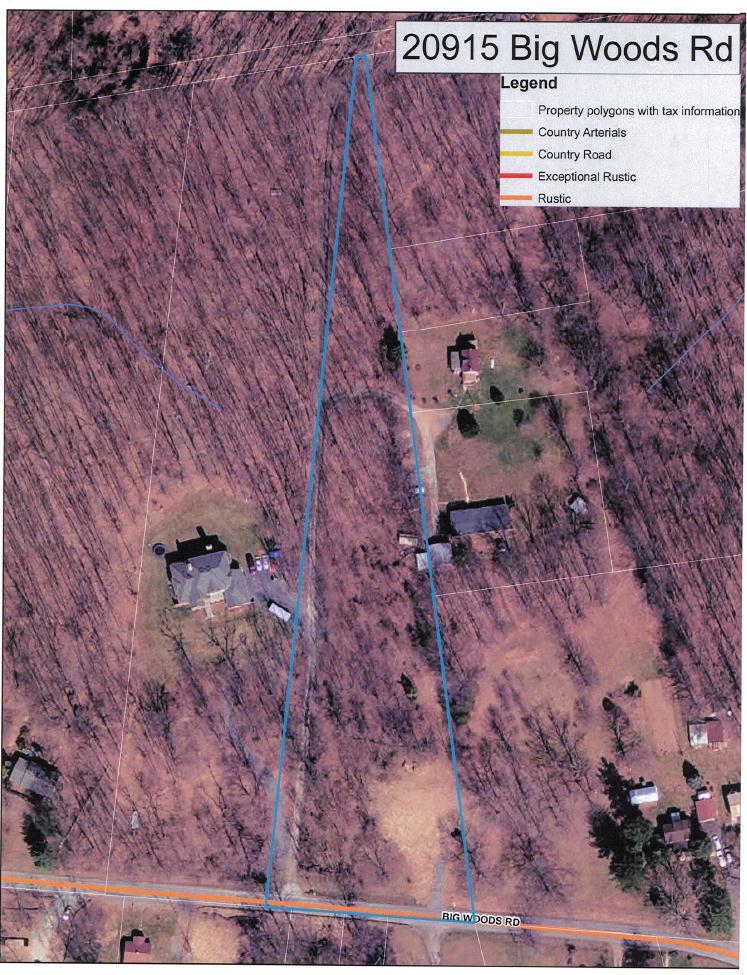
2 STAFF RECOMMENDATION Approval of a waiver of Section 50-35A(a)(6) of the Subdivision Regulations pursuant to section 50-38(a)(1) of the Subdivision Regulations in order to permit recordation of a plat through the minor subdivision process for a parcel created after June 1, 1958, subject to the following conditions: 1. Applicant must submit a complete Record Plat application within 120 days of the date of mailing of the Board s Resolution for this decision. 2. Road dedication and conservation easements must be shown on the plat. 3. All necessary easements for ingress/egress and public utilities must be shown on the plat. SITE DESCRIPTION The 2.59 acre property is an unplatted parcel (P795, Tax Map CV341) located at Big Woods Road in Beallsville, MD and zoned R-200 ( Property or Subject Property ). The Property is currently vacant but has an identifiable area where a house once stood. Surrounding uses within the immediate area along Big Woods Road are mostly residential on large lots and parcels. Agriculture is the predominant use beyond the homes that front on Big Woods Road. The Property contains forest and is moderately sloped with its highest elevation located in its center at 532 feet sloping to the north and south to its lowest elevation of 506 feet. The Property is shaped like a triangle having 220 feet of frontage on Big Woods Road tapering to 15 feet at its northernmost point. PROJECT DESCRIPTION The Applicant seeks a building permit to construct a house on the Property and until recently has been moving forward with plans under the assumption that the Property was exempt from platting. Under the premise of an exemption, a septic reserve area has been approved by the Montgomery County Department of Permitting Services and substantial work has been completed with Staff on meeting the forest conservation exemption requirements. The Montgomery County Department of Transportation supports the use of the existing driveway cut already in place. 2
3 3
4 4
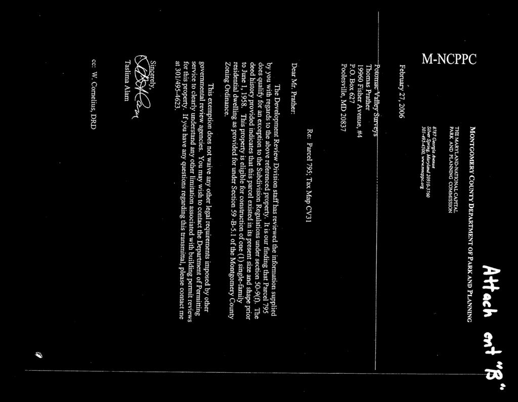
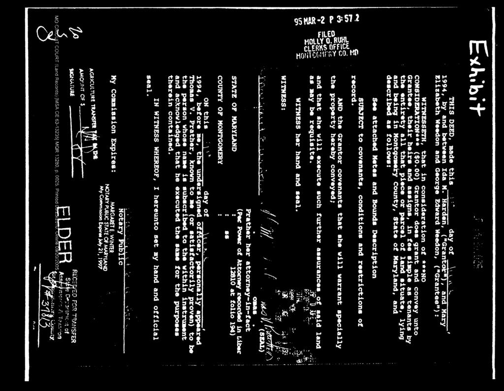
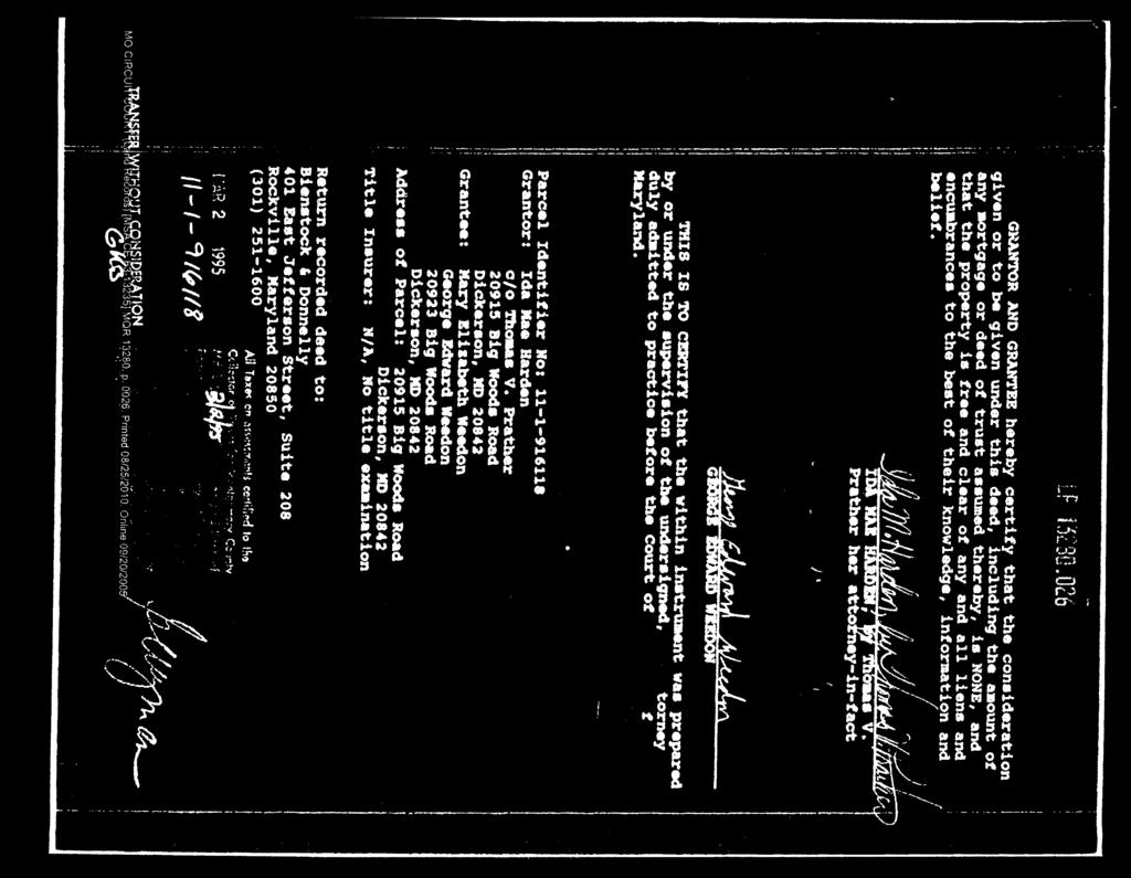
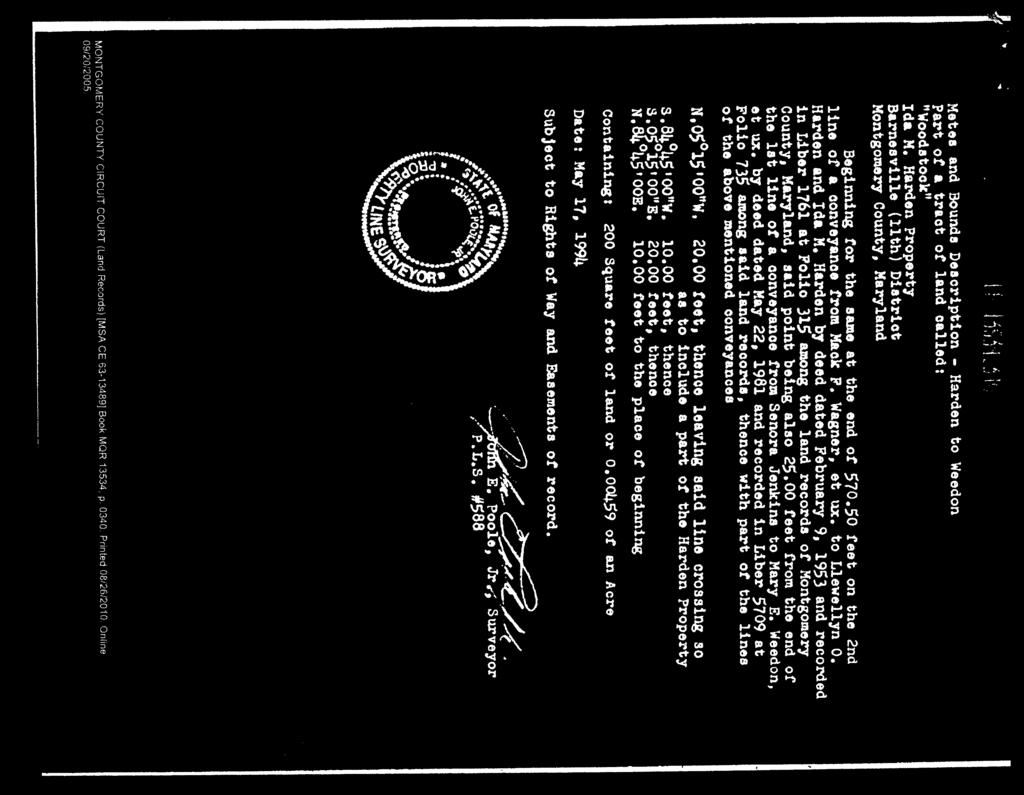
5 WAIVER REQUIREMENTS The Planning Board has the authority to grant waivers pursuant to Section 50-38(a)(1) of the Subdivision Regulations provided certain findings can be made. The section states: The Board may grant a waiver from the requirements of this Chapter upon a determination that practical difficulties or unusual circumstances exist that prevent full compliance with the requirements from being achieved, and that the waiver is: 1) the minimum necessary to provide relief from the requirements; 2) not inconsistent with the purposes and objectives of the General Plan; and 3) not adverse to the public interest. Section 50-35A(a)(6) of the Subdivision Regulations provides for owners of certain unplatted properties to proceed to a record plat without a preliminary plan approval: Plats for certain residentially zoned parcels created by deed before June 1, Although a single family residential parcel may qualify for an exception to platting under Section 50-9(f), if the parcel is developable for only one single family detached dwelling unit, then an owner may submit a plat to record such a parcel under the minor subdivision procedures This provision allows unplatted (deed) parcels that meet the exemption to platting requirements under 50-9(f) - deeded parcels that have not changed in size or shape since before June 1, 1958 ( Exempt Parcel ) to record a plat under the minor subdivision process. Because of a conveyance of 200 square feet in July 1995, the Subject Property no longer meets this requirement. DISCUSSION The Applicant purchased the Subject Property in 2010 with the intent to build a home and contracted with Potomac Valley Surveys (Attachment A). This firm had completed work for the previous owner of the Property to secure building permits but that owner died unexpectedly before a house could be built. Potomac Valley Surveys acquired many approvals for the previous owner, and the Applicant continued with the same firm. One of the documents that Potomac Valley Surveys acquired was an exception letter from Park and Planning dated February 27, 2006 (Attachment B), stating that the parcel was exempt under 50-9(f), from the requirement to plat prior to issuance of a building permit; referred to as an exemption letter. As an Exempt Parcel, the previous owner and Potomac Valley Surveys moved forward with plans with the assumption that no preliminary plan or record plat would be required and successfully conducted water table tests, septic percolation tests and removed the old house 1 to prepare the site for a new house. After the death of the previous owner, the Applicant moved forward with Potomac Valley Surveys also on the assumption that the parcel was exempt. After the Applicant contracted with Potomac Valley Surveys and submitted forest conservation material to staff in 2010, Staff discovered that the 2006 exemption letter was written in error. The deed history to the property indicates that in July, 1995, a conveyance of 200 square feet from the Subject Property 1 Note: Had this house remained standing today, the Property would qualify for platting under a recently adopted minor subdivision provision that allows platting of lots that meet the zoning in place when the house was built. 5
6 to an adjacent property owner essentially changed the size and shape of the property after June 1, The conveyance was done by mutual agreement between two land owners to address the ill-advised location of a well shaft drilled on the common property line between the Subject Property and the neighboring property. The Property is not an Exempt Parcel and; therefore, the Applicant is not able to get a building permit without first recording a plat. Had it not been for the 200 square feet conveyed to the adjacent property owner, the Property would be an Exempt Parcel. The erroneous 2006 exemption letter appears to have played a role in this matter and has now stalled the Applicant s efforts. WAIVER DISCUSSION Applicant s Position In a letter dated January 27, 2011, (Attachment C), supplemented by letters dated March 30, 2011, (Attachment D) and June 19, 2012, (Attachment E), the Applicant claims that an unusual circumstance exists that prevents full compliance with the Subdivision Regulations. The Applicant requests a waiver to allow a plat to be recorded under Section 50-35A(a)(6) of the minor subdivision process for a parcel that has changed in size and shape after June 1, The letter suggests that the unusual circumstance was created when the parcel was changed in size and shape, but only by 200 square feet and by a previous property owner and between agreeable neighbors. The Applicant acknowledges that a record plat is necessary but that a preliminary plan submission would delay him further and ultimately serve no useful purpose. He believes that most of the issues that would be resolved by a preliminary plan have already been addressed or can be addressed prior to the approval of a minor subdivision record plat. Stormwater management can be addressed as part of the sediment control or building permit review process. The letters explain that the 200 square foot conveyance was likely done without legal counsel and that, in hindsight, an easement over the same 200 square feet would have served the same purpose. The supplemental letters confirm that the Applicant s efforts to prepare the Property for a new home was initiated under the assumption that the exemption letter issued by Park and Planning was valid and that it was not until much later in the process did staff discover the. The letter has eventually caused his building permit to be delayed. The Applicant believes the waiver is the minimum necessary to provide relief from the requirement to submit a full subdivision and that the continued use of the R-200 zoned Subject Property for one house is consistent with the General Plan. The Applicant suggests that the eventual recordation of a plat sufficiently provides for the public interest and that the plat will ensure the building permit will be issued for a structure that meets all requirements of the County Code. A final comment is made regarding the hardship that has been placed on the Applicant and how that hardship would be extended both financially and time-wise if the waiver were not granted. Staff Position There are two unusual circumstances that justify the requested waiver. The first is the conveyance of a small 200 square foot portion of the 2.5 acre (112,820 square feet) parcel that resulted in the Property losing its exempt status. A deed conveyance in itself is not unusual; however, the size of the conveyance was unusually small and while it does change the size and shape of the parcel, it does not materially 6
7 alter the parcel s ability to accommodate a house nor did it create any issue for zoning conformance. No other buildable parcels were created by this conveyance; no additional lots are requested, and the Property remains well in excess of the minimum size requirements of the R-200 zone and meets all other zoning standards as shown in the table below: R-200 Requirements Proposed Minimum Size 112, 820 sf. (20,000 sf. min) Frontage on street 216 ft. (25 ft. min) Width at front b.r.l. 205 ft. (100 ft. min) Setbacks: Front (40 ft. min) House shown Rear (30 ft. min) meets all Side (12 ft. min/25 ft. setbacks. total) Max. lots permitted under 1 zone (5) The second unusual circumstance is the issuance of the erroneous exemption letter in 2006 that indicated the parcel had not changed in size or shape since June 1, 1958 and was otherwise exempt from platting. This is a governmental error that has led to a delay for the Applicant. Staff generally agrees that the submission of a preliminary plan in this instance will serve no purpose in the public interest. The Applicant has secured septic approval, well location approval, provided for dedication of Big Woods Road 35 feet from centerline, and will establish the necessary ingress/egress easements for the driveway that traverses the Subject Property and serves adjacent properties. The Property has received an exemption from forest conservation. It is not yet known if the Property can be developed under the limits of the exemption but any forest easements, if required, will be shown on the record plat that will ultimately be before the Planning Board for approval. Sediment control devices will be coordinated with any forest easements shown on the plat. There will be no adequate public facilities implications with respect to traffic, schools, or fire and rescue access. FINDINGS AND CONCLUSION Unusual Circumstances - Staff finds that there are two unusual circumstances that prevent this Applicant from fully complying with the requirements of the subdivision regulations. The first is the conveyance of relatively insignificant portion of the Property to an adjoining neighbor that effectively eliminated the exempt status the parcel once had. The second unusual circumstance is an erroneous exemption letter that provided incorrect information to the Applicant and caused a delay in the issuance of a building permit. The Property is no longer exempt from platting and must be recorded by plat before a building permit can be issued. The submission and review of a preliminary plan further delays the Applicant and provides no useful purpose that benefits the public interest. 7
8 Minimum Necessary - Staff finds that for this Property, the request to waive the requirement that a parcel be an Exempt Parcel in order to take advantage of the minor subdivision provision under 50-35A(a)(6) is the minimum necessary to provide relief from this requirement. Consistent with the General Plan - The waiver will allow a house to be replace one that was removed and locate it on a recorded lot. This community of homes along Big Woods Road is a rural community recognized by the AROS Plan which recommended the R-200 zone to allow these smaller properties to continue to conform to the zone as opposed to placing it in the Rural Density Transfer zone. Therefore, Staff finds that the waiver is consistent with the General Plan as amended by the AROS Plan. Public Interest - Further, Staff finds that the waiver is not adverse to the public interest as there is no additional public benefit that would be obtained through the submission and review of a Preliminary Plan. The eventual platting of the Property is in the public interest to assure conformity with zoning. Staff recommends approval of the requested waiver with the conditions cited above. Attachments: A. Contract with Potomac Valley Surveys B. February 27, 2006 exemption letter C. Waiver request letter dated January 27, 2011 D. Supplemental waiver request letter dated March 30, 2011 E. Supplemental waiver request letter dated July 19,
9 9
10 10
11 11
12 12
13 13
14 14
15
16
17 17
18 18
19 19
20 20
21 21
22 22
23 23
24 24
MONTGOMERY COUNTY PLANNING DEPARTMENT THE MARYLAND-NATIONAL CAPITAL PARK AND PLANNING COMMISSION
 MONTGOMERY COUNTY PLANNING DEPARTMENT THE MARYLAND-NATIONAL CAPITAL PARK AND PLANNING COMMISSION MCPB Item No. 3 Date: 01-31-13 Preliminary Plan 120090300, Boyds Highlands Calvin Nelson, Jr. Planner Coordinator,
MONTGOMERY COUNTY PLANNING DEPARTMENT THE MARYLAND-NATIONAL CAPITAL PARK AND PLANNING COMMISSION
 MONTGOMERY COUNTY PLANNING DEPARTMENT THE MARYLAND-NATIONAL CAPITAL PARK AND PLANNING COMMISSION MCPB Item No.: Date: 06-21-12 The Plantations, Preliminary Plan -120090240 Benjamin Berbert, Senior Planner,
RECOMMENDATION: Approval subject to the following conditions:
 RECOMMENDATION: Approval subject to the following conditions: 1) Approval under this preliminary plan is limited to 2 lots for 2 dwelling units 2) The record plat must note that the preliminary plan is
MONTGOMERY COUNTY PLANNING BOARD
 MONTGOMERY COUNTY PLANNING BOARD T H E MARYLAND-NATIONAL CAPITAL PARK A N D P L A N N I N G C O M M I S S I O N MCPB NO. 10-144 Hearing Date: September 30, 2010 MONTGOMERY COUNTY PLANNING BOARD RESOLUTION
MONTGOMERY COUNTY PLANNING DEPARTMENT THE MARYLAND-NATIONAL CAPITAL PARK AND PLANNING COMMISSION
 MONTGOMERY COUNTY PLANNING DEPARTMENT THE MARYLAND-NATIONAL CAPITAL PARK AND PLANNING COMMISSION MCPB Item No. Date: 12/4/14 Preliminary Plan No. 120140200, Northwood Knolls Description Patrick Butler,
MONTGOMERY COUNTY PLANNING DEPARTMENT THE MARYLAND-NATIONAL CAPITAL PARK AND PLANNING COMMISSION
 MONTGOMERY COUNTY PLANNING DEPARTMENT THE MARYLAND-NATIONAL CAPITAL PARK AND PLANNING COMMISSION MCPB Item No.: Date: 07-28-16 Lake Normandy Estates: Pre-Preliminary Plan No. 720160020 Ryan Sigworth AICP,
MONTGOMERY COUNTY PLANNING DEPARTMENT THE MARYLAND-NATIONAL CAPITAL PARK AND PLANNING COMMISSION
 MONTGOMERY COUNTY PLANNING DEPARTMENT THE MARYLAND-NATIONAL CAPITAL PARK AND PLANNING COMMISSION MCPB Item No. 8 Date: 03-07-13 Sonoma, Preliminary Plan, 120130040 Melissa Williams, Senior Planner, Melissa.williams@montgomeryplanning.org,
MONTGOMERY COUNTY PLANNING DEPARTMENT THE MARYLAND-NATIONAL CAPITAL PARK AND PLANNING COMMISSION
 MONTGOMERY COUNTY PLANNING DEPARTMENT THE MARYLAND-NATIONAL CAPITAL PARK AND PLANNING COMMISSION MCPB Consent Item Date: 12/19/13 * Consent Item Barton Property: Preliminary Plan Amendment No. 12011021A
MONTGOMERY COUNTY PLANNING DEPARTMENT THE MARYLAND-NATIONAL CAPITAL PARK AND PLANNING COMMISSION
 MONTGOMERY COUNTY PLANNING DEPARTMENT THE MARYLAND-NATIONAL CAPITAL PARK AND PLANNING COMMISSION MCPB Item No. Date: 1-17-13 Preliminary Plan 120110180 - Parmjit & Saini Estates Katherine Holt, Senior
Article Optional Method Requirements
 Article 59-6. Optional Method Requirements [DIV. 6.1. MPDU DEVELOPMENT IN RURAL RESIDENTIAL AND RESIDENTIAL ZONES Sec. 6.1.1. General Requirements... 6 2 Sec. 6.1.2. General Site and Building Type Mix...
Montgomery Village - South Valley Park: Subdivision Regulation Waiver SRW , and Site Plan No
 Montgomery Village - South Valley Park: Subdivision Regulation Waiver SRW - 201402, and Site Plan No. 820140070 12 SUBDIVISION REGULATION WAIVER RECOMMENDATION AND CONDITIONS OF APPROVAL Staff recommends
TULSA PARK ESTATES SUBDIVISION, RESUBDIVISION OF LOT 6
 TULSA PARK ESTATES SUBDIVISION, RESUBDIVISION OF LOT 6 Engineering Comments: FINAL PLAT COMMENTS (should be addressed prior to submitting the FINAL PLAT for review and/or signature by the City Engineer):
CITY OF MANHATTAN BEACH COMMUNITY DEVELOPMENT DEPARTMENT STAFF REPORT. Marisa Lundstedt, Director of Community Development
 CITY OF MANHATTAN BEACH COMMUNITY DEVELOPMENT DEPARTMENT STAFF REPORT TO: FROM: Planning Commission Marisa Lundstedt, Director of Community Development THROUGH: Laurie B. Jester, Planning Manager BY: Ted
Chesapeake Bay Critical Area Conservation Plan
 The Maryland-National Capital Park and Planning Commission Prince George s County Planning Department Development Review Division 301-952-3530 Note: Staff reports can be accessed at www.mncppc.org/pgco/planning/plan.htm.
FINAL DRAFT 12/1/16, Rev. to 7/18/17
 FINAL DRAFT 12/1/16, Rev. to 7/18/17 (As Adopted 8/8/17 Effective 9/1/17) SHELTON PLANNING AND ZONING COMMISSION Proposed Amendments to Zoning Regulations I. Amend Section 23 PERMITTED USES by inserting
KANKAKEE COUNTY PLANNING DEPARTMENT APPLICATION FOR FARMSTEAD EXEMPTION IN THE A1 DISTRICT
 KANKAKEE COUNTY PLANNING DEPARTMENT APPLICATION FOR FARMSTEAD EXEMPTION IN THE A1 DISTRICT Michael J. Van Mill, AICP Planning Director 189 East Court Street Kankakee, IL 60901 Telephone (815) 937-2940
PLANNED UNIT DEVELOPMENT & ZONING AMENDMENT STAFF REPORT Date: December 21, 2017
 # 14 PUD-000324-2017 & ZON-000326-2017 PLANNED UNIT DEVELOPMENT & ZONING AMENDMENT STAFF REPORT Date: December 21, 2017 APPLICANT NAME DEVELOPMENT NAME LOCATION Dewberry/Preble-Rish Longleaf Gates Subdivision,
Amendment to the Zoning and Subdivision Ordinances; Consider Repeal Cluster Development Standards
 2 Board of Supervisors Meg Bohmke, Chairman Gary F. Snellings, Vice Chairman Jack R. Cavalier Thomas C. Coen L. Mark Dudenhefer Wendy E. Maurer Cindy C. Shelton February 28, 2018 Thomas C. Foley County
MONTGOMERY COUNTY PLANNING BOARD
 MONTGOMERY COUNTYPLANNING BOARD T H E MARYLAND-NATIONAL CAPITAL PARK A N D P L A N N I N G C O M M I S S I O N MCPB NO. 10-100 Preliminary Plan No. 120100210 Date of Hearing: July 1, 2010 MONTGOMERY COUNTY
ARTICLE VII. NONCONFORMITIES. Section 700. Purpose.
 ARTICLE VII. NONCONFORMITIES. Section 700. Purpose. The purpose of this chapter is to regulate and limit the development and continued existence of legal uses, structures, lots, and signs established either
SUBDIVISION DEFINED, EXEMPTIONS FROM DEFINITION:
 12-611: SUBDIVISION DEFINED, EXEMPTIONS FROM DEFINITION: A. 1. Minor Land Division (MLD) shall mean any division of land into four (4) or fewer lots. 2. Minor Subdivision shall mean any division of land
PLANNING COMMISSION REPORT REGULAR AGENDA
 PP-4-4-11 Item No. 9-1 PLANNING COMMISSION REPORT REGULAR AGENDA PC Staff Report 06/22/11 ITEM NO 9: PRELIMINARY PLAT; KASOLD WATER TOWER ADDITION; SE OF TAM O SHANTER & KASOLD DR (MKM) PP-4-4-11: Consider
APPLICATION FOR LOT SPLIT
 APPLICATION FOR LOT SPLIT ELIGIBILITY Section 12.09.01 of the Land Development Code provides for review and approval of lot split, which shall include any of the following: 1. The division of a single
610 LAND DIVISIONS AND PROPERTY LINE ADJUSTMENTS OUTSIDE A UGB
 ARTICLE VI: LAND DIVISIONS AND PROPERTY LINE ADJUSTMENTS VI-21 610 LAND DIVISIONS AND PROPERTY LINE ADJUSTMENTS OUTSIDE A UGB 610-1 Property Line Adjustments (Property Line Relocation) A property line
R E S O L U T I O N. a. Remove Table B from the plan.
 R E S O L U T I O N WHEREAS, Werrlein Property is the owner of a 0.3902-acre parcel of land in the 5th Election District of Prince George s County, Maryland, being zoned One-Family Detached Residential
CITY OF CASCADE LOCKS PLANNING COMMISSION ORDER VARIANCE WINDSONG TERRACE LLC
 CITY OF CASCADE LOCKS PLANNING COMMISSION ORDER VARIANCE 07-01 WINDSONG TERRACE LLC APPLICATION The variance requested is to reduce various setback requirements for lots within the Windsong Terrace Subdivision.
LAND SPLIT APPLICATION AND SUBMITTAL REQUIREMENTS
 LAND SPLIT APPLICATION AND SUBMITTAL REQUIREMENTS PARCELS 2.5> ACRES OR SMALLER: THIS APPLICATION IS REQUIRED TO DIVIDE LAND INTO TWO OR THREE PARCELS. PARCELS LARGER THAN 2.5 ACRES: THIS APPLICATION IS
MONTGOMERY COUNTY PLANNING DEPARTMENT THE MARYLAND-NATIONAL CAPITAL PARK AND PLANNING COMMISSION
 MONTGOMERY COUNTY PLANNING DEPARTMENT THE MARYLAND-NATIONAL CAPITAL PARK AND PLANNING COMMISSION MCPB Item No. Date: 10-03-13 Preliminary Plan Amendment No. 11999034B Alvermar Woods, Lot 17 (In Response
TABLE (A): TABLE OF DIMENSIONAL STANDARDS IN THE RESIDENTIAL ZONE DISTRICTS REQUIRED YARDS [4], [5] SIDE YARD (FT) REAR YARD (FT) R-1 DISTRICT
![TABLE (A): TABLE OF DIMENSIONAL STANDARDS IN THE RESIDENTIAL ZONE DISTRICTS REQUIRED YARDS [4], [5] SIDE YARD (FT) REAR YARD (FT) R-1 DISTRICT](/thumbs/85/92855381.jpg "TABLE (A): TABLE OF DIMENSIONAL STANDARDS IN THE RESIDENTIAL ZONE DISTRICTS REQUIRED YARDS [4], [5] SIDE YARD (FT) REAR YARD (FT) R-1 DISTRICT") ARTICLE : DENSITY, INTENSITY, & DIMENSIONAL STANDARDS Section -100: General Provisions TABLE 17--100(A): TABLE OF DIMENSIONAL STANDARDS IN THE RESIDENTIAL ZONE DISTRICTS R-1 DISTRICT AREA (SQ FT)[3] WIDTH
ARTICLE : DENSITY, INTENSITY, & DIMENSIONAL STANDARDS Section -100: General Provisions TABLE 17--100(A): TABLE OF DIMENSIONAL STANDARDS IN THE RESIDENTIAL ZONE DISTRICTS R-1 DISTRICT AREA (SQ FT)[3] WIDTH
ELK RAPIDS TOWNSHIP ANTRIM COUNTY, MICHIGAN ORDINANCE NO
 ELK RAPIDS TOWNSHIP ANTRIM COUNTY, MICHIGAN ORDINANCE NO. 3-2011 AN ORDINANCE TO REPLACE THE SUBDIVISION CONTROL ORDINANCE WITH A NEW SUBDIVISION DEVELOPMENT ORDINANCE, IN ACCORD WITH THE LAND DIVISION
MONTGOMERY COUNTY PLANNING DEPARTMENT
 MONTGOMERY COUNTY PLANNING DEPARTMENT THE MARYLAND-NATIONAL CAPITAL PARK AND PLANNING COMMISSION Forest Conservation Law Amendments - Modifications MCPB Item No. 7 Date: 5/24/2018 SUMMARY Mark Pfefferle,
WESTMINSTER PARK SUBDIVISION
 WESTMINSTER PARK SUBDIVISION Engineering Comments: FINAL PLAT COMMENTS (should be addressed prior to submitting the FINAL PLAT for review and/or signature by the City Engineer): A. Provide all of the required
(Draft Glenville ordinance, June 2008) ARTICLE XXII Transfer of Development Rights
 ARTICLE XXII Transfer of Development Rights") (Draft Glenville ordinance, June 2008) ARTICLE XXII Transfer of Development Rights 270-161. Purpose. The primary purpose of establishing a transfer of development rights (TDR) program is to permanently
(Draft Glenville ordinance, June 2008) ARTICLE XXII Transfer of Development Rights 270-161. Purpose. The primary purpose of establishing a transfer of development rights (TDR) program is to permanently
KRONER S MOBILE WEST COMMERCIAL BUSINESS PARK SUBDIVISION
 KRONER S MOBILE WEST COMMERCIAL BUSINESS PARK SUBDIVISION Engineering Comments: Must comply with the Mobile County Flood Damage Prevention Ordinance. Development shall be designed to comply with the storm
DAWES SWITCHING STATION SUBDIVISION
 DAWES SWITCHING STATION SUBDIVISION Engineering Comments: Must comply with the Mobile County Flood Damage Prevention Ordinance. Development shall be designed to comply with the storm water detention and
STAFF REPORT. Arthur and Kathleen Quiggle 4(b)
") STAFF REPORT Application: Requests related to the construction of a 28' x 41' dwelling and 6' wrap-around open deck to replace an existing 24' x 32' cabin and wrap-around open deck and the installation
STAFF REPORT Application: Requests related to the construction of a 28' x 41' dwelling and 6' wrap-around open deck to replace an existing 24' x 32' cabin and wrap-around open deck and the installation
PLANNED UNIT DEVELOPMENT & SUBDIVISION STAFF REPORT Date: May 6, 2004
 # 3. & 4. File # ZON2004-00967 & SUB2004-00085 PLANNED UNIT DEVELOPMENT & SUBDIVISION STAFF REPORT Date: May 6, 2004 DEVELOPMENT NAME SUBDIVISION NAME Heron Lakes Subdivision, Phase One, Revised Lot 32
MONTGOMERY COUNTY PLANNING DEPARTMENT THE MARYLAND-NATIONAL CAPITAL PARK AND PLANNING COMMISSION
 MONTGOMERY COUNTY PLANNING DEPARTMENT THE MARYLAND-NATIONAL CAPITAL PARK AND PLANNING COMMISSION Ganassa Property, Preliminary Plan, 120040640 MCPB Item No. Date: 7-25-13 Callum Murray, Area 3 Supervisor,
Chapter SPECIAL USE ZONING DISTRICTS
 Chapter 20.20 Sections: 20.20.010 Urban Transition (U-T) Zoning District 20.20.020 Planned Development (P-D) Zoning Districts 20.20.010 Urban Transition (U-T) Zoning District A. Purpose. The purpose of
PLANNED UNIT DEVELOPMENT & SUBDIVISION STAFF REPORT August 18, 2016
 PLANNED UNIT DEVELOPMENT & SUBDIVISION STAFF REPORT August 18, 2016 DEVELOPMENT NAME SUBDIVISION NAME Mullinax Ford Subdivision Mullinax Ford Subdivision LOCATION CITY COUNCIL DISTRICT District 6 Southeast
MONTGOMERY COUNTY PLANNING DEPARTMENT THE MARYLAND-NATIONAL CAPITAL PARK AND PLANNING COMMISSION
 MONTGOMERY COUNTY PLANNING DEPARTMENT THE MARYLAND-NATIONAL CAPITAL PARK AND PLANNING COMMISSION MCPB Item No. Date: 05-30-13 Pre-Preliminary Plan No. 720130040: Potomac Highlands Callum Murray, supervisor,
Committed to Service
 Committed to Service Paul Woods, President Rebecca W. Arnold, Vice President Sara M. Baker, Commissioner Jim D. Hansen, Commissioner Kent Goldthorpe, Commissioner August 25, 2017 Development Services TO:
CITY OF MANHATTAN BEACH COMMUNITY DEVELOPMENT DEPARTMENT STAFF REPORT. Marisa Lundstedt, Director of Community Development
 CITY OF MANHATTAN BEACH COMMUNITY DEVELOPMENT DEPARTMENT STAFF REPORT TO: FROM: Planning Commission Marisa Lundstedt, Director of Community Development THROUGH: Laurie B. Jester, Planning Manager BY: Ted
4. facilitate the construction of streets, utilities and public services in a more economical and efficient manner;
 PVPC MODEL BYLAW BY-RIGHT CLUSTER ZONING BYLAW Prepared by Pioneer Valley Planning Commission Revised: October 2001 1.00 Development 1.01 Development Allowed By Right Development in accordance with this
I. Requirements for All Applications. C D W
 108-16.1. Application checklists. Checklist for Required Submissions to the Planning Board or Zoning Board of Adjustment of Monroe Township All required submissions are to be made to the Administrative
MONTGOMERY COUNTY CODE Chapter 50. Chapter 50. SUBDIVISION OF LAND.
 MONTGOMERY COUNTY CODE Chapter 50 Chapter 50. SUBDIVISION OF LAND. Article I. In General. Division 50.1. Purpose Section 50.1.1. Purpose of Chapter 1 Division 50.2. Defined Terms Section 50.2.1. Rules
DEVELOPMENT DEPARTMENT STAFF REPORT STAFF REPORT DRESDEN DRIVE TOWNHOMES DCI
 DEVELOPMENT DEPARTMENT STAFF REPORT Meeting Date: September 13, 2018 Item #: PZ2018-319 STAFF REPORT DRESDEN DRIVE TOWNHOMES DCI Request: Project Name: Development of Community Compact (DCI) and six concurrent
PLANNING AND DEVELOPMENT DEPARTMENT STAFF REPORT STAFF REPORT PREMIER AUTO SERVICES, INC. VARIANCES
 PLANNING AND DEVELOPMENT DEPARTMENT STAFF REPORT Meeting Date: February 14, 2019 Item #: PZ2019-402 STAFF REPORT PREMIER AUTO SERVICES, INC. VARIANCES Project Name: Premier Auto Services, Inc. Applicant:
ARTICLE III GENERAL PROCEDURES, MINOR PLANS AND FEE SCHEDULES
 ARTICLE III GENERAL PROCEDURES, MINOR PLANS AND FEE SCHEDULES 301. Prior to Submission a. Copies of this Ordinance shall be available on request, at cost, for the use of any person who desires information
CHAPTER 50 MONTGOMERY COUNTY SUBDIVISION REGULATIONS
 CHAPTER 50 MONTGOMERY COUNTY SUBDIVISION REGULATIONS Effective February 13, 2017 Sec. 3. Effective Date. This amendment takes effect on February 13, 2017. The amendment applies to any Planning Board action
ZONING AMENDMENT, PLANNED UNIT DEVELOPMENT & SUBDIVISION STAFF REPORT Date: August 8, 2013
 ZONING AMENDMENT, PLANNED UNIT DEVELOPMENT & SUBDIVISION STAFF REPORT Date: August 8, 2013 NAME SUBDIVISION NAME PV-Magnolia, LLC Twelve Trees Subdivision LOCATION 2860, 2862 and 2866 Pleasant Valley Road
ARTICLE FIVE FINAL DRAFT
 ARTICLE FIVE 021218 FINAL DRAFT Sec. 503.6 Open Space Preservation Option Open Space Preservation Option Open Space Preservation developments may be approved in the AR, R-1, R-2 and R-3 zoning districts,
BAY FOREST PARK SUBDIVISION, RESUBDIVISION OF LOTS 6 & 7 AND BAY FOREST PARK SUBDIVISION LOT 10, OF THE RESUBDIVISON OF LOTS 9 & 10
 BAY FOREST PARK SUBDIVISION, RESUBDIVISION OF LOTS 6 & 7 AND BAY FOREST PARK SUBDIVISION LOT 10, OF THE RESUBDIVISON OF LOTS 9 & 10 Engineering Comments: Must comply with the Mobile County Flood Damage
PORT CITY COMMERCE PARK SUBDIVISION
 # 4 SUB2015-00019 PORT CITY COMMERCE PARK SUBDIVISION Engineering Comments: Must comply with the Mobile County Flood Damage Prevention Ordinance. Development shall be designed to comply with the storm
MONTGOMERY COUNTY PLANNING DEPARTMENT THE MARYLAND-NATIONAL CAPITAL PARK AND PLANNING COMMISSION
 MONTGOMERY COUNTY PLANNING DEPARTMENT THE MARYLAND-NATIONAL CAPITAL PARK AND PLANNING COMMISSION MCPB Item No. Date: 12/6/12 Limited Site Plan Amendment, 82000018D, DANAC Stiles Property, Lot 6 of Block
ZONING ORDINANCE: OPEN SPACE COMMUNITY. Hamburg Township, MI
 ZONING ORDINANCE: OPEN SPACE COMMUNITY Hamburg Township, MI ARTICLE 14.00 OPEN SPACE COMMUNITY (Adopted 1/16/92) Section 14.1. Intent It is the intent of this Article to offer an alternative to traditional
O-I (Office-Institutional) and AG-1(Agricultural)
 and AG-1(Agricultural)") PROPERTY INFORMATION ADDRESS 3503 and 3505 Bethany Bend DISTRICT, LAND LOTS 2/1 973 and 974 OVERLAY DISTRICT State Route 9 PETITION NUMBERS EXISTING ZONING O-I (Office-Institutional) and AG-1(Agricultural)
PROPERTY INFORMATION ADDRESS 3503 and 3505 Bethany Bend DISTRICT, LAND LOTS 2/1 973 and 974 OVERLAY DISTRICT State Route 9 PETITION NUMBERS EXISTING ZONING O-I (Office-Institutional) and AG-1(Agricultural)
A. Appropriate agency responsible for transportation review for the subject property.
 7.8.10 Procedure Any person desiring to create a minor subdivision shall submit to the Commission for approval an application on forms provided by the Division, and a record plat in conformance with the
Subtitle 24 Revision to incorporate SGT SB 236 8/3/2012 STAFF DRAFT 2
 Subtitle 24 Revisions DRAFT 2 Definitions: Section 24-101 Remainder Agricultural Parcel-On or after October 1, 2012 pursuant to Section 9-206 of the Environment Article a remainder parcel is created by
ARTICLE 759. PD 759. PD 759 was established by Ordinance No , passed by the Dallas City Council on June 27, (Ord. Nos.
 ARTICLE 759. PD 759. SEC. 51P-759.101. LEGISLATIVE HISTORY. PD 759 was established by Ordinance No. 26871, passed by the Dallas City Council on June 27, 2007. (Ord. Nos. 26871; 29304) SEC. 51P-759.102.
The Tulsa Metropolitan Area Planning Commission (TMAPC) has jurisdiction for all of the City of Tulsa and the unincorporated parts of Tulsa County.
 has jurisdiction for all of the City of Tulsa and the unincorporated parts of Tulsa County.") Know What a Lot-Split Is, and When It Is Required The Tulsa Metropolitan Area Planning Commission (TMAPC) has jurisdiction for all of the City of Tulsa and the unincorporated parts of Tulsa County. The
Know What a Lot-Split Is, and When It Is Required The Tulsa Metropolitan Area Planning Commission (TMAPC) has jurisdiction for all of the City of Tulsa and the unincorporated parts of Tulsa County. The
Open Space Model Ordinance
 Open Space Model Ordinance Section I. Background Open space development has numerous environmental and community benefits, including: 1) Reduces the impervious cover in a development. Impervious cover
Town of Norwich, Vermont SUBDIVISION REGULATIONS
 Town of Norwich, Vermont SUBDIVISION REGULATIONS Adopted: August 6, 2002 Amended: February 8, 2006 Prepared by Norwich Planning Commission with the assistance of: Burnt Rock Inc. A ssociates in Community
ORDINANCE NUMBERb5"- 03
 ORDINANCE NUMBERb5"- 03 AMENDMENTS TO THE MASON COUNTY DEVELOPMENT REGULATIONS AND TITLE 16 (PLATS AND SUBDIVISIONS) REGARDING BOUNDARY LINE ADJUSTMENTS. AN ORDINANCE amending the Mason County Development
A.3. ARTICLE 7 PLAN REQUIREMENTS FOR MINOR SUBDIVISION AND/OR LAND DEVELOPMENT
 700. 701.A.3. ARTICLE 7 PLAN REQUIREMENTS FOR MINOR SUBDIVISION AND/OR LAND DEVELOPMENT SECTION 700 PURPOSE The purpose of this Article is to set forth a streamlined set of Plan Requirements for minor
9. MIXED HOUSING TYPES AND AFFORDABILITY
 92 Section 6 The Neighborhood Model: Building Block for the Development Areas 9. MIXED HOUSING TYPES AND AFFORDABILITY MIXED HOUSING TYPES Mixing housing types successfully requires first understanding
PUBLIC REVIEW MEETING
 Douglas S. Wright, Jr., chair, opened the meeting at 7:01 p.m., on Wednesday, September 26, 2018, in the Council Chamber, Second Floor, City Hall. Also present were commission members S. McIntire, J. Stone,
DISTRICT COUNCIL FOR PRINCE GEORGE S COUNTY, MARYLAND OFFICE OF ZONING HEARING EXAMINER SPECIAL EXCEPTION 4658 DECISION
 DISTRICT COUNCIL FOR PRINCE GEORGE S COUNTY, MARYLAND OFFICE OF ZONING HEARING EXAMINER SPECIAL EXCEPTION 4658 DECISION Application: Three Chair Barber Shop Applicants: Danta L. & Felicia B. Wright/Fort
EL DORADO COUNTY DEVELOPMENT SERVICES ZONING ADMINISTRATOR STAFF REPORT VARIANCE
 EL DORADO COUNTY DEVELOPMENT SERVICES ZONING ADMINISTRATOR STAFF REPORT Agenda of: August 6, 2008 Item No.: Staff: 4.d. Robert Peters VARIANCE FILE NUMBER: V08-0004 APPLICANT: Joseph and Ingrid Herrick
MINUTES 7:30 PM. Block 40, Lots 8 & 8.04 Minor Subdivision Tumble Falls Road Completeness Determination
 MINUTES 7:30 PM PRESENT: R. Dodds ABSENT: P. Lubitz D. Haywood L. Riggio J. Mathieu M. Syrnick S. McNicol L. Voronin, Alt #1 J. Strasser C. Ely, Alt #2 CALL TO ORDER The meeting was called to order by
Approval to Enter Into Negotiations with Montgomery County on Sale of Property
 Planning, Development and Real Estate Committee Board Action Item III-B October 11, 2007 Approval to Enter Into Negotiations with Montgomery County on Sale of Property Washington Metropolitan Area Transportation
PROVISION POINTE SUBDIVISION
 PROVISION POINTE SUBDIVISION Engineering Comments: Must comply with the Mobile County Flood Damage Prevention Ordinance. Development shall be designed to comply with the storm water detention and drainage
DEVELOPMENT DEPARTMENT STAFF REPORT STAFF REPORT EASTSIDE CHAMBLEE LINK DCI
 DEVELOPMENT DEPARTMENT STAFF REPORT Public Hearing Date: April 12, 2018 Item #: PZ-2018-248 STAFF REPORT EASTSIDE CHAMBLEE LINK DCI Request: Development of Community Compact (DCI), ten concurrent variances,
WESTMINSTER PARK PLACE SUBDIVISION
 WESTMINSTER PARK PLACE SUBDIVISION Engineering Comments: FINAL PLAT COMMENTS (should be addressed prior to submitting the FINAL PLAT for review and/or signature by the City Engineer): A. Provide all of
ALBA BEACH SUBDIVISION, RESUBDIVISION OF LOT 17
 ALBA BEACH SUBDIVISION, RESUBDIVISION OF LOT 17 Engineering Comments: FINAL PLAT COMMENTS (should be addressed prior to submitting the FINAL PLAT for acceptance and signature by the City Engineer): A.
MONTGOMERY COUNTY PLANNING DEPARTMENT THE MARYLAND-NATIONAL CAPITAL PARK AND PLANNING COMMISSION
 MONTGOMERY COUNTY PLANNING DEPARTMENT THE MARYLAND-NATIONAL CAPITAL PARK AND PLANNING COMMISSION MCPB Item No. 6 Date: 9-27-18 Seneca Farms, Preliminary Plan No. 120170240 Jonathan Casey, Senior Planner,
DEVELOPMENT DEPARTMENT STAFF REPORT DRESDEN HEIGHTS PHASE II DCI
 DEVELOPMENT DEPARTMENT Meeting Date: January 10, 2019 Item #: PZ2019-393 Project Name: Applicant and Owner: Proposed Development: Requests: STAFF REPORT DRESDEN HEIGHTS PHASE II DCI Dresden Heights Phase
19.12 CLUSTER RESIDENTIAL DISTRICT
 Chapter 19.12 CLUSTER RESIDENTIAL DISTRICT (Adopted 12/22/2003; Ordinance #0061970). Amended 7/3/17, Ordinance #079100. Section 19.12.010 - Declaration of Intent. The Cluster Residential District provides
SILVER PINES SUBDIVISION
 SILVER PINES SUBDIVISION Engineering Comments: Must comply with the Mobile County Flood Damage Prevention Ordinance. The plat illustrates the proposed 39.4+ acre, 153 lot subdivision, which is located
BRIDGETON SUBDIVISION APPLICATION CHECKLIST
 APPLICATION NAME AND # CHECKLIST COMPLETED BY: DATE: Signature and printed name BRIDGETON SUBDIVISION APPLICATION CHECKLIST TO SUBDIVISION APPLICANTS: The attached checklist is to assist you in the submission
SECTION 874 SITE PLAN REVIEW
 SECTION 874 SITE PLAN REVIEW When a site plan review is required by this Division or Chapters 17.72 or 17.30 of the Fresno County Ordinance Code, the following procedure shall apply: A. SITE PLAN The purpose
ARTICLE OPTIONAL METHOD REGULATIONS
 ARTICLE 59-6. OPTIONAL METHOD REGULATIONS DIV. 6.1. MPDU DEVELOPMENT IN RURAL RESIDENTIAL AND RESIDENTIAL ZONES SEC. 6.1.1. GENERAL REQUIREMENTS... 6 2 SEC. 6.1.2. GENERAL SITE AND BUILDING T PE MIX...
By motion dated January 3, 2 008, the New Jersey Council. on Affordable Housing (the "Council" or "COAH") received a request
 received a request") IN RE ROCKAWAY TOWNSHIP, MORRIS ) NEW JERSEY COUNCIL ON COUNTY, MOTION FOR A STAY OF ) ON AFFORDABLE HOUSING THE COUNCIL'S JUNE 13, 2 007 AND, ) SEPTEMBER 12, 2007 RESOLUTIONS ) DOCKET NO. 08-2000 AND
IN RE ROCKAWAY TOWNSHIP, MORRIS ) NEW JERSEY COUNCIL ON COUNTY, MOTION FOR A STAY OF ) ON AFFORDABLE HOUSING THE COUNCIL'S JUNE 13, 2 007 AND, ) SEPTEMBER 12, 2007 RESOLUTIONS ) DOCKET NO. 08-2000 AND
17.0 NONCONFORMITIES CHAPTER 17: NONCONFORMITIES Purpose and Applicability
 17.0 NONCONFORMITIES 17.1 Purpose and Applicability The purpose of this section is to regulate and limit the continued existence of uses and structures established prior to the effective date of this Ordinance
Zoning Code Training MONTGOMERY COUNTY PLANNING DEPARTMENT. Maryland-National Capital Park and Planning Commission
 Zoning Code Training Highlights New code was adopted on March 5 & DMA was adopted on July 15. Both become effective on October 30. ZTA 14-09 was approved Sept 30 and updates, clarifies, and corrects errors
TERRY POIROUX FAMILY DIVISION SUBDIVISION
 TERRY POIROUX FAMILY DIVISION SUBDIVISION Engineering Comments: Must comply with the Mobile County Flood Damage Prevention Ordinance. Development shall be designed to comply with the storm water detention
TOWN OF NORTHAMPTON PLANNING BOARD MAY 8, :00 P.M. TOWN HALL MEETING NOTES
 TOWN OF NORTHAMPTON PLANNING BOARD MAY 8, 2018 7:00 P.M. TOWN HALL MEETING NOTES PRESENT: ROBERT SMITH, CHAIRMAN (via Facetime 655 Luisa Lane #4 Naples FL 34104) STEVEN NAPLE JAMES CONKLING JACK GROFF
MONTGOMERY COUNTY PLANNING BOARD THE MARYLAND-NATIONAL CAPITAL PARK AND PLANNING COMMISSION
 MONTGOMERY COUNTY PLANNING BOARD THE MARYLAND-NATIONAL CAPITAL PARK AND PLANNING COMMISSION APPROVED MINUTES The Montgomery County Planning Board met in regular session on Thursday, February 19, 2015,
1. APPLICANT: Polsinelli, Shalton & Welte is the applicant for this request.
 5. REVISED PRELIMINARY PLAN APPROVAL - THE RETREAT AT MAPLECREST - Vicinity of the northeast corner of 159 th Street and U.S. 69 Highway 1. APPLICANT: Polsinelli, Shalton & Welte is the applicant for this
PROPOSED FINIDINGS ZONE VARIANCE APPLICATION FOR HEIGHT VARIANCE
 PROPOSED FINIDINGS ZONE VARIANCE APPLICATION FOR HEIGHT VARIANCE (PURSUANT TO LOS ANGELES MUNICIPAL CODE SECTION 12.27) CONCERNING 10550 WEST BELLAGIO ROAD, LOS ANGELES, CA 90077 Pursuant to Charter Section
CHAPTER NONCONFORMITIES.
 - i CHAPTER. - NONCONFORMITIES. Sec. -. - Intent. Sec. -2. - Development as a matter of right. Sec. -3. - Nonconforming development. Sec. -. - Vested rights. Sec. -. - Hardship relief; Variances. 2 3 admin.
DEPARTMENT OF PLANNING JEFFERSON PARISH, LOUISIANA
 DEPARTMENT OF PLANNING JEFFERSON PARISH, LOUISIANA SUBDIVISION REPORT DOCKET NO: ES-89-15-PF SUMMARY NO: COUNCIL DISTRICT 2 Paul D. Johnston COUNCIL AT LARGE: A Chris Roberts B Elton M. Lagasse ADVERTISING
ARTICLE 8C SITE CONDOMINIUM DEVELOPMENT ORDINANCE
 ARTICLE 8C SITE CONDOMINIUM DEVELOPMENT ORDINANCE SECTION 8C.01 PURPOSE It is the purpose of this Ordinance to insure that plans for development within Oceola Township proposed under the provisions of
APPLICATION FOR EXEMPT SUBDIVISION: NON-LOT SPLIT
 APPLICATION FOR EXEMPT SUBDIVISION: NON-LOT SPLIT ELIGIBILITY Section 12.08.03.c of the Land Development Code provides for review and approval of exempt subdivisions, which shall include any of the following:
BYRON TOWNSHIP ZONING APPLICATION
 BYRON TOWNSHIP ZONING APPLICATION Phone: (616) 878-9104 * Fax: (616) 878-3980 * Website: www.byrontownship.org This application will not be accepted if incomplete. APPLICATION FOR & REQUIRED COPIES Private
CHAPTER 50 MONTGOMERY COUNTY SUBDIVISION REGULATIONS PLANNING BOARD DRAFT July 31, 2015
 CHAPTER 50 MONTGOMERY COUNTY SUBDIVISION REGULATIONS PLANNING BOARD DRAFT July 31, 2015 Chapter 50: Subdivision Regulations Page Intentionally Blank Chapter 50: Subdivision Regulations TABLE OF CONTENTS
City of San Juan Capistrano Agenda Report
 City of San Juan Capistrano Agenda Report TO: Zoning Administrator FROM: Reviewed by: Sergio Klotz, AICP, Assistant Development Services DirctJ. o ~ Prepared by: Laura Stokes, Housing Coordinator I Assistant
HOW TO APPLY FOR A USE PERMIT
 HOW TO APPLY FOR A USE PERMIT MENDOCINO COUNTY PLANNING AND BUILDING SERVICES What is the purpose of a use permit? Throughout the County, people use their properties in many different ways. They build
ARTICLE 23 CONDOMINIUM STANDARDS
 ARTICLE 23 CONDOMINIUM STANDARDS Section 23.01 Intent. The intent of this Article is to provide regulatory standards for condominiums and site condominiums similar to those required for projects developed
ADMINISTRATIVE REPORT
 ADMINISTRATIVE REPORT TO: FROM: Planning and Development Committee B. Newell, Chief Administrative Officer DATE: May 4, 2017 RE: Update of Agriculture Zones and Regulations Accessory Dwelling Units; Livestock