MONTGOMERY COUNTY PLANNING DEPARTMENT THE MARYLAND-NATIONAL CAPITAL PARK AND PLANNING COMMISSION
|
|
|
- Horace Jordan
- 5 years ago
- Views:
Transcription
1 MONTGOMERY COUNTY PLANNING DEPARTMENT THE MARYLAND-NATIONAL CAPITAL PARK AND PLANNING COMMISSION MCPB Item No. 3 Date: Preliminary Plan , Boyds Highlands Calvin Nelson, Jr. Planner Coordinator, Area 3 calvin.nelson@montgomeryplanning.org Richard Weaver, Acting Supervisor, Area 3 richard.weaver@montgomeryplanning.org John Carter, Division Chief, Area 3 john.carter@montgomeryplanning.org Description Preliminary Plan : Boyds Highlands A request to resubdivide an existing lot into three lots for three one-family detached units on acres of land in the RE-2 Zone. Located on the north side of Barnesville Road (MD 117), approximately 950 feet southeast of Slidell Road, in the Boyds Master Plan area. Application Filing Date: March 31, 2009 Applicant: William P. Kamachaitis Review Basis: Chapter 50 and Chapter 22A Staff Report Date: 01/18/13 Staff Recommendation: Approval with conditions and adoption of the Resolution. Summary Summary Request to create a 5.8-acre lot for an existing dwelling, and two, 2.6-acre lots for two new dwellings in the RE-2 Zone. All three lots will be served by the existing driveway access point from Barnesville Road. The Application meets the resubdivision criteria. The Application complies with the Forest Conservation Law. Staff has not received any correspondence from citizens regarding this Application.
2 RECOMMENDATION: Approval, subject to the following conditions: 1) This Preliminary Plan is limited to three lots for three (3), one-family residential dwelling units. 2) The Applicant must comply with the conditions of approval for the preliminary forest conservation plan approved as part of this Preliminary Plan, subject to: a) The Applicant must obtain approval of a Final Forest Conservation Plan from the Planning Department prior to the issuance of a Sediment Control Permit from the Montgomery County Department of Permitting Services. The Final Forest Conservation Plan must be consistent with the approved Preliminary Forest Conservation Plan. b) Prior to the start of clearing and grading, Applicant must enter into a two-year Maintenance and Management Agreement for any on-site planting required. c) Prior to the start of clearing and grading, Applicant must obtain the M-NCPPC Office of General Counsel approval of a Certificate of Compliance agreement for any offsite forest planting required. 3) The Planning Board has accepted the recommendations of the Maryland State Highway Administration (MDSHA) in its letter dated May 11, 2009, and does hereby incorporate them as conditions of the Preliminary Plan approval. Therefore, the Applicant must comply with each of the recommendations as set forth in the letter, which may be amended by MDSHA provided that the amendments do not conflict with other conditions of the Preliminary Plan approval. 4) Prior to issuance of access permits, the Applicant must satisfy the provisions for access and improvements as required by MDSHA. 5) The Planning Board has accepted the recommendation of the Department of Permitting Services (MCDPS), Well & Septic Section, in its letter dated October 10, 2011, and does hereby incorporate them as conditions of the Preliminary Plan approval. Therefore, the Applicant must comply with each of the recommendations as set forth in the letter, which may be amended by MCDPS Well and Septic Section provided that the amendments do not conflict with other conditions of the Preliminary Plan approval. 6) The Planning Board has accepted the recommendation of the MCDPS, Water Resources Section, in its letter dated February 23, 2009, and does hereby incorporate them as conditions of the Preliminary Plan approval. Therefore, the Applicant must comply with each of the recommendations as set forth in the letter, which may be amended by MCDPS Well and Septic Section provided that the amendments do not conflict with other conditions of the Preliminary Plan approval. 7) Prior to recordation of a record plat, the Applicant must have the stormwater management concept recertified by MCDPS. 8) The record plat must reflect an ingress/egress and public utilities easement thirty feet in width along the shared driveway. 2
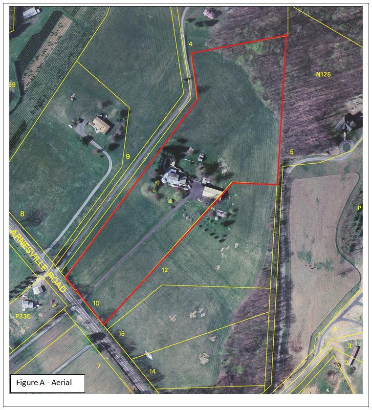
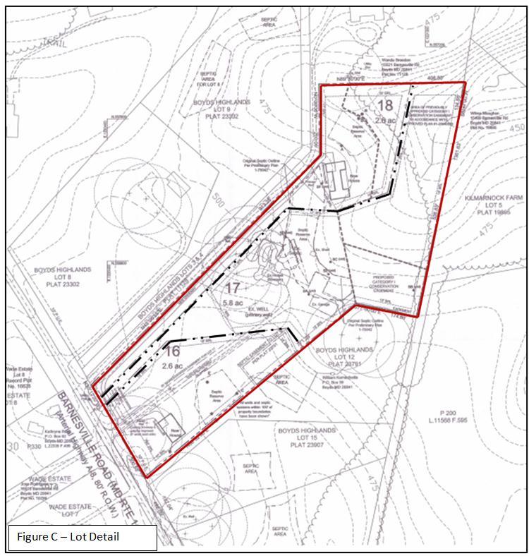
3 9) The certified Preliminary Plan must contain the following note: Unless specifically noted on this plan drawing or in the Planning Board conditions of approval, the building footprints, building heights, on-site parking, site circulation and sidewalks shown on the Preliminary Plan are illustrative. The final locations of buildings, structures and hardscape will be determined at the time if issuance of building permit(s). Please refer to the zoning data table for development standards such as setbacks, building restriction lines, building height and lot coverage for each lot. Other limitations for site development may also be included in the conditions of the Planning Board s approval. 10) The record plat must show existing and proposed Category 1 conservation easements and other necessary easements. 11) The Adequate Public Facility (APF) review for the Preliminary Plan will remain valid for eighty-five (85) months from the date of mailing of the Planning Board resolution. SITE DESCRIPTION The subject property is identified as Lot 10 on Plat No , Boyds Highlands. The acre Property is zoned RE-2 and is located on the north side of Barnesville Road (MD 117), approximately 950 feet southeast of Slidell Road, in the Boyds Master Plan area, ( Subject Property or Property ). The Property is improved with a one-family detached residence, a detached garage and shed, all of which will remain on the Property. Lots adjacent to the Property on the north side of Barnesville Road are also zoned RE-2 and most are improved with one-family detached dwellings. Properties located across Barnesville Road to the south are in the Rural Zone and most are improved with one family dwellings. The Property is located in the Little Seneca Creek Watershed, south of Little Seneca Lake. The Property has rolling topography and open fields maintained in lawn grass except for an area of trees located in the northeast corner. (See Figure A Aerial) PROJECT DESCRIPTION (See Figures B and C) The Application proposes a resubdivision of existing Lot 10, Boyds Highlands into three lots for three, one-family detached dwellings. As a subdivision of an existing lot shown on a record plat, the Application will be reviewed for compliance with the resubdivision criteria found in Section 50-29(b)(2) of the Subdivision Regulations. The existing driveway extending from Barnesville Road to the existing residence on the Property will be retained and used for access to all three proposed lots. A 30-foot wide ingress/egress and utility easement is proposed over the shared portions of the driveway. The entrance of the driveway will be improved to meet MDSHA requirements and it will be widened to 20 feet for a distance of 114 feet from Barnesville Road to meet Montgomery County Fire and Rescue Service (MCFRS) requirements. Proposed Lot 16 will be 2.6 acres in size; Lot 17, which is improved with the existing house and garage, will be 5.8 acres and Lot 18 will be 2.6 acres. The three proposed lots will be served by standard private septic systems and wells. 3
4 4

5 5 Figure B Preliminary Plan
6 6
7 ANALYSIS AND FINDINGS Conformance to the Master Plan The Application substantially conforms to the 1985 Boyds Master Plan ( Master Plan ). The Master Plan does not specifically identify the Subject Property but does provide general recommendations for zoning and land use. The Master Plan recommends RE-2 zoning along Barnesville Road as suitable, to create a definable edge for the RE-2 Zone and to create a more logical zoning transition from Clarksburg to Boyds (p.9). Residential land use at this density is considered appropriate due to the preferred use of septic systems in the general area. The Application complies with the recommendations adopted in the Master Plan and the proposed residential land use is on lots that meet the standards of the RE-2 zone. The Master Plan also recommends that Barnesville Road have an on road (signed) bikepath (SR 40). The State has the responsibility to place the required signage on this road in a comprehensive manner along the entire designated route. Adequate Public Facilities Roads and Transportation Facilities The lots do not generate 30 or more vehicle trips during the morning or evening peak-hours. Therefore, the Application is not subject to Local Area Transportation Review. The Application generates less than three new peak-hour trips; therefore, it is not subject to Policy Area Mobility Review. No sidewalks are required in this rural zone; pedestrians may use the road shoulder. With the improvements to the driveway at its entrance, vehicular and pedestrian access is safe and adequate. Other Public Facilities and Services The MCDPS Well and Septic Section have approved the on-site private wells and septic systems that will serve the three lots since public water and sewer is not extended to this area. Other public facilities and services, such as schools, police stations, firehouses and health clinics are currently operating within the standards set by the Subdivision Staging Policy in effect. The Property is within the Clarksburg High School cluster which is currently operating with no capacity limitations according to the FY13 Annual Schools Test. A School Facilities Payment is not required. Protection of Environmental Resources The Natural Resource Inventory/Forest Stand Delineation (NRI/FSD) # for the Property was approved on January 26, The NRI/FSD identified the Property s environmental constraints and forest resources. The Property is within the Little Seneca Creek watershed; a Use IV-P watershed. The Countywide Stream Protection Strategy (CSPS) rates streams in this section of the watershed as having good overall water quality. The Property contains no forest and has one tree between 24 and 30 diameter at breast (DBH), and no tree 30 DBH or greater. Topography is gently sloping from the southwest, down to the northeast where there is a stream with 1.53 acres of environmental buffer located in the northeast corner. The Application does not propose any impacts to the stream or the buffer. 7

8 Preliminary Forest Conservation Plan (See Figure D) Development of the Property generates a 2.20 acre afforestation planting requirement because the Property contains no existing forest and under the Medium Density Residential land use category, the Property has a 20 % afforestation threshold for the net tract area. The Applicant proposes to meet the planting requirement through a combination of 1.5 acres of off-site mitigation bank credits and 0.70 acres of onsite afforestation that will be protected in a Category I easement on proposed Lot 17. Sensitive environmental features on the Property are adequately protected and the Application complies with Chapter 22A, the Montgomery County Forest Conservation Law. Figure D Preliminary Forest Conservation Plan Stormwater Management In a memo dated February 23, 2009, the MCDPS Water Resources Section finds that the stormwater management concept for the site was acceptable under the provisions of the law at that time. Since then, the stormwater management regulations have been revised and this concept must be recertified by MCDPS. The approved stormwater management concept consists of on-site water quality control and onsite recharge via drywells and rooftop and non-rooftop disconnects. The use of these devices to control stormwater is likely to be unchanged in the recertification; however, staff has recommended a condition of approval to prohibit recordation of any record plat until the Applicant has obtained a letter from MCDPS recertifying the concept. 8
9 Compliance with the Subdivision Regulations and Zoning Ordinance This Application has been reviewed for compliance with the Montgomery County Code, Chapter 50, the Subdivision Regulations. The Application meets all applicable sections, including the requirements for resubdivision as discussed below. Based on review of the development pattern in the area of the Property and in consideration of the Master Plan recommendations, the size, width, shape and orientation of the lots are appropriate for the location of the subdivision. The lots were reviewed for compliance with the dimensional requirements for the RE-2 Zone as specified in the Zoning Ordinance. The lots meet all the dimensional requirements for area, frontage, width, and setbacks in that zone. A summary of this review is included in Table 1 below. The Application has been reviewed by other applicable county agencies, all of whom have recommended approval of the plan. 9
10 Conformance with Section 50-29(b)(2) A. Statutory Review Criteria In order to approve an application for resubdivision, the Planning Board must find that each of the proposed lots complies with all seven of the resubdivision criteria, set forth in Section 50-29(b)(2) of the Subdivision Regulations, which states: Resubdivision. Lots on a plat for the Resubdivision of any lot, tract or other parcel of land that is part of an existing subdivision previously recorded in a plat book shall be of the same character as to street frontage, alignment, size, shape, width, area and suitability for residential use as other lots within the existing block, neighborhood or subdivision. B. Neighborhood Delineation In administering Section 50-29(b)(2) of the Subdivision Regulations, the Planning Board must determine the appropriate neighborhood ( Neighborhood ) for evaluating the Application. In this instance, the Neighborhood selected by the Applicant, and agreed to by staff, consists of 22 lots (See Figure E). The Neighborhood includes all platted lots in the RE-2 Zone on the north side of Barnesville Road between Slidell Road and Ganley Road, and south of Little Seneca Lake. Certain properties that were intentionally excluded from the Neighborhood are unplatted parcels, approved but unplatted lots and properties not zoned RE-2. The 22 lot Neighborhood provides an adequate sample of the lot and development pattern of the area. A tabular summary of the lot comparison based on the resubdivision criteria is included (See Figure F). 10
11 Resubdivision Neighborhood Map Figure E 11

12 Figure F Comparison of the Character of Proposed Lots to Existing In performing the resubdivision analysis, the above-noted resubdivision criteria were applied to the delineated neighborhood. The proposed lots are of the same character with respect to the resubdivision criteria as other lots within the defined neighborhood. Therefore, the proposed resubdivision complies with the criteria of Section 50-29(b)(2). As set forth below, the attached tabular summary and graphical documentation support this conclusion: Frontage: Lot frontages in the Neighborhood range from 25 feet to 688 feet. The proposed lots fall within this range. Lot 16 has 233 feet of frontage, Lot 17 has 25 feet of frontage and Lot 18 has 40 feet of frontage. Twelve of the 22 lots in the Neighborhood have 25 feet of frontage (pipestems). 12
13 The proposed lots will be of the same character as existing lots in the Neighborhood with respect to lot frontage. Alignment: Fifteen of the existing lots in the Neighborhood are perpendicular in alignment to the roadway; seven are angled with one of these lots being a corner lot. The existing lots within the Neighborhood have a wide variation in alignment characteristics. The proposed lots are all aligned in a fairly perpendicular manner to the road and blend in well with the existing lots. The proposed lots are of the same character as existing lots with respect to the alignment criterion. Size: The existing lots in the Neighborhood range from 2.1 acres to 12.2 acres with a fairly even distribution of lots sizes within the range. The proposed lots range from 2.6 acres to 5.8 acres and are within the range for the lots in the Neighborhood. The proposed lot sizes are in character with the sizes of existing lots in the Neighborhood. Shape: Twelve lots have pipestems of which two are standard flag shaped, and the remaining ten lots having a more irregular shape. Other lots in the Neighborhood are also irregularly shaped and four are best described as rectangular. Lot 16 is an irregularly shaped lot and Lots 17 and 18 are pipestem lots with an irregular shape. The shapes of three proposed lots will be in character with shapes of the existing lots in the Neighborhood. Width: The width of the lots in the Neighborhood as measured at the front building line range from 150 feet to 496 feet. Lot 16, 17 and 18 have lot widths of 236 feet, 150 feet and 150 feet respectively. The proposed lots will be in character with existing lots in the Neighborhood with respect to width. Area: In the Neighborhood of 22 lots, lot area ranges from 1.1 acres to 9.8 acres in buildable area within building (zoning) setbacks. Proposed Lot 16 has a buildable area of 1.8 acres, Lot 17 has a buildable area of 3.3 acres and Lot 18 has a buildable area of 1.2 acres. The proposed lots will be of the same character as other lots in the Neighborhood with respect to buildable area. Suitability for Residential Use: The Property is zoned residential and there are no identified limitations with respect to the suitability of the Property for residential uses. 13
14 Citizen Correspondence and Issues This Application was submitted and noticed in accordance with all Planning Board adopted procedures. A sign referencing the proposed modification was posted along the Property frontage with Barnesville Road. (MD 117). A presubmission meeting was held at the Germantown Library on November 24, 2008 at 6:30 p.m. The meeting drew no attendees. As of the date of this report staff has not received any comments or correspondence regarding the Application. CONCLUSION Section 50-29(b)(2) of the Subdivision Regulations specifies seven criteria with which resubdivided lots must comply: street frontage, alignment, size, shape, width, area and suitability for residential use within the existing block, neighborhood or subdivision. As set forth above, the three proposed lots are of the same character as the existing lots in the defined neighborhood with respect to each of the resubdivision criteria, and therefore, comply with Section 50-29(b)(2) of the Subdivision Regulations. The proposed lots meet all other requirements established in the Subdivision Regulations and the Zoning Ordinance, and comply with the recommendations of the Master Plan. Access and public facilities will be adequate to serve the proposed lots, and the Application has been reviewed by other applicable county agencies, all of whom have recommended approval of the plan which are included as attachments. Therefore, approval of the Application with the conditions specified above is recommended. Attachments Attachment A Agency Correspondence 14
15 15 ATTACHMENT A
16 16 ATTACHMENT A
17 17 ATTACHMENT A
18 18
19 19 ATTACHMENT A
20 20 ATTACHMENT A
MONTGOMERY COUNTY PLANNING DEPARTMENT THE MARYLAND-NATIONAL CAPITAL PARK AND PLANNING COMMISSION
 MONTGOMERY COUNTY PLANNING DEPARTMENT THE MARYLAND-NATIONAL CAPITAL PARK AND PLANNING COMMISSION MCPB Item No.: Date: 06-21-12 The Plantations, Preliminary Plan -120090240 Benjamin Berbert, Senior Planner,
MONTGOMERY COUNTY PLANNING DEPARTMENT THE MARYLAND-NATIONAL CAPITAL PARK AND PLANNING COMMISSION
 MONTGOMERY COUNTY PLANNING DEPARTMENT THE MARYLAND-NATIONAL CAPITAL PARK AND PLANNING COMMISSION MCPB Item No. Date: 12/4/14 Preliminary Plan No. 120140200, Northwood Knolls Description Patrick Butler,
MONTGOMERY COUNTY PLANNING DEPARTMENT THE MARYLAND-NATIONAL CAPITAL PARK AND PLANNING COMMISSION
 MONTGOMERY COUNTY PLANNING DEPARTMENT THE MARYLAND-NATIONAL CAPITAL PARK AND PLANNING COMMISSION MCPB Item No. 8 Date: 03-07-13 Sonoma, Preliminary Plan, 120130040 Melissa Williams, Senior Planner, Melissa.williams@montgomeryplanning.org,
RECOMMENDATION: Approval subject to the following conditions:
 RECOMMENDATION: Approval subject to the following conditions: 1) Approval under this preliminary plan is limited to 2 lots for 2 dwelling units 2) The record plat must note that the preliminary plan is
MONTGOMERY COUNTY PLANNING DEPARTMENT THE MARYLAND-NATIONAL CAPITAL PARK AND PLANNING COMMISSION
 MONTGOMERY COUNTY PLANNING DEPARTMENT THE MARYLAND-NATIONAL CAPITAL PARK AND PLANNING COMMISSION MCPB Item No.: Date: 07-28-16 Lake Normandy Estates: Pre-Preliminary Plan No. 720160020 Ryan Sigworth AICP,
MONTGOMERY COUNTY PLANNING BOARD
 MONTGOMERY COUNTYPLANNING BOARD T H E MARYLAND-NATIONAL CAPITAL PARK A N D P L A N N I N G C O M M I S S I O N MCPB NO. 10-100 Preliminary Plan No. 120100210 Date of Hearing: July 1, 2010 MONTGOMERY COUNTY
MONTGOMERY COUNTY PLANNING DEPARTMENT THE MARYLAND-NATIONAL CAPITAL PARK AND PLANNING COMMISSION
 MONTGOMERY COUNTY PLANNING DEPARTMENT THE MARYLAND-NATIONAL CAPITAL PARK AND PLANNING COMMISSION MCPB Item No. Date: 1-17-13 Preliminary Plan 120110180 - Parmjit & Saini Estates Katherine Holt, Senior
MONTGOMERY COUNTY PLANNING DEPARTMENT THE MARYLAND-NATIONAL CAPITAL PARK AND PLANNING COMMISSION
 MONTGOMERY COUNTY PLANNING DEPARTMENT THE MARYLAND-NATIONAL CAPITAL PARK AND PLANNING COMMISSION MCPB Consent Item Date: 12/19/13 * Consent Item Barton Property: Preliminary Plan Amendment No. 12011021A
MONTGOMERY COUNTY PLANNING DEPARTMENT THE MARYLAND-NATIONAL CAPITAL PARK AND PLANNING COMMISSION
 MONTGOMERY COUNTY PLANNING DEPARTMENT THE MARYLAND-NATIONAL CAPITAL PARK AND PLANNING COMMISSION MCPB Item No. Date: 10-11-12 Subdivision Review Waiver SRW 2011001: Big Woods Road Richard Weaver, Acting
MONTGOMERY COUNTY PLANNING BOARD
 MONTGOMERY COUNTY PLANNING BOARD T H E MARYLAND-NATIONAL CAPITAL PARK A N D P L A N N I N G C O M M I S S I O N MCPB NO. 10-144 Hearing Date: September 30, 2010 MONTGOMERY COUNTY PLANNING BOARD RESOLUTION
MONTGOMERY COUNTY PLANNING BOARD
 APR :7 20m MONTGOMERY COUNTY PLANNING BOARD THE MARYLAND-NATIONAL CAPITAL PARK AND PLANNING COMMISSION MCPB No. 10-172 Date of Hearing: December 9, 2010 MONTGOMERY COUNTY PLANNING BOARD RESOLUTION WHEREAS,
MONTGOMERY COUNTY PLANNING DEPARTMENT THE MARYLAND-NATIONAL CAPITAL PARK AND PLANNING COMMISSION
 MONTGOMERY COUNTY PLANNING DEPARTMENT THE MARYLAND-NATIONAL CAPITAL PARK AND PLANNING COMMISSION MCPB Item No. 6 Date: 9-27-18 Seneca Farms, Preliminary Plan No. 120170240 Jonathan Casey, Senior Planner,
7-l MoNtcoupnv CouNtv PreNNrNc Boeno,I 'tne ITaRYLAND-NATIoNAL CAPITAL PARI< AND PLANNING con{n{ission
 7-l MoNtcoupnv CouNtv PreNNrNc Boeno,I 'tne ITaRYLAND-NATIoNAL CAPITAL PARI< AND PLANNING con{n{ission MCPB No. 16-023 Preliminary Plan No. '120160110 Date of Hearing: March 3, 2016 ltar 17 frft, RESOLUTlON
DANAC Stiles Property. Preliminary Plan A
 DANAC Stiles Property Preliminary Plan 11996112A Vicinity Located in the LSC North District of the GSSC Master Plan. Adjacent Uses North: Single-family attached townhouses, R-60 zone; East: Office building,
MONTGOMERY COUNTY PLANNING DEPARTMENT THE MARYLAND-NATIONAL CAPITAL PARK AND PLANNING COMMISSION
 MONTGOMERY COUNTY PLANNING DEPARTMENT THE MARYLAND-NATIONAL CAPITAL PARK AND PLANNING COMMISSION Wheaton Woods, Preliminary Plan No. 120160060 MCPB Item No. Date: 02-25-16 Lori Shirley, Planner Coordinator,
MONTGOMERY COUNTY PLANNING DEPARTMENT THE MARYLAND-NATIONAL CAPITAL PARK AND PLANNING COMMISSION
 MONTGOMERY COUNTY PLANNING DEPARTMENT THE MARYLAND-NATIONAL CAPITAL PARK AND PLANNING COMMISSION MCPB Item No. Date: 10-03-13 Preliminary Plan Amendment No. 11999034B Alvermar Woods, Lot 17 (In Response
Montgomery Village - South Valley Park: Subdivision Regulation Waiver SRW , and Site Plan No
 Montgomery Village - South Valley Park: Subdivision Regulation Waiver SRW - 201402, and Site Plan No. 820140070 12 SUBDIVISION REGULATION WAIVER RECOMMENDATION AND CONDITIONS OF APPROVAL Staff recommends
MONTGOMERY COUNTY PLANNING DEPARTMENT THE MARYLAND-NATIONAL CAPITAL PARK AND PLANNING COMMISSION
 MONTGOMERY COUNTY PLANNING DEPARTMENT THE MARYLAND-NATIONAL CAPITAL PARK AND PLANNING COMMISSION MCPB Item No. 3 Date: 05/28/15 Ingleside, Preliminary Plan No. 120140140 Ryan Sigworth AICP, Senior Planner
MONTGOMERY COUNTY PLANNING DEPARTMENT THE MARYLAND-NATIONAL CAPITAL PARK AND PLANNING COMMISSION
 MONTGOMERY COUNTY PLANNING DEPARTMENT THE MARYLAND-NATIONAL CAPITAL PARK AND PLANNING COMMISSION MCPB Item No. Date: 10-1-15 Chick-fil-A Olney: Preliminary Plan No. 120150180 and Site Plan No. 820150100
MONTGOMERY COUNTY PLANNING DEPARTMENT THE MARYLAND-NATIONAL CAPITAL PARK AND PLANNING COMMISSION
 MONTGOMERY COUNTY PLANNING DEPARTMENT THE MARYLAND-NATIONAL CAPITAL PARK AND PLANNING COMMISSION MCPB Item No. Date: 05-30-13 Pre-Preliminary Plan No. 720130040: Potomac Highlands Callum Murray, supervisor,
CREEKSIDE TOWNHOMES Chevy Chase, Maryland Site Plan No Preliminary Plan No
 +1 (301) 656 5901 info@nova-habitat.com CREEKSIDE TOWNHOMES Chevy Chase, Maryland Site Plan No. 820160050 Preliminary Plan No. 120160130 Application Statement of Justification October 28, 2015 Nova-Habitat,
WHEREAS, the staff of The Maryland-National Capital Park and Planning Commission recommended APPROVAL of the application with conditions; and
 R E S O L U T I O N WHEREAS, Redeemed Christian Church of God is the owner of a 2.83-acre parcel of land known as Lot 9, Lot 19, P/O Lot 1 and P/O Lot 18, Block B, Plat Book A, Plat 5, said property being
MONTGOMERY COUNTY PLANNING DEPARTMENT THE MARYLAND-NATIONAL CAPITAL PARK AND PLANNING COMMISSION
 MONTGOMERY COUNTY PLANNING DEPARTMENT THE MARYLAND-NATIONAL CAPITAL PARK AND PLANNING COMMISSION MCPB Item No. Date: 12/6/12 Limited Site Plan Amendment, 82000018D, DANAC Stiles Property, Lot 6 of Block
MONTGOMERY COUNTY PLANNING DEPARTMENT THE MARYLAND-NATIONAL CAPITAL PARK AND PLANNING COMMISSION
 MONTGOMERY COUNTY PLANNING DEPARTMENT THE MARYLAND-NATIONAL CAPITAL PARK AND PLANNING COMMISSION MCPB Item No. 5 Date: 12-15-16 Bradford s Landing, Preliminary Plan, 120170060 Description Sandra Pereira,
MONTGOMERY COUNTY PLANNING DEPARTMENT THE MARYLAND-NATIONAL CAPITAL PARK AND PLANNING COMMISSION
 MONTGOMERY COUNTY PLANNING DEPARTMENT THE MARYLAND-NATIONAL CAPITAL PARK AND PLANNING COMMISSION MCPB Item No.: 4 Date: 2-7-19 Old Angler s Cove, Preliminary Plan No. 120170290 Ryan Sigworth AICP, Senior
MONTGOMERY COUNTY PLANNING DEPARTMENT THE MARYLAND-NATIONAL CAPITAL PARK AND PLANNING COMMISSION
 MONTGOMERY COUNTY PLANNING DEPARTMENT THE MARYLAND-NATIONAL CAPITAL PARK AND PLANNING COMMISSION Ganassa Property, Preliminary Plan, 120040640 MCPB Item No. Date: 7-25-13 Callum Murray, Area 3 Supervisor,
MONTGOMERY COUNTY PLANNING DEPARTMENT THE MARYLAND-NATIONAL CAPITAL PARK AND PLANNING COMMISSION
 MONTGOMERY COUNTY PLANNING DEPARTMENT THE MARYLAND-NATIONAL CAPITAL PARK AND PLANNING COMMISSION MCPB Item No. Hearing Date: 10/8/15 Howard Hughes Medical Institute, Limited Amendment of the Preliminary
A. Location. A MRD District may be permitted throughout the County provided it meets the standards established herein.
 752. Multi-Residential District (MRD) The Multi-Residential (MRD) District is intended to provide opportunities for rural, suburban and urban density mixed-residential developments consistent with the
CITY OF FERNDALE HEARING EXAMINER
 CITY OF FERNDALE HEARING EXAMINER RE: Planned Unit Development ) 16001-PUD Preliminary Plat ) 16018-SE Plat Variance ) 16002-VAR Application by ) ) MD General, L.L.C. ) FINDINGS OF FACT, Malloy Heights
MONTGOMERY COUNTY PLANNING DEPARTMENT THE MARYLAND-NATIONAL CAPITAL PARK AND PLANNING COMMISSION
 MONTGOMERY COUNTY PLANNING DEPARTMENT THE MARYLAND-NATIONAL CAPITAL PARK AND PLANNING COMMISSION Colesville Senior Living Facility, Limited Preliminary Plan Amendment, 12016011A MCPB Consent Item Date:
MONTGOMERY COUNTY PLANNING DEPARTMENT THE MARYLAND-NATIONAL CAPITAL PARK AND PLANNING COMMISSION
 MONTGOMERY COUNTY PLANNING DEPARTMENT THE MARYLAND-NATIONAL CAPITAL PARK AND PLANNING COMMISSION MCPB Item Date: 06/01/17 900 Thayer Avenue: Project Plan Amendment No. 92005003B and Site Plan Amendment
SUBDIVISION DESIGN PRINCIPLES AND STANDARDS
 SECTION 15-200 SUBDIVISION DESIGN PRINCIPLES AND STANDARDS 15-201 STREET DESIGN PRINCIPLES 15-201.01 Streets shall generally conform to the collector and major street plan adopted by the Planning Commission
MONTGOMERY COUNTY PLANNING DEPARTMENT THE MARYLAND-NATIONAL CAPITAL PARK AND PLANNING COMMISSION
 MONTGOMERY COUNTY PLANNING DEPARTMENT THE MARYLAND-NATIONAL CAPITAL PARK AND PLANNING COMMISSION MCPB Consent Item Date: 11-2-17 Washington Adventist Hospital, Site Plan Amendment No. 82008021F Rhoda Hersson-Ringskog,
MONTGOMERY COUNTY PLANNING DEPARTMENT THE MARYLAND-NATIONAL CAPITAL PARK AND PLANNING COMMISSION
 MONTGOMERY COUNTY PLANNING DEPARTMENT THE MARYLAND-NATIONAL CAPITAL PARK AND PLANNING COMMISSION MCPB Item No. 4 Date: July 24, 2017 Claiborne: Preliminary Plan No. 120170250 and Site Plan No. 820170080
1 September 9, 2015 Public Hearing
 1 September 9, 2015 Public Hearing APPLICANT & PROPERTY OWNER: HOLLOMON- BROWN FUNERAL HOME, INC. STAFF PLANNER: Carolyn A.K. Smith REQUEST: Change of Zoning (R-5D Residential District to Conditional O-2
In order to permit maximum applicability of the PUD District, PUD-1 and PUD-2 Districts are hereby created.
 ARTICLE III. PUD ned Unit Development Overlay District 205-128. Purpose. The PUD ned Unit Development Overlay District is intended to provide flexibility in the design of planned projects; to encourage
B. The Plan is in conformity with the Comprehensive Plan.
 ARTICLE 17 PLANNING UNIT DEVELOPMENT 17.01 INTENT The purpose of this Section is to permit the creation of new Planned Unit Developments, permitted as Conditional Uses where maximum variations of design
Site Plan Application
 Site Plan Application City of St. Pete Beach Community Development Department 155 Corey Avenue St. Pete Beach, Florida 33706 (727) 367-2735 www.stpetebeach.org Case Number: PROPERTY OWNER: Name: Address:
MONTGOMERY COUNTY PLANNING DEPARTMENT THE MARYLAND-NATIONAL CAPITAL PARK AND PLANNING COMMISSION
 MONTGOMERY COUNTY PLANNING DEPARTMENT THE MARYLAND-NATIONAL CAPITAL PARK AND PLANNING COMMISSION MCPB Item No.: 5 Date: 09/29/2016 Washington Episcopal Day School: Preliminary Plan 120150160, Site Plan
ARTICLE V AGRICULTURAL PRESERVATION AND RURAL RESIDENTIAL DISTRICT
 ARTICLE V AP AGRICULTURAL PRESERVATION AND RURAL RESIDENTIAL DISTRICT Section 500. PURPOSE It is the purpose of the AP, Agricultural Preservation and Rural Residential District, to foster the preservation
Kitsap County Department of Community Development. Staff Report and Administrative Decision
 Kitsap County Department of Community Development Report Date: Staff Report and Administrative Decision Application Complete Date: March 19, 2018 Application Submittal Date: March 19, 2018 To: Seth Hanson,
Community Development Department 333 Broadalbin Street SW, P.O. Box 490 Albany, OR 97321
 SUMMARY Community Development Department 333 Broadalbin Street SW, P.O. Box 490 Albany, OR 97321 STAFF REPORT Application for Tentative Partition Plat Review Planning File PA-06-17 Phone: 541-917-7550
ARTICLE 23 CONDOMINIUM STANDARDS
 ARTICLE 23 CONDOMINIUM STANDARDS Section 23.01 Intent. The intent of this Article is to provide regulatory standards for condominiums and site condominiums similar to those required for projects developed
Article 7: Residential Land Use and Development Requirements
 Article 7: Residential Land Use and Section 701: Statement of Intent (A) (B) (C) The intent of Article 7 is to develop certain land use and development requirements for the residential uses within Cumru
Condominium Unit Requirements.
 ARTICLE 19 CONDOMINIUM REGULATIONS Section 19.01 Purpose. The purpose of this Article is to regulate projects that divide real property under a contractual arrangement known as a condominium. New and conversion
JUSTIFICATION STATEMENT FOR PRELIMINARY PLAN NO Preliminary Plan Justification for Chevy Chase Lake
 I. INTRODUCTION JUSTIFICATION STATEMENT FOR PRELIMINARY PLAN NO. 120150130 Preliminary Plan Justification for Chevy Chase Lake Applicant, CC Associates LLC (the Applicant ), by its attorneys, Linowes and
BEFORE THE HEARING EXAMINER FOR THURSTON COUNTY
 COUNTY COMMISSIONERS Cathy Wolfe District One Diane Oberquell District Two Robert N. Macleod District Three HEARING EXAMINER BEFORE THE HEARING EXAMINER FOR THURSTON COUNTY In the Matter of the Application
MONTGOMERY COUNTY PLANNING DEPARTMENT THE MARYLAND-NATIONAL CAPITAL PARK AND PLANNING COMMISSION
 MONTGOMERY COUNTY PLANNING DEPARTMENT THE MARYLAND-NATIONAL CAPITAL PARK AND PLANNING COMMISSION St. Andrews Episcopal School, Forest Conservation Plan Amendment, CBA 1389C (In response to violation) MCPB
Town of Cary, North Carolina Rezoning Staff Report 13-REZ-13 An Zou Property Town Council Meeting November 21, 2013
 Town of Cary, North Carolina Rezoning Staff Report 13-REZ-13 An Zou Property Town Council Meeting November 21, 2013 REQUEST To amend the Town of Cary Official Zoning Map by rezoning 0.63 acres located
FINAL DRAFT 12/1/16, Rev. to 7/18/17
 FINAL DRAFT 12/1/16, Rev. to 7/18/17 (As Adopted 8/8/17 Effective 9/1/17) SHELTON PLANNING AND ZONING COMMISSION Proposed Amendments to Zoning Regulations I. Amend Section 23 PERMITTED USES by inserting
BEAR CREEK TOWNSHIP EMMET COUNTY, MICHIGAN. PRIVATE ROAD ORDINANCE Ordinance No. 11A-99. (to replace prior Private Road Ordinance No.
 BEAR CREEK TOWNSHIP EMMET COUNTY, MICHIGAN PRIVATE ROAD ORDINANCE Ordinance No. 11A-99 (to replace prior Private Road Ordinance No. 11-99) An Ordinance to protect the health, safety, and general welfare
Sterling Meadow Subdivision
 Sterling Meadow Subdivision Proposal: A pre-application conference was held on November 7, 2017, with the applicant and City staff to discuss the development. The applicant took staff s recommendations
ARTICLE 13 CONDOMINIUM REGULATIONS
 ARTICLE 13 CONDOMINIUM REGULATIONS Section 13.01 Purpose. The purpose of this Article is to regulate projects that divide real property under a contractual arrangement known as a condominium. New and conversion
Open Space Model Ordinance
 Open Space Model Ordinance Section I. Background Open space development has numerous environmental and community benefits, including: 1) Reduces the impervious cover in a development. Impervious cover
VARIANCE PROCESS APPLICATION
 The Department is here to assist you with your development application pursuant to the Community Development Code (CDC). This publication outlines the Variance Process Development Application process of
BEFORE THE HEARING EXAMINER FOR THURSTON COUNTY
 COUNTY COMMISSIONERS Cathy Wolfe District One Diane Oberquell District Two Robert N. Macleod District Three HEARING EXAMINER BEFORE THE HEARING EXAMINER FOR THURSTON COUNTY In the Matter of the Application
Staff Report: Date: Applicant: Property Identification: Acreage of Request: Current Zoning of Requested Area: Requested Action: Attached:
 Staff Report: Completed by Jeff Palmer Director of Planning & Zoning Date: November 7, 2018, Updated November 20, 2018 Applicant: Greg Smith, Oberer Land Developer agent for Ronald Montgomery ET AL Property
a. It is the intent of these regulations to encourage the preservation of natural resources and facilitate orderly growth in the County.
 Part V Transfer of Development Rights Section 246. 1. Intent a. It is the intent of these regulations to encourage the preservation of natural resources and facilitate orderly growth in the County. b.
Draft Model Access Management Overlay Ordinance
 Draft Model Access Management Overlay Ordinance This model was developed using the City of Hutchinson and the Trunk Highway 7 corridor. The basic provisions of this model may be adopted by any jurisdiction
MONTGOMERY COUNTY PLANNING DEPARTMENT THE MARYLAND-NATIONAL CAPITAL PARK AND PLANNING COMMISSION
 MONTGOMERY COUNTY PLANNING DEPARTMENT THE MARYLAND-NATIONAL CAPITAL PARK AND PLANNING COMMISSION MCPB Item No. Date: 7-16-15 Travilah Grove, Preliminary Plan Amendment 12012029A, and Site Plan Amendment
Initial Project Review
 Pierce County Department of Planning and Land Services, 2401 South 35th Street, Tacoma, WA (253) 798-7037 Initial Project Review Major Amendment to Preliminary Plat: Hawks Ridge Division 1 Application
Planning Department Oconee County, Georgia
 Planning Department Oconee County, Georgia STAFF REPORT REZONE CASE #: 6985 DATE: October 31, 2016 STAFF REPORT BY: Andrew C. Stern, Planner APPLICANT NAME: Williams & Associates, Land Planners PC PROPERTY
610 LAND DIVISIONS AND PROPERTY LINE ADJUSTMENTS OUTSIDE A UGB
 ARTICLE VI: LAND DIVISIONS AND PROPERTY LINE ADJUSTMENTS VI-21 610 LAND DIVISIONS AND PROPERTY LINE ADJUSTMENTS OUTSIDE A UGB 610-1 Property Line Adjustments (Property Line Relocation) A property line
WESTMINSTER PARK PLACE SUBDIVISION
 WESTMINSTER PARK PLACE SUBDIVISION Engineering Comments: FINAL PLAT COMMENTS (should be addressed prior to submitting the FINAL PLAT for review and/or signature by the City Engineer): A. Provide all of
EXHIBIT D. Planned Unit Development Written Description April 13, 2016 Rouen Cove Phase II PUD
 1 EXHIBIT D Planned Unit Development Written Description April 13, 2016 Rouen Cove Phase II PUD Development # 8986.001 Developer: Curtis L. Hart Hart Resources LLC 8051 Tara Lane Jacksonville, Florida
PLANNING COMMISSION REPORT Regular Agenda -Public Hearing Item
 PDP-13-00518 Item No. 3B- 1 PLANNING COMMISSION REPORT Regular Agenda -Public Hearing Item PC Staff Report 2/24/14 ITEM NO. 3B PRELIMINARY DEVELOPMENT PLAN FOR HERE @ KANSAS; 1101 INDIANA ST (SLD) PDP-13-00518:
Request Subdivision Variance (Sections 4.4 (b) & (d) of the Subdivision Regulations) Staff Recommendation Approval. Staff Planner Jimmy McNamara
 & (d) of the Subdivision Regulations) Staff Recommendation Approval. Staff Planner Jimmy McNamara") Applicant & Property owner Titan Investment Group, Inc., a Virginia Corporation Public Hearing April 12, 2017 City Council Election District Kempsville Agenda Item 5 Request Subdivision Variance (Sections
Applicant & Property owner Titan Investment Group, Inc., a Virginia Corporation Public Hearing April 12, 2017 City Council Election District Kempsville Agenda Item 5 Request Subdivision Variance (Sections
Hamilton County Regional Planning Commission
 Hamilton County Regional Planning Commission March 1, 2012 Colerain Township Staff Report Zone Map Amendment: Case No.: ZA2012-01 Joseph Toyota Prepared By: Amy Bancroft, Land Use Planner ACTION REQUESTED:
Cover Letter with Narrative Statement
 Cover Letter with Narrative Statement March 31, 2017 rev July 27, 2017 RE: Rushton Pointe Residential Planned Unit Development Application for Public Hearing for RPUD Rezone PL2015 000 0306 Mr. Eric Johnson,
RC ; Reclassification The Garrison at Stafford Proffer Amendment (formerly Stafford Village Center)
") Board of Supervisors Robert Bob Thomas, Jr., Chairman Laura A. Sellers, Vice Chairman Meg Bohmke Jack R. Cavalier Wendy E. Maurer Paul V. Milde, III Gary F. Snellings Anthony J. Romanello, ICMA CM County
Board of Supervisors Robert Bob Thomas, Jr., Chairman Laura A. Sellers, Vice Chairman Meg Bohmke Jack R. Cavalier Wendy E. Maurer Paul V. Milde, III Gary F. Snellings Anthony J. Romanello, ICMA CM County
MONTGOMERY COUNTY PLANNING DEPARTMENT THE MARYLAND-NATIONAL CAPITAL PARK AND PLANNING COMMISSION
 MONTGOMERY COUNTY PLANNING DEPARTMENT THE MARYLAND-NATIONAL CAPITAL PARK AND PLANNING COMMISSION MCPB Item No. xxxxx Date: 6-7-12 Hoyt Property, Preliminary/Site Plan, 120120140/820120070 Tina Schneider,
Section Intent
 Section 246. 1. Intent 2. Authority a. It is the intent of these Transfer of Development Rights (TDR s) regulations to encourage the preservation of natural resources and facilitate orderly growth in the
TULSA PARK ESTATES SUBDIVISION, RESUBDIVISION OF LOT 6
 TULSA PARK ESTATES SUBDIVISION, RESUBDIVISION OF LOT 6 Engineering Comments: FINAL PLAT COMMENTS (should be addressed prior to submitting the FINAL PLAT for review and/or signature by the City Engineer):
Community Development
 Land Use Petition RZ-15-010 Concurrent Variance VC-15-010-01 Date of Staff Recommendation Preparation: August 14, 2015 Date of Planning Commission Recommendation: September 1, 2015 PROJECT LOCATION: DISTRICT/SECTION/LANDLOT(S):
Article Optional Method Requirements
 Article 59-6. Optional Method Requirements [DIV. 6.1. MPDU DEVELOPMENT IN RURAL RESIDENTIAL AND RESIDENTIAL ZONES Sec. 6.1.1. General Requirements... 6 2 Sec. 6.1.2. General Site and Building Type Mix...
MONTGOMERY COUNTY PLANNING DEPARTMENT
 MONTGOMERY COUNTY PLANNING DEPARTMENT THE MARYLAND-NATIONAL CAPITAL PARK AND PLANNING COMMISSION Forest Conservation Law Amendments - Modifications MCPB Item No. 7 Date: 5/24/2018 SUMMARY Mark Pfefferle,
Draft Zoning Changes for the 2nd Planning Board Public Hearing, January 22, 2018.
 Draft Zoning Changes for the 2nd Planning Board Public Hearing, January 22, 2018. No changes were made at the 1st Public Hearing. Proposed wording for the 1 st Public Hearing in red, eliminated text in
DISTRICT COUNCIL FOR PRINCE GEORGE S COUNTY, MARYLAND OFFICE OF ZONING HEARING EXAMINER SPECIAL EXCEPTION 4658 DECISION
 DISTRICT COUNCIL FOR PRINCE GEORGE S COUNTY, MARYLAND OFFICE OF ZONING HEARING EXAMINER SPECIAL EXCEPTION 4658 DECISION Application: Three Chair Barber Shop Applicants: Danta L. & Felicia B. Wright/Fort
Conditional Use Permit case no. CU 14-06: Bristol Village Partners, LLC
 PLANNING AND ZONING COMMISSION STAFF REPORT August 7, 2014 Conditional Use Permit case no. CU 14-06: Bristol Village Partners, LLC CASE DESCRIPTION: LOCATION: LEGAL DESCRIPTION: EXISTING LAND USE: ZONING:
Financial Impact Statement There are no immediate financial impacts associated with the adoption of this report.
 STAFF REPORT Planning and Development Department Subject: Application by RYC Property to rezone a portion of lands on John Murray Dr. and Megan Lynn Dr. from R2 to R3 and to enter into a Development Agreement
Chapter Planned Residential Development Overlay
 Chapter 19.29 Planned Residential Development Overlay Sections 010 Purpose 020 Scope 030 Definitions 030 Minimum Size 040 Allowable Uses 050 Minimum Development Standards 060 Density Bonus 070 Open Space
M-43 CORRIDOR OVERLAY ZONE
 ARTICLE 26.00 M-43 CORRIDOR OVERLAY ZONE Section 26.01 Findings A primary function of the M-43 state highway is to move traffic through the Township and to points beyond. As the primary east-west arterial
CONDOMINIUM REGULATIONS
 ARTICLE 37 CONDOMINIUM REGULATIONS SECTION 37.01. Purpose The purpose of this Article is to regulate projects that divide real property under a contractual arrangement known as a condominium. New and conversion
204 Minor Subdivision & Large Lot Division
 204 Minor Subdivision & Large Lot Division 204.01 Purpose and Intent 204.05 General Procedures 204.10 Large Lot Division 204.02 Comprehensive Land Use 204.06 Submittal Requirements Plan Policies 204.07
Exhibit D. Tallow Ridge PUD. Written Description. Date: January 5, E. City Development Number:
 Exhibit D Tallow Ridge PUD Written Description Date: January 5, 2016 I. SUMMARY DESCRIPTION OF THE PROPERTY A. Current Land Use Designation: RR B. Current Zoning District: PUD C. Requested Zoning District:
PGCPB No File No R E S O L U T I O N
 R E S O L U T I O N WHEREAS, Jemal s Calvert II, LLC is the owner of a 1.69-acre parcel of land known as Greenhorne & O Mara s Addition to Riverdale Gardens, Parcel 1, said property being in the 19th Election
Town of Cary, North Carolina Site Plan Staff Report Centregreen Park at Weston (13-SP-067) Town Council Quasi-Judicial Hearing April 3, 2014
 Town Council Quasi-Judicial Hearing April 3, 2014") Town of Cary, North Carolina Site Plan Staff Report Centregreen Park at Weston (13-SP-067) Town Council Quasi-Judicial Hearing April 3, 2014 REQUEST Withers and Ravenel, on behalf of Highwoods Realty Limited
Town of Cary, North Carolina Site Plan Staff Report Centregreen Park at Weston (13-SP-067) Town Council Quasi-Judicial Hearing April 3, 2014 REQUEST Withers and Ravenel, on behalf of Highwoods Realty Limited
FOR OFFICE USE ONLY Date Submitted Received By Fees Paid $ Receipt No. Received By Application No. Application Complete Final Action Date
 COMMERCIAL, INDUSTRIAL, & MANUFACTURING SITE PLAN (CIM) APPLICATION Mariposa County Planning Department 5100 Bullion Street, P.O. Box 2039 Mariposa, CA 95338 Telephone (209) 966-5151 FAX (209) 742-5024
STATE OF MICHIGAN COUNTY OF BERRIEN ORONOKO CHARTER TOWNSHIP PRIVATE ROAD ORDINANCE ORDINANCE NO. 65
 STATE OF MICHIGAN COUNTY OF BERRIEN ORONOKO CHARTER TOWNSHIP PRIVATE ROAD ORDINANCE ORDINANCE NO. 65 AN ORDINANCE TO REQUIRE THAT ALL LOTS OR PARCELS OF LAND WHICH DO NOT ABUT PUBLIC STREETS ABUT A PRIVATE
the conditions contained in their respective Orders until January 1, 2025, at the discretion of the Director of Planning, Property and Development.
 Part 4: Use Regulations Temporary Uses and Structures Purpose the conditions contained in their respective Orders until January 1, 2025, at the discretion of the Director of Planning, Property and Development.
4. facilitate the construction of streets, utilities and public services in a more economical and efficient manner;
 PVPC MODEL BYLAW BY-RIGHT CLUSTER ZONING BYLAW Prepared by Pioneer Valley Planning Commission Revised: October 2001 1.00 Development 1.01 Development Allowed By Right Development in accordance with this
Time Extension Staff Report
 Time Extension Staff Report Subdivision Name Lunara Subdivision File Number SUB07-00019 Approval Time Extension for Lead Agency Boise City Certification Signature of Boise City Engineer Annexation Date
STAFF REPORT. Permit Number: Gonzalez. Kitsap County Board of Commissioners; Kitsap County Planning Commission
 STAFF REPORT Permit Number: 15 00657 Gonzalez DATE: March 2, 2016 TO: FROM: Kitsap County Board of Commissioners; Kitsap County Planning Commission Katrina Knutson, AICP, Senior Planner, DCD and Jeff Arango,
ARTICLE IV: DEVELOPMENT STANDARDS
 ARTICLE IV: DEVELOPMENT STANDARDS IV-53 409 PRIVATE STREETS A private street means any way that provides ingress to, or egress from, property by means of vehicles or other means, or that provides travel
FINAL SPUD APPLICATION
 The Planning & Development Services Department is here to assist you with your development application pursuant to the Community Development Code (CDC). This publication outlines the Final SPUD Development
CHAPTER 50 MONTGOMERY COUNTY SUBDIVISION REGULATIONS PLANNING BOARD DRAFT July 31, 2015
 CHAPTER 50 MONTGOMERY COUNTY SUBDIVISION REGULATIONS PLANNING BOARD DRAFT July 31, 2015 Chapter 50: Subdivision Regulations Page Intentionally Blank Chapter 50: Subdivision Regulations TABLE OF CONTENTS
CHAPTER 50 MONTGOMERY COUNTY SUBDIVISION REGULATIONS
 CHAPTER 50 MONTGOMERY COUNTY SUBDIVISION REGULATIONS Effective February 13, 2017 Sec. 3. Effective Date. This amendment takes effect on February 13, 2017. The amendment applies to any Planning Board action
EAST GOSHEN TOWNSHIP CHESTER COUNTY, PENNSYLVANIA ORDINANCE NO.
 EAST GOSHEN TOWNSHIP CHESTER COUNTY, PENNSYLVANIA ORDINANCE NO. AN ORDINANCE AMENDING THE EAST GOSHEN TOWNSHIP ZONING ORDINANCE OF 1997, AS AMENDED, WHICH IS CODIFIED IN CHAPTER 240 OF THE EAST GOSHEN
Chapter Plat Design (LMC)
") Chapter 18.14 Plat Design (LMC) Sections: 18.14.010 Lot width 18.14.020 Right-of-way requirements 18.14.030 Pipe stem lots 18.14.040 Division resulting in minimum lot sizes 18.14.050 Flood prone and bad
Chapter 18.14 Plat Design (LMC) Sections: 18.14.010 Lot width 18.14.020 Right-of-way requirements 18.14.030 Pipe stem lots 18.14.040 Division resulting in minimum lot sizes 18.14.050 Flood prone and bad
DAUPHIN CREEK ESTATES SUBDIVISION
 # 12 SUB-000076-2017 DAUPHIN CREEK ESTATES SUBDIVISION Engineering Comments: FINAL PLAT COMMENTS (should be addressed prior to submitting the FINAL PLAT for review and/or signature by the City Engineer):