MONTGOMERY COUNTY PLANNING DEPARTMENT THE MARYLAND-NATIONAL CAPITAL PARK AND PLANNING COMMISSION
|
|
|
- Cleopatra Anthony
- 5 years ago
- Views:
Transcription

1 MONTGOMERY COUNTY PLANNING DEPARTMENT THE MARYLAND-NATIONAL CAPITAL PARK AND PLANNING COMMISSION MCPB Item No. Date: Chick-fil-A Olney: Preliminary Plan No and Site Plan No Jonathan Casey, Senior Planner, Area 3 Jonathan.Casey@montgomeryplanning.org Calvin Nelson, Jr., Planner Coordinator, Area 3 Calvin.Nelson@montgomeryplanning.org Richard Weaver, Supervisor, Area 3 Richard.Weaver@montgomeryplanning.org Fred Boyd, Acting Chief, Area 3 Fred.Boyd@montgomeryplanning.org Description Completed: 09/18/15 A. Chick-fil-A Olney: Preliminary Plan No Request for one lot to construct a 4,886 square-foot restaurant and drive-thru, located at Georgia Avenue, east side, north of the intersection of Georgia Avenue and Olney-Sandy Spring Road, 0.90 acres, zoned CRT 2.0, C-1.0, R-1.0, H-70T; Olney Master Plan. Staff Recommendation: Approval with Conditions B. Chick-fil-A Olney: Site Plan No Request for site plan approval for a 4,886 square-foot restaurant and drive-thru, located at Georgia Avenue, east side, north of the intersection of Georgia Avenue and Olney-Sandy Spring Road, 0.90 acres, zoned CRT 2.0, C-1.0, R-1.0, H-70T; Olney Master Plan. Staff Recommendation: Approval with Conditions Applicant: John Martinez Submittal Date: May 12, 2015 Review Basis: Chapter 50, Chapter 59 Summary Staff recommends approval of Preliminary Plan No , and Site Plan No with conditions. The Application meets the requirements of the CRT zone under the standard method of development. The Applicant proposes to redevelop the subject property by replacing an existing commercial building with a 4,886 square-foot restaurant with a drive-thru. The Application is exempt from forest conservation. A drive-thru is a limited use in the CRT zone and requires site plan approval in addition to preliminary plan. Staff has not received correspondence from notified parties.
2 TABLE OF CONTENTS SECTION 1: CONTEXT AND PROPOSAL Site Description Project Description Community Outreach SECTION 2: PRELIMINARY PLAN Recommendations and Conditions Analysis and Findings Conformance to the Master Plan Site Access, Parking and Public Transportation Adequate Public Facilities Master Plan Transportation Facilities Other Public Facilities and Services Environment Compliance with the Subdivision Regulations and Zoning Ordinance SECTION 3: SITE PLAN Recommendations and Conditions Site Plan Proposal Limited Use Findings for a Drive-Thru in the CRT Zone Site Plan Analysis and Findings CONCLUSION ATTACHMENTS 1. Preliminary Plan 2. Interparcel connection agreement 3. Forest Conservation Plan Exemption confirmation letter dated October 31, Stormwater Management Concept letter dated May 28, Site Plan 6. Statement of Justification from the Applicant 7. Maryland State Highway Administration letter dated July 10, Montgomery County Department of Transportation letter dated June 30, Montgomery County Department of Permitting Services letter dated May 28, Need Study: Chick-fil-A Restaurant with Drive-Thru dated October, Regulatory Plan Extension Request dated August 14,
 and consists of a 0.90-acre parcel (P957, Tax Map HT563) zoned CRT 2.0, C-1.0, R-1.0, H-70T ( Property or Subject Property ).")
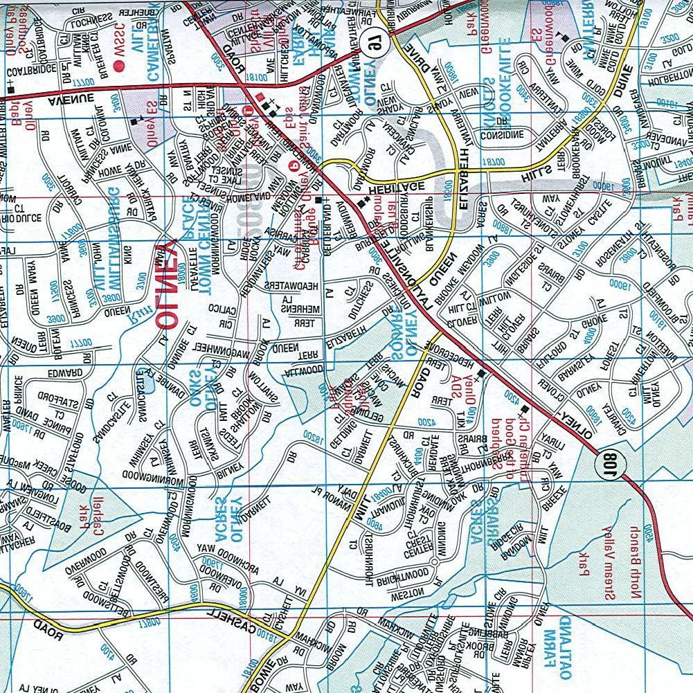
3 SECTION 1: CONTEXT AND PROPOSAL SITE DESCRIPTION The subject property is located at Georgia Avenue (MD 97), east side, north of the intersection of Georgia Avenue and Olney Sandy Spring Road (MD 108) and consists of a 0.90-acre parcel (P957, Tax Map HT563) zoned CRT 2.0, C-1.0, R-1.0, H-70T ( Property or Subject Property ). The Subject Property is within the Town Center district of the 2005 Olney Master Plan ( Master Plan ). The Subject Property fronts on Georgia Avenue, within a block bounded by Georgia Avenue on the west, Olney Sandy Spring Road on the south, and Hillcrest Avenue to the north and east. The land uses within this block consist of a medical office building to the north, a retail building to the northeast, a commercial building which houses two walk-in restaurants, an office to the south, and a freestanding financial office building to the southeast. The parking for adjacent office and commercial use is located along the northern, eastern and southern boundaries of the Property. Figure 1: Vicinity Map 3

4 The Subject Property is improved with a three-story commercial building and associated asphalt and gravel surface parking. The existing building, built in 1955, contains approximately 7,920 square feet of gross floor area, and contains a dry cleaner, karate studio and other commercial uses. The Property is currently served by a private well and septic system. The Property is accessible from two points on Georgia Avenue, with the southern access being a shared access with the adjacent commercial property, separated by a moveable concrete barrier. A narrow landscape strip with two street trees separates the northern and southern access points on Georgia Avenue. Along the entire frontage of the Property is a 6 foot wide sidewalk which abuts the existing curb. A relatively large open green area exists on the northeast quadrant of the Property. Approximately 64 percent of the 0.90 net lot area is currently impervious. The Subject Property is located within the Patuxent River watershed; this portion of the watershed is classified by the State of Maryland as Use Class IV-P waters. The Property is not located within a Special Protection Area; however, a portion of the Property is located within the Patuxent River Primary Management Area (PMA). There are no streams, wetlands, 100-year floodplains, or environmental buffers located on or adjacent to the Property, nor are there any steep slopes, highly erodible soils, or forests. PROJECT DESCRIPTION Figure 2: Proposed Development Preliminary plan application No ( Preliminary Plan ) proposes to subdivide Parcel 957 consisting of 0.90 acres (39,420 sq. ft.) to create a single lot for a Chick-fil-A restaurant and drive-thru (Attachment 1). The Property has frontage on Georgia Avenue, a public road, which will serve as access to the lot. The lot will also be accessible from the existing parking lot on the adjacent Property to the 4
5 east (Attachment 2). The existing building will be demolished and replaced with a 4,886 square foot restaurant and a single drive-thru with dual ordering kiosks. The existing access to Georgia Avenue will be removed and a single right-in right-out driveway will be constructed on the northern half of the Property. The proposed restaurant will connect to new public water and sewer extensions. The existing well and septic system will be removed in accordance with Montgomery County Department of Environmental Protection ( MCDEP ) and Montgomery County Department of Permitting Services ( MCDPS ) requirements. Stormwater quantity and quality will be managed on lot via 4 microbioretention facilities and an underground detention/structural filtration facility. Community Outreach The Applicant has met all proper signage, noticing, and submission requirements. Staff has not received correspondence on either application. The Applicant held a pre-submission meeting on November 19, 2014, and a second pre-submission on March 23, In addition to these meetings, Chick-fil-A has met with community groups, including the Olney Town Center Advisory Committee and the Greater Olney Civic Association. Recommendations from these meetings resulted in substantial changes to the plans prior to the submission on May 12, SECTION 2: PRELIMINARY PLAN No STAFF RECOMMENDATION: Approval of the Preliminary Plan, with the following conditions: 1. This Preliminary Plan is limited to one lot for a 4,886 square foot restaurant and single drive thru. 2. The Planning Board accepts the recommendations of the Montgomery County Department of Transportation ( MCDOT ) in its letter dated June 30, 2015, and hereby incorporates them as conditions of the Preliminary Plan approval. The Applicant must comply with each of the recommendations as set forth in the letter, which may be amended by MCDOT provided that the amendments do not conflict with other conditions of the Preliminary Plan approval. 3. Prior to recordation of plat(s), the Applicant must satisfy the provisions for access and improvements as required by MCDOT. 4. The Planning Board accepts the recommendations of the Maryland State Highway Administration ( MDSHA ) in its letter dated July 10, 2015, and hereby incorporates them as conditions of the Preliminary Plan approval. The Applicant must comply with each of the recommendations as set forth in the letter, which may be amended by MDSHA provided that the amendments do not conflict with other conditions of the Preliminary Plan approval. 5. Prior to issuance of access permits, the Applicant must satisfy the provisions for access and improvements as required by MDSHA. 6. The Planning Board accepts the recommendations of the Montgomery County Department of Permitting Service ( MCDPS ) Water Resources Section in its stormwater management concept letter dated May 28, 2015, and hereby incorporates them as conditions of the Preliminary Plan approval. The Applicant must comply with each of the recommendations as set forth in the letter, which may be amended by MCDPS Water Resources Section provided that the amendments do not conflict with other conditions of the Preliminary Plan approval. 5
6 7. The Applicant must dedicate and show on the record plat(s) the dedication for Georgia Ave (MD 97) as shown on the Preliminary Plan. 8. The Applicant must construct all road improvements within the rights-of-way shown on the approved Preliminary Plan to the full width mandated by the master plan and/or to the design standards imposed by all applicable road codes. Only those roads (or portions thereof) expressly designated on the Preliminary Plan, To Be Constructed By are excluded from this condition. 9. The Subject Property is limited to one right-in/right-out access to Georgia Avenue (MD 97) and must be approved by Maryland State Highway Administration (MDSHA). 10. The Applicant must dedicate and show on the record plat, right-of-way to allow for the construction of a 10-foot shared use path as shown on the Preliminary Plan. 11. Prior to recordation of the plat(s), the Applicant must satisfy Montgomery County Department of Permitting Services (MCDPS) requirements to ensure the following pedestrian improvement: a. Construct a 10-foot wide shared use path along entire property frontage on Georgia Avenue (MD 97) and provide necessary crosswalks and ramps, in the location shown on the Preliminary Plan. 12. Prior to the issuance of a Use and Occupancy Certificate, the Applicant must: a. Construct an 8-foot wide lead-in sidewalk with stairs from Georgia Avenue (MD 97) to the sidewalk on the west side of the building. b. Provide and have inter-parcel access open to vehicle and pedestrian traffic with the property to the east as shown on the Preliminary Plan. 13. The certified Preliminary Plan must contain the following note: Unless specifically noted on this plan drawing or in the Planning Board conditions of approval, the building footprints, building heights, on-site parking, site circulation, and sidewalks shown on the Preliminary Plan are illustrative. The final locations of buildings, structures and hardscape will be determined at the time of site plan approval. Please refer to the zoning data table for development standards such as setbacks, building restriction lines, building height, and lot coverage for each lot. Other limitations for site development may also be included in the conditions of the Planning Board s approval. 14. Final approval of location of buildings, on-site parking, site circulation, sidewalks, and shareduse paths will be determined at Site Plan. 15. The record plat must show necessary easements. 16. The record plat must reflect a public use and access easement over all private streets and adjacent parallel sidewalks. 17. The Adequate Public Facility ( APF ) review for the Preliminary Plan will remain valid for eightyfive (85) months from the date of mailing of this Planning Board Resolution. 6
7 18. Prior to recordation of any plat, Site Plan No must be certified by M-NCPPC Staff. 19. No clearing or grading of the site, or recording of plats prior to certified site plan approval. 20. In the event that a subsequent site plan approval substantially modifies the subdivision shown on the approved Preliminary Plan with respect to lot configuration or location or right-of-way width, or alignment, the Applicant must obtain approval of a Preliminary Plan amendment prior to certification of the site plan. ANALYSIS AND FINDINGS Chapter 50 Conformance to the Master Plan The Subject Property is located in Olney s Town Center shown in Figure 3 below. The 2005 Olney Master Plan recognized that Olney s Town Center could function as both a civic and commercial focus for Olney s communities. The Master Plan focused considerable attention on the Town Center, setting as an overall goal the creation of an economically healthy, pedestrian-oriented, and well connected Town Center to be the commercial and civic heart of the community. (p 45) To achieve this goal, the Master Plan proposed a new Mixed Use Town Center Zone that would enable residential uses to be integrated in the Town Center and create a more compact pattern of development with a pedestrian orientation. The new zone was put in place, and, as part of the county s comprehensive revision of its zoning ordinance, Olney s Town Center is now in the Commercial/Residential Town (CRT) Zone. 7

8 Figure 3: Town Center Context 8
9 The Master Plan included urban design recommendations for the town center, which were designed to implement the development pattern, activate shopping streets and encourage pedestrian activity. The Master Plan sought buildings located close to streets; façades, entrances and storefronts that would enliven the streetscape; wider sidewalks; and public amenities. The Application substantially conforms with those recommendations. The proposed building is located directly on Georgia Avenue, activates the frontage, is significantly landscaped, and offers seating for patron use. There are windows and awnings along the façade, as well as a door from the restaurant to the seating area. This treatment will contribute to a streetscape conducive to increased pedestrian activity. The Applicant, a national restaurant chain, has made a serious effort to design a building that will be integrated into a town center that is active, walkable and connected. The proposed use and lot substantially conforms with the recommendations adopted in the Olney Master Plan. Site Access, Parking, and Public Transportation The Subject Property is located at the northeast corner of Olney Sandy Spring Road (MD 108) and Georgia Avenue (MD 97). Access to the site is currently from two right-in/right-out entrances along Georgia Avenue. The Applicant proposes to close the right-in/right-out entrance that is closest to MD 108 and provide inter-parcel access with the property to the east that will create a connection from Georgia Avenue to Hillcrest Avenue. Vehicle parking will be provided on-site with surface parking spaces and bicycle parking will be provided with an inverted U-rack placed near the main entrance of the building. The Applicant will construct a ten-foot shared use path along the Property frontage of northbound Georgia Avenue as indicated in the Countywide Bikeways Functional Master Plan. Additionally, the Applicant proposes to construct a lead sidewalk and stairs that will provide a direct connection from the proposed shared use path on Georgia Avenue to their building. Ride-on Route 52 and 53 and Washington Metropolitan Area Transit Authority (WMATA) Route Y2 and Y8 provide bus service within close proximity of the Subject Property. WMATA Route Y2 and Y8 connect the Medstar Montgomery Medical Center to the Silver Spring Metrorail station by way of Olney Sandy Spring Road and Georgia Avenue. The Y2 runs during the morning and afternoon peak periods and in the evening with service every 30 minutes. The route also runs on the weekend with service every 30 minutes. The Y8 Route runs during Monday through Friday during the midday with service every 30 minutes. Ride-On Route 52 connects Montgomery General Hospital to the Rockville Metrorail station with service every 30 minutes in the peak direction during the peak period Monday through Friday. Ride-On Route 53 connects the Shady Grove Metrorail station to the Glenmont Metrorail Station by way of Olney Sandy Spring Road with service every 30 minutes in the peak period Monday through Friday. The closest bus stop is located approximately 150 feet north of the Subject Property on Georgia Avenue for Route 53. The closest southbound bus stop that serves all routes is located approximately 250 feet south of the Property on Georgia Avenue across Olney Sandy Spring Road. 9
 review.")

10 Adequate Public Facilities Review (APF) As conditioned, the Preliminary Plan for the proposed 4,886 square foot restaurant and drive-thru will satisfy the LATR and TPAR requirements of the Adequate Public Facilities (APF) review. Trip Generation The peak-hour trip generation estimated for the proposed development was based on trip generation rates included in the Institute of Transportation Engineers (ITE) Trip Generation Manual, 9 th edition. A site trip generation summary is presented in Table 1, which shows that the proposed development would generate a total of 37 net new peak-hour trips during weekday morning peak period and 3 fewer peak-hour trips during weekday evening peak period after the pass-by, diverted trips, and existing use reductions are taken into account. A pass-by trip reduction is assumed because traffic is already using the adjacent roadway and enters the site as intermediate stop on their way to, or from, another destination. A diverted trip reduction is taken as these vehicles are already on the road network, but these trips are making out of directional travel to access the proposed use. They are on the road network already but choose to make additional turns or go out of their typical travel pattern to access the Subject Property. As such, if these trips are added back into the net total trips, the proposed use will generate an additional 99 trips in the morning peak hour and 34 new trips in the afternoon peak hour. This increase in number of trips will not increase the CLVs at the intersections to the point where they will fall below the acceptable CLV threshold. Table 1: Site Trip Generation Local Area Transportation Review (LATR) A traffic study dated March 23, 2015, was submitted to determine the impact of the proposed development on the area transportation system. Six local intersections were identified as critical intersections for analysis to determine whether they meet the applicable congestion standard. All six are located in the Olney Policy Area with a Critical Lane Volume (CLV) standard of 1,450. Two of the six intersections, Olney Sandy Spring Road/Georgia Avenue and Olney Sandy Spring Road/Shopping Center Driveway, evaluated in the traffic impact study are currently signalized. The Property will have one right-in/right-out only access to Georgia Avenue. The Georgia Avenue/Five Guys driveway egress only will not provide any access for the Subject Property. 10
11 The proposed development trips were added to the existing and the background traffic (trips generated from approved but unbuilt developments) to determine the total future traffic. The total future traffic was assigned to the critical intersections to evaluate the total future CLVs. The result of CLV calculation is shown in the Table 2 below. As shown in the table, all intersections analyzed are currently operating at acceptable CLV congestion standards and will continue to do so under the background development condition, and total future traffic condition with the proposed use on the Subject Property. Table 2: Summary of Critical Lane Volume (CLV) Calculations Critical Lane Volume Existing Traffic Background Traffic Total Future Traffic Intersection (CLV) Standard AM PM AM PM AM PM Georgia Avenue (MD 97) & Hillcrest CLV Standard 1, Avenue Exceed CLV no no no no no no Georgia Avenue (MD 97) & Main Site Entrance Georgia Avenue (MD 97) & Driveway for Five Guys Restaurant Georgia Avenue (MD 97) & Olney Sandy Spring Road (MD 108) Olney Sandy Spring Road & Hillcrest Avenue Olney Sandy Spring Road (MD 108) & Shopping Center Driveway Transportation Policy Area Review (TPAR) CLV Standard 1, Exceed CLV no no no no no no CLV Standard 1, Exceed CLV no no no no no no CLV Standard 1,450 1,063 1,147 1,083 1,185 1,096 1,204 Exceed CLV no no no no no no CLV Standard 1, Exceed CLV no no no no no no CLV Standard 1, Exceed CLV no no no no no no The Property is located in the Olney Policy Area. According to the Subdivision Staging Policy, the Olney Area is adequate under the roadway test but inadequate under the transit test. The Montgomery County Department of Permitting Services assesses the transportation impact tax based on square footage increase. Even though the change in use will generate 37 additional trips in the AM peak hour, the Applicant is reducing the square footage of the building; therefore, no TPAR payment is required. Master Plan Transportation Facilities The 2005 Approved and Adopted Olney Master Plan and 2005 Countywide Bikeways Functional Master Plan contain the following recommendations for adjacent roadway/bikeway facilities: Georgia Avenue (MD 97): A major highway (M-8) with four divided travel lanes (two lanes in each direction with a median) with a right-of-way of 120 feet. Sufficient right-of-way is being dedicated to implement all of the transportation elements that are identified in the Olney Master Plan. An off-road shared-use path (SP-39) on Georgia Avenue in front of the Subject Property. The Preliminary Plan has been evaluated by Staff, the Montgomery County Department of Transportation, the Montgomery County Department of Fire and Rescue Services, and the Maryland State Highway Administration, all of which support the transportation elements of the Preliminary Plan. The proposed access to the Subject Property, as shown on the Preliminary Plan, will be adequate to serve the traffic generated by the development. The internal and external pedestrian circulation and 11
12 walkways as shown on the both the Preliminary Plan and Site Plan will provide adequate movement of pedestrian traffic. Other Public Facilities and Services The proposed restaurant will be served by public water and sewer. The existing septic system will be abandoned or removed per MCDPS standards. The Applicant will install a new 4-inch sewer line extending from the existing 8 inch sanitary sewer line within the Hillcrest Avenue right-of-way to the east. The Applicant will also construct a new 8 and 6 inch water line from the existing main that runs north below the southbound portion of the Georgia Avenue right-of-way. Electric and telecommunications are also available and adequate to service for the proposed restaurant. The Application is not subject to a School Facilities Payment because the proposal does not include residential development. All other public facilities and services, such as, police stations, firehouses and health services are currently operating within the standards set by the Subdivision Staging Policy Resolution currently in effect. Environment Environmental Guidelines The Natural Resources Inventory/Forest Stand Delineation (NRI/FSD) No E was approved for the Property on October 31, The NRI/FSD identified all of the required environmental features on and adjacent to the Property, as further described in the Environmental Guidelines for Environmental Management of Development in Montgomery County (Environmental Guidelines). The Subject Property is located within the Patuxent River watershed, which is classified by the State of Maryland as Use Class IV-P waters. A portion of the Property is located within the Patuxent River Primary Management Area due to its proximity to an offsite stream. Per the Environmental Guidelines, because the Property is zoned with a density greater than RE-2, it is subject to the nonconformance requirements, which include stormwater management and best management practices. These requirements are adequately addressed through Environmentally Sensitive Design (ESD) measures approved by the Montgomery Department of Permitting Services as part of the stormwater management concept. The Property is not subject to any specific numerical impervious surface limitations. The Property does not contain any forest, streams, wetlands, 100-year floodplain, highly erodible soils, or environmental buffers. The topography slopes from the highest elevation in the southern portion of the Property, to the north. A small area of man-made steep slopes ( 25%) exists adjacent to the north side of the existing building. There are no significant or specimen trees located on the Property. There is one specimen tree, a 50 diameter at breast height silver maple in fair condition, located on the adjacent property to the north. The Preliminary Plan meets all applicable requirements for protection of environmentally sensitive areas. Forest Conservation The Preliminary Plan meets the requirements of Chapter 22A of the Montgomery County Forest Conservation Law. The NRI/FSD application included a request for an exemption from submitting a Forest Conservation Plan (FCP). In a letter dated October 31, 2014, the FCP Exemption was confirmed under Section 22A-5(s)(1) because this proposed activity is being conducted on a tract of land less than 1.5 acres with no existing forest, or existing specimen or champion tree, and the afforestation 12
13 requirements would not exceed 10,000 square feet (Attachment 3). The Preliminary Plan meets all applicable requirements of the county Forest Conservation Law. Stormwater Management Concept MCDPS has approved a stormwater management concept for the proposed project in a letter dated May 28, 2015 (Attachment 4). The concept consists of ESD by the use of micro-bioretention facilities and an underground detention/structural filtration facility. Compliance with the Subdivision Regulations and Zoning Ordinance The lot was reviewed for compliance with the dimensional requirements for the development of a general building type under the standard method in the CRT Zone. Although the proposed development is standard method, the proposed drive-thru is a limited use in the CRT zone and must meet the limited use standards under Section , including site plan approval. The limited use standards are addressed in detail as part of the concurrent Site Plan No The proposed lot meets all the dimensional requirements for area, frontage, width, and setbacks in the CRT Zone. A summary of this review is included in Table 3. The exact building location, setbacks and additional requirements of the zone will be determined at site plan. The Application has been reviewed by other applicable County agencies, all of whom have recommended approval of the Preliminary Plan. Table 3: Preliminary Plan Data Table CRT Zone- General Building Type PLAN DATA Zoning Ordinance Development Standard Proposed for Approval by the Preliminary Plan Minimum Lot Area n/a 39,287 sq. ft. min. Lot Width n/a 160 ft. min. Lot Frontage n/a 160 ft. min. Setbacks Front 0 ft. Min ft. Side 0 ft. Min./ 0 ft. total 73.9/21.5 ft. Rear 0 ft. Min ft. Maximum Commercial square Greater of 10,000 sq. ft. footage or FAR or 1.0 FAR 4,886 sq. ft./0.11 FAR Site Plan Required Yes Site Plan required for drive-thru The Preliminary Plan has been reviewed for compliance with the Montgomery County Code, Chapter 50, the Subdivision Regulations. The Preliminary Plan meets all applicable sections. The proposed lot size, width, shape and orientation are appropriate for the location of the subdivision taking into account the recommendations of the Olney Master Plan, and the intended commercial use. The lot is adequate in size and shape to provide the necessary space to construct the proposed drivethru restaurant. The location and orientation of the lot allow the restaurant to front on Georgia Avenue and have a drive-thru in the rear of the lot. As envisioned by the Master Plan, the proposed the development will create a well-connected, pedestrian friendly, active commercial use. 13
14 SECTION 3: SITE PLAN No Recommendations and Conditions Staff recommends approval of Site Plan No subject to conditions. All site development elements shown on the latest electronic version as of the date of this Staff Report submitted via eplans to the M-NCPPC are required except as modified by the following conditions Preliminary Plan Conformance The development must comply with the conditions of approval for Preliminary Plan No Site Design The exterior architectural character, proportion, materials, and articulation must be substantially similar to the architectural drawings submitted on April 30, 2015, as determined by M-NCPPC Staff. 3. Lighting a) Prior to issuance of any above-grade building permit, the Applicant must provide certification to Staff from a qualified professional that the exterior lighting in this Site Plan conforms to the latest Illuminating Engineering Society of North America (IESNA) recommendations (Model Lighting Ordinance-MLO: June 15, 2011, or as superseded) for a development of this type. All onsite exterior area lighting must be in accordance with the latest IESNA outdoor lighting recommendations (Model Lighting Ordinance-MLO: June 15, 2011, or as superseded). b) All onsite down-lights must have full cut-off fixtures. c) Deflectors will be installed on all proposed fixtures causing potential glare or excess illumination. d) Illumination levels must not exceed 0.5 footcandles (fc) at any property line abutting county roads and residential properties. e) The light pole height must not exceed 27 feet including the mounting base. 4. Site Plan Surety and Maintenance Agreement Prior to issuance of any building permit, the Applicant must enter into a Site Plan Surety and Maintenance Agreement with the Planning Board in a form approved by the M-NCPPC Office of General Counsel that outlines the responsibilities of the Applicant. The Agreement must include a performance bond(s) or other form of surety in accordance with Section K.4 of the Montgomery County Zoning Ordinance, with the following provisions: a) A cost estimate of the materials and facilities, which, upon Staff approval, will establish the surety amount. b) The cost estimate must include applicable Site Plan elements, including, but not limited to plant material, on-site lighting, site furniture, trash enclosures, retaining walls, fences, railings, paths and associated improvements within the relevant phase of development. The 1 For the purposes of these conditions, the term Applicant shall also mean the developer, the owner or any successor (s) in interest to the terms of this approval. 14
15 surety must be posted before issuance of the any building permit within each relevant phase of development and will be tied to the development program. c) The bond or surety must be tied to the development program, and completion of all improvements covered by the surety for each phase of development will be followed by inspection and potential reduction of the surety. d) The bond or surety for each phase shall be clearly described within the Site Plan Surety & Maintenance Agreement including all relevant conditions and specific CSP sheets depicting the limits of each phase. 5. Development Program The Applicant must construct the development in accordance with a development program table that will be reviewed and approved prior to the approval of the Certified Site Plan. Prior to release of the Use and Occupancy Certificate, the Applicant must obtain the necessary approvals for dedications, stormwater management, sediment and erosion control and other features to be implemented. 6. Certified Site Plan Before approval of the Certified Site Plan the following revisions must be made and/or information provided subject to Staff review and approval: a) Include the final forest conservation exemption letter, stormwater management concept approval letter, development program, and Site Plan resolution in the Certified Site Plan set. b) Add a note stating that Minor modifications to the limits of disturbance shown on the site plan within the public right-of-way for utility connections may be done during the review of the right-of-way permit drawings by the Department of Permitting Services. c) Modify data table to reflect development standards approved by the Planning Board. d) Ensure consistency of all details and layout between Site and Landscape plans. Site Plan Proposal The site plan No ( Site Plan ) proposes to redevelop the Subject Property under the standard method of development for the CRT zone. The Site Plan will replace the existing three-story commercial structure with a 4,886 square-foot restaurant with drive-thru. Unlike the existing building which has parking in front and is set back more than 35 feet from Georgia Avenue, parking for the proposed restaurant will be located to the side and rear of the Property, and the restaurant will be setback only 14.5 feet from Georgia Avenue. An outdoor patio with access to a new shared use path along Georgia Avenue is located within this setback, providing a pedestrian-orientated space and enhanced landscape treatment along Georgia Avenue. The proposed 126-seat restaurant is welldesigned, featuring large windows, quality materials, and attractive architectural details represented on all four sides of the building. No recreation facilities are required for this Site Plan, but the restaurant will have a light-filled indoor recreational area for children, and there will be two outdoor patios with café tables and chairs on the north and west sides of the restaurant. The Property will be enhanced with nine shade trees, six ornamental trees, a variety of deciduous and evergreen shrubs and other plantings. 15
. Section 3.1.6 of the Zoning Ordinance provides that restaurant uses are permitted in the CRT Zone.")
16 Limited Use Findings for a Drive-Thru in the CRT Zone The new Zoning Ordinance in effect October 30, 2014, rezoned the Subject Property from the Mixed-Use Town Center (MXTC) to Commercial Residential Town (CRT). Section of the Zoning Ordinance provides that restaurant uses are permitted in the CRT Zone. The proposed restaurant will also have a drive-thru, however, a drive-thru is an accessory commercial use, and a limited use in the CRT Zone per the use standards of Section E.2.a. Section E. Drive-Thru 1. Defined Drive-Thru means a facility where the customer is served while sitting in a vehicle. Drive-Thru includes drive-thru restaurants, banks, and pharmacies, but does not include Filling Station (see Section C, Filling Station). 2. Use Standards Figure 4: Illustrative Site Plan a. Where a Drive-Thru is allowed as a limited use, it must satisfy the following standards: i. A Drive-Thru, including the queuing area, must be located a minimum of 100 feet from any property that is vacant or improved with a residential use in the Agricultural, Rural Residential, or Residential Detached zones. There are no residentially or agriculturally zoned properties within 100 feet of the Subject Property. 16
17 ii. For a Restaurant with a Drive-Thru, access to the site from a street with a residential classification is prohibited. There is no access to the Property from a residential street. iii. A drive-thru service window, drive aisle, or queuing area located between the street and the front main wall of the main building is prohibited. The drive-thru service window, drive aisle and queuing area is located at the rear of the building. iv. A drive-thru service window, drive aisle, or stacking area may be located between the street and the side wall of the main building on a corner lot if permanently screened from any street by a minimum 3 foot high wall or fence. This provision is not applicable because the Property is not a corner lot. As noted above, the drive-thru service window, drive aisle and stacking area are located to the rear of the building. v. Site plan approval is required under Section See the following section on Site Plan Analysis and Findings. vi. A conditional use application for a Drive-Thru may be filed with the Hearing Examiner if the limited use standards under Section E.2.a.i through Section E.2.a.iv cannot be met. As noted in the use standards above, the limited use standards under Section E.2a.i through Section E.2.a.iv have been met by this Application. Site Plan Analysis and Findings (Section E) 1. When reviewing an application, the approval findings apply only to the site covered by the application. The approval findings discussed below, only apply to the site covered under this application. 2. To approve a site plan, the Planning Board must find that the proposed development: a. satisfies any previous approval that applies to the site; The Applicant is submitting this application for concurrent Preliminary Plan and Site Plan approvals. The Site Plan is in conformance with Preliminary Plan No being considered concurrently with this Site Plan. b. satisfies under Section B.5 the binding elements of any development plan or schematic development plan in effect on October 29, 2014; There are no previous approvals for a development plan or schematic development plan on the Subject Property. 17
18 c. satisfies under Section B.5 any green area requirement in effect on October 29, 2014 for a property where the zoning classification on October 29, 2014 was the result of a Local Map Amendment; The Mixed-Use Town Center (MXTC) Zone applied to the Subject Property by the 2005 Master Plan and was applied by sectional map amendment, not by local map amendment. d. satisfies applicable use standards, development standards, and general requirements under this Chapter; Use and Development Standards The development is in the CRT 2.0, C-1.0, R-1.0, H-70T. The following table shows the application s conformance to the development standards of the CRT Zone. The Site Plan meets the development standards of Section , Commercial Residential Town Standard Method Development, as shown in the Data Table Below: Table 4: Site Plan Data Table for the CRT-2.0 Zone Development Standard Permitted/Required Proposed for Approval Building Height (feet) Building Setbacks (feet) Street Front (Georgia Avenue) Rear Side (north) Side (south) Build To Area(Distance) Build To Area (Percentage of facade) 70% 95.3% Parking Setbacks (feet) Street Front (Georgia Avenue) Behind Front Building Line 72.1 Rear (planting area not required per 6.1 Side (north) Sect C.3.b.iv) 4.4 Side (south) 57.4 Building Transparency Calculation (Georgia Avenue Side) 25% 25.27% Green Area (% of lot) 10%/3,933 sf min. 4,101 sf min. Impervious Area (maximum) 90% of Parking Facility 86.5%/14,987sf Floor Area Ratio (FAR) Building Area (maximum square feet) 1.0/10,000sf 0.11/4,886 sf Parking Facility Internal Landscaping (%) Parking Spaces 12 spaces/1,000 patron sf ADA Parking Spaces 2 2 Bicycle Parking 1 1 U-Rack 18

19 e. satisfies the applicable requirements of: i. Chapter 19, Erosion, Sediment Control, and Stormwater Management; and The Site Plan is in conformance with Chapter 19, Erosion, Sediment Control and Stormwater Management. The MCDPS, in a letter dated May 28, 2015, accepts the stormwater management concept for the subject site. The stormwater management concept proposes to meet required stormwater management goals via four micro-bioretention facilities and an underground detention/structural filtration facility. ii. Chapter 22A, Forest Conservation. This development received a Forest Conservation Exemption (# E) on October 31, 2014, making the property exempt from the applicable Forest Conservation requirements. f. provides safe, well-integrated parking, circulation patterns, building massing and, where required, open spaces and site amenities; The proposed development provides safe, well-integrated parking and circulation patterns. Currently there are two right-in/right-out entrances to the Property from Georgia Avenue. The southern entrance includes a temporary concrete barrier between the Property and the adjacent site. This entrance will be closed to eliminate vehicular conflicts with the egress point for the adjacent commercial development. The Applicant proposes 32 parking spaces on the Property, with all of the parking located behind the front building line, and to the side and the rear of the building. To provide efficient queuing of vehicles, two drive-thru lanes will lead to tandem ordering stations at the rear of the Property, narrowing to a single lane that leads to the pick-up window. The pedestrian environment along Georgia Avenue is greatly enhanced by providing a direct pedestrian connection to the street-front entrance to the restaurant from the ten-foot shared use path. The façade and height of the restaurant is articulated to provide visual interest, and the two outdoor patios will provide additional seating opportunities for patrons. 19

20 Figure 5: Perspective View from Northwest (top) and Northeast g. substantially conforms with the recommendations of the applicable master plan and any guidelines approved by the Planning Board that implement the applicable plan; The Site Plan is in substantial conformance with the Master Plan. The Subject Property is within the Town Center district of the Olney Master Plan which states that new developments in the Town Center should be encouraged to create a main street character by locating building fronts at or close to the sidewalk instead of requiring them to set back from the right-of-way line. The proposed restaurant and outdoor patio area are close to the shared use path and Georgia Avenue. h. will be served by adequate public services and facilities including schools, police and fire protection, water, sanitary sewer, public roads, storm drainage, and other public facilities. If an approved adequate public facilities test is currently valid and the impact of the development is equal to or less than what was approved, a new adequate public facilities test is not required. If an adequate public facilities test is required the Planning Board must find that the proposed development will be served by adequate public services and facilities, including schools, police and fire protection, water, sanitary sewer, public roads, and storm drainage; The development will be served by adequate public services and facilities. (see Adequate Public Facilities in the Preliminary Plan section of this report) i. on a property in a Rural Residential or Residential zone, is compatible with the character of the residential neighborhood; and Not Applicable, the Property is not located in a residential zone. 20


21 j. on a property in all other zones, is compatible with existing and approved or pending adjacent development. The restaurant is compatible with the character of the commercial and office uses located nearby. The brick-faced building is approximately 25 feet in height which is in keeping with other one to three story brick buildings located in the area. The design of the restaurant relates well with the architecture of the building located on the northeast corner of Georgia Avenue and MD 108 which includes two walk-in, quick service restaurants with outdoor dining areas facing the street. The Chick-fil-A restaurant will have an attractive street presence and will greatly enhance the Georgia Avenue streetscape. From North From South From West (Georgia Avenue) 21

22 From East Figure 6: Building Elevations 3. To approve a site plan for a restaurant with a Drive-Thru, the Planning Board must also find that a need exists for the proposed use due to an insufficient number of similar uses presently serving existing population concentrations in the County, and the uses at the location proposed will not result in a multiplicity or saturation of similar uses in the same general neighborhood. The Applicant submitted a Needs Study, dated October, 2014, which presents market information that demonstrates that there is presently an insufficient number of limited service restaurants in the Market Area to satisfy the current population. There is only one quick service restaurant with a drive-thru currently serving the Town Center population, and only two within the Market Area (Attachment 9). Based on information provided in the Needs Study, Staff finds that a need exists for a quick service restaurant with a drive-thru at this location and will not result in a multiplicity or saturation of similar uses in the neighborhood. 4. For a property zoned C-1 or C-2 on October 29, 2014 that has not been rezoned by Sectional Map Amendment or Local Map Amendment after October 30, 2014, if the proposed development includes less gross floor area for Retail/Service Establishment uses than the existing development, the Planning Board must consider if the decrease in gross floor area will have an adverse impact on the surrounding area. Not Applicable, the Property was not zoned C-1 or C-2 on October 29,
23 CONCLUSION The Preliminary and Site Plan Applications meet the requirements established by the CRT 2.0 Zone, C- 1.0, R-1.0, H-70T, and substantially conforms to the recommendations of the 2005 Olney Master Plan. Staff recommends approval of the Preliminary and Site Plan, subject to the conditions contained in this report. ATTACHMENTS 1. Preliminary Plan 2. Interparcel connection agreement 3. Forest Conservation Plan Exemption confirmation letter dated October 31, Stormwater Management Concept letter dated May 28, Site Plan 6. Statement of Justification from the Applicant 7. Maryland State Highway Administration letter dated July 10, Montgomery County Department of Transportation letter dated June 30, Montgomery County Department of Permitting Services letter dated May 28, Need Study: Chick-fil-A Restaurant with Drive-Thru dated October, Regulatory Plan Extension Request dated August 14,


24
25 ATTACHMENT 2 March 3, FINAL Olney FSU - Adjoining Property RECIPROCAL EASEMENT OPTION CONTRACT THIS RECIPROCAL EASEMENT OPTION CONTRACT (the Contract ) is made as of this 8th day of April, 2015 (the Execution Date ), by CHICK-FIL-A, INC., a Georgia corporation, whose address is 5200 Buffington Road, Atlanta, Georgia ( CFA ), and 105 LIGHT STREET LIMITED PARTNERSHIP, a Maryland limited partnership, with an address at Paragon Commercial Property Management, c/o Paragon CPM, LLC, 60 West Street, Suite 204, Annapolis, Maryland 21401, Attn: Mike Neu ( Light Street ). CFA and Light Street are sometimes referred to together in this Contract as the Party or Parties. WITNESSETH: WHEREAS, CFA previously executed and delivered that certain Ground Lease dated as of March 3, 2014, as amended (the Ground Lease ), for approximately 41,121 square feet of land located in Olney, Montgomery County, Maryland (the CFA Tract ), which CFA Tract is identified on the Concept Plan as the CFA Tract, such Concept Plan, being attached hereto and incorporated herein by reference as Exhibit A; WHEREAS, Light Street owns fee simple title to certain real property located adjacent to the CFA Parcel, which property is labeled on the Concept Plan as the LSLP Tract (the Light Street Property ); WHEREAS, CFA prepared and Light Street approved the Concept Plan, whereby each of CFA and Light Street will upon the commencement of the effective date of the REA (hereinafter defined) benefit from and/or grant to the other Party, as applicable, certain non-exclusive easements for crossaccess, cross-parking, grading and utilities across the Light Street Property and the CFA Tract as more specifically memorialized in that certain Reciprocal Easement Agreement in the form attached hereto and made a part hereof as Exhibit B (the REA ); and WHEREAS, to facilitate CFA s intended development, as reflected on the Concept Plan, Light Street and CFA hereby agree to enter into and record the REA pursuant to the terms and conditions set forth herein. NOW AND THEREFORE, in consideration of the sum of Ten Dollars ($10.00) and other valuable consideration, the receipt and sufficiency of which are hereby acknowledged by each of the parties hereto, CFA and Light Street hereby agree as follows: 1. Grant of Option. In return for (the Option Fee ) in hand paid by CFA to Light Street, Light Street hereby grants to CFA an exclusive and irrevocable option (the Option ) to record the REA. The Option Fee is deemed fully earned by Seller upon receipt and is non-refundable (except in the event of a Seller default as set forth at Section 6 below). Said Option shall be exercised by CFA, if at all, by written notice to Light Street on or before the earlier to occur of (i) December 31, 2016 or (ii) the termination of the Ground Lease. If the Option is not exercised by the foregoing period or if the Ground Lease terminates pursuant to its terms, this Contract shall automatically terminate and expire. Upon execution of this Contract, the fully-executed REA will be deposited with CFA s choice of national title insurance company, not to be released unless and until CFA exercises its option under this Contract. Upon CFA s timely exercise of its Option in accordance v.5
26
27
28
29
30
31
32
33 THE FOLLOWING STATES REQUIRE NOTIFICATION BY EXCAVATORS, DESIGNERS, OR ANY PERSON PREPARING TO DISTURB THE EARTH'S SURFACE ANYWHERE IN THE STATE. (IN VIRGINIA, MARYLAND, AND DELAWARE 811) (WV ) (PA ) (VA ) (MD ) (DE ) LOCATION MAP COPYRIGHT ADC THE MAP PEOPLE PERMIT USE NO SCALE: 1"=2000' EXHIBIT GENERAL NOTES 1. ALL OF THE LAND OWNED BY MILLER IS THE "LSLP TRACT," INCLUSIVE OF THE NO-BUILD AREA. LEGEND NO-BUILD AREA RESTRICTED PARKING AREA MARYLAND LICENSE No PROFESSIONAL CERTIFICATION LANDSCAPE ARCHITECTS BOWIE, MD TOWSON, MD STERLING, VA WARRENTON, VA FORT LAUDERDALE, FL PHILADELPHIA, PA ENVIRONMENTAL CONSULTANTS ALBANY, NY RONKONKOMA, NY CHALFONT, PA CENTER VALLEY, PA SOUTHBOROUGH, MA OFFICES: SURVEYORS PROJECT MANAGERS CIVIL & CONSULTING ENGINEERS CORPORATE OFFICE: WARREN, NJ I, MATTHEW K. JONES, HEREBY CERTIFY THAT THESE DOCUMENTS WERE PREPARED OR APPROVED BY ME, AND THAT I AM A DULY LICENSED PROFESSIONAL ENGINEER UNDER THE LAWS OF THE STATE OF MARYLAND, LICENSE NO , EXPIRATION DATE: 03/15/ MELFORD BLVD, SUITE 310 BOWIE, MARYLAND Phone: (301) Fax: (301) www. BohlerEngineering.com REA EXHIBIT 02.4 GENERAL NOTE: IT IS THE RESPONSIBILITY OF THE CONTRACTOR TO REVIEW ALL OF THE DRAWINGS AND SPECIFICATIONS ASSOCIATED WITH THIS PROJECT WORK SCOPE PRIOR TO THE INITIATION OF CONSTRUCTION. SHOULD THE CONTRACTOR FIND A CONFLICT WITH THE DOCUMENTS RELATIVE TO THE SPECIFICATIONS OR APPLICABLE CODES, IT IS THE CONTRACTOR'S RESPONSIBILITY TO NOTIFY THE PROJECT ENGINEER OF RECORD IN WRITING PRIOR TO THE START OF CONSTRUCTION. FAILURE BY THE CONTRACTOR TO NOTIFY THE PROJECT ENGINEER SHALL CONSTITUTE ACCEPTANCE OF FULL RESPONSIBILITY BY THE CONTRACTOR TO COMPLETE THE SCOPE OF THE WORK AS DEFINED BY THE DRAWINGS AND IN FULL CONFORMANCE WITH LOCAL REGULATIONS AND CODES "= 20' 20
34
35
36
37
38
39
40
41
42
43
44
45
46
47
48
49
 (WV 1-800-245-4848) (PA 1-800-242-1776) (VA 1-800-552-7001) (MD 1-800-257-7777) (DE 1-800-282-8555) LOCATION MAP COPYRIGHT ADC THE MAP PEOPLE PERMIT USE NO.")
50 THE FOLLOWING STATES REQUIRE NOTIFICATION BY EXCAVATORS, DESIGNERS, OR ANY PERSON PREPARING TO DISTURB THE EARTH'S SURFACE ANYWHERE IN THE STATE. (IN VIRGINIA, MARYLAND, AND DELAWARE 811) (WV ) (PA ) (VA ) (MD ) (DE ) LOCATION MAP COPYRIGHT ADC THE MAP PEOPLE PERMIT USE NO SCALE: 1"=2000' EXHIBIT GENERAL NOTES 1. ALL OF THE LAND OWNED BY MILLER IS THE "LSLP TRACT," INCLUSIVE OF THE NO-BUILD AREA. LEGEND NO-BUILD AREA RESTRICTED PARKING AREA MARYLAND LICENSE No PROFESSIONAL CERTIFICATION LANDSCAPE ARCHITECTS BOWIE, MD TOWSON, MD STERLING, VA WARRENTON, VA FORT LAUDERDALE, FL PHILADELPHIA, PA ENVIRONMENTAL CONSULTANTS ALBANY, NY RONKONKOMA, NY CHALFONT, PA CENTER VALLEY, PA SOUTHBOROUGH, MA OFFICES: SURVEYORS PROJECT MANAGERS CIVIL & CONSULTING ENGINEERS CORPORATE OFFICE: WARREN, NJ I, MATTHEW K. JONES, HEREBY CERTIFY THAT THESE DOCUMENTS WERE PREPARED OR APPROVED BY ME, AND THAT I AM A DULY LICENSED PROFESSIONAL ENGINEER UNDER THE LAWS OF THE STATE OF MARYLAND, LICENSE NO , EXPIRATION DATE: 03/15/ MELFORD BLVD, SUITE 310 BOWIE, MARYLAND Phone: (301) Fax: (301) www. BohlerEngineering.com REA EXHIBIT 02.4 GENERAL NOTE: IT IS THE RESPONSIBILITY OF THE CONTRACTOR TO REVIEW ALL OF THE DRAWINGS AND SPECIFICATIONS ASSOCIATED WITH THIS PROJECT WORK SCOPE PRIOR TO THE INITIATION OF CONSTRUCTION. SHOULD THE CONTRACTOR FIND A CONFLICT WITH THE DOCUMENTS RELATIVE TO THE SPECIFICATIONS OR APPLICABLE CODES, IT IS THE CONTRACTOR'S RESPONSIBILITY TO NOTIFY THE PROJECT ENGINEER OF RECORD IN WRITING PRIOR TO THE START OF CONSTRUCTION. FAILURE BY THE CONTRACTOR TO NOTIFY THE PROJECT ENGINEER SHALL CONSTITUTE ACCEPTANCE OF FULL RESPONSIBILITY BY THE CONTRACTOR TO COMPLETE THE SCOPE OF THE WORK AS DEFINED BY THE DRAWINGS AND IN FULL CONFORMANCE WITH LOCAL REGULATIONS AND CODES "= 20' 20
51

52 ATTACHMENT 3
53 ATTACHMENT 4
54
 2 SPILL CURB & GUTTER (REFER TO")
 6 PROP. HEAVY DUTY CONCRETE (REFER TO SITE DETAILS SHEET C-5 FOR DETAIL) 7 PROP. CONCRETE ISLAND 8 PROP.")
 12 PROP. SIGN (REFER TO SIGNAGE PLAN REFERENCED ON COVER SHEET FOR DETAIL) 13 PROP.")
 WATER 16 PROP. STRIPING (TYP) 17 PROP. DIRECTIONAL MARKINGS (TYP) (REFER TO SITE DETAILS SHEET C-6 FOR DETAIL) 18 PROP. CROSSWALK METER 19 PROP.")
55 CURB AND GUTTER SPILL CURB TRANSITION CURB CONCRETE CURB & GUTTER DEPRESSED CURB AND GUTTER PROP. RIP-RAP 33 UTILITY POLE WITH LIGHT POLE LIGHT LABEL SAN # STORM STM SANITARY SANITARY SEWER SL 1 COLLECTOR CURB & GUTTER (REFER TO SITE DETAILS SHEET C-5 FOR DETAIL) 2 SPILL CURB & GUTTER (REFER TO SITE DETAILS SHEET C-5 FOR DETAIL) 3 PROP. CURB BREAK (REFER TO SITE DETAILS SHEET C-5 FOR DETAIL) 4 PROP. CONCRETE SIDEWALK WITH CURB & GUTTER (REFER TO SITE DETAILS SHEET C-5 FOR DETAIL) 5 PROP. CONCRETE SIDEWALK (REFER TO SITE DETAILS SHEET C-5 FOR DETAIL) 6 PROP. HEAVY DUTY CONCRETE (REFER TO SITE DETAILS SHEET C-5 FOR DETAIL) 7 PROP. CONCRETE ISLAND 8 PROP. FIRE DEPARTMENT CONNECTION (FDC) 9 PROP. FIRE HYDRANT 10 PROP. BOLLARD MOUNTED "NO PARKING" SIGN (REFER TO SITE DETAILS SHEET C-6 FOR DETAIL) 11 PROP. BOLLARD MOUNTED ADA PARKING SIGN (REFER TO SITE DETAILS SHEET C-6 FOR DETAIL) 12 PROP. SIGN (REFER TO SIGNAGE PLAN REFERENCED ON COVER SHEET FOR DETAIL) 13 PROP. STOP BAR (REFER TO SITE DETAILS SHEET C-6 FOR DETAIL) 14 PROP. ADA SYMBOL (REFER TO SITE DETAILS SHEET C-6 FOR DETAIL) METER 15 PROP. ADA RAMP (REFER TO SITE DETAILS SHEET C-5 FOR DETAIL) WATER 16 PROP. STRIPING (TYP) 17 PROP. DIRECTIONAL MARKINGS (TYP) (REFER TO SITE DETAILS SHEET C-6 FOR DETAIL) 18 PROP. CROSSWALK METER 19 PROP. RETAINING WALL (REFER TO SITE DETAILS SHEET C-5 FOR DETAIL) TYPICAL END 20 PROP. BLACK METAL FENCE (REFER TO SITE DETAILS SHEET C-5 FOR DETAIL) 21 PROP. GUARD RAIL 22 PROP. STAIRS INLET 23 PROP. HANDRAIL (REFER TO SITE DETAILS SHEET C-5 FOR DETAIL) CURB 24 PROP. OUTDOOR DINING AREA 25 PROP. MENU BOARD/ORDER STATION 26 PROP. BENCH (REFER TO SITE DETAILS SHEET C-6 FOR DETAIL) MANHOLE 27 PROP. ONE BICYCLE RACK (REFER TO SITE DETAILS SHEET C-5 FOR DETAIL) TELEPHONE 28 PROP. LIGHT POLE (REFER TO LIGHTING PLAN REFERENCED ON COVER SHEET FOR DETAIL) 29 PROP. FLAG POLE (REFER TO SIGNAGE PLAN REFERENCED ON COVER SHEET FOR DETAIL) 30 PROP. TRASH ENCLOSURE WITH SCREENING (REFER TO SITE DETAILS SHEET C-6 FOR DETAIL) 31 PROP. PUBLIC OPEN SPACE (OFFSET FROM BUILDING FOR CLARITY) UNDERGROUND E ELECTRIC LINE UNDERGROUND G GAS LINE OVERHEAD OH WIRE UNDERGROUND T TELEPHONE LINE UNDERGROUND C CABLE LINE STORM SEWER SANITARY S SEWER MAIN REV DATE WASHINGTON, DC COMMENT 1 08/31/15 BY PER MNCPPC LAT COMMENTS KEY NOTES: W WATER LINE TAMPA, FL REVISIONS COPYRIGHT ADC THE MAP PEOPLE PERMIT USE NO SCALE: 1" = 2000' GRID: 225NW03 LATERAL UNDERGROUND RALEIGH, NC LOCATION MAP # LABEL SOUTHERN MARYLAND LINE PHILADELPHIA, PA SETBACK CHARLOTTE, NC LINE BALTIMORE, MD EASEMENT REHOBOTH BEACH, DE INTERIOR PARCEL LINE NEW JERSEY NEIGHBORING PROPERTY LINE / NEW YORK METRO LINE / R.O.W. LINE NORTHERN VIRGINIA ONSITE PROPERTY CENTRAL VIRGINIA PROPOSED NOTE LEHIGH VALLEY, PA TYPICAL NOTE TEXT SOUTHEASTERN, PA (NOT TO SCALE) UPSTATE NEW YORK FOR ENTIRE PLAN SET NEW ENGLAND SITE CIVIL AND CONSULTING ENGINEERING PROGRAM MANAGEMENT LANDSCAPE ARCHITECTURE LAND SURVEYING SUSTAINABLE DESIGN PERMITTING SERVICES TRANSPORTATION SERVICES TM STANDARD DRAWING LEGEND HYDRANT SANITARY S MANHOLE STORM D MANHOLE WATER VALVE GAS VALVE GAS SECTION HEADWALL OR ENDWALL YARD INLET CLEAN OUT ELECTRIC MANHOLE ELECTRIC BOX ELECTRIC PEDESTAL THE FOLLOWING STATES REQUIRE NOTIFICATION BY EXCAVATORS, DESIGNERS, OR ANY PERSON PREPARING TO PROP. GRASS LANDSCAPING DISTURB THE EARTH'S SURFACE ANYWHERE IN THE STATE. 33 PROP. RIP-RAP (WV ) (PA ) (DC ) 34 PROP. MCDPS SPEED HUMP WATTS PROFILE (REFER TO SITE DETAILS SHEET C-5 FOR DETAIL) 35 PROP. SOLID PLASTIC WHEELSTOP (REFER TO SITE DETAILS SHEET C-6 FOR DETAIL) 32 IN VIRGINIA, MARYLAND, THE DISTRICT OF COLUMBIA, AND DELAWARE CALL MONITORING WELL (VA ) (MD ) (DE ) TEST PIT PARKING TABULATION LEGEND: PROJECT No.: TOTAL ZONING ORDINANCE DEVELOPMENT STANDARDS RESTAURANT (GENERAL) CHICK-FIL-A 4 SPACES/1,000 PATRON 4 SPACES/1,000 PATRON S.F. S.F. X 2,804 PATRON S.F. = SPACES 12 SPACES TOTAL PARKING PUBLIC OPEN SPACE 12 SPACES REQUIRED NOT REQUIRED LOADING SPACE PRIMARY MANAGEMENT MB LAT DRAWN BY: USE CATEGORY PROP. MICRO-BIORETENTION NOT APPROVED FOR CONSTRUCTION UNDER 10,000 SF AREA (PMA) PARKING PROVIDED DEVELOPMENT SEQUENCE: ZONING ORDINANCE DEVELOPMENT DATE: 3/25/15 1"=20' SCALE: CAD I.D.: SS1 PROJECT: CHICK-FIL-A OLNEY # FOR PROPOSED STANDARDS DEVELOPMENT IS PLANNED TO TAKE PLACE IN ONE PHASE CS CHECKED BY: (DEMOLITION, BUILDING, AND SITE WORK) STANDARD PARKING ADA PARKING BUILDING SETBACKS AND TIES BUILDING POINT 12 SPACES 30 SPACES 1 SPACE FOR 1 TO 25 TOTAL SPACES 2 SPACES PROVIDED 2 SPACES PROPERTY LINE - SET BACK PROPERTY CORNER - TIE 1 W ' NW ' 2 N ' NW ' 3 N ' NE ' 4 E ' NE ' VAN ACCESSIBLE PARKING 1 SPACE FOR 1 TO 25 TOTAL SPACES (INCLUDED IN PROVIDED ADA SPACES ABOVE) 5 E ' SE ' 6 S ' SE ' 7 S ' W ' TOTAL PARKING PROVIDED 32 SPACES UNDER 10,000 SF = 1 SPACE BICYCLE SPACES 1 SPACE GEORGIA AVENUE MONTGOMERY COUNTY, OLNEY, MARYLAND PROJECT DATA TABLE: CRT-2.0 ZONE (C-1.0, R-1.0, H-70 T) ZONING ORDINANCE DEVELOPMENT STANDARDS PROPOSED FOR SITE PLAN APPROVAL A. NET TRACT AREA NONE AC B. GROSS TRACT AREA NONE AC 70' 25' C. MAXIMUM BUILDING HEIGHT SW ' D. FLOOR AREA RATIO (FAR) (BUILDING COVERAGE TO GROSS TRACT AREA) 1.0 MAX or 10,000 SF MAX ,886 SF MELFORD BLVD, SUITE 310 BOWIE, MARYLAND Phone: (301) Fax: (301) MD@BohlerEng.com E. PUBLIC OPEN SPACE TOTAL PUBLIC OPEN SPACE LOCATION OF SITE F. LANDSCAPED GREEN AREA 10 % NET TRACT AREA 3,933 SF 10% OF PARKING FACILITY G. IMPERVIOUS AREA 4,101 SF 13.5 % 2,341 SF 90% MAX OF PARKING 86.5 % FACILITY 14,987 SF H. MIN. BUILDING SETBACKS STREET FRONT 0' 14.5' REAR 0' 118.4' NORTH SIDE 0' 73.9' SOUTH SIDE 0' 21.5' DISTANCE 15' 14.5 PERCENTAGE 70% 95.3% BEHIND FRONT BUILDING LINE 72.1' (GEORGIA AVE) I. BUILD TO MARYLAND LICENSE No SHEET TITLE: J. MIN. PARKING SETBACKS STREET FRONT (GEORGIA AVE) PERIMETER PLANTING NOT REAR REQUIRED PERIMETER PLANTING NOT NORTH SIDE SITE PLAN GENERAL NOTES: 1. SEE SHEETS C-5 TO C-6 FOR SITE DETAILS. 2. THE SUBJECT PROPERTY IS LOCATED IN THE PATUXENT RIVER WATERSHED, USE CLASS IV-P. THE PROPERTY IS LOCATED WITHIN THE PATUXENT RIVER PRIMARY MANAGEMENT AREA C:\USERS\LTILLMAN\APPDATA\LOCAL\TEMP\ACPUBLISH_5828\MB136501SS1.DWG PRINTED BY: LTILLMAN 9:36 PM LAST SAVED BY: LTILLMA IMPERVIOUS LIMIT. PERIMETER PLANTING NOT SOUTH SIDE REQUIRED BUILDING SIDE (GEORGIA AVE) K. TRANSPARENCY CALCULATION RQD 25% ( SF) AND IS ZONED AT DENSITY EXCEEDING RE-2. DEVELOPMENT IMPACTS ARE MINIMIZED BY STORMWATER MANAGEMENT BMP FACILITIES ON-SITE. THE SITE IS NOT SUBJECT TO A 10% GENERAL NOTE: IT IS THE RESPONSIBILITY OF THE CONTRACTOR TO REVIEW ALL OF THE DRAWINGS AND SPECIFICATIONS ASSOCIATED WITH THIS PROJECT WORK SCOPE PRIOR TO THE INITIATION OF CONSTRUCTION. SHOULD THE CONTRACTOR FIND A CONFLICT WITH THE DOCUMENTS RELATIVE TO THE SPECIFICATIONS OR APPLICABLE CODES, IT IS THE CONTRACTOR'S RESPONSIBILITY TO NOTIFY THE PROJECT ENGINEER OF RECORD IN WRITING PRIOR TO THE START OF CONSTRUCTION. FAILURE BY THE CONTRACTOR TO NOTIFY THE PROJECT ENGINEER SHALL CONSTITUTE ACCEPTANCE OF FULL RESPONSIBILITY BY THE CONTRACTOR TO COMPLETE THE SCOPE OF THE WORK AS DEFINED BY THE DRAWINGS AND IN FULL CONFORMANCE WITH LOCAL REGULATIONS AND CODES. REQUIRED "= 20' ' 4.4' SITE PLAN 57.4' SF/ SF SF/ SF = % 25.27% PROFESSIONAL CERTIFICATION I, MATTHEW K. JONES, HEREBY CERTIFY THAT THESE DOCUMENTS WERE PREPARED OR APPROVED BY ME, AND THAT I AM A DULY LICENSED PROFESSIONAL ENGINEER UNDER THE LAWS OF THE STATE OF MARYLAND, LICENSE NO , EXPIRATION DATE: 03/15/2017 SHEET NUMBER: C-4 REVISION 1
56 ATTACHMENT 6
57
58
59
60
61
62
63
64
65
66

67 ATTACHMENT 7
68
69 ATTACHMENT 8
70
71

72 ATTACHMENT 9 Need Study: Chick-fil-A Restaurant with Drive-Thru Olney, Maryland Prepared For: Chick-fil-A, Inc. Thomas Point Associates, Inc. October 2014
73 Table of Contents No. Subject Executive Summary 1 Introduction 2 Market Area 2.1 Location 2.2 Market Area 2.3 Demographics 2.4 Businesses and Employment 2.5 Traffic 2.6 Conclusions 3 Quick Service Restaurants in Olney 3.1 Field Survey 3.2 Intercept Interviews 3.3 Conclusions 4 Community Need 4.1 Retail Opportunity Gap 4.2 Total Sales Potential 4.3 Conclusions Appendices: A. Intercept Interview Results B. Retail Opportunity Data 1
74 Executive Summary This analysis evaluates whether a need exists for a Chick-fil-A restaurant at a site on Georgia Avenue in Olney, Maryland due to an insufficient number of similar uses presently serving existing population concentrations in Montgomery County, and whether development of the restaurant will result in a saturation of similar uses in the General Neighborhood. In order to address these issues Thomas Point Associates, Inc. conducted research on demographics and retail sales, visited all restaurants in and near Olney, interviewed randomly selected individuals in the area about their dining patterns, and evaluated the distribution of "quick service restaurants" (QSR s) in Olney and Montgomery County. 1 The five-mile radius from Town Center that defines the Market Area includes Olney, Sandy Spring, Ashton and surrounding communities (hereinafter the "General Neighborhood" or "Market Area"). We used a five-mile radius to define the General Neighborhood primarily because of the physical boundaries that define the area and influence travel patterns, as described in more detail in Section 2.2. The site proposed for the Chick-fil-A restaurant is at the center of this General Neighborhood, near the intersection of its two major roads (Georgia Avenue and Olney/Sandy Spring Road): The population of 110,783 within this Market Area makes up 10.8% of the total population of Montgomery County. This is a growing population (by 7.1% between 2000 and 2010). It is also an affluent population even by comparison to Montgomery County: median household income is estimated at $102,335. The economy of this area is diverse and includes 2,452 business establishments with over 27,000 employees. In addition to the resident population and area workforce, Georgia Avenue handles an average of over 33,000 vehicles near the site every day. The McDonald s on Georgia Avenue is the only QSR with drive-thru service within the Olney Town Center area. There is only one additional QSR with drive-thru within the General Neighborhood, which is a Burger King located on Georgia Avenue, three miles south of the Olney Town Center. Furthermore, when considering all QSR's (those both with and without drive-thrus), there are only fifteen QSRs in the Market Area.. Intercept interviews, which are discussed in greater detail in Section 3.2, indicated a perceived need for more QSR s with drive-thrus in the area: 92% of respondents eat out in the area at least weekly, and 84% expressed the opinion that the area could support more QSR s with drive-thrus. There is a strong sense that there is a need for more convenient dining options in Olney. Based on census-derived information on actual sales and population, there is an opportunity gap (i.e., unmet demand) of $32.5 million in the quick service restaurant business in Olney. 1 This analysis focuses on fast food restaurants, now known in the food industry as "quick service restaurants." The US government business classification system, North American Industry Classification System, published in 1997, does not distinguish between QSR's with and without drive-thrus since this distinction has become important only in the last decade. In 2010 the drive-thru windows of QSR's accounted for 70% of total sales for leading QSR brands, according to the National Restaurant Association (Bloomberg Business Weekly Mag., May 5, 2011). 2
75 With estimated sales of $2 million per year at a typical establishment, this is the equivalent of approximately 59,000 square feet of unmet demand for QSR space in the Market Area. In addition to this gap at the local level there is a much larger County-wide gap estimated at $151 million. The estimated QSR s with drive-thrus in the County do not nearly fill the demand for this type of restaurant in Montgomery County. In summary, there is a need for this type of restaurant in the County and there is no saturation of this type of use in the General Neighborhood of the proposed location in Olney. 3
76 1. Introduction Chick-fil-A is proposing to construct a restaurant with a drive-thru window on a property located at Georgia Avenue in Olney, Maryland. This analysis evaluates the need for this restaurant with drive-thru. It addresses the requirements of Montgomery County Zoning Ordinance Section E.3 regarding whether there is a need for the proposed business to serve the existing population concentrations in the County and whether the use at the proposed locations will not result in a multiplicity or saturation of similar uses in the same general neighborhood. As discussed herein, the proposed Chick-fil-A clearly meets the requirements of the Code. Chick-fil-A proposes to develop a quick-service restaurant with a drive-thru; for the purposes of this study it may also be called a fast-food restaurant or a limited service restaurant, and these terms are used interchangeably. In this report we evaluate the need for the proposed restaurant with drive-thru at this location based on the following factors: Needs of current and future residents, employees, and shoppers in the area and in Montgomery County. Supply of similar restaurants in the General Neighborhood and the County, and the extent to which these establishments meet existing and projected need. In order to address these issues Thomas Point Associates, Inc. visited all quick service restaurants ( QSR s) in and near Olney. We analyzed information about sales and demand in the area. We also interviewed randomly selected individuals in the area about their use of QSR s and the potential need for additional fast food restaurants with drive-thrus. The information used in the study was obtained from the following sources: U.S. Census Bureau demographic information. Maryland State Highway Administration traffic counts. US Department of Agriculture data on food industry trends. The Nielsen Company information on population, employment and retail sales. Industry publications on trends and sales at quick service restaurants. Field study and consumer interviews. This report presents findings in the following sections: Section 2. Demographics, employment and vehicular traffic in the Market Area. Section 3. Quick Service Restaurants in Olney. Section 4. Analysis of need. We conducted this analysis independently and the findings and conclusions do not reflect the standards or projections of Chick-fil-A. 4

77 2. The Market Area This section describes the site of the proposed Chick-fil-A and the Market Area from which most of its business would be derived. As previously mentioned, we use a five-mile radius from the proposed site to define the Market Area and the analysis below describes the resident population, workforce and vehicular traffic within this area. In addition we describe the population of Montgomery County as a whole. 2.1 Location The site (Figure 2-1) is located on Georgia Avenue near its intersection with Olney/Sandy Spring Road (Md. Rte 108). This is a major intersection with extensive commercial development at all four corners and other commercial uses on both sides of the roads within a block or two of the intersection. Fig Project Location The site is located approximately in the center of the unincorporated area known as Olney, a recognized crossroads for many years and a neighborhood in the north central part of Montgomery County. The town, larger than any other in the neighboring areas, lies south of Brookeville, west of Sandy Spring, east of Rockville and north of Aspen Hill. Olney is 20 miles north of Washington, D.C. It has a total area of 13.0 square miles. The Town was largely agricultural until the 1960s, when growth of the Washington suburbs led to its conversion into a mostly residential area. The US Postal Service recognizes Olney as a city name with a zip code of The US Census Bureau treats Olney as a designated place. Olney's Town Center 5

78 sits at the intersection of Maryland Route 97 (Georgia Avenue) and Route 108 (Olney/Sandy Spring Road). 2.2 The Market Area Market Areas vary in extent based on travel patterns, population densities, location of competitors, natural features and other factors. In this setting we see the Market Area as the town of Olney roughly defined by the area within a five-mile radius of the proposed site. There are various natural features that help to define the area and confirm that the five-mile radius is a reasonable boundary, notably Rock Creek Regional Park on the west and Triadelphia Reservoir on the northeast. Figure 2-2 shows the five-mile distance and the proximity of the location to major roads including Route 32 (northeast), Route 29 (southeast), and Interstate 270 near the west edge of the area. Figure 2-2 The Market Area: Five-Mile Radius from Proposed Location 2.3 Demographics According to current estimates based on the most recent US Census (2010) there is a resident population of 110,783 within the Market Area (Exhibit 2-1). This represents 10.8% of the total population of Montgomery County. 6
79 Exhibit 2-1 Population Trends: Market Area and Montgomery Co. Market Area: 5-Mile Radius from Site Montgomery Co. Description No. % of County No. Population 2019 Projection 116, % 1,085, Estimate 110, % 1,024, Census 106, % 971, Census 99, % 873,344 Growth % 11.27% Growth % 5.46% Growth % 5.92% Source: The Nielsen Company; Thomas Point Associates, Inc. The population in the Market Area grew by 7.1% between 2000 and 2010 and is projected to grow by 10.1% over the period The Market Area is expected to grow significantly but at a rate below that of the County (11.7%). The Market Area population is quite affluent even in the context of an affluent County (Exhibit 2-2). The largest number of households is in the $150,000-$200,000 income interval. Olney s households are lower in average income and higher in median household income, reflecting relatively lower proportions of very high and very low income households. Exhibit 2-2 Household Income (2010), Market Area and Montgomery Co. Market Area: 5-Mile Radius from Site Montgomery Co. Description No. % No. % Households by Household Income 40, ,362 Income Less than $15,000 1, , Income $15,000 - $24,999 2, , Income $25,000 - $34,999 2, , Income $35,000 - $49,999 3, , Income $50,000 - $74,999 5, , Income $75,000 - $99,999 4, , Income $100,000 - $124,999 4, , Income $125,000 - $149,999 3, , Income $150,000 - $199,999 5, , Income $200,000 - $249,999 2, , Income $250,000 - $499,999 3, , Income $500,000 and over 1, , Avge. Household Income $131,773 $132,028 Median Household Income $102,335 $97,866 Source: The Nielsen Company; Thomas Point Associates, Inc. 7

80 Figure 2-3 shows the pattern of median household income by location, based on census tracts in the Market Area. Household incomes are highest to the north, northwest and west of the site and are relatively lower in the southern parts of the area. Figure 2-3. Median Household Income in 5-mile Radius of Site The family-based household is the prevalent model in this Market Area. Married couples comprise the largest share of households (75.6% of the total, compared to 74.6% of the County population). (Exhibit 2-3) Similarly non-family households make up a smaller portion of the Market Area population (28.2% vs. 31.4% in the County). In general the household composition is the same in the Market Area and in the County. 8
81 Exhibit 2-3 Households by Type (2010), Market Area and Montgomery Co. Description Market Area: 5- Mile Radius from Site Montgomery Co. No. % No. % Households by Household Type 39, ,086 Family Households 28, , Nonfamily Households 11, , Household Type By Presence Own Children 13, , Married-Couple Family 10, , Other Family, Male Householder , Other Family, Female Householder 2, , Nonfamily, Male Householder Nonfamily, Female Householder Source: The Nielsen Company; Thomas Point Associates, Inc. 2.4 Businesses and Employment While most of the Market Area is residential, there are major commercial centers and significant numbers of employees. The Olney Town Center and surrounding commercial area is the center of business activity but there are other business locations on Georgia Avenue, Viers Mill Road and other major thoroughfares. The economy is diverse but healthcare and social assistance establishments represent the largest share. In total there are 2,452 businesses in the defined area (Exh. 2-4). The largest number is in healthcare and social assistance, probably reflecting the large elderly population at Leisure World on Georgia Avenue. Healthcare and social assistance make up the largest share of the employment base (23% of the total). Retail trade makes up the largest share of sales (21% of total sales). There are 40 businesses with 100 or more employees. Businesses in health care and social assistance lead in this measure with 9 large establishments. While healthcare is a major employer there is a diversity of high-tech, retail and construction businesses in the area. 9
82 Exhibit 2-4 Businesses, Employment and Sales in Five-Mile Market Area Business Description Establishments Employees Sales ($millions) Ests, w/ 100+ Empl. Agriculture, Forestry, Fishing and Hunting Mining, Quarrying, and Oil and Gas Extrac Utilities Construction 386 2, Manufacturing Wholesale Trade Retail Trade 384 3, Transportation and Warehousing Information Finance and Insurance Real Estate and Rental and Leasing 178 1, Professional, Scientific, and Technical Ser 469 1, Management of Companies and Enterprise Admin and Support and Waste Mgmt and R 215 1, Educational Services 91 3, Healthcare and Social Assistance 673 6, Arts, Entertainment, and Recreation Accommodation and Food Services 155 2, Other Services (except Public Administratio 348 2, Public Administration ,452 27,856 4, Source: The Nielsen Company; Thomas Point Associates, Inc. The proposed site is in the Olney Town Center and this area is the employment center of the community. Combining retail and related service businesses, the Town Center accounts for 890 establishments (25.8% of the total) and 5,903 employees (21.2% of total employment). 2.5 Traffic Georgia Avenue (Maryland State Route 97) is a four-lane highway that connects downtown Washington, D.C. and its northern suburbs with Olney as well as other suburban communities farther north. It functions as a major arterial, carrying an average of over 33,000 vehicles near the site every day. The convenience offered by the proposed drive-thru service will benefit the significant number of pass-by travelers. The average annual daily traffic ( AADT ) counts on this road at two locations are shown in Exhibit 2-5. AADT figures are less but still very high on Route 198; traffic is significantly greater on this road to the west of Route 97. Traffic counts are usually the best measure of activity at any particular location, and the high numbers in the immediate vicinity of this easily accessible site are positive indicators for the proposed project. 10
83 Exhibit 2-5 Traffic in the Olney Market Area: Selected Locations, 2003, 2008 and 2013 Street Location Georgia Ave. (Rte, 97) North of 108 9,591 10,801 9,752 1 South of ,231 31,071 33,812 6 Olney-Sandy Spring Road (Rte 108) Dr. Bird Road West of 97 28,451 34,091 32,120 2 East of 97 21,641 26,891 25,880 3 West of New Hampshire 15,441 17,361 18,180 5 South of ,122 13,412 13,931 4 Source: Virginia Dept. of Transportation; Thomas Point Associates, Inc. Note: AADT is average annual daily traffic. AADT by Year* Map ID # Fig Location of Traffic Counts (Exh. 2-5) The counts were lower in 2013 than in 2003 at five of the count locations, although population grew in those years; the decline is probably the result of the opening of the Intercounty Connector, an 18-mile limited access highway on which construction was completed in This road crosses Georgia Avenue just three miles south of Olney s Town Center and it seems to have brought a significant reduction in cross-county traffic on Rte. 108 and other peripheral roads. The Connector makes Olney more accessible to other parts of the County while it has reduced total east-west traffic in the Town Center. 11
84 2.6 Conclusions The five-mile radius that defines the Market Area coincides almost exactly with the community of Olney and the site proposed for the Chick-fil-A restaurant is at the center of the Market Area, near the intersection of its two major roads (Georgia Avenue and Olney/Sandy Spring Road). There is a resident population of 110,783 within this Market Area, comprising 10.8% of the total population of Montgomery County. This is a growing population (7.1% growth between 2000 and 2010) that is expected to continue to grow significantly between 2010 and 2019 (10.1%). It is also an affluent population with a median household income ($102,335) that is 4.6% higher than that of Montgomery County. The economy is diverse but healthcare and social assistance establishments and employment represent the largest share. Of the 2,452 businesses in the defined area the largest number is in healthcare and social assistance. Retail trade makes up the largest share of sales (21% of total sales). While healthcare is a major employer there is a diversity of high tech, retail and construction businesses in the area. Olney s Town Center is the location for more than a quarter of total business establishments and over a fifth of employees in the community. In addition to the resident population and workforce, there is also a significant level of traffic on several major roads in the area. Georgia Avenue handles an average of over 33,000 vehicles near the site every day. There are also high traffic volumes on Route 198 east and west of the site (21,648 and 28,451 vehicles). These demographic, economic and traffic factors suggest a favorable environment for small business development and positive conditions for a quick service restaurant with drive-thru service. The significant numbers of existing trips that are already on the road and pass by the proposed Chick-fil-A site on a daily basis support the conclusion that there is a present need for an additional QSR with a drive-thru at this location. The proposed QSR with a drive-thru will capture pass-by trips by providing a convenient drive-thru restaurant to patrons traveling along the major thoroughfares. Additionally, the high concentration of elderly individuals and families with children in the Market Area supports the need for an additional QSR with drive-thru. Although there are other QSRs in the Market Area, many elderly individuals and families with children desire the convenience to get food at a restaurant without having to exit their vehicle. This convenience is an important feature of the Chick-fil-A restaurant and will serve an unmet demand in the Market Area. 12
85 3. Quick Service Restaurants in Olney Thomas Point Associates conducted field research to identify and evaluate the various eating places in the Market Area. We gave special attention to those that would be classified as quick service restaurants with drive-thru service as those establishments are most similar to the proposed use. We also interviewed diners at fast food establishments in the area in order to understand the dining picture from the resident and worker perspectives. Our purpose was to evaluate the competitive environment and the need for the proposed restaurant in relation to other establishments already present in the Market Area. 3.1 Field Survey The North American Industry Classification System (NAICS) uses the following definition for a Limited Service Eating Place, a term synonymous in the restaurant industry with fast food restaurant or quick service restaurant, the term we use in this analysis. These are: Establishments primarily engaged in providing food services where patrons generally order or select items and pay before eating. Most lack waiter/waitress service, but some have other specific services such as cooking to order, bringing food to seated customers, or delivering off-site. As previously mentioned, Section E.3 of the Zoning Ordinance requires a finding that (1) a need exists for the proposed use due to an insufficient number of similar uses presently serving existing population concentrations in the County and (2) the uses at the location proposed will not result in a multiplicity or saturation of similar uses in the same general neighborhood. The findings of our analysis demonstrate that there is a need for an additional QSR with drivethru service in Olney. There are only two quick service restaurants in the Market Area that have drive-thrus. One of these is the McDonald s on Georgia Avenue near Olney s Town Center. This is the only competition to Chick-fil-A in the core of the defined Market Area. It appears to be a well-maintained, high-volume business. The fact that it is the only QSR with drive-thru is an important feature in view of the high traffic volumes on the major streets, the large number of workers (many with limited time for lunch) and the high concentration of families with children in the Market Area. The other QSR with a drive-thru in the Market Area is the Burger King, which is located three miles south of the Olney Town Center on Georgia Avenue near Leisure World. This QSR is not visible from Georgia Avenue and access to the drive-thru presents conflicts with traffic movements in the shopping center. An essential feature of the proposed Chick-fil-A Restaurant is its drive-thru service. The drivethru feature has emerged as the operational heart of the fast food industry in recent years, accounting for 70% of the $168 billion in fast food sales in 2010, according to the National Restaurant Association (Bloomberg Business Weekly Mag., May 5, 2011). According to a recent study in Quick Service Magazine, drive-thrus account for 60-70% of sales for the leading fast food brands (Oct., 2013). The study evaluated a benchmark group of the six best brands in terms of the two leading measure of drive-thru health, speed and accuracy : Burger King Chick-fil-A 13
86 Krystal McDonald s Taco Bell Wendy s Chick-fil-A ranked highest in accuracy among the six (accuracy on orders in the 2009 study was 97.3%) and was in the mid-range in terms of speed of service (average time, 204 seconds). Although other drive-thru services are the true point of comparison for the proposed Chick-fil-A, to ensure that our analysis accurately captures the market "need" we took a conservative approach and examined all QSRs in the Market Area (those both with and without a drive-thru). We identified eleven establishments in and near the Town Center of Olney that fit this description, although they vary widely in type of food, service and other respects. Only six of the fifteen are located in the same quadrant of the Route 108/ Georgia Avenue intersection as the proposed Chick-fil-A. And of those six, none offers the same type of menu and drive-thru service. The QSRs in the Market Area have estimated annual sales that range from $300,000 to $3.0 million. We estimated these sales based on industry figures, field observations and traffic. Total sales of the limited service eating places in the Market Area amount to $ 13.6 million Our analysis also demonstrates that the proposed use will not result in a saturation or multiplicity of similar uses in the General Neighborhood. In addition to the two QSR s with drive-thrus in the defined Market Area there are nine other QSR s with drive-thrus in four clusters that are outside the area. We show the locations of all eleven QSR s (Fig. 3-1) in order to convey the relative isolation of the Olney Market Area by comparison to its surroundings and to show that there will be no saturation of similar uses resulting from the proposed action. The clusters on the edges of the defined Market Area attract some Olney residents and workers who have the time to drive approximately minutes to reach a QSR with a drive-thru, but these locations are not convenient to the Town Center. 14

87 Figure 3-1 Location of Quick Service Restaurants with Drive-Thrus in and near Olney In summary, Olney is a very well-defined and contained Market Area. There is just one other QSR with a drive-thru in the Town Center, the McDonald s on Georgia Avenue, and one other in the five-mile radius, a Burger King several miles south on Georgia Avenue. As such, we have concluded that a need exists for an additional fast-food restaurant with a drive-thru at this location, and that there will not be a multiplicity or oversaturation of similar uses in the General Neighborhood. 3.2 Intercept Interviews Thomas Point Associates, Inc. conducted field research in July, 2014 that included intercept interviews with randomly selected individuals who were dining at QSR s in the Market Area. The interviews included questions on the following matters: Trip purpose. Frequency of visits to the area. Zip code of residence. Means of travel. Frequency of use associated with food establishments in the area. Opinion on whether the area could support an additional QSR with a drive-thru. The consultant completed 25 interviews in the Olney Town Center and in the Burger King several miles south of the Town Center. Principal results may be summarized as follows: Almost all subjects (92%) traveled to the QSR by vehicle. There were just two teenagers on bicycles. Aside from subjects in Olney on business, most of the individuals fell into two groups, elderly retirees and young adults. For most of the people surveyed, the restaurant was the primary destination of their trip. 15
MONTGOMERY COUNTY PLANNING DEPARTMENT THE MARYLAND-NATIONAL CAPITAL PARK AND PLANNING COMMISSION
 MONTGOMERY COUNTY PLANNING DEPARTMENT THE MARYLAND-NATIONAL CAPITAL PARK AND PLANNING COMMISSION MCPB Item No.: Date: 06-21-12 The Plantations, Preliminary Plan -120090240 Benjamin Berbert, Senior Planner,
MONTGOMERY COUNTY PLANNING DEPARTMENT THE MARYLAND-NATIONAL CAPITAL PARK AND PLANNING COMMISSION
 MONTGOMERY COUNTY PLANNING DEPARTMENT THE MARYLAND-NATIONAL CAPITAL PARK AND PLANNING COMMISSION MCPB Item No. 3 Date: 01-31-13 Preliminary Plan 120090300, Boyds Highlands Calvin Nelson, Jr. Planner Coordinator,
MONTGOMERY COUNTY PLANNING DEPARTMENT THE MARYLAND-NATIONAL CAPITAL PARK AND PLANNING COMMISSION
 MONTGOMERY COUNTY PLANNING DEPARTMENT THE MARYLAND-NATIONAL CAPITAL PARK AND PLANNING COMMISSION MCPB Item No. Date: 12/4/14 Preliminary Plan No. 120140200, Northwood Knolls Description Patrick Butler,
MONTGOMERY COUNTY PLANNING BOARD
 MONTGOMERY COUNTYPLANNING BOARD T H E MARYLAND-NATIONAL CAPITAL PARK A N D P L A N N I N G C O M M I S S I O N MCPB NO. 10-100 Preliminary Plan No. 120100210 Date of Hearing: July 1, 2010 MONTGOMERY COUNTY
MONTGOMERY COUNTY PLANNING DEPARTMENT THE MARYLAND-NATIONAL CAPITAL PARK AND PLANNING COMMISSION
 MONTGOMERY COUNTY PLANNING DEPARTMENT THE MARYLAND-NATIONAL CAPITAL PARK AND PLANNING COMMISSION MCPB Item No.: 10 Date: 06-28-18 Park Potomac: Site Plan Amendment No. 82004015N Benjamin Berbert, Planner
RECIPROCAL EASEMENT OPTION CONTRACT WITNESSETH:
 March 3, 2015 - FINAL Olney FSU - Adjoining Property RECIPROCAL EASEMENT OPTION CONTRACT THIS RECIPROCAL EASEMENT OPTION CONTRACT (the Contract ) is made as of this 8th day of April, 2015 (the Execution
MONTGOMERY COUNTY PLANNING DEPARTMENT THE MARYLAND-NATIONAL CAPITAL PARK AND PLANNING COMMISSION
 MONTGOMERY COUNTY PLANNING DEPARTMENT THE MARYLAND-NATIONAL CAPITAL PARK AND PLANNING COMMISSION MCPB Item No. 8 Date: 03-07-13 Sonoma, Preliminary Plan, 120130040 Melissa Williams, Senior Planner, Melissa.williams@montgomeryplanning.org,
MONTGOMERY COUNTY PLANNING DEPARTMENT THE MARYLAND-NATIONAL CAPITAL PARK AND PLANNING COMMISSION
 MONTGOMERY COUNTY PLANNING DEPARTMENT THE MARYLAND-NATIONAL CAPITAL PARK AND PLANNING COMMISSION MCPB Item No. Date: 1-17-13 Preliminary Plan 120110180 - Parmjit & Saini Estates Katherine Holt, Senior
RECOMMENDATION: Approval subject to the following conditions:
 RECOMMENDATION: Approval subject to the following conditions: 1) Approval under this preliminary plan is limited to 2 lots for 2 dwelling units 2) The record plat must note that the preliminary plan is
MONTGOMERY COUNTY PLANNING DEPARTMENT THE MARYLAND-NATIONAL CAPITAL PARK AND PLANNING COMMISSION
 MONTGOMERY COUNTY PLANNING DEPARTMENT THE MARYLAND-NATIONAL CAPITAL PARK AND PLANNING COMMISSION Colesville Senior Living Facility, Limited Preliminary Plan Amendment, 12016011A MCPB Consent Item Date:
MONTGOMERY COUNTY PLANNING DEPARTMENT THE MARYLAND-NATIONAL CAPITAL PARK AND PLANNING COMMISSION
 MONTGOMERY COUNTY PLANNING DEPARTMENT THE MARYLAND-NATIONAL CAPITAL PARK AND PLANNING COMMISSION MCPB Item No. 4 Date: July 24, 2017 Claiborne: Preliminary Plan No. 120170250 and Site Plan No. 820170080
9. REZONING NO Vicinity of the northwest corner of 143 rd Street and Metcalf Avenue
 9. REZONING NO. 2002-15 Vicinity of the northwest corner of 143 rd Street and Metcalf Avenue 1. APPLICANT: Andrew Schlagel is the applicant for this request. 2. REQUESTED ACTION: The applicant is requesting
CREEKSIDE TOWNHOMES Chevy Chase, Maryland Site Plan No Preliminary Plan No
 +1 (301) 656 5901 info@nova-habitat.com CREEKSIDE TOWNHOMES Chevy Chase, Maryland Site Plan No. 820160050 Preliminary Plan No. 120160130 Application Statement of Justification October 28, 2015 Nova-Habitat,
MONTGOMERY COUNTY PLANNING DEPARTMENT THE MARYLAND-NATIONAL CAPITAL PARK AND PLANNING COMMISSION
 MONTGOMERY COUNTY PLANNING DEPARTMENT THE MARYLAND-NATIONAL CAPITAL PARK AND PLANNING COMMISSION MCPB Item No. Date: 12/6/12 Limited Site Plan Amendment, 82000018D, DANAC Stiles Property, Lot 6 of Block
Staff Report: Date: Applicant: Property Identification: Acreage of Request: Current Zoning of Requested Area: Requested Action: Attached:
 Staff Report: Completed by Jeff Palmer Director of Planning & Zoning Date: November 7, 2018, Updated November 20, 2018 Applicant: Greg Smith, Oberer Land Developer agent for Ronald Montgomery ET AL Property
Bowie Marketplace Residential Detailed Site Plan Statement of Justification January 13, 2017 Revised February 2, 1017
 Bowie Marketplace Residential Detailed Site Plan Statement of Justification January 13, 2017 Revised February 2, 1017 Submitted on behalf of: BE Bowie LLC 5410 Edson Lane, Suite 220 Rockville, MD 20852
JUSTIFICATION STATEMENT FOR PRELIMINARY PLAN NO Preliminary Plan Justification for Chevy Chase Lake
 I. INTRODUCTION JUSTIFICATION STATEMENT FOR PRELIMINARY PLAN NO. 120150130 Preliminary Plan Justification for Chevy Chase Lake Applicant, CC Associates LLC (the Applicant ), by its attorneys, Linowes and
MONTGOMERY COUNTY PLANNING DEPARTMENT THE MARYLAND-NATIONAL CAPITAL PARK AND PLANNING COMMISSION
 MONTGOMERY COUNTY PLANNING DEPARTMENT THE MARYLAND-NATIONAL CAPITAL PARK AND PLANNING COMMISSION MCPB Item Date: 06/01/17 900 Thayer Avenue: Project Plan Amendment No. 92005003B and Site Plan Amendment
MONTGOMERY COUNTY PLANNING DEPARTMENT THE MARYLAND-NATIONAL CAPITAL PARK AND PLANNING COMMISSION
 MONTGOMERY COUNTY PLANNING DEPARTMENT THE MARYLAND-NATIONAL CAPITAL PARK AND PLANNING COMMISSION MCPB Item No.: 5 Date: 09/29/2016 Washington Episcopal Day School: Preliminary Plan 120150160, Site Plan
MONTGOMERY COUNTY PLANNING DEPARTMENT THE MARYLAND-NATIONAL CAPITAL PARK AND PLANNING COMMISSION
 MONTGOMERY COUNTY PLANNING DEPARTMENT THE MARYLAND-NATIONAL CAPITAL PARK AND PLANNING COMMISSION MCPB Item No. Date: 05-30-13 Pre-Preliminary Plan No. 720130040: Potomac Highlands Callum Murray, supervisor,
WHEREAS, the staff of The Maryland-National Capital Park and Planning Commission recommended APPROVAL of the application with conditions; and
 R E S O L U T I O N WHEREAS, Redeemed Christian Church of God is the owner of a 2.83-acre parcel of land known as Lot 9, Lot 19, P/O Lot 1 and P/O Lot 18, Block B, Plat Book A, Plat 5, said property being
PLANNING & ZONING DEPARTMENT Town Hall Annex, 66 Prospect St., Ridgefield, CT Fax
 PLANNING & ZONING DEPARTMENT Town Hall Annex, 66 Prospect St., Ridgefield, CT 06877 203-431-2766 Fax 203-431-2737 ADOPTED AMENDMENT TO THE ZONING REGULATIONS NEW Section 5.6 Neighborhood Business Zone
PLANNED DEVELOPMENT DISTRICT STANDARDS. Cadence Site
 PLANNED DEVELOPMENT DISTRICT STANDARDS Cadence Site A Planned Development District 1. Statement of General Facts, Conditions and Objectives Property Size: Approximately 57.51 Acres York County Tax Map
STAFF REVIEW MARCH 13, Preliminary Consent - Major Subdivision. Showfield, LLC Davis, Bowen & Friedel, Inc. R-2, Residential Low Density
 STAFF REVIEW MARCH 13, 2019 Application Title Application Type Owner Engineer Showfield City Preliminary Consent - Major Subdivision Showfield, LLC Davis, Bowen & Friedel, Inc. Tax Map and Parcel 335-8.00-46.00
PLANNED UNIT DEVELOPMENT & SUBDIVISION STAFF REPORT Date: April 18, 2019
 PLANNED UNIT DEVELOPMENT & SUBDIVISION STAFF REPORT Date: April 18, 2019 DEVELOPMENT NAME SUBDIVISION NAME Springhill Village Subdivision Springhill Village Subdivision LOCATION 4350, 4354, 4356, 4358,
CITY OF WEST PALM BEACH PLANNING BOARD Meeting Date: July 17, 2018 Planning Board Case No. 1670I
 CITY OF WEST PALM BEACH PLANNING BOARD Meeting Date: July 17, 2018 Planning Board Case No. 1670I Palms Gateway Commercial Planned Development (CPD) Southeast Corner of Belvedere Road and Australian Avenue
7-l MoNtcoupnv CouNtv PreNNrNc Boeno,I 'tne ITaRYLAND-NATIoNAL CAPITAL PARI< AND PLANNING con{n{ission
 7-l MoNtcoupnv CouNtv PreNNrNc Boeno,I 'tne ITaRYLAND-NATIoNAL CAPITAL PARI< AND PLANNING con{n{ission MCPB No. 16-023 Preliminary Plan No. '120160110 Date of Hearing: March 3, 2016 ltar 17 frft, RESOLUTlON
ARTICLE 23 CONDOMINIUM STANDARDS
 ARTICLE 23 CONDOMINIUM STANDARDS Section 23.01 Intent. The intent of this Article is to provide regulatory standards for condominiums and site condominiums similar to those required for projects developed
Montgomery Village - South Valley Park: Subdivision Regulation Waiver SRW , and Site Plan No
 Montgomery Village - South Valley Park: Subdivision Regulation Waiver SRW - 201402, and Site Plan No. 820140070 12 SUBDIVISION REGULATION WAIVER RECOMMENDATION AND CONDITIONS OF APPROVAL Staff recommends
O-I (Office-Institutional) and AG-1(Agricultural)
 and AG-1(Agricultural)") PROPERTY INFORMATION ADDRESS 3503 and 3505 Bethany Bend DISTRICT, LAND LOTS 2/1 973 and 974 OVERLAY DISTRICT State Route 9 PETITION NUMBERS EXISTING ZONING O-I (Office-Institutional) and AG-1(Agricultural)
PROPERTY INFORMATION ADDRESS 3503 and 3505 Bethany Bend DISTRICT, LAND LOTS 2/1 973 and 974 OVERLAY DISTRICT State Route 9 PETITION NUMBERS EXISTING ZONING O-I (Office-Institutional) and AG-1(Agricultural)
DANAC Stiles Property. Preliminary Plan A
 DANAC Stiles Property Preliminary Plan 11996112A Vicinity Located in the LSC North District of the GSSC Master Plan. Adjacent Uses North: Single-family attached townhouses, R-60 zone; East: Office building,
Courtyards at Kinnamon Park Sketch Plan
 Courtyards at Kinnamon Park Sketch Plan Courtyards at Kinnamon Park Sketch Plan Staff Analysis PART 1: PROJECT SUMMARY Applicant: EPCON Communities Property Owner: Johnsie M. Kinnamon Heirs, Douglas and
MONTGOMERY COUNTY PLANNING BOARD
 MONTGOMERY COUNTY PLANNING BOARD T H E MARYLAND-NATIONAL CAPITAL PARK A N D P L A N N I N G C O M M I S S I O N MCPB NO. 10-144 Hearing Date: September 30, 2010 MONTGOMERY COUNTY PLANNING BOARD RESOLUTION
Staff Report: Date: Applicant: Property Identification: Acreage of Request: Current Zoning of Requested Area: Requested Action: Attached:
 Staff Report: Completed by Jeff Palmer Director of Planning & Zoning Date: November 7, 2018 Applicant: Greg Smith, Oberer Land Developer agent for Ronald Montgomery ET AL Property Identification: Frontage
MEMORANDUM. DATE: November 9, 2016 PC Agenda Item 3.C
 MEMORANDUM DATE: November 9, 2016 PC Agenda Item 3.C TO: FROM: SUBJECT: Planning Commission Eric Zweber, AICP, Interim City Planner Planning Case #16-029 Public Hearing Required Applicant: Bremer Bank,
GROSVENOR-STRATHMORE METRO STATION MANDATORY REFERRAL APPLICATION NORTH BETHESDA, MD
 GROSVENOR-STRATHMORE METRO STATION MANDATORY REFERRAL APPLICATION NORTH BETHESDA, MD Submission by: Fivesquares JDA at Grosvenor Metro, LLC On behalf of Washington Metropolitan Area Transit Authority 1
MONTGOMERY COUNTY PLANNING DEPARTMENT THE MARYLAND-NATIONAL CAPITAL PARK AND PLANNING COMMISSION
 MONTGOMERY COUNTY PLANNING DEPARTMENT THE MARYLAND-NATIONAL CAPITAL PARK AND PLANNING COMMISSION MCPB Item No. 5 Date: 12-15-16 Bradford s Landing, Preliminary Plan, 120170060 Description Sandra Pereira,
SITE DEVELOPMENT PLAN REQUIREMENTS CHECKLIST
 SITE DEVELOPMENT PLAN REQUIREMENTS CHECKLIST Completed DRC Application for Review Required for Application Process DRC Processing Fee 1 Commercial $2,500.00 Fire Department Review Fee 150.00 Total $2,650.00
In order to permit maximum applicability of the PUD District, PUD-1 and PUD-2 Districts are hereby created.
 ARTICLE III. PUD ned Unit Development Overlay District 205-128. Purpose. The PUD ned Unit Development Overlay District is intended to provide flexibility in the design of planned projects; to encourage
MONTGOMERY COUNTY PLANNING DEPARTMENT THE MARYLAND-NATIONAL CAPITAL PARK AND PLANNING COMMISSION
 MONTGOMERY COUNTY PLANNING DEPARTMENT THE MARYLAND-NATIONAL CAPITAL PARK AND PLANNING COMMISSION MCPB Consent Item Date: 11-2-17 Washington Adventist Hospital, Site Plan Amendment No. 82008021F Rhoda Hersson-Ringskog,
Site Plan Application
 Site Plan Application City of St. Pete Beach Community Development Department 155 Corey Avenue St. Pete Beach, Florida 33706 (727) 367-2735 www.stpetebeach.org Case Number: PROPERTY OWNER: Name: Address:
City of Brooklyn Park Planning Commission Staff Report
 City of Brooklyn Park Planning Commission Staff Report Agenda Item: 6D Meeting Date: August 9, 2017 Originating Agenda Section: Public Hearing Department: Community Development Resolution: X Ordinance:
ZONING AMENDMENT & SUBDIVISION STAFF REPORT Date: November 3, 2016
 ZONING AMENDMENT & SUBDIVISION STAFF REPORT Date: November 3, 2016 APPLICANT NAME SUBDIVISION NAME David Shumer 5955 Airport Subdivision CITY COUNCIL DISTRICT District 6 5955 Airport Boulevard, 754 Linlen
REPORT TO THE SHELBY COUNTY PLANNING COMMISSION From the Department of Development Services Planning Services. February 4, 2019
 REPORT TO THE SHELBY COUNTY PLANNING COMMISSION From the Department of Development Services Planning Services February 4, 2019 Case No. Request for Rezoning Approval From E-1 to E-2 SD This is a request
UPPER MOUNT BETHEL TOWNSHIP NORTHAMPTON COUNTY, PENNSYLVANIA
 UPPER MOUNT BETHEL TOWNSHIP NORTHAMPTON COUNTY, PENNSYLVANIA JOINDER DEED / LOT CONSOLIDATION TOWNSHIP REVIEW PROCESS When accepting proposed Joinder Deeds / Lot Consolidations, review the Joinder Deed
CHAPTER XVIII SITE PLAN REVIEW
 CHAPTER XVIII SITE PLAN REVIEW Section 18.1 Section 18.2 Description and Purpose. The purpose of this chapter is to provide standards and procedures under which applicants would submit, and the Township
Division Development Impact Review.
 Division 51-4.800. Development Impact Review. SEC. 51-4.801. PURPOSE. The general objectives of this division are to promote and protect the health, safety, and general welfare of the public through the
MONTGOMERY COUNTY PLANNING DEPARTMENT THE MARYLAND-NATIONAL CAPITAL PARK AND PLANNING COMMISSION
 MONTGOMERY COUNTY PLANNING DEPARTMENT THE MARYLAND-NATIONAL CAPITAL PARK AND PLANNING COMMISSION MCPB Item No. 3 Date: 05/28/15 Ingleside, Preliminary Plan No. 120140140 Ryan Sigworth AICP, Senior Planner
M-43 CORRIDOR OVERLAY ZONE
 ARTICLE 26.00 M-43 CORRIDOR OVERLAY ZONE Section 26.01 Findings A primary function of the M-43 state highway is to move traffic through the Township and to points beyond. As the primary east-west arterial
R E S O L U T I O N. 2. Development Data Summary:
 R E S O L U T I O N WHEREAS, the Prince George s County Planning Board has reviewed Special Permit Application No. SP-170001, Mama s Care Assisted Living Facility, requesting to expand an existing congregate
Article Optional Method Requirements
 Article 59-6. Optional Method Requirements [DIV. 6.1. MPDU DEVELOPMENT IN RURAL RESIDENTIAL AND RESIDENTIAL ZONES Sec. 6.1.1. General Requirements... 6 2 Sec. 6.1.2. General Site and Building Type Mix...
ZONING AMENDMENT & SUBDIVISION STAFF REPORT Date: July 9, 2015
 ZONING AMENDMENT & SUBDIVISION STAFF REPORT Date: July 9, 2015 APPLICANT NAME 2513 Dauphin Street, Inc. SUBDIVISION NAME Audubon Place Extension No. 3, Resubdivision of Lots 1-5 LOCATION 2513 Dauphin Street
Conditional Use Permit case no. CU 14-06: Bristol Village Partners, LLC
 PLANNING AND ZONING COMMISSION STAFF REPORT August 7, 2014 Conditional Use Permit case no. CU 14-06: Bristol Village Partners, LLC CASE DESCRIPTION: LOCATION: LEGAL DESCRIPTION: EXISTING LAND USE: ZONING:
PLANNED UNIT DEVELOPMENT & SUBDIVISION STAFF REPORT Date: November 17, 2016
 PLANNED UNIT DEVELOPMENT & SUBDIVISION STAFF REPORT Date: November 17, 2016 DEVELOPMENT NAME SUBDIVISION NAME LOCATION Autonation Ford of Mobile Autonation Ford of Mobile Subdivision 901, 909, and 925
Town of Cary, North Carolina Rezoning Staff Report 12-REZ-27 Morris Branch Town Council Public Hearing January 24, 2013
 Town of Cary, North Carolina Rezoning Staff Report 12-REZ-27 Morris Branch Town Council Public Hearing January 24, 2013 REQUEST To amend the Town of Cary Official Zoning Map to rezone approximately 9.0
CITY OF FERNDALE HEARING EXAMINER
 CITY OF FERNDALE HEARING EXAMINER RE: Planned Unit Development ) 16001-PUD Preliminary Plat ) 16018-SE Plat Variance ) 16002-VAR Application by ) ) MD General, L.L.C. ) FINDINGS OF FACT, Malloy Heights
Rezoning Petition Final Staff Analysis May 21, 2018
 Rezoning Petition 2017-182 Final Staff Analysis May 21, 2018 REQUEST LOCATION Current Zoning: R-3 (single family) and no zoning (current NC State right-of-way) Proposed Zoning: B-2(CD) (general business,
PGCPB No File No R E S O L U T I O N
 R E S O L U T I O N WHEREAS, Jemal s Calvert II, LLC is the owner of a 1.69-acre parcel of land known as Greenhorne & O Mara s Addition to Riverdale Gardens, Parcel 1, said property being in the 19th Election
Medical Marijuana Special Exception Use Information
 Medical Marijuana Special Exception Use Information The Special Exception Use information below is a modified version of the Unified Development Code. It clarifies the current section 5:104 Special Exceptions
ORDINANCE NO (As Amended)
") ORDINANCE NO. 01-2015 (As Amended) To Amend the Official Zoning Map of the City of Worthington, Ohio, to Change Zoning of Certain Land from the C-3 District (Institutions and Office), AR-4.5 District (Low
ORDINANCE NO. 01-2015 (As Amended) To Amend the Official Zoning Map of the City of Worthington, Ohio, to Change Zoning of Certain Land from the C-3 District (Institutions and Office), AR-4.5 District (Low
FINAL DRAFT 12/1/16, Rev. to 7/18/17
 FINAL DRAFT 12/1/16, Rev. to 7/18/17 (As Adopted 8/8/17 Effective 9/1/17) SHELTON PLANNING AND ZONING COMMISSION Proposed Amendments to Zoning Regulations I. Amend Section 23 PERMITTED USES by inserting
MEMORANDUM. DATE: August 31, Honorable Mayor and City Councilmembers Patrick Klaers, City Administrator. Matthew Bachler, Associate Planner
 NEW BUSINESS 8B MEMORANDUM DATE: August 31, 2015 TO: FROM: Honorable Mayor and City Councilmembers Patrick Klaers, City Administrator Matthew Bachler, Associate Planner SUBJECT: Planning Case #15-016 Applicant:
1.94 acres. Gwinnett Prado, L.P. c/o Brogdon Consulting Duluth, GA Contact: Ted Sandler
 Land Use Petition RZ-15-006 Date of Staff Recommendation Preparation: April 21, 2015 Revised to Incorporate Planning Commission Recommendations: 5/6/15 PROJECT LOCATION: 10800 Block of State Bridge Road
Parkland-Spanaway-Midland LUAC - Agenda
 1. 6:30 P.M. Parkland-Spanaway-Midland LUAC - Agenda Documents: 8 2 17 PSMAC Agenda.pdf 2. Parkland-Spanaway-Midland LUAC Initial Project Review Documents: Lincoln Court PP IPR PSMAC-RJ.pdf Department
Town of Cary, North Carolina Rezoning Staff Report 14-REZ-31 Cary Park PDD Amendment (Waterford II) Town Council Meeting January 15, 2015
 Town Council Meeting January 15, 2015") Town of Cary, North Carolina Rezoning Staff Report 14-REZ-31 Cary Park PDD Amendment (Waterford II) Town Council Meeting January 15, 2015 REQUEST To amend the Town of Cary Official Zoning Map by amending
Town of Cary, North Carolina Rezoning Staff Report 14-REZ-31 Cary Park PDD Amendment (Waterford II) Town Council Meeting January 15, 2015 REQUEST To amend the Town of Cary Official Zoning Map by amending
DAUPHIN CREEK ESTATES SUBDIVISION
 # 12 SUB-000076-2017 DAUPHIN CREEK ESTATES SUBDIVISION Engineering Comments: FINAL PLAT COMMENTS (should be addressed prior to submitting the FINAL PLAT for review and/or signature by the City Engineer):
PLANNING COMMISSION REPORT Regular Agenda -Public Hearing Item
 PDP-13-00518 Item No. 3B- 1 PLANNING COMMISSION REPORT Regular Agenda -Public Hearing Item PC Staff Report 2/24/14 ITEM NO. 3B PRELIMINARY DEVELOPMENT PLAN FOR HERE @ KANSAS; 1101 INDIANA ST (SLD) PDP-13-00518:
DEVELOPMENT DEPARTMENT STAFF REPORT STAFF REPORT MCDONALD S ZONING MAP AMENDMENT AND CONCURRENT VARIANCES
 DEVELOPMENT DEPARTMENT STAFF REPORT Meeting Date: October 12, 2017 Item #: _PZ2017-172_ STAFF REPORT MCDONALD S ZONING MAP AMENDMENT AND CONCURRENT VARIANCES Request: Rezone property from MU-BC to CC,
MONTGOMERY COUNTY PLANNING BOARD
 APR :7 20m MONTGOMERY COUNTY PLANNING BOARD THE MARYLAND-NATIONAL CAPITAL PARK AND PLANNING COMMISSION MCPB No. 10-172 Date of Hearing: December 9, 2010 MONTGOMERY COUNTY PLANNING BOARD RESOLUTION WHEREAS,
Community Development
 Land Use Petition RZ-16-002 Date of Staff Recommendation Preparation: April 15, 2016 (CEL) Date of Planning Commission Recommendation: May 3, 2016 PROJECT LOCATION: DISTRICT/SECTION/LANDLOT(S): ACREAGE
ARTICLE OPTIONAL METHOD REGULATIONS
 ARTICLE 59-6. OPTIONAL METHOD REGULATIONS DIV. 6.1. MPDU DEVELOPMENT IN RURAL RESIDENTIAL AND RESIDENTIAL ZONES SEC. 6.1.1. GENERAL REQUIREMENTS... 6 2 SEC. 6.1.2. GENERAL SITE AND BUILDING T PE MIX...
ARTICLE 9 SPECIFICATIONS FOR DOCUMENTS TO BE SUBMITTED
 ARTICLE 9 SPECIFICATIONS FOR DOCUMENTS TO BE SUBMITTED SECTION 950 GENERALLY All applications shall be properly signed and filed by the owner or, with the owner s specific written consent, a contract purchaser
PLANNED UNIT DEVELOPMENTS (Ordinance No.: 3036, 12/3/07; Repealed & Replaced by Ordinance No.: 4166, 10/15/12)
") 159.62 PLANNED UNIT DEVELOPMENTS (Ordinance No.: 3036, 12/3/07; Repealed & Replaced by Ordinance No.: 4166, 10/15/12) A. PURPOSE 1. General. The Planned Unit Development (PUD) approach provides the flexibility
159.62 PLANNED UNIT DEVELOPMENTS (Ordinance No.: 3036, 12/3/07; Repealed & Replaced by Ordinance No.: 4166, 10/15/12) A. PURPOSE 1. General. The Planned Unit Development (PUD) approach provides the flexibility
SECTION 10.7 R-PUD (RESIDENTIAL PLANNED UNIT DEVELOPMENT) ZONE
 ZONE") Article X Zones 10-20 SECTION 10.7 R-PUD (RESIDENTIAL PLANNED UNIT DEVELOPMENT) ZONE A. PURPOSE AND INTENT: The R-PUD Residential PUD Zone is intended to provide alternative, voluntary zoning procedures
Article X Zones 10-20 SECTION 10.7 R-PUD (RESIDENTIAL PLANNED UNIT DEVELOPMENT) ZONE A. PURPOSE AND INTENT: The R-PUD Residential PUD Zone is intended to provide alternative, voluntary zoning procedures
Rezoning Petition Pre-Hearing Staff Analysis April 15, 2019
 Rezoning Petition 2018-132 Pre-Hearing Staff Analysis April 15, 2019 REQUEST Current Zoning: R-3 (single family residential) Proposed Zoning: MUDD-O (mixed use development, optional) with five-year vested
Wilson Bridge Corridor Zoning. Department of Planning & Building
 Wilson Bridge Corridor Zoning Department of Planning & Building Background: Wilson Bridge Road Corridor Study The City conducted a strategic study of one of the community s primary economic centers, the
City of Peachtree City. Annexation Review Process
 City of Peachtree City Annexation Review Process Page 1 Annexation Review Process Step One: Initial annexation information The following information is to be completed by the property owner and/ or their
Town of Cary, North Carolina Site Plan Staff Report Centregreen Park at Weston (13-SP-067) Town Council Quasi-Judicial Hearing April 3, 2014
 Town Council Quasi-Judicial Hearing April 3, 2014") Town of Cary, North Carolina Site Plan Staff Report Centregreen Park at Weston (13-SP-067) Town Council Quasi-Judicial Hearing April 3, 2014 REQUEST Withers and Ravenel, on behalf of Highwoods Realty Limited
Town of Cary, North Carolina Site Plan Staff Report Centregreen Park at Weston (13-SP-067) Town Council Quasi-Judicial Hearing April 3, 2014 REQUEST Withers and Ravenel, on behalf of Highwoods Realty Limited
DEVELOPMENT DEPARTMENT STAFF REPORT STAFF REPORT EASTSIDE CHAMBLEE LINK DCI
 DEVELOPMENT DEPARTMENT STAFF REPORT Public Hearing Date: April 12, 2018 Item #: PZ-2018-248 STAFF REPORT EASTSIDE CHAMBLEE LINK DCI Request: Development of Community Compact (DCI), ten concurrent variances,
Section 1: US 19 Overlay District
 Section 1: US 19 Overlay District Section 1.1 Intent and Purpose The purpose of the US Highway 19 Overlay District is to manage access to land development along US Highway 19 in a manner that preserves
Report to the Plan Commission August 20, 2012
 Report to the Plan Commission Legistar I.D. #27376 5692-5696 Monona Drive Conditional Use Requested Action: Approval of a conditional use for an outdoor eating area for a restaurant and an accessory parking
Community Development Department Council Chambers, 7:30 PM, June 7, 2018
 STAFF REPORT 2018-19P: Special Use Permit Community Development Department Council Chambers, 7:30 PM, June 7, 2018 To: From: Re: Paul Luke, Plan Commission Chairperson Carrie Haberstich, AICP, Planner/CDBG
Condominium Unit Requirements.
 ARTICLE 19 CONDOMINIUM REGULATIONS Section 19.01 Purpose. The purpose of this Article is to regulate projects that divide real property under a contractual arrangement known as a condominium. New and conversion
MONTGOMERY COUNTY PLANNING DEPARTMENT THE MARYLAND-NATIONAL CAPITAL PARK AND PLANNING COMMISSION
 MONTGOMERY COUNTY PLANNING DEPARTMENT THE MARYLAND-NATIONAL CAPITAL PARK AND PLANNING COMMISSION MCPB Item No.: Date: 11-12-15 15931 Frederick Road (CarMax) Annexation Request ANX2015-00145 Patrick Butler,
PREPARED BY PLANNING DEPARTMENT ORANGE COUNTY NORTH CAROLINA
 PREPARED BY PLANNING DEPARTMENT ORANGE COUNTY NORTH CAROLINA Return to: DONNA PUCKETT 1555 NC 56 SUITE 2 CREEDMOOR, NC 27522 DECLARATION OF DEVELOPMENT RESTRICTIONS AND REQUIREMENTS RECORDED CONCURRENTLY
PLANNED UNIT DEVELOPMENT & SUBDIVISION STAFF REPORT Date: July 20, 2017
 PLANNED UNIT DEVELOPMENT & SUBDIVISION STAFF REPORT Date: July 20, 2017 DEVELOPMENT NAME SUBDIVISION NAME LOCATION Rangeline Crossing III Subdivision Rangeline Crossing III Subdivision 5289 Halls Mill
ZONING AMENDMENT, PLANNED UNIT DEVELOPMENT & SUBDIVISION STAFF REPORT Date: September 15, 2011
 ZONING AMENDMENT, PLANNED UNIT DEVELOPMENT & SUBDIVISION STAFF REPORT Date: September 15, 2011 NAME SUBDIVISION NAME LOCATION Stratford, L.L.C. Grelot Office Park Subdivision North side of Grelot Road,
AN ORDINANCE TO AMEND SECTION OF THE RAPID CITY MUNICIPAL CODE TO ALLOW FOR ADMINISTRATIVE DISSOLUTION OF PLANNED DEVELOPMENTS
 Ordinance No. 6231 AN ORDINANCE TO AMEND SECTION 17.50.050 OF THE RAPID CITY MUNICIPAL CODE TO ALLOW FOR ADMINISTRATIVE DISSOLUTION OF PLANNED DEVELOPMENTS WHEREAS, the City of Rapid City has adopted a
STAFF REPORT. Director Planning, Zoning and Building Department. Longboat Key, Florida
 STAFF REPORT DATE: October 12, 2015 TO: FROM: THROUGH: Planning and Zoning Board Maika Arnold, Planner Planning, Zoning and Building Department Alaina Ray, AICP Director Planning, Zoning and Building Department
MONTGOMERY COUNTY PLANNING DEPARTMENT THE MARYLAND-NATIONAL CAPITAL PARK AND PLANNING COMMISSION
 MONTGOMERY COUNTY PLANNING DEPARTMENT THE MARYLAND-NATIONAL CAPITAL PARK AND PLANNING COMMISSION MCPB Item No. 6 Date: 9-27-18 Seneca Farms, Preliminary Plan No. 120170240 Jonathan Casey, Senior Planner,
APPLICATION PROCEDURE
 ANTRIM PLANNING BOARD P. O. Box 517 Antrim, New Hampshire 03440 Phone: 603-588-6785 FAX: 603-588-2969 APPLICATION FORM AND CHECKLIST FOR MINOR OR MAJOR SITE PLAN REVIEW File Date Received By APPLICATION
Chair to close public hearing. Review Deadline: 60 Days: 8/18/ Days: 10/17/2017
 Planning Commission Meeting Date: July 19, 2017 Agenda Item 3A 3A The Elmwood Major Amendment to Section 36-268-PUD 8 Case No.: Location: Applicant: Owner: Recommended Action: 17-21-PUD 5605 West 36 th
SECTION 7000 LAND DEVELOPMENT REQUIREMENTS
 SECTION 7000 LAND DEVELOPMENT REQUIREMENTS 7000 LAND DEVELOPMENT REQUIREMENTS... 1 7001 LEGISLATIVE AUTHORITY... 1 7001.1 LAND DEVELOPMENT... 1 7001.1.1 Title 40, Idaho Code... 1 7001.1.2 Idaho Code 40-1415
ARTICLE 15 - PLANNED UNIT DEVELOPMENT
 Section 15.1 - Intent. ARTICLE 15 - PLANNED UNIT DEVELOPMENT A PUD, or Planned Unit Development, is not a District per se, but rather a set of standards that may be applied to a development type. The Planned
MINOR SUBDIVISION FINAL PLAT APPLICATION Town of Apex, North Carolina
 MINOR SUBDIVISION FINAL PLAT APPLICATION Town of Apex, North Carolina This document is a public record under the North Carolina Public Records Act and may be published on the Town s website or disclosed
the conditions contained in their respective Orders until January 1, 2025, at the discretion of the Director of Planning, Property and Development.
 Part 4: Use Regulations Temporary Uses and Structures Purpose the conditions contained in their respective Orders until January 1, 2025, at the discretion of the Director of Planning, Property and Development.
R E S O L U T I O N. 1. Request: A Departure from Parking and Loading Standards (DPLS-449) for 32 parking spaces.
 for 32 parking spaces.") R E S O L U T I O N WHEREAS, the Prince George s County Planning Board has reviewed Departure from Parking and Loading Standards No. DPLS-449 requesting a departure to allow a reduction of 32 parking spaces
R E S O L U T I O N WHEREAS, the Prince George s County Planning Board has reviewed Departure from Parking and Loading Standards No. DPLS-449 requesting a departure to allow a reduction of 32 parking spaces
71 RUSSELL AVENUE. PLANNING RATIONALE FOR SITE PLAN CONTROL APPLICATION (Design Brief)
") ` 71 RUSSELL AVENUE Ottawa September 14, 2018 PLANNING RATIONALE FOR SITE PLAN CONTROL APPLICATION (Design Brief) Introduction The intent of this Planning Rationale and Design Brief is to provide planning
` 71 RUSSELL AVENUE Ottawa September 14, 2018 PLANNING RATIONALE FOR SITE PLAN CONTROL APPLICATION (Design Brief) Introduction The intent of this Planning Rationale and Design Brief is to provide planning
Staff Report PLANNED DEVELOPMENT. Salt Lake City Planning Commission. From: Lauren Parisi, Associate Planner; Date: December 14, 2016
 Staff Report PLANNING DIVISION COMMUNITY & NEIGHBORHOODS To: Salt Lake City Planning Commission From: Lauren Parisi, Associate Planner; 801-535-7932 Date: December 14, 2016 Re: 1611 South 1600 East PLANNED
Town of Cary, North Carolina Rezoning Staff Report 14-REZ-20 Habitat for Humanity Evans Road Town Council Meeting October 16, 2014
 Town of Cary, North Carolina Rezoning Staff Report 14-REZ-20 Habitat for Humanity Evans Road Town Council Meeting October 16, 2014 REQUEST To amend the Town of Cary Official Zoning Map by rezoning 0.53