RECOMMENDATION: Approval subject to the following conditions:
|
|
|
- Samson Flowers
- 5 years ago
- Views:
Transcription
1
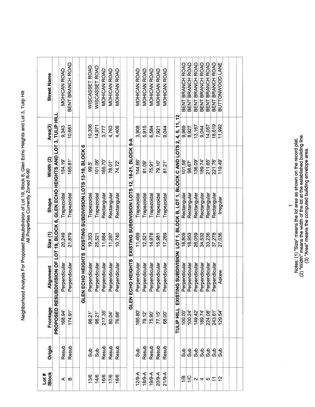
2 RECOMMENDATION: Approval subject to the following conditions: 1) Approval under this preliminary plan is limited to 2 lots for 2 dwelling units 2) The record plat must note that the preliminary plan is exempt from Forest Conservation Requirements per Exemption # E. 3) The applicant must comply with the conditions of the Montgomery County Department of Transportation (MCDO) letter dated November 8, These conditions may be amended by MCDOT, provided the amendments do not conflict with other conditions of the preliminary plan approval. 4) The record plat must show necessary easements. SITE DESCRIPTION The subject properties are identified as Lot 19, Block 6 and Lot 3 in the Glen Echo Heights and Tulip Hill subdivisions, respectively. Lot 19 consists of approximately 11,360 square feet. Lot 3, a corner lot, contains approximately 30,995 square feet. Both properties are zoned R-90. Lot 3 is located at the southeast corner of the intersection of Bent Branch and Mohican Road approximately 450 feet south of its intersection with Massachusetts Avenue. Lot 19 is located on the south side of Mohican Road approximately 200 feet from its intersection with Bent Branch Road. Lot 19 abuts the eastern property line of Lot 3. Both lots are developed with one family detached dwelling units. Access to Lot 19 is from Mohican Road while access to Lot 3 is from Bent Branch Road. Both roadways are 50 foot public rightsof-ways. The surrounding properties are also zoned R-90 and developed with one family detached dwelling units. See Vicinity and Development Map below. The properties are in the Minnehaha Branch watershed, a state designated Use 1- watershed. Both properties are developed with extensive vegetation, mature trees and moderate slopes. PROJECT DESCRIPTION The applicant owns both lots and is proposing to adjust the eastern lot line between Lot 19 and Lot 3. Under this application, Lot 19 will become Lot A and consist of approximately 20,249- square feet, while Lot 3 will become Lot B with approximately 21,879 square feet. This application is a major lot line adjustment and does not qualify as a minor subdivision because the amount of square footage being resubdivided (8,889 square feet) is in excess of the 5,000 square foot limit permitted under the minor lot line adjustment provisions of Chapter 50-35(a) (1) of the Montgomery County Code, Subdivision Regulations. Both lots are developed with a one-family detached dwelling unit. Access points to each lot will remain unchanged under this application. No new construction proposed by the subject application. The applicant has dedicated approximately 227 square feet of right of way at the intersection of Mohican and Bent Branch Roads. The proposed development plan is included as Attachment B. 2

3 Vicinity and Development Map ANALYSIS AND FINDINGS Conformance to the Master Plan The property is located in the Bethesda Chevy Chase Master Plan which does not specifically address the subject property. The Sector Plan recommends retention of existing zoning throughout the Sector Plan area in the absence of a specific recommendation for change on a particular property. In the case of the subject property, the Sector Plan calls for retention of the existing R-90 zoning. The proposed subdivision complies with the recommendations adopted in the Sector Plan in that it proposes one-family residential development consistent with surrounding development patterns and the current zoning designation. The proposed residential lots will be similar to surrounding lots with respect to dimensions, orientation, and shape. The proposed subdivision will not alter the existing pattern of development or land use and is in substantial conformance with the Sector Plan recommendation to 3
4 maintain the existing land use. Finally, two historic resources, Kimmel House and Glen Echo Historic District, were identified within 2,000 feet or less of the proposed subdivision. The subject application will have no direct impact on the identified historic resources. Public Facilities Roads and Transportation Under the proposed preliminary plan, the two existing homes on the subject site will remain and no new development is proposed. Since this preliminary plan is not proposing any new density on the site, the application is exempt from Adequate Public Facilities (APF) review. The proposed resubdivision will not have an adverse effect on the transportation network in the immediate vicinity of the subject property MCDOT has reviewed the submitted preliminary plan. Access to Lots A and B lots will be provided by existing driveways via Mohican and Bent Branch Roads, respectively. Sidewalks do not exist on either Bent Branch or Mohican Roads but staff has determined that the roads can be safely used by pedestrians at this time. The applicant will be required to execute and record a Declaration of Covenants prior to approval of the record plat that will require him to provide sidewalks if it ever becomes necessary. Both lots are subdivided and developed with one-family houses. The low volumes of traffic on each roadway allow pedestrians to safely travel in the roadways. Proposed vehicle and pedestrian access for the site will be safe and adequate. Other Public Facilities and Services Public facilities and services are available and will be adequate to serve the proposed development. The property will be served by public water and sewer systems. The application has been reviewed by the Montgomery County Fire and Rescue Service who has determined that the subject property has appropriate access for fire and rescue vehicles. The property is located in the Whitman cluster, which is operating at over 105% of program capacity for its elementary and middle schools. Since both dwelling units exist under the subject preliminary plan, the property is not subject to the school facility payment. Other public facilities and services, such as police stations, firehouses and health services are available to serve the existing dwelling units. Electrical, gas, and telecommunications services are also available to serve the property. Environment The proposed subdivision is exempt from the forest conservation requirements since no forest clearing, tree cutting, or land disturbance activity is proposed. An exemption letter ( E) was issued on May 23, 2011 for the subject property and it remains valid for the submitted preliminary plan. The MCDPS Stormwater Management Section has reviewed the subject application and determined it is exempt from the County s stormwater management requirements as no new construction is proposed under this subdivision. Compliance with the Subdivision Regulations and Zoning Ordinance 4
5 This application has been reviewed for compliance with the Montgomery County Code, Chapter 50, the Subdivision Regulations. The application meets all applicable sections, including the requirements for resubdivision as discussed in the subsequent sections. The proposed lot sizes, width, shape and orientation are appropriate for the location of the subdivision. The lots were reviewed for compliance with the dimensional requirements for the R-90 zone as specified in the Zoning Ordinance. The lots as proposed will meet all the dimensional requirements for area, frontage, width, and setbacks in that zone. A summary of this review is included in attached Table 1. The application has been reviewed by other applicable county agencies, all of whom have recommended approval of the plan. Conformance with Section 50-29(b)(2) A. Statutory Review Criteria In order to approve an application for resubdivision, the Planning Board must find that each of the proposed lots complies with all seven of the resubdivision criteria, set forth in Section 50-29(b)(2) of the Subdivision Regulations, which states: Resubdivision. Lots on a plat for the Resubdivision of any lot, tract or other parcel of land that is part of an existing subdivision previously recorded in a plat book shall be of the same character as to street frontage, alignment, size, shape, width, area and suitability for residential use as other lots within the existing block, neighborhood or subdivision. B. Neighborhood Delineation In administering Section 50-29(b)(2) of the Subdivision Regulations, the Planning Board must determine the appropriate neighborhood for evaluating the application. In this instance, the Neighborhood selected by the applicant, and agreed to by staff, consists of 17 lots (See Attachment C). The neighborhood includes platted lots in the R-90 and in the vicinity of Bent Branch and Mohican Roads. The lots share several access points on Mohican Road, Bent Branch Road, Wiscasset Road, Bay Tree Lane, and Buttonwood Lane, Massachusetts Avenue. The designated neighborhood provides an adequate sample of lots and development pattern in the area. A tabular summary of the area based on the resubdivision criteria is included in Attachment D. C. Analysis Comparison of the Character of Proposed Lots to Existing In performing the analysis, the above-noted resubdivision criteria were applied to the delineated neighborhood. The proposed lots are of the same character with respect to the resubdivision criteria as other lots within the defined neighborhood. Therefore, the proposed resubdivision complies with the criteria of Section 50-29(b)(2). As set forth below, the attached tabular summary and graphical documentation support this conclusion: Frontage: The delineated neighborhood contains 17 lots, with lot frontages ranging from 68 feet to 243 feet. Frontage for nine lots ranges from 68 feet to 100 feet, six lots have frontage 5
6 between 100 feet and 200 feet. The remaining three lots have frontage in excess of 200 feet. The two lots proposed by this subdivision will have frontages of 168 feet and 174 feet. The proposed lot will be of the same character as existing lots in the neighborhood with respect to lot frontage. Alignment: Of the 17 lots in the neighborhood, ten lots are perpendicular, six are corner lots and one lot is angular. Proposed Lot A will be perpendicular and proposed Lot B will be a corner lot. The proposed lots are of the same character as existing lots with respect to the alignment criterion. Size: Lot sizes in this neighborhood of 17 lots ranges from 10,740 square feet to 37,278 square feet. Eleven lots fall within the 10,000 square feet to 20,000 square feet range. Three lots are between 25,000 and 30,000 square feet with the remaining three lots ranging from 30,000 to 37,278 square feet. Lot A will be 20,249 square feet and Lot B will be 22,106 square feet. As noted above the delineated neighborhood does not contain any lots within the 20,000 square feet to 25,000 square feet range. The proposed lots offer an opportunity to fill the gap of lots absent in this size range. The proposed lot size is in character with the size of existing lots in the neighborhood. Shape: The 17 lots in the neighborhood consist of the following shapes: nine lots are rectangular, seven lots are trapezoidal and one lot is irregular. Lot A will be irregular in shape while Lot B will be trapezoidal. The shapes of the proposed lots will be in character with shapes of the existing lots. Width: Lots in the neighborhood range from approximately 75 feet to 221 feet in width. One lot is 74 feet in width. Ten lots are between 75 feet and 125 feet in width, three lots range from 125 feet to 175 feet in width, and the remaining three lots in excess of 175 feet in width. Lot A will be 154 feet in width while Lot B will be 165 feet in width. The proposed lots will be in character with existing lots in the neighborhood with respect to width. Area: The lots in the delineated neighborhood range from 3,777 square feet to 18,619 square feet. Four lots have buildable areas less than 5,000 square feet. Seven lots have buildable areas between 5,000 square feet and 10,000 square feet with five lots ranging from 10,000 square feet to 15,000 square feet. The remaining one lot has a buildable area in excess of 15,000 square feet. Buildable areas for proposed lots A and B will be 9,343 square feet and 10,661 square feet, respectively. The proposed lots will be of the same character as other lots in the neighborhood with respect to buildable area. Suitability for Residential Use: The existing and the proposed lots are zoned residential. Currently, a one family detached house is contained on each property and the land suitable for residential use. Citizen Correspondence and Issues The applicant conducted a pre-submission meeting on June 2, 2011 with the adjoining property owners and surrounding homeowner s associations. Written notice of the public hearing was given by the applicant and staff. To date, no resident letters have been received. 6
7 CONCLUSION Section 50-29(b)(2) of the Subdivision Regulations specifies seven criteria with which resubdivided lots must comply. They are street frontage, alignment, size, shape, width, area and suitability for residential use within the existing block, neighborhood or subdivision. As set forth above, the two proposed lots are of the same character as the existing lots in the defined neighborhood with respect to each of the resubdivision criteria, and therefore, comply with Section 50-29(b)(2) of the Subdivision Regulations. The proposed lots meet all requirements established in the Subdivision Regulations and the Zoning Ordinance and substantially conform to the recommendations of the Bethesda Chevy Chase Master Plan. Access and public facilities will be adequate to serve the proposed lots, and the application has been reviewed by other applicable county agencies, all of whom have recommended approval of the plan. Therefore, approval of the application with the conditions specified above is recommended. Attachments Attachment A Proposed Development Plan Attachment B Resubdivision Neighborhood Map Attachment C Resubdivision Data Table Attachment D MCDOT memo dated 11/8/11 7
8 Table 1: Preliminary Plan Data Table and Checklist Plan Name: Greenway Property Plan Number: Zoning: R-90 # of Lots: 2 # of Outlots: NA Dev. Type: Preliminary Plan PLAN DATA Minimum Lot Area Zoning Ordinance Development Standard 9,000 sq. ft. Proposed for Approval by the Preliminary Plan 20,249 sq. ft. Verified Date KAR 11/18/11 minimum Lot Width 75 ft. 154 ft. minimum KAR 11/18/11 Lot Frontage 25 ft. 168 ft. minimum KAR 11/18/11 Setbacks Front 30 ft. Min. Must meet minimum KAR 11/18/11 Side 8 ft. Min./25 ft. total Must meet minimum KAR 11/18/11 Rear 25 ft. Min. Must meet minimum KAR 11/18/11 Height Max Resid l d.u. or Comm l s.f. per Zoning 35 ft. Max. May not exceed maximum KAR 11/18/11 KAR 11/18/11 MPDUs N/a KAR 11/18/11 TDRs N/a KAR 11/18/11 Site Plan Req d? No KAR 11/18/11 FINDINGS SUBDIVISION Lot frontage on Public Street Yes KAR 11/18/11 Road dedication and frontage improvements Yes Agency letter 11/8/11 Environmental Guidelines N/a Staff memo 10/17/11 Forest Conservation Exempt Staff memo 10/17/11 Master Plan Compliance Yes Staff memo 10/17/11 Other (i.e., parks, historic preservation) No Staff memo 10/17/11 ADEQUATE PUBLIC FACILITIES Stormwater Management Exempt Agency 10/17/11 comments Water and Sewer (WSSC) N/a Agency 10/17/11 comments 10-yr Water and Sewer Plan Compliance N/a Agency 10/17/11 comments Well and Septic N/a Agency 10/17/11 comments Local Area Traffic Review N/a Staff memo 11/2/11 Policy Area Mobility Review N/a Staff Memo 11/2/11 Transportation Management Agreement No Staff Memo 11/2/11 School Cluster in Moratorium? No KAR 11/18/11 School Facilities Payment No KAR 11/18/11 Fire and Rescue Yes Agency letter 11/1/11 8
9 Attachment A
10 Attachment B
11 Attachment C
12 Attachment D
MONTGOMERY COUNTY PLANNING DEPARTMENT THE MARYLAND-NATIONAL CAPITAL PARK AND PLANNING COMMISSION
 MONTGOMERY COUNTY PLANNING DEPARTMENT THE MARYLAND-NATIONAL CAPITAL PARK AND PLANNING COMMISSION MCPB Item No. 8 Date: 03-07-13 Sonoma, Preliminary Plan, 120130040 Melissa Williams, Senior Planner, Melissa.williams@montgomeryplanning.org,
MONTGOMERY COUNTY PLANNING DEPARTMENT THE MARYLAND-NATIONAL CAPITAL PARK AND PLANNING COMMISSION
 MONTGOMERY COUNTY PLANNING DEPARTMENT THE MARYLAND-NATIONAL CAPITAL PARK AND PLANNING COMMISSION MCPB Item No. Date: 12/4/14 Preliminary Plan No. 120140200, Northwood Knolls Description Patrick Butler,
MONTGOMERY COUNTY PLANNING DEPARTMENT THE MARYLAND-NATIONAL CAPITAL PARK AND PLANNING COMMISSION
 MONTGOMERY COUNTY PLANNING DEPARTMENT THE MARYLAND-NATIONAL CAPITAL PARK AND PLANNING COMMISSION MCPB Item No. 3 Date: 01-31-13 Preliminary Plan 120090300, Boyds Highlands Calvin Nelson, Jr. Planner Coordinator,
MONTGOMERY COUNTY PLANNING DEPARTMENT THE MARYLAND-NATIONAL CAPITAL PARK AND PLANNING COMMISSION
 MONTGOMERY COUNTY PLANNING DEPARTMENT THE MARYLAND-NATIONAL CAPITAL PARK AND PLANNING COMMISSION MCPB Item No.: Date: 06-21-12 The Plantations, Preliminary Plan -120090240 Benjamin Berbert, Senior Planner,
MONTGOMERY COUNTY PLANNING DEPARTMENT THE MARYLAND-NATIONAL CAPITAL PARK AND PLANNING COMMISSION
 MONTGOMERY COUNTY PLANNING DEPARTMENT THE MARYLAND-NATIONAL CAPITAL PARK AND PLANNING COMMISSION MCPB Item No.: Date: 07-28-16 Lake Normandy Estates: Pre-Preliminary Plan No. 720160020 Ryan Sigworth AICP,
MONTGOMERY COUNTY PLANNING BOARD
 MONTGOMERY COUNTY PLANNING BOARD T H E MARYLAND-NATIONAL CAPITAL PARK A N D P L A N N I N G C O M M I S S I O N MCPB NO. 10-144 Hearing Date: September 30, 2010 MONTGOMERY COUNTY PLANNING BOARD RESOLUTION
MONTGOMERY COUNTY PLANNING DEPARTMENT THE MARYLAND-NATIONAL CAPITAL PARK AND PLANNING COMMISSION
 MONTGOMERY COUNTY PLANNING DEPARTMENT THE MARYLAND-NATIONAL CAPITAL PARK AND PLANNING COMMISSION MCPB Item No. Date: 1-17-13 Preliminary Plan 120110180 - Parmjit & Saini Estates Katherine Holt, Senior
MONTGOMERY COUNTY PLANNING DEPARTMENT THE MARYLAND-NATIONAL CAPITAL PARK AND PLANNING COMMISSION
 MONTGOMERY COUNTY PLANNING DEPARTMENT THE MARYLAND-NATIONAL CAPITAL PARK AND PLANNING COMMISSION MCPB Item No. Date: 10-11-12 Subdivision Review Waiver SRW 2011001: Big Woods Road Richard Weaver, Acting
MONTGOMERY COUNTY PLANNING BOARD
 MONTGOMERY COUNTYPLANNING BOARD T H E MARYLAND-NATIONAL CAPITAL PARK A N D P L A N N I N G C O M M I S S I O N MCPB NO. 10-100 Preliminary Plan No. 120100210 Date of Hearing: July 1, 2010 MONTGOMERY COUNTY
DANAC Stiles Property. Preliminary Plan A
 DANAC Stiles Property Preliminary Plan 11996112A Vicinity Located in the LSC North District of the GSSC Master Plan. Adjacent Uses North: Single-family attached townhouses, R-60 zone; East: Office building,
Article Optional Method Requirements
 Article 59-6. Optional Method Requirements [DIV. 6.1. MPDU DEVELOPMENT IN RURAL RESIDENTIAL AND RESIDENTIAL ZONES Sec. 6.1.1. General Requirements... 6 2 Sec. 6.1.2. General Site and Building Type Mix...
ARTICLE OPTIONAL METHOD REGULATIONS
 ARTICLE 59-6. OPTIONAL METHOD REGULATIONS DIV. 6.1. MPDU DEVELOPMENT IN RURAL RESIDENTIAL AND RESIDENTIAL ZONES SEC. 6.1.1. GENERAL REQUIREMENTS... 6 2 SEC. 6.1.2. GENERAL SITE AND BUILDING T PE MIX...
Final Plats for Major Residential and Commercial Subdivisions Checklist
 Project Name: : This form is a checklist of Zoning Ordinance requirements for major residential and commercial subdivision plats to assist the applicant in their submittal. It is not intended to be a comprehensive
PLANNED DEVELOPMENT DISTRICT STANDARDS. Cadence Site
 PLANNED DEVELOPMENT DISTRICT STANDARDS Cadence Site A Planned Development District 1. Statement of General Facts, Conditions and Objectives Property Size: Approximately 57.51 Acres York County Tax Map
FINAL DRAFT 12/1/16, Rev. to 7/18/17
 FINAL DRAFT 12/1/16, Rev. to 7/18/17 (As Adopted 8/8/17 Effective 9/1/17) SHELTON PLANNING AND ZONING COMMISSION Proposed Amendments to Zoning Regulations I. Amend Section 23 PERMITTED USES by inserting
PLANNING COMMISSION REPORT REGULAR AGENDA
 PP-4-4-11 Item No. 9-1 PLANNING COMMISSION REPORT REGULAR AGENDA PC Staff Report 06/22/11 ITEM NO 9: PRELIMINARY PLAT; KASOLD WATER TOWER ADDITION; SE OF TAM O SHANTER & KASOLD DR (MKM) PP-4-4-11: Consider
MONTGOMERY COUNTY PLANNING DEPARTMENT THE MARYLAND-NATIONAL CAPITAL PARK AND PLANNING COMMISSION
 MONTGOMERY COUNTY PLANNING DEPARTMENT THE MARYLAND-NATIONAL CAPITAL PARK AND PLANNING COMMISSION MCPB Item No. 6 Date: 9-27-18 Seneca Farms, Preliminary Plan No. 120170240 Jonathan Casey, Senior Planner,
WESTMINSTER PARK PLACE SUBDIVISION
 WESTMINSTER PARK PLACE SUBDIVISION Engineering Comments: FINAL PLAT COMMENTS (should be addressed prior to submitting the FINAL PLAT for review and/or signature by the City Engineer): A. Provide all of
Town of Cary, North Carolina Rezoning Staff Report 14-REZ-20 Habitat for Humanity Evans Road Town Council Meeting October 16, 2014
 Town of Cary, North Carolina Rezoning Staff Report 14-REZ-20 Habitat for Humanity Evans Road Town Council Meeting October 16, 2014 REQUEST To amend the Town of Cary Official Zoning Map by rezoning 0.53
WESTMINSTER PARK SUBDIVISION
 WESTMINSTER PARK SUBDIVISION Engineering Comments: FINAL PLAT COMMENTS (should be addressed prior to submitting the FINAL PLAT for review and/or signature by the City Engineer): A. Provide all of the required
MONTGOMERY COUNTY PLANNING DEPARTMENT THE MARYLAND-NATIONAL CAPITAL PARK AND PLANNING COMMISSION
 MONTGOMERY COUNTY PLANNING DEPARTMENT THE MARYLAND-NATIONAL CAPITAL PARK AND PLANNING COMMISSION MCPB Item No. 3 Date: 05/28/15 Ingleside, Preliminary Plan No. 120140140 Ryan Sigworth AICP, Senior Planner
Initial Subdivision Applications Shall Include the Following:
 Initial Subdivision Applications Shall Include the Following: 1) Subdivision Application Form: completely filled out (12 copies) 2) Plat: The Plat must adhere to the requirements set forth in the Town
DEPARTMENT OF PLANNING JEFFERSON PARISH, LOUISIANA
 DEPARTMENT OF PLANNING JEFFERSON PARISH, LOUISIANA SUBDIVISION REPORT DOCKET NO: ES-89-15-PF SUMMARY NO: COUNCIL DISTRICT 2 Paul D. Johnston COUNCIL AT LARGE: A Chris Roberts B Elton M. Lagasse ADVERTISING
MONTGOMERY COUNTY PLANNING DEPARTMENT THE MARYLAND-NATIONAL CAPITAL PARK AND PLANNING COMMISSION
 MONTGOMERY COUNTY PLANNING DEPARTMENT THE MARYLAND-NATIONAL CAPITAL PARK AND PLANNING COMMISSION Wheaton Woods, Preliminary Plan No. 120160060 MCPB Item No. Date: 02-25-16 Lori Shirley, Planner Coordinator,
A. Location. A MRD District may be permitted throughout the County provided it meets the standards established herein.
 752. Multi-Residential District (MRD) The Multi-Residential (MRD) District is intended to provide opportunities for rural, suburban and urban density mixed-residential developments consistent with the
JUSTIFICATION STATEMENT FOR PRELIMINARY PLAN NO Preliminary Plan Justification for Chevy Chase Lake
 I. INTRODUCTION JUSTIFICATION STATEMENT FOR PRELIMINARY PLAN NO. 120150130 Preliminary Plan Justification for Chevy Chase Lake Applicant, CC Associates LLC (the Applicant ), by its attorneys, Linowes and
BEFORE THE HEARINGS EXAMINER FOR THE CITY OF BREMERTON
 BEFORE THE HEARINGS EXAMINER FOR THE CITY OF BREMERTON In the Matter of the Application of ) NO. PL03-0017 ) Rainier Vista Bill Bakker ) ) FINDINGS, CONCLUSIONS For Approval of a Preliminary Plat. ) AND
CREEKSIDE TOWNHOMES Chevy Chase, Maryland Site Plan No Preliminary Plan No
 +1 (301) 656 5901 info@nova-habitat.com CREEKSIDE TOWNHOMES Chevy Chase, Maryland Site Plan No. 820160050 Preliminary Plan No. 120160130 Application Statement of Justification October 28, 2015 Nova-Habitat,
4. facilitate the construction of streets, utilities and public services in a more economical and efficient manner;
 PVPC MODEL BYLAW BY-RIGHT CLUSTER ZONING BYLAW Prepared by Pioneer Valley Planning Commission Revised: October 2001 1.00 Development 1.01 Development Allowed By Right Development in accordance with this
ASPEN GLEN PUD. Eighth Amended PUD Guidelines
 ASPEN GLEN PUD Eighth Amended PUD Guidelines A. Applicability Statement To carry out the purposes and provisions of the Garfield County Zoning Regulations, as amended, The Aspen Glen Club Planned Unit
DEPARTMENT OF PLANNING JEFFERSON PARISH, LOUISIANA
 DEPARTMENT OF PLANNING JEFFERSON PARISH, LOUISIANA SUBDIVISION REPORT DOCKET NO: ES-1-17-PF SUMMARY NO.: COUNCIL DISTRICT: 2 Paul D. Johnston COUNCIL AT LARGE: A: Christopher L. Roberts B: Cynthia Lee-Sheng
1. APPLICANT: Polsinelli, Shalton & Welte is the applicant for this request.
 5. REVISED PRELIMINARY PLAN APPROVAL - THE RETREAT AT MAPLECREST - Vicinity of the northeast corner of 159 th Street and U.S. 69 Highway 1. APPLICANT: Polsinelli, Shalton & Welte is the applicant for this
R e z o n i n g A p p l i c a t i o n S u b m i s s i o n R e q u i r e m e n t s
 H O R R Y C O U N T Y P L A N N I N G & Z O N I N G 1 3 0 1 2 N D A V E., S U I T E 1 D - 0 9 C O N W A Y, S. C. 2 9 5 2 6 P H O N E : 8 4 3. 9 1 5. 5 3 4 0 F A X : 8 4 3. 9 1 5. 6 3 4 1 R e z o n i n
BAY FOREST PARK SUBDIVISION, RESUBDIVISION OF LOTS 6 & 7 AND BAY FOREST PARK SUBDIVISION LOT 10, OF THE RESUBDIVISON OF LOTS 9 & 10
 BAY FOREST PARK SUBDIVISION, RESUBDIVISION OF LOTS 6 & 7 AND BAY FOREST PARK SUBDIVISION LOT 10, OF THE RESUBDIVISON OF LOTS 9 & 10 Engineering Comments: Must comply with the Mobile County Flood Damage
ARTICLE IV: DEVELOPMENT STANDARDS
 ARTICLE IV: DEVELOPMENT STANDARDS IV-53 409 PRIVATE STREETS A private street means any way that provides ingress to, or egress from, property by means of vehicles or other means, or that provides travel
Amendment to the Zoning and Subdivision Ordinances; Consider Repeal Cluster Development Standards
 2 Board of Supervisors Meg Bohmke, Chairman Gary F. Snellings, Vice Chairman Jack R. Cavalier Thomas C. Coen L. Mark Dudenhefer Wendy E. Maurer Cindy C. Shelton February 28, 2018 Thomas C. Foley County
MONTGOMERY COUNTY PLANNING BOARD
 APR :7 20m MONTGOMERY COUNTY PLANNING BOARD THE MARYLAND-NATIONAL CAPITAL PARK AND PLANNING COMMISSION MCPB No. 10-172 Date of Hearing: December 9, 2010 MONTGOMERY COUNTY PLANNING BOARD RESOLUTION WHEREAS,
(if more than one, give square footage for each) ANNEXATION LOT LINE Adjustments PRE/FINAL PLAT SPECIAL USE PERMIT
 ANNEXATION LOT LINE Adjustments PRE/FINAL PLAT SPECIAL USE PERMIT") Planning Commission Application Building & development office 915 Third ST. Rawlins WY ph. 307-328-4599 fax. 307-328-4590 PROJECT REVIEW: GENERAL INFORMATION Project name: OFFICE USE ONLY Site address
Planning Commission Application Building & development office 915 Third ST. Rawlins WY ph. 307-328-4599 fax. 307-328-4590 PROJECT REVIEW: GENERAL INFORMATION Project name: OFFICE USE ONLY Site address
Town of Cary, North Carolina Rezoning Staff Report 12-REZ-27 Morris Branch Town Council Public Hearing January 24, 2013
 Town of Cary, North Carolina Rezoning Staff Report 12-REZ-27 Morris Branch Town Council Public Hearing January 24, 2013 REQUEST To amend the Town of Cary Official Zoning Map to rezone approximately 9.0
NEWTON COUNTY BOARD OF COMMISSIONERS REQUEST FOR REZONING
 NEWTON COUNTY BOARD OF COMMISSIONERS REQUEST FOR REZONING CASE NUMBER PROPOSED LAND USE MAP EXISTING LAND USE MAP PROPOSED ZONING EXISTING ZONING WATERSHED LOCATION OWNER PETITIONER REPRESENTATIVE N/A
Section SKETCH PLAN REVIEW
 Section 210 - SKETCH PLAN REVIEW 1. Within 30 days of receiving a complete application for a subdivision involving three or more lots, the Zoning Administrator shall refer the matter to the first available
Single Family Residential
 Housing Development Tools Single Family Residential Single Family Residence 1 Current Accessory Apartment Ordinance Single Family Residence 600 Square Foot Accessory Apartment (Net Floor Area) Twice Minimum
Article 04 Single Family Residential Districts
 Article 04 Article 04 Section 04.01 Intent (a) R1A Residence District. The R1A Single Family Residential District is established to include areas of low density single-family residences and limited agricultural
MONTGOMERY COUNTY PLANNING DEPARTMENT THE MARYLAND-NATIONAL CAPITAL PARK AND PLANNING COMMISSION
 MONTGOMERY COUNTY PLANNING DEPARTMENT THE MARYLAND-NATIONAL CAPITAL PARK AND PLANNING COMMISSION MCPB Item No. Date: 05-30-13 Pre-Preliminary Plan No. 720130040: Potomac Highlands Callum Murray, supervisor,
REGULAR FINAL PLAT SUBDIVISION APPLICATION
 REGULAR FINAL PLAT SUBDIVISION APPLICATION Name of Subdivision (Subdivision Name must be approved by at 856-6216) ( )Cluster Subdivision ( )Lot-by-Lot Subdivision ( )Open Space Subdivision Name of Subdivision
STONE HEDGE SUBDIVISION, UNIT 1, RESUBDIVISION OF LOT 40 & WEST COMMON AREA
 # 5 SUB-000498-2018 STONE HEDGE SUBDIVISION, UNIT 1, RESUBDIVISION OF LOT 40 & WEST COMMON AREA Engineering Comments: Must comply with the Mobile County Flood Damage Prevention Ordinance. Development shall
Major Subdivision Application Packet. Revised June 2018
 Major Subdivision Application Packet Revised June 2018 Caroline County Department of Planning and Community Development 233 West Broaddus Avenue Bowling Green, VA 22427 www.co.caroline.va.us Phone: 804-633-4303
Town of Cary, North Carolina Rezoning Staff Report 13-REZ-13 An Zou Property Town Council Meeting November 21, 2013
 Town of Cary, North Carolina Rezoning Staff Report 13-REZ-13 An Zou Property Town Council Meeting November 21, 2013 REQUEST To amend the Town of Cary Official Zoning Map by rezoning 0.63 acres located
APPLICATION FOR LOT SPLIT
 APPLICATION FOR LOT SPLIT ELIGIBILITY Section 12.09.01 of the Land Development Code provides for review and approval of lot split, which shall include any of the following: 1. The division of a single
Application for Preliminary Plat Checklist
 Application for Preliminary Plat Checklist Note: No portion of an existing parcel may be sold or transferred to another party without first legally subdividing the property according to the City of Richmond
BEFORE THE HEARING EXAMINER FOR THURSTON COUNTY
 COUNTY COMMISSIONERS Cathy Wolfe District One Diane Oberquell District Two Robert N. Macleod District Three HEARING EXAMINER BEFORE THE HEARING EXAMINER FOR THURSTON COUNTY In the Matter of the Application
CERTIFICATION OF THE APPROVAL OF WATER AND SEWERAGE SYSTEMS
 ARTICLE 9 FORMS AND CHECK LISTS 9.100 On preliminary layout & final subdivision plat CERTIFICATION OF THE APPROVAL OF WATER AND SEWERAGE SYSTEMS I hereby certify that the (...type: private or pubic...)
APPLICATION FOR SUBDIVISION APPROVAL OF A SKETCH PLAN with checklist
 Prior to filing any application for SUBDIVISION approval, the applicant shall request in writing that the zoning administrator schedule a pre-submission conference. APPLICATION TO THE PLANNING BOARD TOWN
CITY OF OAK HARBOR Development Services Department
 CITY OF OAK HARBOR Development Services Department Shortt Subdiiviisiions Shorrtt Pllatt Reviiew Prrocess IIII What is a Short Plat, and when is it necessary? A short plat is a map that represents a short
CHAPTER 50 MONTGOMERY COUNTY SUBDIVISION REGULATIONS PLANNING BOARD DRAFT July 31, 2015
 CHAPTER 50 MONTGOMERY COUNTY SUBDIVISION REGULATIONS PLANNING BOARD DRAFT July 31, 2015 Chapter 50: Subdivision Regulations Page Intentionally Blank Chapter 50: Subdivision Regulations TABLE OF CONTENTS
TULSA PARK ESTATES SUBDIVISION, RESUBDIVISION OF LOT 6
 TULSA PARK ESTATES SUBDIVISION, RESUBDIVISION OF LOT 6 Engineering Comments: FINAL PLAT COMMENTS (should be addressed prior to submitting the FINAL PLAT for review and/or signature by the City Engineer):
Residential Major Subdivision Review Checklist
 Residential Major Subdivision Review Checklist Plan Submittal Requirements: 2 full sets of stamped plans Electric submittal - all plans contained in a single PDF 3 full sets if commercial kitchen or dining
PLANNING COMMISSION REPORT Regular Agenda -Public Hearing Item
 PDP-13-00518 Item No. 3B- 1 PLANNING COMMISSION REPORT Regular Agenda -Public Hearing Item PC Staff Report 2/24/14 ITEM NO. 3B PRELIMINARY DEVELOPMENT PLAN FOR HERE @ KANSAS; 1101 INDIANA ST (SLD) PDP-13-00518:
DEVELOPMENT DEPARTMENT STAFF REPORT STAFF REPORT DRESDEN DRIVE TOWNHOMES DCI
 DEVELOPMENT DEPARTMENT STAFF REPORT Meeting Date: September 13, 2018 Item #: PZ2018-319 STAFF REPORT DRESDEN DRIVE TOWNHOMES DCI Request: Project Name: Development of Community Compact (DCI) and six concurrent
FREQUENTLY USED PLANNING & ZONING TERMS
 City Of Mustang FREQUENTLY USED PLANNING & ZONING TERMS Abut: Having property lines, street lines, or zoning district lines in common. Accessory Structure: A structure of secondary importance or function
CHAPTER 50 MONTGOMERY COUNTY SUBDIVISION REGULATIONS
 CHAPTER 50 MONTGOMERY COUNTY SUBDIVISION REGULATIONS Effective February 13, 2017 Sec. 3. Effective Date. This amendment takes effect on February 13, 2017. The amendment applies to any Planning Board action
E L M E R B O R O U G H L A N D U S E B O A R D APPLICATION COVER SHEET (to be completed for all applications and appeals)
") E L M E R B O R O U G H L A N D U S E B O A R D APPLICATION COVER SHEET (to be completed for all applications and appeals) 1. Name(s): 2. Address: 3. Telephone Number(s): 4. E-mail: 5. Owner Name(s) (if
E L M E R B O R O U G H L A N D U S E B O A R D APPLICATION COVER SHEET (to be completed for all applications and appeals) 1. Name(s): 2. Address: 3. Telephone Number(s): 4. E-mail: 5. Owner Name(s) (if
THE COUNTY BOARD OF SUPERVISORS OF THE COUNTY OF DOUGLAS DOES ORDAIN AS FOLLOWS:
 8.1 SUBDIVISION CONTROL ORDINANCE THE COUNTY BOARD OF SUPERVISORS OF THE COUNTY OF DOUGLAS DOES ORDAIN AS FOLLOWS: SECTION I. GENERAL INTERPRETATION This ordinance shall not repeal, impair or modify private
PLANNED UNIT DEVELOPMENT & SUBDIVISION STAFF REPORT Date: July 20, 2017
 PLANNED UNIT DEVELOPMENT & SUBDIVISION STAFF REPORT Date: July 20, 2017 DEVELOPMENT NAME SUBDIVISION NAME LOCATION Rangeline Crossing III Subdivision Rangeline Crossing III Subdivision 5289 Halls Mill
The Maryland-National Capital Park and Planning Commission Prince George s County Planning Department Development Review Division
 The Maryland-National Capital Park and Planning Commission Prince George s County Planning Department Development Review Division 301-952-3530 Note: Staff reports can be accessed at www.mncppc.org/pgco/planning/plan.htm.
610 LAND DIVISIONS AND PROPERTY LINE ADJUSTMENTS OUTSIDE A UGB
 ARTICLE VI: LAND DIVISIONS AND PROPERTY LINE ADJUSTMENTS VI-21 610 LAND DIVISIONS AND PROPERTY LINE ADJUSTMENTS OUTSIDE A UGB 610-1 Property Line Adjustments (Property Line Relocation) A property line
Draft Zoning Changes for the 2nd Planning Board Public Hearing, January 22, 2018.
 Draft Zoning Changes for the 2nd Planning Board Public Hearing, January 22, 2018. No changes were made at the 1st Public Hearing. Proposed wording for the 1 st Public Hearing in red, eliminated text in
ARTICLE 5 MINOR SUBDIVISION/LAND DEVELOPMENT
 ARTICLE 5 MINOR SUBDIVISION/LAND DEVELOPMENT SECTION 501 ONLY FINAL PLAN REQUIRED The classification of a proposed subdivision as a "Minor Subdivision" shall only require the submission, review and approval
ARTICLE 3 DEFINITIONS
 Sections: 3-1 Rules of Construction 3-2 Definitions ARTICLE 3 DEFINITIONS SECTION 3-1 RULES OF CONSTRUCTION 3-101. a. The language set forth in these regulations shall be interpreted in accordance with
PRELIMINARY PLAT CHECK LIST
 PRELIMINARY PLAT CHECK LIST Name of Proposed Subdivision: The following items must be included with the initial submittal of a Preliminary Plat: Application, filled out completely Project Narrative Pre-application
BOSSIER CITY PARISH METROPOLITAN PLANNING COMMISSION 620 Benton Rd. Bossier City, LA Phone: Fax: PRELIMINARY PLAT
 (OFFICE USE ONLY) Application Fee: Paid: Date: CASE # Project Information BOSSIER CITY PARISH METROPOLITAN PLANNING COMMISSION 620 Benton Rd. Bossier City, LA 71111 Phone: 318-741-8824 Fax: 318-741-8827
ORDINANCE NUMBERb5"- 03
 ORDINANCE NUMBERb5"- 03 AMENDMENTS TO THE MASON COUNTY DEVELOPMENT REGULATIONS AND TITLE 16 (PLATS AND SUBDIVISIONS) REGARDING BOUNDARY LINE ADJUSTMENTS. AN ORDINANCE amending the Mason County Development
WHEREAS, the staff of The Maryland-National Capital Park and Planning Commission recommended APPROVAL of the application with conditions; and
 R E S O L U T I O N WHEREAS, Redeemed Christian Church of God is the owner of a 2.83-acre parcel of land known as Lot 9, Lot 19, P/O Lot 1 and P/O Lot 18, Block B, Plat Book A, Plat 5, said property being
SECTION 10.7 R-PUD (RESIDENTIAL PLANNED UNIT DEVELOPMENT) ZONE
 ZONE") Article X Zones 10-20 SECTION 10.7 R-PUD (RESIDENTIAL PLANNED UNIT DEVELOPMENT) ZONE A. PURPOSE AND INTENT: The R-PUD Residential PUD Zone is intended to provide alternative, voluntary zoning procedures
Article X Zones 10-20 SECTION 10.7 R-PUD (RESIDENTIAL PLANNED UNIT DEVELOPMENT) ZONE A. PURPOSE AND INTENT: The R-PUD Residential PUD Zone is intended to provide alternative, voluntary zoning procedures
ARTICLE FIVE FINAL DRAFT
 ARTICLE FIVE 021218 FINAL DRAFT Sec. 503.6 Open Space Preservation Option Open Space Preservation Option Open Space Preservation developments may be approved in the AR, R-1, R-2 and R-3 zoning districts,
TERRY POIROUX FAMILY DIVISION SUBDIVISION
 TERRY POIROUX FAMILY DIVISION SUBDIVISION Engineering Comments: Must comply with the Mobile County Flood Damage Prevention Ordinance. Development shall be designed to comply with the storm water detention
SUBJECT PARCEL(S) Property Owner(s) TMS Number Approximate Acreage Carolina Park Development, LLC
 Property Owner(s) TMS Number Approximate Acreage Carolina Park Development, LLC") Staff Report Special Planning Commission Meeting November 19, 2014 For reference, the Zoning Code and Land Development Regulations are available online. AGENDA ITEM 5c. SKETCH PLAN APPROVAL REQUEST: Request
Staff Report Special Planning Commission Meeting November 19, 2014 For reference, the Zoning Code and Land Development Regulations are available online. AGENDA ITEM 5c. SKETCH PLAN APPROVAL REQUEST: Request
Courtyards at Kinnamon Park Sketch Plan
 Courtyards at Kinnamon Park Sketch Plan Courtyards at Kinnamon Park Sketch Plan Staff Analysis PART 1: PROJECT SUMMARY Applicant: EPCON Communities Property Owner: Johnsie M. Kinnamon Heirs, Douglas and
Sterling Meadow Subdivision
 Sterling Meadow Subdivision Proposal: A pre-application conference was held on November 7, 2017, with the applicant and City staff to discuss the development. The applicant took staff s recommendations
Town of Shelburne, Vermont
 Town of Shelburne, Vermont CHARTERED 1763 P.O. BOX 88 5420 SHELBURNE ROAD SHELBURNE, VT 05482 www.shelburnevt.org 802-985-5118 * * Also available in alternate formats in accordance with the Americans With
AN ORDINANCE AMENDING THE CODE OF ORDINANCES OF THE TOWN OF TRYON. Chapter 156 Subdivision Ordinance
 AN ORDINANCE AMENDING THE CODE OF ORDINANCES OF THE TOWN OF TRYON Chapter 156 Subdivision Ordinance Chapter 156: Subdivision Regulations ARTICLE I GENERAL PROVISIONS Section 1.1 Title This Ordinance shall
the conditions contained in their respective Orders until January 1, 2025, at the discretion of the Director of Planning, Property and Development.
 Part 4: Use Regulations Temporary Uses and Structures Purpose the conditions contained in their respective Orders until January 1, 2025, at the discretion of the Director of Planning, Property and Development.
Special Use Permit - Planned Unit Development Checklist. Property Address:
 Special Use Permit - Planned Unit Development Checklist Special Use Permit Number. Parcel Code/s #28-11- - - Property Address: Applicant: ARTICLE VIII Ordinance Reference - Section 8.1.2 Permit Procedures:
MONTGOMERY COUNTY CODE Chapter 50. Chapter 50. SUBDIVISION OF LAND.
 MONTGOMERY COUNTY CODE Chapter 50 Chapter 50. SUBDIVISION OF LAND. Article I. In General. Division 50.1. Purpose Section 50.1.1. Purpose of Chapter 1 Division 50.2. Defined Terms Section 50.2.1. Rules
Address Southeast Quadrant of U.S. Highway 41 and Sumter Boulevard City. North Port State. FL Zip Code County
 SUBJECT AERIAL LOCATION LAND AREA THREE-YEAR OWNERSHIP HISTORY OF SUBJECT Address Southeast Quadrant of U.S. Highway 41 and Sumter Boulevard City North Port State FL Zip Code 34287 County Sarasota Nearest
Residential Minor Subdivision Review Checklist
 Residential Minor Subdivision Review Checklist Plan Submittal Requirements: 2 full sets of stamped plans Electric submittal - all plans contained in a single PDF 3 full sets if commercial kitchen or dining
TABLE (A): TABLE OF DIMENSIONAL STANDARDS IN THE RESIDENTIAL ZONE DISTRICTS REQUIRED YARDS [4], [5] SIDE YARD (FT) REAR YARD (FT) R-1 DISTRICT
![TABLE (A): TABLE OF DIMENSIONAL STANDARDS IN THE RESIDENTIAL ZONE DISTRICTS REQUIRED YARDS [4], [5] SIDE YARD (FT) REAR YARD (FT) R-1 DISTRICT](/thumbs/85/92855381.jpg "TABLE (A): TABLE OF DIMENSIONAL STANDARDS IN THE RESIDENTIAL ZONE DISTRICTS REQUIRED YARDS [4], [5] SIDE YARD (FT) REAR YARD (FT) R-1 DISTRICT") ARTICLE : DENSITY, INTENSITY, & DIMENSIONAL STANDARDS Section -100: General Provisions TABLE 17--100(A): TABLE OF DIMENSIONAL STANDARDS IN THE RESIDENTIAL ZONE DISTRICTS R-1 DISTRICT AREA (SQ FT)[3] WIDTH
ARTICLE : DENSITY, INTENSITY, & DIMENSIONAL STANDARDS Section -100: General Provisions TABLE 17--100(A): TABLE OF DIMENSIONAL STANDARDS IN THE RESIDENTIAL ZONE DISTRICTS R-1 DISTRICT AREA (SQ FT)[3] WIDTH
STATE OF MICHIGAN COUNTY OF MARQUETTE, TOWNSHIP OF NEGAUNEE LAND DIVISION, SUBDIVISION AND CONDOMINIUM ORDINANCE
 STATE OF MICHIGAN COUNTY OF MARQUETTE, TOWNSHIP OF NEGAUNEE LAND DIVISION, SUBDIVISION AND CONDOMINIUM ORDINANCE Adopted: August 8 th, 2008 Effective: August 28 th, 2008 Sec.100. Title ARTICLE I GENERAL
PLANNED DEVELOPMENT: MASTER PLAN (Preliminary Subdivision Plat)
") TOWN OF CLAYTON Planning Department 111 E. Second Street, Clayton, NC 27520 P.O. Box 879, Clayton, NC 27528 Phone: 919-553-5002 Fax: 919-553-1720 PLANNED DEVELOPMENT: MASTER PLAN (Preliminary Subdivision
TOWN OF CLAYTON Planning Department 111 E. Second Street, Clayton, NC 27520 P.O. Box 879, Clayton, NC 27528 Phone: 919-553-5002 Fax: 919-553-1720 PLANNED DEVELOPMENT: MASTER PLAN (Preliminary Subdivision
APPLICATION PROCEDURE
 ANTRIM PLANNING BOARD P. O. Box 517 Antrim, New Hampshire 03440 Phone: 603-588-6785 FAX: 603-588-2969 APPLICATION FORM AND CHECKLIST FOR MINOR OR MAJOR SITE PLAN REVIEW File Date Received By APPLICATION
SUBDIVISION REGULATIONS
 CHAPTER 14 SUBDIVISION REGULATIONS 14-100 Provisions 14-200 Preliminary Plat 14-300 Final Plat 14-400 Replat 14-500 Minor Subdivision 14-600 Administrative Replat 14-700 Vacation of Roadways, Public Easements,
TOWN OF NORTHWOOD, NEW HAMPSHIRE
 TOWN OF NORTHWOOD, NEW HAMPSHIRE OFFICE OF THE PLANNING BOARD 818 First New Hampshire Turnpike, Northwood NH 03261 (603)942-5586 Extension 205 Facsimile: (603)942-9107 Major Subdivision Application Form
MINOR SUBDIVISION FINAL PLAT APPLICATION Town of Apex, North Carolina
 MINOR SUBDIVISION FINAL PLAT APPLICATION Town of Apex, North Carolina This document is a public record under the North Carolina Public Records Act and may be published on the Town s website or disclosed
City of Prior Lake APPLICATION FOR COMBINED PRELIMINARY AND FINAL PLAT
 Case File No. Property Identification No. City of Prior Lake APPLICATION FOR COMBINED PRELIMINARY AND FINAL PLAT Requested Action Brief description of proposed project (Please describe the proposed amendment,
Draft Model Access Management Overlay Ordinance
 Draft Model Access Management Overlay Ordinance This model was developed using the City of Hutchinson and the Trunk Highway 7 corridor. The basic provisions of this model may be adopted by any jurisdiction
TOWNSHIP OF DOYLESTOWN APPLICATION FOR REVIEW OF SUBDIVISION OR LAND DEVELOPMENT PROPOSAL. Please PRINT; all information MUST be filled out completely
 TOWNSHIP OF DOYLESTOWN APPLICATION FOR REVIEW OF SUBDIVISION OR LAND DEVELOPMENT PROPOSAL Please PRINT; all information MUST be filled out completely Date: Name of Subdivision or Land Development: Location:
Level III Preliminary and Final Site Plans Development Review Application Portland, Maine Planning and Urban Development Department Planning Division
 Level III Preliminary and Final Site Plans Development Review Application Portland, Maine Planning and Urban Development Department Planning Division Portland s Planning and Urban Development Department
MONTGOMERY COUNTY PLANNING DEPARTMENT THE MARYLAND-NATIONAL CAPITAL PARK AND PLANNING COMMISSION
 MONTGOMERY COUNTY PLANNING DEPARTMENT THE MARYLAND-NATIONAL CAPITAL PARK AND PLANNING COMMISSION MCPB Item No. 5 Date: 12-15-16 Bradford s Landing, Preliminary Plan, 120170060 Description Sandra Pereira,
PLANNING COMMISSION REPORT Regular Agenda Non Public Hearing Item
 PC Staff Report 3/23/15 FDP-14-00551 Item No. 2-1 PLANNING COMMISSION REPORT Regular Agenda Non Public Hearing Item PC Staff Report 3/23/15 ITEM NO. 2: FINAL DEVELOPMENT PLAN FOR HUTTON FARMS WEST PHASE
SUBDIVISION DESIGN PRINCIPLES AND STANDARDS
 SECTION 15-200 SUBDIVISION DESIGN PRINCIPLES AND STANDARDS 15-201 STREET DESIGN PRINCIPLES 15-201.01 Streets shall generally conform to the collector and major street plan adopted by the Planning Commission