MONTGOMERY COUNTY PLANNING DEPARTMENT THE MARYLAND-NATIONAL CAPITAL PARK AND PLANNING COMMISSION
|
|
|
- Gillian Young
- 5 years ago
- Views:
Transcription
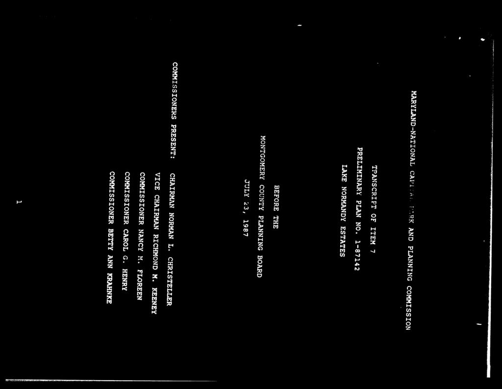
1 MONTGOMERY COUNTY PLANNING DEPARTMENT THE MARYLAND-NATIONAL CAPITAL PARK AND PLANNING COMMISSION MCPB Item No.: Date: Lake Normandy Estates: Pre-Preliminary Plan No Ryan Sigworth AICP, Senior Planner, (301) Rich Weaver, Supervisor, (301) Kip Reynolds, Area 3 Chief, Kipling.Reynolds@montgomeryplanning.org, (301) Description Lake Normandy Estates: Pre-Preliminary Plan No Request to receive non-binding advice from the Montgomery County Planning Board on the resubdivision of one platted lot into two (2) lots; located at 9108 Marseille Drive: 0.94 acres; R-200 zone; 2002 Potomac Subregion Master Plan. Applicant: Ali Zahedian Submittal Date: 1/14/2016 Review Basis: Chapter 50 Staff Report Date: 07/15/16 Summary Limited to non-binding advice from the Planning Board on resubdivision of this lot This report provides information to determine whether or not the proposed resubdivision neighborhood is appropriate; the size, shape and orientation is appropriate given its location in the neighborhood, and is keeping neighborhood character based on resubdivision criteria Forest conservation, Adequate Public Facilities, Stormwater and Fire and Rescue review will occur upon preliminary plan submittal
 (Figure 1).")
2 Site Description The property is a 0.94-acre platted lot, identified as Lot 5, Block G on Plat No (Attachment G), located at 9108 Marseille Drive, approximately 0.40 miles from the intersection of Falls Road and Marseille Drive ( Property or Subject Property ) (Figure 1). Figure 1 - Vicinity Map The Property is part of the Lake Normandy subdivision plat recorded in 1953 (Attachment H). Originally, the lots along Marseille Drive were developed on septic systems. In 1969, a public sewer line was installed along Marseille Drive. It is unknown if all homes along Marseille Drive have upgraded to public sewer or remain on septic systems. The Property is zoned R-200 in the 2002 Potomac Subregion Master Plan ( Master Plan ). The Property has one existing detached single family home built in 1957 (Figure 2) with a driveway accessing Marseille Drive. 2

3 Site Vicinity Surrounding the Property on all sides are detached single-family homes in the R-200 zone. The properties to the south were developed using the cluster provisions in the subdivision regulations in The properties to the north were developed in 1965 using the density control regulations which has since been retired. The Property is located in the Cabin John Creek Watershed (Use IP). There are no streams, forest or wetlands and the Property is in water categories W-1 and sewer category S-1. Figure 2 Aerial Map 3
4 Project Description The plan, designated as Pre-Preliminary Plan No , Lake Normandy Estates ( Pre-Preliminary Plan or Application ), requests non-binding advice on the potential to resubdivide one lot in order to create two (2) lots at 20,487 square feet and 20,470 square feet in the R-200 zone (Figure 3). Public water and sewer will serve both lots. The existing right-of-way dedicated with the original plat meets all requirements and no additional right-of-way is needed. Because of the existing residential structure is in the middle of the exact lot and in order to create two lots the existing residential structure would need to be razed because it would be bisected by the new property line. The existing structure would need to be removed prior to recordation of a new record plat. Figure 3 - Proposed Pre-Preliminary Plan 4
(2) which states: Resubdivision.")
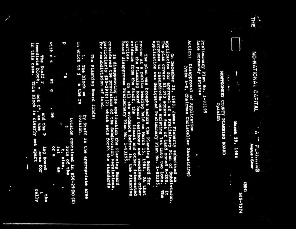
5 Figure 4 Resubdivision History Issues to Examine in this Pre-Preliminary Plan This Application requests the Planning Board to provide non-binding advice on two aspects of a resubdivision of one recorded lot into two lots. Resubdivisions are regulated by Section 50-29(b)(2) which states: Resubdivision. Lots on a plat for the Resubdivision of any lot, tract or other parcel of land that is part of an existing subdivision previously recorded in a plat book shall be of the same character as to street frontage, alignment, size, shape, width, area and suitability for residential use as other lots within the existing block, neighborhood or subdivision. There are two main issues to be examined with this Pre-Preliminary plan: 1) delineating the proposed Neighborhood, and 2) determining if the proposed lots are of the same character with existing lots by examining the seven resubdivision analysis criteria. 1. Resubdivision Neighborhood In administering Section 50-29(b)(2) of the Subdivision Regulations, the Planning Board must determine the appropriate Neighborhood for evaluating the application. 5
6 Applicant s Neighborhood The Applicant has submitted a Neighborhood for review by Staff and the Planning Board (Figure 5) (Attachment B & C). The Neighborhood has been determined by using the accepted practices of the Planning Board. Generally, lots that abut the Subject Property and that are visible to motorists who travel from the larger collector road(s) to the Subject Property are considered for inclusion in the Neighborhood. While properties in the vicinity are all in the R-200 zone, some properties to the north of the Neighborhood were developed using Density Control standards in Properties to the south were development using the cluster method. Because these two methods allowed lots to be platted which were smaller than the R-200 zone minimum lot size for standard method development (20,000 square foot minimum), these properties to the north and south were not included in the Neighborhood, which is consistent with previous Planning Board practice. Parts of lots were also excluded and any other property that was not properly recorded by record plat were also excluded as is the generally accepted Planning Board practice. This has resulted in a 36-lot Neighborhood which the Applicant and Staff agree is appropriate and suitable for a resubdivision analysis. Figure 5 Applicant s Proposed Neighborhood Staff s Position on the Neighborhood Staff accepts the Applicant s Neighborhood based on the Board s most current practice of including surrounding lots that are located within the same zone (R-200), that were built using the same 6
7 development standards, and are located in a way that the Subject Property has a direct impact to them either because of adjacency or frequent interaction including motorists who might pass by the Property from the next larger road classification. This corridor along Marseille Drive includes lots on both sides of the street whose owners would most frequently pass by and/or interact with the Subject Property and would, therefore, be most impacted by a change to the Property. Staff also believes the Neighborhood provides an adequate sampling of comparable lots developed under the same development standards. A tabular summary of the resubdivision criteria based on the Neighborhood is included in Attachment C. 2. Resubdivision Criteria Analysis Comparison of the Character of Proposed Lots to Existing It is Staff s opinion that the proposed lots are of the same character with respect to the resubdivision criteria as other lots within the defined neighborhood. Therefore, the proposed resubdivision complies with the criteria of Section 50-29(b)(2). As set forth below, the attached tabular summary and graphical documentation support this conclusion: Frontage: The proposed lot will be of the same character as existing lots in the neighborhood with respect to lot frontage. Both proposed lots have a frontage of 110 feet. In the Neighborhood, the range of non-corner lot frontages is between 25 and 348 feet. The proposed lots are at the low end of the range but within the range of lot frontages in the Neighborhood. Alignment: The proposed lots are of the same character as existing lots in the neighborhood with respect to the alignment criterion. The alignment of the proposed lots is perpendicular. Lots in the Neighborhood are a mix of perpendicular, angular, radial alignments. Specially, the proposed Neighborhood contains 17 perpendicular, 1 angular, and 18 radial alignments. Size: The proposed lot size of the same character with the size of existing lots in the Neighborhood. The lot size proposed by this Pre-Preliminary Plan is 20,487 and 20,470 square feet, respectively. The range of lot sizes in the Neighborhood is between 20,000 and 87,120 square feet. These proposed lots are only 487 and 470 square feet larger than the smallest lots in the Neighborhood (two lots are 20,000 square feet). Thus, the proposed lots are at the low end of the range but within the range of lot sizes in the Neighborhood. Shape: The shapes of the proposed lots will be in character with shapes of the existing lots in the neighborhood. Both proposed lots are rectangular (regular in the datasheets) in shape. Because of the meandering nature of Marseille Drive, the proposed Neighbor has a variety of lot shapes. The Neighborhood contains a mix of lot shapes including pipestem, rectangular, squares, triangular and irregular shapes. Width: The proposed lots are of similar character with existing lots in the neighborhood with respect to width. The lot width for both lot proposed by this Pre-Preliminary Plan is 112 feet, which is on 7
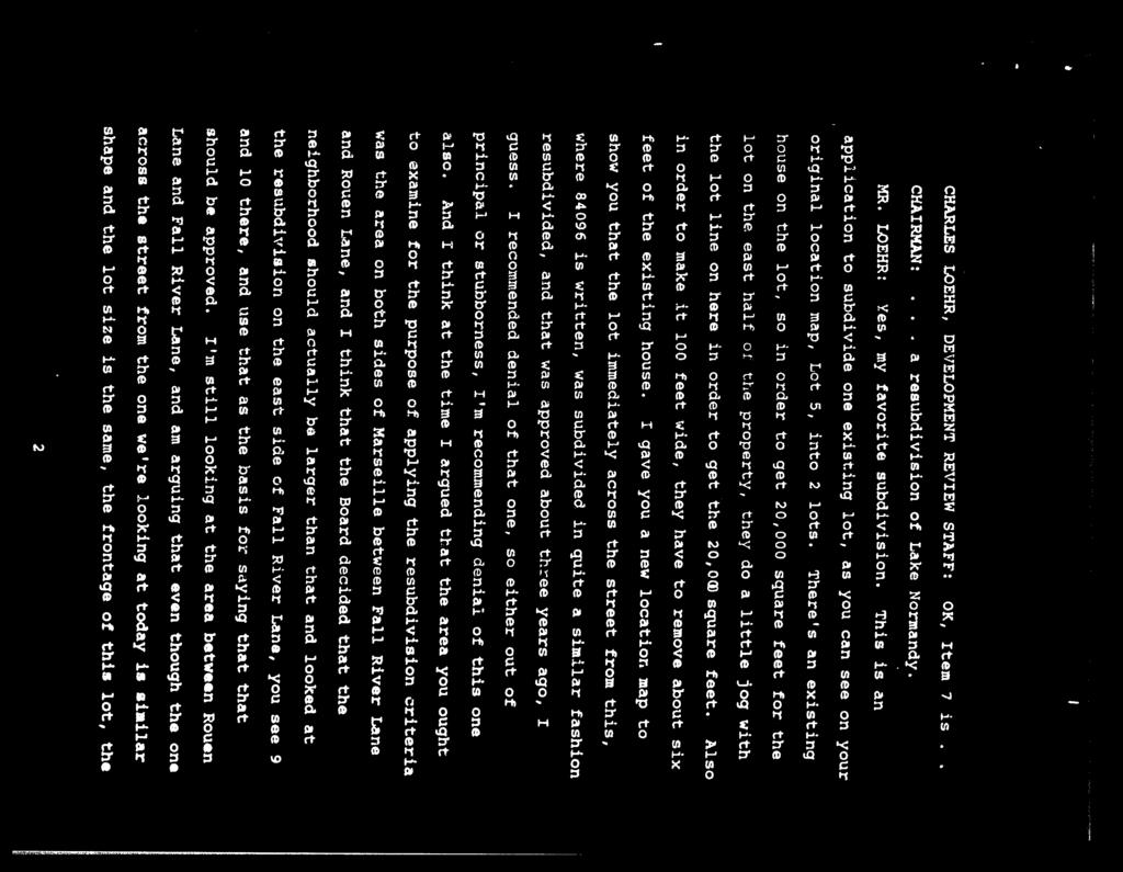
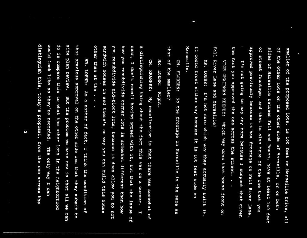
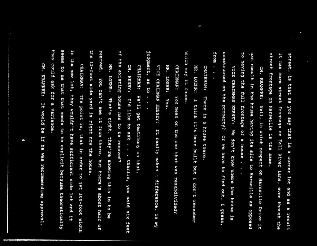
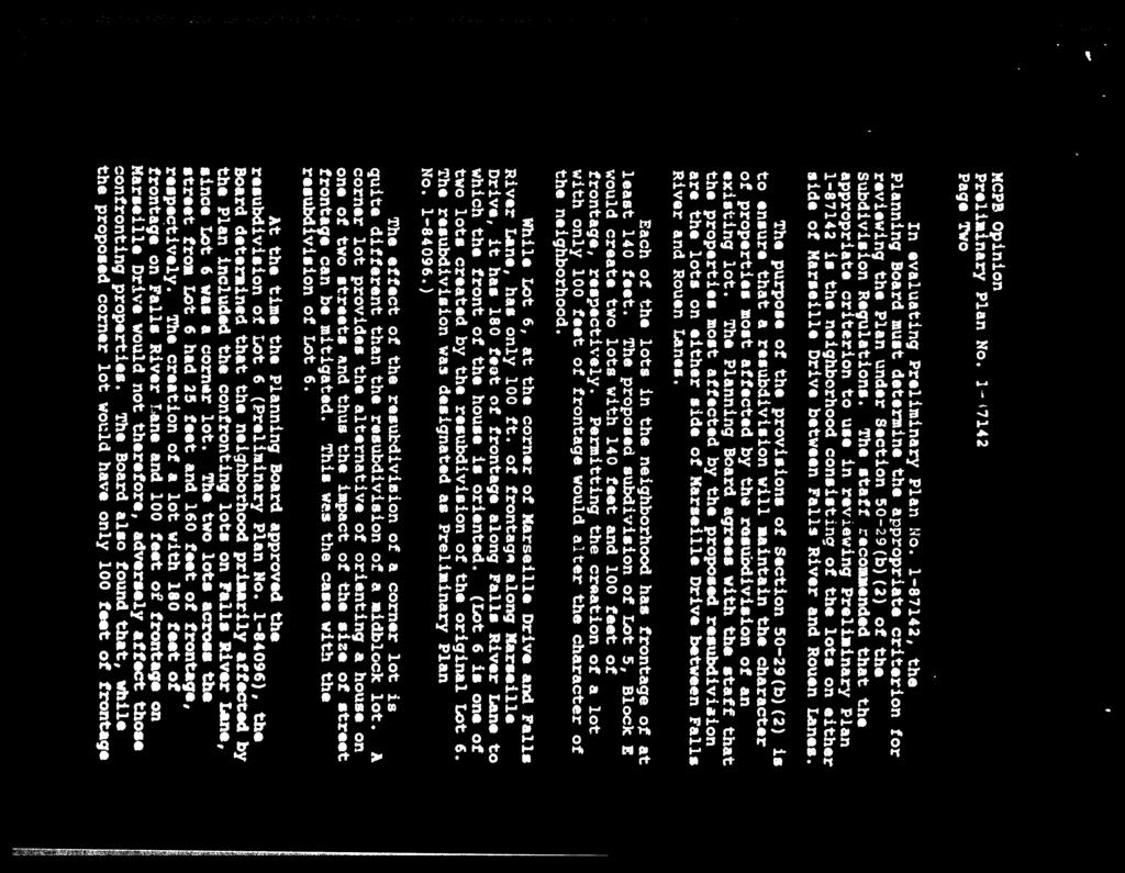
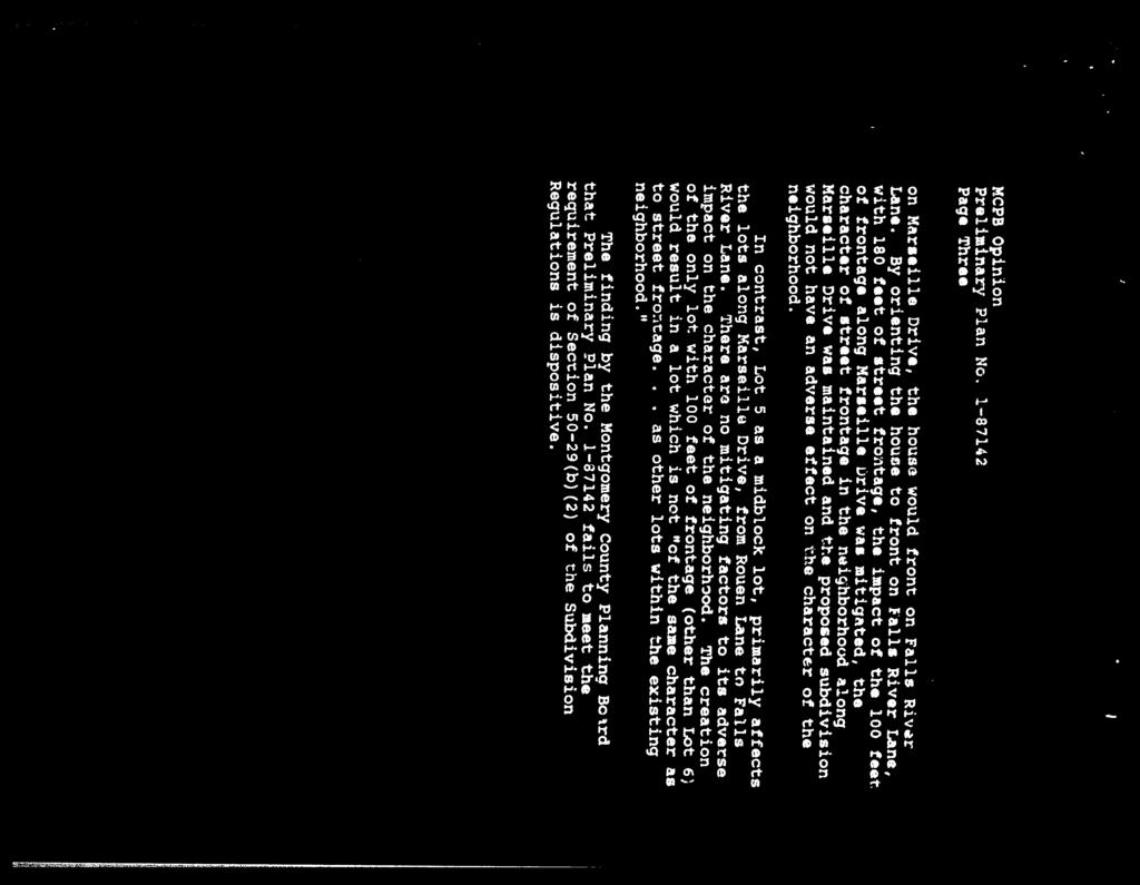
8 the low end of the range of lot width within the Neighborhood which is between 100 and 339 feet. Nonetheless, the lot width is within the range of existing lot widths. Area: The proposed lots will be of the same character as existing lots in the neighborhood with respect to buildable area. Both proposed lots offer a building area of 9,782 and 9,779 square feet respectively; within the range of buildable areas for lots in the proposed Neighborhood which range between 6,074 and 54,202 square feet. The proposed lots will be the 5 th and 6 th smallest in terms of buildable area. Suitability for Residential Use: The existing and the proposed lots are all zoned R-200 and the land is suitable for residential use. Citizen Correspondence and Issues This Application was submitted in accordance with all Planning Board adopted procedures for Pre- Preliminary Plans for non-binding advice. As of this writing, Staff has received numerous opposition letters from surrounding property owners. In addition, Staff also received four letters in support. (Attachment I) Conclusion The Planning Board is being asked to review the Neighborhood under Section 50-29(b)(2), and whether or not the proposed lots meet the resubdivision criteria established under Section 50-29(b)(2). Staff is of the opinion that the proposed Neighborhood is a representative sample of lots in the area established under the same development guidelines. The Application has demonstrated compliance to the resubdivision criteria in Section 50-29(b)(2) of the Subdivision Regulation. Both proposed lots fall within the numerical range for all of the resubdivision criteria based on the lot data of the proposed Neighborhood and are therefore, of the same character as existing lots in the Neighborhood. Attachments Attachment A Proposed Pre-Preliminary Plan Attachment B Proposed Neighborhood Delineation Attachment C Tabular Neighborhood Data by Criteria Attachment D Planning Board Opinion on Preliminary Plan No (August 26, 1987) Attachment E Planning Board Transcript for Preliminary Plan No (July 23, 1987) Attachment F Planning Board Opinion on Preliminary Plan No (March 29, 1984) Attachment G Plat No Attachment H Preliminary Plan No Attachment I Citizen Correspondence 8
9 Attachment A ZONING STANDARDS: ZONE: R-200 Req. Prov. Sheet 1 of 1 Revisions E Lot Size 20,000 sf 20,000 sf + Front Setback 40' 40' or more 375 Lot 4 Jean-Paul Lavalleye 9119 Marseille Dr. L F.79 Ex. E.O.P. Sideyards 12' min., 25' total 12' or more Rearyard 30' 30' or more Building Height 50' Max. 50' or less Lot Coverage* 20% Max. 20% or Less Lot 6 Andrew Greenwald Fall River Ct. 12' BRL 1 20,487 sf 30' BRL 30' BRL Proposed New Lot Line 40' BRL 13' BRL # 9108 Ex. House 13' BRL 40' BRL 12' BRL 60' (Ex.) Lot 7 Ralph Heilman 9102 Marseille Dr. Ex. E.O.P. Lot 5 Daofeng He 9101 Marseille Dr. Lot Building Line 100' 100' or more Frontage 25' 109' or more * Maximums shown are for infill development. NOTES: 1. AREA OF PROPERTY ACRES (40,957 SF) 3. EXISTING ZONING: R NUMBER OF LOTS PERMITTED NUMBER OF LOTS SHOWN SITE TO BE SERVED BY PUBLIC WATER AND SEWER. 7. EXISTING SEWER & WATER SERVICE CATEGORIES: S-1, W-1 8. LOCATED IN CABIN JOHN CREEK WATERSHED. 9. PROPERTY LOCATED ON TAX MAP FQ61; WSSC SHEET 214NW UTILITIES PROVIDED BY: Washington Gas, Verizon, PEPCO LEGEND: 1/13/16 date: Benning & Associates, Inc. Land Planning Consultants 8933 Shady Grove Court Gaithersburg, MD (301) " = 30' scale: Lot 5 Richard Rothman Fall River Ct. Proposed House Ex. Building G Ex. Topographic Contour Ex. Boundary Line FALL RIVER COURT 6 Lot 4 Leonard Sacks Fall River Ct. FALL RIVER LANE Building Restriction Line VICINITY MAP SCALE: 1" = 2,000' SITE PRE-APPLICATION PLAN LAKE NORMANDY ESTATES (Resubdivision of Lot 5, Block G) Montgomery County, Maryland Scale: 1" = 30' 0' 30' 60' 120' Source of Topography: M-NCP&PC, 5-foot contour interval maps; Sheet 214NW PREPARED FOR: ALI ZAHEDIAN 9108 MARSEILLE DRIVE POTOMAC, MARYLAND
10 Attachment B FALLS ROAD 1 A 15 LE HAVRE DRIVE C 36 MARSEILLE DRIVE CHERBOURG DRIVE 3 D ROUEN LANE 1 CHERBOURG DRIVE FALL RIVER COURT G 4 73 LOT 1 LOT 2 E MARSEILLE DRIVE FALL RIVER LANE H FALL RIVER LANE STACKHOUSE COURT NEIGHBORHOOD MAP LAKE NORMANDY ESTATES (RESUBDIVISION OF LOT 5, BLOCK G) Montgomery County, Maryland Benning & Associates, Inc. Land Planning Consultants 8933 Shady Grove Court Gaithersburg, MD (301) date: 03/23/16 scale: 1" = 200'
11 Attachment C Resubdivision Criteria: Lake Normandy Estates, Lot 5 of Block G Lot # Frontage Alignment Size (sf) Shape Width Area (sf) 10H 25' Perpendicular 21,585 Irregular 100' 7,244 16H 25' Perpendicular 38,918 Flag 222' 20,210 12H 27' Perpendicular 46,407 Flag 201' 25,550 11H 92' Radial 21,199 Regular 110' 10,208 15H 95' Radial 29,731 Regular 112' 18,315 13H 104' Perpendicular 27,158 Regular 100' 14,976 14H 104' Perpendicular 39,283 Regular 110' 24, ' Perpendicular 20,487 Regular 112' 9, ' Perpendicular 20,470 Regular 112' 9,779 72E 142' Perpendicular 20,000 Regular 137' 8,532 7G 145' Perpendicular 24,014 Regular 145' 12,202 4H 150' Radial 52,090 Regular 157' 34,436 3C 151' Perpendicular 45,340 Regular 137' 25,890 22E 152' Radial 41,431 Regular 158' 25,297 5H 160' Radial 39,887 Regular 153' 24,573 2G 161' Perpendicular 47,508 Regular 162' 29,698 4C 163' Perpendicular 51,906 Regular 163' 37,320 7H 171' Perpendicular 45,347 Regular 164' 26,742 3G 180' Perpendicular 51,140 Regular 186' 32,273 5C 195' Radial 42,938 Wedge 178' 26,237 2C 218' Radial 50,732 Regular 206' 32,422 4G 220' Perpendicular 47,369 Regular 227' 27,395 35A 223'* Radial 32,832 Irregular 189' 17,698 5E 228' Perpendicular 43,200 Regular 228' 22,275 6E 259' Radial 42,993 Regular 255' 24,437 23E 268' Radial 47,720 Wedge 242' 29,634 8G 268'* Perpendicular 20,000 Regular 100' 6,074 24E 289' Radial 45,138 Regular 255' 26,417 9H 301'* Radial 20,528 Regular 139' 7,005 15A 311'* Radial 25,313 Regular 129' 9,592 9D 325'* Radial 42,223 Regular 201' 20,575 36A 331'* Perpendicular 29,572 Regular 163' 13,012 1G 348' Angled 41,725 Wedge 293' 17,402 8H 424'* Radial 47,297 Regular 235' 26,875 1A 427'* Radial 49,330 Regular 285' 23,704 1C 524'* Radial 51,073 Irregular 339' 23,035 8E 554'* Radial 48,355 Regular 236' 22,623 11D 622'* Perpendicular 87,120 Regular 306' 54,202 * Corner Lot / Frontage on 2 Streets Notes: 1. Average Frontage corner lots = 392' 2. Average Frontage non-corner lots = 163'
12 Resubdivision Criteria: Lake Normandy Estates, Lot 5 of Block G Lot # Frontage Alignment Size (sf) Shape Width Area (sf) 72E 142' Perpendicular 20,000 Regular 137' 8,532 8G 268'* Perpendicular 20,000 Regular 100' 6, ' Perpendicular 20,470 Regular 112' 9, ' Perpendicular 20,487 Regular 112' 9,782 9H 301'* Radial 20,528 Regular 139' 7,005 11H 92' Radial 21,199 Regular 110' 10,208 10H 25' Perpendicular 21,585 Irregular 100' 7,244 7G 145' Perpendicular 24,014 Regular 145' 12,202 15A 311'* Radial 25,313 Regular 129' 9,592 13H 104' Perpendicular 27,158 Regular 100' 14,976 36A 331'* Perpendicular 29,572 Regular 163' 13,012 15H 95' Radial 29,731 Regular 112' 18,315 35A 223'* Radial 32,832 Irregular 189' 17,698 16H 25' Perpendicular 38,918 Flag 222' 20,210 14H 104' Perpendicular 39,283 Regular 110' 24,487 5H 160' Radial 39,887 Regular 153' 24,573 22E 152' Radial 41,431 Regular 158' 25,297 1G 348' Angled 41,725 Wedge 293' 17,402 9D 325'* Radial 42,223 Regular 201' 20,575 5C 195' Radial 42,938 Wedge 178' 26,237 6E 259' Radial 42,993 Regular 255' 24,437 5E 228' Perpendicular 43,200 Regular 228' 22,275 24E 289' Radial 45,138 Regular 255' 26,417 3C 151' Perpendicular 45,340 Regular 137' 25,890 7H 171' Perpendicular 45,347 Regular 164' 26,742 12H 27' Perpendicular 46,407 Flag 201' 25,550 8H 424'* Radial 47,297 Regular 235' 26,875 4G 220' Perpendicular 47,369 Regular 227' 27,395 2G 161' Perpendicular 47,508 Regular 162' 29,698 23E 268' Radial 47,720 Wedge 242' 29,634 8E 554'* Radial 48,355 Regular 236' 22,623 1A 427'* Radial 49,330 Regular 285' 23,704 2C 218' Radial 50,732 Regular 206' 32,422 1C 524'* Radial 51,073 Irregular 339' 23,035 3G 180' Perpendicular 51,140 Regular 186' 32,273 4C 163' Perpendicular 51,906 Regular 163' 37,320 4H 150' Radial 52,090 Regular 157' 34,436 11D 622'* Perpendicular 87,120 Regular 306' 54,202 * Corner Lot / Frontage on 2 Streets
13 Resubdivision Criteria: Lake Normandy Estates, Lot 5 of Block G Lot # Frontage Alignment Size (sf) Shape Width Area (sf) 8G 268'* Perpendicular 20,000 Regular 100' 6,074 10H 25' Perpendicular 21,585 Irregular 100' 7,244 13H 104' Perpendicular 27,158 Regular 100' 14,976 11H 92' Radial 21,199 Regular 110' 10,208 14H 104' Perpendicular 39,283 Regular 110' 24, ' Perpendicular 20,470 Regular 112' 9, ' Perpendicular 20,487 Regular 112' 9,782 15H 95' Radial 29,731 Regular 112' 18,315 15A 311'* Radial 25,313 Regular 129' 9,592 72E 142' Perpendicular 20,000 Regular 137' 8,532 3C 151' Perpendicular 45,340 Regular 137' 25,890 9H 301'* Radial 20,528 Regular 139' 7,005 7G 145' Perpendicular 24,014 Regular 145' 12,202 5H 160' Radial 39,887 Regular 153' 24,573 4H 150' Radial 52,090 Regular 157' 34,436 22E 152' Radial 41,431 Regular 158' 25,297 2G 161' Perpendicular 47,508 Regular 162' 29,698 36A 331'* Perpendicular 29,572 Regular 163' 13,012 4C 163' Perpendicular 51,906 Regular 163' 37,320 7H 171' Perpendicular 45,347 Regular 164' 26,742 5C 195' Radial 42,938 Wedge 178' 26,237 3G 180' Perpendicular 51,140 Regular 186' 32,273 35A 223'* Radial 32,832 Irregular 189' 17,698 9D 325'* Radial 42,223 Regular 201' 20,575 12H 27' Perpendicular 46,407 Flag 201' 25,550 2C 218' Radial 50,732 Regular 206' 32,422 16H 25' Perpendicular 38,918 Flag 222' 20,210 4G 220' Perpendicular 47,369 Regular 227' 27,395 5E 228' Perpendicular 43,200 Regular 228' 22,275 8H 424'* Radial 47,297 Regular 235' 26,875 8E 554'* Radial 48,355 Regular 236' 22,623 23E 268' Radial 47,720 Wedge 242' 29,634 6E 259' Radial 42,993 Regular 255' 24,437 24E 289' Radial 45,138 Regular 255' 26,417 1A 427'* Radial 49,330 Regular 285' 23,704 1G 348' Angled 41,725 Wedge 293' 17,402 11D 622'* Perpendicular 87,120 Regular 306' 54,202 1C 524'* Radial 51,073 Irregular 339' 23,035 * Corner Lot / Frontage on 2 Streets
14 Resubdivision Criteria: Lake Normandy Estates, Lot 5 of Block G Lot # Frontage Alignment Size (sf) Shape Width Area (sf) 8G 268'* Perpendicular 20,000 Regular 100' 6,074 9H 301'* Radial 20,528 Regular 139' 7,005 10H 25' Perpendicular 21,585 Irregular 100' 7,244 72E 142' Perpendicular 20,000 Regular 137' 8,532 15A 311'* Radial 25,313 Regular 129' 9, ' Perpendicular 20,470 Regular 112' 9, ' Perpendicular 20,487 Regular 112' 9,782 11H 92' Radial 21,199 Regular 110' 10,208 7G 145' Perpendicular 24,014 Regular 145' 12,202 36A 331'* Perpendicular 29,572 Regular 163' 13,012 13H 104' Perpendicular 27,158 Regular 100' 14,976 1G 348' Angled 41,725 Wedge 293' 17,402 35A 223'* Radial 32,832 Irregular 189' 17,698 15H 95' Radial 29,731 Regular 112' 18,315 16H 25' Perpendicular 38,918 Flag 222' 20,210 9D 325'* Radial 42,223 Regular 201' 20,575 5E 228' Perpendicular 43,200 Regular 228' 22,275 8E 554'* Radial 48,355 Regular 236' 22,623 1C 524'* Radial 51,073 Irregular 339' 23,035 1A 427'* Radial 49,330 Regular 285' 23,704 6E 259' Radial 42,993 Regular 255' 24,437 14H 104' Perpendicular 39,283 Regular 110' 24,487 5H 160' Radial 39,887 Regular 153' 24,573 22E 152' Radial 41,431 Regular 158' 25,297 12H 27' Perpendicular 46,407 Flag 201' 25,550 3C 151' Perpendicular 45,340 Regular 137' 25,890 5C 195' Radial 42,938 Wedge 178' 26,237 24E 289' Radial 45,138 Regular 255' 26,417 7H 171' Perpendicular 45,347 Regular 164' 26,742 8H 424'* Radial 47,297 Regular 235' 26,875 4G 220' Perpendicular 47,369 Regular 227' 27,395 23E 268' Radial 47,720 Wedge 242' 29,634 2G 161' Perpendicular 47,508 Regular 162' 29,698 3G 180' Perpendicular 51,140 Regular 186' 32,273 2C 218' Radial 50,732 Regular 206' 32,422 4H 150' Radial 52,090 Regular 157' 34,436 4C 163' Perpendicular 51,906 Regular 163' 37,320 11D 622'* Perpendicular 87,120 Regular 306' 54,202 * Corner Lot / Frontage on 2 Streets
15 Attachment D
16
17
18
19
20
21
22
23
24
25
26
27
28
29
30 Attachment E
31
32
33 Attachment F

34
35 Attachment G
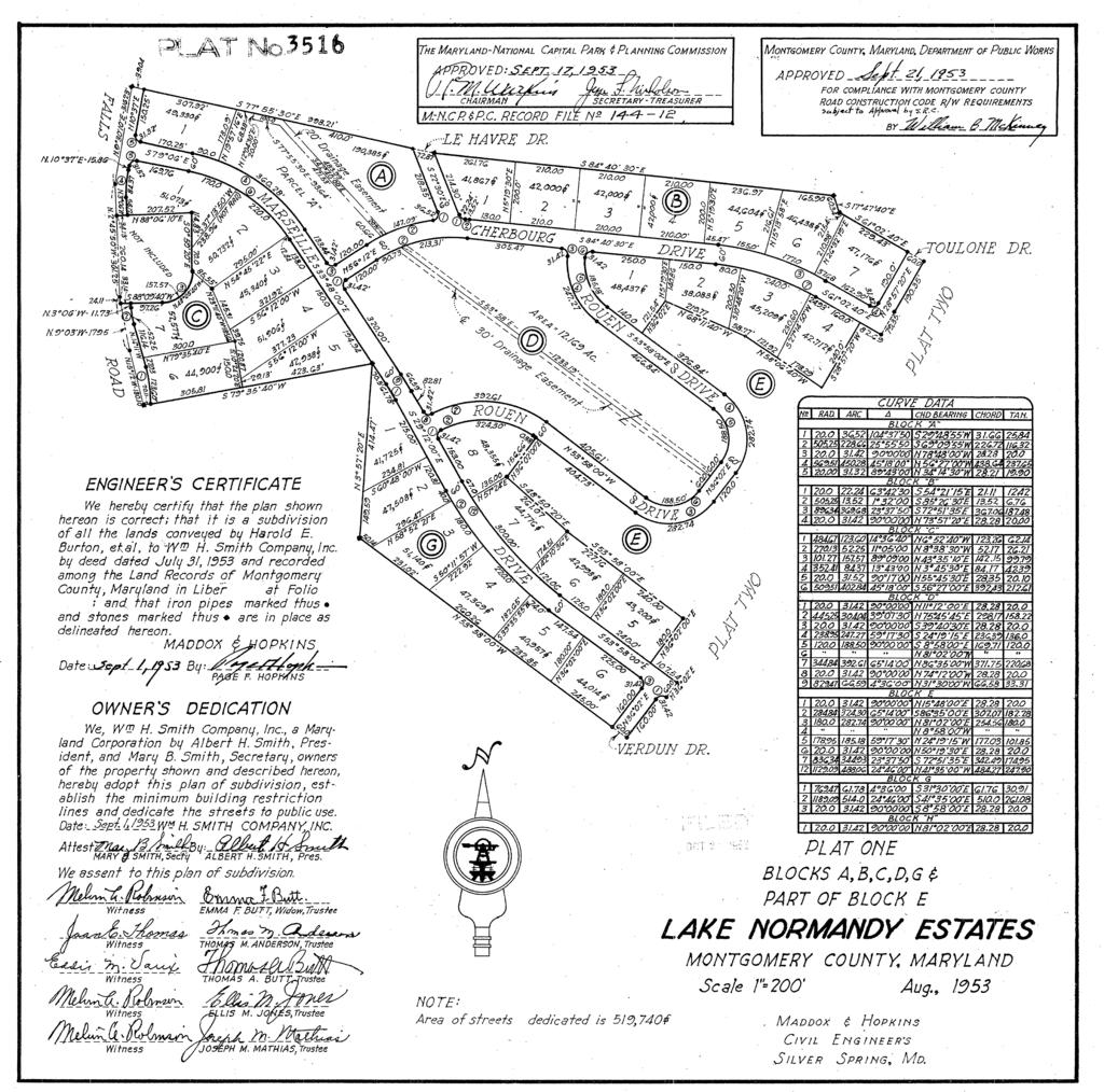
36 Attachment G

37 Attachment H
38 Attachment I
39
40
41
42
43
44
45
46
47
48
49
50
MONTGOMERY COUNTY PLANNING DEPARTMENT THE MARYLAND-NATIONAL CAPITAL PARK AND PLANNING COMMISSION
 MONTGOMERY COUNTY PLANNING DEPARTMENT THE MARYLAND-NATIONAL CAPITAL PARK AND PLANNING COMMISSION MCPB Item No. Date: 12/4/14 Preliminary Plan No. 120140200, Northwood Knolls Description Patrick Butler,
MONTGOMERY COUNTY PLANNING DEPARTMENT THE MARYLAND-NATIONAL CAPITAL PARK AND PLANNING COMMISSION
 MONTGOMERY COUNTY PLANNING DEPARTMENT THE MARYLAND-NATIONAL CAPITAL PARK AND PLANNING COMMISSION MCPB Item No. 3 Date: 01-31-13 Preliminary Plan 120090300, Boyds Highlands Calvin Nelson, Jr. Planner Coordinator,
RECOMMENDATION: Approval subject to the following conditions:
 RECOMMENDATION: Approval subject to the following conditions: 1) Approval under this preliminary plan is limited to 2 lots for 2 dwelling units 2) The record plat must note that the preliminary plan is
MONTGOMERY COUNTY PLANNING DEPARTMENT THE MARYLAND-NATIONAL CAPITAL PARK AND PLANNING COMMISSION
 MONTGOMERY COUNTY PLANNING DEPARTMENT THE MARYLAND-NATIONAL CAPITAL PARK AND PLANNING COMMISSION MCPB Item No. 8 Date: 03-07-13 Sonoma, Preliminary Plan, 120130040 Melissa Williams, Senior Planner, Melissa.williams@montgomeryplanning.org,
MONTGOMERY COUNTY PLANNING DEPARTMENT THE MARYLAND-NATIONAL CAPITAL PARK AND PLANNING COMMISSION
 MONTGOMERY COUNTY PLANNING DEPARTMENT THE MARYLAND-NATIONAL CAPITAL PARK AND PLANNING COMMISSION MCPB Item No.: Date: 06-21-12 The Plantations, Preliminary Plan -120090240 Benjamin Berbert, Senior Planner,
MONTGOMERY COUNTY PLANNING DEPARTMENT THE MARYLAND-NATIONAL CAPITAL PARK AND PLANNING COMMISSION
 MONTGOMERY COUNTY PLANNING DEPARTMENT THE MARYLAND-NATIONAL CAPITAL PARK AND PLANNING COMMISSION MCPB Item No. Date: 10-11-12 Subdivision Review Waiver SRW 2011001: Big Woods Road Richard Weaver, Acting
MONTGOMERY COUNTY PLANNING DEPARTMENT THE MARYLAND-NATIONAL CAPITAL PARK AND PLANNING COMMISSION
 MONTGOMERY COUNTY PLANNING DEPARTMENT THE MARYLAND-NATIONAL CAPITAL PARK AND PLANNING COMMISSION MCPB Consent Item Date: 12/19/13 * Consent Item Barton Property: Preliminary Plan Amendment No. 12011021A
MONTGOMERY COUNTY PLANNING DEPARTMENT THE MARYLAND-NATIONAL CAPITAL PARK AND PLANNING COMMISSION
 MONTGOMERY COUNTY PLANNING DEPARTMENT THE MARYLAND-NATIONAL CAPITAL PARK AND PLANNING COMMISSION MCPB Item No. Date: 10-03-13 Preliminary Plan Amendment No. 11999034B Alvermar Woods, Lot 17 (In Response
MONTGOMERY COUNTY PLANNING DEPARTMENT THE MARYLAND-NATIONAL CAPITAL PARK AND PLANNING COMMISSION
 MONTGOMERY COUNTY PLANNING DEPARTMENT THE MARYLAND-NATIONAL CAPITAL PARK AND PLANNING COMMISSION MCPB Item No. Date: 1-17-13 Preliminary Plan 120110180 - Parmjit & Saini Estates Katherine Holt, Senior
DANAC Stiles Property. Preliminary Plan A
 DANAC Stiles Property Preliminary Plan 11996112A Vicinity Located in the LSC North District of the GSSC Master Plan. Adjacent Uses North: Single-family attached townhouses, R-60 zone; East: Office building,
ARTICLE 23 CONDOMINIUM STANDARDS
 ARTICLE 23 CONDOMINIUM STANDARDS Section 23.01 Intent. The intent of this Article is to provide regulatory standards for condominiums and site condominiums similar to those required for projects developed
MONTGOMERY COUNTY PLANNING DEPARTMENT THE MARYLAND-NATIONAL CAPITAL PARK AND PLANNING COMMISSION
 MONTGOMERY COUNTY PLANNING DEPARTMENT THE MARYLAND-NATIONAL CAPITAL PARK AND PLANNING COMMISSION MCPB Item No. Date: 05-30-13 Pre-Preliminary Plan No. 720130040: Potomac Highlands Callum Murray, supervisor,
TULSA PARK ESTATES SUBDIVISION, RESUBDIVISION OF LOT 6
 TULSA PARK ESTATES SUBDIVISION, RESUBDIVISION OF LOT 6 Engineering Comments: FINAL PLAT COMMENTS (should be addressed prior to submitting the FINAL PLAT for review and/or signature by the City Engineer):
MONTGOMERY COUNTY PLANNING DEPARTMENT THE MARYLAND-NATIONAL CAPITAL PARK AND PLANNING COMMISSION
 MONTGOMERY COUNTY PLANNING DEPARTMENT THE MARYLAND-NATIONAL CAPITAL PARK AND PLANNING COMMISSION Wheaton Woods, Preliminary Plan No. 120160060 MCPB Item No. Date: 02-25-16 Lori Shirley, Planner Coordinator,
PRELIMINARY PLAT CHECK LIST
 PRELIMINARY PLAT CHECK LIST Name of Proposed Subdivision: The following items must be included with the initial submittal of a Preliminary Plat: Application, filled out completely Project Narrative Pre-application
MONTGOMERY COUNTY PLANNING BOARD
 MONTGOMERY COUNTYPLANNING BOARD T H E MARYLAND-NATIONAL CAPITAL PARK A N D P L A N N I N G C O M M I S S I O N MCPB NO. 10-100 Preliminary Plan No. 120100210 Date of Hearing: July 1, 2010 MONTGOMERY COUNTY
Community Development Department 333 Broadalbin Street SW, P.O. Box 490 Albany, OR 97321
 SUMMARY Community Development Department 333 Broadalbin Street SW, P.O. Box 490 Albany, OR 97321 STAFF REPORT Application for Tentative Partition Plat Review Planning File PA-06-17 Phone: 541-917-7550
Montgomery Village - South Valley Park: Subdivision Regulation Waiver SRW , and Site Plan No
 Montgomery Village - South Valley Park: Subdivision Regulation Waiver SRW - 201402, and Site Plan No. 820140070 12 SUBDIVISION REGULATION WAIVER RECOMMENDATION AND CONDITIONS OF APPROVAL Staff recommends
CONCEPTUAL MASTER PLAN CHECKLIST Major Land Development Project
 CONCEPTUAL MASTER PLAN CHECKLIST Major Land Development Project To initiate the application, the applicant shall submit to the Administrative Officer: 1. The application review fee, as established by the
MONTGOMERY COUNTY PLANNING BOARD
 MONTGOMERY COUNTY PLANNING BOARD T H E MARYLAND-NATIONAL CAPITAL PARK A N D P L A N N I N G C O M M I S S I O N MCPB NO. 10-144 Hearing Date: September 30, 2010 MONTGOMERY COUNTY PLANNING BOARD RESOLUTION
APPLICATION FOR MAJOR SUBDIVISION APPROVAL (PRELIMINARY PLAT)
") 209 S. Main Street Marysville, Ohio 43040 Phone: (937) 645-7350 Fax: (937) 645-7351 www.marysvilleohio.org APPLICATION FOR MAJOR SUBDIVISION APPROVAL (PRELIMINARY PLAT) *** IMPORTANT INFORMATION ~ Please
209 S. Main Street Marysville, Ohio 43040 Phone: (937) 645-7350 Fax: (937) 645-7351 www.marysvilleohio.org APPLICATION FOR MAJOR SUBDIVISION APPROVAL (PRELIMINARY PLAT) *** IMPORTANT INFORMATION ~ Please
City of Prior Lake APPLICATION FOR COMBINED PRELIMINARY AND FINAL PLAT
 Case File No. Property Identification No. City of Prior Lake APPLICATION FOR COMBINED PRELIMINARY AND FINAL PLAT Requested Action Brief description of proposed project (Please describe the proposed amendment,
CARROLL COUNTY BUREAU OF DEVELOPMENT REVIEW OFF-CONVEYANCE SUBMITTAL CHECKLIST AND REVIEW FEE SHEET NOTICE: INCOMPLETE SUBMITTALS WILL BE RETURNED
 CARROLL COUNTY BUREAU OF DEVELOPMENT REVIEW OFF-CONVEYANCE SUBMITTAL CHECKLIST AND REVIEW FEE SHEET An off-conveyance submittal shall include all items as specified in Section 103-7 of the Code of Public
Initial Subdivision Applications Shall Include the Following:
 Initial Subdivision Applications Shall Include the Following: 1) Subdivision Application Form: completely filled out (12 copies) 2) Plat: The Plat must adhere to the requirements set forth in the Town
MONTGOMERY COUNTY PLANNING DEPARTMENT THE MARYLAND-NATIONAL CAPITAL PARK AND PLANNING COMMISSION
 MONTGOMERY COUNTY PLANNING DEPARTMENT THE MARYLAND-NATIONAL CAPITAL PARK AND PLANNING COMMISSION MCPB Item No. 9 Date: 9-22-16 Proposed Category Map Amendments: Montgomery County Comprehensive Water Supply
Article Optional Method Requirements
 Article 59-6. Optional Method Requirements [DIV. 6.1. MPDU DEVELOPMENT IN RURAL RESIDENTIAL AND RESIDENTIAL ZONES Sec. 6.1.1. General Requirements... 6 2 Sec. 6.1.2. General Site and Building Type Mix...
MONTGOMERY COUNTY PLANNING DEPARTMENT THE MARYLAND-NATIONAL CAPITAL PARK AND PLANNING COMMISSION
 MONTGOMERY COUNTY PLANNING DEPARTMENT THE MARYLAND-NATIONAL CAPITAL PARK AND PLANNING COMMISSION MCPB Item No.: 4 Date: 2-7-19 Old Angler s Cove, Preliminary Plan No. 120170290 Ryan Sigworth AICP, Senior
Town of Cary, North Carolina Rezoning Staff Report 14-REZ-20 Habitat for Humanity Evans Road Town Council Meeting October 16, 2014
 Town of Cary, North Carolina Rezoning Staff Report 14-REZ-20 Habitat for Humanity Evans Road Town Council Meeting October 16, 2014 REQUEST To amend the Town of Cary Official Zoning Map by rezoning 0.53
Location Map Project: Olshansky Subdivision Applicant: David Olshansky Address: 16965, Cottage Grove Ave Project No a.
 Lake Minnetonka COUNTY ROAD 0 W GRAYS BAY BLVD BAY CIR BAY ST BEECHWOOD AVE Libb's Lake BAY LN BAY LN Subject Property GROVELAND PL CHARMY DNS EDGEWOOD AVE PARK LN GROVELAND SCHOOL RD WOODLAWN AVE PROSPECT
TIMBERLAND PARK 2707 OLNEY-SANDY SPRING ROAD MEDICAL OFFICE/MIXED-USE OLNEY, MARYLAND
 TIMBERLAND PARK 2707 OLNEY-SANDY SPRING ROAD MEDICAL OFFICE/MIXED-USE OLNEY, MARYLAND Exclusively Presented by: Stevan A. Varga ENTRLTY@AOL.COM Stephan A. Varga Stephan@enterpriserealtyservices.com Enterprise
City of Prior Lake APPLICATION FOR PRELIMINARY PLAT
 City of Prior Lake APPLICATION FOR PRELIMINARY PLAT Requested Action Brief description of proposed project (Please describe the proposed amendment, project, or variance request. Attach additional sheets
MONTGOMERY COUNTY PLANNING DEPARTMENT THE MARYLAND-NATIONAL CAPITAL PARK AND PLANNING COMMISSION
 MONTGOMERY COUNTY PLANNING DEPARTMENT THE MARYLAND-NATIONAL CAPITAL PARK AND PLANNING COMMISSION MCPB Item No.: Date: 11-12-15 15931 Frederick Road (CarMax) Annexation Request ANX2015-00145 Patrick Butler,
Gates County Planning and Zoning
 Gates County Planning and Zoning PO Box 411, 200 Court Street, Gatesville, NC 27938 phone: 252-357-2411 fax: 252-357-0073 Application for Technical Review Committee For Staff Use Only: Date: Application
I. Requirements for All Applications. C D W
 108-16.1. Application checklists. Checklist for Required Submissions to the Planning Board or Zoning Board of Adjustment of Monroe Township All required submissions are to be made to the Administrative
City of Prior Lake APPLICATION FOR REGISTERED LAND SURVEY
 Case File No. Property Identification No. City of Prior Lake APPLICATION FOR REGISTERED LAND SURVEY Requested Action Brief description of proposed project (Please describe the proposed amendment, project,
Open Space Model Ordinance
 Open Space Model Ordinance Section I. Background Open space development has numerous environmental and community benefits, including: 1) Reduces the impervious cover in a development. Impervious cover
MINOR & MAJOR SUBDIVISION APPLICATION
 TOW OF HOOKSETT APPLICATIO # DATE MIOR & MAJOR SUBDIVISIO APPLICATIO Application for: Completeness Map and Lot o. Public Hearing o. of Lots LOCATIO: (Specify Street Address) OWER: APPLICAT: ADDRESS: ADDRESS:
SUBDIVISION DESIGN PRINCIPLES AND STANDARDS
 SECTION 15-200 SUBDIVISION DESIGN PRINCIPLES AND STANDARDS 15-201 STREET DESIGN PRINCIPLES 15-201.01 Streets shall generally conform to the collector and major street plan adopted by the Planning Commission
TOWN OF NORTHWOOD, NEW HAMPSHIRE
 TOWN OF NORTHWOOD, NEW HAMPSHIRE OFFICE OF THE PLANNING BOARD 818 First New Hampshire Turnpike, Northwood NH 03261 (603)942-5586 Extension 205 Facsimile: (603)942-9107 Major Subdivision Application Form
Marion County Board of County Commissioners
 Marion County Board of County Commissioners Date: 12/29/2015 P&Z: 12/28/2015 BCC: 1/12/2016 Item Number 160113Z Type of Application Rezoning Request From: A-1 (General Agriculture) To: PUD (Planned Unit
CREEKSIDE TOWNHOMES Chevy Chase, Maryland Site Plan No Preliminary Plan No
 +1 (301) 656 5901 info@nova-habitat.com CREEKSIDE TOWNHOMES Chevy Chase, Maryland Site Plan No. 820160050 Preliminary Plan No. 120160130 Application Statement of Justification October 28, 2015 Nova-Habitat,
MAJOR SUBDIVISION PRELIMINARY PLAT CHECKLIST
 TOWNSHIP OF EGG HARBOR PLANNING BOARD/ZONING BOARD OF ADJUSTMENT 3515 BARGAINTOWN ROAD EGG HARBOR TOWNSHIP, NJ 08234 MAJOR SUBDIVISION PRELIMINARY PLAT CHECKLIST The following checklist is designed to
WESTMINSTER PARK PLACE SUBDIVISION
 WESTMINSTER PARK PLACE SUBDIVISION Engineering Comments: FINAL PLAT COMMENTS (should be addressed prior to submitting the FINAL PLAT for review and/or signature by the City Engineer): A. Provide all of
SECTION 16. "PUD" PLANNED UNIT DEVELOPMENT OVERLAY DISTRICT
 SECTION 6. "PUD" PLANNED UNIT DEVELOPMENT OVERLAY DISTRICT Subsection. Purpose. This district is established to achieve the coordinated integration of land parcels and large commercial and retail establishments
STONE COUNTY PRELIMINARY PLAT CHECKLIST. Note: Applications need to be in the office by 2 p.m. on the cutoff day.
 STONE COUNTY PRELIMINARY PLAT CHECKLIST Note: Applications need to be in the office by 2 p.m. on the cutoff day. JOY WILSON, DIRECTOR Return form to: Planning & Zoning Administrator PO Box 301, Galena,
ZONING VARIANCES - ADMINISTRATIVE
 Planning Department 200 W. Oak Street 3 rd Floor Fort Collins, CO 80521 970-498-7683 www.larimer.org/planning ZONING VARIANCES - ADMINISTRATIVE The submittal requirements listed in this packet are intended
MONTGOMERY COUNTY PLANNING DEPARTMENT THE MARYLAND-NATIONAL CAPITAL PARK AND PLANNING COMMISSION
 MONTGOMERY COUNTY PLANNING DEPARTMENT THE MARYLAND-NATIONAL CAPITAL PARK AND PLANNING COMMISSION MCPB Item No. 6 Date: 9-27-18 Seneca Farms, Preliminary Plan No. 120170240 Jonathan Casey, Senior Planner,
MONTGOMERY COUNTY PLANNING DEPARTMENT THE MARYLAND-NATIONAL CAPITAL PARK AND PLANNING COMMISSION
 MONTGOMERY COUNTY PLANNING DEPARTMENT THE MARYLAND-NATIONAL CAPITAL PARK AND PLANNING COMMISSION MCPB Item No. 3 Date: 05/28/15 Ingleside, Preliminary Plan No. 120140140 Ryan Sigworth AICP, Senior Planner
RIVER VALE MASTER PLAN PZ CITY COUNCIL PUBLIC HEARING JULY 19, 2017 CITY OF BEND
 RIVER VALE MASTER PLAN PZ-16-0954 CITY COUNCIL PUBLIC HEARING JULY 19, 2017 RIVER VALE MASTER PLAN Master Plan process Required for developments over 20 acres Application submitted under old Master Plan
Plans shall be drawn at a readable scale, signed, and sealed by a Florida Registered Engineer. The application package shall include:
 CHAPTER 400. SECTION 403. PERMIT TYPES AND APPLICATIONS SITE DEVELOPMENT 403.3. Preliminary Site Plans (PSP) A. Intent and Purpose PSPs are used to identify existing site conditions and demonstrate general
CHECKLIST FOR DEVELOPMENT REVIEW
 CHECKLIST FOR DEVELOPMENT REVIEW Petitions and related documents and plans for land development or other proposals regulated by Title 16 of the Municipal Code (Development Ordinance) and Title 17 of the
Residential Major Subdivision Review Checklist
 Residential Major Subdivision Review Checklist Plan Submittal Requirements: 2 full sets of stamped plans Electric submittal - all plans contained in a single PDF 3 full sets if commercial kitchen or dining
Implementation. Approved Master Plan and SMA for Henson Creek-South Potomac 103
 Implementation Approved Master Plan and SMA for Henson Creek-South Potomac 103 104 Approved Master Plan and SMA for Henson Creek-South Potomac Sectional Map Amendment The land use recommendations in the
610 LAND DIVISIONS AND PROPERTY LINE ADJUSTMENTS OUTSIDE A UGB
 ARTICLE VI: LAND DIVISIONS AND PROPERTY LINE ADJUSTMENTS VI-21 610 LAND DIVISIONS AND PROPERTY LINE ADJUSTMENTS OUTSIDE A UGB 610-1 Property Line Adjustments (Property Line Relocation) A property line
CERTIFICATION OF THE APPROVAL OF WATER AND SEWERAGE SYSTEMS
 ARTICLE 9 FORMS AND CHECK LISTS 9.100 On preliminary layout & final subdivision plat CERTIFICATION OF THE APPROVAL OF WATER AND SEWERAGE SYSTEMS I hereby certify that the (...type: private or pubic...)
Section Preliminary Plat Checklist and Application Forms
 Section 201 - Preliminary Plat Checklist and Application Forms PRELIMINARY SUBDIVISION PLAT REVIEW PROCESS CHART PRELIMINARY SUBDIVISION PLAT APPLICATION PRELIMINARY PLAT REVIEW CHECKLIST CITY OF NAMPA
WASCO COUNTY PRELIMINARY SUBDIVISION APPLICATION
 WASCO COUNTY PRELIMINARY SUBDIVISION APPLICATION DETAILED SPECIFIC WRITTEN REQUEST File Number: SDV- Number of Proposed Lots & their Dimensions: PRELIMINARY SUBDIVISION PLAN REQUIREMENTS The approval of
MONTGOMERY COUNTY PLANNING DEPARTMENT THE MARYLAND-NATIONAL CAPITAL PARK AND PLANNING COMMISSION
 MONTGOMERY COUNTY PLANNING DEPARTMENT THE MARYLAND-NATIONAL CAPITAL PARK AND PLANNING COMMISSION MCPB Item No. Date: 12/6/12 Limited Site Plan Amendment, 82000018D, DANAC Stiles Property, Lot 6 of Block
TO: Glynn County Islands Planning Commission. Eric Landon, Planner II. PP2754 Stones Throw Cottages. DATE: February 6, 2014
 COMMUNITY DEVELOPMENT DEPARTMENT Planning and Zoning Division 1725 Reynolds Street, Suite 200, Brunswick, GA 31520 Phone: 912-554-7428/Fax: 1-888-252-3726 TO: Glynn County Islands Planning Commission FROM:
WESTMINSTER PARK SUBDIVISION
 WESTMINSTER PARK SUBDIVISION Engineering Comments: FINAL PLAT COMMENTS (should be addressed prior to submitting the FINAL PLAT for review and/or signature by the City Engineer): A. Provide all of the required
Article Floating Zone Requirements
 Division 5.1. In General Article 59-5. Floating Zone Requirements Section 5.1.1. Zone Categories There are 4 categories of Floating zones: A. Residential Floating zones (Division 5.2); B. Commercial/Residential
A. Preserve natural resources as identified in the Comprehensive Plan.
 1370.08 Conservation Residential Overlay District. Subd. 1 Findings. The City finds that the lands and resources within the Conservation Residential Overlay District are a unique and valuable resource
APPENDIX B. SUBMISSION REQUIREMENTS
 Master Major Site Minor Site Landscape Section B.1 Table of /Plat Requirements Proposed or approved name of development, project, subdivision, and/or phase. Location, including township, county, and state.
ARTICLE 7 SUBDIVISION REGULATIONS
 ARTICLE 7 SUBDIVISION REGULATIONS SEE CUSTOMER ASSISTANCE GUIDE ENTITLED, "HOW TO SUBDIVIDE PROPERTY", AVAILABLE FROM THE DEPARTMENT OF PLANNING & ZONING, FOR ADDITIONAL INFORMATION. Article 7 Page No.
DEPARTMENT OF PLANNING JEFFERSON PARISH, LOUISIANA
 DEPARTMENT OF PLANNING JEFFERSON PARISH, LOUISIANA SUBDIVISION REPORT DOCKET NO: ES-1-17-PF SUMMARY NO.: COUNCIL DISTRICT: 2 Paul D. Johnston COUNCIL AT LARGE: A: Christopher L. Roberts B: Cynthia Lee-Sheng
City and County of Broomfield, Colorado
 City and County of Broomfield, Colorado CITY COUNCIL AGENDA MEMORANDUM To: From: Mayor and City Council George Di Ciero, City and County Manager Teri Malies, Principal Planner Terrance Ware, Planning Director
MONTGOMERY COUNTY PLANNING DEPARTMENT THE MARYLAND-NATIONAL CAPITAL PARK AND PLANNING COMMISSION
 MONTGOMERY COUNTY PLANNING DEPARTMENT THE MARYLAND-NATIONAL CAPITAL PARK AND PLANNING COMMISSION MCPB Item No. 5 Date: 12-15-16 Bradford s Landing, Preliminary Plan, 120170060 Description Sandra Pereira,
Planned Residential Development ( PRD ) Application
 Application") FOR PLANNING USE ONLY Application # PRD Application Fee $ Receipt No. Filing Date Completeness Date Planned Residential Development ( PRD ) Application A. PROJECT INFORMATION 1. Project Name: 2. Address
FOR PLANNING USE ONLY Application # PRD Application Fee $ Receipt No. Filing Date Completeness Date Planned Residential Development ( PRD ) Application A. PROJECT INFORMATION 1. Project Name: 2. Address
FINAL PLAN CHECKLIST
 FINAL PLAN CHECKLIST Subdivision Name: Subdivision Number: Project Number: REVIEW CRITERIA Plans: A final plan shall be on a 24 x 36 sheet at a scale that is no smaller than 1 = 40 and shall contain all
Preliminary Plan
 The Maryland-National Capital Park and Planning Commission Prince George's County Planning Department Development Review Division 301-952-3530 Note: Staff reports can be accessed at www.mncppc.org/pgco/planning/plan.htm.
STAFF REPORT. Applicable Statutes/Ordinances: Corinna Township Subdivision Ordinance
 STAFF REPORT Application: Preliminary plat application to subdivide an approximate 6.47 acre parcel into two lots (2.81 and 3.42 acres) with a 0.24 acre remainder to be attached to an existing nonconforming
Town of Cary, North Carolina Rezoning Staff Report 13-REZ-13 An Zou Property Town Council Meeting November 21, 2013
 Town of Cary, North Carolina Rezoning Staff Report 13-REZ-13 An Zou Property Town Council Meeting November 21, 2013 REQUEST To amend the Town of Cary Official Zoning Map by rezoning 0.63 acres located
DEPARTMENT OF CITY PLANNING. Recommendation Report. Central Area Planning Commission. Case No.: CEQA No.: Incidental Cases: Related Cases:
 DEPARTMENT OF CITY PLANNING WtoEl Recommendation Report Central Area Planning Commission Case No.: CEQA No.: Incidental Cases: Related Cases: Date: August 23, 2016 Time: After 4:30 p.m.* None Place: Los
STAFF REPORT. Permit Number: Unlimited. Kitsap County Board of Commissioners; Kitsap County Planning Commission
 STAFF REPORT Permit Number: 15 00550 Unlimited DATE: March 2, 2016 TO: FROM: Kitsap County Board of Commissioners; Kitsap County Planning Commission Katrina Knutson, AICP, Senior Planner, DCD and Jeff
Town of Cary, North Carolina Rezoning Staff Report 14-REZ-31 Cary Park PDD Amendment (Waterford II) Town Council Meeting January 15, 2015
 Town Council Meeting January 15, 2015") Town of Cary, North Carolina Rezoning Staff Report 14-REZ-31 Cary Park PDD Amendment (Waterford II) Town Council Meeting January 15, 2015 REQUEST To amend the Town of Cary Official Zoning Map by amending
Town of Cary, North Carolina Rezoning Staff Report 14-REZ-31 Cary Park PDD Amendment (Waterford II) Town Council Meeting January 15, 2015 REQUEST To amend the Town of Cary Official Zoning Map by amending
Dane County Planning & Development Land Division Review
 Dane County Planning & Development Land Division Review Date: June 26, 2012 To: Zoning & Land Regulation Committee From: Daniel Everson, Land Division Review Re: Revere Trails (preliminary plat) Town of
Residential Minor Subdivision Review Checklist
 Residential Minor Subdivision Review Checklist Plan Submittal Requirements: 2 full sets of stamped plans Electric submittal - all plans contained in a single PDF 3 full sets if commercial kitchen or dining
CODE OF ALLEGANY COUNTY MARYLAND. Chapter 141 Part 1 Subdivision Regulations
 CODE OF ALLEGANY COUNTY MARYLAND Chapter 141 Part 1 Subdivision Regulations [Added 12-12-1996] **Un-Official Text** 141-1. Legislative purpose. ARTICLE I General Provisions A. Purpose. This Part 1 is to
PRELIMINARY PLAN CHECKLIST Major Land Development Projects. To initiate the application, the applicant shall submit to the Administrative Officer:
 PRELIMINARY PLAN CHECKLIST Major Land Development Projects To initiate the application, the applicant shall submit to the Administrative Officer: 1. The application review fee, as established by the South
ARTICLE IV: DEVELOPMENT STANDARDS
 ARTICLE IV: DEVELOPMENT STANDARDS IV-53 409 PRIVATE STREETS A private street means any way that provides ingress to, or egress from, property by means of vehicles or other means, or that provides travel
MONTGOMERY COUNTY PLANNING BOARD
 APR :7 20m MONTGOMERY COUNTY PLANNING BOARD THE MARYLAND-NATIONAL CAPITAL PARK AND PLANNING COMMISSION MCPB No. 10-172 Date of Hearing: December 9, 2010 MONTGOMERY COUNTY PLANNING BOARD RESOLUTION WHEREAS,
-MENDOCINO COUNTY PLANNING AND BUILDING SERVICES- DIVISION OF LAND REGULATIONS TITLE 17
 ARTICLE VI -- GENERAL REGULATIONS AND PROVISIONS Sec. 17-50. Sec. 17-51 General Plan. Sec. 17-52 Lot and Block Design and Configuration. Sec. 17-53 Lot Access. Sec. 17-54 Private Roads. Sec. 17-55 Water
Chapter Planned Residential Development Overlay
 Chapter 19.29 Planned Residential Development Overlay Sections 010 Purpose 020 Scope 030 Definitions 030 Minimum Size 040 Allowable Uses 050 Minimum Development Standards 060 Density Bonus 070 Open Space
6.1 SCHEDULE OF AREA, FRONTAGE, YARD AND HEIGHT REQUIREMENTS
 SECTION 6.0 6.1 SCHEDULE OF AREA, FRONTAGE, YARD AND HEIGHT REQUIREMENTS Minimum Minimum Minimum Minimum Minimum Maximum Maximum Lot Lot Front Side Rear Height Lot District Area Front Yard Yard Yard Coverage
WHEREAS, the staff of The Maryland-National Capital Park and Planning Commission recommended APPROVAL of the application with conditions; and
 R E S O L U T I O N WHEREAS, F.M. and M.B. Hall are the owners of a 17.60-acre parcel of land known as Lots 1-3, Block O; Lots 1-11, Block P; and Parcel B and part of Parcel A, being located on Tax Map
Review of Land Divisions in Open Space and Residential Zones 660
 Title 33, Planning and Zoning Chapter 33.660 5/24/18 Review of Land Divisions in Open Space and Residential Zones 33.660 Review of Land Divisions in Open Space and Residential Zones 660 Sections: General
MONTGOMERY COUNTY PLANNING DEPARTMENT THE MARYLAND-NATIONAL CAPITAL PARK AND PLANNING COMMISSION
 MONTGOMERY COUNTY PLANNING DEPARTMENT THE MARYLAND-NATIONAL CAPITAL PARK AND PLANNING COMMISSION MCPB Item No. Hearing Date: 10/8/15 Howard Hughes Medical Institute, Limited Amendment of the Preliminary
CONCEPT PLAN SUBMISSION REQUIREMENTS:
 STAFF STRONGLY RECOMMENDS A PRE-DEVELOPMENT MEETING BEFORE THE SUBMITTAL OF ANY APPLICATION FOR ZONING, REZONING, CONDITIONAL USE PERMIT (CUP), OR FOR A TEXT AMENDMENT TO A PROVISION(S) OF THE ZONING ORDINANCE.
Article 04 Single Family Residential Districts
 Article 04 Article 04 Section 04.01 Intent (a) R1A Residence District. The R1A Single Family Residential District is established to include areas of low density single-family residences and limited agricultural
CITY OF OAK HARBOR Development Services Department
 CITY OF OAK HARBOR Development Services Department Shortt Subdiiviisiions Shorrtt Pllatt Reviiew Prrocess IIII What is a Short Plat, and when is it necessary? A short plat is a map that represents a short
M-43 CORRIDOR OVERLAY ZONE
 ARTICLE 26.00 M-43 CORRIDOR OVERLAY ZONE Section 26.01 Findings A primary function of the M-43 state highway is to move traffic through the Township and to points beyond. As the primary east-west arterial
CITY OF OCOEE LAND DEVELOPMENT CODE SUFFICIENCY TABLE WITH NOTES
 CITY OF OCOEE LAND DEVELOPMENT CODE SUFFICIENCY TABLE WITH NOTES The Sufficiency Table is a checklist to help identify the types of information and documentation needed for various types of projects. The
ARTICLE III GENERAL PROCEDURES, MINOR PLANS AND FEE SCHEDULES
 ARTICLE III GENERAL PROCEDURES, MINOR PLANS AND FEE SCHEDULES 301. Prior to Submission a. Copies of this Ordinance shall be available on request, at cost, for the use of any person who desires information
DEVELOPMENT PLAN REVIEW CHECKLIST. To initiate the application, the applicant shall submit to the Administrative Officer:
 DEVELOPMENT PLAN REVIEW CHECKLIST To initiate the application, the applicant shall submit to the Administrative Officer: 1. Sixteen (16) copies of the Project Review Application Form, printed double-sided;
AN ORDINANCE AMENDING THE CODE OF ORDINANCES OF THE TOWN OF TRYON. Chapter 156 Subdivision Ordinance
 AN ORDINANCE AMENDING THE CODE OF ORDINANCES OF THE TOWN OF TRYON Chapter 156 Subdivision Ordinance Chapter 156: Subdivision Regulations ARTICLE I GENERAL PROVISIONS Section 1.1 Title This Ordinance shall
AGENDA CITY OF EL MONTE MODIFICATION COMMITTEE TUESDAY OCTOBER 23, :00 P.M. CITY HALL WEST CONFERENCE ROOM A VALLEY BOULEVARD
 AGENDA CITY OF EL MONTE MODIFICATION COMMITTEE TUESDAY OCTOBER 23, 2018 CITY OF EL MONTE MODIFICATION COMMITTEE CHAIRPERSON AMY WONG CITY PLANNER JASON C. MIKAELIAN CHIEF BUILDING OFFICIAL TODD MORRIS
DOUGLAS COUNTY SUBDIVISION RESOLUTION Article 4 Preliminary Plan 10/13/2015
 ARTICLE 4 PRELIMINARY PLAN 401 Intent An in-depth analysis of the proposed subdivision, including a review of the design considering the ability to obtain water and sanitation, identified geologic hazards,
ZONING VARIANCES ADMINISTRATIVE
 200 W. Oak Street, 3rd Floor Fort Collins, CO 80521 (970) 498-7683 / larimer.org/planning ZONING VARIANCES ADMINISTRATIVE The submittal requirements listed in this packet are intended to collect all of
March 6, The County Board of Arlington, Virginia. Ron Carlee, County Manager
 March 6, 2003 TO: FROM: SUBJECT: The County Board of Arlington, Virginia Ron Carlee, County Manager Zoning Ordinance amendments to Section 1. Definitions, Section 31. Special Exceptions and Section 32.
FINAL SUBDIVISION AND LAND DEVELOPMENT PLAN CHECKLIST. Plan Name. Applicant's Name:
 TOWNSHIP OF UPPER ST. CLAIR FINAL SUBDIVISION AND LAND DEVELOPMENT PLAN CHECKLIST Date Filed Plan Name PLC Applicant's Name: Phone Filing Date for Final Application Final Plat 114.22. FINAL APPLICATION