MONTGOMERY COUNTY PLANNING DEPARTMENT THE MARYLAND-NATIONAL CAPITAL PARK AND PLANNING COMMISSION
|
|
|
- Simon Higgins
- 6 years ago
- Views:
Transcription
1 MONTGOMERY COUNTY PLANNING DEPARTMENT THE MARYLAND-NATIONAL CAPITAL PARK AND PLANNING COMMISSION MCPB Item No. xxxxx Date: Hoyt Property, Preliminary/Site Plan, / Tina Schneider, Senior Planner, Area 1, Robert Kronenberg,, Area 1, Description Date of Report: Preliminary Plan Site Plan Location: 5400 Butler Road, Bethesda, MD Zone: RT-15 Master Plan: Westbard Sector Plan, 1982 Property size: 1.81 acre site (78,935 sq.ft.) Proposal: Construct 30 townhouse lots, including 5 MPDUs including waivers to building setbacks and row design Applicant: EYA Development, LLC Filing Date: February, 27, 201 Summary Staff Recommendation: Approval with conditions of the Preliminary Plan, Site Plan, and Forest Conservation Plan. The Applicant proposes to redevelop an industrial site into 30 three-story townhouses with 5 moderately priced dwelling units (MPDUs) under the optional method. The property was rezoned from the I-1 to the RT-15 zone by a local map amendment approval by the Montgomery County District Council pursuant to Resolution on September 27, The townhomes will be arranged along both sides of a private drive that will access the site from Little Falls Parkway, as recommended in the Westbard Sector Plan. Primary access was achieved through a Park easement from Little Falls Parkway, a private Park road. Little Falls Parkway prohibits commercial vehicles thus a secondary access off of Butler Road will solely be for commercial vehicles and the residents. A sensory gate and signage will restrict through-passers. The development will provide a public connection from Little Falls Parkway to the adjacent Capital Crescent Trail (CCT). The Preliminary and Site Plan conforms to all binding and nonbinding elements required by the Hearing Examiner under Section 59-D The Applicant is requesting two waivers for a reduction in the property line setbacks ( 59-C-1.732) and to the row design standards for the maximum number of townhouse units in a row ( 59-C-1.722). Staff supports both waiver requests. 1
2 TABLE OF CONTENTS SECTION 1: CONTEXT & PROPOSAL Site Description 3 Vicinity 3 Site Analysis 4 Project Description 5 Previous approvals 5 Proposal 5 Community Outreach 7 SECTION 2: PRELIMINARY PLAN REVIEW 7 Analysis and Findings 8 Recommendation and Conditions 17 SECTION 3: SITE PLAN REVIEW 19 Findings 19 Recommendation and Conditions 29 APPENDICES 33 ILLUSTRATIONS & TABLES Vicinity Map 3 Aerial Photograph 4 Illustrative Site Plan 6 Preliminary Plan 7 Site Plan Data Table 24 Illustrative rendering of the open spaces and amenity areas 26 Recreation Calculations Tables 27 2
, and Euromotors Car Center and Martin s Volvo dealership to the north.")
3 SECTION 1: CONTEXT AND PROPOSAL SITE DESCRIPTION Vicinity The subject property is located just outside the Westbard commercial area in close proximity to the Friendship Heights Central Business District. The 1.81-acre site adjoins the Capital Crescent Trail to the west (elevated above the site), and Euromotors Car Center and Martin s Volvo dealership to the north. To the south and east is Little Falls Stream Valley Park. Approximately 90 feet east of the site is Little Falls Parkway. The Westbard commercial area is generally located west of the site, while an area of onefamily detached homes is generally located east of the site. The site is currently classified in the RT-15 residential townhouse zone, and is identified as P513 on Tax Map HM 123. The land use and zoning pattern of the surrounding area is diverse. The Westbard commercial area is to the north and west of the site. Here, land uses are mixed, with higher density residential buildings and commercial shopping venues in place under C-0, C-1 and C-4 zoning. Many industrial uses under the I-1 Zone line Butler Road to the north of the site. Parkland immediately surrounds the remaining three sides of the site, all within the R-60 Zone. One-family residential homes are further east, also in the R-60 Zone. A generalized outline of the surrounding area is shown below. Subject Property 1.81 Acres R-T 15 3

4 Vicinity Map Site Analysis The subject property is located at 5400 Butler Road, Bethesda, Maryland. The property was recently rezoned from the I-1 to the RT-15 zone. The site is surrounded by Montgomery County M-NCPPC parkland to the east, south and west, and is adjacent to industrial land to the north. The site is relatively flat with retaining walls and steep slopes along the periphery.. The property is at the extreme down-slope of the Willet Branch of the Little Falls watershed, which is classified by the State of Maryland as Use I waters and has a two square mile drainage area covering portions of Bethesda. The 2003 update of the Countywide Stream Protection Strategy (Montgomery County Department of Environmental Protection) identifies the property as poor water quality. The site will be served by municipal water and sewer. The stream runs adjacent to the western boundary of the site; the associated stream valley buffer encompasses a large portion of the property and includes a 100-year floodplain. The Property currently houses the BETCO block plant which consists of a complex of buildings comprising about 29,370 square feet and a large paved area for parking and storage which virtually covers the site. There is significant encroachment from the existing concrete block factory onto the adjacent parkland. In addition to tree and slope impacts, rubble has been disposed of onto parkland. Groundwater monitoring was performed by Apex Companies, LLC to determine if contaminants were found on and off-site. Laboratory data indicate that total petroleum hydrocarbons and diesel range organics (TPH- GRO/DRO) were discovered on parkland and within the project boundaries. Aerial Photo with approximate site boundary outlined in red 4
5 The present Federal Emergency Management Area (FEMA) 100-year floodplain line now traverses a small portion of the property along the western border. The floodplain buffer crosses over the proposed stormwater management facility and a corner of townhouse #21. The Applicant contests that floodplain line is confined to the existing trapezoidal concrete channel within parkland, and not within the Applicant s property. A revision to the existing FEMA 100-year floodplain map has been initiated but as of the date of this report has not yet been granted by FEMA. Prior to FEMA approval, the Department of Permitting Services (DPS) must find the new floodplain line acceptable, which it did on April 16, FEMA approval is anticipated and must be granted prior to the record plat. PROJECT DESCRIPTION Previous Approvals The property was rezoned from the I-1 to the RT-15 zone by a local map amendment approved by the Montgomery County District Council pursuant to Resolution on September 27, The District Council found that the Schematic Development Plan proposal was consistent with the September 1982 Westbard Sector Plan and provided an appropriate transition which was compatible with the adjacent neighborhood. The binding elements are outlined in Section 2: Site Plan Review, on page XXX. Proposal The Applicant intends to raze the existing cinder block plant and replace it with a townhouse community of 30 units, including 5 MPDUs (16.6%). The townhomes will be arranged along both sides of the private driveway that accesses the site from Little Falls Parkway. Once developed, approximately 38% of the site will be green area, as contrasted from today s existing condition of complete impervious cover. The lot layout shown on the preliminary and site plan drawings nominally differs from the layout which was shown on the Schematic Development Plan and conforms to all the binding elements. The Hoyt property is adjacent to Parkland on three sides (east, west, and south). There is no public access the site, therefore, access had to be granted through a Park easement. Along with the easement other conditions include enhancing the existing park setting by providing shared amenities with the proposed development, removing existing encroachments and associated contamination while minimizing natural resource impacts, managing long term maintenance of shared amenities on parkland, minimizing disturbance on parkland, and eliminating potential hazards created by the proposed development in close proximity with natural resources. Access to the site for the residents will be chiefly provided from Little Falls Parkway in accordance with an access easement from the Parks Department. Access for commercial vehicles is restricted on Little Falls Parkway and will be provided via Butler Road. Just after crossing the park easement, a landscaped open space with an outdoor eating area and benches near the entry. A 5-foot wide sidewalk/trail connection will be provided as a direct connection from the Little Falls Parkway to the Capital Crescent Trail (CCT). The street network and associated sidewalk and trail system will provide adequate vehicular and pedestrian circulation. 5

6 There will be sufficient parking on the site. The applicant provides the necessary parking consistent with the zoning ordinance and exceeds the number of parking spaces provided in the zoning case. Parking is further evaluated in the finding section of the site plan. The project has a contemporary, urban flavor with large glass windows and balconies to take advantage of the views to parkland. The façade will be stone, wood and glass to add a modern flair. The townhomes will be three stories with a maximum height of 35-feet, with front loading garages onto Private Street A and B. The streetscape will be modern but quaint with pavers and lanterns. The chosen native plant material will provide seasonal interest in both color and texture complimenting the building facades as well as providing privacy screening and accenting various site amenities. A live privacy wall is proposed to help screen the adjacent commercial property o the north. Green Area The green area provided is thirty eight (38) percent exceeding the minimum thirty (30) percent requirement by eight (8) percent. A park picnic bench and lawn is combined with the biofiltration facility area. Two benches will be located to the northwest of the stormwater management facility within a vegetated sitting area with views to the Willett Branch stream valley buffer and parkland. Another seating area is proposed at the base of the stairs leading to the CCT. A planted stream valley buffer on Parkland abuts the seating area to provide additional offsite green area. 6 Illustrative site plan
7 An important subject of the application has been the Easement Agreement with the Parks Department that allows access to the site across parkland from Little Falls Parkway. The Agreement included various public amenity projects such as a stream buffer planting, encroachment mitigation, channel restoration, geotechnical monitoring, retaining wall construction, and a few other outstanding Conditions outlined in appendix 1. An important subject of the application has been the Easement Agreement with Parks that allows access to the site across parkland from Little Falls Parkway. The Agreement included various public amenity projects such as a stream buffer planting, encroachment mitigation, channel restoration, geotechnical monitoring, retaining wall construction, and a few others that are specified in Conditions. FEMA approval of the changes to the 100-year floodplain line is needed prior to the Planning Board approval of the record plat. The Applicant is also requesting a waiver to the minimum setbacks and to the row design standards for townhouses. Both waivers are discussed in detail in the Site Plan findings section and supported by Staff. Community Outreach The Applicant held several public meetings in connection with the rezoning. The Applicant also held the required pre-submission meeting at the Little Falls Community Library on November 15, Staff has not received any correspondence from the public. SECTION 2: PRELIMINARY PLAN REVIEW Preliminary Plan 7
8 ANAYSIS AND FINDINGS Master Plan Conformance The preliminary plan for the Hoyt Property conforms to the recommendations in the September 1982 Westbard Sector Plan. The Sector Plan makes specific recommendations for a townhouse development on this Property. On September 27 th, 2011, with a unanimous Board approval, the Montgomery County District Council (Resolution ) approved rezoning the property to an R-T 15 Zone. Although exceeding the recommendation in the sector plan, it was granted in part due to the surrounding land uses and large amounts of nearby parkland, the transitional nature of this project in relation to the higher residential densities to the west. The furtherance of County planning policies such as the redevelopment of brownfield sites, the removal of environmental encroachments, contamination clean up, and the provision of affordable housing above the requirement, also contributed to the rezoning of the property. Many secondary recommendations for the site are discussed throughout the Sector Plan and listed pointby-point below: On pages , the Sector Plan recommends the improvement of stormwater management on the site. The site presently consists of impervious surfaces and steep slopes on the adjacent Parkland with no stormwater management. Currently, all stormwater discharge flow is untreated into Willett Branch. Therefore redevelopment under current stormwater management regulations will readily achieve the master plan recommendations for this project related to storm water management. The applicant will be required to provide modern stormwater facilities using best management practices. On pages , the Sector Plan identifies excessive noise levels generated from numerous sources reaching within the property. Noise levels from the proposed residential uses are anticipated to be lower than the current noise levels from the present industrial land use. A noise study was submitted and reviewed indicating impacts above the 65 dba for the rear of units 1 and The applicant is requesting that the Board find that the noise levels for impacts above the 65 dba (projected to be at 66 dba) are minimal and not necessary given the proximity to a parkway setting, current restriction for commercial vehicles on the parkway and residential use that is proposed to replace the current industrial operation. On page 107 of the Sector Plan construction on excessively steep slopes is discouraged. The original topography was altered creating walls and even steeper slopes than those that existed previously. Redevelopment of the site and removal of encroachments will provide an opportunity to stabilize the slopes along the eastern and western property boundaries where the slopes are the steepest and impacts are significant. On page 107, the Plan recommends minimizing the extent of impervious areas. Currently, the site is ninety-four (94) percent impervious. The proposed plan reduces impervious to sixty-four (64) percent. Open space will be thirty-eight (38) percent. On numerous pages throughout the Plan (see pages 21, 24, 28, and 52), the Plan articulates that site redevelopment for townhomes is appropriate provided that a separate entrance to the site can be achieved via Little Falls Parkway. A conceptual illustration of suggested approaches on 8
9 page 24 furthers the Plan s narrative, showing access to the site from Little Falls Parkway, with Butler Road truncating before reaching the subject property. The Sector Plan narrative and illustration provides a basis to interpret that the intent of the Plan for the proposed development scenario included the option of restricting access to the site from all roads except Little Falls Parkway. However, given the prohibition that is in place for commercial vehicles on Little Falls Parkway, the applicant is proposing secondary access to the site from Butler Road. The Applicant is proffering to restrict this access for the exclusive use of commercial vehicles serving the development. Given the above analysis, the proposal substantially conforms to the Plan s guidance of replacing the existing industrial brownfield site with a residential townhouse community. By replacing the brownfield site with a residential, one-family development, the residential character of the area is enhanced and a transition between the Westbard commercial area and the residential one-family detached neighborhood to the east is provided. TRANSPORTATION Circulation The roadway network has been evaluated by Staff and the Montgomery County Department of Fire and Rescue Services (MCFRS). The Montgomery County Department of Transportation (MCDOT) was included in the Development Review Committee (DRC), however, access to the site through both Little Falls Parkway and Butler Road are private roads not under the jurisdiction of MCDOT. The private roads associated with the site are determined adequate and sufficient. On-Site Parking As stated above, there will be ample parking on the site. The Applicant included a binding element in the rezoning committing to 2 garage spaces per unit for market rate units and 1 space for MPDUs, plus an additional dedicated parking space for at least two of the MPDUs, as well as a minimum of 8 additional non-driveway parking spaces to be located on the site. The site plan proposes 55 garage spaces to serve the 30 units, two dedicated parking space for 2 MPDU units, and 14 visitor parking spaces for a total of 71 spaces. The site plan is consistent with the Schematic Development Plan for the unit parking and provides 15 additional visitor parking spaces on Private Street A and parallel spaces on Private Street B. In addition nine (9) units can accommodate additional standard parking space in the driveway. This surpasses the two parking spaces for each dwelling unit required under Section 59-E-3.7 of the Ordinance. Available Transit Service The immediate area is served by metro bus route T2 (along River Road) and Ride-On route 23 (along River Road and Westbard Avenue). 9
10 Pedestrian and Bicycle Facilities The applicant is proposing to install a 5-foot wide stamped sidewalk along the east, west, and south sides of the interior private streets (streets A & B). The walkway connects to a 5-foot asphalt trail that starts at Little Falls Parkway and leads through parkland to the CCT. The Park property has a severe slope of 25 percent requiring stairs. The stairs will have a hand rail on both sides of the steps with a center bicycle channel for porting bicycles up or down the steps. There will be two (2) benches at the base of the stairs and a bicycle rack. ADEQUATE PUBLIC FACILIITES REVIEW A traffic statement and Policy Area Mobility Review (dated March 9, 2011; Revised May 11, 2012) prepared by the traffic consultant for the Applicant and was submitted for the subject application per the LATR/PAMR Guidelines since the proposed development was estimated to generate less than 30 peak-hour trips during the typical weekday morning (6:30 a.m. 9:30 a.m.) and evening (4:00 p.m. 7:00 p.m.) peak periods. Trip Generation The peak-hour trip generation estimate for the proposed development was based on trip generation rates included in the LATR/PAMR Guidelines. A site trip generation summary is provided in Table 1, which shows that the development would generate 14 peak-hour trips during weekday morning peak period and 25 peak-hour trips during the weekday evening peak period. Local Area Transportation Review (LATR) Since the proposed development will not generate 30 or more peak-hour trips during the weekday morning and evening peak periods, a traffic study is not required for the application. With documentation of site trip generation as above, the application satisfies the LATR requirements of the APF test. Table 1: Summary of Site Trip Generation Proposed Trip Generation Morning Peak-Hour Evening Peak-Hour In Out Total In Out Total 30 single-family attached (townhouse) units Wells and Associates, Inc. Hoyt Property, Traffic Statement and Policy Area Mobility Review; March 9, 2011; Revised May 11, Policy Area Mobility Review (PAMR) To satisfy the PAMR requirements of the APF test, a development located within the Bethesda/Chevy Chase Policy Area is required to mitigate 25% of new peak-hour trips generated by the development. The site trip generation summary presented above shows that the development will generate 25 peakhour trips during the weekday evening peak period (highest of the peak-hours). With credit for two (2) peak-hour trips at the existing block manufacturing plant and the PAMR requirement to mitigate 25% of 10
11 the new trips, the development is therefore required to mitigate six (6) peak-hour trips (i.e., (25 2) x 0.25 = 6). The Applicant is proposing to satisfy the PAMR mitigation requirements of the APF test by paying $70, to MCDOT (to mitigate six weekday peak-hour trips at $11, per peak-hour trip). Other Public Facilities Public facilities and services are available and will be adequate to serve the proposed development. The property will be served by public water and sewer systems. The application has been reviewed by the Montgomery County Fire and Rescue Service and they have determined that the property has appropriate access for fire and rescue vehicles. Electrical and telecommunications services are also available to serve the Property. Washington Suburban Sanitary Commission recommends approval based upon the local lines that exist, and are of adequate size to serve the proposed number of homes. Montgomery County Public Schools estimates the impact of the proposed development to be approximately eight elementary school students, four middle school students, and four high school students. Enrollments at Westbrook Elementary School, Westland Middle School, and Bethesda Chevy- Chase High School are all over capacity. In accordance with the 2012 Subdivision Staging Policy a school facilities payment will be required at all three levels. ENVIRONMENTAL GUIDELINES Natural Resources Inventory The Hoyt Property site has a Natural Resource Inventory/Forest Stand Delineation (NRI/FSD) plan # , which was approved on June 30, Forest area is located within the parkland, immediately adjacent to the site along the southern boundary. Tree stands not meeting forest definition have established along and within the site perimeter. However, no forest area and no significant or specimen trees are located on the site. The NRI/FSD and associated documents can be view at the link below: The site is adjacent to a perennial stream within the Little Falls Use I-P watershed. A stream valley buffer (SVB) is located on approximately half of the property. An area of highly erodible soils occurs along the Capital Crescent Trail and within portions of the site and within other areas of the adjacent parkland. The site is not within a Special Protection Area (SPA). Based on the Environmental Guidelines the areas within the SVB are typically placed within protected Category I conservation easements. Given the existing impervious surfaces, the approved Sector Plan recommendations for townhouse development of the subject property, and the existing and proposed access which must occur through the SVB, staff supports the redevelopment within the SVB. A minor area of Category I conservation easement is proposed at the southern end of the property. Staff has included a recommended condition to modestly expand the easement area while still allowing free 11
12 and clear maintenance/access around the adjacent lot, leaving a comparable access to those proposed in other portions of the site. Forest Conservation Plan This property is subject to the Chapter 22A Montgomery County Forest Conservation Law and a Final Forest Conservation Plan has been submitted for approval (stamped received on May 22, 2012). The townhouse development will require that the afforestation requirements are met onsite [under 22A- 12(f)(2)(D) of the forest conservation law]. The onsite boundary area is 1.81 acres in size and contains no forest. However, there is an afforestation requirement of 0.27 acres which will be met onsite by a combination of canopy credit for various plantings and the credit for the Category I conservation easement area. Staff has included recommended conditions to ensure the forest conservation requirements are appropriately satisfied. Tree Save Plan There are seven trees measuring 30 DBH identified within the study area for the project. Numerous trees not subject to the forest conservation variance, such as those within the 24 < 30 size class and smaller also occur within the study area. Some of these smaller trees are also affected by the work. The current plans include provisions for tree preservation measures. A condition is recommended that an International Society of Arboriculture (ISA) certified arborist sign the plans to ensure the tree save component is feasible. In all cases where impacts are proposed, appropriate trees preservation/stress reduction measures will be performed under the supervision an appropriate tree care professional. Refer to the variance section below for further information. Forest Conservation Variance Section 22A-12(b) (3) of Montgomery County Forest Conservation Law provides criteria that identify certain individual trees as high priority for retention and protection. Any impact to these trees, including removal of the subject tree or disturbance within the tree s critical root zone (CRZ), requires a variance. An Applicant for a variance must provide certain written information in support of the required findings in accordance with Section 22A-21 of the County Forest Conservation Law. Unless the variance is granted, the law requires no impact to trees that measure 30 inches DBH or greater; are part of a historic site or designated with a historic structure; are designated as national, state, or county champion trees; are at least 75 percent of the diameter of the current State champion tree of that species; or to trees, shrubs, or plants that are designated as Federal or State rare, threatened, or endangered species. Since the project boundary affects trees that are 30 DBH, a variance is required. The Applicant submitted a variance request on May 23, 2012 for the impacts to, and removal of trees as a result of the proposed project (see Attachment B-2 for variance request). The applicant proposes to remove five trees that are 30 DBH, and to impact, but not remove, two other subject trees. In total, seven trees are that are considered high priority for retention under Section 22A-12(b) (3) of the County Forest Conservation Law are proposed to be affected. Potentially, two of the specimen trees identified for 12
13 removal (9V & 10V) may be retained; further evaluation and possible field adjustments may result in the preservation of the trees. In all cases where CRZ impacts are proposed to save trees, appropriate tree preservation and/or stress reduction measures will be performed under the supervision and direction of a licensed tree care professional. Refer to tree tables in the Applicants forest conservation variance request (Attachment B-2) for additional information. Section 22A-21 of the County Forest Conservation Law sets forth the findings that must be made by the Planning Board or Planning Director, as appropriate, in order for a variance to be granted. In addition to the required findings outlined numerically below, staff has determined that the Applicant has demonstrated that enforcement of the variance provision would result in an unwarranted hardship for the following reasons: Most of the impacts to the subject trees are triggered by the removal of encroaching structures and dumped debris within the adjacent parkland. The Westbard Sector Plan specifically recommends removal of encroachments and dumped debris. Some of the tree impacts and one of the removals are directly related to the proposed trail connection through the subject property. The community and Parks Department have requested a trail connection from Little Falls Parkway to the Capital Crescent Trail (CCT) to Little Falls Parkway through the subject property. Staff has reviewed this application and based on the existing circumstances and conditions on the property, staff agrees that there is an unwarranted hardship. Variance Findings - Staff has made the following determination based on the required findings that granting of the requested variance: 1. Will not confer on the Applicant a special privilege that would be denied to other Applicants. The Westbard Sector Plan specifically recommends removal of encroachments and dumped debris. The restoration of the parkland could have been performed by the existing owner, or by the Parks department independent of the redevelopment activity. Therefore, the variance request would be granted to any Applicant in a similar situation. 2. Is not based on conditions or circumstances which are the result of the actions by the Applicant. The encroaching structures and dumped debris within the adjacent parkland were placed long before the Applicant became involved with the property. The proposed trail connection is not based on results of actions by the Applicant. Furthermore, measures have been taken to avoid and minimize impacts as much as possible, and replanting to reduce the effects of the impacts/removals of subject trees has been included. 3. Is not based on a condition relating to land or building use, either permitted or non-conforming, on a neighboring property. Since the park property containing the encroaching structures, dumped debris and trail connection area is part of the subject application, the requested variance is a result of the proposed restoration work and trail connection on the subject property, and not as a result of land or building use on a neighboring property. 4. Will not violate State water quality standards or cause measurable degradation in water quality. Granting this variance request will not violate State water quality standards or cause measurable degradation in water quality. Conversely, when completed the project should provide an improvement to water quality over the existing conditions due to the reduction of 13
14 impervious surfaces, installation of storm water management and treatment facilities (the current site has none), by the installation of buffer strip on the parkland and by remediation of contaminated soils which possibly leach pollutants into the stream. Furthermore, the work will proceed under the direction of the Maryland Department of the Environment and the Department of Permitting Services to ensure appropriate standards will be implemented related to the soil remediation, sediment control and storm water management. Therefore, the project will not violate State water quality standards or cause measurable degradation in water quality. County Arborist Recommendations In accordance with Montgomery County Code Section 22A-21(c), the Planning Department is required to refer a copy of the variance request to the County Arborist in the Montgomery County Department of Environmental Protection for a recommendation prior to acting on the request. The request was forwarded to the County Arborist on May 23, The County Arborist issued a response to the variance request on May 24, 2012 and recommended the variance be approved with the condition that appropriate mitigation is provided for the resources disturbed (Attachment B-2). Additionally, the County Arborist provided general recommendations on calculating mitigation plantings and providing tree preservation measures. Mitigation for Trees Subject to the Variance Provisions No additional planting mitigation for impacts or removal of subject trees is recommend by staff since the disturbed forest areas and tree stands (not meeting forest definition) will be replanted. However, there are numerous stress reduction / impact mitigation techniques which are incorporated into the proposed work. Two of the five specimen size trees identified for removal (9V & 10V) may conceivably be retained. There will also be some disturbance within the CRZ of another two subject trees, but they are excellent candidates for retention and will receive adequate tree protection measures. No mitigation is recommended for trees impacted but retained. Staff Recommendation on the Variance As a result of the above findings, staff recommends the Board approve the Applicant s request for a variance from Forest Conservation Law to remove five subject trees and also impact, but retain two subject trees associated with the site, affecting a total of seven subject trees. The variance approval is assumed into the Planning Board s approval of the Forest Conservation Plan. Stormwater Management The proposed stormwater management concept approved on February 3, 2012, meets the required stormwater management goals by the use of environmentally sensitive design (ESD) measures to the maximum extent practicable (MEP). Treatment is provided by a biofilter stormwater management facility. 14

15 Noise The project will provide residential units which are located near an industrial environment in the vicinity of busy roadways. The Westbard Sector plan identifies excessive noise levels generated from numerous sources reaching within the subject property. A phase 1 noise analysis was prepared by Phoenix Noise & Vibration, LLC dated May 8, 2012, notes that portions of the subject property will be impacted by future transportation on Little Falls Parkway causing the exterior sound levels to increase slightly above the guideline of 65 dba (a total maximum of 66 dba is possible in the future or a 1 dba differential). The Applicant is requesting approval without additional exterior sound mitigation measures. Units 1 and indicating the area to be impacted The MNCPPC Staff Guidelines for the Consideration of Transportation Noise Impacts in Land Use Planning and Development, June, 1983, are guidelines and not mandated by Federal, state or county law, nor are they strict requirements. Presently, the current conditions are below the recommended maximum level (65 dba). Trees and shrubs will be planted along the buffer between Little Falls Parkway and the development along with the placement of a low (42 inch) decorative fence. Although these features may not reduce dba levels, they will add to the park like setting and reduce the perception of noise. 15
16 Similarly, Little Falls Parkway has a maximum speed limit (30 mph) and a prohibition against truck traffic. As such, noise levels are limited. The impacted units are approximately 100 feet from the road edge. Additionally, the project is located in a down-county, urbanized area where residents anticipate somewhat higher sound levels overall than in rural areas. For the reasons approval should be granted for this project with no additional exterior sound mitigation measures. Compliance with the Subdivision Regulations Section 50-29(a)(2) of the Subdivision Regulations requires that individually recorded lots shall abut on a street or road which has been dedicated to public use or which has acquired the status of a public road. The 30 townhouse units will be on individually recorded lots, and will front onto a private street. Therefore, if the Planning Board approves the preliminary plan, it must also find that the proposed private street has acquired the status of a public road. This finding must be based upon the proposed road being fully accessible to the public; accessible to fire and rescue vehicles, as needed; and designed to minimum public road standards, except for right-of-way and pavement widths. In the case of this subdivision, the proposed streets which provide frontage to the proposed individually recorded lots can meet the minimum standards necessary to make the finding that it has the status of a public road. The road will also be placed within an easement that ensures it remains fully accessible to the public. A private street is proposed to provide access to and frontage for the 30 townhouse lots. Section 50 29(a)(2) of the Subdivision Regulations requires that lots must front on a street that has been dedicated to public use or that has acquired the status of a public street. The proposed private street meets the minimum standards necessary to make the finding that it has acquired the status of a public street. These standards, as previously applied by staff for townhouse lots, include a 20-foot pavement width, five-foot sidewalk width, an appropriate circulation pattern, and an appropriate paving cross-section. The road will also be placed within an easement that ensures it remains fully accessible to the public. Staff recommends, therefore, that the Planning Board find that the proposed private street has acquired the status of a public street. The application has been reviewed for compliance with the Montgomery County Code, Chapter 50, and the Subdivision Regulations. The application meets all other applicable sections. The size, width, shape and orientation of the lots are appropriate for the location of the subdivision, given the recommendations of the Westbard Sector Plan. Little Falls Parkway provides adequate access even though it is a private access road but serves as a public road. 16
17 PRELIMINARY PLAN RECOMMENDATION AND CONDITIONS The Preliminary Plan meets all requirements established in the Subdivision Regulations and it is in substantial conformance with the recommendations of the September 1982 Westbard Sector Plan. Staff recommends approval of the Preliminary Plan, subject to the following conditions: 1. Total development is limited to thirty (30) lots for thirty (30) townhouses with five (5) MPDUs as shown on the preliminary plan. 2. Prior to the release of any building permit for the proposed development, the Applicant must pay $70, to Montgomery County Department of Transportation (MCDOT) to satisfy the Policy Area Mobility Review (PAMR) requirement of the APF test (to mitigate 6 net new weekday site-generated peak-hour trips at $11, per peak-hour trip). 3. The Applicant will restrict commercial traffic to the entrance from Butler Road as no commercial vehicles are allowed on Little Falls Parkway. 4. The Applicant must provide the liber/folio reference for the recorded access easement agreement ( Agreement ) regarding the use of Butler Road on the record plat, certified preliminary plan and certified site plan. 5. The Applicant must provide an effective access control to and from the development through design features at the Butler Road connection to ensure that the connection will only serve its intended purpose (i.e., exclusive in/out access for commercial vehicles serving the development and residents of the development). 6. Applicant must submit a revised final forest conservation plan and obtain staff approval prior to certified site plan and the commencement of any clearing, grading, demolition, or construction activity within the project boundary. The revised plan shall address the following items: a. Revise plan notes, LOD, and associated reforestation and tree save items as applicable, to reflect the actual extent of park access and restoration work (to be determined by Parks staff). If applicable, a new/revised forest conservation variance must also be obtained. b. Revise all plan figures notes and tables to correctly show how the forest conservation requirements will be met and use consistent/correct references for all associated figures. c. Expand the proposed Category I conservation easement five feet toward Lot 1A. d. Provide plantings for the proposed Category I conservation easement which meets the recommendations of the Westward Sector Plan. e. Revise the floodplain notes to reference conditional approval from DPS. f. Clearly show an X over trees 9V & 10V. g. Revise the new note 16 to reference trees 9V & 10V. h. Provide the raised sidewalk/aeration details on the FFCP. i. The Final Forest Conservation Plan must also be signed by an International Society of Arboriculture certified arborist. 7. The sediment and erosion control plan and stormwater management plan must be submitted with the revised Final Forest Conservation Plan to ensure consistency with the Limits of Disturbances (LODs) and the associated tree/forest preservation measures. 17
18 8. Applicant must appropriately record the required Category I Conservation Easement. Recordation must occur prior to any clearing, grading demolition, or construction activity within the project boundary. 9. Applicant to obtain services of an ISA certified arborist, or a Maryland Licensed Tree Expert, to perform the required tree preservation measures and appropriately protect the saved trees. 10. The Planning Board has accepted the recommendations of the Montgomery County Department of Permitting Service (MCDPS) Stormwater Management Plan in its letter dated February 3, 2012, and does hereby incorporate them as conditions of the Preliminary Plan approval. Therefore, the Applicant must comply with each of the recommendations as set forth in the letter, which may be amended by MCDPS provided that the amendments do not conflict with other conditions of the Preliminary Plan approval. 11. Comply with the conditions of the Parks Department letter May 24, These conditions may be amended by Parks, provided the amendments do not conflict with other conditions of the preliminary plan approval. (Appendix 1) 12. Satisfy provisions for access and improvements as required by Parks prior to recordation of plat(s). 13. No plats may be recorded prior to certification of the site plan. 14. Final approval of the number and location of buildings, on-site parking, site circulation, and sidewalks will be determined at site plan. 15. The record plat must show necessary easements. 16. The certified preliminary plan must contain the following note: Unless specifically noted on this plan drawing or in the Planning Board conditions of approval, the building footprints, building heights, on-site parking, site circulation, and sidewalks shown on the preliminary plan are illustrative. The final locations of buildings, structures, and hardscape will be determined at the time of site plan review. Please refer to the zoning data table for development standards such as setbacks, building restriction lines, building height, and lot coverage for each lot. Other limitations for site development may also be included in the conditions of the Planning Board s approval. 17. The record plat must reflect a public use and access easement over all private streets and adjacent parallel sidewalks. 18. Prior to certification of the preliminary plan revise the preliminary plan drawing to show a separate parcel for the proposed private street. 19. Before any building permit is issued, the Applicant must make school facilities payments to MCDPS at the elementary, middle, and high school levels. 20. The applicant shall install a "No Parking" signs along the portion of Little Falls Parkway that confronts the development site. The location and design of the sign shall be reviewed and approved by the Department of Parks staff at the time of Park Construction Permit. 18


19 SECTION 3: SITE PLAN REVIEW FINDINGS 1. The site plan conforms to all non-illustrative elements of a development plan or diagrammatic plan, and all binding elements of a schematic development plan, certified by the Hearing Examiner under Section 59-D-1.64, or is consistent with an approved project plan for the optional method of development, if required, unless the Planning Board expressly modifies any element of the project plan. 2. Below is a graphic depicting the changes made to the schematic plan since the Local Map Amendment G-907 was approved by the Planning Board on 20 th, The primary difference between the two plans include: final alignment of the CCT connection, alignment of the vehicular access to Little Falls Parkway, location of the floodplain limits, visitor parking and location of MPDUs. These modifications are relatively minor in nature and are consistent with the overall layout and approval by the District Council. Schematic Development Plan: July 2011 Proposed Site Plan: May 2012 BINDING ELEMENTS (1) Density will be limited to no more than 30 townhouses, of which no more than 5 will be MPDU's. The proposal is for 30 townhomes, including 5 MPDUs. (2) Green space will be a minimum of 30% of the gross tract area. The green space provided on the site is 38%. 19
20 (3) Building height will be limited to 35 feet. The proposed final building heights will be no more than 35 feet. (4) The impervious area of the site will be reduced significantly from the current condition with the final reduction determined at Site Plan. The impervious area on the site will significantly be reduced from ninety-four (94) percent to sixty-four (64) percent impervious. (5) Market rate units will provide garage parking spaces for at least 2 cars, moderately priced dwelling units will provide garage parking spaces for at least 1 car, and at least 2 of the MPDU units will also have a dedicated second parking space. A minimum of eight (8) additional non-driveway parking spaces will be provided on the site. The Applicant has met the binding elements. The site plan proposes 55 garage spaces to serve the 30 units, two dedicated parking space for 2 MPDU units, and 14 visitor parking spaces for a total of 71 spaces. The site plan is consistent with the Schematic Development Plan for the unit parking and provides 15 additional visitor parking spaces on Private Street A and parallel spaces on Private Street B. In addition nine (9) units can accommodate additional standard parking space in the driveway. This surpasses the two parking spaces for each dwelling unit required under Section 59-E-3.7 of the Ordinance. (6) Subject to approval of the Maryland National Capital Park and Planning Commission ("M- NCPPC"), Applicant will install "no parking" signs along that portion of Little Falls Parkway that confronts the site. Applicant also will include in its HOA documents a confirmation that parking is prohibited on and along Little Falls Parkway. The Applicant will seek approval from M-NCPPC to install no parking signs as described above and will include the parking prohibition along Little Falls Parkway in its Home Owners Association documents. (7) Prior to Site Plan approval for the project, Applicant shall execute, and thereafter comply with all terms and conditions of the easement agreement with M-NCPPC, (the "Easement Agreement"), set forth as Exhibit 43A in the record of Case No. G-907, approved by vote of the M-NCPPC on June 16, The Applicant has executed the easement agreement specified in this condition and a copy is included with this Application. The Applicant will comply with its terms and conditions. (8) Access to the site will be provided via an easement and bridge connection to Little Falls Parkway pursuant to the Easement Agreement with M-NCPPC (the "Easement"), limited to passenger vehicles, bicycles and pedestrians traveling to and from the townhouse dwelling units, and for pedestrians and bicycles traveling to or from the Capital Crescent Trail. Vehicular use of the Easement is not permitted by trucks or vehicles prohibited from using Little Falls Parkway by 20
21 Commission Rules or Regulations. The Easement will not be open to vehicular use until one or more townhouse units on the site are available for sale. Access to the site for non-truck vehicular, bicycle and pedestrian traffic is being provided via the easement and bridge shown on the site plan as allowed by the executed easement included in this Application. This access point shall not be utilized until one or more townhouse units are available for sale. (9) Truck ingress to and egress from the site will be solely via a connection to Butler Road, with such connection having a traffic control mechanism(s) restricting through traffic from Butler Road to Little Falls Parkway and Little Falls Parkway to Butler Road, so as to prevent cut-through traffic by any vehicle use not associated with the development. The primary vehicular access is from Little Falls Parkway. Commercial vehicle access will be prohibited from Little Falls Parkway. A secondary access from Butler Road is restricted to emergency vehicles, commercial trucks and Hoyt Property residents and visitors. A sliding screen gate with a weighted sensor will visually deter cut-through movement from Butler Road to Little Falls Parkway. At the entrance to the property off Butler Road, there will be a sign stating Residents, Commercial and Emergency Vehicles Only. At the entrance off of Little Falls Parkway, a sign will show a truck with a bulls-eye circle on it that reads No Commercial Vehicles. See appendix XX in the attachments. (10) Development of the site will include a public access easement, to be constructed by the Applicant and maintained by the Applicant or the successor Homeowners Association for the site, to enable pedestrians and bicyclists to traverse the site for access from Little Falls Parkway to and from the Capital Crescent Trail ("CCT"). Such easement will be a minimum of 5 feet in width through the development site. Development will include, subject to M-NCPPC approval, construction of a connection to the CCT designed to accommodate bicycles and pedestrians in a manner similar to the pedestrian/bicycle connection between the CCT and Bradley Boulevard in Bethesda. The site plan includes a 5-foot wide path and public access easement (PAE) as specified in this binding element, which will allow a connection to the CCT to accommodate pedestrians and bicycles. The applicant will construct the path and record an easement allowing perpetual public access to the path shown on the site plan. The path within the subject property boundaries will be perpetually maintained by the HOA. (11) Development of the site will include, at the Applicant's cost, removal of the paving and debris materials from the existing industrial use on the site along Little Falls Branch, on the land of M- NCPPC, that is currently paved or otherwise encroached upon, and the replanting of this area with trees/shrubs, which will assist in screening the site from Little Falls Parkway, as approved by M- NCPPC. The Applicant will, at its cost, remove the paving and debris materials which encroach on the land owned by the M-NCPPC adjacent to the property and will replant this area as specified in the Forest Conservation Plan and park permit. 21
22 (12) The Applicant's consideration for the Easement to Little Falls Parkway will be governed by the Easement Agreement between the Applicant and M-NCPPC to implement certain public amenity projects to enhance the surrounding community and parkland which may include but are not limited to, stream restoration, non-native species management, trail renovations/maintenance and/or traffic calming measures as prescribed in the Easement Agreement between the Applicant and M-NCPPC. The fully executed easement agreement described in this condition is included in this application and includes public amenity projects to enhance the surrounding community and parkland which may include, but are not limited to stream restoration, non-native species management, trail renovations/maintenance and /or traffic calming measures described in the easement. (13) Consistent with the Easement Agreement with M-NCPPC, in addition to the CCT public access easement, the development also will include a green landscape easement, granted to M-NCPPC, as an aesthetic green space that can be viewed by users of the park and trail. Such easement areas shall be at least equal in gross area to the gross area of the Easement granted by M-NCPPC for access to Little Falls Parkway. To the extent feasible and practical, at the sole discretion of the Applicant, the easement shall be concentrated in the area along the southern property line, adjacent to Little Falls Parkway. In addition to the other amenities provided by the applicant, the community did not want to lose public parkland given to the Applicant as a part of the Easement Agreement. As compensation for loss, an easement of the same size as the easement granted by the Parks was provided to the public. Public Easement Area Non-Binding Elements (1) Applicant will cooperate with the Capital Crescent Trail Coalition and other civic organizations to urge the appropriate governmental agencies to use the money required to be paid by Applicant pursuant to PAMR and some portion of funds Applicant is paying as consideration for the Easement Agreement for constructing improvements to the Capital Crescent Trail in the vicinity 22
23 of River Road to facilitate and promote bicycling. The Applicant complies with all of the binding and non-binding elements. The Applicant has requested the PAMR money be applied to CCT improvements to facilitate and promote pedestrian circulation and bicycling. 2. The Site Plan meets all of the requirements of the zone in which it is located, and where applicable conforms to an urban renewal plan approved under Chapter 56. The intent clause of the RT-Zones, found in Zoning Ordinance 59-C-1.721, will be fulfilled. The first part of that clause notes that it is the intent of the RT-Zones to provide the maximum amount of freedom possible in the design of townhouses and their grouping and layout within the areas classified in that zone That intent is carried out in this townhouse layout with a row design that is a bit longer than usually found in order to design a layout that will fit within the available space. The intent clause also seeks to provide in such developments the amenities normally associated with less dense zoning categories, which is accomplished here by access to parkland and to the CCT. The clause continues with the goal of providing the greatest possible amount of freedom in types of ownership of townhouses and townhouse developments In this development, there will be both market rate units and MPDUs, thus fulfilling the statutory goal. Finally, the intent clause seeks to prevent detrimental effects to the use or development of adjacent properties in the neighborhood and to promote the health, safety, morals and welfare of the present and future inhabitants of the district and the County as a whole. As a whole, this development will not only prevent detrimental effects on adjacent properties, it will remedy the detriments of the current industrial use and will improve the health of the environment. Under Zoning Code 59-C-1.722, the maximum number of townhouses in a group is eight (8); and three (3) continuous, attached townhouses are the maximum number permitted with the same front building line. It also provides that variations in the building line must be at least 2 feet. However, Zoning Ordinance 59-C-1.74(d)(2) provides that the row design requirements of 59-C may be waived if necessary to accommodate increased density because of the inclusion of MPDUs. The Applicant is seeking approval of one townhouse row that contains (10) units. Within this row, six (6) units will be aligned and the four (4) end MPDUs will be recessed by five (5) feet. Another deviation from development standards pertains to land classified in a one-family detached zone in the Zoning Ordinance 59-C-1.732(a), which requires a 30 foot setback. The applicant proposes a 20-foot setback from the neighboring parkland on the east, south and west, which is classified in the R-60 Zone. Zoning Ordinance 59-C-1.732(a), Note 1, permits a reduction of the setback if a more desirable form of development can be demonstrated by the applicant to the satisfaction of the planning board At the Planning Board Hearing for the property s local map amendment (G-907) on July 14 th, 2011, there was a unanimous vote for the allowance of an RT-15 zone. At the time, the technical Staff recommended approval of the reduced setback noting that the reduction of the setback to 20 feet is recommended for optimum design since the reduced setback allows a site layout where the townhomes are open to the interior of the community and front to the proposed streets. It was also indicated that this is a requirement that needs to be evaluated by the 23
24 Planning Board with the site plan. The reduction is also sensible because, although zoned onefamily detached, the surrounding land is parkland and is undeveloped. Granting this waiver is supported by Staff. As demonstrated in the Data Table below, the project meets all of the applicable requirements of the RT-15 Zone. Data Table for the RT-15 Zone, Optional Method of Development Development Standard Gross Tract Area (GTA) 59-C-1.731(a) Density Max. Residential Density (du/acres) 59-C-1.731(b) -Maximum Density Permitted at 12.5% MPDUs -Maximum Density Permitted at 15% MPDUs with 22% density bonus -Maximum Density Permitted at 13.7% MPDUs with 12% density bonus -Maximum Number of Units with 13.7% MPDUs Zoning Ordinance Permitted/ Required acres 40,000 square feet 15 (a) Binding Elements per G-907 n/a 15 du s/ac. 27 units 18.3 du s/ac. 33 units Proposed for Approval & Binding on the Applicant 1.81 acres 78,935 square feet 16.8 du s/ac du s/ac du s/ac. 30 units 30 units 30 units MPDUs (%) units units units Min. Building Setbacks 59-C (a) From any detached dwelling lot (b) or land classified in a one-family, detached, residential zone. (b) From any public street 20 n/a n/a (c) Front yard n/a n/a - Side (end unit) - Rear Max. Building Height (feet) 59-C For a main building - For an accessory building Min. Coverage and Green Area 59-C Min. percentage of tract that must be devoted to green area (%) Row Design n/a 35 n/a
25 59-C Max. Number of Units in a Row (c) Parking Spaces (59-E) Residential One-family attached - Market-rate (2 sp/unit) - MPDUs (2 sp/unit) - Visitor Parking Total Parking Required Total Parking Provided n/a 60 space spaces spaces (a) The applicant is receiving a 22% density bonus for providing 16.67% MPDUs. (b) Unless a more desirable form of development can be demonstrated by the applicant to the satisfaction of the planning board using the street, side and rear lot line setbacks as provided in this section. (c) Consistent with the waiver provisions in Section 59-C-1.74(d)(2), the Board may waive the row requirements in order to accommodate the increased density. Staff supports the waiver for the increase in number of units in the row. 3. The locations of buildings and structures, open spaces, landscaping, recreation facilities, and pedestrian and vehicular circulation systems are adequate, safe, and efficient. The townhomes are laid out in a traditional manner and are served by a private driveway which meets all county standards. Thirty-eight percent of the site will be green area and will include a landscaped picnic and seating area as you enter the site. A stamped asphalt trail connection to the CCT from the Parkway and site will also be provided for bicycles and pedestrians. The site will be served by two access points; non-commercial vehicles, bicycles and pedestrians will use the access point and bridge from Little Falls Parkway. The site distance for this access point is adequate, and it will serve the 30 townhomes. Trucks and commercial vehicles will access the site from Butler Road, an existing access point, which will be controlled to prevent cut-through traffic from River Road and the Parkway. Both access points will operate in a safe, adequate and efficient manner. a) Locations of buildings and structures The locations of the proposed buildings and structures are adequate, safe, and efficient. The layout of the proposed development differs little from the schematic layout shown to the Board on July 14 th, The townhouse rows abut the perimeter of the property on the east, west, and southern sides where the back of each unit faces parkland. The fronts of the units face the private roadway with a decorative stamped path paralleling the roads and at the end of each driveway. The plan proposes 30 townhomes including four (4) attached/townhouse rows. Each row contains a different number of individual units: 5, 7, 8, and 10. The architecture has a contemporary, urban flair with walls of glass, wood and stone, and front loading garages. Front facing balconies are provided for many of the units. 25

26 The streetscape will be relatively urban with pavers and lanterns along the interior streets. The chosen native plant material will provide seasonal interest in both color and texture complimenting the building facades as well as providing privacy screening and accenting various site amenities. A live privacy wall is proposed to help screen adjacent property and soften the view along the portion of the property which borders the commercial use to the north. Supplemental plant material is proposed around the perimeter of the property, enhancing existing woodland area and provided additional wildlife habitat. b) Open Spaces The open spaces provided are adequate, safe, and efficient. Once developed, approximately 38% of the site will be green area. The entry to the site from Little Falls Parkway contains a landscaped area with an outdoor eating area and benches. The outdoor eating area affronts the Willett Branch stream buffer which will be planted in a variety of native shrubs, understory, and canopy cover trees. A 5 foot wide sidewalk/trail connection will be located on the right side of the entrance driveway. This will provide a connection from the Little Falls Parkway to the Capital Crescent Trail and is contained within a public access easement. Other open areas include a small planted garden-like triangular shaped seating area that connects to the trail and main road. Additional seating is offered at the base of the access to the CCT. Illustrative rendering of the open spaces and amenity areas proposed 26
27 c) Landscaping and Lighting The onsite landscaping has an emphasis on native species and is adequate, safe, and efficient. The landscape plan achieves several objectives. It provides an adequate buffer and screening from Little Falls Parkway, the species are similar to those found on the adjacent parkland providing an unbroken ecological network of host plants and habitats. Additionally, the encroachment into the parkland will be mitigated through new plantings of native species approved of by the Parks Department. The internal landscape along street A and B will be lined with understory trees (Amelanchier Canadensis) and smaller plant material, such as deciduous shrubs and groundcovers. A live privacy wall is proposed to help screen adjacent property and soften the view along the portion of the property which borders the commercial use to the north. As proposed, the lighting consists of eight (8) mounted aluminum pole light fixtures uniformly 20 feet height. The first two pole lights will be placed on the property edge after crossing the stream. The lighting proposed will create enough visibility to provide safety but not so much as to cause glare on Little Falls Parkway. To retain the park-like setting no lights are proposed for the Parkway. As conditioned, the lighting recommended is adequate, safe and efficient. d) Recreation Facilities The recreation facilities are safe, adequate, and efficient. There are no onsite active recreation facilities. However, the property directly connects to the CCT in which the Applicant will be providing a stairway. Due to the severity of the grade from the CCT to the site, ADA access is not achievable. However, less than 1,000 feet away, at the River Road entrance to the CCT, ADA access is available. Offsite recreation is locally available based on the nearby Westbrook Elementary School, the CCT, and Little Falls Community Swimming Pool. Facilities include 1 tot-lot, 1 play lot, 4 tennis courts, 1 regulation size soccer field, 1 regulation size baseball field, 1 swimming pool, and a bicycle/pedestrian trail network. Demand D1 D2 D3 D4 D5 Number Tots Children Teens Adults Seniors Housing Type of Units 0 to 4 5 to to to TH On-Site Supply D1 D2 D3 D4 D5 Quantity Tots Children Teens Adults Seniors Recreation Facility Provided 0 to 4 5 to to to Bike System
28 Picnic/Sitting Pedestrian System total: Adequacy of Facilities D1 D2 D3 D4 D5 a. Gross Total Supply b. 35% of Total Supply c. Max Off-Site Supply d. Total Supply e. 90% Demand f. Adequate? yes yes yes yes yes e) Pedestrian and Vehicular Circulation Systems The pedestrian and vehicular circulation systems are safe, adequate, and efficient. As mentioned earlier, the subject property is adjacent to parkland on three sides, with Little Falls Parkway to the east and the Capital Crescent Trail to the west. The Maryland-National Capital Park and Planning Commission agreed to an easement over the parkland to the east of the site so that the proposed townhouse residents will be able to access Little Falls Parkway. As part of this development, the Applicant will construct a vehicular bridge through the park. It will be maintained by the Applicant or the successor Homeowners Association to ensure motorists, pedestrians and bicyclists can traverse the bridge safely from Little Falls Parkway to the townhouses and CCT. Truck ingress to and egress from the site will be solely via a connection to Butler Road, with the connection restricting through traffic from Butler Road to Little Falls Parkway. Signage will be posted so as to prevent cut-through traffic by any vehicle use not associated with the development. The proposed road infrastructure consists of two roads that T at the southern end of the property. The road meets all requirements of the Montgomery County Fire Marshal. Parking is discussed above on page XXX and meets all requirements of the County Code. There are no formal sidewalks, however, above the road curb and at the end of each driveway there is a 4-foot brick and concrete walkway that adds charm and character symbolic of a town community. The public access path from Little Falls Parkway to the CCT is also differentiated from the road with a demarcated stamp pattern. The stamped surfaces will be maintained by the Homeowners Association. To ensure the development does not create parking congestion on Little Falls Parkway, the Applicant will install no parking signs along the portion of Little Falls Parkway that confronts the site. 28
29 4. Each structure and use is compatible with other uses and other site plans, and with existing and proposed adjacent development. The proposed townhouse development at RT-15 is compatible with the surrounding area, which has a very diverse mix of uses including, with one-family residential uses to the east, and multi-family, retail, industrial and office uses to the north and west. The plan will provide a compatible transition between those uses. The townhouses are compatible with other one-family uses because they are allowed in all one-family zones with MPDU options and cluster method of development. And, there are other townhouses and multifamily developments to the west and northwest, and the one-family detached units to the east are buffered not only by parkland but by distance. The Sector Plan designated this Property as appropriate for townhouse development, and the Hearing Examiner and District Council found this as an appropriate location for townhomes at the density prepared for this site plan. The proposed development is compatible with surrounding uses at the proposed scale, number of units, and with the proposed landscaping. 5. The site plan meets all applicable requirements of Chapter 22A regarding forest conservation, Chapter 19 regarding water resource protection and any other applicable law. a. Forest Conservation This property is subject to Chapter 22A (Forest Conservation Law) of the Montgomery County Code and a Final Forest Conservation Plan (FFCP) has been reviewed and is recommend for approval as part of the Site Plan application. Per Section 22A-21 of the Montgomery County Forest Conservation Law, a variance was granted as part of the FFCP approval. The proposed development generates a planting requirement of 0.27 acres, which will be met onsite. b. Stormwater Management The Department of Permitting Services approved a Stormwater Management Concept Plan on February 3, The plan includes biofiltration stormwater management facility. RECOMMENDATION AND CONDITIONS Staff recommends approval of the Preliminary Site Plan, , and the Site Plan , Hoyt Property, for 30 townhouses (including 5 MPDUs) on 1.81 acres of land. All site development elements shown on the site and landscape plans stamped Received by the M-NCPPC on May 15h, 2012 are required except as modified by the following conditions. 29
30 Conformance with Previous Approvals 1. Schematic Development Plan The proposed development must comply with the binding elements and non-binding elements of the development plan G Preliminary Plan Conformance The proposed development must comply with the conditions of approval for Preliminary Plan No , or as amended. Environment 3. Forest Conservation & Tree Save The proposed development must comply with the conditions of approval for the Final Forest Conservation Plan dated May 22, The Applicant must meet all conditions prior to the recording of a plat(s) or the issuance of sediment and erosions control permits by the Montgomery County Department of Permitting Services. 4. Noise Analysis a. Prior to approval of the certified site plan, the Applicant must submit a revised noise analysis prepared by an engineer specializing in acoustics that addresses details and locations of noise mitigation techniques to appropriately attenuate noise levels for the affected dwelling units and areas of common outdoor activity. b. Certification from an acoustical engineer that the building shell for residential dwelling units to be constructed within the projected 65 dba Ldn noise contour is designed to attenuate projected exterior noise levels to an interior level not to exceed 45 dba Ldn. The certification must be provided to M-NCPPC Area 1 Staff for concurrence prior to issuance of building permits. c. The builder must provide a signed commitment to construct the impacted units in accord with the acoustical design specifications. Any changes to the building shell construction that may affect acoustical performance after issuance of building permit must be approved by an acoustical engineer and M-NCPPC Area 1 Staff prior to their implementation. d. The builder must construct the impacted units in accord with the acoustical design specifications. Any changes to the building shell construction that may affect acoustical performance after issuance of building permit must be approved by an acoustical engineer and M-NCPPC Area 1 Staff prior to their implementation. 5. Stormwater Management The proposed development is subject to Stormwater Management Concept approval conditions dated February 3, 2012 unless amended and approved by the Montgomery County Department of Permitting Services. 30
31 Parks, Open Space, and Recreation 6. Common Open Space Covenant Record plat of subdivision shall reference the Common Open Space Covenant recorded at Liber Folio 578 ( Covenant ). Applicant shall provide verification to M-NCPPC staff prior to issuance of the 24 th building permit that Applicant s recorded Homeowners Association Documents incorporate by reference the Covenant. 7. Recreation Facilities a) Meet the square footage requirements for all of the applicable proposed recreational elements and demonstrate that each element is in conformance with the approved M- NCPPC Recreation Guidelines. b) Provide the following recreation facilities: 1 picnic/sitting areas, 4 seating/bench areas, and access to a pedestrian and bicycle trail network. Density & Housing 8. Moderately Priced Dwelling Units (MPDUs) a) The development must provide a maximum of 13.7 percent of the total number of units as MPDUs on-site, consistent with the requirements of Chapter 25A as referenced in the memorandum dated May 18 th, 2012, from the Department of Housing and Community Affairs. The Applicant is receiving a 22 percent density bonus for providing more than 15 percent MPDUs on-site. b) The MPDU agreement to build shall be executed prior to the release of any building permits. c) All of the required MPDUs shall be provided on-site. d) As agreed by the Department of Housing and Community Affairs (Appendix B1), the Applicant will have the ability to move the MPDU currently proposed for Lot 7 to Lot 2. The new location will measurably improve the quality of this unit. The relocation of the MPDU will allow a full walk-out at the rear ground floor bedroom allowing for increased light, a view (as opposed to a view of a window well) and an increase in width of approximately six (6) inches. Site Plan 9. Parks The design and details regarding tree removal and planting on Parkland shall be finalized at the time of Park Construction Permit Review. 10. Lighting a) The lighting distribution and photometric plan with summary report and tabulations must conform to IESNA standards for residential development. b) All on-site light fixtures must be full cut-off fixtures. c) Deflectors shall be installed on all fixtures causing potential glare or excess illumination, specifically on the perimeter fixtures abutting the adjacent residential properties. d) Illumination levels shall not exceed 0.5 footcandles (fc) at any property line abutting residential properties. 31
32 e) The height of the light poles above grade shall not exceed 20 feet including the mounting base. 11. Landscape Surety Provide a performance bond in accordance with Section 59-D-3.5(d) of the Montgomery County Zoning Ordinance with the following provisions: a) The amount of the surety shall include plant material, on-site lighting, recreational facilities, and site furniture within the relevant phase of development. Surety to be posted prior to issuance of first building permit and shall be tied to the development program. b) Provide a cost estimate of the materials and facilities, which, upon staff approval, will establish the initial bond amount. c) Completion of plantings by phase to be followed by inspection and bond reduction. Inspection approval starts the 1 year maintenance period and bond release occurs at the expiration of the one year maintenance period. d) Provide a Site Plan Surety & Maintenance Agreement that outlines the responsibilities of the Applicant and incorporates the cost estimate. Agreement to be executed prior to issuance of the first building permit. 12. Development Program Construct the proposed development in accordance with a development program that will be reviewed and approved prior to the approval of the Certified Site Plan. The development program must include the following items in its phasing schedule: a) Clearing and grading must correspond to the construction phasing to minimize soil erosion and must not occur prior to approval of the Final Forest Conservation Plan, Sediment Control Plan, and M-NCPPC inspection and approval of all tree-save areas and protection devices. b) Private street lamps must be installed within six months after street construction is completed. Street tree planting may wait until the next growing season. c) On-site landscaping and lighting must be completed prior to the release of the 24 th building permit. d) On-site amenities including, but not limited to, trail connections, benches, picnic tables and trash receptacles, must be installed prior to the release of the 24 th building permit. e) Community-wide pedestrian pathways including the bike trail connections and stairs from Little Falls Parkway to the CCT trail and the landscaping associated with the stairs must be installed prior to the use and occupancy permit for lot 20. f) The development program must provide phasing of dedications, stormwater management, sediment and erosion control, afforestation, landscaping on parkland, trip mitigation, and other features. 13. Certified Site Plan Prior to approval of the Certified Site Plan the following revisions must be made and information provided subject to Staff review and approval: a) Include the final forest conservation approval, stormwater management concept approval, development program, inspection schedule, and site plan resolution on the approval or cover sheet. b) Add a note to the site plan stating that M-NCPPC staff must inspect all tree-save areas and protection devices prior to clearing and grading. 32
33 c) Modify data table to reflect development standards enumerated in the staff report. d) Ensure consistency off all details and layout between site plan and landscape plan. 14. Floodplain Map Prior to the Planning Board signing the Record Plat, an approved CLOMR must be received from FEMA for the re-study of their existing floodplain limits associated with the existing trapezoidal channel adjacent to the subject property and Little Falls Parkway. The Record Plat and Sediment Control Plans must show the 100 year flood plain as established by this analysis, along with the associated 25 foot building restriction line (25 foot floodplain building restriction line [FPBRL]). Any land disturbance within this 25 foot FPBRL will require a Flood Plain District Permit. APPENDICES A. Montgomery County Parks Conditions B. Reviewing Agency Approvals and correspondence 1. Montgomery County Department of Housing and Community Affairs 2. Tree Variance: County Arborist in the Montgomery County Department of Environmental Protection 3. Transportation 4. Montgomery County Fire Marshal Comments 5. Traffic and Signage 6. Montgomery County Department of Permitting Services_ Stormwater Management 7. Montgomery County Department of Permitting Services_ Floodplain Comments C. Resolution (G-907) 33
34 MEMORANDUM May 23, 2012 TO: Tina Schneider, Area 1, Planning Department Robert Kronenberg, Supervisor, Area 1, Planning Department FROM: Doug Powell, Plan Review Coordinator, Park Planning and Stewardship Division, Department of Parks Erin Tush, Park Development Division, Department of Parks RE: Site Plan # , Hoyt Property Department of Parks staff has reviewed the above-referenced plan and requests the below referenced Conditions of Approval.. These requested Conditions are intended to 1) enhance the existing park setting by providing shared amenities with the proposed development, 2) require removal of existing encroachments and associated contamination while minimizing natural resource impacts, 3) help manage long term maintenance of shared amenities on parkland, 4) minimize disturbance on parkland, and 5) eliminate potential hazards created by the proposed development in close proximity with natural resources. Conditions of Approval requested are as follows: 1. The Applicant must acquire an access easement over Little Falls Stream Valley Park directly off Little Falls Parkway to provide access to the development site. The access driveway, to be located within the access easement area, to be approximately 100 feet in length and include a bridge over the existing concrete channel. a. The access easement must be recorded in the land records prior to issuance of any Park Construction Permit for the proposed work on parkland. b. The bridge must be designed in accordance with AASHTO LRFD Bridge Design Specifications (i.e. 75 year design life) and all applicable local and state design standards. c. As part of the bridge construction, the existing concrete channel below and/or near the bridge must be replaced and/or rehabilitated to have a similar expected design life. The bridge and channel design must be reviewed and approved by the Department of Parks staff (Parks). d. Applicant must have the completed bridge/concrete channel construction certified by a Maryland Professional Engineer and an Operation and Maintenance Manual developed to be provided to the party who will be responsible for future maintenance of the facilities. e. The design of the access driveway and bridge must be in keeping with the park setting and the parkway experience and be approved by Department of Parks staff.
35 2. All encroachments onto parkland to be completely removed by Applicant and the parkland returned to a natural state, except as allowed otherwise by the Park Construction Permit. Areas which require concrete removal from parkland must be treated as per the Guidelines for Converting Paved Areas into Pervious Greenspace (A copy of which will be provided to the Applicant), to encourage infiltration 3. All hazardous remediation work on parkland must be approved by the Maryland Department of the Environment (MDE). and completed by Applicant prior to issuance of the first building permit for the proposed townhouses. a. The Applicant must submit all documentation, including sampling results, risk assessments and work plans, related to contamination on parkland to Parks as part of the Park Construction Permit application. b. Prior to issuance of the first building permit for the proposed townhouses: 1) The hazardous remediation plan must be approved by MDE. 2) The remediation work as required by the approved remediation plan must be completed by the Applicant. c. Prior to issuance of the 15 th occupancy permit of the proposed townhouses, the Applicant must provide Parks with documentation that MDE has accepted all hazardous remediation work (e.g., No Further Action letter) unless otherwise approved by Department of Parks staff. 4. The Applicant must provide Parks an access easement to the strip of parkland located between the east property line of the development and the existing concrete channel. a. The access easement location shall be approved by the Department of Parks prior to the Certified Site Plan. b. The access easement shall be shown on the Certified Site Plan and record plat of subdivision. This easement shall be recorded in the land records prior to recordation of the access easement over Little Falls Stream Valley Park. 5. Applicant must construct all retaining walls and fences, including footings, fully on the Hoyt Property unless permission is granted to locate them on parkland by the Park Construction Permit. 6. Applicant to construct all utilities fully on the Hoyt Property unless permission is granted for location on parkland by the Park Construction Permit. 7. The Applicant and any future assignees shall be responsible for all maintenance, repair, and replacement of the proposed site features on parkland as shown on the Certified Site Plan. a. The site features include, but not limited to, the access road and bridge, concrete channel below and/or adjacent to the bridge, landscaping, sidewalk, steps, and trails. b. Any work on parkland other than routine maintenance requires a Park Construction Permit. 2
36 8. Prior to Certified Site Plan, the Applicant shall provide Parks with a geotechnical study of the slope on the west side of the property. The existing retaining wall shall remain in order to preserve trees on the steeply sloped area unless a professional geotechnical engineer determines that it is not feasible. 9. All required work on parkland must be completed prior to issuance of the first occupancy permit for the proposed townhouses, unless otherwise approved by Department of Parks staff. 10. The design and details regarding tree removal and planting on parkland to be finalized at the time of Park Construction Permit Review. The parkland plantings shown on the approved Site Plan are conceptual and for illustrative purposes only, and may be modified by consent of both parties at time of Park Construction Permit. 11. The applicant shall obtain a Park Construction Permit(s) prior to any work on parkland. a. At the time of Park Construction Permit review, the final design of all aspects of the project affecting parkland including, but not limited to, contaminant removal, encroachments, easements, grading, bridges, trails, limits of disturbance, tree removals, and plantings, must be approved by Department of Parks staff. b. Additional improvements and/or modifications to the site plan may be required as the result of the permit review. 12. Prior to issuance of a Park Construction Permit, all conditions of the Agreement between M-NCPPC and Applicant (dated November 8, 2011) must be fulfilled, including payments and open space requirement. 13. Minor changes may be made to location and construction details of amenities and plantings to be located on parkland during the park permit process without the need to amend the Site Plan. 3
37 Guidelines for Converting Paved Areas into Pervious Greenspace (To be provided to Applicant) These guidelines provide typical practices for the removal of pavements and deconsolidation of underlying soils to promote vegetative growth and infiltration of stormwater. Please note that these procedures may be varied to better match particular conditions at individual sites. For example, areas of soil deconsolidation may be reduced where tree roots extend under pavements in order to prevent impacting roots. Conversely, the area of soil deconsolidation may be expanded to include significantly compacted soils in areas adjacent to pavement. Where uncertainty exists about how to treat a particular condition, please consult with an appropriate professional with experience in this type of construction activity. 1. Prior to starting construction, contact Miss Utility to clear all existing utilities within work area. Please note that a private utility location firm may be required to locate private utilities not marked by Miss Utility. Coordinate any utility disconnections and/or abandonments with appropriate utility company. 2. If SPA imperviousness removal credits are being sought for the project, establish area of pavement to be removed using field measurements. Areas should be certified by a Land Surveyor or Professional Engineer registered in the State of Maryland and submitted to the Environmental Planning Division of M-NCPPC. Note that documentation of soil deconsolidation efforts (i.e. photographs, inspection reports, etc.) may be required for confirmation of completed work. 3. Prior to beginning, ensure all required permits have been obtained. If the disturbed area exceeds 5,000 square feet (SF) or earth movement exceeds 100 cubic yards (CY), a Sediment Control Permit will be required from the Montgomery County Department of Permitting Services (MCDPS). Additional approvals may be required from the Environmental Planning Division of M- NCPPC and/or the Maryland Department of the Environment (MDE) depending on the location of the project relative to streams, wetlands, and other natural resources. Please note, that even when the project does not require formal permitting, standard sediment control and tree protection practices should be used. 4. Conduct a pre-construction meeting with appropriate personnel from the contracting company, owner, and any agency having jurisdiction over the proposed construction activities. The limit of disturbance (LOD) and access routes should be identified, and a final set of plans should be available for review and discussion. The LOD should be field-adjusted to minimize impacts to adjacent natural resources. 4
38 5. Field-locate and install Tree Protection Measures and perimeter sediment controls around work area. Schedule work when favorable weather conditions are forecasted over the anticipated period of construction. In the event that poor weather conditions develop or if work is suspended for more than 2-3 days, the work area should be covered or otherwise stabilized with a temporary seed and straw mulching. 6. Remove existing pavements (and sub base), buildings, foundations, and other impervious materials in accordance with project intent and field direction by owner s representative and inspectors. Where deep foundations or footings exist, they should be removed to a minimum depth of 24 inches below proposed finished grade. 7. Rough grade site to proposed grades and smooth transitions into adjacent grades and facilities to remain. Remove all rocky material (stones greater than 2 inches in any direction) from soil within top 12-inches of finished grade. 8. Deconsolidate soils throughout areas of former imperviousness extending 2-feet beyond previous limits where feasible. Use equipment-mounted metal tines (or other approved soil ripping/tilling equipment) spaced at approximately 2 feet and extending a minimum of 12 inches below mounting element to break up upper 12 inches of soil layer. Soil should be ripped with a minimum of three passes of equipment in one direction and three additional passes in an approximately perpendicular direction to ensure soil is thoroughly mixed and friable. Additional passes and other measures may be required if soils fails to break apart. Remove any large chunks of soil/rock that cannot be broken down to pieces less than 2 inches in any direction. 9. Once soil is deconsolidated and approved by owner s representative and inspectors, apply 2 inches of certified compost (i.e. Leafgro, or equal) across entire disturbed area. Mechanically mix compost into top 4 inches of soil to ensure thorough distribution of organic matter. Blade off and/or rake finished materials to reestablish proposed grades taking precautions not to re-compact soils. 10. Once planting bed is prepared, apply approved native seed mix over disturbed area and install/tack straw mulching. Thoroughly water seeded area to establish good stand of vegetation. Note that if project area is on M-NCPPC property (or area to be dedicated to M-NCPPC), establishment of vegetation shall be in accordance with Planting Requirements for Land-Disturbing Activities and Related Mitigation on M-NCPPC Montgomery County Parkland and latest standards of M-NCPPC. 5
39 11. Once vegetation is established (and with approval of inspectors) remove sediment controls, tree protection fencing, and any miscellaneous debris throughout site. 12. If SPA imperviousness removal credits are being sought for project, confirm total area of imperviousness removed using field measurements. Areas should be certified by a Land Surveyor or Professional Engineer registered in the State of Maryland and submitted to the Environmental Planning Division of M-NCPPC. Please note that a field visit by M-NCPPC staff may be required to confirm finished condition of created greenspace. 13. Additional native plantings may be installed at direction of owner depending on ultimate desired conditions of greenspace. 6
40
41
42
43 MEMORANDUM May 14, 2012 TO: FROM: Tina Schneider Cherian Eapen SUBJECT: Preliminary Plan No Site Plan No (Rezoning Application No. G-907) Hoyt Property (Parcel P513) 5400 Butler Road EYA Development, LLC ( Applicant ) Southwest quadrant of Little Falls Parkway and River Road; east side of Capital Crescent Trail Westbard Sector Plan and Bethesda/Chevy Chase Master Plan Bethesda/Chevy Chase Policy Area This memorandum presents the Adequate Public Facilities (APF) review for the subject preliminary and site applications for a 1.8 acre property called Hoyt Property located along the west side of Little Falls Parkway between River Road (MD 190) to the north and Massachusetts Avenue (MD 396) to the south. The property is currently developed with the Bethesda Cinder Block Manufacturing Company (BETCO) concrete block plant. Access to the plant is currently via Butler Road, which extends south from River Road to the EuroMotorcars site (Parcel P432) just north of the site and via a perpetual easement into the property through the EuroMotorcars site. The property was recently rezoned at the request of the Applicant from the I-1 zone to the RT- 15 zone to permit construction of up to 30 single-family attached ( townhouse ) dwelling units on the site. Access to the development is proposed via a connection to Little Falls Parkway (via an easement over M-NCPPC owned property) and via a controlled connection to Butler Road (through private property Parcel P432) to the northeast corner of the site. Additionally, a pedestrian/trail connection is provided through the property between Little Falls Parkway and the Capital Crescent Trail (to the west of the property). RECOMMENDATIONS The following transportation planning related conditions are recommended to be part of the Planning Board s approval of these applications, and for the Preliminary Plan application to satisfy the APF requirements. 1
44 1. The Applicant must limit future development on the site to 30 single-family attached ( townhouse ) dwelling units. 2. The Applicant, prior to the release of any building permit for the proposed development, must pay $70, to Montgomery County Department of Transportation (MCDOT) to satisfy the Policy Area Mobility Review (PAMR) requirement of the APF test (to mitigate six weekday peak-hour trips at $11, per peak-hour trip). 3. The Applicant must obtain and record an access easement agreement ( Agreement ) with the property owner for Parcel P432, prior to the release of any building permit for the development, to provide a 20-foot wide access/driveway easement area between the development and Butler Road for the exclusive use of commercial and emergency vehicles serving the development and the residents of the development. The Agreement must ensure that the access easement area between the development and Butler Road will be kept free and clear, and will not be blocked by tractor-trailers or other commercial vehicles servicing the car dealerships and other businesses along Butler Road. 4. The Applicant must provide an effective access control to and from the development through design features at the Butler Road connection to ensure that the connection will only serve its intended purpose (i.e., exclusive in/out access for commercial vehicles serving the development and the residents of the development). 5. The Applicant must provide a pedestrian pathway between Little Falls Parkway and Capital Crescent Trail through the development as shown on the plan. DISCUSSION Recommended Area Roadways and Pedestrian/Bikeway Facilities The September 1982 Approved and Adopted Westbard Sector Plan recommends the following nearby transportation facilities: 1. Butler Road, between River Road to the north and its southern terminus at Parcel P432 (the EuroMotorcars site), as an unclassified roadway with a minimum right-of-way width of 60 feet. It is noted that the Westbard Sector Plan also expresses a desire for an unclassified road connection between Butler Road and the B&O Railroad (now Capital Crescent Trail) with a minimum right-of-way width of 60 feet. 2. River Road, between Little Falls Parkway to the east and Brookside Drive/Ridgefield Road to the west, as a six-lane divided major highway (M-2) with a minimum right-ofway width of 128 feet. A dual bikeway (DB-2; an on-road signed-shared bikeway and a shared use path along the north side of River Road) is also recommended for River Road 2
45 in the March 2005 Approved and Adopted Countywide Bikeways Functional Master Plan. 3. Massachusetts Avenue, between Western Avenue to the east and Sangamore Road to the west, as a four-lane major highway (M-1) with a minimum right-of-way width of 120 feet. An on-road signed-shared bikeway (SR-50) is also recommended for Massachusetts Avenue in the March 2005 Approved and Adopted Countywide Bikeways Functional Master Plan. 4. Capital Crescent Trail, a park trail that follows an abandoned railroad right-of-way between Georgetown, in the District of Columbia, and Silver Spring. The trail is adjacent to the proposed development. 5. Little Falls Parkway, a two-lane parkway with bikeable shoulders/bike lanes (EB-42) on M-NCPPC land. Commercial vehicles are prohibited on Little Falls Parkway. 6. Proposed Pedestrian Pathway, a local shared-use path connection between Little Falls Parkway and Crown Street/Westbard Avenue, intersecting the Capital Crescent Trail. Sector Plan Recommendations on Site Access Under the Need to Improve Buffers sub-section of the Comprehensive Planning Approach / Design Concept section (page 28), the Sector Plan states the following: The BETCO concrete block plant should be screened from view. Should the plant go out of operation, redevelopment should be limited to light industrial. Redevelopment in townhouses should be allowed, provided a separate entrance can be achieved on Little Falls Parkway. (See Attachment 1) Additionally, under the Analysis Area K sub-section of the Land Use / Subarea Alternatives and Proposals section (page 52), the Sector Plan states the following: Under other circumstances, the abutting park suggests townhouse residential as an appropriate use. However, the fact that the only access is through an industrial street clearly rules out that possibility unless access to Little Falls Parkway were to be authorized. Recommendations If access can be gained off Little Falls Parkway, an appropriate zoning classification would be RT-10. (See Attachment 2) Similarly, under the Goals and Guidelines/Residential sub-section (page 21), the Sector Plan states the following: 3
46 Additional multi-family residential development within the Sector Plan boundary is acceptable wherever little or no conflict with commercial and industrial uses would be expected. (See Attachment 3) Finally, the Sector Plan includes a Design Concept illustration shown on page 24 (See Attachment 4), which reflects the Sector Plan narrative by showing a terminus for Butler Road generally in the vicinity of its current terminus, a stream protection and buffer for the area between the subject property and the EuroMotorcars property, and access to the subject site exclusively from Little Falls Parkway. The Sector Plan narrative and illustration thus provide a basis to interpret that the intent of the Plan for the proposed development scenario was to restrict its access exclusively to Little Falls Parkway. However, given the prohibition that is in place for commercial vehicles on Little Falls Parkway, the Applicant is proposing a secondary access to Butler Road from the development through the EuroMotorcars property. The Applicant is proffering to restrict this access for the exclusive use of commercial and emergency vehicles serving the development and residents of the development. The above secondary, restricted access to Butler Road is acceptable to staff. Sector Plan Recommendation on Local Pathway The Transportation section of the Sector Plan includes a Recommended Roadway Improvements illustration (page 76; See Attachment 5) that shows a Proposed Pedestrian Pathway between Little Falls Parkway and Crown Street/Westbard Avenue. The alignment for the pathway is shown on parkland immediately to the south of the development. However, with the proposed access to the development from Little Falls Parkway over Little Falls Branch, staff recommends that the section of the pathway between Capital Crescent Trail and Little Falls Parkway be provided through the development by the Applicant. Adequate Public Facilities Review A traffic statement and Policy Area Mobility Review (dated March 9, 2011; Revised May 11, 2012) prepared by the traffic consultant for the Applicant and was submitted for the subject application per the LATR/PAMR Guidelines since the proposed development was estimated to generate less than 30 peak-hour trips during the typical weekday morning (6:30 a.m. 9:30 a.m.) and evening (4:00 p.m. 7:00 p.m.) peak periods. Trip Generation The peak-hour trip generation estimate for the proposed Hoyt Property development was based on trip generation rates included in the LATR/PAMR Guidelines. A site trip generation summary is provided in Table 1, which shows that the development would generate 14 peakhour trips during weekday morning peak period and 25 peak-hour trips during the weekday evening peak period. 4
47 TABLE 1 SUMMARY OF SITE TRIP GENERATION PROPOSED HOYT PROPERTY DEVELOPMENT Trip Generation Morning Peak-Hour Evening Peak-Hour In Out Total In Out Total 30 single-family attached (townhouse) units Source: Wells and Associates, Inc. Hoyt Property, Traffic Statement and Policy Area Mobility Review; March 9, 2011; Revised May 11, Local Area Transportation Review Since the proposed development will not generate 30 or more peak-hour trips during the weekday morning and evening peak periods, a traffic study is not required for the subject application. With documentation of site trip generation as above, the application satisfies the LATR requirements of the APF test. Policy Area Mobility Review To satisfy the PAMR requirements of the APF test, a development located within the Bethesda/Chevy Chase Policy Area is required to mitigate 25% of new peak-hour trips generated by the development. The site trip generation summary presented in Table 1 shows that the development will generate 25 peak-hour trips during the weekday evening peak period (highest of the peakhours). With credit for two (2) peak-hour trips at the existing block manufacturing plant and the PAMR requirement to mitigate 25% of the new trips, the development is therefore required to mitigate six (6) peak-hour trips (i.e., (25 2) x 0.25 = 6). The Applicant is proposing to satisfy the PAMR mitigation requirements of the APF test by paying $70, to MCDOT (to mitigate six weekday peak-hour trips at $11, per peakhour trip). CE/- Attachments mmo to TS re Hoyt Property.doc 5
48
49
50
51
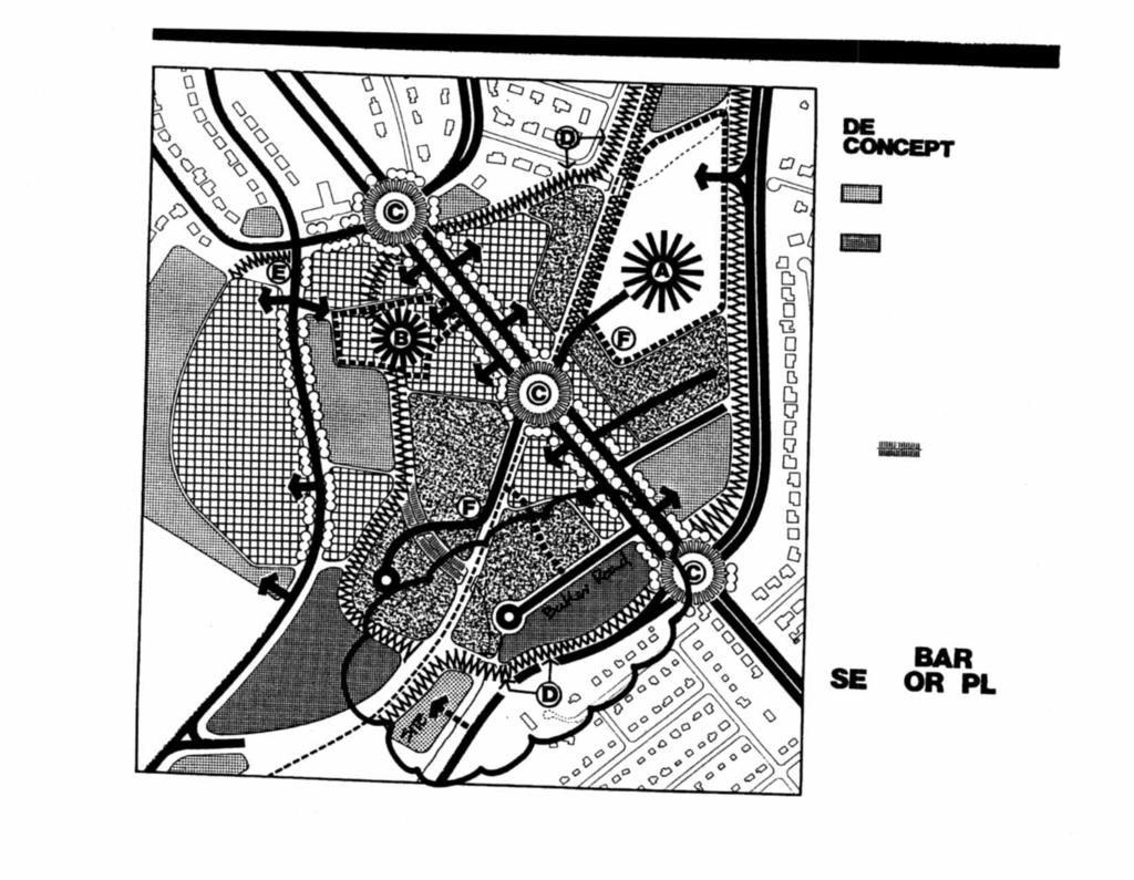
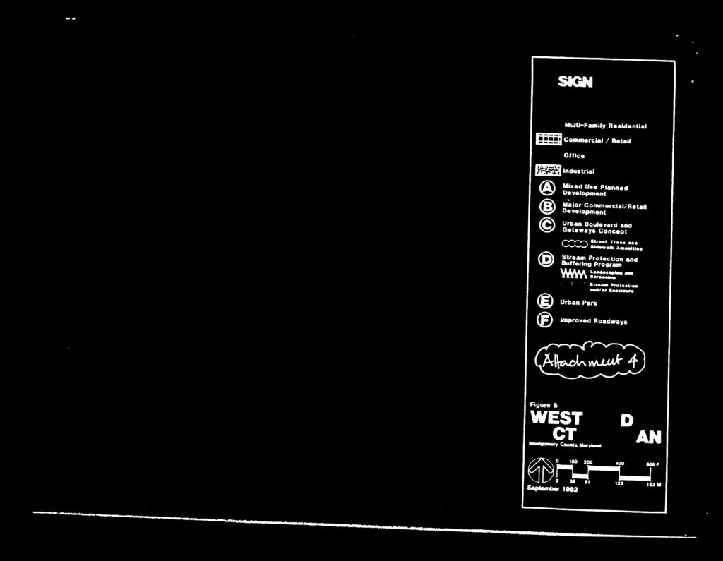
52
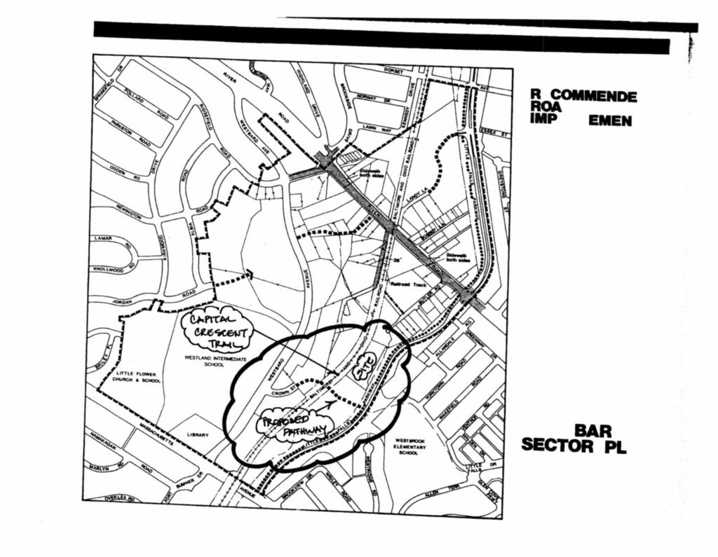
53
54
55
56
57
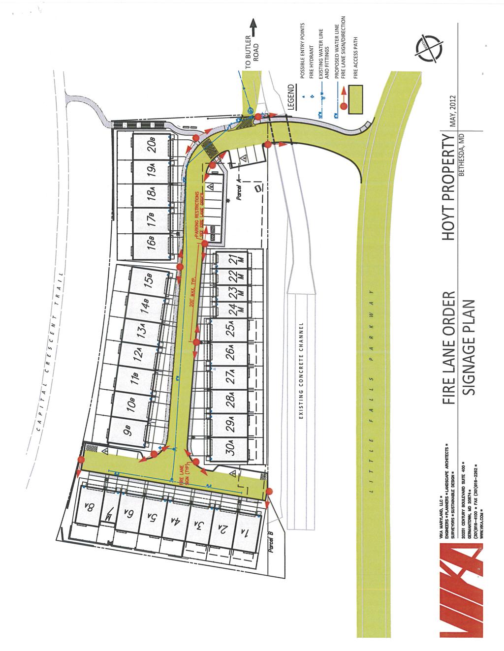
58
MONTGOMERY COUNTY PLANNING DEPARTMENT THE MARYLAND-NATIONAL CAPITAL PARK AND PLANNING COMMISSION
 MONTGOMERY COUNTY PLANNING DEPARTMENT THE MARYLAND-NATIONAL CAPITAL PARK AND PLANNING COMMISSION MCPB Item No. 8 Date: 03-07-13 Sonoma, Preliminary Plan, 120130040 Melissa Williams, Senior Planner, Melissa.williams@montgomeryplanning.org,
MONTGOMERY COUNTY PLANNING DEPARTMENT THE MARYLAND-NATIONAL CAPITAL PARK AND PLANNING COMMISSION
 MONTGOMERY COUNTY PLANNING DEPARTMENT THE MARYLAND-NATIONAL CAPITAL PARK AND PLANNING COMMISSION MCPB Item No. Date: 12/6/12 Limited Site Plan Amendment, 82000018D, DANAC Stiles Property, Lot 6 of Block
MONTGOMERY COUNTY PLANNING DEPARTMENT THE MARYLAND-NATIONAL CAPITAL PARK AND PLANNING COMMISSION
 MONTGOMERY COUNTY PLANNING DEPARTMENT THE MARYLAND-NATIONAL CAPITAL PARK AND PLANNING COMMISSION MCPB Item No. Hearing Date: 10/8/15 Howard Hughes Medical Institute, Limited Amendment of the Preliminary
MONTGOMERY COUNTY PLANNING DEPARTMENT THE MARYLAND-NATIONAL CAPITAL PARK AND PLANNING COMMISSION
 MONTGOMERY COUNTY PLANNING DEPARTMENT THE MARYLAND-NATIONAL CAPITAL PARK AND PLANNING COMMISSION MCPB Item No. Date: 12/4/14 Preliminary Plan No. 120140200, Northwood Knolls Description Patrick Butler,
MONTGOMERY COUNTY PLANNING DEPARTMENT THE MARYLAND-NATIONAL CAPITAL PARK AND PLANNING COMMISSION
 MONTGOMERY COUNTY PLANNING DEPARTMENT THE MARYLAND-NATIONAL CAPITAL PARK AND PLANNING COMMISSION MCPB Item No. Date: 1-17-13 Preliminary Plan 120110180 - Parmjit & Saini Estates Katherine Holt, Senior
MONTGOMERY COUNTY PLANNING DEPARTMENT THE MARYLAND-NATIONAL CAPITAL PARK AND PLANNING COMMISSION
 MONTGOMERY COUNTY PLANNING DEPARTMENT THE MARYLAND-NATIONAL CAPITAL PARK AND PLANNING COMMISSION MCPB Item No.: Date: 06-21-12 The Plantations, Preliminary Plan -120090240 Benjamin Berbert, Senior Planner,
MONTGOMERY COUNTY PLANNING DEPARTMENT THE MARYLAND-NATIONAL CAPITAL PARK AND PLANNING COMMISSION
 MONTGOMERY COUNTY PLANNING DEPARTMENT THE MARYLAND-NATIONAL CAPITAL PARK AND PLANNING COMMISSION MCPB Item No. 3 Date: 01-31-13 Preliminary Plan 120090300, Boyds Highlands Calvin Nelson, Jr. Planner Coordinator,
MONTGOMERY COUNTY PLANNING BOARD
 MONTGOMERY COUNTYPLANNING BOARD T H E MARYLAND-NATIONAL CAPITAL PARK A N D P L A N N I N G C O M M I S S I O N MCPB NO. 10-100 Preliminary Plan No. 120100210 Date of Hearing: July 1, 2010 MONTGOMERY COUNTY
MONTGOMERY COUNTY PLANNING BOARD
 APR :7 20m MONTGOMERY COUNTY PLANNING BOARD THE MARYLAND-NATIONAL CAPITAL PARK AND PLANNING COMMISSION MCPB No. 10-172 Date of Hearing: December 9, 2010 MONTGOMERY COUNTY PLANNING BOARD RESOLUTION WHEREAS,
CREEKSIDE TOWNHOMES Chevy Chase, Maryland Site Plan No Preliminary Plan No
 +1 (301) 656 5901 info@nova-habitat.com CREEKSIDE TOWNHOMES Chevy Chase, Maryland Site Plan No. 820160050 Preliminary Plan No. 120160130 Application Statement of Justification October 28, 2015 Nova-Habitat,
GROSVENOR-STRATHMORE METRO STATION MANDATORY REFERRAL APPLICATION NORTH BETHESDA, MD
 GROSVENOR-STRATHMORE METRO STATION MANDATORY REFERRAL APPLICATION NORTH BETHESDA, MD Submission by: Fivesquares JDA at Grosvenor Metro, LLC On behalf of Washington Metropolitan Area Transit Authority 1
MONTGOMERY COUNTY PLANNING DEPARTMENT THE MARYLAND-NATIONAL CAPITAL PARK AND PLANNING COMMISSION
 MONTGOMERY COUNTY PLANNING DEPARTMENT THE MARYLAND-NATIONAL CAPITAL PARK AND PLANNING COMMISSION MCPB Item No. Date: 05-30-13 Pre-Preliminary Plan No. 720130040: Potomac Highlands Callum Murray, supervisor,
DANAC Stiles Property. Preliminary Plan A
 DANAC Stiles Property Preliminary Plan 11996112A Vicinity Located in the LSC North District of the GSSC Master Plan. Adjacent Uses North: Single-family attached townhouses, R-60 zone; East: Office building,
RECOMMENDATION: Approval subject to the following conditions:
 RECOMMENDATION: Approval subject to the following conditions: 1) Approval under this preliminary plan is limited to 2 lots for 2 dwelling units 2) The record plat must note that the preliminary plan is
PLANNED DEVELOPMENT DISTRICT STANDARDS. Cadence Site
 PLANNED DEVELOPMENT DISTRICT STANDARDS Cadence Site A Planned Development District 1. Statement of General Facts, Conditions and Objectives Property Size: Approximately 57.51 Acres York County Tax Map
JUSTIFICATION STATEMENT FOR PRELIMINARY PLAN NO Preliminary Plan Justification for Chevy Chase Lake
 I. INTRODUCTION JUSTIFICATION STATEMENT FOR PRELIMINARY PLAN NO. 120150130 Preliminary Plan Justification for Chevy Chase Lake Applicant, CC Associates LLC (the Applicant ), by its attorneys, Linowes and
O-I (Office-Institutional) and AG-1(Agricultural)
 and AG-1(Agricultural)") PROPERTY INFORMATION ADDRESS 3503 and 3505 Bethany Bend DISTRICT, LAND LOTS 2/1 973 and 974 OVERLAY DISTRICT State Route 9 PETITION NUMBERS EXISTING ZONING O-I (Office-Institutional) and AG-1(Agricultural)
PROPERTY INFORMATION ADDRESS 3503 and 3505 Bethany Bend DISTRICT, LAND LOTS 2/1 973 and 974 OVERLAY DISTRICT State Route 9 PETITION NUMBERS EXISTING ZONING O-I (Office-Institutional) and AG-1(Agricultural)
APPLICANT NAME SUBDIVISION NAME DEVELOPMENT NAME LOCATION. CITY COUNCIL DISTRICT Council District 4 PRESENT ZONING PROPOSED ZONING
 SUBDIVISION, PLANNED UNIT DEVELOPMENT, PLANNING APPROVAL, ZONING AMENDMENT, & SIDEWALK WAIVER REQUEST STAFF REPORT Date: February 17, 2010 APPLICANT NAME SUBDIVISION NAME DEVELOPMENT NAME LOCATION David
HERON LANDING SUBDIVISION
 HERON LANDING SUBDIVISION Engineering Comments: Per FEMA guidelines, any development greater than 5 acres in size or subdivision 50 lots in size, requires a flood study. Width of drainage easement to be
ZONING AMENDMENT, PLANNED UNIT DEVELOPMENT & SUBDIVISION STAFF REPORT Date: August 8, 2013
 ZONING AMENDMENT, PLANNED UNIT DEVELOPMENT & SUBDIVISION STAFF REPORT Date: August 8, 2013 NAME SUBDIVISION NAME PV-Magnolia, LLC Twelve Trees Subdivision LOCATION 2860, 2862 and 2866 Pleasant Valley Road
Open Space Model Ordinance
 Open Space Model Ordinance Section I. Background Open space development has numerous environmental and community benefits, including: 1) Reduces the impervious cover in a development. Impervious cover
SITE DEVELOPMENT PLAN REQUIREMENTS CHECKLIST
 SITE DEVELOPMENT PLAN REQUIREMENTS CHECKLIST Completed DRC Application for Review Required for Application Process DRC Processing Fee 1 Commercial $2,500.00 Fire Department Review Fee 150.00 Total $2,650.00
REPORT TO THE SHELBY COUNTY PLANNING COMMISSION From the Department of Development Services Planning Services. February 4, 2019
 REPORT TO THE SHELBY COUNTY PLANNING COMMISSION From the Department of Development Services Planning Services February 4, 2019 Case No. Request for Rezoning Approval From E-1 to E-2 SD This is a request
ZONING AMENDMENT & SUBDIVISION STAFF REPORT Date: November 3, 2016
 ZONING AMENDMENT & SUBDIVISION STAFF REPORT Date: November 3, 2016 APPLICANT NAME SUBDIVISION NAME David Shumer 5955 Airport Subdivision CITY COUNCIL DISTRICT District 6 5955 Airport Boulevard, 754 Linlen
Bowie Marketplace Residential Detailed Site Plan Statement of Justification January 13, 2017 Revised February 2, 1017
 Bowie Marketplace Residential Detailed Site Plan Statement of Justification January 13, 2017 Revised February 2, 1017 Submitted on behalf of: BE Bowie LLC 5410 Edson Lane, Suite 220 Rockville, MD 20852
MONTGOMERY COUNTY PLANNING DEPARTMENT THE MARYLAND-NATIONAL CAPITAL PARK AND PLANNING COMMISSION
 MONTGOMERY COUNTY PLANNING DEPARTMENT THE MARYLAND-NATIONAL CAPITAL PARK AND PLANNING COMMISSION MCPB Item No. 6 Date: 9-27-18 Seneca Farms, Preliminary Plan No. 120170240 Jonathan Casey, Senior Planner,
MONTGOMERY COUNTY PLANNING DEPARTMENT THE MARYLAND-NATIONAL CAPITAL PARK AND PLANNING COMMISSION
 MONTGOMERY COUNTY PLANNING DEPARTMENT THE MARYLAND-NATIONAL CAPITAL PARK AND PLANNING COMMISSION MCPB Item No.: 5 Date: 09/29/2016 Washington Episcopal Day School: Preliminary Plan 120150160, Site Plan
MONTGOMERY COUNTY PLANNING DEPARTMENT THE MARYLAND-NATIONAL CAPITAL PARK AND PLANNING COMMISSION
 MONTGOMERY COUNTY PLANNING DEPARTMENT THE MARYLAND-NATIONAL CAPITAL PARK AND PLANNING COMMISSION Wheaton Woods, Preliminary Plan No. 120160060 MCPB Item No. Date: 02-25-16 Lori Shirley, Planner Coordinator,
SUBDIVISION, PLANNED UNIT DEVELOPMENT, PLANNING APPROVAL, ZONING AMENDMENT, & SIDEWALK WAIVER REQUEST STAFF REPORT Date: February 17, 2010
 SUBDIVISION, PLANNED UNIT DEVELOPMENT, PLANNING APPROVAL, ZONING AMENDMENT, & SIDEWALK WAIVER REQUEST STAFF REPORT Date: February 17, 2010 APPLICANT NAME SUBDIVISION NAME DEVELOPMENT NAME LOCATION David
PLANNED UNIT DEVELOPMENT & SUBDIVISION STAFF REPORT Date: April 18, 2019
 PLANNED UNIT DEVELOPMENT & SUBDIVISION STAFF REPORT Date: April 18, 2019 DEVELOPMENT NAME SUBDIVISION NAME Springhill Village Subdivision Springhill Village Subdivision LOCATION 4350, 4354, 4356, 4358,
MONTGOMERY COUNTY PLANNING DEPARTMENT THE MARYLAND-NATIONAL CAPITAL PARK AND PLANNING COMMISSION
 MONTGOMERY COUNTY PLANNING DEPARTMENT THE MARYLAND-NATIONAL CAPITAL PARK AND PLANNING COMMISSION MCPB Item No. 3 Date: 05/28/15 Ingleside, Preliminary Plan No. 120140140 Ryan Sigworth AICP, Senior Planner
MONTGOMERY COUNTY PLANNING DEPARTMENT THE MARYLAND-NATIONAL CAPITAL PARK AND PLANNING COMMISSION
 MONTGOMERY COUNTY PLANNING DEPARTMENT THE MARYLAND-NATIONAL CAPITAL PARK AND PLANNING COMMISSION MCPB Item Date: 06/01/17 900 Thayer Avenue: Project Plan Amendment No. 92005003B and Site Plan Amendment
Montgomery Village - South Valley Park: Subdivision Regulation Waiver SRW , and Site Plan No
 Montgomery Village - South Valley Park: Subdivision Regulation Waiver SRW - 201402, and Site Plan No. 820140070 12 SUBDIVISION REGULATION WAIVER RECOMMENDATION AND CONDITIONS OF APPROVAL Staff recommends
Staff Report: Date: Applicant: Property Identification: Acreage of Request: Current Zoning of Requested Area: Requested Action: Attached:
 Staff Report: Completed by Jeff Palmer Director of Planning & Zoning Date: November 7, 2018, Updated November 20, 2018 Applicant: Greg Smith, Oberer Land Developer agent for Ronald Montgomery ET AL Property
Cover Letter with Narrative Statement
 Cover Letter with Narrative Statement March 31, 2017 rev July 27, 2017 RE: Rushton Pointe Residential Planned Unit Development Application for Public Hearing for RPUD Rezone PL2015 000 0306 Mr. Eric Johnson,
ARTICLE 23 CONDOMINIUM STANDARDS
 ARTICLE 23 CONDOMINIUM STANDARDS Section 23.01 Intent. The intent of this Article is to provide regulatory standards for condominiums and site condominiums similar to those required for projects developed
Article 7: Residential Land Use and Development Requirements
 Article 7: Residential Land Use and Section 701: Statement of Intent (A) (B) (C) The intent of Article 7 is to develop certain land use and development requirements for the residential uses within Cumru
CHAPTER 6 CHESAPEAKE BAY PRESERVATION AREAS AND STREAM PROTECTION AREAS
 CHAPTER 6 CHESAPEAKE BAY PRESERVATION AREAS AND STREAM PROTECTION AREAS 6.1 INTRODUCTION Virginia s Chesapeake Bay Preservation Area (CBPA) Designation and Management Regulations (9VAC10-20 et seq.) require
Chapter Planned Residential Development Overlay
 Chapter 19.29 Planned Residential Development Overlay Sections 010 Purpose 020 Scope 030 Definitions 030 Minimum Size 040 Allowable Uses 050 Minimum Development Standards 060 Density Bonus 070 Open Space
MONTGOMERY COUNTY PLANNING DEPARTMENT
 MONTGOMERY COUNTY PLANNING DEPARTMENT THE MARYLAND-NATIONAL CAPITAL PARK AND PLANNING COMMISSION MCPB Item No. Date: 6/2/208 Washington Science Center-6000 Executive Boulevard, Limited Major Site Plan
SPECIAL ZONING DISTRICTS
 SPECIAL ZONING DISTRICTS 5.01 5.99 RESERVED 5.100 PLANNED DEVELOPMENTS: Purpose: This district is intended to accommodate unified design of residential, commercial, office, professional services, retail
CITRUS HEIGHTS COMMUNITY SPECIAL PLANNING AREA
 CITRUS HEIGHTS COMMUNITY SPECIAL PLANNING AREA 501-90. INTENT. It is the intent of the Board of Supervisors in adopting this Special Planning Area Ordinance to allow development on the property described
MONTGOMERY COUNTY PLANNING DEPARTMENT THE MARYLAND-NATIONAL CAPITAL PARK AND PLANNING COMMISSION
 MONTGOMERY COUNTY PLANNING DEPARTMENT THE MARYLAND-NATIONAL CAPITAL PARK AND PLANNING COMMISSION MCPB Item No. Date: 10-03-13 Preliminary Plan Amendment No. 11999034B Alvermar Woods, Lot 17 (In Response
Community Development
 Land Use Petition RZ-16-002 Date of Staff Recommendation Preparation: April 15, 2016 (CEL) Date of Planning Commission Recommendation: May 3, 2016 PROJECT LOCATION: DISTRICT/SECTION/LANDLOT(S): ACREAGE
Appendix J - Planned Unit Development (PUD)
") Appendix J - Planned Unit Development (PUD) Intent and Purpose The purpose of the PUD is: 1. To provide development that is consistent with the Comprehensive Land Use Plan and promote the goals and objectives
Appendix J - Planned Unit Development (PUD) Intent and Purpose The purpose of the PUD is: 1. To provide development that is consistent with the Comprehensive Land Use Plan and promote the goals and objectives
Financial Impact Statement There are no immediate financial impacts associated with the adoption of this report.
 STAFF REPORT Planning and Development Department Subject: Application by RYC Property to rezone a portion of lands on John Murray Dr. and Megan Lynn Dr. from R2 to R3 and to enter into a Development Agreement
ZONING AMENDMENT, PLANNED UNIT DEVELOPMENT & SUBDIVISION STAFF REPORT Date: September 15, 2011
 ZONING AMENDMENT, PLANNED UNIT DEVELOPMENT & SUBDIVISION STAFF REPORT Date: September 15, 2011 NAME SUBDIVISION NAME LOCATION Stratford, L.L.C. Grelot Office Park Subdivision North side of Grelot Road,
GWINNETT COUNTY CSO CONSERVATION SUBDIVISION OVERLAY DISTRICT REQUIREMENTS
 GWINNETT COUNTY CSO CONSERVATION SUBDIVISION OVERLAY DISTRICT REQUIREMENTS Section 1316. CSO Conservation Subdivision Overlay District. 1. Purposes. The purposes of this overlay district are as follows:
DEVELOPMENT DEPARTMENT STAFF REPORT THE PARK AT 5 TH
 DEVELOPMENT DEPARTMENT STAFF REPORT ARB Meeting Date: July 3, 2018 Item #: _PZ2018-293_ THE PARK AT 5 TH Request: Site Address: Project Name: Parcel Number: Applicant: Proposed Development: Current Zoning:
PLANNED UNIT DEVELOPMENTS (Ordinance No.: 3036, 12/3/07; Repealed & Replaced by Ordinance No.: 4166, 10/15/12)
") 159.62 PLANNED UNIT DEVELOPMENTS (Ordinance No.: 3036, 12/3/07; Repealed & Replaced by Ordinance No.: 4166, 10/15/12) A. PURPOSE 1. General. The Planned Unit Development (PUD) approach provides the flexibility
159.62 PLANNED UNIT DEVELOPMENTS (Ordinance No.: 3036, 12/3/07; Repealed & Replaced by Ordinance No.: 4166, 10/15/12) A. PURPOSE 1. General. The Planned Unit Development (PUD) approach provides the flexibility
ARTICLE FIVE FINAL DRAFT
 ARTICLE FIVE 021218 FINAL DRAFT Sec. 503.6 Open Space Preservation Option Open Space Preservation Option Open Space Preservation developments may be approved in the AR, R-1, R-2 and R-3 zoning districts,
TOWN OF ORO VALLEY PLANNING & ZONING COMMISSION MEETING DATE: December 6, 2011
 PLANNING & ZONING COMMISSION MEETING DATE: December 6, 2011 TO: FROM: SUBJECT: PLANNING & ZONING COMMISSION Matt Michels, Senior Planner mmichels@orovalleyaz.gov; tel. 229-4822 Public Hearing: Rancho de
Section 1: US 19 Overlay District
 Section 1: US 19 Overlay District Section 1.1 Intent and Purpose The purpose of the US Highway 19 Overlay District is to manage access to land development along US Highway 19 in a manner that preserves
Staff Report for Council Public Meeting
 Agenda Item 3.3 Staff Report for Council Public Meeting Date of Meeting: September 27, 2017 Report Number: SRPRS.17.134 Department: Division: Subject: Planning and Regulatory Services Development Planning
ARTICLE 14 PLANNED UNIT DEVELOPMENT (PUD) DISTRICT
 DISTRICT") ARTICLE 14 PLANNED UNIT DEVELOPMENT (PUD) DISTRICT Section 14.01 Intent. It is the intent of this Article to allow the use of the planned unit development (PUD) process, as authorized by the Michigan Zoning
ARTICLE 14 PLANNED UNIT DEVELOPMENT (PUD) DISTRICT Section 14.01 Intent. It is the intent of this Article to allow the use of the planned unit development (PUD) process, as authorized by the Michigan Zoning
PLANNED UNIT DEVELOPMENT & SUBDIVISION STAFF REPORT Date: November 17, 2016
 PLANNED UNIT DEVELOPMENT & SUBDIVISION STAFF REPORT Date: November 17, 2016 DEVELOPMENT NAME SUBDIVISION NAME LOCATION Autonation Ford of Mobile Autonation Ford of Mobile Subdivision 901, 909, and 925
SUBDIVISION, PLANNED UNIT DEVELOPMENT, ZONING AMENDMENT, & SIDEWALK WAIVER STAFF REPORT Date: July 19, 2018
 SUBDIVISION, PLANNED UNIT DEVELOPMENT, ZONING AMENDMENT, & SIDEWALK WAIVER STAFF REPORT Date: July 19, 2018 NAME SUBDIVISION NAME LOCATION West Mobile Properties, LLC U.S. Machine Subdivision 556, 566,
CHARLES CITY COUNTY SITE PLAN ORDINANCE. This Ordinance shall be known as the Charles City County Site Plan Ordinance.
 CHARLES CITY COUNTY SITE PLAN ORDINANCE Section 1. Title This Ordinance shall be known as the Charles City County Site Plan Ordinance. Section 2. Authority. This Ordinance is enacted pursuant to the authority
Request Conditional Rezoning (R-7.5 Residential to Conditional A-18 Apartment) Staff Recommendation Approval. Staff Planner Jimmy McNamara
 Staff Recommendation Approval. Staff Planner Jimmy McNamara") Applicants Property Owners Baker Villas, LLC; Ocean Rental Properties, LLC; James Edward Sollner; & Linda Susan Sollner Public Hearing November 8, 2017 City Council Election District Kempsville Agenda
Applicants Property Owners Baker Villas, LLC; Ocean Rental Properties, LLC; James Edward Sollner; & Linda Susan Sollner Public Hearing November 8, 2017 City Council Election District Kempsville Agenda
Staff Report PLANNED DEVELOPMENT. Salt Lake City Planning Commission. From: Lauren Parisi, Associate Planner; Date: December 14, 2016
 Staff Report PLANNING DIVISION COMMUNITY & NEIGHBORHOODS To: Salt Lake City Planning Commission From: Lauren Parisi, Associate Planner; 801-535-7932 Date: December 14, 2016 Re: 1611 South 1600 East PLANNED
FREQUENTLY USED PLANNING & ZONING TERMS
 City Of Mustang FREQUENTLY USED PLANNING & ZONING TERMS Abut: Having property lines, street lines, or zoning district lines in common. Accessory Structure: A structure of secondary importance or function
WESTMINSTER PARK SUBDIVISION
 WESTMINSTER PARK SUBDIVISION Engineering Comments: FINAL PLAT COMMENTS (should be addressed prior to submitting the FINAL PLAT for review and/or signature by the City Engineer): A. Provide all of the required
CITY OF FERNDALE HEARING EXAMINER
 CITY OF FERNDALE HEARING EXAMINER RE: Planned Unit Development ) 16001-PUD Preliminary Plat ) 16018-SE Plat Variance ) 16002-VAR Application by ) ) MD General, L.L.C. ) FINDINGS OF FACT, Malloy Heights
M-43 CORRIDOR OVERLAY ZONE
 ARTICLE 26.00 M-43 CORRIDOR OVERLAY ZONE Section 26.01 Findings A primary function of the M-43 state highway is to move traffic through the Township and to points beyond. As the primary east-west arterial
PLANNING COMMISSION STAFF REPORT. Merrimac PLNSUB Planned Development 38 West Merrimac November 9, Request. Staff Recommendation
 PLANNING COMMISSION STAFF REPORT Merrimac PLNSUB2011-00374 Planned Development 38 West Merrimac November 9, 2011 Planning and Zoning Division Department of Community and Economic Development Applicant:
MONTGOMERY COUNTY PLANNING DEPARTMENT THE MARYLAND-NATIONAL CAPITAL PARK AND PLANNING COMMISSION
 MONTGOMERY COUNTY PLANNING DEPARTMENT THE MARYLAND-NATIONAL CAPITAL PARK AND PLANNING COMMISSION MCPB Item No. 4 Date: July 24, 2017 Claiborne: Preliminary Plan No. 120170250 and Site Plan No. 820170080
For Vintages of Four Mile Creek Town of Niagara on the Lake, Ontario
 Planning Impact Analysis For Vintages of Four Mile Creek Town of Niagara on the Lake, Ontario Prepared by: Upper Canada Consultants 261 Martindale Road Unit #1 St. Catharines, Ontario L2W 1A1 Prepared
WHEREAS, the staff of The Maryland-National Capital Park and Planning Commission recommended APPROVAL of the application with conditions; and
 R E S O L U T I O N WHEREAS, Redeemed Christian Church of God is the owner of a 2.83-acre parcel of land known as Lot 9, Lot 19, P/O Lot 1 and P/O Lot 18, Block B, Plat Book A, Plat 5, said property being
PLANNING COMMISSION REPORT Regular Agenda -Public Hearing Item
 PDP-13-00518 Item No. 3B- 1 PLANNING COMMISSION REPORT Regular Agenda -Public Hearing Item PC Staff Report 2/24/14 ITEM NO. 3B PRELIMINARY DEVELOPMENT PLAN FOR HERE @ KANSAS; 1101 INDIANA ST (SLD) PDP-13-00518:
PLANNED UNIT DEVELOPMENT & SUBDIVISION STAFF REPORT August 18, 2016
 PLANNED UNIT DEVELOPMENT & SUBDIVISION STAFF REPORT August 18, 2016 DEVELOPMENT NAME SUBDIVISION NAME Mullinax Ford Subdivision Mullinax Ford Subdivision LOCATION CITY COUNCIL DISTRICT District 6 Southeast
Article Floating Zone Requirements
 Division 5.1. In General Article 59-5. Floating Zone Requirements Section 5.1.1. Zone Categories There are 4 categories of Floating zones: A. Residential Floating zones (Division 5.2); B. Commercial/Residential
CITY PLAN COMMISSION STAFF REPORT
 CITY PLAN COMMISSION STAFF REPORT SUBJECT: Request for a Change of Zoning and Preliminary Development Plan FROM: Mara Perry, Director of Planning & Development MEETING DATE: November 6, 2017 PETITION:
ARTICLE XI CONDITIONAL USE PERMITS
 ARTICLE XI CONDITIONAL USE PERMITS 11.1 Purpose. The City of Hailey recognizes that certain uses possess unique and special characteristics with respect to their location, design, size, method of operation,
WESTMINSTER PARK PLACE SUBDIVISION
 WESTMINSTER PARK PLACE SUBDIVISION Engineering Comments: FINAL PLAT COMMENTS (should be addressed prior to submitting the FINAL PLAT for review and/or signature by the City Engineer): A. Provide all of
FINAL DRAFT 10/23/06 ARTICLE VI
 FINAL DRAFT 10/23/06 ARTICLE VI 185-41.1. Planned Residential Development A. Purpose and Intent. The purposes of the Planned Residential Development (PRD) bylaw are to maintain the rural character of Dover,
7-l MoNtcoupnv CouNtv PreNNrNc Boeno,I 'tne ITaRYLAND-NATIoNAL CAPITAL PARI< AND PLANNING con{n{ission
 7-l MoNtcoupnv CouNtv PreNNrNc Boeno,I 'tne ITaRYLAND-NATIoNAL CAPITAL PARI< AND PLANNING con{n{ission MCPB No. 16-023 Preliminary Plan No. '120160110 Date of Hearing: March 3, 2016 ltar 17 frft, RESOLUTlON
In order to permit maximum applicability of the PUD District, PUD-1 and PUD-2 Districts are hereby created.
 ARTICLE III. PUD ned Unit Development Overlay District 205-128. Purpose. The PUD ned Unit Development Overlay District is intended to provide flexibility in the design of planned projects; to encourage
Staff Report: Date: Applicant: Property Identification: Acreage of Request: Current Zoning of Requested Area: Requested Action: Attached:
 Staff Report: Completed by Jeff Palmer Director of Planning & Zoning Date: November 7, 2018 Applicant: Greg Smith, Oberer Land Developer agent for Ronald Montgomery ET AL Property Identification: Frontage
Community Development
 Land Use Petition RZ-15-010 Concurrent Variance VC-15-010-01 Date of Staff Recommendation Preparation: August 14, 2015 Date of Planning Commission Recommendation: September 1, 2015 PROJECT LOCATION: DISTRICT/SECTION/LANDLOT(S):
Residential Major Subdivision Review Checklist
 Residential Major Subdivision Review Checklist Plan Submittal Requirements: 2 full sets of stamped plans Electric submittal - all plans contained in a single PDF 3 full sets if commercial kitchen or dining
R E S O L U T I O N. a. Remove Table B from the plan.
 R E S O L U T I O N WHEREAS, Werrlein Property is the owner of a 0.3902-acre parcel of land in the 5th Election District of Prince George s County, Maryland, being zoned One-Family Detached Residential
EXHIBIT D. Planned Unit Development Written Description April 13, 2016 Rouen Cove Phase II PUD
 1 EXHIBIT D Planned Unit Development Written Description April 13, 2016 Rouen Cove Phase II PUD Development # 8986.001 Developer: Curtis L. Hart Hart Resources LLC 8051 Tara Lane Jacksonville, Florida
(a) Commercial uses on Laurel Avenue, abutting the TRO District to the
 Commercial uses on Laurel Avenue, abutting the TRO District to the") 32X Zoning Code 150.36 TRANSITIONAL RESIDENTIAL OVERLAY DISTRICT. (A) Intent and purpose. (1) It is the intent of the Transitional Residential Overlay District (hereinafter referred to as the "TRO District")
32X Zoning Code 150.36 TRANSITIONAL RESIDENTIAL OVERLAY DISTRICT. (A) Intent and purpose. (1) It is the intent of the Transitional Residential Overlay District (hereinafter referred to as the "TRO District")
1.94 acres. Gwinnett Prado, L.P. c/o Brogdon Consulting Duluth, GA Contact: Ted Sandler
 Land Use Petition RZ-15-006 Date of Staff Recommendation Preparation: April 21, 2015 Revised to Incorporate Planning Commission Recommendations: 5/6/15 PROJECT LOCATION: 10800 Block of State Bridge Road
City of Midland Application for Site Plan Review
 City of Midland Application for Site Plan Review Submission Date: Property Owner: Mailing Address: Phone number: ( ) Cell phone: ( ) Email address: Fax: ( ) Owner s Signature: Applicant Name (if not owner):
Condominium Unit Requirements.
 ARTICLE 19 CONDOMINIUM REGULATIONS Section 19.01 Purpose. The purpose of this Article is to regulate projects that divide real property under a contractual arrangement known as a condominium. New and conversion
MONTGOMERY COUNTY PLANNING DEPARTMENT THE MARYLAND-NATIONAL CAPITAL PARK AND PLANNING COMMISSION
 MONTGOMERY COUNTY PLANNING DEPARTMENT THE MARYLAND-NATIONAL CAPITAL PARK AND PLANNING COMMISSION MCPB Item No. Date: 7-16-15 Travilah Grove, Preliminary Plan Amendment 12012029A, and Site Plan Amendment
4. facilitate the construction of streets, utilities and public services in a more economical and efficient manner;
 PVPC MODEL BYLAW BY-RIGHT CLUSTER ZONING BYLAW Prepared by Pioneer Valley Planning Commission Revised: October 2001 1.00 Development 1.01 Development Allowed By Right Development in accordance with this
MONTGOMERY COUNTY PLANNING DEPARTMENT THE MARYLAND-NATIONAL CAPITAL PARK AND PLANNING COMMISSION
 MONTGOMERY COUNTY PLANNING DEPARTMENT THE MARYLAND-NATIONAL CAPITAL PARK AND PLANNING COMMISSION MCPB Item No.: Date: 11-12-15 15931 Frederick Road (CarMax) Annexation Request ANX2015-00145 Patrick Butler,
E L M E R B O R O U G H L A N D U S E B O A R D APPLICATION COVER SHEET (to be completed for all applications and appeals)
") E L M E R B O R O U G H L A N D U S E B O A R D APPLICATION COVER SHEET (to be completed for all applications and appeals) 1. Name(s): 2. Address: 3. Telephone Number(s): 4. E-mail: 5. Owner Name(s) (if
E L M E R B O R O U G H L A N D U S E B O A R D APPLICATION COVER SHEET (to be completed for all applications and appeals) 1. Name(s): 2. Address: 3. Telephone Number(s): 4. E-mail: 5. Owner Name(s) (if
MONTGOMERY COUNTY PLANNING DEPARTMENT THE MARYLAND-NATIONAL CAPITAL PARK AND PLANNING COMMISSION
 MONTGOMERY COUNTY PLANNING DEPARTMENT THE MARYLAND-NATIONAL CAPITAL PARK AND PLANNING COMMISSION MCPB Item No.: 4 Date: 2-7-19 Old Angler s Cove, Preliminary Plan No. 120170290 Ryan Sigworth AICP, Senior
ARTICLE VII. NONCONFORMITIES. Section 700. Purpose.
 ARTICLE VII. NONCONFORMITIES. Section 700. Purpose. The purpose of this chapter is to regulate and limit the development and continued existence of legal uses, structures, lots, and signs established either
PLANNING AND ZONING COMMISSION AGENDA MEMORANDUM
 City and County of Broomfield, Colorado PLANNING AND ZONING COMMISSION AGENDA MEMORANDUM To: Planning and Zoning Commission From: John Hilgers, Planning Director Anna Bertanzetti, Principal Planner Meeting
9. REZONING NO Vicinity of the northwest corner of 143 rd Street and Metcalf Avenue
 9. REZONING NO. 2002-15 Vicinity of the northwest corner of 143 rd Street and Metcalf Avenue 1. APPLICANT: Andrew Schlagel is the applicant for this request. 2. REQUESTED ACTION: The applicant is requesting
1105 SUBDIVISIONS, PARTITIONS, REPLATS, CONDOMINIUM PLATS, AND VACATIONS OF RECORDED PLATS
 1105 SUBDIVISIONS, PARTITIONS, REPLATS, CONDOMINIUM PLATS, AND VACATIONS OF RECORDED PLATS 1105.01 PURPOSE AND APPLICABILITY Section 1105 is adopted to provide standards, criteria, and procedures under
MONTGOMERY COUNTY PLANNING DEPARTMENT THE MARYLAND-NATIONAL CAPITAL PARK AND PLANNING COMMISSION
 MONTGOMERY COUNTY PLANNING DEPARTMENT THE MARYLAND-NATIONAL CAPITAL PARK AND PLANNING COMMISSION Ganassa Property, Preliminary Plan, 120040640 MCPB Item No. Date: 7-25-13 Callum Murray, Area 3 Supervisor,
Article Optional Method Requirements
 Article 59-6. Optional Method Requirements [DIV. 6.1. MPDU DEVELOPMENT IN RURAL RESIDENTIAL AND RESIDENTIAL ZONES Sec. 6.1.1. General Requirements... 6 2 Sec. 6.1.2. General Site and Building Type Mix...
TOTTENHAM SECONDARY PLAN
 TOTTENHAM SECONDARY PLAN AMENDMENT NO. 11 TO THE OFFICIAL PLAN OF THE TOWN OF NEW TECUMSETH The following text and schedules to the Official Plan of the Town of New Tecumseth constitute Amendment No. 11
1 September 9, 2015 Public Hearing
 1 September 9, 2015 Public Hearing APPLICANT & PROPERTY OWNER: HOLLOMON- BROWN FUNERAL HOME, INC. STAFF PLANNER: Carolyn A.K. Smith REQUEST: Change of Zoning (R-5D Residential District to Conditional O-2
Napa County Planning Commission Board Agenda Letter
 Agenda Date: 9/20/2017 Agenda Placement: 8C Napa County Planning Commission Board Agenda Letter TO: FROM: Napa County Planning Commission Charlene Gallina for David Morrison - Director Planning, Building