City of Tarpon Springs, Florida STAFF REPORT
|
|
|
- Quentin Williams
- 5 years ago
- Views:
Transcription
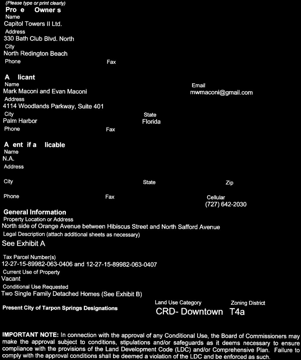
1 City of Tarpon Springs, Florida STAFF REPORT July 17, 2018 TO: FROM: PLANNING AND ZONING BOARD MAYOR AND BOARD OF COMMISSIONERS PLANNING AND ZONING DEPARTMENT HEARING DATES: JULY 16, 2018 (PLANNING & ZONING BOARD) JULY 24, 2018 (BOARD OF COMMISSIONERS) SUBJECT: APP-18-57: MARK MACONI AND EVAN MACONI RESOLUTION : A RESOLUTION OF THE CITY OF TARPON SPRINGS, FLORIDA, APPROVING APPLICATION #18-57 REQUESTING A CONDITIONAL USE PERMIT TO ALLOW CONSTRUCTION OF TWO SINGLE FAMILY RESIDENCES, ONE ON EACH OF TWO LOTS DESCRIBED AS FOLLOWS: EASTERLY PORTION OF LOT 4, BLOCK 63 OF TARPON SPRINGS OFFICIAL MAP, AND, WESTERLY PORTION OF LOT 4, BLOCK 63 OF TARPON SPRINGS OFFICIAL MAP, LOCATED ON THE NORTH SIDE OF EAST ORANGE STREET BETWEEN HIBISCUS STREET AND NORTH SAFFORD AVENUE, IN THE T4A DISTRICT OF THE SPECIAL AREA PLAN; PROVIDING FOR FINDINGS; PROVIDING FOR CONDITIONS; AND PROVIDING FOR AN EFFECTIVE DATE. I. APPLICATION A. Request: Conditional Use approval to allow construction of two singlefamily residences in the T4a district of the Special Area Plan B. Applicant: Mark Maconi and Evan Maconi, 4114 Woodlands Parkway, Suite 401, Palm Harbor, FL C. Owner: Capitol Towers II, Ltd., 330 Bath Club Boulevard North, North Redington Beach, FL II. PROPERTY INFORMATION A. Location: Easterly portion of Lot 4, Block 63, Tarpon Springs Official Map, and, westerly portion of Lot 4, Block 63, Tarpon Springs Official Map, both 1
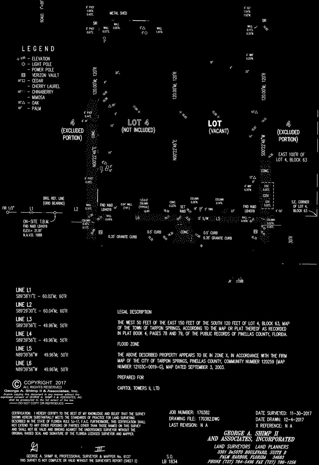
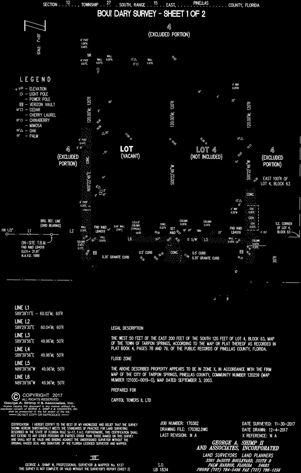
2 lots being located on the north side of East Orange Street between Hibiscus Street and North Safford Avenue. B. Subject Parcel Zoning/ Land Use Plan Designation: T4a (Residential High) / CRD (Community Redevelopment District) C. Surrounding Zoning and Existing Uses: Zoning Existing Use North: T4c Single-Family and Multi-Family Residential East: T4a Single Family Residential and Vacant South: T4a Commercial Parking Lot, Office West: T4a Institutional D. Tax Parcel ID Numbers: , and, III. BACKGROUND The applicant is seeking conditional use approval to construct two single family residences, one on each of two vacant lots located on the north side of East Orange Street, between Hibiscus Street and North Safford Avenue. The subject property is zoned T4a (Residential High) and is located in the Downtown Character District. Pursuant to Table 4F of the Transect-Based Infill Code for the Sponge Docks and Community Redevelopment Area the proposed land use is subject to conditional use review. To ensure compliance with the desired character of the T4a district, the proposed residence will be subject to the design standards of the district including standards regarding building placement, frontage type, height, building form, parking location, lot coverage, and setbacks. IV. STANDARDS FOR REVIEW Pursuant to Section , Standards for Review of Conditional Uses, of the Tarpon Springs Land Development Code (LDC), no conditional use shall be recommended for approval or receive a final action of approval unless a positive finding, based upon substantial competent evidence either presented at a public hearing held by the Board or reviewed personally by the Board members, is made on each of the following standards: 1. Conformance with the requirements of the Land Development Code. Analysis: The proposed use is subject to conditional use review in the T4a district. The proposed design of each of the two residences complies with the 2
3 setback and other performance standards of the T4a district. It is noted that the required side setbacks have been relaxed to accommodate driveway access onto East Orange Street since there is no rear alley available. The proposed driveway and garage configurations for these lots match the adjacent properties in that the parking itself is masked from street view, and the driveway width accommodates only one vehicle. The applicant has not submitted a landscaping plan, but has indicated that existing trees at the front of each site will be retained. A condition is proposed to require a final landscaping plan. 2. The use to which the property may be put is appropriate to the property in question and is compatible with existing and planned uses in the area. Analysis: The proposed use will be located adjacent to other like uses and will be built consistent with the performance standards of the T4a district. It is noted this block, that contains the subject lots, forms the border between the Downtown and Uptown Character Districts. There is a transition to more residential as one moves north from this block, and a transition to more commercial and mixed uses going south from this block. The built properties in the block itself illustrate this transition. They are all built with residential uses and only one institutional use, located on the southwest corner of the block. 3. The conditional use is consistent with the goals, objectives and policies of all Elements of the City Comprehensive Plan. Analysis: The conditional use is consistent with the goals, objectives, and policies of all elements of the City Comprehensive Plan. 4. The conditional use will not result in significant adverse impacts to the environment or historical resources. Analysis: The use is located within the City s National Register and Local Historic Districts. The use was reviewed and approved by the City s Heritage Preservation Board for compliance with historic district standards on January 8, 2018 (Application Numbers and ). The use is not proposed on an environmentally sensitive site. 5. The conditional use will not adversely affect adjoining property values. Analysis: The proposed single-family residences are located adjacent to other like uses in this block and will be built in accordance with the standards of the T4a district. These standards will help ensure that the proposed conditional use will fit in with the character of the neighborhood and will not adversely affect property values. 6. The conditional use will not adversely impact nor exceed the capacity or the fiscal ability of the City to provide available public facilities, including 3
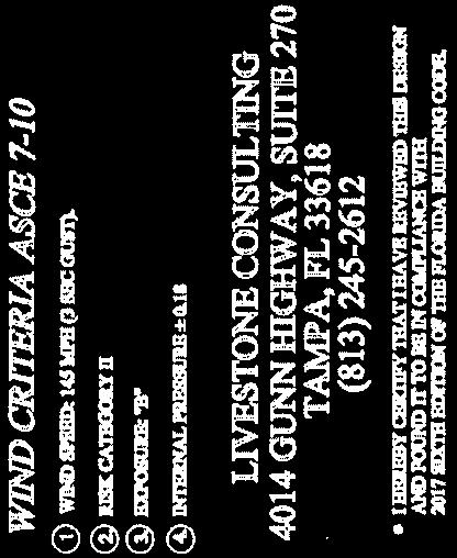
4 transportation, water and sewer, solid waste, drainage, recreation, education, fire protection, library service and other similar public facilities. Analysis: The single-family residences are proposed to be built on vacant residential lots located within the Community Redevelopment Area. The development will not require the extension of public services to the site, and will not adversely affect the ability of the City to provide adequate public facilities. 7. The conditional use shall provide for efficient and orderly development considering the impact upon growth patterns and the cost to the City to provide public facilities. Analysis: The proposed conditional use is located on two vacant lots that are within the Community Redevelopment Area. Based on the location and the very limited scale of the proposed project, the conditional use will promote efficient and orderly development within the City and will not adversely affect growth patterns and the ability of the City to provide public facilities. V. STAFF RECOMMENDATION Staff is recommending approval of Resolution with the following conditions: 1. The conditional use will expire within one year of approval, if a building permit is not issued for the property. 2. A site plan submitted with the building permit application shall include a landscaping plan that demonstrates compliance with the T4a district requirements. VI. PLANNING AND ZONING BOARD RECOMMENDATION The Planning and Zoning Board heard this application on July 16, There was no public opposition or comment on this application. The Board voted unanimously to recommend approval of Resolution with one condition. List of Exhibits: 1) Vicinity Maps 2) Original Application 3) Property Cards 4) Property Surveys 5) Site Plan View 6) Elevation View 7) Lot Coverage Calculations 8) Resolution

5 Vicinity Map: App Subject Property 5

6 Aerial Map: App Subject Property 6

7


8
9
10
11
12
13
14
15

 Total Living: SF: Total Gross SF: [click here to hide] Legal Description")
 Mortgage Letter File for Homestead Exemption 2018 Parcel Use Exemption 2018 2019 Homestead: No No Government: No No Institutional: No No Historic: No No")
 Most Recent Recording Sales Comparison Census Tract Evacuation Zone Plat")
")


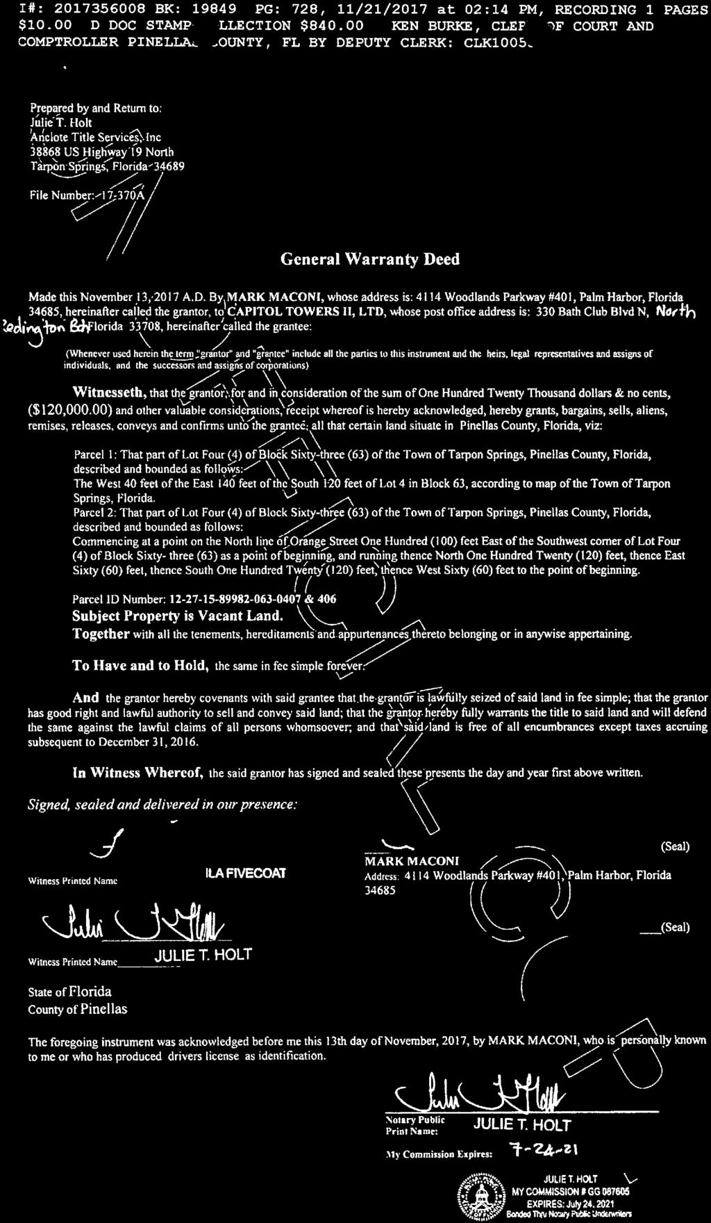
 See all transactions Sale Date Book/Page Price Q/U V/I 13 Nov 2017 19849 / 0728 $120,000 M V 11 May 2017 19633 / 0726 $50,000 M V 11 May 2017 19633 / 0725 $50,000 M V 2017 Land")

16 Property Appraiser General Information Interactive Map of this parcel Back to Query Results New Search Tax Collector Home Page Contact Us WM Compact Property Record Card Tax Estimator Updated July 5, Print Radius Search Ownership/Mailing Address Change Mailing Address CAPITOL TOWERS II LTD 330 BATH CLUB BLVD N NORTH REDINGTON BEACH FL Site Address ORANGE ST TARPON SPRINGS Property Use: 0000 (Vacant Residential - lot & acreage less than 5 acres) Total Living: SF: Total Gross SF: [click here to hide] Legal Description TARPON SPRINGS OFFICIAL MAP BLK 63, THAT PART OF LOT 4 DESC COM SE COR OF SD LOT 4 TH W'LY 100FT FOR POB TH N00D22'46"E 120FT TH N89D39'56"W 50FT TH S00D22'46"W 120FT TH S89D39'56"E 50FT TO POB (SEE S ) Mortgage Letter File for Homestead Exemption 2018 Parcel Use Exemption Homestead: No No Government: No No Institutional: No No Historic: No No Homestead Use Percentage: 0.00% Non-Homestead Use Percentage: % Classified Agricultural: No Parcel Information Latest Notice of Proposed Property Taxes (TRIM Notice) Most Recent Recording Sales Comparison Census Tract Evacuation Zone Plat Book/Page (NOT the same as a FEMA Flood Zone) 19849/0728 $37, C D-G/ Final Value Information Year Just/Market Value Assessed Value / Non-HX Cap County Taxable Value School Taxable Value Municipal Taxable Value 2017 $29,178 $14,554 $14,554 $29,178 $14,554 [click here to hide] Value History as Certified (yellow indicates correction on file) Year Homestead Exemption Just/Market Value Assessed Value County Taxable Value School Taxable Value Municipal Taxable Value 2017 No $29,178 $14,554 $14,554 $29,178 $14, No $30,050 $13,231 $13,231 $30,050 $13, No $12,028 $12,028 $12,028 $12,028 $12, No $15,219 $15,219 $15,219 $15,219 $15, No $26,259 $18,455 $18,455 $26,259 $18, No $20,566 $16,777 $16,777 $20,566 $16, No $26,203 $15,252 $15,252 $26,203 $15, No $13,865 $13,865 $13,865 $13,865 $13, No $26,877 $26,877 $26,877 $26,877 $26, No $30,100 $30,100 $30,100 $30,100 $30, No $34,200 $34,200 $34,200 N/A $34, No $24,300 $24,300 $24,300 N/A $24, No $25,200 $25,200 $25,200 N/A $25, No $22,100 $22,100 $22,100 N/A $22, No $21,000 $21,000 $21,000 N/A $21, No $22,600 $22,600 $22,600 N/A $22, No $19,900 $19,900 $19,900 N/A $19, No $22,300 $22,300 $22,300 N/A $22, No $11,200 $11,200 $11,200 N/A $11, No $11,200 $11,200 $11,200 N/A $11, No $23,400 $23,400 $23,400 N/A $23, No $23,000 $23,000 $23,000 N/A $23, Tax Information 2017 Tax Bill Tax District: TS 2017 Final Millage Rate Do not rely on current taxes as an estimate following a change in ownership. A significant change in taxable value may occur after a transfer due to a loss of exemptions, reset of the Save Our Homes or 10% Cap, and/or market conditions. Please use our new Tax Estimator to estimate taxes under new ownership. Amendment 1 - Will you Benefit? Check Estimated 3rd Homestead Exemption Benefit Ranked Sales (What are Ranked Sales?) See all transactions Sale Date Book/Page Price Q/U V/I 13 Nov / 0728 $120,000 M V 11 May / 0726 $50,000 M V 11 May / 0725 $50,000 M V 2017 Land Information Seawall: No Frontage: None View: Land Use Land Size Unit Value Units Total Adjustments Adjusted Value Method Vacant (00) 50x $63,700 FF [click here to hide] 2018 Extra Features Description Value/Unit Units Total Value as New Depreciated Value Year No Extra Features on Record [click here to hide] Permit Data Permit information is received from the County and Cities. This data may be incomplete and may exclude permits that do not result in field reviews (for example for water heater replacement permits). We are required to list all improvements, which may include unpermitted construction. Any questions regarding permits, or the status of non-permitted improvements, should be directed to the permitting jurisdiction in which the structure is located. Permit Number Description Issue Date Estimated Value DEMOLITION 19 Nov 2003 $1,900 + Use of this PARCEL MAP is subject to terms of use at: 1 of 2 7/5/2018, 3:46 PM
17 Property Appraiser General Information 2 of 2 7/5/2018, 3:46 PM Interactive Map of this parcel Map Legend Back to Query Results New Search Tax Collector Home Page Contact Us
18 Property Appraiser General Information Interactive Map of this parcel Back to Query Results New Search Tax Collector Home Page Contact Us WM Compact Property Record Card Tax Estimator Updated July 5, Print Radius Search Ownership/Mailing Address Change Mailing Address CAPITOL TOWERS II LTD 330 BATH CLUB BLVD N NORTH REDINGTON BEACH FL Site Address ORANGE ST TARPON SPRINGS Property Use: 0000 (Vacant Residential - lot & acreage less than 5 acres) Total Living: SF: Total Gross SF: [click here to hide] Legal Description TARPON SPRINGS OFFICIAL MAP BLK 63, THAT PART OF LOT 4 DESC COM SE COR OF SD LOT 4 TH W'LY 140FT FOR POB TH N00D22'46"E 120FT TH N89D39'56"W 50FT TH S00D22'46"W 120FT TH S89D39'56"E 50FT TO POB (SEE S ) Mortgage Letter File for Homestead Exemption 2018 Parcel Use Exemption Homestead: No No Government: No No Institutional: No No Historic: No No Homestead Use Percentage: 0.00% Non-Homestead Use Percentage: % Classified Agricultural: No Parcel Information Latest Notice of Proposed Property Taxes (TRIM Notice) Most Recent Recording Sales Comparison Census Tract Evacuation Zone Plat Book/Page (NOT the same as a FEMA Flood Zone) 19849/0728 $56, D D-G/ Final Value Information Year Just/Market Value Assessed Value / Non-HX Cap County Taxable Value School Taxable Value Municipal Taxable Value 2017 $43,745 $21,806 $21,806 $43,745 $21,806 [click here to hide] Value History as Certified (yellow indicates correction on file) Year Homestead Exemption Just/Market Value Assessed Value County Taxable Value School Taxable Value Municipal Taxable Value 2017 No $43,745 $21,806 $21,806 $43,745 $21, No $45,032 $19,824 $19,824 $45,032 $19, No $18,022 $18,022 $18,022 $18,022 $18, No $21,435 $21,435 $21,435 $21,435 $21, No $39,131 $29,667 $29,667 $39,131 $29, No $29,444 $26,970 $26,970 $29,444 $26, No $36,239 $24,518 $24,518 $36,239 $24, No $22,289 $22,289 $22,289 $22,289 $22, No $39,848 $39,848 $39,848 $39,848 $39, No $46,300 $46,300 $46,300 $46,300 $46, No $51,000 $51,000 $51,000 N/A $51, No $41,500 $41,500 $41,500 N/A $41, No $42,500 $42,500 $42,500 N/A $42, No $33,000 $33,000 $33,000 N/A $33, No $55,900 $55,900 $55,900 N/A $55, No $31,900 $31,900 $31,900 N/A $31, No $40,200 $40,200 $40,200 N/A $40, No $36,300 $36,300 $36,300 N/A $36, No $24,300 $24,300 $24,300 N/A $24, No $41,900 $41,900 $41,900 N/A $41, No $40,700 $40,700 $40,700 N/A $40, No $39,200 $39,200 $39,200 N/A $39, Tax Information 2017 Tax Bill Tax District: TS 2017 Final Millage Rate Do not rely on current taxes as an estimate following a change in ownership. A significant change in taxable value may occur after a transfer due to a loss of exemptions, reset of the Save Our Homes or 10% Cap, and/or market conditions. Please use our new Tax Estimator to estimate taxes under new ownership. Amendment 1 - Will you Benefit? Check Estimated 3rd Homestead Exemption Benefit Ranked Sales (What are Ranked Sales?) See all transactions Sale Date Book/Page Price Q/U V/I 13 Nov / 0728 $120,000 M V 11 May / 0726 $50,000 M V 11 May / 0725 $50,000 M V 2017 Land Information Seawall: No Frontage: None View: Land Use Land Size Unit Value Units Total Adjustments Adjusted Value Method Vacant (00) 50x $63,700 FF [click here to hide] 2018 Extra Features Description Value/Unit Units Total Value as New Depreciated Value Year No Extra Features on Record [click here to hide] Permit Data Permit information is received from the County and Cities. This data may be incomplete and may exclude permits that do not result in field reviews (for example for water heater replacement permits). We are required to list all improvements, which may include unpermitted construction. Any questions regarding permits, or the status of non-permitted improvements, should be directed to the permitting jurisdiction in which the structure is located. Permit Number Description Issue Date Estimated Value DEMOLITION 19 Nov 2003 $2,000 + Use of this PARCEL MAP is subject to terms of use at: 1 of 2 7/5/2018, 3:47 PM
19 Property Appraiser General Information 2 of 2 7/5/2018, 3:47 PM Interactive Map of this parcel Map Legend Back to Query Results New Search Tax Collector Home Page Contact Us


20

21
22
23


24


25


26
27
28
29 RESOLUTION NO A RESOLUTION OF THE CITY OF TARPON SPRINGS, FLORIDA, APPROVING APPLICATION #18-57 REQUESTING A CONDITIONAL USE PERMIT TO ALLOW CONSTRUCTION OF TWO SINGLE FAMILY RESIDENCES, ONE ON EACH OF TWO LOTS DESCRIBED AS FOLLOWS: EASTERLY PORTION OF LOT 4, BLOCK 63 OF TARPON SPRINGS OFFICIAL MAP, AND, WESTERLY PORTION OF LOT 4, BLOCK 63 OF TARPON SPRINGS OFFICIAL MAP, LOCATED ON THE NORTH SIDE OF EAST ORANGE STREET BETWEEN HIBISCUS STREET AND NORTH SAFFORD AVENUE, IN THE T4A DISTRICT OF THE SPECIAL AREA PLAN; PROVIDING FOR FINDINGS; PROVIDING FOR CONDITIONS; AND PROVIDING FOR AN EFFECTIVE DATE. WHEREAS, the City of Tarpon Springs has received an application for a Conditional Use to allow construction of two single family residences on property located on the easterly portion and the westerly portion of Lot 4, Block 63, Tarpon Springs Official, on the north side of East Orange Street between North Pinellas Avenue and North Safford Avenue; and, WHEREAS, Table 4F of the Appendix B (Transect-Based Infill Code for the Sponge Docks and Community Redevelopment Area) of the Code of Ordinances requires conditional use approval for such uses; and, WHEREAS, the Planning and Zoning Board held a public hearing on this application at its meeting of July 16, 2018 and recommended approval; and, WHEREAS, the Board of Commissioners must approve, deny or approve subject to conditions each application for conditional use approval; and, WHEREAS, written notice and posted legal notice of this action has been provided in accordance with Article XII of the Comprehensive Zoning and Land Development Code. NOW, THEREFORE, BE IT RESOLVED BY THE BOARD OF COMMISSIONERS OF THE CITY OF TARPON SPRINGS, FLORIDA, THAT: SECTION 1: FINDINGS Application #18-57 meets the criteria for approval of a Conditional Use as set forth in the Community Redevelopment District and the Transect-Based Infill Code for the Sponge Docks and Community Redevelopment Area. 1
30 SECTION 2: APPROVAL Application #18-57, requesting a Conditional Use Permit to allow construction of one single family residence in the T4a district of the Special Area Plan, is approved with the following conditions: 1. The conditional use will expire within one year of approval, if a building permit is not issued for the property. 2. A site plan submitted with the building permit application shall include a landscaping plan that demonstrates compliance with the T4a district requirements. SECTION 3: EFFECTIVE DATE This Resolution shall be effective upon adoption. 2
CITY OF TARPON SPRINGS Staff Report May 16, 2017
 CITY OF TARPON SPRINGS Staff Report May 16, 2017 TO: FROM: HEARING DATES: SUBJECT: MAYOR & BOARD OF COMMISSIONERS PLANNING & ZONING DEPARTMENT MAY 15, 2017 (PLANNING & ZONING BOARD) JUNE 6, 2017 (BOC 1
Residential Development Tract For Sale! Potential for Multi-Family Housing
 Residential Development Tract For Sale! Potential for Multi-Family Housing E Baya Avenue, Lake City, FL Presented by: Charlie Sparks BROKER 386-755-0808 charlie@charliesparks.com Sale Price: $325,000 Total
Redington Shores, Florida. For more information: John Burpee Gulf Boulevard Redington Shores, FL 33708
 THE LONG PIER 17490 Gulf Boulevard Redington Shores, FL 33708 Redington Shores, Florida For more information: John Burpee 727-585-2070 John@naitampabay.com 11683 87th Street N Largo, FL 33773 727 585 2070
Property and Ownership Information. Vesting Information. Chain Of Title 1
 E-mail: info@protitleusa.com Phone: (888) 878-8081 Fax: (888) 524-5996 ProTitle Order# 212073 Reference No: Legal Description: COMM SE COR OF SE1/4 OF SW1/4 OF SEC N 89 DEG 38'37"W 466.43 FT RUN N 00 DEG
Plans shall be drawn at a readable scale, signed, and sealed by a Florida Registered Engineer. The application package shall include:
 CHAPTER 400. SECTION 403. PERMIT TYPES AND APPLICATIONS SITE DEVELOPMENT 403.3. Preliminary Site Plans (PSP) A. Intent and Purpose PSPs are used to identify existing site conditions and demonstrate general
Development Site For Sale SW SR 47, Lake City, FL
 Development Site For Sale SW SR 47, Lake City, FL Presented by: Scott Stewart 386-867-3498 scott@sdstewart.com Sale Price: $2,500,000 Zoning: Commercial Intensive Building Size: 2,353 SF Lot Size: 13.14
2835 Overpass Road, Tampa, FL 33619
 2835 Overpass Road, Tampa, FL 33619 FOR SALE $6,1, LEASE $4.95 PSF NNN BLDG 3 4,55 SF BLDG 1 87,19 SF 11.22 Acres BLDG 2 OFFICE 5,88 SF 3 building complex on 11.22 paved and fenced acres. Covered loading
Highly Visible Commercial Land
 Highly Visible Commercial Land W. US Hwy 90 @ Real Terrace, Lake City, FL Presented by: Charlie Sparks BROKER 386-755-0808 charlie@charliesparks.com Sale Price: $1,899,000 Zoning: Commercial Intensive
Great Hwy Frontage in Growing Area 3752 W US Hwy 90, Lake City, FL
 Great Hwy Frontage in Growing Area 3752 W US Hwy 90, Lake City, FL Presented by: Charlie Sparks BROKER 386-755-0808 charlie@charliesparks.com Sale Price: $595,000 Zoning: CHI Frontage: 225 ft. on Hwy 90
STAFF REPORT VARIANCE FROM LDC CHAPTER 17, SECTION 15(d)(1)(a) CASE NO
(1)(a) CASE NO") STAFF REPORT VARIANCE FROM LDC CHAPTER 17, SECTION 15(d)(1)(a) CASE NO. 16-90000010 REQUEST: OWNER: APPLICANT: LOCATION: RECOMMENDATION: Variance from the Land Development Code (LDC) to allow a minimum
STAFF REPORT VARIANCE FROM LDC CHAPTER 17, SECTION 15(d)(1)(a) CASE NO. 16-90000010 REQUEST: OWNER: APPLICANT: LOCATION: RECOMMENDATION: Variance from the Land Development Code (LDC) to allow a minimum
Professional Office Building
 Professional Office Building 197 SW Waterford Court, Lake City, FL Presented by: Charlie Sparks BROKER 386-755-0808 charlie@charliesparks.com Sale Price: $579,000 Zoning: Commercial Land Size: 3.04 Acres
Former Gas Station 42,500sf - $750,000
 Former Gas Station 42,500sf - $750,000 2065 N Wickham Road Melbourne, FL 32935 Former Gas Station for sale with excellent visibility along Wickham Road 2011 Demographics 1 mile 2 miles 3 miles Total Pop
Commercial Lot For Sale
 Commercial Lot For Sale US Hwy 129 @ I-10, Live Oak, FL Presented by: Charlie Sparks BROKER 386-755-0808 charlie@charliesparks.com Price: $550,000 Lot Size: 5.89 Acres Zoning: Commercial Highway FOR MORE
S. DALE MABRY - TACON RETAIL STRIP CENTER FOR SALE
 SALE PRICE: $1,350,000 LOT SIZE: 0.49 Acres BUILDING SIZE: 4,960 SF YEAR BUILT: 1986 ZONING: PD (Planned Development) MARKET: Tampa SUB MARKET: South Tampa CROSS STREETS:S. Dale Mabry Hwy & W. Tacon Street
S. DALE MABRY DEVELOPMENT SITE 6305 S. Roberts Ave., Tampa, FL 33616
 S. DALE MABRY DEVELOPMENT SITE SALE PRICE: $400,000 LOT SIZE: APN #: ZONING: 0.48 Acres A-16-30-18-41Y-000002-00001.1 CG CROSS STREETS:.48 Ac Corner Plot At Intersection Of S. Roberts Ave. And W. Mango
APPLICATION FOR LOT SPLIT
 APPLICATION FOR LOT SPLIT ELIGIBILITY Section 12.09.01 of the Land Development Code provides for review and approval of lot split, which shall include any of the following: 1. The division of a single
Address Southeast Quadrant of U.S. Highway 41 and Sumter Boulevard City. North Port State. FL Zip Code County
 SUBJECT AERIAL LOCATION LAND AREA THREE-YEAR OWNERSHIP HISTORY OF SUBJECT Address Southeast Quadrant of U.S. Highway 41 and Sumter Boulevard City North Port State FL Zip Code 34287 County Sarasota Nearest
Property Record
 Property Record - 30-23-29-2900-00-010 Orange County Property Appraiser http://www.ocpafl.org Property Summary Property Name International Shoppes Names International Shoppes LLC Municipality ORL - Orlando
DAUPHIN CREEK ESTATES SUBDIVISION
 # 12 SUB-000076-2017 DAUPHIN CREEK ESTATES SUBDIVISION Engineering Comments: FINAL PLAT COMMENTS (should be addressed prior to submitting the FINAL PLAT for review and/or signature by the City Engineer):
Marion County Board of County Commissioners
 Marion County Board of County Commissioners Date: 6/28/2017 P&Z: 6/26/2017 BCC: 7/18/2017 Item Number 170701Z Type of Application Rezoning Request B-2, Community Business to R-1, Single Family Residential
My Florida Commercial Real Estate - Manatee County Tax Report BAYSHORE DR, TERRA...
 My Florida Commercial Real Estate - Manatee County Tax Report - 320 BAYSHORE DR, TERRA... My Florida Commercial Real Estate - IMAPP Manatee County Tax Report - 320 BAYSHORE DR, TERRA CEIA, FL 34250 PROPERTY
IMPORTANT ANNOUNCEMENT: Our website is changing! Please click here for details.
 IMPORTANT ANNOUNCEMENT: Our website is changing! Please click here for details. Home Search Downloads Exemptions Agriculture Maps Tangible Links Contact Home Frequently Asked Questions (FAQ) Frequently
JUSTIFICATION STATEMENT Minor Subdivision - Plat Raymond F. Kravis Center for the Performing Arts, Inc. Initial Submittal: September 11, 2018
 JUSTIFICATION STATEMENT Minor Subdivision - Plat Raymond F. Kravis Center for the Performing Arts, Inc. Initial Submittal: September 11, 2018 REQUEST On behalf of the Applicant, WGI is requesting a Minor
HERON LANDING SUBDIVISION
 HERON LANDING SUBDIVISION Engineering Comments: Per FEMA guidelines, any development greater than 5 acres in size or subdivision 50 lots in size, requires a flood study. Width of drainage easement to be
City of Coral Gables Planning Department Staff Report
 City of Coral Gables Planning Department Staff Report Report revised on 05-12-05 to indicate additional conditions requested by Planning and Zoning Board at 05.11.06 meeting in underline format. To: From:
Planning Department Oconee County, Georgia STAFF REPORT
 Planning Department Oconee County, Georgia STAFF REPORT REZONE CASE #: 7332 DATE: November 28, 2017 STAFF REPORT BY: Gabriel Quintas, Planner APPLICANT NAME: Smith Planning Group PROPERTY OWNER: John Hadden
ZONING AMENDMENT & SUBDIVISION STAFF REPORT Date: July 9, 2015
 ZONING AMENDMENT & SUBDIVISION STAFF REPORT Date: July 9, 2015 APPLICANT NAME 2513 Dauphin Street, Inc. SUBDIVISION NAME Audubon Place Extension No. 3, Resubdivision of Lots 1-5 LOCATION 2513 Dauphin Street
There is no fiscal impact associated with this Individual Development Approval.
 CRP-06-01 R2/13-97500005 Citibank Temporary Drive-Through 700-998 South Federal Highway The Via Mizner property is approximately 6.8 acres in area and is situated on the north side of Camino Real, east
3. What is the requested zoning for the property (including intensity designator)? RM1-45 Residential (Multi-Dwelling).
? RM1-45 Residential (Multi-Dwelling).") B. SUBJECT PROPERTY INFORMATION General location of subject property and address (if address has been assigned): Northside- 819 Stoddard St. Missoula, MT 59802 Legal Description - complete and unabbreviated:
B. SUBJECT PROPERTY INFORMATION General location of subject property and address (if address has been assigned): Northside- 819 Stoddard St. Missoula, MT 59802 Legal Description - complete and unabbreviated:
CITY OF WEST PALM BEACH ZONING BOARD OF APPEALS
 CITY OF WEST PALM BEACH ZONING BOARD OF APPEALS Meeting Date: November 2, 2017 Zoning Board of Appeals Case No. 3356 Dr. Alice Moore Apartments Variances Location Aerial I. REQUEST Site is outlined in
Action Recommendation: Budget Impact:
 City of Fayetteville Staff Review Form 2018-0744 Legistar File ID 1/3/2019 City Council Meeting Date - Agenda Item Only N/A for Non-Agenda Item Garner Stoll 12/14/2018 CITY PLANNING (630) Submitted By
ZONING AMENDMENT & SUBDIVISION STAFF REPORT Date: July 3, 2014
 ZONING AMENDMENT & SUBDIVISION STAFF REPORT Date: July 3, 2014 APPLICANT NAME SUBDIVISION NAME LOCATION Georgia Crown Distributing Subdivision Georgia Crown Distributing Subdivision Southwest corner of
ACTION FORM BRYAN CITY COUNCIL
 ACTION FORM BRYAN CITY COUNCIL DATE OF COUNCIL MEETING: July 8, 2014 DATE SUBMITTED: June 17, 2014 DEPARTMENT OF ORIGIN: Development Services SUBMITTED BY: Maggie Dalton MEETING TYPE: CLASSIFICATION: ORDINANCE:
68,132 SF Distribution Warehouse - For Sale
 3119 Queen Palm Drive 68,132 SF Distribution Warehouse - For Sale 3119 Queen Palm Drive 68,132 SF Distribution Warehouse Great Distribution Space Side yard for outside storage Located in a Prime Sabal
Financial Impact Statement There are no immediate financial impacts associated with the adoption of this report.
 STAFF REPORT Planning and Development Department Subject: Application by RYC Property to rezone a portion of lands on John Murray Dr. and Megan Lynn Dr. from R2 to R3 and to enter into a Development Agreement
PLANNED UNIT DEVELOPMENT & SUBDIVISION STAFF REPORT August 18, 2016
 PLANNED UNIT DEVELOPMENT & SUBDIVISION STAFF REPORT August 18, 2016 DEVELOPMENT NAME SUBDIVISION NAME Mullinax Ford Subdivision Mullinax Ford Subdivision LOCATION CITY COUNCIL DISTRICT District 6 Southeast
MOBILE TOWERS SUBDIVISION
 # 3 SUB2014-00100 MOBILE TOWERS SUBDIVISION Engineering Comments: The following comments should be addressed prior to submitting the FINAL PLAT for acceptance and signature by the City Engineer: 1) Provide
Planning & Zoning Commission
 Planning & Zoning Commission Planning & Development Department August 14, 01 Zoning Map Amendment MAP-1-0001 (Bay View Section 4) Request Rezone approximately 1.19 acres from OS (Open Space) to RSF- (Residential
i? Subiect: DATE: April 21,2009,., AGENDA ITEM NO. Consent Agenda [7 Regular Agenda Public Hearing Countv Administrator's Siqnature
 DATE: April 21,2009,., AGENDA ITEM NO. Consent Agenda [7 Regular Agenda Public Hearing A Countv Administrator's Siqnature i? Subiect: Zoning Case No. (Q) ZILU-2-3-09 (Pinellas County Planning Director)
Memphis City Council Summary Sheet. S.D Roland Road Street Right-of-Way Dedication
 Memphis City Council Summary Sheet S.D. 16-01 Roland Road Street Right-of-Way Dedication Resolution requesting a Street Dedication south of U.S. Hwy 64 at the southern terminus of Roland Road to extend
3612 W SWANN AVE W Swann Ave, Tampa, FL 33609
 OFFERING SUMMARY SALE PRICE: $1,200,000 LOT SIZE: 0.3 Acres YEAR BUILT: 1951 6,438 SF Total BUILDING SIZE: Building 1 : 4,920 SF Building 2: 1,510 SF PROPERTY OVERVIEW KW Commercial South Tampa is proud
City File ZM th Street North St. Petersburg, FL Central Avenue, Suite 1600 St. Petersburg, FL 33701
 Staff Report to the St. Petersburg Community Planning & Preservation Commission Prepared by the Planning & Development Services Department, Urban Planning and Historic Preservation Division For Public
ZONING AMENDMENT, PLANNED UNIT DEVELOPMENT & SUBDIVISION STAFF REPORT Date: August 8, 2013
 ZONING AMENDMENT, PLANNED UNIT DEVELOPMENT & SUBDIVISION STAFF REPORT Date: August 8, 2013 NAME SUBDIVISION NAME PV-Magnolia, LLC Twelve Trees Subdivision LOCATION 2860, 2862 and 2866 Pleasant Valley Road
City Commission Agenda Cover Memorandum
 City Commission Agenda Cover Memorandum Originating Department: Finance (FIN) Meeting Type: Regular Agenda Date: 07/05/2016 Advertised: Required?: Yes No ACM#: 20924 Subject: Resolution No. 197-16 directing
68,132 SF Distribution Warehouse - For Sale $4,900,000
 3119 Queen Palm Drive 68,132 SF Distribution Warehouse - For Sale $4,900,000 3119 Queen Palm Drive 68,132 SF Distribution Warehouse Great Distribution Space Side yard for outside storage Located in a Prime
SITE DEVELOPMENT PLAN REQUIREMENTS CHECKLIST
 SITE DEVELOPMENT PLAN REQUIREMENTS CHECKLIST Completed DRC Application for Review Required for Application Process DRC Processing Fee 1 Commercial $2,500.00 Fire Department Review Fee 150.00 Total $2,650.00
PLANNING RATIONALE REPORT
 PLANNING RATIONALE REPORT Zoning By-law Amendment Application 2920 Danbury Way Prepared for: Bravar Custom Builders Inc. and Village View Estates Ltd. by: 6393 Roslyn Street Ottawa (Orleans), Ontario K1C
Mayor Leon Skip Beeler and Members of the City Commission. Anthony Caravella, AICP, Director of Development Services
 CITY COMMISSION BRIEFING & Planning Board Report For Meeting Scheduled for November 4, 2010 Thousand Island Conservation Area Rezoning Ordinance 1519 FINAL ACTION TO: FROM: THRU: RE: Mayor Leon Skip Beeler
Staff Report: Date: Applicant: Property Identification: Acreage of Request: Current Zoning of Requested Area: Requested Action: Attached:
 Staff Report: Completed by Jeff Palmer Director of Planning & Zoning Date: November 7, 2018 Applicant: Greg Smith, Oberer Land Developer agent for Ronald Montgomery ET AL Property Identification: Frontage
For Sale 1490 Boulevard of the Arts
 For Sale 1490 Boulevard of the Arts Investment or Development Opportunity Contact: John B. Harshman, Broker Phone: 941-951-2002 Fax: 941-366-5818 1575 Main St., Sarasota, FL 34236 Email: jbh@harshmanrealestate.com
For Sale 3/4 Acre Vacant Commercial Land $465,000 ($14 psf)
") For Sale 3/4 Acre Vacant Commercial Land $465,000 ($14 psf) Located on Haverhill Road, north of 45th Street, West Palm Beach, Florida. Site Planned for 3000 sf Laundromat and 3,500 sf commercial. Many
For Sale 3/4 Acre Vacant Commercial Land $465,000 ($14 psf) Located on Haverhill Road, north of 45th Street, West Palm Beach, Florida. Site Planned for 3000 sf Laundromat and 3,500 sf commercial. Many
OAKBROOK SUBDIVISION! 48.7 ACRES! JEFFERSON ST., BROOKSVILLE, FL
 General Map OAKBROOK SUBDIVISION! 48.7 ACRES! JEFFERSON ST., BROOKSVILLE, FL! General Map Asking Price: $99,! Size: 48.7 acres! Zoning: C/PDP for 15 SF lots (41 x11 ) & 66, sf of retail commercial.! Utilities:
WESTMINSTER PARK SUBDIVISION
 WESTMINSTER PARK SUBDIVISION Engineering Comments: FINAL PLAT COMMENTS (should be addressed prior to submitting the FINAL PLAT for review and/or signature by the City Engineer): A. Provide all of the required
13.1% over Cash Balance Brought Forward $12,877,300 Taxes Other Revenues Total Revenues and Other Financing Sources
 The proposed operating budget expenditures of the Greater Boca Raton Beach & Park District are 13.1% over last year s total operating expenditures. Millage per $1000 0.9147 mill Cash Balance Brought Forward
Group Sewer Only** 80 Ft Frontage* 20,000 Sq. Ft. (.46 acre) Minimum** 120 Ft Frontage* 20,000 Sq. Ft. (.46acre) Minimum** 150 Ft Frontage*
 Minimum** 120 Ft Frontage* 20,000 Sq. Ft. (.46acre) Minimum** 150 Ft Frontage*") Residential Lots Minimum Chart The minimum lot size of any minor subdivision where there is no public sewers shall be as shown below or as required by township zoning and/or the Tuscarawas General Health
Residential Lots Minimum Chart The minimum lot size of any minor subdivision where there is no public sewers shall be as shown below or as required by township zoning and/or the Tuscarawas General Health
 escpadetail 4141 PINE FOREST RD 32533 http://www.escpa.org/cama/detail_a.aspx?s=021s314402000001 Page 1 of 2 10/17/2016 ECPA Home Real Estate Search Tangible Property Search Sale List Amendment 1/Portability
2017 Trends, Website Updates, Common Missteps, Portability, 3 rd $25k Homestead Exemption
 2017 Trends, Website Updates, Common Missteps, Portability, 3 rd $25k Homestead Exemption MIKE TWITTY, MAI Pinellas County Property Appraiser mike@pcpao.org www.pcpao.org (727) 464-3207 Pinellas County
C County Southwest Water
 Locat Map 9/20/12 6:03 PM PREVIOUS ACCOUNT NEXT ACCOUNT C-22-37-30-600-0040-0120 40 County Southwest Water VIEW MAP VALUE SUMMARY SALES HISTORY BUILDINGS LAND LINES EXTRA FEATURES QUERY LIST Owners Name
APPROVED 1,125 UNIT PD
 Highly Motivated Seller $4,900,000 APPROVED 1,125 UNIT PD State Road 535, Orlando, FL 32821 Presented By: Miguel de Arcos 1540 International Parkway, Suite 200 Lake Mary, FL 32746 (407)333-9565 mdearcos@svn.com
STONE HEDGE SUBDIVISION, UNIT 1, RESUBDIVISION OF LOT 40 & WEST COMMON AREA
 # 5 SUB-000498-2018 STONE HEDGE SUBDIVISION, UNIT 1, RESUBDIVISION OF LOT 40 & WEST COMMON AREA Engineering Comments: Must comply with the Mobile County Flood Damage Prevention Ordinance. Development shall
MTC ALABAMA SUBDIVISION
 # 2 SUB-000370-2017 MTC ALABAMA SUBDIVISION Engineering Comments: FINAL PLAT COMMENTS (should be addressed prior to submitting the FINAL PLAT for review and/or signature by the City Engineer): A. Provide
City of Fayetteville, Arkansas Page 1 of 3
 City of Fayetteville, Arkansas 113 West Mountain Street Fayetteville, AR 72701 (479) 575-8323 Legislation Text File #: 2018-0144, Version: 1 ADM 18-6094 (AMEND UDC 164.19/ACCESSORY DWELLING UNITS): AN
RESOLUTION NO. R
 RESOLUTION NO. R-2009-0485 RESOLUTION APPROVING ZONING APPLICATION Z-2008-01745 (CONTROL NO. 2003-00062) OFFICIAL ZONING MAP AMENDMENT (REZONING) WITH A CONDITIONAL OVERLAY ZONE (COZ) APPLICATION OF Habitat
ZONING MAP AMENDMENT. ORDINANCE No. 1588
 CITY OF OVIEDO, FLORIDA SUPPORTING DATA INVENTORY AND ANALYSIS ZONING MAP AMENDMENT ORDINANCE No. 1588 13-0431 ZONING DRC: April 3, 2014 PUBLIC HEARINGS: PZA: April 22, 2014 City Council: May 19, 2014-1-
17.13 RH HILLSIDE RESIDENTIAL ZONES REGULATIONS SECTIONS:
 Effective April 14, 2011 Chapter 17.13 RH HILLSIDE RESIDENTIAL ZONES REGULATIONS SECTIONS: 17.13.010 Title, Intent, and Description 17.13.020 Required Design Review Process 17.13.030 Permitted and Conditionally
FLORIDA DEPARTMENT OF TRANSPORTATION SECTION 4(F) DETERMINATION OF APPLICABILITY
 DETERMINATION OF APPLICABILITY") FLORIDA DEPARTMENT OF TRANSPORTATION SECTION 4(F) DETERMINATION OF APPLICABILITY 650-050-45 Environmental Management 06/17 Project Name: Able Canal Pathway from Harns Marsh to Joel Blvd. PD&E Study FM#:
FLORIDA DEPARTMENT OF TRANSPORTATION SECTION 4(F) DETERMINATION OF APPLICABILITY 650-050-45 Environmental Management 06/17 Project Name: Able Canal Pathway from Harns Marsh to Joel Blvd. PD&E Study FM#:
The Maryland-National Capital Park and Planning Commission Prince George's County Planning Department Development Review Division
 The Maryland-National Capital Park and Planning Commission Prince George's County Planning Department Development Review Division 301-952-3530 Note: Staff reports can be accessed at www.mncppc.org/pgco/planning/plan.htm.
ORDINANCE NO. NOW, THEREFORE, BE IT ORDAINED BY THE CITY COUNCIL OF THE CITY OF BRYAN, TEXAS:
 LOCATION MAPS: ORDINANCE NO. AN ORDINANCE OF THE CITY OF BRYAN, TEXAS, AMENDING CHAPTER 130, ZONING, OF THE CITY OF BRYAN CODE OF ORDINANCES, BY CHANGING THE ZONING CLASSIFICATION FROM AGRICULTURAL - OPEN
SUBDIVISION, PLANNED UNIT DEVELOPMENT, & PLANNING APPROVAL STAFF REPORT Date: February 1, 2007
 SUBDIVISION, PLANNED UNIT DEVELOPMENT, & PLANNING APPROVAL STAFF REPORT Date: February 1, 2007 DEVELOPMENT NAME SUBDIVISION NAME Pala Verde Mobile Home Park Subdivision Pala Verde Mobile Home Park Subdivision
AGENDA ITEM. Two Separate Public Hearings relating to the Eighth Avenue S./Orange Place Enclave Annexation
 DATE PREPARED: May 20, 2015 AGENDA ITEM PREPARED BY: Marisa M. Barmby, AICP, Senior Planner Central Florida Regional Planning Council AGENDA DATE: June 1, 2015 and June 8, 2015 REQUESTED ACTION: Two Separate
Florida Department of Environmental Protection
 Florida Department of Environmental Protection Bob Martinez Center 2600 Blair Stone Road Tallahassee, Florida 32399-2400 Charlie Crist Governor Jeff Kottkamp Lt. Governor Michael W. Sole Secretary August
PALM BEACH COUNTY PLANNING, ZONING AND BUILDING DEPARTMENT ZONING DIVISION ZONING COMMISSION VARIANCE STAFF REPORT 06/07/2012
 PALM BEACH COUNTY PLANNING, ZONING AND BUILDING DEPARTMENT ZONING DIVISION ZONING COMMISSION VARIANCE STAFF REPORT 06/07/2012 APPLICATION NO. CODE SECTION REQUIRED PROPOSED VARIANCE ZV-2009-03300 Variance
PINE RIDGE COMMONS PUD AMEND ORDINANCE NUMBER 99-94
 PINE RIDGE COMMONS PUD AMEND ORDINANCE NUMBER 99-94 Title page of the Planned Unit Development Document, previously attached as Exhibit A to the PUD document of Ordinance Number 99-94, the Pine Ridge commons
CITY OF. DATE: August 23, Mayor and City Council TO: Leif J. Ahnell, C.P.A., C.G.F.O. City Manager FROM:
 CITY OF Boca Raton CITY HALL 01 WEST PALMETTO PARK ROAD BOCA RATON, FL PHONE: (1) -00 (FOR HEARING IMPAIRED) TD D: (1 ) -0 www.myboca.us DATE: August, 01 TO: Mayor and City Council FROM: Leif J. Ahnell,
Ricker - PH / Planning and Zoning Commission Staff Report
 / Planning and Zoning Commission Staff Report Ricker - PH2018-20 Hearing Date: April 19, 2018 Development Services Department Applicant: Don Ricker Staff: Dan Lister, Planner II dlister@canyonco.org Tax
ARTICLE IV: DEVELOPMENT STANDARDS
 ARTICLE IV: DEVELOPMENT STANDARDS IV-53 409 PRIVATE STREETS A private street means any way that provides ingress to, or egress from, property by means of vehicles or other means, or that provides travel
Pinellas County. Staff Report
 Pinellas County 315 Court Street, 5th Floor Assembly Room Clearwater, Florida 33756 Staff Report File #: 16-111A, Version: 1 Agenda Date: 2/23/2016 Subject: Case No. Q Z-2-1-16 (Fitzgerald Motors, Inc.)
LOCATION MAP: AERIAL PHOTOGRAPH, 2015:
 LOCATION MAP: AERIAL PHOTOGRAPH, 2015: ORDINANCE NO. AN ORDINANCE OF THE CITY OF BRYAN, TEXAS, AMENDING CHAPTER 130, ZONING, OF THE CITY OF BRYAN CODE OF ORDINANCES, BY CHANGING THE ZONING CLASSIFICATION
Marion County Planning & Zoning Commission
 Marion County Planning & Zoning Commission Date: 10/1/2013 P&Z: 10/28/2013 BCC: 11/19/2013 Item Number 131103SU Type of Application Special Use Permit Request Special Use Permit to allow package liquor
Cover Letter with Narrative Statement
 Cover Letter with Narrative Statement March 31, 2017 rev July 27, 2017 RE: Rushton Pointe Residential Planned Unit Development Application for Public Hearing for RPUD Rezone PL2015 000 0306 Mr. Eric Johnson,
DEPARTMENT OF COMMUNITY DEVELOPMENT SERVICES. Planning Division. m e m o r a n d u m
 DEPARTMENT OF COMMUNITY DEVELOPMENT SERVICES Planning Division m e m o r a n d u m TO: Mayor Diane Wolfe Marlin and City Council Members FROM: John A. Schneider, MPA, Director, Community Development Services
PALM BEACH COUNTY PLANNING, ZONING AND BUILDING DEPARTMENT ZONING DIVISION ZONING COMMISSION VARIANCE STAFF REPORT 06/05/2014
 PALM BEACH COUNTY PLANNING, ZONING AND BUILDING DEPARTMENT ZONING DIVISION ZONING COMMISSION VARIANCE STAFF REPORT 06/05/2014 APPLICATION NO. ZV-2013-03120 CODE SECTION REQUIRED PROPOSED VARIANCE (V1)
Conditional Use Permit case no. CU 14-06: Bristol Village Partners, LLC
 PLANNING AND ZONING COMMISSION STAFF REPORT August 7, 2014 Conditional Use Permit case no. CU 14-06: Bristol Village Partners, LLC CASE DESCRIPTION: LOCATION: LEGAL DESCRIPTION: EXISTING LAND USE: ZONING:
2017 Trends, Website Updates, Common Missteps, Portability, 3 rd $25k Homestead Exemption
 2017 Trends, Website Updates, Common Missteps, Portability, 3 rd $25k Homestead Exemption MIKE TWITTY, MAI Pinellas County Property Appraiser mike@pcpao.org www.pcpao.org (727) 464-3207 Pinellas County
POLK COUNTY DEVELOPMENT REVIEW COMMITTEE CASE OVERVIEW
 POLK COUNTY DEVELOPMENT REVIEW COMMITTEE CASE OVERVIEW DRC Date: January 10, 2019 Level of Review: 4 PC Date: March 6, 2019 Type: Text Amendments BoCC Date: May 7, 2019 July 2, 2019 Case Numbers: Case
Glades County Staff Report and Recommendation REZONING
 Glades County Staff Report and Recommendation REZONING CASE NUMBER: RZ15-01 DATE: October 2, 2015 CASE TYPE: Application for Rezoning REQUEST: J.J. Wiggins Memorial Trust is requesting a rezoning of 22.1±
31, Township 29 South, Range 25 East, Polk County, Florida, as depicted by the Land Use Plan attached
 ORDINANCE NO. 2013-04 AN ORDINANCE AMENDING THE ZONING MAP OF THE CITY OF BARTOW, FLORIDA, REZONING APPROXIMATELY 2. 2 ACRES OF LAND OWNED BY BALA3I OF POLK COUNTY, LLC AND LOCATED IN SECTION 31, TOWNSHIP
INDIAN RIVER COUNTY, FLORIDA. The Honorable Members of the Planning and Zoning Commission DEPARTMENT HEAD CONCURRENCE
 Public Hearing Legislative INDIAN RIVER COUNTY, FLORIDA M E M O R A N D U M TO: The Honorable Members of the Planning and Zoning Commission DEPARTMENT HEAD CONCURRENCE Robert M. Keating, AICP; Community
M E M O R A N D U M. Meeting Date: October 23, Item No. F-1. Planning and Zoning Commission. Daniel Turner, Planner I
 M E M O R A N D U M Meeting Date: October 23, 2017 Item No. F-1 To: From: Subject: Planning and Zoning Commission Daniel Turner, Planner I PUBLIC HEARING: Consider a recommendation of a of Planned Development
HOME TRUST NATION PROPERTY INSPECTION AND MARKET ANALYSIS
 HOME TRUST NATION PROPERTY INSPECTION AND MARKET ANALYSIS LOAN #: N/A PROPERTY ADDRESS: 8400 SE BRIDGE RD PARCEL #: 343842030051012157 CITY, STATE, ZIP: HOBE SOUND, FL 33455 CURRENT MARKET CONDITION: DEPRESSED
R E S O L U T I O N. a. Remove Table B from the plan.
 R E S O L U T I O N WHEREAS, Werrlein Property is the owner of a 0.3902-acre parcel of land in the 5th Election District of Prince George s County, Maryland, being zoned One-Family Detached Residential
Planning Commission Application Summary
 Planning Commission Application Summary Project Name: Ballard Property Rezone Address: 12773 & 12775 South 300 East, 415 East Pheasant View Dr. Current Zoning: RA1 (Residential 40,000 sq. ft. minimum)
DISTRICT COUNCIL FOR PRINCE GEORGE S COUNTY, MARYLAND OFFICE OF ZONING HEARING EXAMINER SPECIAL EXCEPTION 4658 DECISION
 DISTRICT COUNCIL FOR PRINCE GEORGE S COUNTY, MARYLAND OFFICE OF ZONING HEARING EXAMINER SPECIAL EXCEPTION 4658 DECISION Application: Three Chair Barber Shop Applicants: Danta L. & Felicia B. Wright/Fort
Staff Report: Date: Applicant: Property Identification: Acreage of Request: Current Zoning of Requested Area: Requested Action: Attached:
 Staff Report: Completed by Jeff Palmer Director of Planning & Zoning Date: November 7, 2018, Updated November 20, 2018 Applicant: Greg Smith, Oberer Land Developer agent for Ronald Montgomery ET AL Property
5268 S Ridgewood Ave, Port Orange, FL 32127
 M o b i l e : ( M a i n : b j o e ra z 21 B B 451 - ( 761 - ( 761 - COMMERCIAL PROPERTY REPORT P r e s e n t e d b y Joseph Endara REALTOR Florida Real Estate License: 2530 386 ) 9858 F a x : @ m sn. c
BEFORE THE HEARINGS EXAMINER FOR THE CITY OF BREMERTON
 BEFORE THE HEARINGS EXAMINER FOR THE CITY OF BREMERTON In the Matter of the Application of ) NO. PL03-0017 ) Rainier Vista Bill Bakker ) ) FINDINGS, CONCLUSIONS For Approval of a Preliminary Plat. ) AND
PALM BEACH COUNTY PLANNING, ZONING AND BUILDING DEPARTMENT ZONING DIVISION ZONING COMMISSION VARIANCE STAFF REPORT 07/05/2012
 PALM BEACH COUNTY PLANNING, ZONING AND BUILDING DEPARTMENT ZONING DIVISION ZONING COMMISSION VARIANCE STAFF REPORT 07/05/2012 APPLICATION NO. CODE SECTION REQUIRED PROPOSED VARIANCE ZV-2012-00690 3.D.1.A
CITY OF BONITA SPRINGS ZONING ORDINANCE NO
 CITY OF BONITA SPRINGS ZONING ORDINANCE NO. 07-17 A ZONING ORDINANCE OF THE CITY OF BONITA SPRINGS, FLORIDA; APPROVING A REQUEST BY MR. JAMES INK IN REFERENCE TO DORSET HARBOR TO REZONE FROM AGRICULTURAL
Village of Palm Springs
 Village of Palm Springs Executive Brief AGENDA DATE: September 28, 2017 DEPARTMENT: Finance ITEM #16: Ordinance No. 2017-23 - (SECOND READING) Establish FY 2017-2018 Millage Rates - Operating & Debt Service
PLANNED UNIT DEVELOPMENT & SUBDIVISION STAFF REPORT Date: April 18, 2019
 PLANNED UNIT DEVELOPMENT & SUBDIVISION STAFF REPORT Date: April 18, 2019 DEVELOPMENT NAME SUBDIVISION NAME Springhill Village Subdivision Springhill Village Subdivision LOCATION 4350, 4354, 4356, 4358,