Kitsap County Department of Community Development
|
|
|
- Clarence McBride
- 5 years ago
- Views:
Transcription

1 Kitsap County Department of Community Development Staff Report and Recommendation Annual Comprehensive Plan Amendment Process for 2018 George s Corner LAMIRD Boundary Adjustment Report Date 7/16/2018 Hearing Date 7/17/2018 and 7/31/2018 Amendment Type County-sponsored Amendment Description Geographic Area Affected This amendment includes the following changes: Adjust the SE boundary of the LAMIRD to better align with platted parcel lines and critical areas; and Redesignate & rezone portions of two split-zoned parcels. George s Corner Limited Area of More Intensive Rural Development (LAMIRD) SEPA Department Recommendation Determination of Non-Significance Adopt as Proposed This report and recommendation are based on information available at the time of publication. If new relevant and material facts are discovered, this staff report will be revised and the department recommendation may change. 1. Background The Kitsap County Comprehensive Plan describes the 20-year vision for unincorporated Kitsap County and how that vision will be achieved. The plan covers land use, economic development, environment, housing and human services, transportation, capital facilities and utilities as well as parks, recreation, and open space. The Comprehensive Plan is mandated by the Washington State Growth Management Act (GMA, RCW 36.70A). A. Authority The GMA mandates that Kitsap County s Comprehensive Plan and development regulations be reviewed and, if needed, revised at least every 8-years [RCW 90.70A.130(5)]. The most recent Kitsap County 8-year update concluded with the adoption of the 2016 Kitsap County Comprehensive Plan on June 27, 2016 by Ordinance The GMA also mandates that Kitsap County s Comprehensive Plan and development regulations be subject to continuing review and evaluation, allowing for 1 of 15
2 annual amendments to the Comprehensive Plan and development regulations [RCW 36.70A.130(1)]. Additionally, the Growth Management Act [WAC (6)(c)(i)(E)] allows the County to consider amendments to LAMIRD outer boundaries. Kitsap County Code sets forth a process and criteria for making amendments to the Comprehensive Plan [KCC 21.08]. In making amendments, the County must consider: Whether the proposed amendments are consistent with and supports other plan elements and or development regulations, and if not, what additional amendments to the plan and/or development regulations will be required to maintain consistency; Whether the proposed amendment to the plan and/or regulation will more closely reflect the goals and policies of the Comprehensive Plan; Whether the proposed amendment is consistent with the Kitsap County-wide Planning Policies; and Whether the proposed amendment complies with the requirements of the GMA. The final docket adopted by the Board of County Commissioners on April 4, 2018 (Resolution No ) allows for consideration of this amendment during Kitsap County s annual Comprehensive Plan amendment process for B. Proposed Amendment The proposed amendment includes the following changes: 1. Kitsap County Comprehensive Plan Land Use Map The approximately 0.87 acre portion of parcel (Plat 7278, Lot D) that is currently within the George s Corner LAMIRD will be redesignated from LAMIRD - Type I to Rural Residential and the LAMIRD outer boundary will be moved to follow the northern property line as depicted in Attachment A Map 5B. The approximately 0.88 acre portion of parcel (Plat 7278, Lot C) that is currently outside of the George s Corner LAMIRD will be redesignated from Rural Residential and Rural Protection to LAMIRD Type I and the LAMIRD outer boundary will be moved to follow the southern and eastern parcel boundaries as depicted in Attachment A Map 5B. 2. Kitsap County Zoning Map The approximately 0.87 acre portion of parcel (Plat 7278, Lot D) that is currently within the George s Corner LAMIRD will be rezoned from Neighborhood Commercial to Rural Residential as depicted in Attachment A Map 4B. 2 of 15 7/16/2018
3 The approximately 0.88 acre portion of parcel (Plat 7278, Lot C) that is currently outside of the George s Corner LAMIRD will be rezoned from Rural Residential and Rural Commercial to Neighborhood Commercial as depicted in Attachment A Map 4B. The Rural Residential designation and classification is intended to promote low-density residential development and agricultural activities that are consistent with rural character. It is applied to areas that are relatively unconstrained by environmentally sensitive areas or other significant landscape features. These areas are provided with limited public services. [KCC ] The Rural Protection designation and classification is intended to promote low-density rural development and agricultural activities that are consistent with rural character and protects environmental features such as significant visual, historical and natural features, wildlife corridors, steep slopes, wetlands, streams and adjacent critical areas. [KCC ] The Neighborhood Commercial classification is intended to provide for the quick stop shopping needs of the immediate neighborhood in which they are located. These centers should be based upon demonstrated need and shall be sized in a manner compatible with a residential setting. [KCC ] Under the State Growth Management Act [WAC (6)(a)], LAMIRDs are intended to serve the following purposes: To recognize existing areas of more intense rural development and to minimize and contain these areas to prevent low density sprawl; To allow for small-scale commercial uses that rely on a rural location; To allow for small-scale economic development and employment consistent with rural character; and To allow for redevelopment of existing industrial areas within rural areas. The LAMIRD - Type I designation is intended for isolated areas of existing more intense development. Within these areas, rural development consists of infill, development, or redevelopment of existing areas. These areas may include a variety of uses including commercial, industrial, residential, or mixed-use areas. These may be also characterized as shoreline development, villages, hamlets, rural activity centers, or crossroads developments. [WAC (6)(c)(i)] George s Corner was characterized as a crossroads development when established in The designation of LAMIRD outer boundaries, and any subsequent boundary changes, are governed by specific criteria in State law [WAC ], which are analyzed in Section 4 below. 3 of 15 7/16/2018
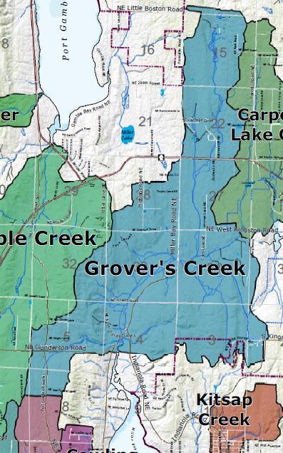
4 This amendment was requested by the Kitsap County Department of Community Development. C. Geographic Description This amendment affects the George s Corner LAMIRD outer boundary and two parcels in the vicinity of the SE corner of the intersection of Miller Bay Rd NE and SR-104. The subject site includes only the portions of the affected parcels that are currently within the George s Corner LAMIRD as depicted in Attachment A Maps 1 and 2. Both lots were created in November 2005 through Final Short Plat No (see Attachment C1). Tax Parcel ACCT # Short Plat #7278 Land Owner Total Acres Subject Acres Lot C KINGSTON CORNERS LLC 1.89 ~ Lot D BROUGHTON WILLIAM H 8.36 ~0.87 Parcels to the south and east are outside the LAMIRD and are undeveloped. Parcels to the north and west are inside the LAMIRD and are developed with commercial uses, including coffee shops, drug stores, banks, restaurants, grocery stores, and other types of retail businesses. The site is located in the Grover s Creek watershed, which flows southerly to Miller Bay. Grover s Creek (Type F Stream) is located to the east of the site along the eastern boundary of parcel (Plat 7278, Lot D). A wetland, wetland restoration area and wetland buffer mitigation area are located on parcel (Plat 7278, Lot D). The boundaries of parcel (Plat 7278, Lot C) were drawn to exclude the wetland buffer and wetland to the east that is associated with Grover s Creek. See Attachment C1 (Final Short Plat 7278) for wetland locations and Attachment A Map 3A for stream location. The site is not in a FEMA flood zone. Part of the site is categorized as a moderate geologically hazardous area due to moderate erosion hazard (see Attachment A Map 3A). The site is also categorized as a Category II critical aquifer recharge area (see Attachment A Map 3B). 4 of 15 7/16/2018

5 5 of 15 7/16/2018
6 2. Department Recommendation Having analyzed the proposed amendment and other alternatives, if applicable, the Department recommends: Adoption of the amendment: as proposed above as described in Alternative below with revisions described below with conditions described below Deferral of the amendment to a future docket Denial of the amendment A. Revisions None. B. Conditions None. C. Rational The establishment of a Type I LAMIRD outer boundary is a significant action under the Growth Management Act and the process to establish the George s Corner LAMIRD outer boundary was quite controversial. The process of proposing a LAMIRD boundary was repeated twice before finally adopted and then the boundary was appealed to the Central Puget Sound Growth Management Hearings Board [1000 Friends of Washington, et al v. Kitsap County; Case No c]. The primary complaint regarding the boundary in the appeal was that the County had not taken the required actions to minimize and contain development, including the inclusion of the SE corner of Miller Bay Rd NE and SR-104 in the LAMIRD. The Hearings Board upheld the County s LAMIRD outer boundary and found that the County chose to use the physical contours of the land and the presence of wetlands to define the boundary of the LAMIRD (Final Decision and Order (FDO), page 15) and that this is likely to result in permanent boundaries that are less subject to pressures for commercial expansion and sprawl (FDO, page 15) and that the George s Corner LAMIRD designation includes measures to minimize and contain the existing areas or uses as required by [the GMA] (FDO, page 16). The proposed LAMIRD boundary adjustment is in the public interest, consistent with the Comprehensive Plan, consistent with Growth Management Act criteria for drawing LAMIRD outer boundaries, and consistent with the findings in the Final Decision and Order for the Central Puget Sound Growth Management Hearings Board in the appeal 6 of 15 7/16/2018
7 of the 2004 establishment of the George s Corner LAMIRD. The proposed LAMIRD boundary will: Minimize and contain the LAMIRD by not increasing its overall size; Re-align the boundary to exclude critical areas and buffers from the LAMIRD area and setting the boundary where it will be permanent, control low-density sprawl, and maintain compatibility with adjacent rural lands; Prevent abnormally irregular boundaries by aligning with parcel lot lines where appropriate; and Include Lot D, which is consistent with the Hearings Board s interpretation of land appropriate for infill development that will be compatible with the use and scale of development at the intersection. 3. Other Alternatives Considered No alternatives were proposed during the development of this amendment. 4. Analysis Amendments to the Comprehensive Plan must be consistent with the criteria outlined in Kitsap County Code (KCC) Chapter Applicable criteria are analyzed below. A. General Decision Criteria (KCC A) For each proposed amendment to the Comprehensive Plan, the Planning Commission in reaching its recommendation, and the Board of Commissioners in making its decision, shall develop findings and conclusions, which demonstrate: 1. How circumstances related to the proposed amendment and/or the area in which the property affected by the proposed amendment is located have substantially changed since the adoption of the Comprehensive Plan or applicable development regulations; Staff Analysis: The circumstances related to the proposed amendment have substantially changed since the 2004 adoption of the George s Corner LAMIRD outer boundary. In 2005, the parcel (Tax Acct # ) at the SE corner of the intersection of Miller Bay Road NE and SR-104 was subdivided into four lots through Short Plat No (see Attachment C1), including the two lots subject to this amendment. The resulting parcel lines for these two lots did not align with the LAMIRD and zoning boundaries, resulting in split-zoned lots. Additionally, a wetland study completed for the short plat provides more specific information than available through the County GIS system, which helps inform this proposed amendment. 7 of 15 7/16/2018
8 2. How the assumptions upon which the Comprehensive Plan is based are no longer valid, or there is new information available which was not considered during the adoption of, or during the last annual amendment to, the Comprehensive Plan or development regulations; and Staff Analysis: There is new information available since the 2004 adoption of the George s Corner LAMIRD outer boundary. See section 4.A.1 above. 3. How the requested redesignation is in the public interest and the proposal is consistent with the Kitsap County Comprehensive Plan. Staff Analysis: The proposed LAMIRD boundary adjustment is in the public interest, consistent with the Comprehensive Plan, and consistent with Growth Management Act criteria for drawing LAMIRD outer boundaries. The proposed LAMIRD boundary will: Minimize and contain the LAMIRD by not increasing its overall size; Re-align the boundary to exclude critical areas and buffers from the LAMIRD area; Prevent abnormally irregular boundaries by aligning with parcel lot lines where appropriate and setting boundaries where they will be permanent; and Include only land area that would have been included in the LAMIRD originally had site-specific wetland delineations been used to draw the LAMIRD boundary. The proposed designation and classification changes are consistent with the current and future uses of the affected parcels and adjoining properties. B. Additional Decision Criteria (KCC B) In addition to the findings and conclusions above, for each proposed area-wide amendment, the Planning Commission in reaching its recommendation, and the Board of County Commissioners in making its decision, shall develop findings and conclusions which consider: 1. The proposed amendment meets concurrency requirements for transportation, sewer and water, and will not result in significant adverse impacts on adopted level of service standards for other public facilities and services, such as police, fire and emergency medical services, park services, and general government services; Staff Analysis: The proposed amendment will not have significant adverse impacts on adopted level of service standards. Public services are already provided for the George s Corner LAMIRD. Anticipated future capacity deficiencies for the North Kitsap School District will not be affected by this amendment. The intersection of 8 of 15 7/16/2018
9 Miller Bay Rd NE and SR-104 is projected to be capacity deficient by 2036 according to the 2016 Kitsap County Capital Facilities Plan. Additional improvements may be required of future development during applicable permitting and environmental review. 2. The proposed amendment is consistent with the goals, policies and objectives of development regulations, sub-area plan and the Comprehensive Plan and reflects the local circumstances of the county; Staff Analysis: The proposed amendment is consistent with the goals and policies of the Comprehensive Plan and reflects the local circumstances of the county. Specifically, this amendment closely reflects the following goals and policies in the Comprehensive Plan: Land Use Goal 13. Protect Kitsap County s unique rural character. Land Use Policy 52. For Type I Limited Area of More Intensive Rural Development (LAMIRD), allow for limited areas of more intensive rural development, including necessary public facilities and public services to serve the limited area as follows: Rural development consisting of the infill, development, or redevelopment of existing commercial, industrial, residential, or mixed-use areas, whether characterized as shoreline development, villages, hamlets, rural activity centers, or crossroads development and in accordance with Growth Management Act Requirements. Land Use Policy 54. In accordance with RCW 36.70A.070(5)(c): o to preserve rural character of the County, emphasize controlling rural development; assuring visual compatibility of rural development with the surrounding rural area, o reduce the inappropriate conversion of undeveloped land into sprawling, low-density development in the rural area, o protect critical areas, as provided in RCW 36.70A.060, and surface water and groundwater resources, and, o protect against conflicts with the use of agricultural, forest, and mineral resource lands designated under RCW 36.70A.170. This policy is implemented through Comprehensive Plan Land Use designations, zoning designations, and zoning code provisions. George s Corner is a Type I LAMIRD and was characterized as a crossroads development when it was established in The proposed amendment will adjust land use designations and zoning classifications to better align with and protect critical areas. 9 of 15 7/16/2018
10 Land Use Goal 14. Foster rural businesses and business opportunities on designated commercial and industrial lands in the rural area, while balancing protection of rural character. Land Use Policy 58. Encourage business growth in existing LAMIRDs while limiting business growth outside of LAMIRDs so as to not impact the rural character. The proposed LAMIRD boundary adjustment and designation/classification change will allow parcel (Plat 7278, Lot C) to be fully utilized for commercial development in a manner consistent with the intent of a Type I LAMIRD and the local circumstances of the George s Corner LAMIRD. 3. The subject parcel(s) is suitable for the requested land use designation based upon, but not limited to, access, provision of utilities, consistency with existing and planned uses, environmental constraints and compatibility with the neighborhood; Staff Analysis: The subject parcels are suitable for the proposed designations/classifications. Parcel (Plat 7278, Lot C) is outside existing critical areas and their buffers, has existing access to Miller Bay Rd NE and SR-104 via existing plat improvements, and an easement for a septic drainfield. Adjacent lots A and B are already developed with commercial uses, including a coffee shop and drug store. In 2016, a request was denied to redesignate a larger portion of parcel (Plat 7278, Lot D) from Rural Residential to Neighborhood Commercial. This amendment will remove the existing portion of Neighborhood Commercial designation, making this lot more compatible with existing environmental constraints and adjacent uses outside of the LAMIRD. 4. The proposed amendment does not materially affect the land uses and growth projections which are the basis for the Comprehensive Plan; Staff Analysis: The proposed amendment will not materially affect the land uses and growth projections that are the basis for the Comprehensive Plan. There are no population growth targets for Neighborhood Commercial areas and the proposed amendment will not increase population growth capacity in rural areas. 5. The proposed amendment does not materially affect the adequacy or availability of urban facilities and services to the immediate area or the overall area of the urban growth area; Staff Analysis: Not applicable the proposed amendment is not located in an Urban Growth Area. 10 of 15 7/16/2018
11 6. The proposed amendment is consistent with the Growth Management Act (GMA), Kitsap County-wide Planning Policy, state and local laws and other applicable interjurisdictional policies or agreements; Staff Analysis: The proposed amendment is consistent with the requirements of GMA, state and local laws and other applicable inter-jurisdictional policies and agreements. Growth Management Act The Growth Management Act sets forth the following criteria for evaluating the configuration of the outer boundary of a Type I LAMRD [WAC (6)(c)(i)(D)]: The need to preserve the character of existing natural neighborhoods and communities; Lots A, B, and C of Short Plat 7278 comprise an existing and integrated commercial area. Physical boundaries such as bodies of water, streets and highways, and land forms and contours; The proposed boundary will improve alignment of the LAMIRD with critical areas and their buffers. The prevention of abnormally irregular boundaries; and The proposed boundary will eliminate split-zoned parcels and better contain the LAMIRD through alignment with the southern boundary of Lots A and B, which are already developed with commercial uses. The ability to provide public facilities and public services in a manner that does not permit low-density sprawl Public facilities and services are already provided to George s Corner. County-wide Planning Policies The proposed amendment is consistent with the Kitsap County-wide Planning Policies (CPP); adopted on 5/11/2015 by Kitsap County Ordinance ). The proposed amendments are consistent with and implement Element D (Rural Land Uses and Development Patterns) of the CPP, specifically the following: Policy 2. Preserving rural land use and development patterns: 11 of 15 7/16/2018
12 o a. Rural Communities are already-existing residential and commercial areas of more intensive rural development designated in the Kitsap County Comprehensive Plan under RCW 36.70A In-fill is expected. Rural Communities should be serviced by transportation providers and other services consistent with the Levels of Service adopted by Kitsap County for roads and by Kitsap Transit for transit upon their designation as an area of more intensive rural development. Policy 4. Conserving small-scale natural resource use in rural areas: o c. The County's Comprehensive Plan policies shall support Rural Communities as locations of employment, a mix of housing types, and cultural activities for rural areas that primarily function as locations for service needs such as grocery stores, shopping, and community services, and small-scale cottage industries for the surrounding rural area. 7. The proposed amendment is consistent with and supports other plan elements and/or development regulations and, if not, what additional amendments to the plan and/or development regulations will be required to maintain consistency; Staff Analysis: The proposed amendment is consistent with and supports other plan elements and development regulations. 8. Any proposed amendments to rural areas and natural resource lands shall be supported by and dependent on population forecasts and the balance of nonurban population distributions, existing rural area and natural resource land densities and infill opportunities; and Staff Analysis: There are no population growth targets for Neighborhood Commercial areas and the proposed amendment will not increase population growth capacity in rural areas. 9. Any proposed changes to lands designated as natural resource lands shall recognize that natural resource designations are intended to be long-term designations and shall further be dependent on one or more of the following: Staff Analysis: Not applicable the proposed amendment does not change natural resource land designations. C. State Environmental Policy Act (SEPA) The Kitsap County SEPA official issued a SEPA threshold determination of nonsignificance (DNS; Attachment B1) for this amendment after having reviewed the SEPA environmental checklists prepared for this amendment (Attachment B2) and all of the other proposed Comprehensive Plan amendments. The SEPA official s review found 12 of 15 7/16/2018
13 that this amendment is not related to or dependent on any of the other amendments and therefore an independent SEPA threshold determination was made regarding this amendment. Notice of this SEPA threshold determination was: Filed with the Washington State Department of Ecology SEPA Register; Published in the Kitsap Sun newspaper (7/17/2018); and Integrated with other public announcements described in Section 5 below. The SEPA threshold determination and environmental checklist was also distributed to agencies with jurisdiction, the Department of Ecology, affected tribes, and each local agency or political subdivision whose public services would be changed as a result of implementation of the proposal. The SEPA comment period will run concurrently with the public comment period for the proposed amendment as described in Section 5 below. 5. Public Involvement and Outreach Kitsap County s public involvement and outreach in support of this amendment has exceeded the requirements of the Growth Management Act (RCW 36.70A) and Kitsap County Code (KCC 21.08). Public involvement and outreach in support of this amendment has included the following: An Online Open House with information about previous, current, and upcoming phases of the 2018 amendment process. A public comment period (11/27/ /15/2017) and a public hearing by the Kitsap County Board of Commissioners (12/11/2017) while setting the initial docket of amendments. Based on public comments, the Board of Commissioners added a review of affordable housing policies (i.e. the subject of this amendment) to the docket of amendments. Notifications and announcements regarding this comment period and public hearing included the following: Legal notice published in the Kitsap Sun newspaper (11/27/2017); Broadcast announcements via , text message, Facebook.com, Twitter.com, and Nextdoor.com; and Formal letters to Tribes with usual and accustom area in Kitsap County. Legal notice announcing the docket of amendments was published in the Kitsap Sun newspaper (1/8/2018). Presentations to various Kitsap County advisory groups and community groups. Comment Period and Public Hearing 13 of 15 7/16/2018
14 A new comment period regarding the proposed amendment (Attachment A), this staff report, and the SEPA determination (Attachment B1) will run through Tuesday, August 7, During this public comment period, the public may learn more about this and other amendments by: Visiting an Online Open House ( Attending one of the following Open Houses: July 10, 2018 (5:30-7:30 PM) at the Village Green Community Center (26159 Dulay Rd NE, Kingston) July 11, 2018 (5:30-7:30 PM) at the Givens Community Center (1026 Sidney Ave Rm # 115, Port Orchard) July 12, 2018 (5:30-7:30 PM) at the Silverdale Water District (5300 NW Newberry Hill Rd #100, Silverdale) Attending applicable Planning Commission meetings; or Contacting the staff listed in Section 6 below. To be included in the official record, written comments must be submitted to the Department of Community Development before 11:59 PM on Tuesday, August 7, 2018 using one of the following methods: Entered online via computer or mobile device; ed to CompPlan@co.kitsap.wa.us; Mailed to 614 Division St - MS36, Port Orchard, WA 98366; Dropped off at the Permit Center at 619 Division St, Port Orchard; or Dropped off at one of the open houses listed above. Oral and written testimony may also be made to the Kitsap County Planning Commission at the following public hearings in the Commissioner s Chambers on the 3 rd Floor of the Kitsap County Administration Building (619 Division St, Port Orchard): 7/17/2018 (5:30 PM); and 7/31/2018 (5:30 PM). Notifications and announcements regarding this comment period and public hearing include the following: Legal notice published in the Kitsap Sun newspaper; Broadcast announcements via , text message, Facebook.com, Twitter.com, and Nextdoor.com; Notice signs posted on site-specific amendment properties; Notices mailed to property owners near site-specific amendments and other geographically specific amendments; and Formal letters to Tribes with usual and accustomed area in Kitsap County. Additional public involvement and outreach will occur in October through December when the Kitsap County Board of Commissioners will be considering the amendments. 14 of 15 7/16/2018
15
Kitsap County Department of Community Development
 Kitsap County Department of Community Development Staff Report and Recommendation Annual Comprehensive Plan Amendment Process for 2018 Public Facility Designations and Park Classifications Update Report
STAFF REPORT. Permit Number: DJM Construction. Kitsap County Board of Commissioners; Kitsap County Planning Commission
 STAFF REPORT Permit Number: 15 00378 DJM Construction DATE: November 9, 2015 TO: FROM: Kitsap County Board of Commissioners; Kitsap County Planning Commission Katrina Knutson, AICP, Senior Planner, DCD
STAFF REPORT. Permit Number: Unlimited. Kitsap County Board of Commissioners; Kitsap County Planning Commission
 STAFF REPORT Permit Number: 15 00550 Unlimited DATE: March 2, 2016 TO: FROM: Kitsap County Board of Commissioners; Kitsap County Planning Commission Katrina Knutson, AICP, Senior Planner, DCD and Jeff
STAFF REPORT. Permit Number: Gonzalez. Kitsap County Board of Commissioners; Kitsap County Planning Commission
 STAFF REPORT Permit Number: 15 00657 Gonzalez DATE: March 2, 2016 TO: FROM: Kitsap County Board of Commissioners; Kitsap County Planning Commission Katrina Knutson, AICP, Senior Planner, DCD and Jeff Arango,
STAFF REPORT. Permit Number: Lee. Kitsap County Board of Commissioners; Kitsap County Planning Commission
 STAFF REPORT Permit Number: 15 00689 Lee DATE: March 2, 2016 TO: FROM: Kitsap County Board of Commissioners; Kitsap County Planning Commission Katrina Knutson, AICP, Senior Planner, DCD and Jeff Arango,
STAFF REPORT. Permit Number: Porter. Kitsap County Board of Commissioners; Kitsap County Planning Commission
 STAFF REPORT Permit Number: 15 00461 Porter DATE: November 9, 2015 TO: FROM: Kitsap County Board of Commissioners; Kitsap County Planning Commission Katrina Knutson, AICP, Senior Planner, DCD and Jeff
STAFF REPORT. Permit Number: Garland. Kitsap County Board of Commissioners; Kitsap County Planning Commission
 STAFF REPORT Permit Number: 15 00686 Garland DATE: February 25, 2016 TO: FROM: Kitsap County Board of Commissioners; Kitsap County Planning Commission Katrina Knutson, AICP, Senior Planner, DCD and Jeff
Kitsap County Department of Community Development. Administrative Staff Report
 Kitsap County Department of Community Development Administrative Staff Report Report Date: Application Complete Date: March 15, 2018 Application Submittal Date: March 12, 2018 Project Name: Nikki Lee Salon
STAFF REPORT. Permit Number: Laurier Enterprises, Inc. Kitsap County Board of Commissioners; Kitsap County Planning Commission
 STAFF REPORT Permit Number: 15 00740 Laurier Enterprises, Inc. DATE: December 18, 2015 TO: FROM: Kitsap County Board of Commissioners; Kitsap County Planning Commission Katrina Knutson, AICP, Senior Planner,
STAFF REPORT. Permit Number: Laurier Enterprises, Inc. Kitsap County Board of Commissioners; Kitsap County Planning Commission
 STAFF REPORT Permit Number: 15 00740 Laurier Enterprises, Inc. DATE: November 9, 2015 TO: FROM: Kitsap County Board of Commissioners; Kitsap County Planning Commission Katrina Knutson, AICP, Senior Planner,
891941, , : COMPREHENSIVE PLAN AMENDMENT, COMMUNITY PLAN AMENDMENT, AND AREA-WIDE MAP AMENDMENT
 Application Nos. 891941, 891909, 891940: COMPREHENSIVE PLAN AMENDMENT, COMMUNITY PLAN AMENDMENT, AND AREA-WIDE MAP AMENDMENT Amendments to designate five parcels as Rural Industrial Center in the Alderton
WENATCHEE PLANNING COMMISSION SCHEDULED MEETING October 15, 2014 WENATCHEE CITY HALL COUNCIL CHAMBERS 129 S. Chelan Avenue Wenatchee, WA AGENDA
 WENATCHEE PLANNING COMMISSION SCHEDULED MEETING October 15, 2014 WENATCHEE CITY HALL COUNCIL CHAMBERS 129 S. Chelan Avenue Wenatchee, WA 98801 AGENDA I. CALL TO ORDER: 5:30 PM II. ADMINISTRATIVE AFFAIRS
STAFF REPORT And INFORMATION FOR THE HEARING EXAMINER
 KITSAP COUNTY DEPARTMENT OF COMMUNITY DEVELOPMENT 614 DIVISION STREET MS-36, PORT ORCHARD WASHINGTON 98366-4682 Louisa Garbo, Director (360) 337-7181 FAX (360) 337-4925 HOME PAGE - www.kitsapgov.com/dcd/
Kitsap County Department of Community Development. Administrative Staff Report
 Kitsap County Department of Community Development Administrative Staff Report Report Date: Application Submittal Date: October 25, 2017 Application Complete Date: October 25, 2017 Project Name: John s
Kitsap County Department of Community Development. Staff Report and Administrative Decision
 Kitsap County Department of Community Development Report Date: Staff Report and Administrative Decision Application Complete Date: March 19, 2018 Application Submittal Date: March 19, 2018 To: Seth Hanson,
Kitsap County Hearing Examiner
 January 25, 2016 ADMINISTRATION BUILDING, 619 DIVISION ST, MS-36 PORT ORCHARD, WA 98366 http://www.kitsapgov.com/dcd/lu_env/he/ (360) 337-5777 NOTICE OF HEARING EXAMINER DECISION To: Interested Parties
Staff Report to the Clallam County Planning Commission March 2, 2004 Page 1
 March 2, 2004 Page 1 Comprehensive Plan and Zoning Map Amendment REZ2003-00001, Staff Report Clallam County Department of Community Development January 27, 2004 Prepared by the Clallam County Department
PAPRlamird4-Lairds Corner
 PAPRlamird4-Lairds Corner Lamird Report This report provides the written record of local circumstances that explains how the Lairds Corner LAMIRD ( this lamird ) fits within the rural element goals of
STAFF REPORT and INFORMATION FOR THE HEARING EXAMINER. Project: Westphal Accessory Dwelling Unit (ADU)
") KITSAP COUNTY DEPARTMENT OF COMMUNITY DEVELOPMENT 614 DIVISION STREET MS-36, PORT ORCHARD WASHINGTON 98366-4682 LARRY KEETON, DIRECTOR (360) 337-7181 FAX (360) 337-4925 HOME PAGE - www.kitsapgov.com STAFF
KITSAP COUNTY DEPARTMENT OF COMMUNITY DEVELOPMENT 614 DIVISION STREET MS-36, PORT ORCHARD WASHINGTON 98366-4682 LARRY KEETON, DIRECTOR (360) 337-7181 FAX (360) 337-4925 HOME PAGE - www.kitsapgov.com STAFF
Kitsap County Department of Community Development. Notice of Administrative Decision
 Kitsap County Department of Community Development Notice of Administrative Decision Date: March 27, 2018 To: Tammy Mabry, tammystattoostudio@gmail.com Interested Parties and Parties of Record RE: Permit
Kitsap County Department of Community Development. Notice of Hearing Examiner Decision
 Kitsap County Department of Community Development 10/09/2018 Notice of Hearing Examiner Decision To: RE: Interested Parties and Parties of Record Project Name: Green-Shire Accessory Dwelling Unit (ADU)
BEFORE THE HEARING EXAMINER FOR THURSTON COUNTY
 COUNTY COMMISSIONERS Cathy Wolfe District One Diane Oberquell District Two Robert N. Macleod District Three HEARING EXAMINER BEFORE THE HEARING EXAMINER FOR THURSTON COUNTY In the Matter of the Application
MIDWAY CITY Municipal Code
 MIDWAY CITY Municipal Code TITLE 9 ANNEXATION CHAPTER 9.01 PURPOSE CHAPTER 9.02 GENERAL REQUIREMENTS CHAPTER 9.03 PROPERTY OWNER INITIATION OF ANNEXATION CHAPTER 9.04 PROCEDURES FOR CONSIDERATION OF PETITION
GENERAL DESCRIPTION STAFF RECOMMENDATION IMPLEMENTATION REQUIREMENTS
 Application No.: 891418 Applicant: AREA-WIDE MAP AMENDMENT Rezone two parcels from Moderate Density Single Family (MSF) to Neighborhood Center (NC) and Employment Center (EC). Charles Bitton GENERAL DESCRIPTION
APPLICATION INFORMATION Site Information Parcel Number Street Address Applicant Information Name Street Address City State Zip
 Comprehensive Plan Amendment City of Puyallup Development Services 333 S. Meridian Puyallup, WA 98371 Phone: 253-864-4165 www.cityofpuyallup.org Submittal Checklist Application is signed and dated 5 Copies
Kitsap County Department of Community Development. Notice of Hearing Examiner Decision
 Kitsap County Department of Community Development 11/20/18 Notice of Hearing Examiner Decision To: RE: Interested Parties and Parties of Record Project Name: Sanson Accessory Dwelling Unit Conditional
PAPRlamird5-Four Seasons
 PAPRlamird5-Four Seasons Lamird Report This report provides the written record of local circumstances that explains how the 4 Seasons LAMIRD ( this lamird ) fits within the rural element goals of the Growth
TREASURE COAST REGIONAL PLANNING COUNCIL M E M O R A N D U M
 TREASURE COAST REGIONAL PLANNING COUNCIL M E M O R A N D U M To: Council Members AGENDA ITEM 6A From: Date: Subject: Staff May 20, 2011 Council Meeting Local Government Comprehensive Plan Review Draft
BEFORE THE HEARING EXAMINER FOR THURSTON COUNTY
 COUNTY COMMISSIONERS Cathy Wolfe District One Diane Oberquell District Two Robert N. Macleod District Three HEARING EXAMINER BEFORE THE HEARING EXAMINER FOR THURSTON COUNTY In the Matter of the Application
2013 APPLICATION FOR URBAN GROWTH AREA AMENDMENT TO PIERCE COUNTY COMPREHENSIVE PLAN
 2013 APPLICATION FOR URBAN GROWTH AREA AMENDMENT TO PIERCE COUNTY COMPREHENSIVE PLAN An Urban Growth Area Amendment (UGA) is a proposed change or revision to the designated Comprehensive Urban Growth Area
Craig L. Miller, Attorney 230 East Fifth Street Port Angeles, WA 98362
 Comprehensive Plan and Zoning Map Amendment REZ2003-00003, Staff Report Clallam County Department of Community Development Prepared by the Clallam County Department of Community Development, Planning Division
19.12 CLUSTER RESIDENTIAL DISTRICT
 Chapter 19.12 CLUSTER RESIDENTIAL DISTRICT (Adopted 12/22/2003; Ordinance #0061970). Amended 7/3/17, Ordinance #079100. Section 19.12.010 - Declaration of Intent. The Cluster Residential District provides
BONNER COUNTY PLANNING DEPARTMENT PLANNING & ZONING COMMISION STAFF REPORT APRIL 19, 2018
 BONNER COUNTY PLANNING DEPARTMENT PLANNING & ZONING COMMISION STAFF REPORT APRIL 19, 2018 Project Name: File Number,Type: Request: Legal Description: Location: Parcel Size: Parcel # Applicant: Project
Land Use Code Streamlining 2012
 City of Tacoma Planning Commission Land Use Code Streamlining 2012 FINDINGS AND RECOMMENDATIONS TACOMA PLANNING COMMISSION August 1, 2012 A. SUBJECT: Streamlining the Land Use Regulatory Code to reduce
Procedures For Collecting and Monitoring Data
 DRAFT Kitsap County Buildable Lands Program Procedures For Collecting and Monitoring Data Page 1 12/1/05 Introduction This procedures report is intended to provide guidelines for Kitsap County and its
Permit Number: Edwards Mountain View Meadows
 Notes and comments on 2016 Comp Plan Tom Nevins - Nov 24, 2015 These notes are being prepared prior to any public comment review, public hearing input, or Planning Commission discussion. These are initial
DOUGLAS COUNTY SUBDIVISION RESOLUTION Article 4 Preliminary Plan 10/13/2015
 ARTICLE 4 PRELIMINARY PLAN 401 Intent An in-depth analysis of the proposed subdivision, including a review of the design considering the ability to obtain water and sanitation, identified geologic hazards,
Larimer County Planning Dept. Procedural Guide for 1041 PERMITS
 - Larimer County Planning Dept. Procedural Guide for 1041 PERMITS PLEASE NOTE: A PRE-APPLICATION CONFERENCE IS REQUIRED PRIOR TO SUBMITTING THIS APPLICATION. PURPOSE: State Statutes allow local governments
4.2 LAND USE INTRODUCTION
 4.2 LAND USE INTRODUCTION This section of the EIR addresses potential impacts from the Fresno County General Plan Update on land use in two general areas: land use compatibility and plan consistency. Under
Thurston County Planning Department BOARD OF COUNTY COMMISSIONERS PUBLIC HEARING DRAFT AMENDMENTS TO THE CRITICAL AREAS REGULATIONS. Chapter 24.
 Thurston County Planning Department BOARD OF COUNTY COMMISSIONERS PUBLIC HEARING DRAFT AMENDMENTS TO THE CRITICAL AREAS REGULATIONS Chapter 24.01 GENERAL PROVISIONS Chapter 24.01 6/4/2012 GENERAL PROVISIONS
BEFORE THE HEARINGS EXAMINER FOR THE CITY OF BREMERTON
 BEFORE THE HEARINGS EXAMINER FOR THE CITY OF BREMERTON In the Matter of the Application of ) NO. PL03-0017 ) Rainier Vista Bill Bakker ) ) FINDINGS, CONCLUSIONS For Approval of a Preliminary Plat. ) AND
/ Planning and Zoning Commission Staff Report Jay Walker- All Terra Consulting - RZ
 / Planning and Zoning Commission Staff Report Jay Walker- All Terra Consulting - Hearing Date: January 17, 2019 Development Services Department Applicant: Jay Walker All Terra Consulting Staff: Jennifer
City of Bellingham Urban Growth Area - Land Supply Analysis Summary
 City of Bellingham Urban Growth Area - Land Supply Analysis Summary Population & Employment Growth Forecasts APPENDIX D, ATTACHMENT 3 The ECONorthwest Whatcom County Population & Economic Forecasts report
4. If any perennial surface water passes through or along the property lines of the acreage, a minimum of 200 feet or frontage should be required.
 b. Provide adequate acreage for appropriate productive use of rural residential land, such as small numbers of livestock, large gardens, etc. 3. Minimum of 200 feet of frontage on an improved county or
Planning Commission Hearing Date: 2/21/2017 Board of County Commissioners Hearing Date: 3/8/2017
 COMMISSIONERS: DARRYL GLENN (PRESIDENT) MARK WALLER (PRESIDENT PRO TEMPORE) STAN VANDERWERF LONGINOS GONZALEZ PEGGY LITTLETON PLANNING AND COMMUNITY DEVELOPMENT DEPARTMENT CRAIG DOSSEY, EXECUTIVE DIRECTOR
Thurston County Planning Department PUBLIC HEARING DRAFT. AMENDMENTS TO THE CRITICAL AREAS REGULATIONS Chapter /18/2011 GENERAL PROVISIONS
 Thurston County Planning Department PUBLIC HEARING DRAFT AMENDMENTS TO THE CRITICAL AREAS REGULATIONS Chapter 24.01 11/18/2011 Chapter 24.01 GENERAL PROVISIONS GENERAL PROVISIONS Sections: 24.01.005 Short
Planning Department Oconee County, Georgia
 Planning Department Oconee County, Georgia STAFF REPORT REZONE CASE #: 6985 DATE: October 31, 2016 STAFF REPORT BY: Andrew C. Stern, Planner APPLICANT NAME: Williams & Associates, Land Planners PC PROPERTY
Kitsap County Department of Community Development. Staff Report
 Kitsap County Department of Community Development Staff Report Report Date: Application Complete Date: August 14, 2017 Application Submittal Date: August 14, 2017 To: Hercules & Laura Hubbell, laura@allcountyoperations.com
SUBURBAN AND URBAN RESIDENTIAL LAND USE
 SUBURBAN AND URBAN RESIDENTIAL LAND USE GOAL 1 DISCOURAGE URBAN AND SUBURBAN DEVELOPMENT OUTSIDE INCORPORATED AREAS IN WHITMAN COUNTY, EXCEPT WITHIN DESIGNATED UNINCORPORATED COMMUNITIES, AND THOSE AREAS
MINUTE ORDER BONNER COUNTY COMMISSIONERS PUBLIC HEARING MINUTES AUGUST 6, 2015
 MINUTE ORDER BONNER COUNTY COMMISSIONERS PUBLIC HEARING MINUTES AUGUST 6, 2015 CALL TO ORDER: Chair Cary Kelly called the Bonner County Commissioners hearing to order at 1:00 p.m. in the 3rd floor meeting
APPLICATION FOR SUBDIVISION APPROVAL OF A SKETCH PLAN with checklist
 Prior to filing any application for SUBDIVISION approval, the applicant shall request in writing that the zoning administrator schedule a pre-submission conference. APPLICATION TO THE PLANNING BOARD TOWN
Yakima County Public Services Department Planning Division
 Yakima County Public Services Department Planning Division Yakima County s 2017 Review of its UGAs and Permitted Densities (as required by the Growth Management Act) Urban Growth Area for City of Zillah
Spirit Lake North, LLC
 BONNER COUNTY PLANNING DEPARTMENT PLANNING AND ZONING COMMISSION STAFF REPORT FOR March 1, 2018 Project Name: Amendment & Zone Change: Spirit Lake North, LLC File Number,Type: AM 162-18/ZC365-18 Request:
8Land Use. The Land Use Plan consists of the following elements:
 8Land Use 1. Introduction The Land Use Plan consists of the following elements: 1. Introduction 2. Existing Conditions 3. Opportunities for Redevelopment 4. Land Use Projections 5. Future Land Use Policies
Mike & Sherry Dudley Rezone, RZ
 / Planning and Zoning Staff Report Mike & Sherry Dudley Rezone, RZ2019-0005 Hearing Date: April 18, 2019 Development Services Department Applicant: Mike & Sherry Dudley Staff: Deb Root, 454-7340 droot@canyonco.org
Chapter CONCURRENCY
 Chapter 20.180 CONCURRENCY Sections: 20.180.001 Purpose. 20.180.002 Authority. 20.180.003 Definitions 20.180.004 Exempt development. 20.180.005 Capacity evaluation required for a change in use. 20.180.006
Burlington Unincorporated Community Plan
 Burlington Unincorporated Community Plan June 30, 2010 Meeting Page 1 of 24 Table of Contents (Page numbers to be inserted) I. Background a. Location and Community Description b. Planning of Unincorporated
CCC XXX Rural Neighborhood Conservation (NC)
") CCC 33.10.XXX Rural Neighborhood Conservation (NC) Purpose: Maintain low density rural residential areas and associated uses commonly found in rural areas consistent with the local character of the distinctive
CCC 33.10.XXX Rural Neighborhood Conservation (NC) Purpose: Maintain low density rural residential areas and associated uses commonly found in rural areas consistent with the local character of the distinctive
PROVO CITY MUNICIPAL ANNEXATION GUIDE
 COMMUNITY DEVELOPMENT PROVO CITY MUNICIPAL ANNEXATION GUIDE This guide has been prepared to outline the procedures and requirements of annexing unincorporated territory into Provo City. Annexations are
CHAPTER 2 VACANT AND REDEVELOPABLE LAND INVENTORY
 CHAPTER 2 VACANT AND REDEVELOPABLE LAND INVENTORY CHAPTER 2: VACANT AND REDEVELOPABLE LAND INVENTORY INTRODUCTION One of the initial tasks of the Regional Land Use Study was to evaluate whether there is
Staff Report: Date: Applicant: Property Identification: Acreage of Request: Current Zoning of Requested Area: Requested Action: Attached:
 Staff Report: Completed by Jeff Palmer Director of Planning & Zoning Date: November 7, 2018, Updated November 20, 2018 Applicant: Greg Smith, Oberer Land Developer agent for Ronald Montgomery ET AL Property
Planning Department Oconee County, Georgia STAFF REPORT
 Planning Department Oconee County, Georgia STAFF REPORT REZONE CASE #: 7332 DATE: November 28, 2017 STAFF REPORT BY: Gabriel Quintas, Planner APPLICANT NAME: Smith Planning Group PROPERTY OWNER: John Hadden
COUNTY OF SAN MATEO PLANNING AND BUILDING DEPARTMENT
 COUNTY OF SAN MATEO PLANNING AND BUILDING DEPARTMENT DATE: April 16, 2015 TO: FROM: Zoning Hearing Officer Planning Staff SUBJECT: Consideration of a Coastal Development Permit and Planned Agricultural
Guide to Combined Preliminary and Final Plats
 Guide to Combined Preliminary and Final Plats Introduction The Douglas County is committed to providing open, transparent application processes to the public. This Guide is provided to assist anyone interested
Land Use. Land Use Categories. Chart 5.1. Nepeuskun Existing Land Use Inventory. Overview
 Land Use State Comprehensive Planning Requirements for this Chapter A compilation of objectives, policies, goals, maps and programs to guide the future development and redevelopment of public and private
Planning Justification Report
 Planning Justification Report, Township of Puslinch FARHI HOLDINGS CORPORATION Updated January 27, 2017 Zelinka Priamo Ltd. Page i TABLE OF CONTENTS Page No. 1.0 1.1 1.2 1.3 2.0 2.1 2.2 2.3 2.4 2.5 3.0
O-I (Office-Institutional) and AG-1(Agricultural)
 and AG-1(Agricultural)") PROPERTY INFORMATION ADDRESS 3503 and 3505 Bethany Bend DISTRICT, LAND LOTS 2/1 973 and 974 OVERLAY DISTRICT State Route 9 PETITION NUMBERS EXISTING ZONING O-I (Office-Institutional) and AG-1(Agricultural)
PROPERTY INFORMATION ADDRESS 3503 and 3505 Bethany Bend DISTRICT, LAND LOTS 2/1 973 and 974 OVERLAY DISTRICT State Route 9 PETITION NUMBERS EXISTING ZONING O-I (Office-Institutional) and AG-1(Agricultural)
Draft Model Access Management Overlay Ordinance
 Draft Model Access Management Overlay Ordinance This model was developed using the City of Hutchinson and the Trunk Highway 7 corridor. The basic provisions of this model may be adopted by any jurisdiction
French, Bruce. The applicant is requesting a zone change from Suburban to Rural Service Center.
 BONNER COUNTY PLANNING DEPARTMENT PLANNING AND ZONING COMMISSION STAFF REPORT FOR FEBRUARY 2, 2017 Project Name: French, Bruce File Number,Type: ZC358-16, Zone Change Request: The applicant is requesting
TELLER COUNTY PLANNING COMMISSION Regular Meeting: February 13, 2007
 TELLER COUNTY PLANNING COMMISSION Regular Meeting: February 13, 2007 Agenda Item V Consideration of a request from Spring Meadow Ranch Partnership, LLLP, (William L. Page, General Partner) and Carol Plummer,
MASTER INTERLOCAL AGREEMENT FOR GROWTH MANAGEMENT ACT IMPLEMENTATION IN YAKIMA COUNTY TABLE OF CONTENTS
 MASTER INTERLOCAL AGREEMENT FOR GROWTH MANAGEMENT ACT IMPLEMENTATION IN YAKIMA COUNTY TABLE OF CONTENTS I. PREAMBLE A. Purpose... 1 B. Background... 2 II. AGREEMENT A. Parties to Agreement... 3 B. Authority...
Marion County Board of County Commissioners
 Marion County Board of County Commissioners Date: 6/4/217 P&Z: 9/25/217 BCC Transmittal: 1/17/217 BCC Adopt: TBD Amendment No: 217-L6 Type of Application Large-Scale Comp Plan Amendment Request: Change
Initial Project Review
 Pierce County Department of Planning and Land Services, 2401 South 35th Street, Tacoma, WA (253) 798-7037 Initial Project Review Major Amendment to Preliminary Plat: Hawks Ridge Division 1 Application
Project File #: SF Project Name: Jackson Ranch Filing No. 4 Parcel Nos.: , and
 COMMISSIONERS: DARRYL GLENN (PRESIDENT) MARK WALLER (PRESIDENT PRO TEMPORE) STAN VANDERWERF LONGINOS GONZALEZ PEGGY LITTLETON PLANNING AND COMMUNITY DEVELOPMENT DEPARTMENT CRAIG DOSSEY, EXECUTIVE DIRECTOR
REPORT OF THE PLANNING AND DEVELOPMENT DEPARTMENT FOR APPLICATION FOR REZONING ORDINANCE TO PLANNED UNIT DEVELOPMENT MAY 18, 2017
 BEL REPORT OF THE PLANNING AND DEVELOPMENT DEPARTMENT FOR APPLICATION FOR REZONING ORDINANCE 2016-805 TO PLANNED UNIT DEVELOPMENT MAY 18, 2017 The Planning and Development Department hereby forwards to
BOUNDARY LINE ADJUSTMENT
 DEPARTMENT OF COMMUNITY DEVELOPMENT 621 Sheridan Street, Port Townsend, WA 98368 Tel: 360.379.4450 Fax: 360.379.4451 Web: www.co.jefferson.wa.us/communitydevelopment E-mail: dcd@co.jefferson.wa.us BOUNDARY
RE: 6. GILL/GREEN COMPREHENSIVE PLAN AMENDMENT, REZONING AND PRELIMINARY PLAT
 commission memo DATE: Thursday - August 9, 2018 TO: Marion Planning & Zoning Commission FROM: David N. Hockett, AICP Principal Planner RE: 6. GILL/GREEN COMPREHENSIVE PLAN AMENDMENT, REZONING AND PRELIMINARY
NOTICE OF HEARING EXAMINER DECISION
 June 20, 2016 ADMINISTRATION BUILDING, 619 DIVISION ST, MS-36 PORT ORCHARD, WA 98366 http://www.kitsapgov.com/dcd/lu_env/he/ (360) 337-5777 cblackburn@co.kitsap.wa.us NOTICE OF HEARING EXAMINER DECISION
Bethel Romanian Church - Rezone, RZ
 / Planning and Zoning Staff Report Bethel Romanian Church - Rezone, RZ2018-0023 Hearing Date: November 15, 2018 Development Services Department Owners: Bethel Romanian Church, Corp. Applicant: Viorel Botos
PRELIMINARY SUBDIVISION PLAN APPLICATION INSTRUCTIONS
 City of Chesapeake Department of Planning Post Office Box 15225 Chesapeake, Virginia 23328-5225 (757) 382-6176 FAX (757) 382-6406 PRELIMINARY SUBDIVISION PLAN APPLICATION INSTRUCTIONS PURPOSE A preliminary
Kitsap County Department of Community Development. Hearing Examiner Staff Report and Recommendation
 Kitsap County Department of Community Development Hearing Examiner Staff Report and Recommendation Report Date: Application Submittal Date: May 7, 2018 Hearing Date: January 24, 2019 Application Complete
Report to the Plan Commission December 19, 2011
 Report to the Plan Commission Legistar I.D. #24825, Extraterritorial Certified Survey Map Requested Action: Consideration of a two-lot Certified Survey Map (CSM) of the Keryluk-Wee property located at,,
Guide to Preliminary Plans
 Guide to Preliminary Plans Introduction The Douglas County is committed to providing open, transparent application processes to the public. This Guide is provided to assist anyone interested in the procedures
Reviewing Growth Management Planning for Housing
 Washington Research Council BRIEFLY Policy makers should avoid overly proscriptive regulation of the housing market, maximizing opportunities for residential and commercial development that is consistent
United States Post Office and Multi-Family Residential; and, Single- Family Residence with an Apartment
 Planning Commission File No.: AME2013 0009 January 9, 2014 Page 2 of 9 Existing Land Use: United States Post Office and Multi-Family Residential; and, Single- Family Residence with an Apartment Surrounding
Staff Report: Date: Applicant: Property Identification: Acreage of Request: Current Zoning of Requested Area: Requested Action: Attached:
 Staff Report: Completed by Jeff Palmer Director of Planning & Zoning Date: November 7, 2018 Applicant: Greg Smith, Oberer Land Developer agent for Ronald Montgomery ET AL Property Identification: Frontage
COUNTY HEARING EXAMINER
 DECISION of the SNOHOMISH COUNTY HEARING EXAMINER DATE OF DECISION: March 22, 2010 PLAT/PROJECT NAME: MUSTACH #2 APPLICANT/ LANDOWNER: FILE NO.: TYPE OF REQUEST: DECISION (SUMMARY): John and Julie Mustach
CITY OF FERNDALE HEARING EXAMINER
 CITY OF FERNDALE HEARING EXAMINER RE: Planned Unit Development ) 16001-PUD Preliminary Plat ) 16018-SE Plat Variance ) 16002-VAR Application by ) ) MD General, L.L.C. ) FINDINGS OF FACT, Malloy Heights
STAFF RECOMMENDATION
 Snohomish County STAFF RECOMMENDATION Planning & Development Services Commercial/Land Use Division Project File Number: 06-126088-000-00-LU Tax Acct. Number: 270516-003-043-00 Hearing Date: July 18, 2007
TREASURE COAST REGIONAL PLANNING COUNCIL M E M O R A N D U M. To: Council Members AGENDA ITEM 10A
 TREASURE COAST REGIONAL PLANNING COUNCIL M E M O R A N D U M To: Council Members AGENDA ITEM 10A From: Date: Subject: Staff April 20, 2007 Council Meeting Local Government Comprehensive Plan Review Draft
Implementation. Approved Master Plan and SMA for Henson Creek-South Potomac 103
 Implementation Approved Master Plan and SMA for Henson Creek-South Potomac 103 104 Approved Master Plan and SMA for Henson Creek-South Potomac Sectional Map Amendment The land use recommendations in the
INDIAN RIVER COUNTY, FLORIDA. The Honorable Members of the Planning and Zoning Commission DEPARTMENT HEAD CONCURRENCE
 Public Hearing Legislative INDIAN RIVER COUNTY, FLORIDA M E M O R A N D U M TO: The Honorable Members of the Planning and Zoning Commission DEPARTMENT HEAD CONCURRENCE Robert M. Keating, AICP; Community
Rural Element Update. May 21, 2013
 Rural Element Update May 21, 2013 1 Today s presentation Issues Planning Commission Recommendation Staff Recommendations Schedule 2 Issue 1 Variety of Rural Densities Compliance Order: The Board noted
TRANSFERABLE DEVELOPMENT RIGHTS PROCESS GUIDE
 TRANSFERABLE DEVELOPMENT RIGHTS PROCESS GUIDE Clear Creek County Planning Department P.O. Box 2000 Georgetown, Colorado 80444 (303) 679-2436 - phone (303) 569-1103 - fax 1 PURPOSE: A Transfer of Development
Finnerty, Shawn & Lori Water Front Setback
 BONNER COUNTY PLANNING DEPARTMENT PLANNING AND ZONING COMMISSION STAFF REPORT FOR NOVEMBER 2, 2017 Project Name: Finnerty, Shawn & Lori Water Front Setback File Number, Type: FILE #V492-17, Variance Request
Urban Fringe Development Area Project Update And Staff Recommendation
 Urban Fringe Development Area Project Update And Staff Recommendation July 30, 2008 July 30, 2008 Urban Fringe Development Area Project Table of Contents Introduction, Background, and Next Steps 3 Constraints:
Final. Chapter Four: Land Use
 Chapter Four: Land Use Purpose and Intent Goals and Policies Existing Land Use Patterns AICUZ Airport Overlay Zone Zoning Existing Land Use Land Use Designations Land Use Demand and Forecast Existing Population
REPORT TO THE SHELBY COUNTY PLANNING COMMISSION From the Department of Development Services Planning Services. February 4, 2019
 REPORT TO THE SHELBY COUNTY PLANNING COMMISSION From the Department of Development Services Planning Services February 4, 2019 Case No. Request for Rezoning Approval From E-1 to E-2 SD This is a request
MEMORANDUM. Critical Areas Ordinance Density Requirements
 COUNTY COMMISSIONERS Creating Solutions for Our Future Cathy Wolfe District One Sandra Romero District Two Karen Valenzuela District Three PLANNING DEPARTMENT Scott Clark Director MEMORANDUM TO: FROM:
ARTICLE XI - CONSERVATION SUBDIVISIONS
 ARTICLE XI - CONSERVATION SUBDIVISIONS Section 1101: Purpose and Intent. This Article is intended to provide for residential subdivisions that are designed based first and foremost on the preservation