TREASURE COAST REGIONAL PLANNING COUNCIL M E M O R A N D U M. To: Council Members AGENDA ITEM 10A
|
|
|
- Jemima Turner
- 5 years ago
- Views:
Transcription
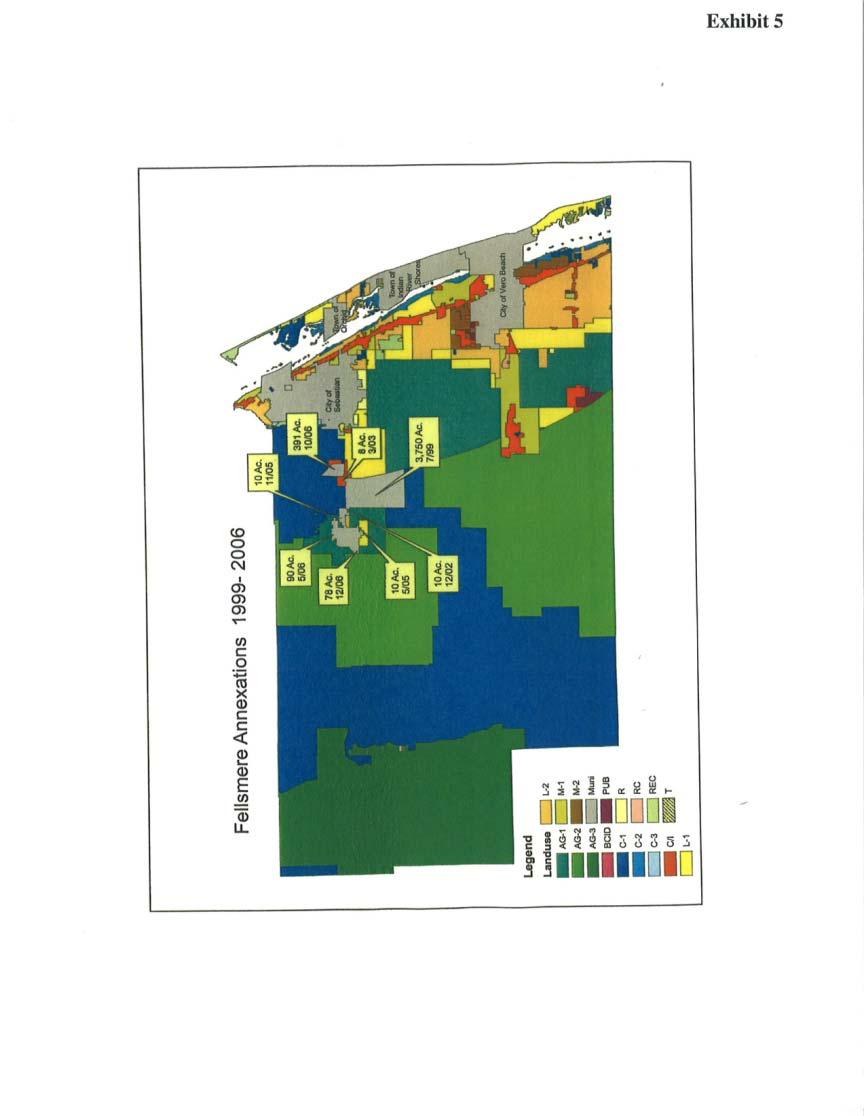
1 TREASURE COAST REGIONAL PLANNING COUNCIL M E M O R A N D U M To: Council Members AGENDA ITEM 10A From: Date: Subject: Staff April 20, 2007 Council Meeting Local Government Comprehensive Plan Review Draft Amendments to the City of Fellsmere Comprehensive Plan DCA Reference No Introduction The Local Government Comprehensive Planning and Land Development Regulation Act, Chapter 163, Florida Statutes, requires that Council review local government comprehensive plan amendments prior to their adoption. Under the provisions of this law, the Department of Community Affairs (DCA) prepares an Objections, Recommendations, and Comments (ORC) Report on a proposed amendment only if requested to do so by the local government, the regional planning council, an affected person, or if an ORC Report is otherwise deemed necessary by the DCA. If the local government requests DCA to prepare an ORC Report, then Council must provide DCA with its own objections, recommendations for modification, and comments on the proposed amendments within 30 days of its receipt. Background The City of Fellsmere is located in the north central portion of Indian River County (Exhibit A). Historically, the City developed as a small market center for the agriculture industry. The City has a population of 4,600 people, which grows to approximately 7,000 people during the height of the citrus season. The characteristics of the population of Fellsmere are quite different from those of the County as a whole. The City s median age is 25, while the County s is 46. In the 2000 Census, the City s per capita income was $10,000, while the County s per capita income was $30, % of Fellsmere households are at or below the poverty level, while the County has 11% of households with this status. In 2003, the City adopted a new Comprehensive Plan, necessitated in part by the annexation in 1999 of 3,480 acres of vacant land located in the southwest corner of the I- 95 and CR 512 interchange (see Exhibits). The City annexed more land in 2006, adding approximately 90 acres west of I-95 and over 390 acres east of the I-95 interchange.
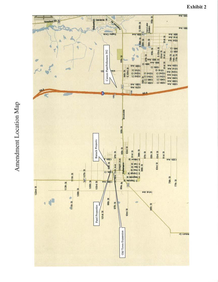
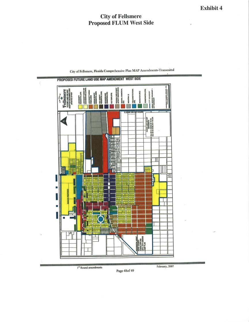
2 These newly annexed lands are the subject of two of the proposed Future Land Use Map (FLUM) amendments in this package. During the last 2 years, the City has undertaken the following economic development efforts: Annexation of additional land. Establishment of a Community Redevelopment Area (CRA). Development of a streamlined development review process. Institution of new land development codes. The CRA was established in 2005 to eliminate blight and promote infill and redevelopment in the traditional downtown area known as Old Town. The City of Fellsmere is proposing four amendments to the FLUM and text amendments to the Future Land Use Element and the Transportation Element of the City Comprehensive Plan. The City has requested a formal review of the proposed amendments by the DCA. Evaluation The FLUM amendments are summarized in Table 1. The location of the subject properties are shown on the attached maps (see Exhibits 2, 3, and 4). 2
3 Table 1 Proposed Amendments to the Future Land Use Map City of Fellsmere Comprehensive Plan DCA Reference No Amendment Number/Name 1. Carson Platt/ Fellsmere 392 (CPA-01-07) 2. Banack Family Part. (CP C) 3. Patel Properties (CPA-01-07B) 4. Old Town Expansion (City Initiated) Approx. Acreage Current FLUM Designation AG-1 (80.0 ac.) C/I (312.0 ac.) Proposed FLUM Designation REAC (41.0 ac.) LDMXN (351.0 ac.) 90.5 A LDR 20.0 LDR OTD 16.0 Total: LDR (4.7 ac.) MDR (8.9 ac.) NC (1.5 ac.) PIN (.90 ac.) OTD Approximate Location NE corner of I-95 and CR 512 interchange. West of Willow St., between 99 St. & 101 St.. North of South Carolina Ave. North of CR 512, east of Orange St., West of Pine St. and South side of South Carolina Ave. City LDMXN LDR MDR NC OTD PIN REAC County AG-1 C/I Key to FLUM Designations Low Density Mixed Neighborhood Low Density Residential Medium Density Residential Neighborhood Commercial Old Town District Public Institutional Regional Employment Activity Center Agricultural Commercial Industrial Future Land Use Map Amendments 1. (CPA-01-07) Carson Platt/ Fellsmere 392 The subject property is approximately 392 acres of land annexed into Fellsmere in October of The property is generally located in the northeast corner of the I- 95/CR 512 interchange. Under the Indian River County Comprehensive Plan, 312 acres of the parcel was designated as Commercial/Industrial, the highest intensity under the County s plan. The remaining 80 acres had a FLUM designation of Agriculture (AG-1). Fellsmere proposes to designate 41 acres of the parcel as Regional Employment Activity Center (REAC) and the remaining land as Low Density Mixed Neighborhood (LDMXN). The property is currently vacant. The existing land use to the north is Conservation but the County leases the area from the St. Johns River Water Management District 3
4 (SJRWMD) to operate a gun range. The property to the east has existing industrial uses and is designated for Commercial/Industrial (C/I) under the County Comprehensive Plan. The properties to the south are largely undeveloped and have a FLUM designation of C/I (IRC). I-95 borders the property to the west. The amendment is proposed to allow regional employment activity center development (commercial and/or industrial) on the southern portion of the property along the interstate and CR 512, followed to north by townhouses, then single-family units and, finally, conservation lands in the northern most area. 174 acres is slated to remain undeveloped for probable eventual inclusion into the St. Sebastian Buffer Preserve. 2. (CP C) Banack Family Partnership The subject property is approximately 90 acres in size and was annexed into the City in May of The property is generally located west of Willow Street, between 99 th Street and 101 st Street. The property had a FLUM designation of AG-1 under the Indian River County Comprehensive Plan. The City is proposing a Low Density Residential (LDR) designation. The subject property is currently undeveloped. The property to the north is undeveloped and has a FLUM designation of AG-1. The property to the east is predominantly single family houses with a FLUM designation of LDR. The properties to the south have designations of Public/Institutional (PIN) and the proposed Old Town District (OTD) designation on the bordering Patel Properties amendment. The property to the west is farmland designated AG (CPA-01-07B) Patel Properties The subject property is approximately 20 acres in size and has a historic building partially located within the boundaries. The City has required the preservation of the building. The property is currently designated LDR. A designation of OTD is proposed. The property abuts the Banack parcels on the north side. The parcels to the south across South Carolina Avenue are the subject of a City-initiated amendment to re-designate them from LDR to OTD (see below). The property to the west is undeveloped and has a FLUM designation of AG-1. The change is consistent with the City s adopted CRA plan. 4. Old Town Expansion The City intends to re-designate approximately 16 acres of land that currently has several FLUM designations (see Table 1) to expand the Old Town District. The expansion results in a larger OTD formed by the blocks along Broadway Street, between CR 512 and South Carolina Avenue and the properties on the north and south sides of South Carolina Avenue. The OTD is intended to preserve the small 4
5 scale mixed use character of Fellsmere. The proposed amendment is consistent with the City s CRA plan for the downtown area. Text Amendments The City is proposing a significant number of text amendments to the Future Land Use and Transportation Elements. The amendments are categorized by the City as follows: 1. Re-formatting, and clarifying some of the sections, such as REAC and Pine Grove to give them their own clear and concise sections. Note: No changes to the Pine Grove development have been made. 2. Changing the Low Density Residential Mixed Use District to be named Low Density Mixed Use Neighborhoods LDMXN, keeping most of the old policies, creating the enabling methods for creating planned developments and new master planned communities, setting forth density and intensity of uses, types of uses, mixes of uses as desired by the City. 3. Making REAC more useful to the City for interchange areas or other areas that the City may choose. 4. Recognizing the fair share apportionment of the County. 5. Integrating enabling policies for adopting the IRC Interlocal Agreement on Schools. 6. Strengthening the City s ability to use annexation agreements, development agreements, or other sureties to secure funding for capital improvements, making the plan completely financially feasible. Indeed the types of development envisioned by the Plan and those annexed will more than adequately provide the resources for infrastructure improvements and quality of life improvements. 7. Adopting the County s Level of Service standards for the County s roads coming through our jurisdiction. 8. Separating Neighborhood Commercial from General Commercial sections. 9. Setting forth an overall policy that lands annexed after January 2007 shall have an average of no more than 3 dwelling units per acre. 10. Setting forth design standards for all new developments using architectural and site design standards. 11. Setting rational densities and intensities desired by the City to encourage feasible, quality development. 5
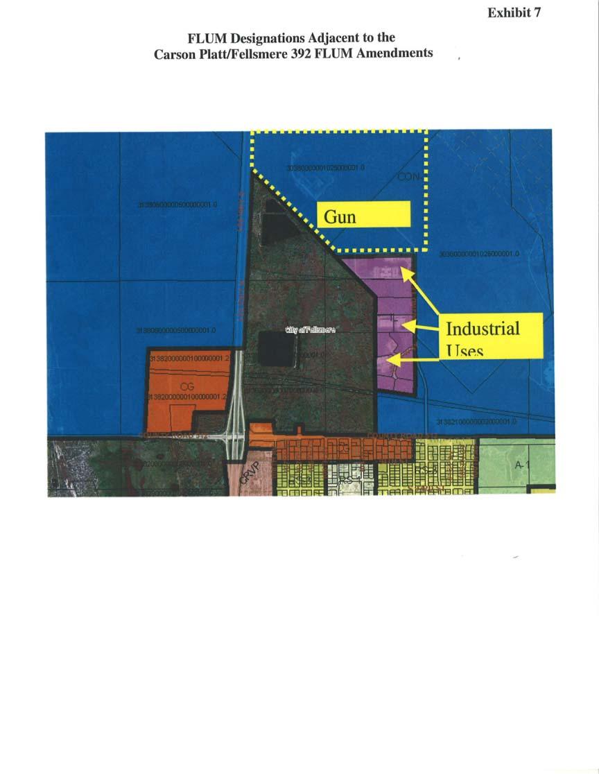
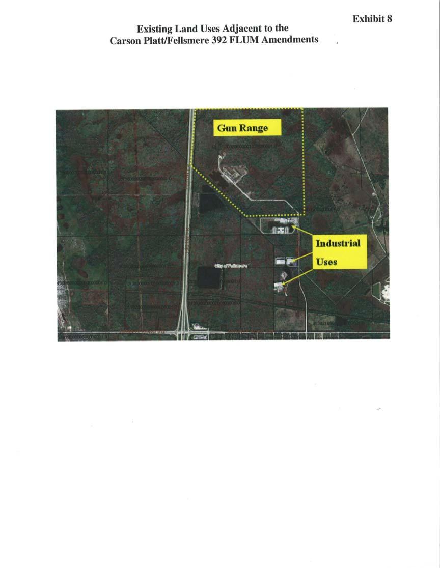
6 Extrajurisdictional Impacts According to the City correspondence dated March 6, 2007, the County was provided with a copy of the proposed amendments. In a memo dated March 20, 2007, the Treasure Coast Regional Planning Council requested comments on the proposed amendments from Indian River County and the Indian River County Metropolitan Planning Organization. In a letter dated April 10, 2007 (Attachment A), Indian River County expressed a number of concerns regarding two of the FLUM amendments. Effects on Significant Regional Resources or Facilities Analysis of the proposed amendments indicates that they are not likely to have adverse effects on significant regional resources or facilities. It is important that the native habitat on the Carson Platt/Fellsmere 392 FLUM amendment be preserved and protected. Analysis of Consistency with Strategic Regional Policy Plan (CPA-01-07) Carson Platt/ Fellsmere The proposed amendment package indicates that 174 acres of this 392 acre property will remain undeveloped as a buffer for probable eventual inclusion into the St. Sebastian Buffer Preserve. In accordance with Objective FLUE B of the Fellsmere Comprehensive Plan, the protection of conservation resources should be achieved through a FLUM designation of Conservation. Policy FLUE B-1 requires Conservation lands to be governed by regulatory agencies (SJRWMD, US Fish and Wildlife Service, FDEP or other state or federal agencies). In the event that the transfer of governance to one of these agencies is not practical, the policy allows the use of conservation easements, which shall be treated the same as areas designated Conservation on the FLUM. The applicant has negotiated on-site and off-site mitigation with SJRWMD. It is unclear why the referenced property is not being assigned a Conservation designation at this time. The City should revise the proposed amendment to assign a Conservation designation to the referenced property; consistent with City policy and with Regional Goal 2.1 of the Strategic Regional Policy Plan (SRPP). Alternatively, a conservation easement should be a condition of the FLUM amendment, consistent with Policy of the SRPP. 2. According to Chapter 163 of the Florida Statutes and contract agreement between the DCA and the Treasure Coast Regional Planning Council, one of the most important roles played by the regional planning council in reviewing proposed local government comprehensive plan amendments is to identify extrajurisdictional impacts which would be inconsistent with the comprehensive plan of an affected local government. The attached letter from Indian River County dated April 10, 2007, raises a number of concerns about the compatibility of this proposed amendment with the Indian River County Comprehensive Plan. The County indicates that the portion of the property to be redesignated for residential use (351 acres to be designated as LDMXN) is not 6
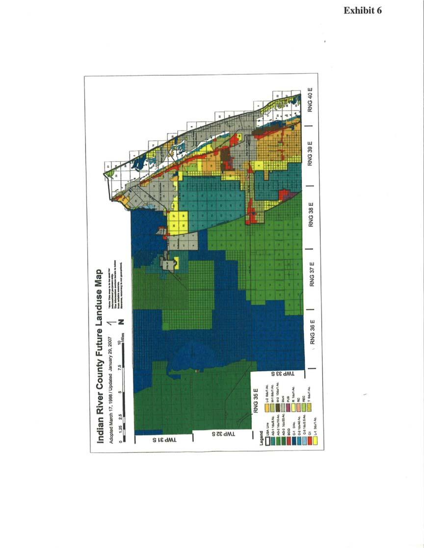
7 appropriate for such uses; and is in conflict with a number of policies in the County Comprehensive Plan. The County points out the potential incompatibility of residential uses with the adjacent County Gun Range, with existing industrial uses and with other lands designated for future industrial uses (see Exhibits 6, 7, and 8). In Goal 6.1 of the SRPP, a balanced and well-planned compatible mix of land uses is encouraged for new neighborhoods and communities. However, the incompatibility of new residential uses with existing uses that create noise, light, odor, heavy traffic, etc. should not be overlooked. Prior to the adoption of this amendment, the City should address the concerns raised by the County and indicate how the proposed new uses will be compatible with the existing uses. 3. When a municipality undertakes a sizeable annexation of unincorporated land and proposes to assign different Future Land Use Map designations to the property, a conflict between the vision as set forth in the County comprehensive plan and the new vision perceived by the municipality is likely. The City of Fellsmere has recently undertaken some large annexations and has proposed and/or adopted new FLUM designations that could significantly change the land use mix and intensity of development in those areas. Before annexing additional lands and before adopting the proposed amendments to the Carson Platt/Fellsmere 392 property, it is recommended that the City work with the County to prepare a joint annexation and future growth plan for the area. Such a plan should address such matters as land use designation and compatibility, services, schools and the designation of conservation lands. One approach would be to identify a joint planning area as authorized and encouraged in the Florida Statutes. (CP C) Banack Family Partnership 4. This 90.5 acre property currently has access from one improved road (Willow Street) and from three unimproved dirt roads. The City required a traffic analysis, which indicated that improvements to Willow Street are needed. The annexation agreement requires the owner/developer to provide various improvements including paved access to the development from 99 th Street and paved extensions of Broadway to Community Street and Community Street to 101 st Street. The agreement also stipulates that additional right-of-way needs must meet both City and County specifications. Indian River County has indicated a concern regarding transportation access to this parcel. The County is currently maintaining the unpaved roads. Multiple access points and an interconnected street network are necessary to ensuring a healthy transportation network in the region consistent with Regional Strategy Pursuant to City Policy FLUE B-1.3, new development should include the integration of both the larger streets identified in the agreement, as well as the existing finer grain neighborhood streets. The new street network should connect through the Patel Properties parcel, extending the existing street network from the south side of South Carolina Avenue. The City should also coordinate with the County to ensure the 7
8 concerns raised regarding the jurisdictional responsibility of these streets are resolved before development occurs. (CPA-01-07B) Patel Properties 5. This 20 acre parcel is located on the north side of South Carolina Avenue. In order to achieve a development form consistent with the character envisioned for the Old Town District and with Policy FLUE B-1.3, the City should require new development to extend the fine grain system of neighborhood streets on the south side of South Carolina Avenue and connect into the Banack parcel. Future Land Use Element Text Amendments 1. Principle #4 in the guiding principles of the Fellsmere Comprehensive Plan is amended to include new text stating, Lands annexed after January 2007 shall be limited to an average gross density of 3 dwelling units per acre. This provision is repeated in Policy FLUE B-2.6(3) and Policy FLUE B-13, both related to the Low Density Mixed Use Neighborhoods future land use category. This statement raises concerns regarding internal conflicts within the City s plan, establishes unnecessary limitations on future development/redevelopment and could create potential compatibility conflicts, depending upon the specific location of the annexed parcel. City Policy FLUE A-1.3 states that the highest residential densities should be allocated to areas with access to major thoroughfares, considering adjacent existing densities. The larger concern is that a policy requiring low density residential development for all future lands in the City will result in the propagation of sprawl in the region. Proposed Policy FLUE B-2.6 contains minimum criteria for the LDMXN, including the limitation of 3 du/ac for parcels annexed in the future. Regional Goal 6.1 in the SRPP encourages development in the form of sustainable neighborhoods. The SRPP describes neighborhoods as having the following elements: 1) acres in size; 2) An average gross density of 4 to 10 units per acre within a variety of building types; 3) A mix of uses; 4) A Center; 5) Civic sites; 6) Public Open Spaces; 7) Streets for people, bicycles, buses and cars; 8) Many separate and distinct buildings. The provision limiting the residential density of all future neighborhoods and communities in annexed areas to 3 dwelling units per acre is inconsistent with the SRPP. 8
9 It would prevent the development of sustainable cities, towns or villages consistent with Regional Goal 4.1, and would be inconsistent with a number of policies in Regional Goals 6.1 regarding the creation of new neighborhoods and communities and Regional Goal 15.1 regarding the containment of suburban sprawl. The City should amend the minimum principles for the LDMXN contained in Policy FLUE B-2.6 to ensure that all new master planned neighborhoods achieve the minimum standards set forth by the SRPP. Specifically, the phrase, to the extent practicable should be removed from sections (5) regarding providing conservation/ open spaces; (8) regarding providing a mix of housing types; and (9) regarding clustering residential development to provide undeveloped open space adjacent to conservation areas. Section (4) regarding an internal transportation system should be expanded to be consistent with the street network requirements in FLUE B-1.3. Policy B should be amended to require a minimum amount of institutional/recreational uses within these neighborhoods. 2. Existing Objective FLUE B-1 states that existing and new residential neighborhoods are the life blood of the community and has supporting Policy FLUE B-1.3 outlining general development standards for such residential neighborhoods. Proposed Objective FLUE-A-11 regarding Master Planned Communities should be coordinated with Policy FLUE B-1.3 so that it is clear that residential master planned communities must also meet these general development standards. The County should add a policy under Objective FLUE-A-11 (similar to Policy FLUE A-3.1 for infill projects) stipulating that the general development standards for neighborhoods also apply to master planned communities. Consistency with Strategic Regional Policy Plan The contract agreement between the DCA and the Treasure Coast Regional Planning Council requires Council to include a determination of consistency with the SRPP as part of the written report to be submitted to the DCA. Council finds the proposed amendments to be CONSISTENT with the SRPP, with the exception of: 1) the proposed text amendments to the Future Land Use Element regarding the limitation of residential density to 3 dwelling units per acre; 2) the provisions of the LDMXN future land use map category that are in conflict with the SRPP; and 3) the assignment of the LDMXN designation to 392 acres of the Carson/Platt Fellsmere 392 FLUM amendment. Recommendation Council should adopt the above comments and approve their transmittal to the Department of Community Affairs. Attachments 9
10 10
11 11
12 12
13 13
14 14
15 15
16 16
17 17
18 18
19 19
20 20
21 21
22 22
23 23
TREASURE COAST REGIONAL PLANNING COUNCIL M E M O R A N D U M. February 19, 2010 Regional Planning Council Meeting
 TREASURE COAST REGIONAL PLANNING COUNCIL M E M O R A N D U M To: Council Members AGENDA ITEM 5G From: Date: Subject: Staff February 19, 2010 Regional Planning Council Meeting Local Government Comprehensive
TREASURE COAST REGIONAL PLANNING COUNCIL M E M O R A N D U M
 TREASURE COAST REGIONAL PLANNING COUNCIL M E M O R A N D U M To: Council Members AGENDA ITEM 6A From: Date: Subject: Staff May 20, 2011 Council Meeting Local Government Comprehensive Plan Review Draft
TREASURE COAST REGIONAL PLANNING COUNCIL M E M O R A N D U M. To: Regional Planning Council Members AGENDA ITEM 5J
 TREASURE COAST REGIONAL PLANNING COUNCIL M E M O R A N D U M To: Regional Planning Council Members AGENDA ITEM 5J From: Date: Subject: Staff June 19, 2009 Regional Planning Council Meeting Local Government
TREASURE COAST REGIONAL PLANNING COUNCIL M E M O R A N D U M
 TREASURE COAST REGIONAL PLANNING COUNCIL M E M O R A N D U M To: Council Members AGENDA ITEM 5F From: Date: Subject: Staff July 16, 2010 Council Meeting Local Government Comprehensive Plan Review Draft
TREASURE COAST REGIONAL PLANNING COUNCIL M E M O R A N D U M. To: Council Members AGENDA ITEM 5M
 TREASURE COAST REGIONAL PLANNING COUNCIL M E M O R A N D U M To: Council Members AGENDA ITEM 5M From: Date: Subject: Staff December 12, 2008 Council Meeting Local Government Comprehensive Plan Review Draft
TREASURE COAST REGIONAL PLANNING COUNCIL M E M O R A N D U M. To: Council Members AGENDA ITEM 4G
 TREASURE COAST REGIONAL PLANNING COUNCIL M E M O R A N D U M To: Council Members AGENDA ITEM 4G From: Date: Subject: Staff March 16, 2007 Council Meeting Local Government Comprehensive Plan Review Draft
DRAFT Subject to Modifications
 TREASURE COAST REGIONAL PLANNING COUNCIL M E M O R A N D U M DRAFT Subject to Modifications To: Council Members AGENDA ITEM 5L From: Date: Subject: Staff September 17, 2010 Council Meeting Local Government
TREASURE COAST REGIONAL PLANNING COUNCIL M E M O R A N D U M. To: Council Members AGENDA ITEM 4E
 TREASURE COAST REGIONAL PLANNING COUNCIL M E M O R A N D U M To: Council Members AGENDA ITEM 4E From: Date: Subject: Staff October 19, 2007 Council Meeting Local Government Comprehensive Plan Review Draft
TREASURE COAST REGIONAL PLANNING COUNCIL M E M O R A N D U M. To: Council Members AGENDA ITEM 4B16
 TREASURE COAST REGIONAL PLANNING COUNCIL M E M O R A N D U M To: Council Members AGENDA ITEM 4B16 From: Date: Subject: Staff May 18, 2018 Council Meeting Local Government Comprehensive Plan Review Draft
TREASURE COAST REGIONAL PLANNING COUNCIL M E M O R A N D U M. To: Council Members AGENDA ITEM 4F
 TREASURE COAST REGIONAL PLANNING COUNCIL M E M O R A N D U M To: Council Members AGENDA ITEM 4F From: Date: Subject: Staff September 21, 2007 Council Meeting Local Government Comprehensive Plan Review
TREASURE COAST REGIONAL PLANNING COUNCIL M E M O R A N D U M. To: Regional Planning Council Members AGENDA ITEM 5D
 TREASURE COAST REGIONAL PLANNING COUNCIL M E M O R A N D U M To: Regional Planning Council Members AGENDA ITEM 5D From: Date: Subject: Staff March 20, 2009 Regional Planning Council Meeting Local Government
TREASURE COAST REGIONAL PLANNING COUNCIL M E M O R A N D U M. To: Regional Planning Council Members AGENDA ITEM 5M
 TREASURE COAST REGIONAL PLANNING COUNCIL M E M O R A N D U M To: Regional Planning Council Members AGENDA ITEM 5M From: Date: Subject: Staff June 19, 2009 Regional Planning Council Meeting Local Government
INDIAN RIVER COUNTY, FLORIDA. The Honorable Members of the Planning and Zoning Commission DEPARTMENT HEAD CONCURRENCE
 Public Hearing Legislative INDIAN RIVER COUNTY, FLORIDA M E M O R A N D U M TO: The Honorable Members of the Planning and Zoning Commission DEPARTMENT HEAD CONCURRENCE Robert M. Keating, AICP; Community
TREASURE COAST REGIONAL PLANNING COUNCIL M E M O R A N D U M. To: Council Members AGENDA ITEM 4F
 TREASURE COAST REGIONAL PLANNING COUNCIL M E M O R A N D U M To: Council Members AGENDA ITEM 4F From: Date: Subject: Staff January 18, 2008 Council Meeting Local Government Comprehensive Plan Review Draft
TREASURE COAST REGIONAL PLANNING COUNCIL M E M O R A N D U M. To: Council Members AGENDA ITEM 7C4
 TREASURE COAST REGIONAL PLANNING COUNCIL M E M O R A N D U M To: Council Members AGENDA ITEM 7C4 From: Date: Subject: Staff October 21, 2016 Council Meeting Local Government Comprehensive Plan Review Draft
MEMORANDUM AGENDA ITEM #6b
 South Florida Regional Planning Council MEMORANDUM AGENDA ITEM #6b DATE: SEPTEMBER 13, 2010 TO: FROM: COUNCIL MEMBERS STAFF SUBJECT: ISLAMORADA, VILLAGE OF ISLANDS, PROPOSED COMPREHENSIVE PLAN AMENDMENT
DRAFT Subject to Modifications
 DRAFT Subject to Modifications TREASURE COAST REGIONAL PLANNING COUNCIL M E M O R A N D U M To: Council Members AGENDA ITEM 8C From: Date: Subject: Staff April 18, 2014 Council Meeting Local Government
TREASURE COAST REGIONAL PLANNING COUNCIL M E M O R A N D U M. To: Council Members AGENDA ITEM 9D
 TREASURE COAST REGIONAL PLANNING COUNCIL M E M O R A N D U M To: Council Members AGENDA ITEM 9D From: Date: Subject: Staff May 15, 2015 Council Meeting Local Government Comprehensive Plan Review Draft
Marion County Board of County Commissioners
 Marion County Board of County Commissioners Date: 6/4/217 P&Z: 9/25/217 BCC Transmittal: 1/17/217 BCC Adopt: TBD Amendment No: 217-L6 Type of Application Large-Scale Comp Plan Amendment Request: Change
TREASURE COAST REGIONAL PLANNING COUNCIL M E M O R A N D U M. To: Council Members AGENDA ITEM 8N
 TREASURE COAST REGIONAL PLANNING COUNCIL M E M O R A N D U M To: Council Members AGENDA ITEM 8N From: Date: Subject: Staff September 18, 2015 Council Meeting Local Government Comprehensive Plan Review
13 Sectional Map Amendment
 13 Sectional Map Amendment Introduction This chapter reviews land use and zoning policies and practices in Prince George s County and presents the proposed zoning in the sectional map amendment (SMA) to
SOUTHWEST FLORIDA REGIONAL PLANNING COUNCIL LOCAL GOVERNMENT COMPREHENSIVE PLAN REVIEW FORM 01 DATE AMENDMENT MAILED TO LOCAL GOVERNMENT AND STATE:
 Attachment II SOUTHWEST FLORIDA REGIONAL PLANNING COUNCIL LOCAL GOVERNMENT COMPREHENSIVE PLAN REVIEW FORM 01 LOCAL GOVERMENT: Sarasota County DATE AMENDMENT RECIEVED: November 27, 2013 DATE AMENDMENT MAILED
CHAPTER Committee Substitute for Committee Substitute for Senate Bill No. 2188
 CHAPTER 2004-372 Committee Substitute for Committee Substitute for Senate Bill No. 2188 An act relating to land development; amending s. 197.502, F.S.; providing for the issuance of an escheatment tax
SUBJECT: ISLAMORADA, VILLAGE OF ISLANDS, PROPOSED COMPREHENSIVE PLAN AMENDMENT
 South Florida Regional Planning Council MEMORANDUM AGENDA ITEM #6c DATE: SEPTEMBER 14, 2009 TO: FROM: COUNCIL MEMBERS STAFF SUBJECT: ISLAMORADA, VILLAGE OF ISLANDS, PROPOSED COMPREHENSIVE PLAN AMENDMENT
MEMORANDUM AGENDA ITEM #IV.C
 MEMORANDUM AGENDA ITEM #IV.C DATE: JANUARY 28, 2019 TO: FROM: COUNCIL MEMBERS STAFF SUBJECT: LOCAL GOVERNMENT COMPREHENSIVE PLAN PROPOSED AND ADOPTED AMENDMENT CONSENT AGENDA Pursuant to the 1974 Interlocal
EVALUATION AND APPRAISAL REPORT OF THE CITY OF FELLSMERE COMPREHENSIVE PLAN APPENDIX D HOUSING ELEMENT
 OBJECTIVE H-A-1: ALLOW AFFORDABLE HOUSING AND ADEQUATE SITES FOR VERY LOW, LOW, AND MODERATE INCOME HOUSING. The City projects the total need for very low, low, and moderate income-housing units for the
4.2 LAND USE INTRODUCTION
 4.2 LAND USE INTRODUCTION This section of the EIR addresses potential impacts from the Fresno County General Plan Update on land use in two general areas: land use compatibility and plan consistency. Under
TREASURE COAST REGIONAL PLANNING COUNCIL M E M O R A N D U M. To: Council Members AGENDA ITEM 8P
 TREASURE COAST REGIONAL PLANNING COUNCIL M E M O R A N D U M To: Council Members AGENDA ITEM 8P From: Date: Subject: Staff March 20, 2015 Council Meeting Local Government Comprehensive Plan Review Draft
LAKE NONA PARCEL 10 & 11
 October 17, 2017 Staff Report to the Municipal Planning Board CASE #DRI2017-10003 GMP2017-10012 GMP2017-10013 ZON2017-10005 Item #2 LAKE NONA PARCEL 10 & 11 Location Map Subject Site SUMMARY Owner James
Marion County Board of County Commissioners
 Marion County Board of County Commissioners Date: 12/29/2015 P&Z: 12/28/2015 BCC: 1/12/2016 Item Number 160113Z Type of Application Rezoning Request From: A-1 (General Agriculture) To: PUD (Planned Unit
MEMORANDUM! AGENDA ITEM #IV.C
 MEMORANDUM AGENDA ITEM #IV.C DATE: DECEMBER 07, 2018 TO: FROM: COUNCIL MEMBERS STAFF SUBJECT: LOCAL GOVERNMENT COMPREHENSIVE PLAN PROPOSED AND ADOPTED AMENDMENT CONSENT AGENDA Pursuant to the 1974 Interlocal
CHAPTER 2 VACANT AND REDEVELOPABLE LAND INVENTORY
 CHAPTER 2 VACANT AND REDEVELOPABLE LAND INVENTORY CHAPTER 2: VACANT AND REDEVELOPABLE LAND INVENTORY INTRODUCTION One of the initial tasks of the Regional Land Use Study was to evaluate whether there is
Kitsap County Department of Community Development
 Kitsap County Department of Community Development Staff Report and Recommendation Annual Comprehensive Plan Amendment Process for 2018 George s Corner LAMIRD Boundary Adjustment Report Date 7/16/2018 Hearing
Land Use Planning Analysis. Phase 2 Drayton Valley Annexation Proposal
 Land Use Planning Analysis Phase 2 Drayton Valley Annexation Proposal Prepared for Town of Drayton Valley Prepared by Mackenzie Associates Consulting Group Limited March, 2011 TABLE OF CONTENTS 1.0 INTRODUCTION...
Walworth County Farmland Preservation Plan Update, Chapter 1 Plan Summary (Cover Document)
") Background Walworth County Farmland Preservation Plan Update, 2012 Chapter 1 Plan Summary (Cover Document) For over 30-years, the Wisconsin Farmland Preservation Program has served to preserve Walworth
Background Walworth County Farmland Preservation Plan Update, 2012 Chapter 1 Plan Summary (Cover Document) For over 30-years, the Wisconsin Farmland Preservation Program has served to preserve Walworth
METROPOLITAN COUNCIL 390 North Robert Street, St. Paul, MN Phone (651) TDD (651)
 TDD (651)") METROPOLITAN COUNCIL 390 North Robert Street, St. Paul, MN 55101 Phone (651) 602-1000 TDD (651) 291-0904 DATE: April 27, 2011 TO: Metropolitan Parks and Open Space Commission FROM: Arne Stefferud, Planning
METROPOLITAN COUNCIL 390 North Robert Street, St. Paul, MN 55101 Phone (651) 602-1000 TDD (651) 291-0904 DATE: April 27, 2011 TO: Metropolitan Parks and Open Space Commission FROM: Arne Stefferud, Planning
EXHIBIT A. City of Corpus Christi Annexation Guidelines
 City of Corpus Christi Annexation Guidelines Purpose: The purpose of this document is to describe the City of Corpus Christi s Annexation Guidelines. The Annexation Guidelines provide the guidance and
Executive Summary Land Use 4-A
 Executive Summary Land Use 4-A The Land Use Element looks at how land is currently being used in Blaine, and evaluates the need for new development based on the predicted number of new residents and businesses
CITY OF ST. PETERSBURG DCA#11-2ESR
 Agenda Item #3.H.7 08/08/11 TAMPA BAY REGIONAL PLANNING COUNCIL LOCAL GOVERNMENT COMPREHENSIVE PLAN PROPOSED AMENDMENT REPORT CITY OF ST. PETERSBURG DCA#11-2ESR For Council meeting of August 8, 2011 1
REPORT OF THE PLANNING AND DEVELOPMENT DEPARTMENT FOR APPLICATION FOR REZONING ORDINANCE TO PLANNED UNIT DEVELOPMENT MAY 8, 2014
 BEL REPORT OF THE PLANNING AND DEVELOPMENT DEPARTMENT FOR APPLICATION FOR REZONING ORDINANCE TO PLANNED UNIT DEVELOPMENT MAY 8, 2014 The Planning and Development Department hereby forwards to the Planning
Board of County Commissioners Agenda Request
 Board of County Commissioners Agenda Request Date of Meeting: March 26, 2019 Date Submitted: March 19, 2019 To: From: Agenda Location: Subject: Honorable Chairman and Members of the Board Margaret Emblidge,
 PROJECT NARRATIVE AVENIR PCD MISCELLANEOUS AMENDMENT November 27, 2018 Urban Planning and Design Landscape Architecture Communication Graphics Request Avenir Development, LLC and Avenir Holdings, LLC,
PALM BEACH COUNTY PLANNING, ZONING AND BUILDING DEPARTMENT ZONING DIVISION
 PALM BEACH COUNTY PLANNING, ZONING AND BUILDING DEPARTMENT ZONING DIVISION Application No.: Z-2016-00663 Application Name: Autism School Control No.: 2014-00133 Applicant: Dayna2, LLC Owners: Dayna2, LLC
HENDRY COUNTY PLANNING & ZONING DEPARTMENT POST OFFICE BOX S. MAIN STREET LABELLE, FLORIDA (863) FAX: (863)
 FAX: (863)") HENDRY COUNTY PLANNING & ZONING DEPARTMENT POST OFFICE BOX 2340 640 S. MAIN STREET LABELLE, FLORIDA 33975 (863) 675-5240 FAX: (863) 674-4194 STAFF REPORT CPA19-0001 Comprehensive Plan Map Amendment Local
HENDRY COUNTY PLANNING & ZONING DEPARTMENT POST OFFICE BOX 2340 640 S. MAIN STREET LABELLE, FLORIDA 33975 (863) 675-5240 FAX: (863) 674-4194 STAFF REPORT CPA19-0001 Comprehensive Plan Map Amendment Local
ATTACHMENT #1 SUMMARY CHART
 ATTACHMENT #1 SUMMARY CHART Item # Amendment To: Nature of Proposed Amendment PCM201801 PCM201802 PCM201803 PCM201804 LMA201802 LMA201803 LMA201804 PCT201801 PCT201802 PCT201803 FUTURE LAND USE MAP Parkway
Village WASHINGTON TOWNSHIP MASTER PLAN SYNTHESIS. Page 197
 Village P l a n WASHINGTON TOWNSHIP MASTER PLAN SYNTHESIS Page 197 SECTION 11.0 MASTER PLAN SYNTHESIS INTRODUCTION The proposals presented in the various plans result in a graphic synthesis: The Land Use
CASE # LUP Commission District: # 3
 CASE # LUP-15-02-038 Commission District: # 3 GENERAL INFORMATION APPLICANT OWNER PROJECT NAME HEARING TYPE REQUEST Richard Frucci Lingo Lane, LLC Lingo Lane Planned Development / Land Use Plan (PD/LUP)
Dennis & Donna Blanchard, Agent. Dennis & Donna Blanchard/Disbrow Builders, Inc.
 Nassau County Growth Management Department 96161 Nassau Place Yulee, FL 32097 (904) 491-7328 (904) 491-3611 FAX Date of Hearing: March 3, 2015 BOARD MEMBERS Thomas Ford (Chairman) Gene Bennett John Stack
ORDINANCE NO L02, D. Wormser/L.R. Roberts/Et. Al Page 1 of 9 Adoption Ordinance
 ORDINANCE NO. 17- AN ORDINANCE OF THE BOARD OF COUNTY COMMISSIONERS OF MARION COUNTY, FLORIDA; ADOPTING THE FOLLOWING LARGE-SCALE AMENDMENT TO THE FUTURE LAND USE MAP SERIES AND TEXT OF THE MARION COUNTY
LARGE- AND SMALL-SCALE COMPREHENSIVE PLAN AMENDMENT INSTRUCTIONS AND INFORMATION PACKET
 LARGE- AND SMALL-SCALE COMPREHENSIVE PLAN AMENDMENT INSTRUCTIONS AND INFORMATION PACKET MARION COUNTY GROWTH SERVICES 2710 E. Silver Springs Blvd. Ocala, FL 34470 Phone 352-438-2600 Fax 352-438-2601 http://www.marioncountyfl.org/planning.htm
STAFF REPORT City of Ormond Beach Department of Planning
 STAFF REPORT City of Ormond Beach Department of Planning DATE: February 5, 2014 SUBJECT: 875 Sterthaus Drive, Ormond Renaissance Condominium, Comprehensive Plan Amendment over ten acres APPLICANT: Parker
Town of Cary, North Carolina Rezoning Staff Report 12-REZ-27 Morris Branch Town Council Public Hearing January 24, 2013
 Town of Cary, North Carolina Rezoning Staff Report 12-REZ-27 Morris Branch Town Council Public Hearing January 24, 2013 REQUEST To amend the Town of Cary Official Zoning Map to rezone approximately 9.0
STAFF REPORT. Permit Number: Laurier Enterprises, Inc. Kitsap County Board of Commissioners; Kitsap County Planning Commission
 STAFF REPORT Permit Number: 15 00740 Laurier Enterprises, Inc. DATE: December 18, 2015 TO: FROM: Kitsap County Board of Commissioners; Kitsap County Planning Commission Katrina Knutson, AICP, Senior Planner,
Planning Commission Staff Report October 6, 2011
 Planning Commission Staff Report October 6, 2011 Project: Laguna Ridge Phase 3 Subdivision Projects McGeary Ranch, Arbor Ranch, Zgraggen Ranch & Tuscan Ridge Files: EG-10-059 (McGeary Ranch), EG-10-060
Cover Letter with Narrative Statement
 Cover Letter with Narrative Statement March 31, 2017 rev July 27, 2017 RE: Rushton Pointe Residential Planned Unit Development Application for Public Hearing for RPUD Rezone PL2015 000 0306 Mr. Eric Johnson,
Corporate Report. 2. That the Interim Control By-law prohibit within the Low Density Residential Suburban Neighbourhood (R1) zone, the following:
 zone, the following:") Corporate Report Report from Planning and Building Services, Planning Services Date of Report: November 23,2016 Date of Meeting: December 5, 2016 Report Number: PBS-330-2016 File: 60.35.2.1 Subject: Interim
Corporate Report Report from Planning and Building Services, Planning Services Date of Report: November 23,2016 Date of Meeting: December 5, 2016 Report Number: PBS-330-2016 File: 60.35.2.1 Subject: Interim
THE REDEVELOPMENT PLAN
 PAGE 37 THE REDEVELOPMENT PLAN FUTURE LAND USE The Silver Terrace Redevelopment Area is currently designated as Redevelopment Area #4 on the City of Delray Beach Future Land Use Map (FLUM). This designation
b. providing adequate sites for new residential development
 DIVISION 2.200 SECTION 2.201 INTRODUCTION A. Purpose The purpose of the Housing Element is to establish the goal, objectives, and policies to guide housing development within Polk County over the next
GENERAL PLAN UPDATE. Joint Study Session March 29, 2017
 GENERAL PLAN UPDATE Joint Study Session March 29, 2017 Interrelated Issues and Topics Property Owner Requests Mobility: Efficiency and Safety Land Use Plan (in the City) Light Rail/ Transit Jobs/ Housing
HOUSING ELEMENT GOALS, OBJECTIVES, AND POLICIES
 HOUSING ELEMENT GOALS, OBJECTIVES, AND POLICIES GOAL 1: To promote the preservation and development of high-quality, balanced, and diverse housing options for persons of all income levels throughout the
Land Development Code Update Workgroup AGENDA
 Land Development Code Update Workgroup AGENDA Thursday, September 27, 2012 2:00 PM 4:00 PM Pinellas County Strategic Planning & Initiatives 310 Court Street, Clearwater, Florida 33756 ~ (727) 464-8200
BOARD OF COUNTY COMMISSIONERS DATE: October 8, 2013 AGENDA ITEM NO. 20v-C,
 BOARD OF COUNTY COMMISSIONERS DATE: October 8, 2013 AGENDA ITEM NO. 20v-C, Consent Agenda D Regular Agenda D Public Hearing ~ County Administrator's Signature".\~ Vf7 ~,_,v Subject: Proposed Regular Amendments
Annutteliga Hammock Project Surplus and Consolidation Strategy
 Project Overview Annutteliga Hammock is a 31,250-acre partnership acquisition project of the Florida Forever program, of which 12,231 acres have been acquired to date. The intent of the project is to provide
Glades County Staff Report and Recommendation REZONING
 Glades County Staff Report and Recommendation REZONING CASE NUMBER: RZ15-01 DATE: October 2, 2015 CASE TYPE: Application for Rezoning REQUEST: J.J. Wiggins Memorial Trust is requesting a rezoning of 22.1±
Central Lathrop Specific Plan
 Addendum to the Draft Environmental Impact Report for the Central Lathrop Specific Plan SCH# 2003072132 Prepared for City of Lathrop Prepared by December 2005 Addendum to the Draft Environmental Impact
LAND USE ELEMENT CITY OF HAWTHORNE GENERAL PLAN
 LAND USE ELEMENT CITY OF HAWTHORNE GENERAL PLAN Adopted April, 1990 Last amended March, 2016 Prepared by: Cotton/Beland/Associates, Inc. 1028 North Lake Avenue, Suite 107 Pasadena, California 91104 TABLE
STAFF REPORT. Permit Number: Laurier Enterprises, Inc. Kitsap County Board of Commissioners; Kitsap County Planning Commission
 STAFF REPORT Permit Number: 15 00740 Laurier Enterprises, Inc. DATE: November 9, 2015 TO: FROM: Kitsap County Board of Commissioners; Kitsap County Planning Commission Katrina Knutson, AICP, Senior Planner,
Implementation. Approved Master Plan and SMA for Henson Creek-South Potomac 103
 Implementation Approved Master Plan and SMA for Henson Creek-South Potomac 103 104 Approved Master Plan and SMA for Henson Creek-South Potomac Sectional Map Amendment The land use recommendations in the
Land Use. Existing Land Use
 8 Land Use 8.1 Land Use Chapter Purpose and Contents This element includes a brief summary of existing land use conditions and trends followed by a series of goals, objectives, and recommendations to guide
CITY OF NORTH LAS VEGAS MEMORANDUM
 CITY OF NORTH LAS VEGAS MEMORANDUM TO: FROM: SUBJECT: Planning Commission Community Development and Compliance Department # 28 ) AMP-03-15; Coleman Airpark II & III - Comprehensive Plan Amendment (Public
REPORT OF THE PLANNING AND DEVELOPMENT DEPARTMENT FOR APPLICATION FOR REZONING ORDINANCE TO PLANNED UNIT DEVELOPMENT APRIL 21, 2016
 BEL REPORT OF THE PLANNING AND DEVELOPMENT DEPARTMENT FOR APPLICATION FOR REZONING ORDINANCE TO PLANNED UNIT DEVELOPMENT APRIL 21, 2016 The Planning and Development Department hereby forwards to the Planning
HOUSING ELEMENT GOALS, OBJECTIVES, & POLICIES
 HOUSING ELEMENT GOALS, OBJECTIVES, & POLICIES GOAL H-1: ENSURE THE PROVISION OF SAFE, AFFORDABLE, AND ADEQUATE HOUSING FOR ALL CURRENT AND FUTURE RESIDENTS OF WALTON COUNTY. Objective H-1.1: Develop a
Urban Mixed Use (UMU) Zoning District
 Zoning District") Urban Mixed Use (UMU) Zoning District Prepared by the City of Titusville Community Development Department Contents Purpose... 3 Background... 3 History of the Urban Mixed Use Zoning Classification... 4
Urban Mixed Use (UMU) Zoning District Prepared by the City of Titusville Community Development Department Contents Purpose... 3 Background... 3 History of the Urban Mixed Use Zoning Classification... 4
City of South Miami Comprehensive Plan
 City of South Miami Comprehensive Plan The City Commission of the City of South Miami, Florida adopted the Comprehensive Plan on January 18, 1989 for submittal to the Florida Department of Community Affairs
42-Acre Parcel Rezoning and Master Plan Amendment. Danny Cagle and Patrick Stanley 6301 Duckweed Rd. Lake Worth, FL 33449
 STAFF REPORT CITY OF PARKLAND DEVELOPMENT SERVICES DEPARTMENT Date Prepared: May 2, 2014 I. Petition Description Petition No.: Project Name: Owners: RZ14-001; MPA14-002 42-Acre Parcel Rezoning and Master
CITRUS COUNTY COMPREHENSIVE PLAN
 CITRUS COUNTY COMPREHENSIVE PLAN APPENDIX F METHODOLOGIES USED IN THE FUTURE LAND USE ELEMENT REFERENCED IN CHAPTER 10 FUTURE LAND USE Updated: December 2, 1997, Ord. No. 1997-A29 This page left intentionally
DESCRIPTION OF THE DISTRICT
 DESCRIPTION OF THE DISTRICT The project plan for City of Wausau, Tax Increment District #11 has been prepared in compliance with Wisconsin Statutes Chapter 66.1105(4). The plan establishes the need for
Comment: the Plan endeavors to conserve resources that can nurture additional development. What kind of resources, environmental, capital, or etc.?
 Memorandum TO: Peggy Fiandaca and Curt Dunham, Partners for Strategic Action Inc. FROM: Jessica Sarkissian, CMX DATE: September 4, 2008 SUBJECT: Proposed 2008 Draft Comprehensive Plan Comments This memo
Chapter 6 Future Land Use and Housing Plan
 Chapter 6 Future Land Use and Housing Plan The Future Land Use Plan is one of the most important elements of the Comprehensive Plan. It graphically brings together all of the chapters of the plan and evaluates
CITY OF PORT ORCHARD
 CITY OF PORT ORCHARD ZONING DESIGNATIONS (Adapted from POMC Chapter 20.34 Zoning Districts, as adopted 6/13/2017) 20.34.110 Greenbelt zone (Gb). (1) Purpose. It is the purpose of the greenbelt zone to
Pierce County Comprehensive Plan Review
 2015-2016 Pierce County Comprehensive Plan Review March 16, 2016 Introduction Planning and Management Policies Some of the policies governing both the planning and management of growth and change within
FUTURE LAND USE. City of St. Augustine Comprehensive Plan EAR-Based Amendments
 FUTURE LAND USE City of St. Augustine Comprehensive Plan EAR-Based Amendments Future Land Use Element FLU Goal To create an environment within the City and adjacent areas in which its residents have the
CITY PLANNING COMMISSION AGENDA ITEM NOS: B.1-B.3 STAFF: MEGGAN HERINGTON
 Page 17 CITY PLANNING COMMISSION AGENDA ITEM NOS: B.1-B.3 STAFF: MEGGAN HERINGTON FILE NO(S): CPC MP 87-00381-A13MN14 QUASI-JUDICIAL CPC PUZ 14-00101 QUASI-JUDICIAL CPC PUP 05-00139-A1MJ14 QUASI-JUDICIAL
GOALS, OBJECTIVES, AND STRATEGIES
 GOALS, OBJECTIVES, AND STRATEGIES What follows is a series of goals, recommendations and actions that reflect the themes outlined in the Mineral Springs Vision Plan (incorporated into this document as
Town of. River Falls. Land Use Element Vierbicher Associates, Inc
 Town of River Falls 2005 Vierbicher Associates, Inc Contents Contents s. 66.1001(2)(h) Wis. Stats................................................. ii Introduction................................................................
Master Plan Review WESTBARD
 Master Plan Review WESTBARD Approved and Adopted 1982 Westbard Page 1 of 15 Updated July 2014 based on Adopted DMA ONING CODE REWRITE BACKGROUND In 2007, the Montgomery County Council directed the Planning
Plans shall be drawn at a readable scale, signed, and sealed by a Florida Registered Engineer. The application package shall include:
 CHAPTER 400. SECTION 403. PERMIT TYPES AND APPLICATIONS SITE DEVELOPMENT 403.3. Preliminary Site Plans (PSP) A. Intent and Purpose PSPs are used to identify existing site conditions and demonstrate general
City of Brandon Brownfield Strategy
 City of Brandon Brownfield Strategy 2017 Executive Summary A brownfield is a property, the expansion, redevelopment, or reuse of which may be complicated by the presence or potential presence of a hazardous
AWH REPORT OF THE PLANNING AND DEVELOPMENT DEPARTMENT FOR APPLICATION FOR REZONING ORDINANCE MAY 7, 2015
 AWH REPORT OF THE PLANNING AND DEVELOPMENT DEPARTMENT FOR APPLICATION FOR REZONING ORDINANCE 2015-0243 MAY 7, 2015 The Planning and Development Department hereby forwards to the Planning Commission, Land
Town of Cary, North Carolina Rezoning Staff Report 14-REZ-24 Indian Wells Road Properties Town Council Meeting November 20, 2014
 Town of Cary, North Carolina Rezoning Staff Report 14-REZ-24 Indian Wells Road Properties Town Council Meeting November 20, 2014 REQUEST To amend the Town of Cary Official Zoning Map by revising a condition
2030 General Plan. December 6, 7 pm
 2030 General Plan GPAC Meeting #9 GPAC Meeting #9 December 6, 7 pm City Council Input on Working Draft Land Use Map Council discussed GPAC & PC versions of the working draft land use map 11/28 Council
891941, , : COMPREHENSIVE PLAN AMENDMENT, COMMUNITY PLAN AMENDMENT, AND AREA-WIDE MAP AMENDMENT
 Application Nos. 891941, 891909, 891940: COMPREHENSIVE PLAN AMENDMENT, COMMUNITY PLAN AMENDMENT, AND AREA-WIDE MAP AMENDMENT Amendments to designate five parcels as Rural Industrial Center in the Alderton
STAFF REPORT. Permit Number: Porter. Kitsap County Board of Commissioners; Kitsap County Planning Commission
 STAFF REPORT Permit Number: 15 00461 Porter DATE: November 9, 2015 TO: FROM: Kitsap County Board of Commissioners; Kitsap County Planning Commission Katrina Knutson, AICP, Senior Planner, DCD and Jeff
Lake Pickett North Project / University Area Community District
 Overview: Justification Statement for Lake Pickett North Project / University Area Community District In the last decade several attempts have been made to analyze areas within East Orange County east
HOUSING ELEMENT OF THE CITY OF PEMBROKE PINES COMPREHENSIVE PLAN ADOPTION DOCUMENT
 HOUSING ELEMENT OF THE CITY OF PEMBROKE PINES COMPREHENSIVE PLAN RULES 9J-5.010, FAC City of Pembroke Pines, Florida ADOPTION DOCUMENT HOUSING ELEMENT HOUSING ELEMENT ADOPTION DOCUMENT VI. GOALS, OBJECTIVES
HOUSING ELEMENT I. GOALS, OBJECTIVES AND POLICIES
 HOUSING ELEMENT I. GOALS, OBJECTIVES AND POLICIES GOAL 1: IN ORDER TO ACHIEVE A BALANCED HOUSING SUPPLY (AND A BALANCED POPULATION AND ECONOMIC BASE), EVERY EFFORT SHOULD BE MADE TO PROVIDE A BROAD RANGE
Staff Report for Council Public Meeting
 Agenda Item 3.3 Staff Report for Council Public Meeting Date of Meeting: September 27, 2017 Report Number: SRPRS.17.134 Department: Division: Subject: Planning and Regulatory Services Development Planning
LAND USE. General Plan Update Working Paper January In this Working Paper. Page
 General Plan Update Working Paper January 2008 In this Working Paper Page Introduction... LU-1 Distribution of Existing Land Uses... LU-1 Current General Plan Designations... LU-5 Westover Field Airport
Dennis & Donna Blanchard, Agent. Dennis & Donna Blanchard/Disbrow Builders, Inc.
 Nassau County Growth Management Department 96161 Nassau Place Yulee, FL 32097 (904) 491-7328 (904) 491-3611 FAX Date of Hearing: March 3, 2015 Public Hearing Number: R15-001 BOARD MEMBERS Thomas Ford (Chairman)
GENERAL DESCRIPTION STAFF RECOMMENDATION IMPLEMENTATION REQUIREMENTS
 Application No.: 891418 Applicant: AREA-WIDE MAP AMENDMENT Rezone two parcels from Moderate Density Single Family (MSF) to Neighborhood Center (NC) and Employment Center (EC). Charles Bitton GENERAL DESCRIPTION