Annutteliga Hammock Project Surplus and Consolidation Strategy
|
|
|
- Verity Shields
- 5 years ago
- Views:
Transcription
1
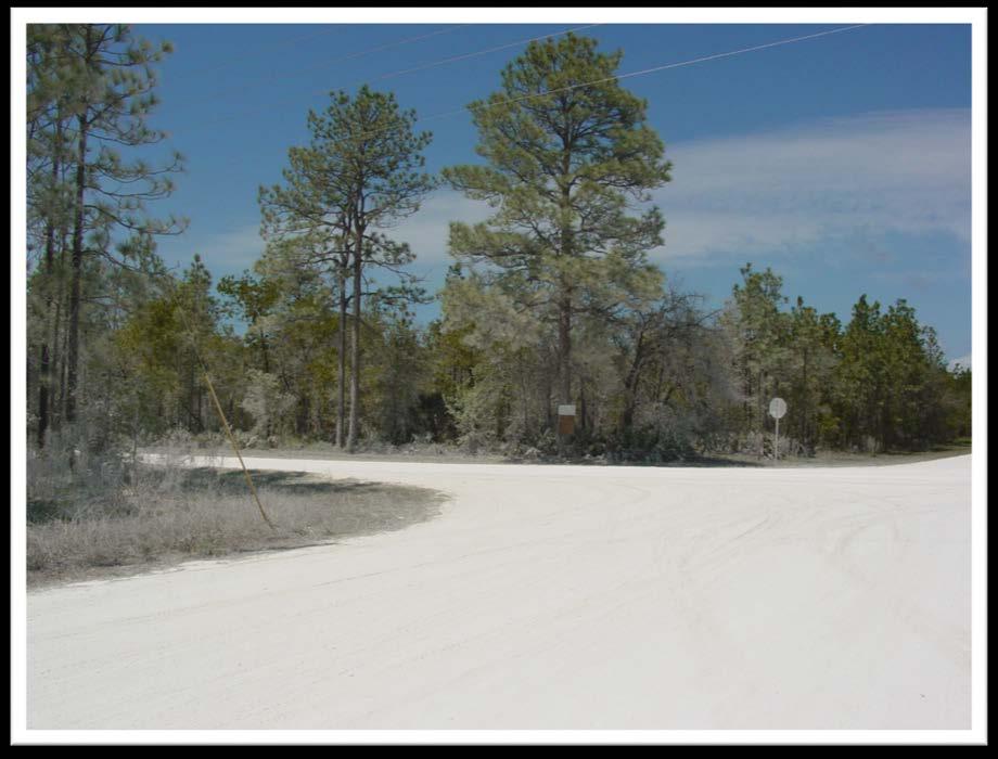
2 Project Overview Annutteliga Hammock is a 31,250-acre partnership acquisition project of the Florida Forever program, of which 12,231 acres have been acquired to date. The intent of the project is to provide for water quality protection of Chassahowitzka Springs and serve as a natural linkage between the Chassahowitzka Wildlife Management Area and Withlacoochee State Forest. With the Florida Department of Environmental Protection (FDEP) as the lead agency, other acquisition partners include the Southwest Florida Water Management District (District), Hernando County, Florida Forest Service (FFS), Florida Department of Transportation (FDOT), Florida Fish and Wildlife Conservation Commission (FWC) and The Nature Conservancy. The District s acquisition area includes 8,489 acres, with 2,317 acres acquired to date. The majority of this area includes Royal Highlands, a platted subdivision consisting of half-acre to one-acre lots. The area is characterized by a lack of central water or wastewater services and contains an extensive network of unpaved, County-maintained roads. Acquisition Challenges Beginning in 98, the District acquired 2,164 acres in the project area. By 2005, significant real estate price escalation and concerns with managing the scattered nature of the project resulted in a temporary halt on acquisition. Approval of a smaller acquisition area allowed for continuation in This area provided for connectivity with adjacent public lands and generally corresponds to the Consolidation Regions identified on Exhibit 2. The revised approach allowed staff to proceed directly to the Governing Board with appraisals and acquisition for parcels not exceeding appraised value. An additional 153 acres were acquired until further acquisition ceased in Management Challenges Effective long-term management of the project is increasingly difficult. Prescribed fire management of the small, non-contiguous parcels is precluded due to the immediate adjacency of private properties or structures. Security to discourage illegal dumping or unauthorized uses is labor and time intensive. Current land management activities focus on larger project tracts and consist of security, prescribed burning, resource monitoring, exotic species control, and public use/recreational development and monitoring. Changes by FDEP to the Florida Forever project boundary in 2011 eliminated properties with residential or commercial structures, mining or intensive agricultural operations, or those previously developed with infrastructure (i.e., water/sewer lines, paved roads). This removed 802 parcels (1,073 acres) from the District s project acquisition area and 2,970 parcels (3,667 acres) outside the area, reducing potential for meaningful connectivity with partner project lands to the south and east.
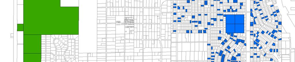
3 Strategy Recommendations Identify parcels for surplus and retention Exhibit 1 depicts those properties within the Annutteliga Hammock project proposed for surplus, as well as those proposed for retention. Surplus activities for the identified parcels, to the extent practicable, should be undertaken in a prioritized phasing based on market and infrastructure considerations, as follows: Phase 1 - Parcels adjacent to roads proposed for paving by Hernando County in Royal Highlands Units 6, 7 and 8 (Exhibit 3) Phase 2 Parcels in Country Estates and Florida Sunshine Farmettes and Royal Highlands Units 1B, 3, and 3B, which exhibit greater sales activity and/or are located in closer proximity to U.S. Highway and community services (i.e., shopping, medical, etc.) Phase 3 Remaining parcels located within Royal Highlands Units 6, 7 and 8 Define areas for consolidation - The Consolidation Region depicted on Exhibit 2 provides for connectivity with public conservation properties to the west and north. Acquisitions within this corridor may be considered in a prioritized manner once initial surplus efforts prove successful and could occur via purchase or in exchange (on an equal value basis) with other District-owned surplus parcels. Initial acquisitions, if pursued, should be emphasized within Priority Area 1 to consolidate that portion of the project located between existing public conservation lands. Acquisitions within Priority Areas 2 and 3 may be pursued, in that order, but are secondary to those within Priority Area 1. Combine parcels for surplus to reduce impacts and competition with other property sales In an effort to reduce nitrogen loading within the Chassahowitzka springshed, contiguous District-owned parcels identified for surplus should be combined, where feasible and practicable, and sold or traded as one property. This would result in up to 587 smaller individual parcels being combined into up to 210 larger parcels (Exhibit 4). The combined parcels would be deed restricted (or other viable instrument) to one dwelling unit and the development envelope limited, thereby reducing potential septic and landscape nitrogen loading within the springshed. Combining parcels for surplus will result in creating a unique product, allowing for increased sales potential by those seeking a larger or atypical property within this geographic area. The unique nature of this product also serves to reduce direct sales competition with the numerous half-acre properties typical of this area. Special provisions for larger surplus properties In order to afford enhanced water resources protection, additional provisions will be implemented as a condition of sale for those larger properties (20+ acres and greater) identified as surplus. Provisions may include, but are not limited to: 1) restrictions on the number of times each parcel can be subdivided to limit density; and/or 2) use of conservation easements, deed restrictions or other measures to limit the development envelope and uses on each parcel. The subject properties are located within either the Rural and Residential land use categories on the Hernando County Future Land Use Map (FLUM), with 2
4 two of the properties containing existing FLUM designations of Conservation. Zoning for the properties include either Agriculture or Residential (R1C). Pursuant to the Hernando County Comprehensive Plan, properties in the Rural category have an allowed density of up to 1 dwelling unit per 10 acres, whereas the properties in the Residential category are allowed up to 5.4 dwelling units per acre. Any proposed subdivision of these properties would be restricted to densities allowed by the FLUM, but will be limited by the District to a maximum of 1 dwelling unit per 10 acres, generally affording greater protections than the overlying FLUM designations. Coordination with partner acquisition entities Given the partnership nature of the project, continue coordination activities with each of the identified project acquisition partners, including the FDEP, FFS, FWC, FDOT, Hernando County and The Nature Conservancy. Ongoing coordination with Hernando County is recommended relative to their engagement with citizens on District surplus activities, their long-range road paving initiatives and the proposed extension of Thrasher Road through to U.S. Highway 98. Coordination with Hernando County on land use activities Several measures outlined in this strategy to address continued resource protection will require activities that are land use based in nature. These measures include, but are not limited to, use of plat vacations, replatting and/or rezoning for property consolidation, as well as use of deed restrictions or conservation easements to limit densities and/or development envelopes. Given Hernando County s specific authority for land use control, application of these measures will require close coordination with the County. As such, the District has initiated discussions with the County s Planning and Zoning staff for review and input on these options and will continue to coordinate with them to implement those measures most effective to achieving the objectives of this strategy. Coordination with Public Affairs Bureau on strategy implementation The nature and extent of the proposed surplus effort warrants coordination with Public Affairs Bureau staff. They can assist in the development of messaging and other outreach that may be required for this unique, long-term surplus/consolidation project. Initiate surplus activities Pursuant to direction outlined in this strategy, initiate disposition activities for the identified surplus parcels. Disposition of District-owned parcels should be considered available for, in priority order: 1) exchange with privately owned parcels starting with those located in the Priority 1 Consolidation Region; 2) sale to abutting property owners; or 3) sale on the open market as surplus. Exchanges should first be explored in order to not flood the market with additional properties, which could potentially further depress property values. Provisions of Chapter (4), F.S., provide Governing Board flexibility in addressing exchanges, with all such exchanges to occur on an equal value basis. Continue to pursue changes to Chapter 373, Florida Statutes Changes to Chapter , F.S., proposed as part of SB 762 considered by the 2015 Florida Legislature did not pass. Such changes would have provided greater latitude to the District and other agencies in the disposition of smaller, lesser valued properties like 3
5 many of those within the Annutteliga Hammock project. The District will continue to pursue such changes in future years. In the interim, the District will continue to be efficient and flexible in its disposition of properties in accordance with existing Florida Statutes and District Governing Board policies and procedures, with an overall objective to fully recoup its investment in the project. 4

")
 Parcels with Houses (1,096")
 Project Boundary")

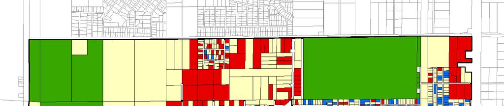
6 Exhibit 1 Annutteliga Hammock - Surplus Parcels and Parcels to be Retained Other Conservation Lands Proposed Surplus Parcels (1,021 parcels) District Owned Parcels Retained (345 parcels) Parcels with Houses (1,096 parcels) Privately Owned Vacant Parcels (4,701 parcels) Project Boundary SUNCOAST PKWY THRASHER AVE Area Not Included in Project CENTRALIA RD 0 2,000 4,000 Document Path: P:\SpecialProjects\DistLandsProfiles\MXDs\Annutteliga_Hammock\AH Status Map.mxd Feet

 Consolidation Region")

7 Exhibit 2 Annutteliga Hammock - Surplus Parcels and Consolidation Region Priority Areas Other Conservation Lands Proposed Surplus Parcels (1,021 parcels) District Owned Parcels Retained (345 parcels) Consolidation Region - Priority Area 1 Consolidation Region - Priority Area 2 Consolidation Region - Priority Area 3 SUNCOAST PKWY THRASHER AVE CENTRALIA RD 0 2,000 4,000 Document Path: P:\SpecialProjects\DistLandsProfiles\MXDs\Annutteliga_Hammock\AH Status Map.mxd Feet
8 Exhibit 3 Annutteliga Hammock - Proposed Paving Areas Other Conservation Lands Proposed Surplus Parcels (1,021 parcels) District Owned Parcels Retained (345 parcels) Consolidation Region - Priority Area 1 Consolidation Region - Priority Area 2 Consolidation Region - Priority Area 3 Roads Proposed to be Paved SUNCOAST PKWY THRASHER AVE CENTRALIA RD 0 2,000 4,000 Document Path: P:\SpecialProjects\DistLandsProfiles\MXDs\Annutteliga_Hammock\AH Status Map.mxd Feet

9 Exhibit 4 Annutteliga Hammock - Proposed Merged Parcels Other Conservation Lands District Owned Parcels Retained (345 parcels) Parcels proposed to be merged Parcels proposed not to be merged SUNCOAST PKWY THRASHER AVE CENTRALIA RD 0 2,000 4,000 Document Path: P:\SpecialProjects\DistLandsProfiles\MXDs\Annutteliga_Hammock\AH Status Map.mxd Feet
CHAPTER Committee Substitute for Committee Substitute for Senate Bill No. 2188
 CHAPTER 2004-372 Committee Substitute for Committee Substitute for Senate Bill No. 2188 An act relating to land development; amending s. 197.502, F.S.; providing for the issuance of an escheatment tax
1. Future Land Use FLU6.6.8 Land uses within the Rural Service Area portion of the Wekiva Study Area shall be limited to very low and low intensity
 1. Future Land Use FLU6.6.8 Land uses within the Rural Service Area portion of the Wekiva Study Area shall be limited to very low and low intensity uses to the greatest extent possible. Existing land uses
TREASURE COAST REGIONAL PLANNING COUNCIL M E M O R A N D U M
 TREASURE COAST REGIONAL PLANNING COUNCIL M E M O R A N D U M To: Council Members AGENDA ITEM 6A From: Date: Subject: Staff May 20, 2011 Council Meeting Local Government Comprehensive Plan Review Draft
NANTUCKET ISLANDS LAND BANK AFFORDABLE HOUSING POLICY Adopted by the vote of the Land Bank Commission on November 10, 2015
 NANTUCKET ISLANDS LAND BANK AFFORDABLE HOUSING POLICY Adopted by the vote of the Land Bank Commission on November 10, 2015 In recent history, the island of Nantucket has experienced a shortage of affordable,
FINAL DRAFT 12/1/16, Rev. to 7/18/17
 FINAL DRAFT 12/1/16, Rev. to 7/18/17 (As Adopted 8/8/17 Effective 9/1/17) SHELTON PLANNING AND ZONING COMMISSION Proposed Amendments to Zoning Regulations I. Amend Section 23 PERMITTED USES by inserting
Land Acquisition - Florida Forever Mid-Term Review
 Land Acquisition - Florida Forever Mid-Term Review Report Number 2006-120 November 2005 Prepared for The Florida Senate Prepared by Committee on Environmental Preservation Table of Contents Summary 1 Background
Submittal of the Minutes from the March 9, 2011, April 5, 2011, and April 19, 2011 Cabinet Meetings.
 AGENDA BOARD OF TRUSTEES OF THE INTERNAL IMPROVEMENT TRUST FUND JUNE 16, 2011 Attachments to the items below can be viewed at the following link: http://www.dep.state.fl.us/secretary/cab/public_notices.htm
Conservation Design Subdivisions
 Conservation Design Subdivisions An excerpt from the Rules and Regulations Governing Division of Land in Sheridan County, Wyoming, November 5, 2010 Sheridan County Public Works Department 224 S. Main Street
CITY OF PENSACOLA AFFORDABLE HOUSING INCENTIVE PLAN
 1. BACKGROUND CITY OF PENSACOLA AFFORDABLE HOUSING INCENTIVE PLAN The Sadowski Affordable Housing Act as approved by the Florida Legislature and codified as Chapter 420 of the Florida Statutes requires
Marion County Board of County Commissioners
 Marion County Board of County Commissioners Date: 6/4/217 P&Z: 9/25/217 BCC Transmittal: 1/17/217 BCC Adopt: TBD Amendment No: 217-L6 Type of Application Large-Scale Comp Plan Amendment Request: Change
PROPOSED FINDINGS OF FACT BENDER URBAN GROWTH BOUNDARY EXPANSION AND ANNEXATION REQUEST April 3, Background
 PROPOSED FINDINGS OF FACT BENDER URBAN GROWTH BOUNDARY EXPANSION AND ANNEXATION REQUEST April 3, 2016 Background The owners of TL300, 301, 302, 303, and 304, 3N1027BD - properties abutting the City Limits
SUBJECT: ISLAMORADA, VILLAGE OF ISLANDS, PROPOSED COMPREHENSIVE PLAN AMENDMENT
 South Florida Regional Planning Council MEMORANDUM AGENDA ITEM #6c DATE: SEPTEMBER 14, 2009 TO: FROM: COUNCIL MEMBERS STAFF SUBJECT: ISLAMORADA, VILLAGE OF ISLANDS, PROPOSED COMPREHENSIVE PLAN AMENDMENT
Marion County Board of County Commissioners
 Marion County Board of County Commissioners Date: 12/29/2015 P&Z: 12/28/2015 BCC: 1/12/2016 Item Number 160113Z Type of Application Rezoning Request From: A-1 (General Agriculture) To: PUD (Planned Unit
Walton County Planning and Development Services
 Walton County Planning and Development Services 31 Coastal Centre Boulevard, Suite 100 47 N 6 th Street Santa Rosa Beach, Florida 32459 DeFuniak Springs, Florida 32433 Phone 850-267-1955 Phone 850-892-8157
CHAPTER 2 VACANT AND REDEVELOPABLE LAND INVENTORY
 CHAPTER 2 VACANT AND REDEVELOPABLE LAND INVENTORY CHAPTER 2: VACANT AND REDEVELOPABLE LAND INVENTORY INTRODUCTION One of the initial tasks of the Regional Land Use Study was to evaluate whether there is
TREASURE COAST REGIONAL PLANNING COUNCIL M E M O R A N D U M. To: Council Members AGENDA ITEM 10A
 TREASURE COAST REGIONAL PLANNING COUNCIL M E M O R A N D U M To: Council Members AGENDA ITEM 10A From: Date: Subject: Staff April 20, 2007 Council Meeting Local Government Comprehensive Plan Review Draft
CITY OF TARPON SPRINGS Staff Report May 16, 2017
 CITY OF TARPON SPRINGS Staff Report May 16, 2017 TO: FROM: HEARING DATES: SUBJECT: MAYOR & BOARD OF COMMISSIONERS PLANNING & ZONING DEPARTMENT MAY 15, 2017 (PLANNING & ZONING BOARD) JUNE 6, 2017 (BOC 1
Report to the Plan Commission December 19, 2011
 Report to the Plan Commission Legistar I.D. #24825, Extraterritorial Certified Survey Map Requested Action: Consideration of a two-lot Certified Survey Map (CSM) of the Keryluk-Wee property located at,,
Town of Yucca Valley GENERAL PLAN 1
 Town of Yucca Valley GENERAL PLAN 1 This page intentionally left blank. 3 HOUSING ELEMENT The Housing Element is intended to guide residential development and preservation consistent with the overall values
Reading Plats and the Complexities of Antiquated Subdivisions Presented by: David W. Depew, PhD, AICP, LEED AP Morris-Depew Associates, Inc.
 Presented by: David W. Depew, PhD, AICP, LEED AP Morris-Depew Associates, Inc. Introduction Plat is a term for a survey of a piece of land to identify boundaries, easements, flood zones, roadway, and access
HHLT Educational Forum: Conservation Subdivisions and the Open Space Overlay. February 5th 2018 Winter Hill
 HHLT Educational Forum: Conservation Subdivisions and the Open Space Overlay February 5th 2018 Winter Hill 1 Topics Covered SECTION I II III IV V TOPIC Comprehensive Plan Open Space Index Conservation
TOWN OF MIDDLEBOROUGH COMMUNITY PRESERVATION PLAN
 TOWN OF MIDDLEBOROUGH COMMUNITY PRESERVATION PLAN Vision The residents of Middleborough desire a community which is family-oriented and which retains its small town character while preserving an abundance
SHIP Affordable Housing Advisory Committee
 SHIP Affordable Housing Advisory Committee October 28, 2015 Webinar sponsored by Florida Housing Finance Corporation Catalyst Program Presenters Michael Chaney, Florida Housing Coalition Caleena Shirley,
EXHIBIT A. City of Corpus Christi Annexation Guidelines
 City of Corpus Christi Annexation Guidelines Purpose: The purpose of this document is to describe the City of Corpus Christi s Annexation Guidelines. The Annexation Guidelines provide the guidance and
THE REDEVELOPMENT PLAN
 PAGE 37 THE REDEVELOPMENT PLAN FUTURE LAND USE The Silver Terrace Redevelopment Area is currently designated as Redevelopment Area #4 on the City of Delray Beach Future Land Use Map (FLUM). This designation
General Development Plan Background Report on Agricultural Land Preservation
 General Development Plan 2008 Background Report on Agricultural Land Preservation February 2008 I. Introduction Anne Arundel County has been an agricultural community for over 350 years, beginning with
Chapter SWAINSON S HAWK IMPACT MITIGATION FEES
 The Swainson s Hawk ordinance can also be viewed online at: http://qcode.us/codes/sacramentocounty/ Once at the website, click on Title 16 BUILDINGS AND CONSTRUCTION, then Chapter 16.130 SWAINSON S HAWK
ORDINANCE NO AN ORDINANCE AMENDING THE CODE OF ORDINANCES OF THE CITY OF PORT ARANSAS, TEXAS, BY ADOPTING A NEW CHAPTER
 ORDINANCE NO. 2008-09 AN ORDINANCE AMENDING THE CODE OF ORDINANCES OF THE CITY OF PORT ARANSAS, TEXAS, BY ADOPTING A NEW CHAPTER TWENTY-SIX CONCERNING IMPACT FEES FOR ROADWAY FACILITIES; INCORPORATING
Business Item Community Development Committee Item:
 Business Item Community Development Committee Item: 2008-124 C Meeting date: July 21, 2008 ADVISORY INFORMATION Date: May 21, 2008 Subject: Flexible Residential Development Ordinance Guidelines District(s),
Conservation Collier Red Maple Swamp Preserve
 Preserve Extended Interim Management Plan First Extension Prepared By: Collier County s Conservation Collier Program Parks & Recreation Department 15000 Livingston Road Naples, FL 34109 May 2013 G:\CDES
Central Pennsylvania Conservancy Project Selection Criteria Form
 Central Pennsylvania Conservancy Project Selection Criteria Form The following criteria guide the actions of the Central Pennsylvania Conservancy s Land Protection Committee and Board of Directors in selecting
CCC XXX Rural Neighborhood Conservation (NC)
") CCC 33.10.XXX Rural Neighborhood Conservation (NC) Purpose: Maintain low density rural residential areas and associated uses commonly found in rural areas consistent with the local character of the distinctive
CCC 33.10.XXX Rural Neighborhood Conservation (NC) Purpose: Maintain low density rural residential areas and associated uses commonly found in rural areas consistent with the local character of the distinctive
How to Adopt an Affordable Housing Advisory Committee (AHAC) Report
 Report") How to Adopt an Affordable Housing Advisory Committee (AHAC) Report sponsored by Florida Housing Finance Corporation Catalyst Program Presenters Michael Chaney, Florida Housing Coalition Caleena Shirley,
How to Adopt an Affordable Housing Advisory Committee (AHAC) Report sponsored by Florida Housing Finance Corporation Catalyst Program Presenters Michael Chaney, Florida Housing Coalition Caleena Shirley,
Moorhead,, Minnesota
 City of Moorhead Moorhead,, Minnesota Stonemill Estates Redevelopment Plan May 2013 City of Moorhead 500 Center Avenue Moorhead, MN 56561 www.cityofmoorhead.com Stonemill Estates Redevelopment Plan 1 INTRODUCTION
Mohave County General Plan
 63 64 65 66 67 68 69 70 71 The Land Use Diagram is not the County's zoning map. 13 It is a guide to future land use patterns. Zoning and area plan designations may be more restrictive than the land use
Amendment 1 Sponsor Committee Water and Land Conservation Amendment (850)
") ! Amendment 1 Text Amendment 1 Sponsor Committee Water and Land Conservation Amendment (850) 629-4656 emailus@floridawaterlandlegacy.org www.floridawaterlandlegacy.org TITLE: Water and Land Conservation
! Amendment 1 Text Amendment 1 Sponsor Committee Water and Land Conservation Amendment (850) 629-4656 emailus@floridawaterlandlegacy.org www.floridawaterlandlegacy.org TITLE: Water and Land Conservation
Application Training / Overview Questions and Answers July 10, 2018
 Application Training / Overview Questions and Answers July 10, 2018 1. Does community outreach of 500 feet need to be done before the application submittal? A. The City encourages that community outreach,
Implementation TOWN OF LEON COMPREHENSIVE PLAN 9-1
 9 Implementation 9.1 Implementation Chapter Purpose and Contents This element includes a compilation of regulatory and non-regulatory measures to implement the objectives of this comprehensive plan. The
A. Preserve natural resources as identified in the Comprehensive Plan.
 1370.08 Conservation Residential Overlay District. Subd. 1 Findings. The City finds that the lands and resources within the Conservation Residential Overlay District are a unique and valuable resource
Planning Justification Report
 Planning Justification Report, Township of Puslinch FARHI HOLDINGS CORPORATION Updated January 27, 2017 Zelinka Priamo Ltd. Page i TABLE OF CONTENTS Page No. 1.0 1.1 1.2 1.3 2.0 2.1 2.2 2.3 2.4 2.5 3.0
Land Use Planning Analysis. Phase 2 Drayton Valley Annexation Proposal
 Land Use Planning Analysis Phase 2 Drayton Valley Annexation Proposal Prepared for Town of Drayton Valley Prepared by Mackenzie Associates Consulting Group Limited March, 2011 TABLE OF CONTENTS 1.0 INTRODUCTION...
REPORT OF THE PLANNING AND DEVELOPMENT DEPARTMENT FOR APPLICATION FOR REZONING ORDINANCE TO PLANNED UNIT DEVELOPMENT MAY 18, 2017
 BEL REPORT OF THE PLANNING AND DEVELOPMENT DEPARTMENT FOR APPLICATION FOR REZONING ORDINANCE 2016-805 TO PLANNED UNIT DEVELOPMENT MAY 18, 2017 The Planning and Development Department hereby forwards to
b. providing adequate sites for new residential development
 DIVISION 2.200 SECTION 2.201 INTRODUCTION A. Purpose The purpose of the Housing Element is to establish the goal, objectives, and policies to guide housing development within Polk County over the next
HOUSING ELEMENT GOALS, OBJECTIVES, & POLICIES
 HOUSING ELEMENT GOALS, OBJECTIVES, & POLICIES GOAL H-1: ENSURE THE PROVISION OF SAFE, AFFORDABLE, AND ADEQUATE HOUSING FOR ALL CURRENT AND FUTURE RESIDENTS OF WALTON COUNTY. Objective H-1.1: Develop a
Pierce County Comprehensive Plan Review
 2015-2016 Pierce County Comprehensive Plan Review March 16, 2016 Introduction Planning and Management Policies Some of the policies governing both the planning and management of growth and change within
Chapter XX Purchase of Development Rights Program
 Chapter XX Purchase of Development Rights Program Short Title. This ordinance is to be known and may be cited as the Purchase of Development Rights ( PDR ) Program. Purpose Pursuant to the authority granted
CONCURRENCY MANAGEMENT SYSTEM ELEMENT
 CONCURRENCY MANAGEMENT SYSTEM ELEMENT TOWN OF HOWEY-IN-THE-HILLS LAKE COUNTY, FLORIDA ADOPTED ON OCTOBER 11, 2010 CONCURRENCY MANAGEMENT SYSTEM ELEMENT TABLE OF CONTENTS A. OVERVIEW OF THE CONCURRENCY
Submittal of the Minutes from the April 28, 2009 and June 9, 2009 Cabinet Meetings.
 AGENDA BOARD OF TRUSTEES DEPARTMENT OF AGRICULTURE & CONSUMER SERVICES JULY 28, 2009 Attachments to the items below can be viewed at the following link: http://www.fl-dof.com/calendar/public_notices.html
THE MARYLAND-NATIONAL CAPITAL PARK AND PLANNING COMMISSION PRINCE GEORGE'S COUNTY PLANNING BOARD STAFF REPORT
 THE MARYLAND-NATIONAL CAPITAL PARK AND PLANNING COMMISSION PRINCE GEORGE'S COUNTY PLANNING BOARD STAFF REPORT SUBJECT Implementation of the Sustainable Growth and Agricultural Preservation Act of 2012
A. Land Use Relationships
 Chapter 9 Land Use Plan A. Land Use Relationships Development patterns in Colleyville have evolved from basic agricultural and residential land uses, predominate during the early stages of Colleyville
Instructions: Script:
 Before the course, select four of the 11 tool topics to insert into the presentation, including at least one tool from each of the three goal categories. Replace each tool placeholder slide with the slides
****************************************************************************** Item 1 Minutes
 AGENDA BOARD OF TRUSTEES OF THE INTERNAL IMPROVEMENT TRUST FUND APRIL 14, 2015 Attachments to the items below can be viewed at the following link: http://www.dep.state.fl.us/secretary/cab/public_notices.htm
Transfer of Development Rights
 Ordinance Transfer of Development Rights King County s (WA) 2008 ordinance establishes a transfer of development rights program. The ordinance: Sets eligibility criteria for sending and receiving sites
INTRODUCTION Future Land Use Element
 EXHIBIT A INTRODUCTION Future Land Use Element The purpose of the Future Land Use Element is to examine the existing land uses and to determine present and future land use needs such as the amount of land
Town of Prairie du Sac Sauk County, WI. Land Division Ordinance 07-3
 Town of Prairie du Sac Sauk County, WI Land Division Ordinance 07-3 1.01 DISCLAIMER (1) Multiple Jurisdictions. All persons reviewing the provisions of this Ordinance should be aware that the Town of Prairie
TRANSFER OF DEVELOPMENT RIGHTS
 STEPS IN ESTABLISHING A TDR PROGRAM Adopting TDR legislation is but one small piece of the effort required to put an effective TDR program in place. The success of a TDR program depends ultimately on the
Land Use. Existing Land Use
 8 Land Use 8.1 Land Use Chapter Purpose and Contents This element includes a brief summary of existing land use conditions and trends followed by a series of goals, objectives, and recommendations to guide
Florida Housing Finance Corporation Qualified Allocation Plan Low Income Housing Tax Credits Program
 Florida Housing Finance Corporation 2016 2017 Qualified Allocation Plan Low Income Housing Tax Credits Program I. Introduction Pursuant to Section 420.5099, Florida Statutes, the Florida Housing Finance
INDIAN RIVER COUNTY, FLORIDA. The Honorable Members of the Planning and Zoning Commission DEPARTMENT HEAD CONCURRENCE
 Public Hearing Legislative INDIAN RIVER COUNTY, FLORIDA M E M O R A N D U M TO: The Honorable Members of the Planning and Zoning Commission DEPARTMENT HEAD CONCURRENCE Robert M. Keating, AICP; Community
4. facilitate the construction of streets, utilities and public services in a more economical and efficient manner;
 PVPC MODEL BYLAW BY-RIGHT CLUSTER ZONING BYLAW Prepared by Pioneer Valley Planning Commission Revised: October 2001 1.00 Development 1.01 Development Allowed By Right Development in accordance with this
DRAFT FOR PUBLIC HEARING (rev. March, 2016)
") Chapter 200. ZONING Article VI. Conservation/Cluster Subdivisions 200-45. Intent and Purpose These provisions are intended to: A. Guide the future growth and development of the community consistent with
Chapter 200. ZONING Article VI. Conservation/Cluster Subdivisions 200-45. Intent and Purpose These provisions are intended to: A. Guide the future growth and development of the community consistent with
Burlington Unincorporated Community Plan
 Burlington Unincorporated Community Plan June 30, 2010 Meeting Page 1 of 24 Table of Contents (Page numbers to be inserted) I. Background a. Location and Community Description b. Planning of Unincorporated
Title 6 - Local Government Provisions Applicable to Special Purpose Districts and Other Political Subdivisions
 Title 6 - Local Government Provisions Applicable to Special Purpose Districts and Other Political Subdivisions CHAPTER 29. SOUTH CAROLINA LOCAL GOVERNMENT COMPREHENSIVE PLANNING ENABLING ACT OF 1994 1994
HOUSING ELEMENT OF THE CITY OF PEMBROKE PINES COMPREHENSIVE PLAN ADOPTION DOCUMENT
 HOUSING ELEMENT OF THE CITY OF PEMBROKE PINES COMPREHENSIVE PLAN RULES 9J-5.010, FAC City of Pembroke Pines, Florida ADOPTION DOCUMENT HOUSING ELEMENT HOUSING ELEMENT ADOPTION DOCUMENT VI. GOALS, OBJECTIVES
City of Sanibel. Planning Department STAFF REPORT
 City of Sanibel Planning Department STAFF REPORT Planning Commission Meeting: July 23, 2013 Planning Commission Agenda Item: No 7b. Application Number: 13-7438DP Applicant Name: Attorney Beverly Grady
51.08 Acres AREA INFORMATION & CONCEPTUAL SITE PLAN
 Property Details: Folio #: R22-423-18-0000-0010-0000 Zoned: PDP (Planned Development Project Industrial) Lot Size: *Seller Willing to Allow Use Change* Direct Frontage on Anderson Snow Road 1.2 miles from
AGENDA BOARD OF TRUSTEES OF THE INTERNAL IMPROVEMENT TRUST FUND MAY 13, 2009 Substitute Page
 AGENDA BOARD OF TRUSTEES OF THE INTERNAL IMPROVEMENT TRUST FUND MAY 13, 2009 Substitute Page * Substitute Item 1 Guana Tolomato Matanzas National Estuarine Research Reserve Management Plan REQUEST: Consideration
Appendix A: Guide to Zoning Categories Prince George's County, Maryland
 Appendix A: Guide to Zoning Categories Prince George's County, Maryland RESIDENTIAL ZONES 1 Updated November 2010 R-O-S: Reserved Open Space - Provides for permanent maintenance of certain areas of land
CITY OF FORT COLLINS NATURAL AREAS AND CONSERVED LANDS EASEMENT POLICY
 CITY OF FORT COLLINS NATURAL AREAS AND CONSERVED LANDS EASEMENT POLICY Adopted January 3, 2012 PURPOSE: The purpose of the policy statement is to clarify the policies and procedures of the City of Fort
For sale 47.6± acre country getaway Palm city, FL
 For sale 47.6± acre country getaway Palm city, FL 3500 SW CORPORATE PKWY, SUITE 202 PALM CITY, FL 34990 772 287-4690 - 772 287-9643 (Fax) PROPERTY INFORMATION LOCATION: 6180 SW Citrus Boulevard Palm City,
Claudia Stuart, Williamson Act Program Manager and Nick Hernandez, Planning Intern
 Land Conservation (Williamson) Act Advisory Committee STAFF REPORT September 15, 2014 Prepared by: Claudia Stuart, Williamson Act Program Manager and Nick Hernandez, Planning Intern Subject: Discussion:
FACT SHEET MUNICIPAL SERVICE BENEFIT UNIT (MSBU) CREATION AND IMPLEMENTATION
 CREATION AND IMPLEMENTATION") FACT SHEET MUNICIPAL SERVICE BENEFIT UNIT (MSBU) CREATION AND IMPLEMENTATION Authority Florida Statutes Chapter 125.01(1)(a) authorizes the Board of County Commissioners to create Municipal Service Benefit
FACT SHEET MUNICIPAL SERVICE BENEFIT UNIT (MSBU) CREATION AND IMPLEMENTATION Authority Florida Statutes Chapter 125.01(1)(a) authorizes the Board of County Commissioners to create Municipal Service Benefit
 PROJECT NARRATIVE AVENIR PCD MISCELLANEOUS AMENDMENT November 27, 2018 Urban Planning and Design Landscape Architecture Communication Graphics Request Avenir Development, LLC and Avenir Holdings, LLC,
[2015 INCENTIVE REVIEW AND RECOMMENDATION REPORT] STATE HOUSING INITIATIVES PARTNERSHIP (SHIP)
![[2015 INCENTIVE REVIEW AND RECOMMENDATION REPORT] STATE HOUSING INITIATIVES PARTNERSHIP (SHIP)](/thumbs/88/115967658.jpg "[2015 INCENTIVE REVIEW AND RECOMMENDATION REPORT] STATE HOUSING INITIATIVES PARTNERSHIP (SHIP)") 2015 BCC Collier County Affordable Housing Advisory Committee Community and Human Services Division [2015 ICETIVE REVIEW AD RECOMMEDATIO REPORT] STATE HOUSIG IITIATIVES PARTERSHIP (SHIP) DECEMBER 8, 2015
2015 BCC Collier County Affordable Housing Advisory Committee Community and Human Services Division [2015 ICETIVE REVIEW AD RECOMMEDATIO REPORT] STATE HOUSIG IITIATIVES PARTERSHIP (SHIP) DECEMBER 8, 2015
Appendix A. Definitions
 Definitions 1. Terms Defined. Words contained in this are those having a special meaning relative to the purposes of this Ordinance. Words not listed in this section shall be defined by reference to: (1)
MUNICIPAL SERVICE BENEFIT UNIT (MSBU) CREATION AND ADMINISTRATION POLICY 16-01
 CREATION AND ADMINISTRATION POLICY 16-01") MUNICIPAL SERVICE BENEFIT UNIT (MSBU) CREATION AND ADMINISTRATION POLICY 16-01 PURPOSE: POLICY: The purpose of this policy is to provide an orderly and efficient method for utilizing the statutory authority
MUNICIPAL SERVICE BENEFIT UNIT (MSBU) CREATION AND ADMINISTRATION POLICY 16-01 PURPOSE: POLICY: The purpose of this policy is to provide an orderly and efficient method for utilizing the statutory authority
June 1, 2017 BOARD MATTER H - 1 FINAL CONSIDERATION OF STATE TRUST LAND EXCHANGE
 June 1, 2017 BOARD MATTER H - 1 ACTION: AUTHORITY: FINAL CONSIDERATION OF STATE TRUST LAND EXCHANGE W.S. 36-1-107, 36-1-110, and 36-1-111; Board of Land Commissioners Rules and Regulations, Chapter 26,
PROJECT SCORING GUIDANCE. Introduction: National Proiect Selection:
 FOREST LEGACY PROGRAM PROJECT SCORING GUIDANCE Introduction: This document provides guidance to the National Review Panel on how to score individual Forest Legacy Program (FLP) projects, including additional
AMENDED DEED OF CONSERVATION EASEMENT
 Prepared by: Wayne E. Flowers Lewis, Longman & Walker, P.A. 245 Riverside Ave. Suite 150 Jacksonville, FL 32202 Return recorded original to: Mitigation Marketing 1091 W. Morse Blvd. Suite 101 Winter Park,
BLUEPRINT REAL ESTATE POLICY
 DATE September 19,2007 TITLE BLUEPRINT REAL ESTATE POLICY ORG. AGENCY Blueprint Intergovernmental Agency APPROVED.01 STATEMENT OF POLICY The purpose of this administrative regulation is to establish a
Kent Land Trust Strategic Reassessment Project Final Report
 Kent Land Trust Strategic Reassessment Project Final Report Prepared For: Connecticut Institute for Resilience and Climate Adaptation (CIRCA) Prepared by: Michael A. Benjamin, Land Steward, Kent Land Trust
Governing Board of the Southwest Florida Water Management District Staff of the Southwest Florida Water Management District
 AUDUBON OF FLORIDA - DEFENDERS OF WILDLIFE EARTHJUSTICE - FLORIDA WILDLIFE FEDERATION - GULF COAST CONSERVANCY - GULF RESTORATION NETWORK - HERNANDO AUDUBON SOCIETY - THE NATURE CONSERVANCY 03/30/2009
SECTION 1 INTRODUCTION TO THE PANAMA CITY BEACH COMPREHENSIVE GROWTH DEVELOPMENT PLAN
 1. PURPOSE SECTION 1 INTRODUCTION TO THE PANAMA CITY BEACH COMPREHENSIVE GROWTH DEVELOPMENT PLAN The purpose of the City of Panama City Beach's Comprehensive Growth Development Plan is to establish goals,
St. Mary s County Comprehensive Zoning Ordinance Article 1. GENERAL PROVISIONS
 0 0 0 0 ARTICLE. GENERAL PROVISIONS CHAPTER 0 TITLE, PURPOSE AND ORGANIZATION Sections: 0. Title. 0. Authority. 0. Purpose. 0. Organization of the Zoning Ordinance. 0. Official Zoning Map. 0. Applicability.
THE CORPORATION OF THE CITY OF WINDSOR POLICY
 THE CORPORATION OF THE CITY OF WINDSOR POLICY Service Area: Office of the City Solicitor Policy No.: Department: Legal Approval Date: February 3, 2014 Division: Real Estate Approved By: CR 30/2014 Effective
Implementation. Approved Master Plan and SMA for Henson Creek-South Potomac 103
 Implementation Approved Master Plan and SMA for Henson Creek-South Potomac 103 104 Approved Master Plan and SMA for Henson Creek-South Potomac Sectional Map Amendment The land use recommendations in the
REGENTS POLICY PART V FINANCE AND BUSINESS MANAGEMENT Chapter Real Property
 REGENTS POLICY PART V FINANCE AND BUSINESS MANAGEMENT Chapter 05.11 Real Property P05.11.010. Purpose and Scope. A. This chapter establishes guidelines for the prudent management, including trust management,
Spirit Lake North, LLC
 BONNER COUNTY PLANNING DEPARTMENT PLANNING AND ZONING COMMISSION STAFF REPORT FOR March 1, 2018 Project Name: Amendment & Zone Change: Spirit Lake North, LLC File Number,Type: AM 162-18/ZC365-18 Request:
CHAPTER Committee Substitute for Committee Substitute for House Bill No. 437
 CHAPTER 2013-83 Committee Substitute for Committee Substitute for House Bill No. 437 An act relating to community development; amending s. 159.603, F.S.; revising the definition of qualifying housing development
OPEN SPACE PRESERVATION. Reflections on the Value of Acquiring Property for Preservation Purposes
 OPEN SPACE PRESERVATION Reflections on the Value of Acquiring Property for Preservation Purposes What is open space and what does it do? The Town Plan of Conservation and Development defines it as follows:
DENTON Developer's Handbook
 DENTON Developer's Handbook A guide for land development in the City of Denton Department of Development Services 2017 2 Table of Contents 1. City of Denton Development Process...5 Role of the Development
Multiple Use Forest District (MUF)
") This district is defined as Multiple Use Forest District with a minimum lot size of 20 acres. 11.15.2162 Purposes The purposes of the Multiple Use Forest District are to conserve and encourage the use
This district is defined as Multiple Use Forest District with a minimum lot size of 20 acres. 11.15.2162 Purposes The purposes of the Multiple Use Forest District are to conserve and encourage the use
GWINNETT COUNTY CSO CONSERVATION SUBDIVISION OVERLAY DISTRICT REQUIREMENTS
 GWINNETT COUNTY CSO CONSERVATION SUBDIVISION OVERLAY DISTRICT REQUIREMENTS Section 1316. CSO Conservation Subdivision Overlay District. 1. Purposes. The purposes of this overlay district are as follows:
1 dwelling unit/existing parcel with provisions for a guest house and additional quarters
 TABLE 1.3 Land Use Designations and Permissible Densities Land Use Density Additional Detail Maximum Land Coverage Land Use Residential Uses Density Additional Detail Maximum Land Coverage Single Family
Transfer of Development Rights (TDR) in Practice
 in Practice") Transfer of Development Rights (TDR) in Practice Transfer of Development Rights (TDR) programs use market forces to simultaneously promote conservation in high value natural, agricultural, and open space
Transfer of Development Rights (TDR) in Practice Transfer of Development Rights (TDR) programs use market forces to simultaneously promote conservation in high value natural, agricultural, and open space
Comprehensive Plan /24/01
 IV The is a central component of the Comprehensive Plan. It is an extension of the general goals and policies of the community, as well as a reflection of previous development decisions and the physical
KNOXVILLE/KNOX COUNTY METROPOLITAN PLANNING COMMISSION PLAN AMENDMENT/REZONING REPORT
 KNOXVILLE/KNOX COUNTY METROPOLITAN PLANNING COMMISSION PLAN AMENDMENT/REZONING REPORT FILE #: 4-G-12-RZ 4-C-12-SP AGENDA ITEM #: 27 AGENDA DATE: 5/10/2012 POSTPONEMENT(S): 4/12/12 APPLICANT: OWNER(S):
Planning Commission Hearing Date: 2/21/2017 Board of County Commissioners Hearing Date: 3/8/2017
 COMMISSIONERS: DARRYL GLENN (PRESIDENT) MARK WALLER (PRESIDENT PRO TEMPORE) STAN VANDERWERF LONGINOS GONZALEZ PEGGY LITTLETON PLANNING AND COMMUNITY DEVELOPMENT DEPARTMENT CRAIG DOSSEY, EXECUTIVE DIRECTOR
******************************************************************************
 AGENDA BOARD OF TRUSTEES OF THE INTERNAL IMPROVEMENT TRUST FUND MARCH 19, 2013 Attachments to the items below can be viewed at the following link: http://www.dep.state.fl.us/secretary/cab/public_notices.htm
Planning Department Oconee County, Georgia
 Planning Department Oconee County, Georgia STAFF REPORT REZONE CASE #: 6985 DATE: October 31, 2016 STAFF REPORT BY: Andrew C. Stern, Planner APPLICANT NAME: Williams & Associates, Land Planners PC PROPERTY