Report to the Plan Commission December 19, 2011
|
|
|
- Abraham Roberts
- 6 years ago
- Views:
Transcription
 of the Keryluk-Wee property located at,, in the City of Madison s")
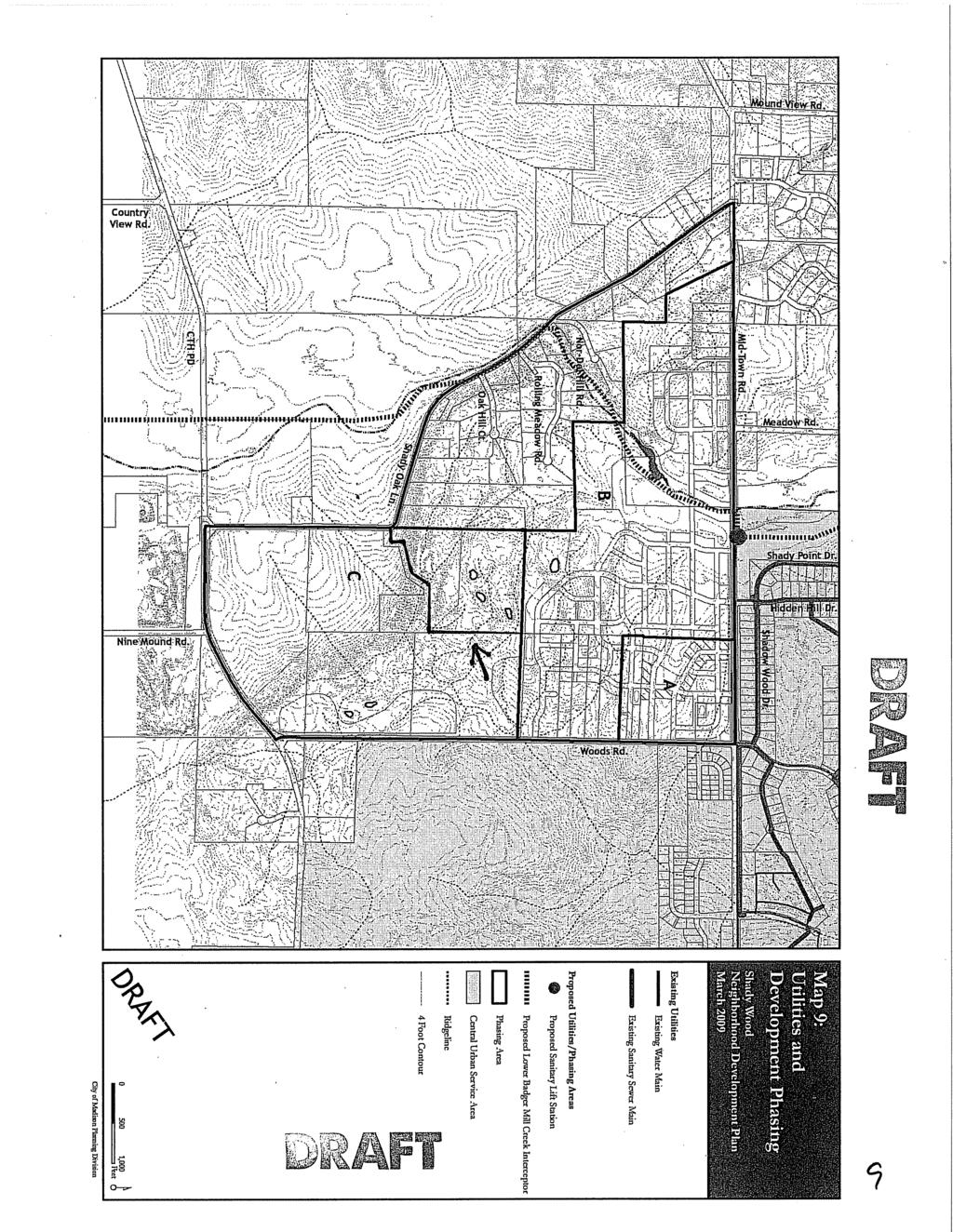
1 Report to the Plan Commission Legistar I.D. #24825, Extraterritorial Certified Survey Map Requested Action: Consideration of a two-lot Certified Survey Map (CSM) of the Keryluk-Wee property located at,, in the City of Madison s Extraterritorial Jurisdiction. Applicable Regulations & Standards: Section 16.23, Land Subdivision Regulations, Madison General Ordinances provides the requirements for land divisions located within the corporate limits of the City of Madison or within the Extraterritorial Plat Approval Jurisdiction. Summary Recommendation: The Planning Division recommends that the Plan Commission approve this Certified Survey Map subject to input at the public hearing and the comments and conditions from reviewing agencies beginning on page 5 of this report. Background Information Applicant & Property Owner: Surveyor: Kenneth Keryluk & Melissa Wee; ; Verona. Thom Grenlie; 400 S. Nine Mound Road; Verona. Proposal: The applicants propose to subdivide the existing 40-acre parcel into two lots. The applicants wish to record the Certified Survey Map as soon as all regulatory approvals have been granted. Review Schedule: The State s subdivision statute, WS 236, requires that action be taken on a Certified Survey Map within 90 days of submittal unless a written extension is granted by the applicant. If no action is taken within 90 days and no extension granted, the CSM is deemed approved. The proposed CSM application was submitted to the City on November 9, Therefore, the 90-day review period for this CSM will end circa February 9, Parcel Location: A 40-acre parcel located on the northeasterly side of Shady Oak Lane, approximately a half-mile north of McKee Road (CTH PD); Verona Area School District. Existing Conditions: The subject site is developed with a two-story single-family residence and a detached accessory building located on the southern third of the property. The site is zoned County A- 1EX Exclusive Agriculture and RH-1 Rural Home District. Surrounding Land Uses: The north side of Shady Oak Lane northwest of the subject site is developed with single-family residences on large lots, while properties south, southwest and east of the subject site are primarily large, undeveloped agricultural tracts. Environmental Corridor Status: The subject site is not located in the Central Urban Service Area and is not located in a mapped environmental corridor. Corridor map A11 shows areas of steep slope greater than 12% primarily on the southern portion of the property just off of Shady Oak Lane, and woodlands present on most of the property. Three ponds are also identified on the corridor map on the northern half of the 40-acre site.
2 Page 2 Public Utilities and Services: Water: Property is not served by municipal water. Sewer: Property is not served by municipal sewer. Fire protection: Verona Fire Department Emergency medical services: Fitch-Rona EMS Police services: Dane County Sheriff s Department School District: Verona Area School District Project Review, Analysis & Conclusion Proposed Land Division: The property owners, Kenneth Keryluk and Melissa Wee, are requesting approval of a two-lot extraterritorial Certified Survey Map to divide their 40-acre parcel located on the northeasterly side of Shady Oak Lane in the. The subject site is developed with a twostory single-family residence located approximately 500 feet northeast of Shady Oak Lane in the southwestern quadrant of the irregularly shaped parcel, and a large detached accessory building located 400 feet northeast of the house closer to the center of the property. The remainder of the property is undeveloped and characterized by heavy tree cover. Access to the property is provided by an asphalt driveway that extends into the site along the southerly property line and around to the north side of the residence. A gravel drive extends off of the asphalt drive to provide access to the accessory building and two ponds located on the northern half of the site. The subject site has approximately 73 feet of frontage on Shady Oak Lane and is characterized by slopes that fall to the southwest and northeast from a ridge that crosses the southwestern quadrant of the site, with the slopes steepest on the southwest side. Shady Oak Lane extends between McKee Road (CTH PD) on the south and Mid Town Road on the north. The site is situated on the northeast side of the road. Properties generally west of the site along the northeasterly side of Shady Oak Lane are largely characterized by a mix of single-family residences on large tracts of land, while properties to the south and west along the road consist of undeveloped agricultural tracts with farmhouses and related accessory buildings continuing south toward McKee Road. The CSM proposes to create a 3.4-acre lot for the existing residence, which is shown as Lot 1, with the remaining approximately 36.6 acres of the property including the detached accessory building to be located on proposed Lot 2. The property owners indicate that the purpose of the land division is for refinancing and estate planning purposes. No additional development is proposed at this time. As proposed, Lot 1 will be landlocked in part due to the very limited road frontage the 40-acre property has, which makes providing road frontage for both proposed lots difficult. The property is zoned County A- 1EX Exclusive Agriculture with the exception of an area of RH-1 Rural Home District zoning, which was recently enlarged from a small area surrounding the residence to encompass proposed Lot 1. Approval of CSM by and Dane County: Section 16.23(3)(c) of the Subdivision Regulations requires that subdivisions in the City s Extraterritorial Plat Approval Jurisdiction receive approval from the town of record and Dane County prior to consideration of the request by the Plan Commission. The Dane County Zoning & Land Regulation Committee conditionally approved an earlier one-lot version of the proposed land division that created just one lot for the residence as outlined in the letter dated November 1, 2011 from Dan Everson, Land Division Review, Dane County Department of Planning and Development and the map attached thereto. The rezoning of proposed Lot 1 to the RH-1
3 Page 3 Rural Home zoning was approved by the County Board on November 3, The approved the rezoning and one-lot CSM for the residence on October 4, However, the earlier one-lot CSM creating a lot for the residence and an unmapped 36.6-acre parcel is not permitted under the City s Subdivision Regulations, which require that any lot 40 acres or less in area created by a subdivision be shown on the final plat or CSM. Therefore, the CSM was revised prior to submittal to the City to include a lot for the remaining 36.6 acres of the subject property. Following City approval of the proposed two-lot CSM, the Town and County will be required to reapprove the land division prior to its recording. City of Madison Land Use Plan: The property is located within the boundaries of the proposed Shady Wood Neighborhood Development Plan planning area, which encompasses the eastern half of a highpriority peripheral planning area identified in the Comprehensive Plan for the northern tier of the Town of Verona. Planning Area A (Group 1) was identified as a high priority for more detailed neighborhood planning in order to further define the City of Madison s near and long-term interests in serving future urban development and expansion in the area, and for refining plans for a recommended open space corridor and Ice Age Trail connection to traverse the area located generally east of the large-lot development along Shady Oak Lane. The Shady Wood planning area is bounded by Shady Oak Lane on the west, Midtown Road on the north, S. Pleasant View Road (CTH M) on the east and McKee Road (CTH PD) on the south and includes the subject site. As drafted, the neighborhood plan recommends the southern half of the subject site for low-density residential development consistent with the existing residential character of the properties along the northeasterly side of Shady Oak Lane. The northern portion of the property is recommended for open space conservation and is crossed by the potential future Ice Age Trail corridor, which crosses the planning area generally from the southeast to the northwest. On July 21, 2009, the City of Madison Common Council adopted Development Phasing Area A of the Shady Wood Neighborhood Development Plan, which is one of three development phasing areas identified in the draft plan. The Common Council referred action on the balance of the neighborhood development plan in order to allow more time to consider the concerns expressed by some of the Phasing Area B and C property owners (including the applicants for this CSM) regarding the recommendations for their properties. Staff anticipates resuming discussions on the Phasing Area B and C plan recommendations in 2012 with a goal of completing the plan next year. The subject site is located in Phasing Area C of the draft plan. Land Division Criteria: The Plan Commission shall determine that the proposed land division complies with each of the following criteria: 1. The proposed subdivision or land division shall be compatible with adjacent development patterns and shall maintain the general land development pattern of the area in question. Measures of compatibility shall consider lot sizes, traffic generation, access, noise and visual features. 2. The proposed subdivision or land division and the resulting development shall not demonstrably adversely affect the City s ability to provide public services, install public improvements or accomplish future annexations. The Plan Commission may consider annexation agreements with the property owner in order to comply with this requirement. The Plan Commission may also consider whether the City and Town(s) have reached an
4 Page 4 agreement on necessary public improvements and public services facilities required to serve the development. The Planning Division generally believes that the Plan Commission can find the above criteria met with the proposed two-lot land division. Staff believes that the proposed lot for the existing residence is generally in keeping with the other residential lots present further to the west on the more developed section of Shady Oak Lane. In addition to the inclusion of the second lot (Lot 2) to the proposed CSM in order for the proposal to conform to the City s Subdivision Regulations, the configuration of the proposed land division changed at the request of City Planning staff. As approved by the Town and County, the lot for the existing residence extended southwesterly to Shady Oak Lane, which landlocked the remaining 35-plus acres of the property to the north. However, Planning staff was concerned that isolating the portion of the subject site that could potentially be developed in the future might have a negative impact on the ability for the draft recommendations of the Shady Wood Neighborhood Development Plan to be implemented in the future once the plan is adopted, including the recommendations that the undeveloped northern half of the property be preserved as open space and as a potential corridor for the extension of the Ice Age Trail through the neighborhood. Given the apparent size and age of the existing residence on Lot 1, it seems unlikely to staff that any future development on Lot 2 would call for the demolition of the house. Likelier, any future development would likely incorporate the existing residence in some fashion. By including the residence on a separate lot with access to Shady Oak Lane via an easement, staff believes that it can be found that the proposed land division will not adversely affect the City s ability to provide public services, install public improvements or accomplish future annexations in this area. In the interim, the two proposed lots will share a driveway with Lot 2 via an easement that will be declared prior to the final approval and recording of the CSM. To ensure that Lot 1 has sufficient access to Shady Oak Lane in the future, staff recommends a provision be added to the forthcoming joint driveway/ easement that ensures that access to Lot 1 will be provided as part of any further subdivision of Lot 2. Finally, the approval of this two-lot land division will require the Plan Commission to grant a waiver to the requirement in Section 16.23(8)(d)2 that every lot in a subdivision or land division shall front or abut on a public street unless the lot is located in an approved Planned Commercial Site or a Planned Development zoning district, and which is served by a reciprocal agreements or easements for land use, access, etc. Section 16.23(10) allows the Plan Commission to waive or vary the subdivision design provisions in Section 16.23(8) if the proposed subdivision is located outside the corporate limits or if extraordinary hardship would result from the literal application of those provisions. In this case, the Planning Division believes the 40-acre parcel s existing limited road frontage renders it very difficult to provide meaningful frontage for both lots, and given the limited nature of the land division request, feels that the recommended condition to create shared access between both lots is sufficient and warrants the granting of the waiver. [Report continues on the next page]
5 Page 5 Recommendation and Proposed Conditions of Approval Major/Non-Standard Conditions are shaded Planning Division Recommendation (Contact Timothy M. Parks, ) The Planning Division recommends that the Plan Commission approve the Certified Survey Map dividing, into two lots, subject to input at the public hearing and the following conditions of approval: 1. The applicants shall execute a restrictive covenant over Lot 2 of the CSM in a form approved by the Planning Division prior to final City approval of the CSM for recording. The restrictive covenant shall require written approval of the City of Madison Planning Division of the location of any new or expanded principal or accessory buildings located on Lot 2, and City of Madison Plan Commission approval of any further subdivision of Lot That the applicants receive approval of a revised two-lot land division from the and Dane County prior to the City of Madison signature on the final CSM. Proof of Town and County approval shall be in the form of written correspondence from both entities noting said approvals. Should the configuration of the land division approved by the Town and County differ from the land division approved by the City, the Director of the Planning Division shall approve the final CSM if the land division concept is compatible with the concept approved by the City Plan Commission. 3. The applicants shall create a joint driveway easement/ agreement to benefit both proposed lots, with the final easement/ agreement to be approved by the Planning Division and executed by the owners prior to final approval of the CSM for recording. The joint driveway/ easement shall include a provision ensuring that access to Lot 1 will be provided as part of any further subdivision of Lot 2. The following conditions have been submitted by reviewing agencies: City Engineering Division (Contact Janet Dailey, ) 4. Place a note on the CSM stating the following: Lot 1 and Lot 2 acknowledge they are dependent on each other for cross drainage. 5. Remove the reference to 12-foot drainage easements on page 2 and remove paragraph B of the drainage notes on page 3. NOTE: City Office of Real Estate Services comments requested the inclusion of language referring to dedication within the Owner s Certificate relating to these easements. With City Engineering suggesting the removal of these easements, this language is not required in the owner s Certificate unless there is intent to dedicate the portion of Shady Oak Lane to the public. 6. Include the land tie to the PLSS corner at the SW Corner Sec Based on dimensions shown on this CSM, this distance omitted from this CSM computes to feet. This matches the tie for prior CSM 12342, yet differs from the foot dimension for the same common line on CSM Make any necessary corrections to all recorded documents. Office of Real Estate Services (Contact Jennifer Frese, ) 7. The Owner s Certificate on the proposed plat shall be executed by all parties having an ownership interest in the property. For parties other than sole proprietorships, the signatories shall provide to
6 Page 6 the City, prior to approval, documentation, which proves that, said signatories have legal authority to sign the Owner s Certificate. The title report shows the following parties have an ownership interest of record in the property and said parties shall be signatories on the Owner s Certificate: Kenneth S. Keryluk and Melissa E. Wee, husband and wife as survivorship marital property 8. All real estate taxes, stormwater management charges, and special assessments due against the properties involved in this final plat shall be paid in full (with copies of receipts for recent payments not reflected in City records) prior to final signoff of the CSM for recording. As of December 6, 2011, the 2010 real estate taxes are known and paid in full for the subject property. The 2011 tax bills are typically released in mid-december. If the 2011 tax bill becomes available prior to CSM approval sign-off, they will also need to be paid in full. Special assessments for trash pickup are paid in full. 9. If applicable, a certificate of consent by the mortgagee/vendor shall be included following the Owner(s) Certificate for each of the mortgagees/vendors recorded against this property (State Bank of Cross Plains (2 mortgages)). 10. Please depict, name and identify all existing easements by document number in record title on the proposed CSM. They include, but are not limited to, the following: Doc. # ; Doc. # Record satisfactions or releases for all mortgages, liens, judgments, or other instruments that encumber the title of the subject lands, but where the purpose for such instrument has been satisfied, fulfilled, or resolved: Judgments exist against the property owners, as docketed on March 14, 2008 in Dane County Circuit Court, Case Number 2002CV

7
8
Report to the Plan Commission February 4, 2013
 Report to the Plan Commission Legistar I.D. #28789 Conditional Use Requested Actions: Approval of a conditional use for a structure exceeding 10,0000 square feet of total floor area and an accessory building
RE: File No. LD 1516 Certified Survey Map Tradewinds Parkway (B-R Enterprises of Madison, LLC)
") Department of Planning & Community & Economic Development Planning Division Katherine Cornwell, Director Madison Municipal Building, Suite LL-100 215 Martin Luther King, Jr. Boulevard P.O. Box 2985 Madison,
Department of Planning & Community & Economic Development Planning Division Katherine Cornwell, Director Madison Municipal Building, Suite LL-100 215 Martin Luther King, Jr. Boulevard P.O. Box 2985 Madison,
Report to the Plan Commission October 1, 2012
 Report to the Plan Commission Legistar I.D. #27437 5922 Lien Road Re-approving PUD-GDP Zoning Requested Action: Approval of a request to rezone parcels generally addressed as 5922 Lien Road from Planned
Applicable Regulations & Standards: The subdivision process is outlined in Section 16.23(5)(b) of the Subdivision Regulations.
(b) of the Subdivision Regulations.") PLANNING DIVISION STAFF REPORT PREPARED FOR THE PLAN COMMISSION Project Address: Application Type: Final Plat Legistar File ID # 33674 Prepared By: Summary Timothy M. Parks, Planning Division Report includes
PLANNING DIVISION STAFF REPORT PREPARED FOR THE PLAN COMMISSION Project Address: Application Type: Final Plat Legistar File ID # 33674 Prepared By: Summary Timothy M. Parks, Planning Division Report includes
Chapter 100 Planned Unit Development in Corvallis Urban Fringe
 100.100 Scope and Purpose. Chapter 100 Planned Unit Development in Corvallis Urban Fringe (1) All applications for land divisions in the Urban Residential (UR) and Flood Plain Agriculture (FPA) zones within
/ Planning and Zoning Commission Staff Report Jay Walker- All Terra Consulting - RZ
 / Planning and Zoning Commission Staff Report Jay Walker- All Terra Consulting - Hearing Date: January 17, 2019 Development Services Department Applicant: Jay Walker All Terra Consulting Staff: Jennifer
Requested Action: Approval of a final plat creating 25 single-family lots and 1 outlot for stormwater management.
 PLANNING DIVISION STAFF REPORT PREPARED FOR THE PLAN COMMISSION Project Address: Application Type: Final Plat Prepared By: Reviewed By: Summary Timothy M. Parks, Planning Division Report includes comments
PLANNING DIVISION REPORT DEPARTMENT OF PLANNING AND COMMUNITY AND ECONOMIC DEVELOPMENT Of July 1, 2008
 PLANNING DIVISION REPORT DEPARTMENT OF PLANNING AND COMMUNITY AND ECONOMIC DEVELOPMENT Of RE: I.D. # 10651: Zoning Map Amendment ID 3371, Rezoning from R2T, R2Y & R2Z to R2T; I.D. #11131, Approval of the
Report to the Plan Commission March 4, 2013
 Report to the Plan Commission Legistar Preliminary Plat & Final Plat Requested Action: Approval of a preliminary plat creating a total of 25 single-family residential lots and 2 outlots for stormwater
PLANNING DIVISION STAFF REPORT February 10, Summary PREPARED FOR THE PLAN COMMISSION. Zoning Map Amendment and Preliminary Plat
 PLANNING DIVISION STAFF REPORT PREPARED FOR THE PLAN COMMISSION Project Address: Application Type: Legistar File ID # 32565 and 32284 Prepared By: Reviewed By: Summary Zoning Map Amendment and Preliminary
STAFF REPORT. Permit Number: Porter. Kitsap County Board of Commissioners; Kitsap County Planning Commission
 STAFF REPORT Permit Number: 15 00461 Porter DATE: November 9, 2015 TO: FROM: Kitsap County Board of Commissioners; Kitsap County Planning Commission Katrina Knutson, AICP, Senior Planner, DCD and Jeff
LETTER OF APPLICATION
 Description of Proposed Land Division: LETTER OF APPLICATION The proposed land division would split a 1.94 acres rectangular lot into two lots. The general configuration would have one lot in front of
Ricker - PH / Planning and Zoning Commission Staff Report
 / Planning and Zoning Commission Staff Report Ricker - PH2018-20 Hearing Date: April 19, 2018 Development Services Department Applicant: Don Ricker Staff: Dan Lister, Planner II dlister@canyonco.org Tax
SUBDIVISION, PLANNED UNIT DEVELOPMENT, ZONING AMENDMENT, & SIDEWALK WAIVER STAFF REPORT Date: July 19, 2018
 SUBDIVISION, PLANNED UNIT DEVELOPMENT, ZONING AMENDMENT, & SIDEWALK WAIVER STAFF REPORT Date: July 19, 2018 NAME SUBDIVISION NAME LOCATION West Mobile Properties, LLC U.S. Machine Subdivision 556, 566,
CITY OF MADISON, WISCONSIN
 CITY OF MADISON, WISCONSIN A SUBSTITUTE ORDINANCE Amending Secs. 4.09(13), 16.23(8)(f), 16.23(9)(e), 20.04(18)(a), 20.06, and 20.09 relating to the imposition and collection of subdivision service costs
APPLICATION FOR LOT SPLIT
 APPLICATION FOR LOT SPLIT ELIGIBILITY Section 12.09.01 of the Land Development Code provides for review and approval of lot split, which shall include any of the following: 1. The division of a single
Transfer and Conveyance Standards of the Athens County Auditor and the Athens County Engineer. Table of Contents
 Transfer and Conveyance Standards of the Athens County Auditor and the Athens County Engineer Table of Contents Adoption of Standards Governing Conveyances of Real Property in Athens County, Ohio... 3
A. Appropriate agency responsible for transportation review for the subject property.
 7.8.10 Procedure Any person desiring to create a minor subdivision shall submit to the Commission for approval an application on forms provided by the Division, and a record plat in conformance with the
(if more than one, give square footage for each) ANNEXATION LOT LINE Adjustments PRE/FINAL PLAT SPECIAL USE PERMIT
 ANNEXATION LOT LINE Adjustments PRE/FINAL PLAT SPECIAL USE PERMIT") Planning Commission Application Building & development office 915 Third ST. Rawlins WY ph. 307-328-4599 fax. 307-328-4590 PROJECT REVIEW: GENERAL INFORMATION Project name: OFFICE USE ONLY Site address
Planning Commission Application Building & development office 915 Third ST. Rawlins WY ph. 307-328-4599 fax. 307-328-4590 PROJECT REVIEW: GENERAL INFORMATION Project name: OFFICE USE ONLY Site address
Staff Report for Council Public Meeting
 Agenda Item 3.3 a Staff Report for Council Public Meeting Date of Meeting: April 11, 2018 Report Number: SRPRS.18.087 Department: Division: Subject: Planning and Regulatory Services Development Planning
SUBDIVISION, PLANNED UNIT DEVELOPMENT, PLANNING APPROVAL, ZONING AMENDMENT, & SIDEWALK WAIVER REQUEST STAFF REPORT Date: February 17, 2010
 SUBDIVISION, PLANNED UNIT DEVELOPMENT, PLANNING APPROVAL, ZONING AMENDMENT, & SIDEWALK WAIVER REQUEST STAFF REPORT Date: February 17, 2010 APPLICANT NAME SUBDIVISION NAME DEVELOPMENT NAME LOCATION David
COUNTY OF ALBEMARLE APPLICATION FOR RURAL SUBDIVISION
 Page 1 APPLICATION FOR RURAL SUBDIVISION The term rural subdivision means a type of subdivision that is located in the rural areas which results in two or more lots for the purpose of transfer of ownership
ARTICLE 15 - PLANNED UNIT DEVELOPMENT
 Section 15.1 - Intent. ARTICLE 15 - PLANNED UNIT DEVELOPMENT A PUD, or Planned Unit Development, is not a District per se, but rather a set of standards that may be applied to a development type. The Planned
APPLICANT NAME SUBDIVISION NAME DEVELOPMENT NAME LOCATION. CITY COUNCIL DISTRICT Council District 4 PRESENT ZONING PROPOSED ZONING
 SUBDIVISION, PLANNED UNIT DEVELOPMENT, PLANNING APPROVAL, ZONING AMENDMENT, & SIDEWALK WAIVER REQUEST STAFF REPORT Date: February 17, 2010 APPLICANT NAME SUBDIVISION NAME DEVELOPMENT NAME LOCATION David
FIRST AMENDMENT TO DEVELOPMENT AGREEMENT FOR PLAT OF BEAR TREE FARMS LOCATED IN THE VILLAGE OF WINDSOR, DANE COUNTY, WISCONSIN
 FIRST AMENDMENT TO DEVELOPMENT AGREEMENT FOR PLAT OF BEAR TREE FARMS LOCATED IN THE VILLAGE OF WINDSOR, DANE COUNTY, WISCONSIN THIS FIRST AMENDMENT TO DEVELOPMENT AGREEMENT is executed by and between Bear
(Draft Glenville ordinance, June 2008) ARTICLE XXII Transfer of Development Rights
 ARTICLE XXII Transfer of Development Rights") (Draft Glenville ordinance, June 2008) ARTICLE XXII Transfer of Development Rights 270-161. Purpose. The primary purpose of establishing a transfer of development rights (TDR) program is to permanently
(Draft Glenville ordinance, June 2008) ARTICLE XXII Transfer of Development Rights 270-161. Purpose. The primary purpose of establishing a transfer of development rights (TDR) program is to permanently
ARTICLE V. PRELIMINARY PLAT
 ARTICLE V. PRELIMINARY PLAT PAGE 13 SECTION A. PURPOSE. The purpose of the preliminary plat is to allow the Planning and Zoning Commission to review overall platting of the tract and street patterns within
STAFF REPORT FOR MAJOR SUBDIVISION
 STAFF REPORT FOR MAJOR SUBDIVISION FINAL PLAT CASE NO. FA-12-002 HEARING DATE: September 5, 2012 CASE NAME: Solterra Subdivision Filing No. 12 PROCEDURE: Planning Commission ADDRESS OF MAJOR SUBDIVISION
Certified Survey Map (CSM) Submittal Updated: 6/29/18
 Submittal Updated: 6/29/18") Certified Survey Map (CSM) Submittal Updated: 6/29/18 Town of Middleton 7555 W. Old Sauk Road Verona, WI 53593-9700 Phone: 608-833-5887 Fax: 608-833-8996 info@town.middleton.wi.us The Town of Middleton
Certified Survey Map (CSM) Submittal Updated: 6/29/18 Town of Middleton 7555 W. Old Sauk Road Verona, WI 53593-9700 Phone: 608-833-5887 Fax: 608-833-8996 info@town.middleton.wi.us The Town of Middleton
9. REZONING NO Vicinity of the northwest corner of 143 rd Street and Metcalf Avenue
 9. REZONING NO. 2002-15 Vicinity of the northwest corner of 143 rd Street and Metcalf Avenue 1. APPLICANT: Andrew Schlagel is the applicant for this request. 2. REQUESTED ACTION: The applicant is requesting
Article XII. R-1 Agricultural-Low Density Residential District
 Article XII R-1 Agricultural-Low Density Residential District Section 1200. Declaration of Legislative Intent In expansion of the Declaration of Legislative Intent and Statement of Community Development
DAUPHIN CREEK ESTATES SUBDIVISION
 # 12 SUB-000076-2017 DAUPHIN CREEK ESTATES SUBDIVISION Engineering Comments: FINAL PLAT COMMENTS (should be addressed prior to submitting the FINAL PLAT for review and/or signature by the City Engineer):
Staff Report for Council Public Meeting
 Agenda Item 3.3 Staff Report for Council Public Meeting Date of Meeting: September 27, 2017 Report Number: SRPRS.17.134 Department: Division: Subject: Planning and Regulatory Services Development Planning
Town of Onalaska. A scale map depicting the portion of Pineview Drive to be officially laid out as a Town highway is attached hereto as Exhibit A.
 Town of Onalaska Special Meeting Minutes for March 31, 2011 The Town Board met on site of the Pineview Road and County OT in Onalaska for the purpose of viewing the lay out of the road as required by law.
CITY OF SANTA ROSA COMMUNITY DEVELOPMENT DEPARTMENT STAFF REPORT FOR PLANNING COMMISSION SEPTEMBER 10, 2015 APPLICANT FILE NUMBER MJP
 ITEM NO. 9 CITY OF SANTA ROSA COMMUNITY DEVELOPMENT DEPARTMENT STAFF REPORT FOR PLANNING COMMISSION SEPTEMBER 10, 2015 PROJECT TITLE Yogurt Time Center ADDRESS/LOCATION 3093 Marlow Road ASSESSOR S PARCEL
Community Development Department Planning Division 1600 First Street + P.O. Box 660 Napa, CA Napa (707)
") Community Development Department Planning Division 1600 First Street + P.O. Box 660 Napa, CA 94559-0660 Napa (707) 257-9530 PLANNING COMMISSION STAFF REPORT JUNE 16, 2016 AGENDA ITEM # 6.B. 16-0056-EXT;
Community Development Department Planning Division 1600 First Street + P.O. Box 660 Napa, CA 94559-0660 Napa (707) 257-9530 PLANNING COMMISSION STAFF REPORT JUNE 16, 2016 AGENDA ITEM # 6.B. 16-0056-EXT;
Report to the Plan Commission January 11, 2010
 Report to the Plan Commission Legistar I.D. #16769 6701-6921 McKee Rd./ 3210 Maple Grove Dr. PUD Rezoning Report Prepared By: Timothy M. Parks, Planner Planning Division Requested Action: Approval of a
Zoning Map Amendment, Demolition Permit and Preliminary Plat (Amended Request) Legistar File ID # 31820, and 31683
 Legistar File ID # 31820, and 31683") PLANNING DIVISION STAFF REPORT PREPARED FOR THE PLAN COMMISSION Project Address: Application Type: Zoning Map Amendment, Demolition Permit and Preliminary Plat (Amended Request) Legistar File ID # 31820,
PLANNING DIVISION STAFF REPORT PREPARED FOR THE PLAN COMMISSION Project Address: Application Type: Zoning Map Amendment, Demolition Permit and Preliminary Plat (Amended Request) Legistar File ID # 31820,
DEVELOPMENT DEPARTMENT STAFF REPORT DRESDEN HEIGHTS PHASE II DCI
 DEVELOPMENT DEPARTMENT Meeting Date: January 10, 2019 Item #: PZ2019-393 Project Name: Applicant and Owner: Proposed Development: Requests: STAFF REPORT DRESDEN HEIGHTS PHASE II DCI Dresden Heights Phase
2030 General Plan. December 6, 7 pm
 2030 General Plan GPAC Meeting #9 GPAC Meeting #9 December 6, 7 pm City Council Input on Working Draft Land Use Map Council discussed GPAC & PC versions of the working draft land use map 11/28 Council
TRANSFER OF DEVELOPMENT RIGHTS (TDR) ORDINANCE Revised November 2013
 ORDINANCE Revised November 2013") ARTICLE III Transfer of Development Rights (TDR) Program Part 301 Establishment and Purpose. 165-301.01. Purpose. Pursuant to the authority granted by 15.2-2316.1 and 2316.2 of the Code of Virginia, there
ARTICLE III Transfer of Development Rights (TDR) Program Part 301 Establishment and Purpose. 165-301.01. Purpose. Pursuant to the authority granted by 15.2-2316.1 and 2316.2 of the Code of Virginia, there
COUNTY OF ALBEMARLE APPLICATION FOR FAMILY DIVISION. Family Division = $742 (Provide 5 copies of plat)
") Page 1 APPLICATION FOR FAMILY DIVISION Family Division = $742 (Provide 5 copies of plat) Tier 2 Groundwater Review = $355 (Required for all plats showing lots less than 21 acres) Tier 3 Groundwater Review
Page 1 APPLICATION FOR FAMILY DIVISION Family Division = $742 (Provide 5 copies of plat) Tier 2 Groundwater Review = $355 (Required for all plats showing lots less than 21 acres) Tier 3 Groundwater Review
DRAFT FOR PUBLIC HEARING (rev. March, 2016)
") Chapter 200. ZONING Article VI. Conservation/Cluster Subdivisions 200-45. Intent and Purpose These provisions are intended to: A. Guide the future growth and development of the community consistent with
Chapter 200. ZONING Article VI. Conservation/Cluster Subdivisions 200-45. Intent and Purpose These provisions are intended to: A. Guide the future growth and development of the community consistent with
4. If any perennial surface water passes through or along the property lines of the acreage, a minimum of 200 feet or frontage should be required.
 b. Provide adequate acreage for appropriate productive use of rural residential land, such as small numbers of livestock, large gardens, etc. 3. Minimum of 200 feet of frontage on an improved county or
PURPOSE AND BACKGROUND
 To: City of Manitowoc From: Mike Slavney and Jessica Schmiedicke, planning consultants Date: November 2, 2009 Re: Extraterritorial, Annexation and Intergovernmental Policies PURPOSE AND BACKGROUND The
LETTER OF APPLICATION
 Description of Proposed Land Division: LETTER OF APPLICATION The proposed land division would split a 1.94 acres rectangular lot into two lots. The general configuration would have one lot in front of
ACTION FORM BRYAN CITY COUNCIL
 ACTION FORM BRYAN CITY COUNCIL DATE OF COUNCIL MEETING: July 8, 2014 DATE SUBMITTED: June 17, 2014 DEPARTMENT OF ORIGIN: Development Services SUBMITTED BY: Maggie Dalton MEETING TYPE: CLASSIFICATION: ORDINANCE:
MINOR SUBDIVISION INFORMATION
 A. POINTS OF CONTACT: MINOR SUBDIVISION INFORMATION Surveyor: Address: Phone #: Fax # E-Mail Address: Representative (If different from applicant): Address: Phone #: Fax # E-Mail Address: B. GENERAL INFORMATION:
Tracie & Dennis Jones Rezone, RZ
 / Planning and Zoning Staff Report Tracie & Dennis Jones Rezone, RZ2018-0014 Applicant: Tracie & Dennis Jones Staff: Deb Root, 454-7340 droot@canyonco.org Tax ID: R37886012 Current Zone: A (Agricultural)
Box Elder County Land Use Management & Development Code Article 3: Zoning Districts
 Chapter 3-8-1 Master Planned Community Zone Ordinance No. 316 as adopted August 11, 2009 Sections. 3-8-1 Purpose and Intent MPC Zones Created Eligibility Master Planned Community Application Submittal
ORDINANCE NUMBERb5"- 03
 ORDINANCE NUMBERb5"- 03 AMENDMENTS TO THE MASON COUNTY DEVELOPMENT REGULATIONS AND TITLE 16 (PLATS AND SUBDIVISIONS) REGARDING BOUNDARY LINE ADJUSTMENTS. AN ORDINANCE amending the Mason County Development
Guide to Combined Preliminary and Final Plats
 Guide to Combined Preliminary and Final Plats Introduction The Douglas County is committed to providing open, transparent application processes to the public. This Guide is provided to assist anyone interested
Concept Plan Project Narrative For 852 River Ranch Court
 Concept Plan Project Narrative For 852 River Ranch Court Date: January 5, 2016 Prepared by: Robert W. Jones II, P.E. Vortex Engineering, Inc. 2394 Patterson Rd., Ste 201 Grand Junction, CO 81505 970-245-9051
Department of Planning & Development Planning Unit
 Department of Planning & Development Planning Unit Website: www.cityofmadison.com Madison Municipal Building 215 Martin Luther King, Jr. Boulevard P.O. Box 2985 Madison, Wisconsin 53701-2985 TDD 608 266-4747
AAAA. Planning and Zoning Staff Report Zoning Text Amendment, ZOA-PH Request
 AAAA Hearing Date: September 3, 2015 Planning and Zoning Staff Report Zoning Text Amendment, ZOA-PH2015-23 Development Services Department Applicant: Request Staff: Christian Samples, 455-5958 csamples@canyonco.org
DEPARTMENT OF PLANNING JEFFERSON PARISH, LOUISIANA
 DEPARTMENT OF PLANNING JEFFERSON PARISH, LOUISIANA SUBDIVISION REPORT DOCKET NO: ES-1-17-PF SUMMARY NO.: COUNCIL DISTRICT: 2 Paul D. Johnston COUNCIL AT LARGE: A: Christopher L. Roberts B: Cynthia Lee-Sheng
ORDINANCE NO.: Adopted: August 2, 2005 Amended: March 27, 2007 Amended: September 23, Fillmore County Rural Addressing Ordinance
 ORDINANCE NO.: 2005-01 Adopted: August 2, 2005 Amended: March 27, 2007 Amended: September 23, 2008 Fillmore County Rural Addressing Ordinance Section 1 Purpose, Scope and Statutory Authorization 1-1 Purpose.
Bethel Romanian Church - Rezone, RZ
 / Planning and Zoning Staff Report Bethel Romanian Church - Rezone, RZ2018-0023 Hearing Date: November 15, 2018 Development Services Department Owners: Bethel Romanian Church, Corp. Applicant: Viorel Botos
City of Grande Prairie Development Services Department
 City of Grande Prairie Development Services Department COUNTRYSIDE SOUTH OUTLINE PLAN Prepared by: GPEC Consulting Ltd. #202, 10712-100th Street Grande Prairie, AB Council Resolution of August 20, 2001
Draft Zoning Changes for the 2nd Planning Board Public Hearing, January 22, 2018.
 Draft Zoning Changes for the 2nd Planning Board Public Hearing, January 22, 2018. No changes were made at the 1st Public Hearing. Proposed wording for the 1 st Public Hearing in red, eliminated text in
Watkinsville First Baptist Church Building and Parking Masterplan Norton Road & Simonton Bridge Road Oconee County Georgia
 Watkinsville First Baptist Church Building and Parking Masterplan Norton Road & Simonton Bridge Road Oconee County Georgia Special Use Approval A-1 CUP to A-1 with Special Use Approval Total Site Area
Implementation. Approved Master Plan and SMA for Henson Creek-South Potomac 103
 Implementation Approved Master Plan and SMA for Henson Creek-South Potomac 103 104 Approved Master Plan and SMA for Henson Creek-South Potomac Sectional Map Amendment The land use recommendations in the
Kitsap County Department of Community Development
 Kitsap County Department of Community Development Staff Report and Recommendation Annual Comprehensive Plan Amendment Process for 2018 George s Corner LAMIRD Boundary Adjustment Report Date 7/16/2018 Hearing
Draft Model Access Management Overlay Ordinance
 Draft Model Access Management Overlay Ordinance This model was developed using the City of Hutchinson and the Trunk Highway 7 corridor. The basic provisions of this model may be adopted by any jurisdiction
MAJOR SUBDIVISION APPLICATION
 Revised 2.26.18 The Department is here to assist you with your development application pursuant to the Community Development Code (CDC). This publication outlines the Major Subdivision Development Application
PLANNED UNIT DEVELOPMENT (PUD) AREA PLAN/REZONING REVIEW PROCEDURE
 AREA PLAN/REZONING REVIEW PROCEDURE") PLANNED UNIT DEVELOPMENT (PUD) AREA PLAN/REZONING REVIEW PROCEDURE Professional inquiries will be made to our Township Planning Consultant, Township Engineer, and Township Attorney to get their opinions
PLANNED UNIT DEVELOPMENT (PUD) AREA PLAN/REZONING REVIEW PROCEDURE Professional inquiries will be made to our Township Planning Consultant, Township Engineer, and Township Attorney to get their opinions
A Guide to the Municipal Planning Process in Saskatchewan
 A Guide to the Municipal Planning Process in Saskatchewan A look at the municipal development permit and the subdivision approval process in Saskatchewan May 2008 Prepared By: Community Planning Branch
NOTICE OF DECISION CITY OF CASCADE LOCKS PLANNING COMMISSION SUB 04-04
 NOTICE OF DECISION CITY OF CASCADE LOCKS PLANNING COMMISSION SUB 04-04 The City of Cascade Locks Planning Commission held a public hearing on June 10, 2004 to consider the application. The Commission s
FINAL SPUD APPLICATION
 The Planning & Development Services Department is here to assist you with your development application pursuant to the Community Development Code (CDC). This publication outlines the Final SPUD Development
Planning Commission Report
 cjly City of Beverly Hills Planning Division 455 N. Rexford Drive Beverly Hills, CA 90210 TEL. (310) 285-1141 FAX. (370) 858-5966 Planning Commission Report Meeting Date: April 28, 2016 Subject: Project
STAFF REPORT FOR MAJOR SUBDIVISION
 STAFF REPORT FOR MAJOR SUBDIVISION FINAL PLAT CASE NO. FA-13-001 HEARING DATE: November 6, 2013 CASE NAME: Solterra Subdivision Filing No. 14 PROCEDURE: Planning Commission ADDRESS OF MAJOR SUBDIVISION
DENTON Developer's Handbook
 DENTON Developer's Handbook A guide for land development in the City of Denton Department of Development Services 2017 2 Table of Contents 1. City of Denton Development Process...5 Role of the Development
STAFF REPORT. Permit Number: Lee. Kitsap County Board of Commissioners; Kitsap County Planning Commission
 STAFF REPORT Permit Number: 15 00689 Lee DATE: March 2, 2016 TO: FROM: Kitsap County Board of Commissioners; Kitsap County Planning Commission Katrina Knutson, AICP, Senior Planner, DCD and Jeff Arango,
ZONING AMENDMENT, SUBDIVISION & SIDEWALK WAIVER REQUEST STAFF REPORT Date: November 16, 2006
 ZONING AMENDMENT, SUBDIVISION & SIDEWALK WAIVER REQUEST STAFF REPORT Date: November 16, 2006 NAME SUBDIVISION NAME Terhaar & Cronley Investment Partnership P & E Subdivision LOCATION 4210 and 4218 Halls
SUBDIVISION DEFINED, EXEMPTIONS FROM DEFINITION:
 12-611: SUBDIVISION DEFINED, EXEMPTIONS FROM DEFINITION: A. 1. Minor Land Division (MLD) shall mean any division of land into four (4) or fewer lots. 2. Minor Subdivision shall mean any division of land
PLANNING COMMISSION REPORT Regular Agenda - Public Hearing Item
 Z-15-00469 Item No. 6A- 1 PLANNING COMMISSION REPORT Regular Agenda - Public Hearing Item PC Staff Report 11/16/15 ITEM NO. 6A GPI, RM12, & RS40 TO RM12; 14.756 ACRES; 5200 & 5300 CLINTON PKWY (SLD) Z-15-00469:
PLANNING COMMISSION REPORT Regular Agenda Public Hearing Item
 PC Staff Report 10/21/2013 Item No. 3B - 1 PC Staff Report 10/21/2013 ITEM NO. 3B: PLANNING COMMISSION REPORT Regular Agenda Public Hearing Item A TO CR- FP; 8.4 ACRES; 1900 W. 31 st STREET (SLD) : Consider
PLANNING COMMISSION REPORT Regular Agenda Non Public Hearing Item
 PC Staff Report 3/23/15 FDP-14-00551 Item No. 2-1 PLANNING COMMISSION REPORT Regular Agenda Non Public Hearing Item PC Staff Report 3/23/15 ITEM NO. 2: FINAL DEVELOPMENT PLAN FOR HUTTON FARMS WEST PHASE
Chapter SPECIAL USE ZONING DISTRICTS
 Chapter 20.20 Sections: 20.20.010 Urban Transition (U-T) Zoning District 20.20.020 Planned Development (P-D) Zoning Districts 20.20.010 Urban Transition (U-T) Zoning District A. Purpose. The purpose of
Department of Planning & Community & Economic Development Planning Division
 Department of Planning & Community & Economic Development Planning Division Website: www.cityofmadison.com Madison Municipal Building 215 Martin Luther King, Jr. Boulevard P.O. Box 2985 Madison, Wisconsin
1. Future Land Use FLU6.6.8 Land uses within the Rural Service Area portion of the Wekiva Study Area shall be limited to very low and low intensity
 1. Future Land Use FLU6.6.8 Land uses within the Rural Service Area portion of the Wekiva Study Area shall be limited to very low and low intensity uses to the greatest extent possible. Existing land uses
DEPARTMENT OF PLANNING JEFFERSON PARISH, LOUISIANA
 DEPARTMENT OF PLANNING JEFFERSON PARISH, LOUISIANA SUBDIVISION REPORT DOCKET NO: ES-89-15-PF SUMMARY NO: COUNCIL DISTRICT 2 Paul D. Johnston COUNCIL AT LARGE: A Chris Roberts B Elton M. Lagasse ADVERTISING
Marion County Board of County Commissioners
 Marion County Board of County Commissioners Date: 12/29/2015 P&Z: 12/28/2015 BCC: 1/12/2016 Item Number 160113Z Type of Application Rezoning Request From: A-1 (General Agriculture) To: PUD (Planned Unit
PIN , Part 1, Plan SR-713 in Lot 2, Concession 5, Township of McKim (1096 Dublin Street, Sudbury)
") STAFF REPORT Applicant: Dalron Construction Limited Location: PIN 02124-0103, Part 1, Plan SR-713 in Lot 2, Concession 5, Township of McKim (1096 Dublin Street, Sudbury) Official Plan and Zoning By-law:
STAFF REPORT Applicant: Dalron Construction Limited Location: PIN 02124-0103, Part 1, Plan SR-713 in Lot 2, Concession 5, Township of McKim (1096 Dublin Street, Sudbury) Official Plan and Zoning By-law:
SUBURBAN AND URBAN RESIDENTIAL LAND USE
 SUBURBAN AND URBAN RESIDENTIAL LAND USE GOAL 1 DISCOURAGE URBAN AND SUBURBAN DEVELOPMENT OUTSIDE INCORPORATED AREAS IN WHITMAN COUNTY, EXCEPT WITHIN DESIGNATED UNINCORPORATED COMMUNITIES, AND THOSE AREAS
Initial Project Review
 Pierce County Department of Planning and Land Services, 2401 South 35th Street, Tacoma, WA (253) 798-7037 Initial Project Review Major Amendment to Preliminary Plat: Hawks Ridge Division 1 Application
B. The Plan is in conformity with the Comprehensive Plan.
 ARTICLE 17 PLANNING UNIT DEVELOPMENT 17.01 INTENT The purpose of this Section is to permit the creation of new Planned Unit Developments, permitted as Conditional Uses where maximum variations of design
FINAL DRAFT 12/1/16, Rev. to 7/18/17
 FINAL DRAFT 12/1/16, Rev. to 7/18/17 (As Adopted 8/8/17 Effective 9/1/17) SHELTON PLANNING AND ZONING COMMISSION Proposed Amendments to Zoning Regulations I. Amend Section 23 PERMITTED USES by inserting
Town of Cary, North Carolina Rezoning Staff Report 14-REZ-02 Cary Oaks Subdivision Town Council Meeting June 12, 2014
 Town of Cary, North Carolina Rezoning Staff Report 14-REZ-02 Cary Oaks Subdivision Town Council Meeting June 12, 2014 REQUEST To Amend the Town of Cary Official Zoning Map to apply initial Cary zoning
Report to the Plan Commission October 5, 2009
 Report to the Plan Commission Legistar I.D. #15795 & 16102 8501 Mineral Point Road & 902 CTH M Rezoning, Demolition Permit, Prelim. & Final Plats Report Prepared By: Timothy M. Parks, Planner Planning
Nassau County Single Land Split Application
 NASSAU COUNTY DEPARTMENT OF PLANNING AND ECONOMIC OPPORTUNITY FLORIDA Nassau County Single Land Split Application Taco E. Pope, AICP, Director 96161 Nassau Place Yulee, Florida 32097 (904) 530-6300 APPLICATION
City and County of Broomfield, Colorado
 City and County of Broomfield, Colorado CITY COUNCIL AGENDA MEMORANDUM To: From: Mayor and City Council George Di Ciero, City and County Manager Teri Malies, Principal Planner Terrance Ware, Planning Director
PLANNING & DEVELOPMENT
 PLANNING & DEVELOPMENT STAFF REPORT Rezoning PETITION: APPLICANT: PROPERTY OWNER: TYPE OF REQUEST: SIZE OF TRACT: LOCATION: (#17-22) Rezone from A-PUD (Agri-Business Planned Unit Development) to A-PUD
DISTRICT COUNCIL FOR PRINCE GEORGE S COUNTY, MARYLAND OFFICE OF ZONING HEARING EXAMINER SPECIAL EXCEPTION 4658 DECISION
 DISTRICT COUNCIL FOR PRINCE GEORGE S COUNTY, MARYLAND OFFICE OF ZONING HEARING EXAMINER SPECIAL EXCEPTION 4658 DECISION Application: Three Chair Barber Shop Applicants: Danta L. & Felicia B. Wright/Fort
PLANNING COMMISSION REPORT Regular Agenda Public Hearing Item
 PC Staff Report 11/12/12 Item No. 2B- 1 PLANNING COMMISSION REPORT Regular Agenda Public Hearing Item ITEM NO. 2B: A TO GPI; 110 ACRES; E OF K-10 & N OF W 6 TH ST (MKM) : Consider a request to rezone approximately
TOWN OF ORO VALLEY PLANNING & ZONING COMMISSION MEETING DATE: December 6, 2011
 PLANNING & ZONING COMMISSION MEETING DATE: December 6, 2011 TO: FROM: SUBJECT: PLANNING & ZONING COMMISSION Matt Michels, Senior Planner mmichels@orovalleyaz.gov; tel. 229-4822 Public Hearing: Rancho de
EXHIBIT A. City of Corpus Christi Annexation Guidelines
 City of Corpus Christi Annexation Guidelines Purpose: The purpose of this document is to describe the City of Corpus Christi s Annexation Guidelines. The Annexation Guidelines provide the guidance and
Conceptual Scheme SE W4
 December 2012 1. PURPOSE 1.1. The purpose of a Conceptual Scheme (CS) is as follows: a) To provide a framework for the subsequent subdivision and/or development of land within the Country Residential Policy
LYON COUNTY TITLE 15 LAND USE AND DEVELOPMENT CODE LAND DIVISION REGULATIONS CHAPTERS October 19, 2017 Ordinance Draft DRAFT
 DRAFT LYON COUNTY TITLE 15 LAND USE AND DEVELOPMENT CODE LAND DIVISION REGULATIONS CHAPTERS 15.600 15.607 October 19, 2017 Ordinance Draft This page left blank intentionally DRAFT DRAFT Lyon County Contents
Letter of Intent May 2017 (Revised November 2017)
") THE BEACH AT WOODMOOR LETTER OF INTENT MAY 2017 (REVISED NOVEMBER 2017) OWNER/APPLICANT: CONSULTANT: Lake Woodmoor Holdings LLC N.E.S. Inc. 1755 Telstar Drive, Suite 211 619 North Cascade Avenue Colorado
THE BEACH AT WOODMOOR LETTER OF INTENT MAY 2017 (REVISED NOVEMBER 2017) OWNER/APPLICANT: CONSULTANT: Lake Woodmoor Holdings LLC N.E.S. Inc. 1755 Telstar Drive, Suite 211 619 North Cascade Avenue Colorado