PHASE I ENVIRONMENTAL SITE ASSESSMENT
|
|
|
- Alice Fowler
- 5 years ago
- Views:
Transcription
1 PHASE I ENVIRONMENTAL SITE ASSESSMENT SARASOTA CENTER LOTS 141, 1571, 161, AND 515 SARASOTA CENTER BLVD ENGLEWOOD, FLORIDA SEPTEMBER 21, 212 NOVA PROJECT NO. E Leaders in Environmental and Engineering Services
2 PHASE I ENVIRONMENTAL SITE ASSESSMENT SARASOTA CENTER LOTS 141, 1571, 161, AND 515 SARASOTA CENTER BLVD ENGLEWOOD, FLORIDA NOVA PROJECT NO. E SEPTEMBER 21, 212 PREPARED FOR: REO FUNDING SOLUTIONS III, LLC A GEORGIA LLC C/O THE TURNSTONE GROUP 117 PEACHTREE ST., NE, STE ATLANTA, GEORGIA 339 PREPARED BY: NOVA CONSULTING GROUP, INC. 117 HAZELTINE BOULEVARD, SUITE #4 CHASKA, MN (952)
3 EXECUTIVE SUMMARY Nova was authorized by REO Funding Solutions III, LLC to conduct a Phase I Environmental Site Assessment (ESA) of Sarasota Center Lots property consisting of four lots located at 141 (Lot#1), 1571 (Lot #2), 515 (Lot#3), and 161 (Lot#4) Sarasota Center Boulevard, Sarasota, Florida 3424 ("the Site"). Nova has conducted this ESA in general accordance with the scope and limitations of ASTM Designation E , Standard Practice for Environmental Site Assessments: Phase I Environmental Site Assessment Process. There are no exceptions to, or deletions from the ASTM standard practice and authorized Scope of Services. This Executive Summary summarizes the key findings of this assessment based on information and data available to Nova during the performance of this project. The Executive Summary also presents Conclusions and Recommendations, which are based on the conditions existing at the time of the assessment. This summary does not contain all the information that is found in the full report. Detailed information regarding these findings is provided in the corresponding section of the text of the report. The report should be read in its entirety to obtain a more complete understanding of the information provided. FINDINGS AND CONCLUSIONS The following table summarizes the findings of the significant elements of this investigation. ASSESSMENT COMPONENT Acceptable Routine Solution Phase II Reference Section Historical Review X 3. On site Operations X 4.2 Hazardous Materials X 4.5 Waste Generation X 4.6 PCBs X 4.7 Asbestos X 4.9 Lead in Drinking Water X 4.4 Storage Tanks X 4.8 Surface Areas X 4.3 Regulatory Database Review X 5. Lead Based Paint X 4.11 Radon X 4.1 Mold X 4.42 Dry Cleaners X 4.13 Other X 4.14 Surrounding Properties X 4.15 The Sarasota Center Lots Site includes approximately total acres of vacant land consisting of four lots with approximately useable acres 1.21 acres. There are no commercial improvements on any of the four lots as of the date of the Site inspection; ENVIRONMENTAL SITE ASSESSMENT SARASOTA CENTER LOTS PAGE i NOVA PROJECT NO. E
4 however the development includes a master stormwater retention system; is home to Sarasota County Government Complex, park like setting, and utilities are available. According to the Sarasota County Property Appraiser s website, a property appraiser identification number (PIN) and short version legal description has been assigned to each of the four lots. The Site is primarily zoned PID Planned Industrial Development District by Sarasota County. The PID zoning is primarily for industrial, warehousing and distribution activity and necessary supporting uses and facilities. During the Site reconnaissance, no operations indicative of known or suspect environmental concern were noted during Nova s reconnaissance. The Site reconnaissance revealed no evidence of significant past leaks or spills or improper use, storage, or generation of hazardous materials expected to have resulted in the potential for current impacts to the Site subsurface. The general vicinity of the Site is occupied by undeveloped land and light commercial properties as part of the International Trade Center light industrial development. Current uses of adjoining properties of the development in the vicinity of the four lots include grassy undeveloped land and stormwater ponds to the north and east; grassy undeveloped land and light commercial properties to the east; and stormwater ponds followed by commercial properties to the west. The available historical information indicates the Site was undeveloped wooded and grassy land since at least The historical information indicates that since at least 1985, the south portion of International Trade Center (ITC) was under development until the full development was historically apparent in 25. Overall, historic uses of the Site are not expected to have resulted in the potential for current impacts to the Site subsurface. Nova has performed a Phase I Environmental Site Assessment in conformance with the scope and limitations of ASTM Practice E of Sarasota Center Lots, located at 141 (Lot#1), 1571 (Lot #2), 515 (Lot#3), and 161 (Lot#4), Sarasota, Florida 3424; the Site. Any exceptions to or deletions from this practice are described in Section 4.1 of this report. This assessment has revealed no evidence of recognized environmental conditions associated with the Site. RECOMMENDATIONS Based on the work completed for this Phase I Environmental Assessment, Nova recommends no further environmental investigation at this time. ENVIRONMENTAL SITE ASSESSMENT SARASOTA CENTER LOTS PAGE ii NOVA PROJECT NO. E
5 TABLE OF CONTENTS EXECUTIVE SUMMARY...i 1. PROJECT DESCRIPTION Site Description Purpose Reliance Scope of Services User s Responsibilities & Obligations HYDROGEOLOGIC SETTING Geologic Setting Area Hydrogeology Records of Water Wells Hydrologic & Topographic Conditions Flood Zone Information HISTORICAL LAND USE REVIEW Site Use Summary Sanborn Fire Insurance Maps and USGS Topographic Maps Aerial Photographs City Directories Local Agency Review Sarasota County Permitting and Land Development Department Sarasota County Zoning and Survey Mapping Departments Sarasota County Property Appraiser and Clerk of Circuit Court Sarasota County Fire and Rescue Interviews Previous Reports and Proceedings Chain of Title Search and Judicial Records Review SITE RECONNAISSANCE Site Access and Limitations Current Operations/Tenants On Site Characteristics Utilities / Building Systems Chemical Use and Storage Waste Generation / Storage / Disposal Potential PCB Containing Equipment Storage Tanks / Drums Asbestos Containing Building Materials (ACBM) Lead Based Paint Radon Mold Dry Cleaners and/or Laundry Facilities Potential Additional Unidentified Site Concerns Surrounding Property Observations ENVIRONMENTAL SITE ASSESSMENT SARASOTA CENTER LOTS PAGE iii NOVA PROJECT NO. E
6 5. REGULATORY REVIEW Federal Agency Records Review State Agency, Tribal and EDR Proprietary Record Review FINDINGS/OPINIONS/CONCLUSIONS STANDARD OF CARE REFERENCES...21 ENVIRONMENTAL SITE ASSESSMENT SARASOTA CENTER LOTS PAGE iv NOVA PROJECT NO. E
7 LIST OF FIGURES 1. Site Topographic Map 2. Site Diagram 3. Site Location Map LIST OF APPENDICES Appendix A Resumes Appendix B Fire Insurance Map Documentation Appendix C Aerial Photographs Appendix D Photographic Documentation Appendix E Additional Information Appendix F Regulatory Database Evaluation Report ENVIRONMENTAL SITE ASSESSMENT SARASOTA CENTER LOTS PAGE v NOVA PROJECT NO. E
8 1. PROJECT DESCRIPTION 1.1 Site Description Site Address 141 (Lot#1), 1571 (Lot #2), 515 (Lot#3), and 161 (Lot#4) Sarasota Center Boulevard, Sarasota, Sarasota County, Florida 3424 Topographic Location Latitude (North): Longitude (West): Tenant Description Site Acreage, Building Description Site Exterior No current tenants Acreage: Approximately acres; Bldg. description: No buildings; Site includes approximately total acres of fully improved vacant land consisting of four lots with approximately 1.21 acres of useable acres. Access to the four lots is from Sarasota Center Boulevard via Fruitville Road. Paved roadways with open and wooded improved land with utility and stormwater improvements; and adjacent light commercially developed properties. A copy of a portion of the topographic map of the area, with the Site location marked, is included as Figure 1. The Site parcels are identified in the following table: SARASOTA CENTER LOTS Address/Short Legal Description Parcel # Lot # Client referenced Approx. Acreage 141 Sarasota Center Boulevard/ Lot 15, Sarasota International Trade Center North Phase 2 O Sarasota Center Boulevard/ Lot 28, Sarasota International Trade Center North Phase 2 O Sarasota Center Boulevard/ Lot 27, Sarasota International Trade Center North Phase 2 O useable due to Power Line Easement 161 Sarasota Center Boulevard Lot 32a, Sarasota International Trade Center North Phase 2a, Containing Ac M/L O Purpose The purpose of this ESA was to identify the potential for recognized environmental conditions to exist at the Site. The term recognized environmental conditions means the presence or likely presence of any hazardous substances or petroleum products on a property under conditions that indicate an existing release, a past release, or a material threat of a release of any hazardous substances or petroleum products into structures on the property or into the ground, groundwater, or surface water of the property. The term includes hazardous substances or petroleum products even under conditions in compliance with laws. The term is not intended to include de minimis conditions that generally do not present a material risk of harm to public health or the environment and that generally would not be the subject of an enforcement action if brought to the attention of appropriate governmental agencies. ENVIRONMENTAL SITE ASSESSMENT SARASOTA CENTER LOTS PAGE 1 NOVA PROJECT NO. E
9 Nova understands this ESA is also being completed to assist in qualifying for Landowner Liability Protections (LLPs) under CERCLA unless otherwise so stated in this report. Environmental issues or concerns at a property that are outside the scope of ASTM E that parties may wish to assess in connection with commercial real estate transactions include, but are not limited to the following: asbestos containing materials, radon, lead based paint, lead in drinking water, wetlands, regulatory compliance, cultural and historic resources, health and safety, ecological resources, endangered species, indoor air quality, and high voltage (EMF) power lines. These items, unless requested by the client or as deemed relevant to a Site on a case specific basis, are not included in this ESA. 1.3 Reliance The Services performed hereunder (including the reports prepared by Nova) are for the use and benefit of REO Funding Solutions III in Atlanta, Georgia and may also be relied upon by REO Funding Solutions III, LLC or any of their affiliates, agents and advisors, initial and subsequent holders from time to time of any debt and/or debt securities secured, directly or indirectly, by any participation interest in any such debt, any indenture trustee, servicer or other agent acting on behalf of such holders of such debt and/or debt securities; any rating agencies; and the institutional provider(s) from time to time of any liquidity facility or credit support for such financings, and their respective successors and assigns. 1.4 Scope of Services Nova s Scope of Services for this Phase I ESA conforms with the American Society for Testing and Materials (ASTM) due diligence standards detailed in the ASTM document Standard Practice for Environmental Site Assessments: Phase I Environmental Site Assessment Process (ASTM designation E ) and REO Funding Solutions III, LLC. Services provide d for this project included: A review of readily available topographic, geologic, and hydrogeologic information pertaining to the Site and surrounding area; A review of readily available information regarding historical land use activities at the Site, and interviews with people that have knowledge regarding the past or present uses of the Site, and with present and past owners, operators, and occupants of the Site, where feasible; A reconnaissance of the Site to visually and physically observe the Site for evidence of potential recognized environmental conditions; A limited review of federal, state, and local regulatory information records for reported potential environmental hazards on or in the vicinity of the Site; and Review of previous environmental reports, if available. No sampling or analytical testing was conducted as part of this Phase I ESA. The potential for a vapor intrusion condition to exist at the Site was not included in the Scope of this ESA. This Phase I ESA does not constitute a regulatory compliance audit of the Site; however, any obvious issues of noncompliance are noted in the report. Copies of resumes of Nova staff involved in the preparation of this report are included as Appendix A. ENVIRONMENTAL SITE ASSESSMENT SARASOTA CENTER LOTS PAGE 2 NOVA PROJECT NO. E
10 1.5 User s Responsibilities & Obligations REO Funding Solutions III, LLC, has not reported the existence of any environmental liens encumbering the Site property. REO Funding Solutions III, LLC did not report specialized knowledge and experience which provides important information regarding previous ownership or use of the Site which is material in identifying recognized environmental conditions. ENVIRONMENTAL SITE ASSESSMENT SARASOTA CENTER LOTS PAGE 3 NOVA PROJECT NO. E
11 2. HYDROGEOLOGIC SETTING Readily available hydrogeologic information was reviewed to evaluate surface and subsurface characteristics in the vicinity of the Site. This section summarizes the results of the hydrogeologic evaluation. Information reviewed for this project is listed in the Reference Section. 2.1 Geologic Setting Published geologic information indicates the following: Topographic Site Elevation Surficial Materials First Bedrock Beneath the Site, Physiographic Province / Geologic Age 34 feet above mean sea level EauGallie and Myakka Fine Sands soils the soils are poorly drained that formed in thick beds of sandy and loamy marine sediments with a moderately high to high water capacity. These soils nearly level soils are on broad flatwoods and derive from sandy marine deposits. The County lies within three physiographic provinces: the Gulf Coastal Lowlands, the Desoto Plain, and the Barrier Island Chain. (See Figure 2 1 for these Generalized Physiographic Provinces, Appendix E of this report). The majority of the County is in the Gulf Coastal Lowlands province, which ranges in elevation from sea level to approximately 4 feet. The Myakka River is the principal feature of the Gulf Coastal Lowlands. The Myakka, along with its tributaries, is the County's largest drainage system and flows into Charlotte Harbor to the south. Several small creeks, which empty into the County's bays and estuaries, drain the coastal portion of the County. The site is approximately one half mile north of Indian Creek that drains from northeast to southwest towards. Estimated depth to Limestone/Bedrock beneath Site A small part of the northeastern County lies within the Desoto Plain province, the location of the Subject Site. Elevations in this province range from 4 to 75 feet with the site elevation at approximately 34 feet. Soils in the Desoto Plain province are derived of the Arcadia Formation of the Hawthorn Group and are somewhat poorly drained with shallow sediments overlying organic hardpans, which are layers of strongly cemented material. The parent material of the soils of Sarasota County generally occurs as beds of sandy and clayey material that was transported and deposited by seawater, which covered the county a number of times during the Pleistocene. During high stands of the sea, Miocene Pliocene sediments were eroded and re deposited or were reworked on the shallow sea bottom to form marine terraces (USGS, 1991). These sediments form part of the surficial aquifer system. Greater than 1 feet below the ground surface 2.2 Area Hydrogeology Published hydrogeologic maps indicate the following: ENVIRONMENTAL SITE ASSESSMENT SARASOTA CENTER LOTS PAGE 4 NOVA PROJECT NO. E
12 Depth to groundwater beneath Site Regional groundwater flow direction Sole source aquifer (if present).5 to 2. feet below the ground surface South Southwest towards Indian Creek, approximately one half mile south of the Site. There are four freshwater bearing aquifers in Sarasota County: the surficial aquifer; two intermediate aquifers (Tamiami upper Hawthorn and Lower Hawthorn upper Tampa); and the Floridian aquifer. Most of the County's consumptive water use is derived from these aquifers. These ground water resources are extremely valuable to Sarasota County residents and must be protected. (Groundwater flow direction is estimated based on a review of published maps. Site specific groundwater flow conditions may be impacted by a variety of factors including, but not limited to, local topography, geologic anomalies, utilities, nearby wells or sumps, and local drainage patterns. Site specific groundwater information would require a groundwater investigation, which is beyond the scope of this ESA.) A statewide water table elevation model was calculated using well data, USGS topographic maps and the new Digital Elevation Model (DEM). The model also takes into account Florida's physiographic provinces and is based on a technique developed by the USGS. 2.3 Records of Water Wells Nova reviewed well log records provided by the Florida Geologic Survey for the area of the Site. These well records were compiled by the USGS and the Florida Department of Environmental Protection (FDEP) from drilling records and well log records submitted to the agency. No well records were on file for the Site. 2.4 Hydrologic & Topographic Conditions The Site topography is slopes gently to the south to southwest. Surface water drainage is expected to flow into storm water drains located along Sarasota Center Boulevard or percolate into improved master stormwater retention ponds and/or developed areas of the Site. 2.5 Flood Zone Information A review of the Flood Insurance Rate Maps, published by the Federal Emergency Management Agency, was performed. According to Panel Number D, dated May 1, 1984, the Site is located in Flood Zone C. Flood Zone C regions consist of an area located outside of the 1 year and 5 year flood plains. The distance to the nearest 1 year flood plain is approximately one mile to the southwest. ENVIRONMENTAL SITE ASSESSMENT SARASOTA CENTER LOTS PAGE 5 NOVA PROJECT NO. E
13 3. HISTORICAL LAND USE REVIEW Readily available historical information was reviewed to evaluate the previous uses of the Site, and previous uses of properties in the vicinity of the Site. This section summarizes the results of the historical evaluation. Information reviewed for this project is listed in the Reference Section. 3.1 Site Use Summary The available historical information indicates the Site was undeveloped wooded and grassy land since at least The historical information indicates that since at least 1985, the south portion of International Trade Center (ITC) was under development until the full development to the north to include the Site was historically apparent in 25. Overall, historic uses of the Site are not expected to have resulted in the potential for current impacts to the Site subsurface. The Sarasota Center Lots Site includes approximately total acres of fully improved vacant land consisting of four lots with approximately 1.21 acres of useable acres. There are no commercial improvements on any of the four lots as of the date of the Site inspection; however the development includes a master stormwater retention system; is home to Sarasota County Government Complex; park like setting; and utilities are available. According to Charlotte County Property Appraiser s website, a property appraiser identification number (PIN) and short version legal description has been assigned to each of the four lots. The Site is primarily zoned PID Planned Industrial Development District by Sarasota County. The PID zoning is primarily for industrial, warehousing and distribution activity and necessary supporting uses and facilities. The general vicinity of the Site is occupied by undeveloped land and light commercial properties as part of the International Trade Center light industrial development. Current uses of adjoining properties of the development in the vicinity of the four lots include grassy undeveloped land and stormwater ponds to the north and east; grassy undeveloped land and light commercial properties to the east; and stormwater ponds followed by commercial properties to the west. 3.2 Sanborn Fire Insurance Maps and USGS Topographic Maps Fire insurance maps were created for insurance underwriters and often contain information regarding the uses of individual structures, and the locations of fuel and/or chemical storage tanks which may have been on a particular property. Review of the EDR s fire insurance map collection indicated that no maps have been prepared for the Site area. A copy of the No Coverage Letter is included in Appendix B. 3.3 Aerial Photographs Aerial photographs for the Site area were available for review at EDR and MSN website. Photographs for the years 1941, 1957, 1969, 1977, 1985, 1994, 1998, 25, 26, 27, and 21 were reviewed for this ESA. Copies of the selected photographs are included in Appendix C. ENVIRONMENTAL SITE ASSESSMENT SARASOTA CENTER LOTS PAGE 6 NOVA PROJECT NO. E
14 Date: 1941 Scale: 1 = 6 Photo I.D. No.: 1941 EDR Description: The 1941 photo shows the Site as grassy undeveloped land with ponded areas in various locations throughout the Site. The adjacent and surrounding properties appear to be undeveloped grassy land to the north, east, south, and west; including small surface water ponds. Date: 1957 Scale: 1 = 6 Photo I.D. No.: 1957 EDR Description: The 1957 photo shows the Site as grassy undeveloped land with ponded areas in various locations throughout the Site. The adjacent and surrounding properties appear to be undeveloped grassy land to the north, east, south, and west; including small surface water ponds. Date: 1969 Scale: 1 = 6 Photo I.D. No.: 1969 EDR Description: The 1969 photo shows the Site as grassy undeveloped land with ponded areas in various locations throughout the Site. The adjacent and surrounding properties appear to be undeveloped grassy land to the north, east, south, and west; including small surface water ponds. Date: 1977 Scale: 1 = 6 Photo I.D. No.: 1977 EDR Description: The 1969 photo shows the Site as grassy undeveloped land with ponded areas in various locations throughout the Site. The adjacent and surrounding properties appear to be undeveloped grassy land to the north, east, south, and west; including small surface water ponds. Date: 1985 Scale: 1 = 6 Photo I.D. No.: Description: 1985 EDR The 1985 photo shows the Site as wooded and grassy undeveloped land. ENVIRONMENTAL SITE ASSESSMENT SARASOTA CENTER LOTS PAGE 7 NOVA PROJECT NO. E
15 The lots of the adjacent southern portion of the ITC development are being cleared for development. The adjacent and surrounding properties appear to be undeveloped grassy land to the north, east, south and west; including small surface water ponds. Date: 1994 Scale: 1 = 6 Photo I.D. No.: 1994 EDR Description: The 1994 photo shows the Site as wooded and grassy undeveloped land. The immediately adjacent properties appear the same as in the 1985 aerial photograph. The lots of the southern portion of the ITC development are partially developed with commercial properties. The adjacent and surrounding properties appear to be undeveloped grassy land to the north, east, south and west; including small surface water ponds. Date: 1998/1999 Composite Scale: 1 = 5 Photo I.D. No.: 1998/1999 Composite DOQQ EDR Description: The 1998/1999 composite aerial photo shows the Site as grass undeveloped land with a Power Line Easement visible on the north portion of Lot #3 and south of Lot#4 of the Site from west to east crossing Sarasota Center Boulevard. The immediately adjacent properties appear the same as in the 1985 aerial photograph with the exception that dredging of land to construct man made ponds are visible in the aerial photo on the northern and western adjacent properties of the Site. The lots of the southern portion of the ITC development remain partially developed with commercial properties; and the location of the current Sarasota County Government Complex appears to be under development. The adjacent surrounding properties appear to be improved grassy land and ponds to the north and west, and undeveloped grassy land to the east; including small surface water ponds. Date: 25, 26, 27 Scale: 1 = 5 Photo I.D. No.: 25, 26, 27 EDR Descriptions: The 25, 26, and 27 aerial photo shows the improved land of north phase (i.e. Phase 2) of the ITC development that includes the Site; fully improved with roadways, utilities, and stormwater management system. Sarasota Center Blvd. fully extends through the center of the development from the entrance at Fruitville Road, north to the location ENVIRONMENTAL SI TE ASSESSMENT SARASOTA CENTER LOTS PAGE 8 NOVA PROJECT NO. E
16 of Lots 3 and 4. The adjacent lots within Phase 2 of ITC have increased in light commercial development as well as the surrounding properties of the development to the south and west; and the northern and eastern adjacent properties remain improved but undeveloped grassy land with ponds. Date: 21 Scale: 1 = 5 Photo I.D. No.: 21 EDR Description: The 21 aerial photo shows the improved land of the Site; north phases (i.e. Phases 2&2A) of the ITC development includes the Site; fully improved with roadways, utilities, and stormwater management system. Sarasota Center Blvd. fully extends through the center of the development from the entrance at Fruitville Road, north to the location of Lots 3 and 4. Lots 1 and 4 appear in the photo as overgrown and ponded in some areas similar to the visual observations during the site reconnaissance. The adjacent lots within Phase 2 of ITC have increased in light commercial development and vegetation as well as the surrounding properties of the development to the south and west and the northern and eastern adjacent properties remain improved but undeveloped grassy land with ponds. No previous uses indicative of environmentally suspect practices or activities were identified on the Site on the aerials reviewed for this assessment. 3.4 City Directories Historical City directories published by R.L. Polk s City and Hill Donnelly Cross Reference Directories were reviewed at R.L. Polk s City and Hill Donnelly Cross Reference Directories for past names and businesses that were listed for the Site and adjoining properties. Copies of select city directories, from the years 1964, 1968, 1969, 1971, 1975, 198, 1986, 1987, 1989, 19, 199, 1995, 1997, 1998, 2, 23, 24, 25, 27, 29, and 21 were available for review at Sarasota Historical Center. The Site has no listings. Adjacent and surrounding listings include scattered light commercial businesses being first listed within the vicinity of the Site in the 27 City Directory. One listing, Sarasota County Government located at 11 Sarasota County Center Boulevard was first listed in the 24 City Directory. The following adjacent facilities are first listed, and continue to be listed in the 29 and 21 City Directories include the following: Dyco (1511), Palm Pages (21), Marlin Gate (2221), Palm River Electric (2223), Tropical Construction (2231), Kornhaus Drywall (2233), Sullivan Kay Page (2241), and Ferguson Waterworks (161)Albrecht Cabinets (135) on Sarasota Center Boulevard; with Albrecht Cabinets (135) listed on Global Court; on a surrounding property southwest of Lot#1. The Albrecht Cabinets site will be further discussed in the regulatory Section 5. ENVIRONMENTAL SITE ASSESSMENT SARASOTA CENTER LOTS PAGE 9 NOVA PROJECT NO. E
17 No previous uses indicative of environmentally suspect practices or activities were identified on the Site or adjacent and surrounding properties within the City Directories reviewed for this assessment. 3.5 Local Agency Review Sarasota County Permitting and Land Development Department SOURCE TYPE PHONE NUMBER Desk Rep Rita McClain (813) COMMENTS Nova reviewed the Sarasota County Permitting and Land Development Department permit database online. In addition, according to department representatives no specific permits or information were readily available for the subject property addresses. However, additional information can be obtained for the International Trade Center phases of development Sarasota County Zoning and Survey Mapping Departments SOURCE TYPE PHONE NUMBER Desk Rep Zoning Jeff Bowman (813) and Mapping Marty Duran (813) On line COMMENTS According to department representatives, the Subject Property is zoned PID Planned Industrial Development District for light commercial development; by the Sarasota County Zoning Department it is considered as improved vacant commercial land use in its current configuration; and by the Survey Mapping Department as located in Flood Zone C. Copies of materials from the file are attached as Appendix E Sarasota County Property Appraiser and Clerk of Circuit Court SOURCE TYPE On Line pa.com and COMMENTS The property is listed as owned by ATLAS FL I SPE LLC and the Site consists of four lots of approximately total acres of fully improved vacant land consisting of four lots with approximately 1.21 acres of useable acres. Copies of materials from the file are attached as Appendix E. The four lots of Site are located on the east and west sides of Sarasota Center Boulevard in the eastern portion of Sarasota, in a light commercial, wooded and grassy land area in Sarasota, Sarasota County, Florida. According to the Sarasota County Property Appraiser s website, addresses have been assigned Lot#1 4 respectively to the four lots of the site as 141, 1571, 515, and 161 Sarasota Center Boulevard, Sarasota, Florida. Please refer to the table in Section 1.1 for a listing that identifies each of the four lots of the Site. A short version legal description of each of the four lots of the Site was provided in the Appraiser s on line database Sarasota County Fire and Rescue CONTACT NAME/SOURCE TYPE PHONE NUMBER Desk Rep (941) COMMENTS According to the Sarasota County Fire & Rescue administrative office, there have been no issues involving spills, releases or hazardous materials responses to the Site vicinity. No information was available concerning the Site. ENVIRONMENTAL SITE ASSESSMENT SARASOTA CENTER LOTS PAGE 1 NOVA PROJECT NO. E
18 3.6 Interviews The Site was vacant at the time of this assessment. In addition, the User of this report did not provide Nova with current or previous property owner information. Therefore, no owner, previous owner, or tenant interviews were conducted as part of this assessment. Nova encountered data failure by not interviewing the past Site owners, tenants and adjacent property owners, as none were available for comment, did not respond to requests for information, or did not exist. However, based on our review of the available municipal, regulatory and historical information, the absence of information obtained from interviews with these individuals is not considered significant to the findings, conclusions and recommendation of this environmental site assessment (ESA). 3.7 Previous Reports and Proceedings Mr. Todd Baldree of REO Funding Solutions III LLC reported no knowledge of any pending, threatened, or past litigation, administrative proceedings, notices of violations, environmental liens, or activity and use limitations concerning the Ste i relating to hazardous substances or petroleum products. According to information available to Nova and the Client, previous environmental investigations were not conducted for the Site. 3.8 Chain of Title Search and Judicial Records Review Nova was not provided a chain of title by the Client for review as part of this Environmental Site Assessment. Nova was not requested to review judicial records as part of this Environmental Site Assessment. ENVIRONMENTAL SITE ASSESSMENT SARASOTA CENTER LOTS PAGE 11 NOVA PROJECT NO. E
19 4. SITE RECONNAISSANCE Ms. Karen L. Rider of Nova conducted a reconnaissance of the Site on September 12, 212 to identify potential recognized environmental conditions in connection with the Site. A diagram of the Site is attached as Figure 2. Selected photographs taken during the Site reconnaissance are included as Appendix D. The Sarasota Center Lots Site includes approximately total acres of fully improved vacant land consisting of four lots with approximately 1.21 acres of useable acres. There are no commercial improvements on any of the four lots as of the date of the Site inspection; however the development includes a master stormwater retention system; is home to Sarasota County Government Complex; park like setting; and utilities are available. According to Charlotte County Property Appraiser s website, a property appraiser identification number (PIN) and short version legal description has been assigned to each of the four lots. The Site is primarily zoned PID Planned Industrial Development District by Sarasota County. The PID zoning is primarily for industrial, warehousing and distribution activ ity and necessary supporting uses and facilities. The general vicinity of the Site is occupied by undeveloped land and light commercial properties as part of the International Trade Center light industrial development. Current uses of adjoining properties of the development in the vicinity of the four lots include grassy undeveloped land and stormwater ponds to the north and east; grassy undeveloped land and light commercial properties to the east; and stormwater ponds followed by commercial properties to the west. 4.1 Site Access and Limitations Nova was not escorted during the Site reconnaissance and no historical or current information was provided regarding the Site. Nova visually and physically observed four lots of the Site encompassing approximately acres of improved land and periphery of the Site and curbside views of adjacent and surrounding properties. Nova accessed the on Site roadway located on the central portion of the site and all four of the improved lots with open access from Sarasota Center Boulevard located on the Site; Nova also observed open and wooded areas and property boundaries. Weather conditions at the time of the reconnaissance were partly sunny with temperatures in the 95 degrees Fahrenheit range. Some limitations to the Site reconnaissance were encountered to include overgrown vegetation limiting full access. However, based on the undeveloped aspects of some of these areas and limited accessibility and with plain views of these areas, it is not expected to have resulted in the potential for environmental impact to the Site s subsurface. 4.2 Current Operations/Tenants No operations or tenants occupy the Site. Utilities are available to the Site lots along Sarasota Center Boulevard and light commercial properties on the surrounding lots. During the Site reconnaissance, no operations indicative of known or suspect environmental concern were noted during Nova s reconnaissance. The Site reconnaissance revealed no evidence of significant past leaks or spills or improper use, storage, or ENVIRONMENTAL SITE ASSESSMENT SARASOTA CENTER LOTS PAGE 12 NOVA PROJECT NO. E
20 generation of hazardous materials expected to have resulted in the potential for current impacts to the Site subsurface. 4.3 On Site Characteristics Nova observed no evidence of surface water features including wetlands, lagoons, impoundments, pits, ponds, drywells, creeks, pools of liquids, or other bodies of water on the Site. No evidence of sumps or catch basins, other than used for stormwater removal, was observed or reported during the Site reconnaissance. Nova observed no evidence of distressed vegetation, staining or corrosion, dumping of hazardous materials, filled areas, or patched pavement/roadways. 4.4 Utilities / Building Systems The following utilities are provided to the Site: UTILITY SERVICE Potable water and sewer Natural gas PROVIDER Sarasota County Utilities Florida Power & Light Company Electricity Florida Power & Light Company No evidence of potable drinking water wells, sumps, lift stations, or septic systems was observed on the Site. According to the 211 Sarasota County Water Quality Summary Report for the surrounding area of Sarasota, Florida the drinking water supply at the Site is in compliance with the EPA s drinking water quality standards. The information contained herein is from January 1 through December 31, 211. Parameters required other than annually also have been within the EPA guidelines. Nova noted no strong, pungent, or noxious odors during the Site visit. No evidence of fueling facilities was observed on the Site. 4.5 Chemical Use and Storage As the Site lots have no improvements, chemical storage and/or hazardous materials were not identified at the Site. 4.6 Waste Generation / Storage / Disposal As the Site lots have no improvements, there are no waste generation, storage, and disposal practices at the Site. 4.7 Potential PCB Containing Equipment Two pad mounted transformers on Lot#1 and one pole mounted on Lot#4, owned by Florida Power & Light Company, were observed on the Site. Based on the 25 date of installation (post 1979), these transformers are not expected to contain PCBs. Florida Power & Light Company would be responsible for any maintenance or replacement, provided the cause is not customer misuse. No leaks or staining were observed on or surrounding the transformers. No other potential PCB containing equipment was identified on the property during site reconnaissance. ENVIRONMENTAL SITE ASSESSMENT SARASOTA CENTER LOTS PAGE 13 NOVA PROJECT NO. E
21 4.8 Storage Tanks / Drums No aboveground storage tanks or evidence of underground storage tanks, such as fill pipes/ports or vent pipes were observed on the Site. Regulatory and municipal information identified no evidence of storage tanks at the Site. No unlabeled containers or drums were observed during the Site reconnaissance. 4.9 Asbestos Containing Building Materials (ACBM) As the Site lots have no improvements, asbestos containing materials are not present at the Site. No evidence of filling or dumping of hazardous materials was identified on the Site. 4.1 Lead Based Paint As the Site lots have no improvements, lead based paint/materials are not likely present at the Site Radon As the Site has no sub grade improvements and is not used for residential occupancy, elevated radon concentrations resulting in occupant exposure above the US EPA Action Level of 4. picocuries per liter (pci/l) are not expected to be a health risk to occupants at the Site Mold As the Site lots have no improvements, no areas of mold growth are present Dry Cleaners and/or Laundry Facilities No laundry or dry cleaning facilities were present at the Site at the time of our visit. Historical and regulatory information reviewed identified no dry cleaning or laundering facilities on the Site Potential Additional Unidentified Site Concerns No potential additional unidentified Site concerns were identified as a result of this ESA Surrounding Property Observations General observations of properties adjoining the Site were conducted in conjunction with on Site observations made September 12, 212 during Nova's Site reconnaissance and are summarized below. North Direction SURROUNDING PROPERTY OBSERVATIONS Use Power Line Easement on north property line of Lot 3 followed by undeveloped grassy and wooded land. The Power Line Easement runs south of Lot 4. Observed Chemical Use/Storage? No East Undeveloped wooded and grassy land and ponds. Sarasota Center Boulevard, improved grassy land lots, and light commercial properties; east of Lots 1 and 4. No ENVIRONMENTAL SITE ASSESSMENT SARASOTA CENTER LOTS PAGE 14 NOVA PROJECT NO. E
22 Direction SURROUNDING PROPERTY OBSERVATIONS Use Observed Chemical Use/Storage? South Light commercial properties and grassy improved lots of development No West Stormwater ponds and undeveloped land followed by Light commercial properties. Sarasota Center Boulevard, improved grassy land lots, and light commercial properties west of Lot s 2 and 3. Observations of adjacent properties did not reveal any obvious visual evidence of environmental concerns. None of the facilities listed on regulatory databases are indicative of known or suspected environmental concerns likely to have impacted the Site subsurface. No ENVIRONMENTAL SITE ASSESSMENT SARASOTA CENTER LOTS PAGE 15 NOVA PROJECT NO. E
23 5. REGULATORY REVIEW Nova reviewed regulatory agency database information compiled by Environmental Data Resources, Inc. (EDR) to help identify recognized environmental conditions in connection with the Site. Unless stated otherwise in this section, the scope of Nova s review is limited to review of the information provided by EDR, and does not include review of regulatory agency files pertaining to specific sites that may have been identified. The regulatory review incorporates the Approximate Minimum Search Distances (AMSDs) as set forth by ASTM plus any additional Client specific required search distances that may exceed the AMSDs or as deemed applicable by Nova. The EDR report includes an Orphan list of facilities that could not be precisely located due to inadequate address information. Nova reviewed this list and determined where these facilities are located relative to the Site. None of the Orphan listings are located on the Site. The information was incorporated into the discussion of the appropriate database. Additionally, Nova s field survey verifies the locations of EDR identified facilities in relation to the Site, and, if necessary, adjusts their distances and directions with respect to their actual locations. The results of the review for each database are discussed below. Databases with listings identified on or in the area of the Site are discussed separately, outside of the table. The locations for the facilities discussed in this section are shown on the figures in the EDR report, included as Appendix F. A detailed description of each regulatory database searched is included in the EDR Report. 5.1 Federal Agency Records Review DATABASE SEARCHED? Distance Searched Site Listings? Adjacent Listings? Listings w/in.25 Mile? Listings w/in.25.5 Mile? Listings w/in.5 1. Mile? NPL 1. Mile No No No No No Proposed NPL 1. Mile No No No No No Delisted NPL 1. Mile No No No No No NPL LIENS Target Property No N/A N/A N/A N/A CERCLIS.5 Mile No No No No N/A CERCLIS NFRAP.5 Mile No No No N/A N/A LIENS 2 Target Property No N/A N/A N/A N/A CORRACTS 1. Mile No No No No No RCRIS TSDF.5 Mile No No No No N/A RCRIS LQG.25 Mile No No No N/A N/A RCRIS SQG.25 Mile No No 1 N/A N/A RCRA CESQG.25 Mile No No No N/A N/A RCRA NonGen.25 Mile No No No N/A N/A US ENG CONTROLS.5 Mile No No No No No US INST CONTROLS.5 Mile No No No No No ERNS Target Property No N/A N/A N/A N/A HMIRS Target Property No N/A N/A N/A N/A DOT OPS Target Property No N/A N/A N/A N/A ENVIRONMENTAL SITE ASSESSMENT SARASOTA CENTER LOTS PAGE 16 NOVA PROJECT NO. E
24 DATABASE SEARCHED? Distance Searched Site Listings? Adjacent Listings? Listings w/in.25 Mile? Listings w/in.25.5 Mile? Listings w/in.5 1. Mile? CDL Target Property No N/A N/A N/A N/A US Brownfields.5 Mile No No No No N/A DOD 1. Mile No No No N/A N/A FUDS 1. Mile No No No No No LUCIS.5 Mile No No No No N/A CONSENT 1. Mile No No No No No ROD 1. Mile No No No No No UMTRA.5 Mile No No No No N/A ODI.5 Mile No No No No N/A MINES.25 Miles No No No N/A N/A TRIS Target Property No N/A N/A N/A N/A TSCA Target Property No N/A N/A N/A N/A FTTS Target Property No N/A N/A N/A N/A HIST FTTS Target Property No N/A N/A N/A N/A SSTS Target Property No N/A N/A N/A N/A ICIS Target Property No N/A N/A N/A N/A PADS Target Property No N/A N/A N/A N/A MLTS Target Property No N/A N/A N/A N/A RADINFO Target Property No N/A N/A N/A N/A FINDS Target Property No N/A N/A N/A N/A RAATS Target Property No N/A N/A N/A N/A The Site was not identified on any of the federal databases reviewed for this ESA. The adjacent facilities were not identified on any of the federal databases reviewed for this ESA. One (1) RCRA SQG facility was identified within the.25 mile search radius. This facility, Albrecht Cabinets, is located approximately 5 feet from the southwest side of Site Lot #1. A previous warning letter dated May 9, 25, was issued by the Florida Department of Environmental Protection (FDEP) regarding container management but no penalties or enforcement action was reported at this facility; records indicate compliance was completed by June 9, 25. This facility is located at 135 Global Court within the ITC Development. Based on regulatory status, distance, and gradient considerations, this facility is not expected to impact subsurface conditions at the Site. 5.2 State Agency, Tribal and EDR Proprietary Record Review DATABASE SEARCHED? Distance Searched Site Listings? Adjacent Listings? Listings W/In.25 Mile? Listings W/In.25.5 Mile? Listings W/In.5 1. Mile? Hazardous Waste 1. Mile No No No No No PLP 1. Mile No No No No No DEL PLP 1. Mile No No No No No State Landfill.5 Mile No No No No N/A SWRCY.5 Mile No No No No N/A LCP.5 Mile No No No No N/A ENVIRONMENTAL SITE ASSESSMENT SARASOTA CENTER LOTS PAGE 17 NOVA PROJECT NO. E
25 DATABASE SEARCHED? Distance Searched Site Listings? Adjacent Listings? Listings W/In.25 Mile? Listings W/In.25.5 Mile? Listings W/In.5 1. Mile? GA NON HSI 1. Mile No No No No No LUST.5 Mile No No No No N/A UST.25 Mile No No No No N/A LAST.5 Mile No No No No N/A AST.25 Mile No No Yes No N/A LIENS Target Property No N/A N/A N/A N/A SPILLS Target Property No N/A N/A N/A N/A AG SPILLS Target Property No N/A N/A N/A N/A INST CONTROL.5 Mile No No No No N/A VIC.5 Mile No No No No N/A Dry Cleaners.25 Mile No No No N/A N/A Brownfields.5 Mile No No No No N/A Enforcement Target Property No N/A N/A N/A N/A CDL Target Property No N/A N/A N/A N/A HWS Permit Target Property No N/A N/A N/A N/A AIRS Target Property No N/A N/A N/A N/A TIER 2 Target Property No N/A N/A N/A N/A Indian Reserve 1. Mile No No No No No Indian LUST.5 Mile No No No No N/A Indian UST.25 Mile No No No N/A N/A Coal/Gas 1. Mile No No No No No The Site and surrounding facilities within the specified search radii were not identified on any of the state, tribal or EDR proprietary databases reviewed for this ESA. ENVIRONMENTAL SITE ASSESSMENT SARASOTA CENTER LOTS PAGE 18 NOVA PROJECT NO. E
26 6. FINDINGS/OPINIONS/CONCLUSIONS Nova has conducted this ESA in general accordance with the scope and limitations of ASTM Designation E , Standard Practice for Environmental Site Assessments: Phase I Environmental Site Assessment Process. There are no exceptions to, or deletions from the ASTM standard practice and authorized Scope of Services. The Sarasota Center Lots Site includes approximately total acres of vacant land consisting of four lots with approximately useable acres 1.21 acres. There are no commercial improvements on any of the four lots as of the date of the Site inspection; however the development includes a master stormwater retention system; is home to Sarasota County Government Complex, park like setting, and utilities are available. According to the Sarasota County Property Appraiser s website, a property appraiser identification number (PIN) and short version legal description has been assigned to each of the four lots. The Site is primarily zoned PID Planned Industrial Development District by Saras ota County. The PID zon ing is primarily for industri al, warehousing and distribution activity and necessary supporting uses and facilities. During the Site reconnaissance, no operations indicative of known or suspect environmental concern were noted during Nova s reconnaissance. The Site reconnaissance revealed no evidence of significant past leaks or spills or improper use, storage, or generation of hazardous materials expected to have resulted in the potential for current impacts to the Site subsurface. The general vicinity of the Site is occupied by undeveloped land and light commercial properties as part of the International Trade Center light industrial development. Current uses of adjoining properties of the development in the vicinity of the four lots include grassy undeveloped land and stormwater ponds to the north and east; grassy undeveloped land and light commercial properties to the east; and stormwater ponds followed by commercial properties to the west. The available historical information indicates the Site was undeveloped wooded and grassy land since at least The historical information indicates that since at least 1985, the south portion of International Trade Center (ITC) was under development until the full development was historically apparent in 25. Overall, historic uses of the Site are not expected to have resulted in the potential for current impacts to the Site subsurface. Nova has performed a Phase I Environmental Site Assessment in conformance with the scope and limitations of ASTM Practice E of Sarasota Center Lots, located at 141 (Lot#1), 1571 (Lot #2), 515 (Lot#3), and 161 (Lot#4), Sarasota, Florida 3424; the Site. Any exceptions to or deletions from this practice are described in Section 4.1 of this report. This assessment has revealed no evidence of recognized environmental conditions associated with the Site. RECOMMENDATIONS Based on the work completed for this Phase I Environmental Assessment, Nova recommends no further environmental investigation at this time. ENVIRONMENTAL SITE ASSESSMENT SARASOTA CENTER LOTS PAGE 19 NOVA PROJECT NO. E


27 7. STANDARD OF CARE The services performed by Nova Consulting Group, Inc. on this project have been conducted with that level of care and skill ordinarily exercised by reputable members of the profession, practicing in the same locality, under similar budget and time constraints. We declare that to the best of our knowledge one or more of the parties involved in the preparation of this report meet the definition of environmental professional as defined in of 4 C.F.R. 312 and One or more of the parties involved in the preparation of this report have the specific qualifications based on education, training, and experience to assess a property of the nature, history, and setting of the Site. We have developed and performed the all appropriate inquiries in conformance with the standards and practices as set forth in 4 C.F.R. Part 312. No other warranty is expressed or intended. This report is exclusively for the use and benefit of those listed on the title page of this report and may not be relied upon by any other person or entity without written permission from Nova. PREPARED BY: NOVA CONSULTING GROUP, INC. Karen L. Rider, CHMM Project Manager Gina B. Coletta, E.P. National Practice Leader Anthony M. Coletta, CEM, E.P. Senior Project Manager ENVIRONMENTAL SITE ASSESSMENT SARASOTA CENTER LOTS PAGE 2 NOVA PROJECT NO. E
28 8. REFERENCES GEOLOGICAL REFERENCES Brooks, H.K., 1981, Geologic map of Florida: Institute of Food and Agricultural Sciences Service, University of Florida, scale 1:5 Brooks, H.K., and Merritt, J.M., Guide to Physiographic Divisions of Florida, 1982, Institute of Food and Agricultural Sciences Service, University of Florida Emergency Management Agency, Flood Insurance Rate Map, Panel Number, D, dated May 1, United States Department of Agriculture, Natural Resources Conservation Service, Web Soil Survey, dated September 1991, Sarasota County, Florida, accessed via the Internet, September 18, 212. United States Geological Survey, Bee Ridge, Florida, 7.5 minute topographic quadrangle, Southwest Florida Water Management District (SWFMWD), Groundwater Aquifer Resource Availability Inventory; Sarasota, County, Florida, HISTORICAL REFERENCES Aerial Photographs Environmental Data Resources, Inc. & Charlotte Co. Cartography Department R.L. Polk s City and Hill Donnelly Cross Reference Directories dated 1964, 1968, 1969, 1971, 1975, 198, 1986, 1987, 1989, 19, 199, 1995, 1997, 1998, 2, 23, 24, 25, 27, 29, and 21 R.L. Polk s City and Hill Donnelly Cross Reference Directories reviewed at Sarasota Historical Center, September 12, 212. Sanborn Maps Environmental Data Resources, Inc. (unmapped area) Sarasota County Property Appraiser s and Sarasota Clerk of Circuit Court online websites, pa.com and OTHER REFERENCES Environmental Data Resources, Inc., The EDR Radius Map Report, SARASOTA CENTER LOTS, 141, 1571, 161, and 515 Sarasota Center Boulevard, Sarasota, Florida 3424 EDR Inquiry # _2, dated September 1, 212. ENVIRONMENTAL SITE ASSESSMENT SARASOTA CENTER LOTS PAGE 21 NOVA PROJECT NO. E
29 FIGURES SITE TOPOGRAPHIC MAP SITE DIAGRAM SITE LOCATION MAP

30 SITE SITE N W E S SITE TOPOGRAPHIC MAP SARASOTA CENTER LOTS 141, 1571, 515, and 161 Sarasota Center Blvd. Sarasota, Florida NOVA PROJ. # E Source: USGS Topographic Map Bee Ridge Quadrangle 1987 Scale: 1:24
 SITE")


31 N W E S (Not to Scale) SITE DIAGRAM SARASOTA CENTER LOTS 141, 1571, 515, and 161 Sarasota Center Blvd. Sarasota, Florida NOVA PROJ. # E FIGURE 2

32 SITE N W E S SITE LOCATION MAP SARASOTA CENTER LOTS 141, 1571, 515, and 161 Sarasota Center Blvd. Sarasota, Florida NOVA PROJ. # E Figure 3
33 APPENDIX A RESUMES
34 KAREN RIDER, CHMM PROJECT MANANGER PROFESSIONAL EDUCATION University of South Florida (USF), Bachelor of Science in Microbiology 1984 Industrial Hygiene Graduate Level Courses College of Public Health, USF Four Core Courses CERTIFICATIONS/QUALIFICATIONS Certified Hazardous Materials Manager (CHMM No. 2217) Certified Professional Environmental Auditor (CPEA), BEAC, to be renewed Attended Associate Safety Professional (ASP) Course with ASSE and pursuing ASP and CSP designation Certified AHERA Asbestos Inspector and Management Planner, Recertify annually Certified Visible Emissions Inspector, Recertify semi annually Recycling Industry Operating Standard (RIOS) ISO Mgmt Systems Train the Trainer Certification OSHA 4 hour HAZWOPER Supervisor Certification and 8 Hour OSHA Supervisor's Certification Annual Refreshers Understanding Radiation Detection Equipment and Alarm Response, Authorized Radiation Trainer 1 Hr OSHA Construction Standard Course Certification NIOSH Applied Industrial Hygiene Course Certification AHERA accredited Asbestos Building Inspector and AHERA accredited Asbestos Management Planner Update Training USEPA RCRA Inspector Certification by FDEP USEPA Hazardous Materials/Personal Protection & Personal Safety Certification by USEPA USEPA Hazardous Waste Site Sampling/Groundwater Enforcement Certification by FDEP USEPA Hazardous Waste Management Certification by FDEP First Aid/CPR Certifications; Respiratory Fit Tested David J. Joseph Supervisor Safety School comprehensive Qualified Visible Emissions Evaluator, EPA Method 9, 4CFR 6USEPA Stormwater Program s Webcast Series Training, Monitoring and Reporting for EPA s 28 Multi Sector Generic Permit (MSGP) American Conference of Governmental Industrial Hygienist, Certificate of Completion in the Mold, Moisture & Remediation Workshop, Cincinnati, Ohio SELECTED EXPERIENCE Karen Rider has 2 plus years of EHS experience that include positions as an Environmental Manager, Environmental Project Manager, QA/QC Officer, County environmental specialist manager/recycling coordinator, and FDEP/EPA Hazardous Waste Compliance and Enforcement Inspector; including business development activities. Executed hundreds of multi media compliance audits, permitting projects, IAQ/IH projects, Phase I and II ESAs, as well as project management of remediations and hazardous materials emergency responses. Karen is highly versatile; adept at quickly mastering new roles and responsibilities to include implementation of EHS&Q management systems. PROFESSIONAL ORGANIZATIONS Alliance of Hazardous Materials Professionals (AHMP) American Society of Safety Engineers (ASSE) Professional Member Status National Association of Environmental Professionals (NAEP) Florida Association of Environmental Professionals (FAEP) American Conference of Governmental Industrial Hygienists (ACGIH); Institute of Hazardous Materials Management (IHMM); Board of Environmental, Health and Safety Auditor Certifications (BEAC)
35 ANTHONY M. COLETTA SENIOR PROJECT MANAGER PROFESSIONAL EDUCATION B.S., Industrial Management, University of Akron CERTIFICATIONS/QUALIFICATIONS Certified Environmental Manager Nevada (#229) HUD PCNA Training Addressing Accessibility in Capital Needs Assessments Identifying Accessibility Problems and Remedies, US Department/HUD, Washington, DC Environmental Professional AHERA Certified Asbestos Building Inspector 4 Hour HAZWOPER HUD MAP Training, Minneapolis HUD Offices Termite and Wood Destroying Pests Training, Nova Training Center SELECTED EXPERIENCE Mr. Coletta has nearly 25 years of experience in project management, account management and supervision in the environmental due diligence industry. Mr. Coletta manages portfolios and provides individual Phase I/Phase II, IAQ, and PCA services for national and international environmental and engineering projects. As such, he is directly responsible for development and management of project design, providing project supervision, and completing all classifications of environmental and engineering site assessments. Mr. Coletta is experienced in managing Phase I (ASTM E 1527) and Phase II environmental site assessments, property evaluations, and environmental compliance audits for commercial and industrial properties. Properties assessed have included industrial warehouse facilities, service stations, high rise buildings, hotels, auto dealership, retail malls, apartments and undeveloped land. Mr. Coletta has provided thousands of environmental site assessments in accordance with ASTM E1527, the USEPA All Appropriate Inquiry rules, Fannie Mae Delegated Underwriting Standards, Freddie Mac guidelines and HUD guidelines. Mr. Coletta has provided hundreds of property condition assessments in accordance with ASTM 218, Fannie Mae Delegated Underwriting Standards, Freddie Mac guidelines, HUD guidelines. TECHNICAL SPECIALTIES Environmental Site/Phase II Assessments Property Condition Assessments National Account Management Contract/Project Management PROFESSIONAL HISTORY EFI Global Terracon/HBC PSI Law Engineering, Inc.

36 PROFESSIONAL EDUCATION GINA B. COLETTA ENVIRONMENTAL PROFESSIONAL (E.P) NATIONAL PRACTICE LEADER St. Olaf College, Northfield, Minnesota, Bachelor of Arts in Biology, 1994 CERTIFICATIONS/QUALIFICATIONS - E.P.A Environmental Professional - MN/AHERA Certified Asbestos Building Inspector - NIOSH #582, Phase Contrast Microscopy Certification - 4 Hour HAZWOPER - Asbestos Management Planner - Phase II ESA Procedures and Reporting Training, Nova Training Center - HUD MAP Training, Minneapolis HUD Offices - Termite and Wood Destroying Pests Training, Nova Training Center SELECTED EXPERIENCE Ms. Coletta is the National Practice Leader of the Environmental Assessment Departments for all Nova offices. As the National Practice Leader, Ms. Coletta has a working knowledge of ASTM, AAI, each client s environmental due diligence requirements, including national lenders, bankers, brokers, insurance companies, real estate companies, HUD MAP, and, accordingly, ensures the adherence to their requirements, thereby ensuring and maintaining high client quality. She is responsible for the development and implementation of the Client specific reports. She manages and directs investigations for national and local clients, is a head technical reviewer of environmental reports, and is a client liaison. Ms. Coletta provides environmental and technical advice on real estate transactions for private and commercial, residential, industrial, and government subsidized properties. Projects range from single properties to multi site, multi state portfolios. Ms. Coletta has over seventeen (17) years experience in the environmental/architectural due diligence field, has performed, and managed thousands of Phase I ESA projects during her career, including, but not limited to management of multi Site portfolios for a multitude of clients, in accordance with ASTM E1527, the USEPA All Appropriate Inquiry rules, Fannie Mae Delegated Underwriting Standards, Freddie Mac guidelines, HUD guidelines, and other client specific scopes of work. Ms. Coletta has conducted numerous Property Condition Assessments for multifamily residential housing properties, commercial properties including, but not limited to, retail facilities and office buildings throughout the country, in accordance with ASTM 218, Fannie Mae and Freddie Mac guidelines. She has performed and directed numerous asbestos building surveys. She has also conducted noise analyses and electromagnetic frequency assessments. She is proficient in mold and radon testing investigations. PROJECT MANAGEMENT/MULTI SITE PORTFOLIOS: Managed several large multi site portfolios, including, but not limited to: a 15 site portfolio of manufactured homes; several large portfolios of resort properties throughout the United States; a large portfolio of hospital and health care facilities, and a multi hotel site portfolio. Developed scopes of work, mentored field personnel, and identified environmental risks. Tasks completed that are typical for portfolio management include: excellent written and verbal communication skills, effective communication of environmental risks, findings and conclusions and providing effective risk based results for multiple demanding client groups.
37 APPENDIX B FIRE INSURANCE MAP DOCUMENTATION


38 Sarasota Center Lots 141, 1571, 515 and 161 Sarasota Center Blvd. Sarasota, FL 3424 Inquiry Number: September 1, 212 Certified Sanborn Map Report

 is authorized to grant rights for commercial reproduction of maps by Sanborn Library LLC, the copyright holder for the collection.")

39 Certified Sanborn Map Report 9/1/12 Site Name: Sarasota Center Lots 141, 1571, 515 and 161 Sarasota, FL 3424 Client Name: Nova Consulting Jefferson Avenue Temecula, CA 9259 EDR Inquiry # Contact: Veronica Hassard The complete Sanborn Library collection has been searched by EDR, and fire insurance maps covering the target property location provided by Nova Consulting were identified for the years listed below. The certified Sanborn Library search results in this report can be authenticated by visiting and entering the certification number. Only Environmental Data Resources Inc. (EDR) is authorized to grant rights for commercial reproduction of maps by Sanborn Library LLC, the copyright holder for the collection. Certified Sanborn Results: Site Name: Sarasota Center Lots Address: 141, 1571, 515 and 161 Sarasota Center City, State, Zip: Sarasota, FL 3424 Cross Street: P.O. # BB&T FLORIDA PORTFOLIO Project: E Certification # 3B AA3A UNMAPPED PROPERTY This report certifies that the complete holdings of the Sanborn Library, LLC collection have been searched based on client supplied target property information, and fire insurance maps covering the target property were not found. Sanborn Library search results Certification # 3B AA3A The Sanborn Library includes more than 1.2 million Sanborn fire insurance maps, which track historical property usage in approximately 12, American cities and towns. Collections searched: Library of Congress University Publications of America EDR Private Collection The Sanborn Library LLC Since 1866 Limited Permission To Make Copies Nova Consulting (the client) is permitted to make up to THREE photocopies of this Sanborn Map transmittal and each fire insurance map accompanying this report solely for the limited use of its customer. No one other than the client is authorized to make copies. Upon request made directly to an EDR Account Executive, the client may be permitted to make a limited number of additional photocopies. This permission is conditioned upon compliance by the client, its customer and their agents with EDR's copyright policy; a copy of which is available upon request. Disclaimer - Copyright and Trademark notice This Report contains certain information obtained from a variety of public and other sources reasonably available to Environmental Data Resources, Inc. It cannot be concluded from this Report that coverage information for the target and surrounding properties does not exist from other sources. NO WARRANTY EXPRESSED OR IMPLIED, IS MADE WHATSOEVER IN CONNECTION WITH THIS REPORT. ENVIRONMENTAL DATA RESOURCES, INC. SPECIFICALLY DISCLAIMS THE MAKING OF ANY SUCH WARRANTIES, INCLUDING WITHOUT LIMITATION, MERCHANTABILITY OR FITNESS FOR A PARTICULAR USE OR PURPOSE. ALL RISK IS ASSUMED BY THE USER. IN NO EVENT SHALL ENVIRONMENTAL DATA RESOURCES, INC. BE LIABLE TO ANYONE, WHETHER ARISING OUT OF ERRORS OR OMISSIONS, NEGLIGENCE, ACCIDENT OR ANY OTHER CAUSE, FOR ANY LOSS OF DAMAGE, INCLUDING, WITHOUT LIMITATION, SPECIAL, INCIDENTAL CONSEQUENTIAL, OR EXEMPLARY DAMAGES. ANY LIABILITY ON THE PART OF ENVIRONMENTAL DATA RESOURCES, INC. IS STRICTLY LIMITED TO A REFUND OF THE AMOUNT PAID FOR THIS REPORT. Purchaser accepts this Report "AS IS". Any analyses, estimates, ratings, environmental risk levels or risk codes provided in this Report are provided for illustrative purposes only, and are not intended to provide, nor should they be interpreted as providing any facts regarding, or prediction or forecast of, any environmental risk for any property. Only a Phase I Environmental Site Assessment performed by an environmental professional can provide information regarding the environmental risk for any property. Additionally, the information provided in this Report is not to be construed as legal advice. Copyright 212 by Environmental Data Resources, Inc. All rights reserved. Reproduction in any media or format, in whole or in part, of any report or map of Environmental Data Resources, Inc., or its affiliates, is prohibited without prior written permission. EDR and its logos (including Sanborn and Sanborn Map) are trademarks of Environmental Data Resources, Inc. or its affiliates. All other trademarks used herein are the property of their respective owners page 2
40 APPENDIX C AERIAL PHOTOGRAPHS


41 SITE #3 #4 #2 #1 N W E Aerial photograph courtesy of EDR. Approximate Scale: 1' = 6' S 1941 AERIAL PHOTOGRAPH SARASOTA CENTER LOTS 141, 1571, 515, and 161 Sarasota Center Blvd. Sarasota, Florida NOVA PROJ. # E Aerial


42 SITE #3 #4 #2 #1 N Aerial photograph courtesy of EDR. Approximate Scale: 1' = 6' W E S 1957 AERIAL PHOTOGRAPH SARASOTA CENTER LOTS 141, 1571, 515, and 161 Sarasota Center Blvd. Sarasota, Florida NOVA PROJ. # E Aerial

43 SITE #3 #4 #2 #1 N Aerial photograph courtesy of EDR. Approximate Scale: 1' = 6' W E S 1969 AERIAL PHOTOGRAPH SARASOTA CENTER LOTS 141, 1571, 515, and 161 Sarasota Center Blvd. Sarasota, Florida NOVA PROJ. # E Aerial

44 SITE #3 #4 #2 #1 W N E Aerial photograph courtesy of EDR. Approximate Scale: 1' = 6' S 1977 AERIAL PHOTOGRAPH SARASOTA CENTER LOTS 141, 1571, 515, and 161 Sarasota Center Blvd. Sarasota, Florida NOVA PROJ. # E Aerial

45 SITE #3 #4 #2 #1 W N E Aerial photograph courtesy of EDR Approximate Scale: 1' = 6' S 1985 AERIAL PHOTOGRAPH SARASOTA CENTER LOTS 141, 1571, 515, and 161 Sarasota Center Blvd. Sarasota, Florida NOVA PROJ. # E Aerial


46 SITE #3 #4 #2 #1 N W S E Aerial photograph courtesy of EDR. Approximate Scale: 1' = 6' 1994 AERIAL PHOTOGRAPH SARASOTA CENTER LOTS 141, 1571, 515, and 161 Sarasota Center Blvd. Sarasota, Florida NOVA PROJ. # E Aerial

47 SITE #3 #4 #2 #1 N W E Aerial photograph courtesy of EDR Approximate Scale: 1' = 5' S 1998/1999 COMPOSITE AERIAL PHOTOGRAPH SARASOTA CENTER LOTS 141, 1571, 515, and 161 Sarasota Center Blvd. Sarasota, Florida NOVA PROJ. # E /1999 Composite Aerial

48 SITE #3 #4 #2 #1 N W S E Aerial photograph courtesy of EDR. Approximate Scale: 1' = 5' 25 AERIAL PHOTOGRAPH SARASOTA CENTER LOTS 141, 1571, 515, and 161 Sarasota Center Blvd. Sarasota, Florida NOVA PROJ. # E Aerial

49 SITE #3 #4 #2 #1 W N E Aerial photograph courtesy of EDR Approximate Scale: 1' = 5' S 26 AERIAL PHOTOGRAPH SARASOTA CENTER LOTS 141, 1571, 515, and 161 Sarasota Center Blvd. Sarasota, Florida NOVA PROJ. # E Aerial

50 SITE #3 #4 #2 #1 N W S E Aerial photograph courtesy of EDR Approximate Scale: 1' = 5' 27 AERIAL PHOTOGRAPH SARASOTA CENTER LOTS 141, 1571, 515, and 161 Sarasota Center Blvd. Sarasota, Florida NOVA PROJ. # E Aerial


51 SITE W N E Aerial photograph courtesy of Sarasota County Mapping/KR Approximate Scale: 1' = 5' S 21 AERIAL PHOTOGRAPH SARASOTA CENTER LOTS 141, 1571, 515, and 161 Sarasota Center Blvd. Sarasota, Florida NOVA PROJ. # E Aerial
52 APPENDIX D PHOTOGRAPHIC DOCUMENTATION


53 Sarasota Center Lots Sarasota Florida 1. View looking north from south adjacent vacant lot to towards Lot #1 of the Site (i.e. at tree line on the right) along Sarasota Center Blvd., at tree line 2. View of Lot#1 of the Site, looking SE along the western property line, drainage swale and fenced-in area for sanitary lift station observed on SW corner 3. View of central portion of Lot#1 of the Site, looking east, open grassy and wooded improved land 4. View of small de minimis amount of refuse on west central portion of Lot#1 of the Site 5. View of wooded area along south property line of Lot#1, looking east 6. View of white 1 PVC pipe protruding from ground on SW portion of Lot 1 of the Site Date of Photographs: Environmental Site Assessment Nova Project No. E


54 Sarasota Center Lots Sarasota Florida 7. View of wooded area and heavy vegetation on the eastern portion of Lot#1, looking east undeveloped land and ponded areas 8. View of stormwater pond east of Lot#1 of the Site, photo taken from Lot#2, looking northeast 9. View of northern property line and north portion of Lot#1 of the Site and the parking lot on north adjacent property, looking west 1. View of west property line of Lot#1 looking north along Sarasota Center Blvd., towards adjacent and surrounding adjacent light commercial properties 11. View of northwest corner of Lot#1 of the Site, looking southeast towards Lot #1, fire hydrant observed on northwest corner of the Site 12. View of two pad-mounted transformers on southwest corner of Lot#1of the Site, looking west at light commercial properties Date of Photographs: Environmental Site Assessment Nova Project No. E


55 Sarasota Center Lots Sarasota Florida 13. View of Sarasota Center Blvd. followed by light commercial properties looking northwest from Lot#1 of the Site, fire hydrants observed 14. View of eastern property line of Lots #2 and #3, drainage ditch, and grassy and wooded improved land, looking north along Sarasota Center Boulevard 15. View of Sarasota Center Blvd. and Lot#2 of the Site, looking west at grassy and wooded improved land 16. View of Sarasota Center Blvd. and Consumer Court followed by commercial properties, DYCO/ Mermaid Water Systems, looking southeast from Lot#2 17. View of Sarasota Center Boulevard followed by improved vacant lot, looking east from Lot#2 of the Site 18. View of central portion Lot #2 of the Site, looking south towards southern adjacent improved lot of ITC development and light commercial properties Date of Photographs: Environmental Site Assessment Nova Project No. E


56 Sarasota Center Lots Sarasota Florida 19. View of grassy and wooded improved land of Lot#2 of the Site, looking north along western property line 2. View of grassy and wooded improved land of Lot#2 of the Site, looking south along western property line 21. View of grassy and wooded improved land of Lot#3 of the Site, looking southwest 22. View of northern portion of Lot# 3 of the Site, looking northwest towards Power Line Easement on north property line followed by undeveloped land 23. View of central portion of Lot#3 of the Site and southern adjacent Lot#2 of the Site, looking south 24. View of stormwater pond of development on western adjacent improved land of development, looking west from Lot#3 of the Site Date of Photographs: Environmental Site Assessment Nova Project No. E


57 Sarasota Center Lots Sarasota Florida 25. View of Sarasota Center Boulevard and eastern adjacent property, Ferguson Waterworks, looking east from northeast corner of Lot#3 of the Site 26. View of eastern portion of Lot#4, Sarasota Center Boulevard, and power line and pole-mounted transformer on northeast corner of the Site, looking east 27. View of western property line of Lots#4 of the Site, Sarasota Center Boulevard, looking south 28. View of NW corner of Lot#4 of the Site, looking east along northern property line and southeast towards the southern adjacent property, Ferguson Waterworks 29. View from Lot#4 of the Site, looking south at exterior paved storage area of Ferguson waterworks on southern property boundary, 3. View of grassy and overgrown improved Lot#4 of the Site, looking east from Sarasota Center Boulevard Date of Photographs: Environmental Site Assessment Nova Project No. E


58 Sarasota Center Lots Sarasota Florida 31. View of the northern property line of Lot#4 of the Site; a grassy, overgrown, and wet ponded area of the site, looking east 32. View of central and SW portion of Lot#4 looking south towards southern adjacent property; overgrown and wet pond area on SW portion 33. View of overgrown area on central portion of Lot#4 of the Site, looking southwest, heaviest ponded area 34. View of fire hydrant and PVC drainage pipe positioned in ponded area of southwest portion of Lot #4 of the Site, looking northeast 35. View of heavy vegetation along the southern portion of Lot#4 of the Site, looking east 36. View of eastern property line of Lot#4 of the Site and eastern adjacent undeveloped property, looking south towards southern adjacent property, Ferguson Date of Photographs: Environmental Site Assessment Nova Project No. E


59 Sarasota Center Lots Sarasota Florida 37. View of northern adjacent undeveloped land and northern bob-wire fenced property line of Lot#4 of the Site, looking northeast 38. View of eastern adjacent undeveloped land and eastern bob-wire fenced property line of Lot#4 of the Site, looking northeast 39. View of southern chain link fenced property line of Lot#4 of the Site and southern adjacent commercial property, Ferguson, looking south 4. View of southwest corner of Lot#4 of the Site followed by southern adjacent commercial property, Ferguson, looking southeast Date of Photographs: Environmental Site Assessment Nova Project No. E
60 APPENDIX E ADDITIONAL INFORMATION
61

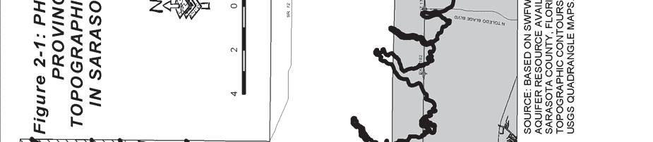
62 Figure 2-1: Physiographic Provinces and Topographic Contours
63 Parcel : Page 1 of 1 9/19/ Detail Information for Parcel Ownership ATLAS FL I SPE LLC 695 N WICKHAM RD STE 2 MELBOURNE, FL, 3294 Incorrect Mailing Address? Situs Address 1571 SARASOTA CENTER BLVD, SARASOTA, FL 3424 Parcel Characteristics Land Area: 119,613 (square feet) Incorporation: UNINCORPORATED Delineated District: N/A Subdivision Code: 2965 Use Code: 4 Sec/Twp/Rge: 16-36S-19E Census: Zoning: PID Parcel Description LOT 28, SARASOTA INTERNATIONAL TRADE CENTER-NORTH PHASE 2 Associated Personal Property No Personal Property 212 Preliminary Values (Subject to Change) Just (Market) Value: $253, Land Value: $253, Improvement Value: $ Assessed Value: $253, Homestead: No Exemptions: $ Total Taxable: $253, Improvements (Preliminary) Total Building Area: Living Area: Living Units: Bed / Bath: Pool: No Year Built: Transfer History Transaction Date Recorded Consideration Transaction Qual. Code Instrument # Seller/Grantor Instrument Type 3/3/212 $1,315, SITC INC, WD 6/16/2 $2,893, INDUSTRY PLAZA LTD, WD Show Transaction Qual. Codes Show Instrument Types Exemptions Code Description Amount No Exemptions Found Sarasota County Property Appraiser - Ph Fax Adams Lane, Sarasota, FL, Disclaimer
64 Parcel : Page 1 of 1 9/19/ Detail Information for Parcel Ownership ATLAS FL I SPE LLC 695 N WICKHAM RD STE 2 MELBOURNE, FL, 3294 Incorrect Mailing Address? Situs Address 515 SARASOTA CENTER BLVD, SARASOTA, FL 3424 Parcel Characteristics Land Area: 26,768 (square feet) Incorporation: UNINCORPORATED Delineated District: N/A Subdivision Code: 2965 Use Code: 4 Sec/Twp/Rge: 16-36S-19E Census: Zoning: PID Parcel Description LOT 27, SARASOTA INTERNATIONAL TRADE CENTER-NORTH PHASE 2 Associated Personal Property No Personal Property 212 Preliminary Values (Subject to Change) Just (Market) Value: $273,1 Land Value: $273,1 Improvement Value: $ Assessed Value: $273,1 Homestead: No Exemptions: $ Total Taxable: $273,1 Improvements (Preliminary) Total Building Area: Living Area: Living Units: Bed / Bath: Pool: No Year Built: Transfer History Transaction Date Recorded Consideration Transaction Qual. Code Instrument # Seller/Grantor Instrument Type 3/3/212 $1,315, SITC INC, WD 6/16/2 $2,893, INDUSTRY PLAZA LTD, WD Show Transaction Qual. Codes Show Instrument Types Exemptions Code Description Amount No Exemptions Found Sarasota County Property Appraiser - Ph Fax Adams Lane, Sarasota, FL, Disclaimer
65 Parcel : Page 1 of 1 9/19/ Detail Information for Parcel Ownership ATLAS FL I SPE LLC 695 N WICKHAM RD STE 2 MELBOURNE, FL, 3294 Incorrect Mailing Address? Situs Address 161 SARASOTA CENTER BLVD, SARASOTA, FL 3424 Parcel Characteristics Land Area: 149,965 (square feet) Incorporation: UNINCORPORATED Delineated District: N/A Subdivision Code: 2965 Use Code: 4 Sec/Twp/Rge: 16-36S-19E Census: Zoning: PID Parcel Description LOT 32A, SARASOTA INTERNATIONAL TRADE CENTER NORTH PHASE 2A, CONTAINING AC M/L Associated Personal Property No Personal Property 212 Preliminary Values (Subject to Change) Just (Market) Value: $253,1 Land Value: $253,1 Improvement Value: $ Assessed Value: $253,1 Homestead: No Exemptions: $ Total Taxable: $253,1 Improvements (Preliminary) Total Building Area: Living Area: Living Units: Bed / Bath: Pool: No Year Built: Transfer History Transaction Date Recorded Consideration Transaction Qual. Code Instrument # Seller/Grantor Instrument Type 3/3/212 $1,315, SITC INC, WD 6/16/2 $2,893, INDUSTRY PLAZA LTD, WD Show Transaction Qual. Codes Show Instrument Types Exemptions Code Description Amount No Exemptions Found Sarasota County Property Appraiser - Ph Fax Adams Lane, Sarasota, FL, Disclaimer
66 Parcel : Page 1 of 1 9/19/ Detail Information for Parcel Ownership ATLAS FL I SPE LLC 695 N WICKHAM RD STE 2 MELBOURNE, FL, 3294 Incorrect Mailing Address? Situs Address 141 SARASOTA CENTER BLVD, SARASOTA, FL 3424 Parcel Characteristics Land Area: 88,21 (square feet) Incorporation: UNINCORPORATED Delineated District: N/A Subdivision Code: 2965 Use Code: 4 Sec/Twp/Rge: 16-36S-19E Census: Zoning: PID Parcel Description LOT 15, SARASOTA INTERNATIONAL TRADE CENTER-NORTH PHASE 2 Associated Personal Property No Personal Property 212 Preliminary Values (Subject to Change) Just (Market) Value: $19,1 Land Value: $19,1 Improvement Value: $ Assessed Value: $19,1 Homestead: No Exemptions: $ Total Taxable: $19,1 Improvements (Preliminary) Total Building Area: Living Area: Living Units: Bed / Bath: Pool: No Year Built: Transfer History Transaction Date Recorded Consideration Transaction Qual. Code Instrument # Seller/Grantor Instrument Type 3/3/212 $1,315, SITC INC, WD 6/16/2 $2,893, INDUSTRY PLAZA LTD, WD Show Transaction Qual. Codes Show Instrument Types Exemptions Code Description Amount No Exemptions Found Sarasota County Property Appraiser - Ph Fax Adams Lane, Sarasota, FL, Disclaimer
67
68
 885-5656 (813) 417-163 Four Lots Available o 2.2 Acres o 2.75 Acres o 2.66 Acres o 2.")

69 SARASOTA INTERNATIONAL TRADE CENTER Fully Improved Industrial Lots Available From 2.2 Acres To 7.5 Acres Only $2.15 Per Useable SF CONTACT LISTING AGENT: JOE SEIDLE (813) (813) Four Lots Available o 2.2 Acres o 2.75 Acres o 2.66 Acres o 2.6 Acres Master Retention In Place Water And Sewer At Site Home Of Sarasota County Government Complex Park-Like Setting Quick Interstate Access Approved For Outside Storage Signalized Entrance Off Fruitville Road 2 Miles East Of I-75 Flood Zone C 711 North Sherrill Street Tampa, FL NOTICE TO BROKERS AND PROSPECTIVE PURCHASERS/TENANTS: THE MATERIAL CONTAINED IN THIS OFFERING IS FURNISHED SOLELY FOR THE PURPOSE OF YOUR CONSIDERATION TO PURCHASE/LEASE THE PROPERTY CONTAINED HEREIN, AND IS NOT TO BE USED FOR ANY OTHER PURPOSE WITHOUT THE EXPRESS WRITTEN CONSENT OF THE KRAUSS ORGANIZATION OR THE OWNER. THE MATERIAL IS BASED ON INFORMATION OBTAINED BY OWNER AND ON INFORMATION OBTAINED BY THE KRAUSS ORGANIZATION FROM SOURCES THEY DEEM RELIABLE. THIS IS A SUMMARY OF PERTINENT FACTS ON THE PROPERTY AND IS NOT INTENDED TO CONTAIN ALL OF THE INFORMATION DESIRED BY A PROSPECTIVE PURCHASER/TENANT. PROSPECTIVE PURCHASERS/TENANTS SHOULD MAKE THEIR OWN INVESTIGATION AND CONCLUSIONS WITHOUT RELIANCE UPON THE MATERIAL CONTAINED HEREIN. NEITHER OWNER NOR THE KRAUSS ORGANIZATION, NOR ANY OF THEIR OFFICERS, EMPLOYEES OR AGENTS MAKE ANY REPRESENTATION OR WARRANTY EXPRESSED OR IMPLIED AS TO THE ACCURACY OR COMPLETENESS OF THIS OFFERING.
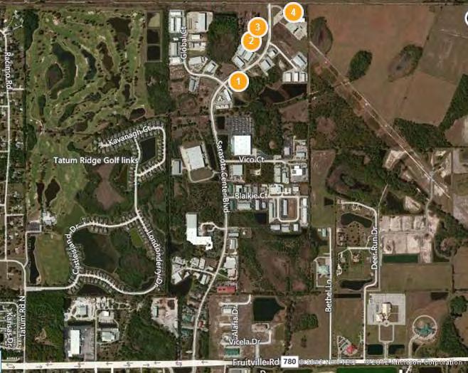
70
71

72 141 Sarasota Center Boulevard 2.2 Acres
73


74 1571 Sarasota Center Boulevard 2.75 Acres (Can be combined with 515 for a total of 7.5 Acres 5.41 useable)
75


76 515 Sarasota Center Boulevard 4.75 Acres Useable (Can be combined with 1571 for a total of 7.5 Acres 5.41 useable)
77

78 161 Sarasota Center Boulevard 3.44 Acres


79 Fruitville Road Signalized Entrance to Park Sarasota Center Boulevard

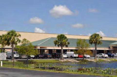
80 Sarasota County Government Complex
Environmental Audit Standards
 Environmental Audit Standards Lender requires an acceptable Phase I Environmental Audit Report, directed to Lender and historical in nature, which is to be prepared in accordance with the standards set
ENVIRONMENTAL SITE ASSESSMENT (AAI COMPLIANT PHASE I)
") ENVIRONMENTAL SITE ASSESSMENT (AAI COMPLIANT PHASE I) IPP.MORELAND AVENUE ASSEMBLAGE 785-793 MORELAND AVENUE ATLANTA, GEORGIA, 30316 ONE GROUP PROJECT #A6092 JANUARY 28, 2008 PREPARED FOR: FAIRVIEW COMMERCIAL
ENVIRONMENTAL SITE ASSESSMENT (AAI COMPLIANT PHASE I) IPP.MORELAND AVENUE ASSEMBLAGE 785-793 MORELAND AVENUE ATLANTA, GEORGIA, 30316 ONE GROUP PROJECT #A6092 JANUARY 28, 2008 PREPARED FOR: FAIRVIEW COMMERCIAL
PHASE I ENVIRONMENTAL SITE ASSESSMENT
 PHASE I ENVIRONMENTAL SITE ASSESSMENT ACME Gas 55 Garden Street Columbus, Ohio, 45123 Prepared for ACME Oil & Gas Ltd. Prepared by GAEA Environmental Services 87 Garden Street Whitby, Ontario L1N 9E7 November
Phase I Environmental Site Assessment Update Memorandum Vacant Property 1585 Santa Clara Avenue Santa Ana, California 92507
 March 1, 2011 Mr. Vincent C. Fregoso, AICP City of Santa Ana 20 Civic Center Plaza Santa Ana, CA 92702 Re: Phase I Environmental Site Assessment Update Memorandum Vacant Property 1585 Santa Clara Avenue
PHASE I ENVIRONMENTAL SITE ASSESSMENT REPORT 3.3-ACRE ECKENRODE PROPERTY WARWICK TOWNSHIP, TUSCARAWAS COUNTY, OHIO. Prepared for: OHIOLAND, LLC
 PHASE I ENVIRONMENTAL SITE ASSESSMENT REPORT 3.3-ACRE ECKENRODE PROPERTY WARWICK TOWNSHIP, TUSCARAWAS COUNTY, OHIO Prepared for: OHIOLAND, LLC Prepared by: CIVIL & ENVIRONMENTAL CONSULTANTS, INC. COLUMBUS,
PHASE I ENVIRONMENTAL ENGINEERING PHASE I REPORT 3264 PREPARED FOR: Mark Hopkins. Liberty Real Estate, LLC. 741 North State Road.
 PHASE I ENVIRONMENTAL ENGINEERING PHASE I REPORT 3264 PREPARED FOR: Mark Hopkins Liberty Real Estate, LLC 741 North State Road Salem, Utah 84653 May 25, 2012 SITE LOCATION Hawthorn Mobile Home Park 10682
DRAFT - Subject to Change. Cathedral Building 212 North Ash Street Crookston, Minnesota. Prepared For. Project FA June 29, 2011
 DRAFT Phase I Environmental Site Assessment Cathedral Building 212 North Ash Street Crookston, Minnesota Prepared For Braun Intertec Corporation Ms. Kay Hegge Prairie Skyline Foundation 27048 310th Street
Proposed Laurel 2 Solar Facility Jessup Road at Vaughn & Diehl Roads Imperial County, California
 Phase I ESA Report Proposed Laurel 2 Solar Facility Jessup Road at Vaughn & Diehl Roads Imperial County, California Prepared for: 9FI 8ME, LLC 221 Sutter Street, 6 th Floor San Francisco, CA 9418 Prepared
Hazardous Materials in Project Development Additional Guidance
 Hazardous Materials in Project Development Additional Guidance Contents:...2 AASHTO Guidance...3 USDOT Brownfields Guidance...4 ASTM Standard Practices...6 Hazardous Materials in Project Development 1
The University of Texas System Systemwide Policy. Policy: UTS Title. Environmental Review for Acquisition of Real Property. 2.
 1. Title 2. Policy Environmental Review for Acquisition of Real Property Sec. 1 Sec. 2 Policy Statement. It is the policy of The University of Texas System to minimize its potential for exposure to claims
PHASE I ENVIRONMENTAL SITE ASSESSMENT 1724 VINTON STREET & 2702 SOUTH 18 TH STREET OMAHA, DOUGLAS COUNTY, NEBRASKA
 PHASE I ENVIRONMENTAL SITE ASSESSMENT 1724 VINTON STREET & 2702 SOUTH 18 TH STREET OMAHA, DOUGLAS COUNTY, NEBRASKA Prepared for: The Estate of George W. Murray & the Omaha Brownfields Coalition Benesch
1976 Fargo, ND City Directory - R.L. Polk & Co.
 1986 Fargo, ND City Directory - R.L. Polk & Co. 1981 Fargo, ND City Directory - R.L. Polk & Co. 1976 Fargo, ND City Directory - R.L. Polk & Co. 1971 Fargo, ND Directory - R.L. Polk & Co. 1971 Fargo, ND
Phase I Environmental Site Assessment Phase I Environmental Site Assessment. Siena Lakes Site Naples, Collier County, Florida
 `` Phase I Environmental Site Assessment Phase I Environmental Site Assessment Siena Lakes Site Naples, Collier County, Florida Parcel ID Nos. 00235960009, 00236000007, 00235560001, 855 NW State 00235520009
Real Estate Gift Fact Sheet/Gift Proposal
 DONOR INFORMATION Donor Legal Name(s) and Advance ID Number(s): Real Estate Gift Fact Sheet/Gift Proposal Residential Address: Telephone (home): Telephone (business): Fax: E-mail address: GENERAL PROPERTY
Environmental Questionnaire
 SBA Loan Number: Environmental Questionnaire Applicant Name: of Site Visit: Name/Title of Person Doing Site Visit: Site Name or Business Name: Site Street Address: City, State, Postal Code: County: Site
Real Estate Environmental Questionnaire and Disclosure Statement
 Real Estate Environmental Questionnaire and Disclosure Statement The following pages comprise an Environmental Questionnaire and Disclosure Statement which must be completed by the loan applicant before
PHASE I ENVIRONMENTAL SITE ASSESSMENT 904, 911 & 1007 South 20 th Street OMAHA, DOUGLAS COUNTY, NEBRASKA
 PHASE I ENVIRONMENTAL SITE ASSESSMENT 904, 911 & 1007 South 20 th Street OMAHA, DOUGLAS COUNTY, NEBRASKA Prepared for: J & C Snelling Properties LLC Benesch Project No. 00120137.00 March 2013 Prepared
PHASE I ENVIRONMENTAL SITE ASSESSMENT
 PHASE I ENVIRONMENTAL SITE ASSESSMENT ST. MALACHY PROPERTY, BROWNSBURG HENDRICKS COUNTY, INDIANA Terra Project No. 13-013 Environmental Audit Report Privileged Document PREPARED FOR: Town of Brownsburg
October 29, 2013 Florida Brownfields Association Conference, Orlando
 Site Inventories October 29, 2013 Florida Brownfields Association Conference, Orlando Andrew M. Lawn, M.S., P.G. Principal Hydrogeologist Holden Heights Areas HSW & Orange County Environmental Protection
DUE DILIGENCE. Presented at. Lydia Work, Senior Chemist Licensed Remediation Specialist Triad Engineering, Inc.
 DUE DILIGENCE Presented at Lydia Work, Senior Chemist Licensed Remediation Specialist Triad Engineering, Inc. due dil i gence appropriate carefulness: the degree of care that a prudent person would exercise,
ENVIRONMENTAL DUE DILIGENCE
 ENVIRONMENTAL DUE DILIGENCE Developing Solar on Landfills & Brownfields June 12-13, 2017 Chicago, Illinois Matthew E. Cohn Greensfelder Hemker & Gale, P.C. 200 West Madison Street Suite 3300 Chicago, Illinois
Information compiled by: Crossett Economic Development Foundation 125 Main Street, Crossett, AR (870)
") Information compiled by: Crossett Economic Development Foundation 125 Main Street, Crossett, AR 71635 (870) 364-8745 mike@cityofcrossett.net www.considercrossett.net General Information Location of Crossett,
Information compiled by: Crossett Economic Development Foundation 125 Main Street, Crossett, AR 71635 (870) 364-8745 mike@cityofcrossett.net www.considercrossett.net General Information Location of Crossett,
Phase I Environmental Site Assessments for Corridors
 Phase I Environmental Site Assessments for Corridors Prepared by: Kimberly Perkins and Jill Biesma 1 Environmental Advisors and Engineers 19211 W. 64 th Terrace, Shawnee, KS 66218 (913) 599-4326 Goal Of
ENVIRONMENTAL QUESTIONNAIRE AND DISCLOSURE STATEMENT
 ENVIRONMENTAL QUESTIONNAIRE AND DISCLOSURE STATEMENT The purpose of this questionnaire is to provide information about the past and present ownership and uses of the real property upon which lender will
PHASE I ENVIRONMENTAL SITE ASSESSMENT AXLES AND GEARS TRUCK PARTS WAREHOUSE 4808 SOUTH 26 TH STREET OMAHA, DOUGLAS COUNTY, NEBRASKA
 PHASE I ENVIRONMENTAL SITE ASSESSMENT AXLES AND GEARS TRUCK PARTS WAREHOUSE 4808 SOUTH 26 TH STREET OMAHA, DOUGLAS COUNTY, NEBRASKA Prepared for: Axles and Gears, Inc. & the Omaha Brownfields Coalition
PHASE I ENVIRONMENTAL SITE ASSESSMENT AGGREGATE PRODUCTION ASSOCIATES PARCEL 2623 CENTER STREET OMAHA, DOUGLAS COUNTY, NEBRASKA
 PHASE I ENVIRONMENTAL SITE ASSESSMENT AGGREGATE PRODUCTION ASSOCIATES PARCEL 2623 CENTER STREET OMAHA, DOUGLAS COUNTY, NEBRASKA Prepared for: Aggregate Production Associates, Inc. & the Omaha Brownfields
Due Diligence & Environmental Compliance Issues for Tribal Energy Projects: Hazardous Waste
 Due Diligence & Environmental Compliance Issues for Tribal Energy Projects: Law Seminars International Seattle, WA October 23, 2007 Connie Sue Manos Martin Hazardous Waste Overview Environmental Due Diligence:
Voluntary standard; accepted by USEPA to comply with AAI rule. 2. Regulatory/Developmental History
 This table summarizes some of the primary differences between the New Jersey Department of Environmental Protection (NJDEP) Preliminary Assessment Report (PAR), pursuant to the April 2013 NJDEP Site Remediation
TARGETED BROWNFIELD ASSESSMENT
 TARGETED BROWNFIELD ASSESSMENT For Oklahoma Army National Guard Former ASTM E 1527-05 Phase I Environmental Site Assessment All Appropriate Inquiry Prepared by: August 17, 2011 Prepared for: The University
PHASE I ENVIRONMENTAL SITE ASSESSMENT SOUTH OMAHA TERMINAL WAREHOUSE 4913 SOUTH 27 th STREET OMAHA, DOUGLAS COUNTY, NEBRASKA
 PHASE I ENVIRONMENTAL SITE ASSESSMENT SOUTH OMAHA TERMINAL WAREHOUSE 4913 SOUTH 27 th STREET OMAHA, DOUGLAS COUNTY, NEBRASKA Prepared for: South Omaha Terminal Warehouse & the Omaha Brownfields Coalition
BOARD OF REGENTS BRIEFING PAPER. 1. Agenda Item Title: Acquisition of Real Property located at 182 E. 9th Street, Reno NV
 BOARD OF REGENTS BRIEFING PAPER 1. Agenda Item Title: Acquisition of Real Property located at 182 E. 9th Street, Reno NV Meeting Date: September 5 & 6, 2013 2. BACKGROUND & POLICY CONTEXT OF ISSUE: Location
Different Levels of Environmental Site Assessment and the Benefits to M&A Due Diligence
 Different Levels of Environmental Site Assessment and the Benefits to M&A Due Diligence A White Paper by Dennis Papa, PE, BCEE, Principal of dpstudio environmental consulting & design LLC November 2016
PHASE I ENVIRONMENTAL SITE ASSESSMENT Bluff City Boulevard Elgin, Illinois ETS Project No A. Prepared for:
 PHASE I ENVIRONMENTAL SITE ASSESSMENT 366-368 Bluff City Boulevard Elgin, Illinois 60123 ETS Project No. 09-0243A Prepared for: Ms. Sarah Kaminski Elgin State Bank 1001 South Randall Road Elgin, Illinois
CITY OF VAUGHAN POLICY AND PROCEDURES FOR DEALING WITH CONTAMINATED OR POTENTIALLY CONTAMINATED SITES
 CITY OF VAUGHAN POLICY AND PROCEDURES FOR DEALING WITH CONTAMINATED OR POTENTIALLY CONTAMINATED SITES MAY 2001 This Report should be read in conjunction with the City of Vaughan BACKGROUND REPORT ON POLICY
Standard Practice for Environmental Site Assessments: Phase I Environmental Site Assessment Process 1
 Designation: E1527 13 Standard Practice for Environmental Site Assessments: Phase I Environmental Site Assessment Process 1 This standard is issued under the fixed designation E1527; the number immediately
Managing Environmental Risks
 Managing Environmental Risks Presented by: Jeff Civins Mary Mendoza November 4, 2014 Agenda Basic Principles Tools for managing environmental risks Environmental due diligence Contractual Extra-contractual
Phase I ESAs and the USEPA's All Appropriate Inquiry Final Rule
 Page 1 of 8 Phase I ESAs and the USEPA's All Appropriate Inquiry Final Rule An Electronic Newsletter of EEA's Environmental Consulting Activities Spring 2007 EEA, Inc. 55 Hilton Avenue, Garden City, New
PHASE I ENVIRONMENTAL SITE ASSESSMENT
 PHASE I ENVIRONMENTAL SITE ASSESSMENT Of Issued to: ABC Inc. 1234 Main Street Tampa, Florida 33601 Prepared by: Issue Date: August 28, 2017 6408 West Linebaugh Avenue Suite 111 Tampa, Florida 33625 813/335-5811
Seller s Property Disclosure Residential
 0 0 false 0 FL 3027785 test tbd4 false 085398-200148-69326 Fernando Corona M Seller s Property Disclosure Residential Notice to Licensee and seller: Only the Seller should fill out this form. Notice to
Due Diligence for Property Acquisitions
 Due Diligence for Property Acquisitions Presenters: Mary Guinee Principal, Due Diligence Services Ray Sinagra, AIA Sr. Project Manager, Property Condition Assessment Services April 28, 2009 Conference
Limited Environmental Due Diligence: Transaction Screen. McCampbell Property San Patricio County
 Limited Environmental Due Diligence: Transaction Screen McCampbell Property San Patricio County 0 LAN_McCampbellProperties_Xstrategic_November,2017 LIMITED ENVIRONMENTAL DUE DILIGENCE Executive Summary
BROWNFIELDS Connecticut All Grantee Meeting July Getting the most out of All Appropriate Inquiries (AAI)
") BROWNFIELDS Connecticut All Grantee Meeting July 11 2012 Getting the most out of All Appropriate Inquiries (AAI) 1 AAI in Perspective All Appropriate Inquiries often is a critical step in a continuum of
BROWNFIELDS Connecticut All Grantee Meeting July 11 2012 Getting the most out of All Appropriate Inquiries (AAI) 1 AAI in Perspective All Appropriate Inquiries often is a critical step in a continuum of
REAL ESTATE GIFT QUESTIONNAIRE
 REAL ESTATE GIFT QUESTIONNAIRE First Donor Full Name Second Donor Full Name (if applicable) REAL ESTATE INFORMATION Type of property: Raw land of acres Single-family residence Apartment building Industrial
Mitigating Risk Through Environmental Due Diligence in California Real Estate Deals
 Mitigating Risk Through Environmental Due Diligence in California Real Estate Deals Kevin C. Mayer Harmon L. (Monty) Cooper Crowell & Moring 1 Outline Why Environmental Due Diligence? I. Purpose II. Roles
Walton County Planning and Development Services
 Walton County Planning and Development Services 31 Coastal Centre Boulevard, Suite 100 47 N 6 th Street Santa Rosa Beach, Florida 32459 DeFuniak Springs, Florida 32433 Phone 850-267-1955 Phone 850-892-8157
Due Diligence April 10, 2018
 Due Diligence April 10, 2018 Elizabeth Limbrick, LSRP New Jersey Institute of Technology (NJIT) Technical Assistance to Brownfields Communities (TAB) Meade Anderson, CPG Virginia Department of Environmental
Address Southeast Quadrant of U.S. Highway 41 and Sumter Boulevard City. North Port State. FL Zip Code County
 SUBJECT AERIAL LOCATION LAND AREA THREE-YEAR OWNERSHIP HISTORY OF SUBJECT Address Southeast Quadrant of U.S. Highway 41 and Sumter Boulevard City North Port State FL Zip Code 34287 County Sarasota Nearest
Environmental Due Diligence
 2017 NJ Land Conservation Rally Environmental Due Diligence Stephen Kehayes Michelle Slosberg Peter Sorge, LSRP 1. Introduction 2. Due Diligence Process 3. Potential Problems 4. Investigation 5. Regulatory
Preparing for Negotiations: The Environmental Lawyer s Checklist In Oil and Gas Transactions
 Preparing for Negotiations: The Environmental Lawyer s Checklist In Oil and Gas Transactions Presented by Jim Morriss Thompson & Knight LLP james.morriss@tklaw.com The Process Drives the Checklist Confidentiality
Environmental. Due Diligence 9 Steps Companies Should Take to Effectively Manage. Environmental. Risks in Commercial Real Estate Deals
 ESIS Health, Safety, and Advisory Series Due Diligence 9 Steps Companies Should Take to Effectively Manage Risks in Commercial Real Estate Deals By Bill Felix, Due Diligence Practice Leader, ESIS Health,
Ontario Ministry of the Environment and Climate Change - Record of Site Condition #
 Ontario Ministry of the Environment and Climate Change - Record of Site Condition # 218489 Record of Site Condition Under Part XV.1 of the Environment Protection Act Summary Record of Site Condition Number
ENVIRONMENTAL DISCLOSURE FOR TRANSFER OF REAL PROPERTY (IC ) State Form (R / 1-07) Indiana Department of Environmental Management
 State Form (R / 1-07) Indiana Department of Environmental Management") ENVIRONMENTAL DISCLOSURE FOR TRANSFER OF REAL PROPERTY (IC 13-25-3-7.5) State Form 52653 (R / 1-07) Indiana Department of Environmental Management A WARNING TO THE PARTIES TO A TRANSFER OF PROPERTY: The
ENVIRONMENTAL DISCLOSURE FOR TRANSFER OF REAL PROPERTY (IC 13-25-3-7.5) State Form 52653 (R / 1-07) Indiana Department of Environmental Management A WARNING TO THE PARTIES TO A TRANSFER OF PROPERTY: The
Assessment. Guidance CLEANUP. Liability Release. Petroleum Brownfields Eligibility Letter Remediation Oversight. Project Endorsement
 BROWNFIELD PROGRAM Guidance FOR SITES CONTAMINATED BY OLD OIL AND GAS EXPLORATION AND PRODUCTION ACTIVITIES, PETROLEUM STORAGE TANKS, AND PIPELINES. Assessment Petroleum Brownfields Eligibility Letter
DRAFT FINAL FINDING OF SUITABILITY TO TRANSFER (FOST) Little Patuxent River Parcel. October 16, 2013
 Little Patuxent River Parcel. October 16, 2013") DRAFT FINAL FINDING OF SUITABILITY TO TRANSFER (FOST) Little Patuxent River Parcel October 16, 2013 1. PURPOSE The purpose of this Finding of Suitability to Transfer (FOST) is to document the environmental
DRAFT FINAL FINDING OF SUITABILITY TO TRANSFER (FOST) Little Patuxent River Parcel October 16, 2013 1. PURPOSE The purpose of this Finding of Suitability to Transfer (FOST) is to document the environmental
FUTURE LAND USE. City of St. Augustine Comprehensive Plan EAR-Based Amendments
 FUTURE LAND USE City of St. Augustine Comprehensive Plan EAR-Based Amendments Future Land Use Element FLU Goal To create an environment within the City and adjacent areas in which its residents have the
SUBDIVISION APPLICATION CHECKLIST SKETCH PLAN PRELIMINARY PLAT FINAL PLAT
 RECEIVED STAMP SUBDIVISION APPLICATION CHECKLIST SKETCH PLAN PRELIMINARY PLAT FINAL PLAT A checklist of background information and submission requirements for processing of a sketch plan, preliminary plat
July 1, 2017 HAZARDOUS SITE INVENTORY Environmental Protection Division Georgia Department of Natural Resources
 July 1, 2017 HAZARDOUS SITE INVENTORY Environmental Protection Division Georgia Department of Natural Resources HSI INTRO -i- July 1, 2017 INTRODUCTION TO THE HAZARDOUS SITE INVENTORY The purpose of this
MUNICIPALITY OF CHATHAM-KENT Application for Site Plan Approval
 MUNICIPALITY OF CHATHAM-KENT Application for Site Plan Approval File Number Assess Roll No. 3650-1. Name of Owner: Street Address (If numbered company please also indicate the name of principal(s)) Address:
MISSOURI HOUSING DEVELOPMENT COMMISSION ENVIRONMENTAL REVIEW GUIDELINES. MHDC Form 1400
 MISSOURI HOUSING DEVELOPMENT COMMISSION ENVIRONMENTAL REVIEW GUIDELINES MHDC Form 1400 Original Version 10.09.2009 Amended 06.23.2015 3435 Broadway Boulevard Kansas City, Missouri 64111 ENVIRONMENTAL REVIEW
New Environmental Diligence Standards for All Appropriate Inquiries (AAI)
") New Environmental Diligence Standards for All Appropriate Inquiries (AAI) (a live interactive 90-Minute Teleconference Program) Peter Murphy 1050 Connecticut Ave., N.W. Washington, D.C. 20036 pmurphy@gibsondunn.com
New Environmental Diligence Standards for All Appropriate Inquiries (AAI) (a live interactive 90-Minute Teleconference Program) Peter Murphy 1050 Connecticut Ave., N.W. Washington, D.C. 20036 pmurphy@gibsondunn.com
Change is in the air with regard. feature
 em feature Amy L. Edwards is a partner in the law firm of Holland & Knight LLP, Washington, DC, where she co-chairs the firm s national environmental team. Sarah C. Smith is an associate at Holland & Knight.
PLANNING BOARD CITY OF CONCORD, NH MINOR SUBDIVISION CHECKLIST
 PLANNING BOARD CITY OF CONCORD, NH MINOR SUBDIVISION CHECKLIST Summary This checklist is intended to assist applicants and design professionals in the preparation of minor subdivision applications for
A.3. ARTICLE 7 PLAN REQUIREMENTS FOR MINOR SUBDIVISION AND/OR LAND DEVELOPMENT
 700. 701.A.3. ARTICLE 7 PLAN REQUIREMENTS FOR MINOR SUBDIVISION AND/OR LAND DEVELOPMENT SECTION 700 PURPOSE The purpose of this Article is to set forth a streamlined set of Plan Requirements for minor
TOWNSHIP OF EGG HARBOR ZONING BOARD ADJUSTMENT CHECK LIST
 TOWNSHIP OF EGG HARBOR ZONING BOARD ADJUSTMENT CHECK LIST Schedule A - General Requirements 1. Where the application involves only a variance one (1) original and nineteen (19) copies of the appropriate
FINDING OF SUITABILITY TO TRANSFER NAVAL RESERVE CENTER DULUTH, MINNESOTA
 FINDING OF SUITABILITY TO TRANSFER NAVAL RESERVE CENTER DULUTH, MINNESOTA Prepared by: Department of the Navy Base Realignment and Closure Program Management Office Northeast 4911 S. Broad Street Philadelphia,
Environmental Due Diligence and Risk Allocation
 Environmental Due Diligence and Risk Allocation Seth D. Jaffe, Esq. Foley Hoag LLP Boston, Massachusetts MCLE Environmental Basics September 18, 2008 Relevant To A Broad Array of Transactions Purchase/sale
(b) The location of principal and accessory buildings on the lot and the relationship of each structure to the other.
 The location of principal and accessory buildings on the lot and the relationship of each structure to the other.") ARTICLE XIX SITE PLAN Sec. 20-1900 Site Plan Review Procedure - Intent The site plan review procedures are instituted to provide an opportunity for the Township Planning Commission to review the proposed
ARTICLE XIX SITE PLAN Sec. 20-1900 Site Plan Review Procedure - Intent The site plan review procedures are instituted to provide an opportunity for the Township Planning Commission to review the proposed
A Presentation to the. Wyoming Solid Waste and Recycling Association (WSWRA) 2016 Annual Conference Agenda
 2016 Annual Conference Agenda") A Presentation to the Wyoming Solid Waste and Recycling Association (WSWRA) 2016 Annual Conference Agenda So you want to build a landfill? Then you re gonna need some land The Bureau of Land Management
A Presentation to the Wyoming Solid Waste and Recycling Association (WSWRA) 2016 Annual Conference Agenda So you want to build a landfill? Then you re gonna need some land The Bureau of Land Management
SECTION 4: PRELIMINARY PLAT
 SECTION 4: PRELIMINARY PLAT After the completion of the sketch plan process, if submitted, the owner or developer shall file with the City an application for preliminary plat. The preliminary plat stage
Planned Residential Development ( PRD ) Application
 Application") FOR PLANNING USE ONLY Application # PRD Application Fee $ Receipt No. Filing Date Completeness Date Planned Residential Development ( PRD ) Application A. PROJECT INFORMATION 1. Project Name: 2. Address
FOR PLANNING USE ONLY Application # PRD Application Fee $ Receipt No. Filing Date Completeness Date Planned Residential Development ( PRD ) Application A. PROJECT INFORMATION 1. Project Name: 2. Address
Baseline Documentation and Inventory Protocol, Version 2
 Rhode Island Conservation Stewardship Collaborative Baseline Documentation and Inventory Protocol, Version 2 September 2014 Carol Lynn Trocki Conservation Biologist Scott Ruhren, Ph.D. Senior Director
Tiered Environmental Review Format (2017)
") Tiered Environmental Review Format (2017) This tiered review format [per 24CFR 58.15] is designed to be used for activities that are categorically excluded [per 24CFR 58.35(a)] subject to the laws and
Tiered Environmental Review Format (2017) This tiered review format [per 24CFR 58.15] is designed to be used for activities that are categorically excluded [per 24CFR 58.35(a)] subject to the laws and
ARTICLE 7: PLOT PLANS AND SITE PLAN REQUIREMENTS AND REVIEW
 ARTICLE 7: PLOT PLANS AND SITE PLAN REQUIREMENTS AND REVIEW Section 7.0 - Purpose The purpose of this article is to specify the documents and/or drawings required for a Site Plan Review or a Plot Plan
ALREADY SUBMITTED FOR HIGHLANDS COUNCIL PRE
 Highlands Preservation Area Approval Application Checklist Items Block 15901 Lot 1, West Milford See Highlands Council Review at: http://www.highlands.state.nj.us/njhighlands/projectreview/ **For advisory
SKOKOMISH PUBLIC SEWER CONNECTION ORDINANCE TABLE OF CONTENTS
 TABLE OF CONTENTS GENERAL PROVISIONS 2.13.101 Title 2.13.102 Authority and Purpose 2.13.103 Goals 2.13.104 Sovereign Immunity 2.13.105 Severability 2.13.106 Definitions CONNECTIONS AND PERMITS 2.13.201
Interstate I-10/County Road 255 Madison County, Florida 32341
 Love s Truck Stop Red Onion Truck Stop Interstate I-10/County Road 255 Madison County, Florida 32341 Property Features 57.73 Acres Zoning: Mixed Use Tax ID: 261S101316002004, 261S121316002000 & 261S101316002003
MAJOR SUBDIVISION PRELIMINARY PLAT CHECKLIST
 TOWNSHIP OF EGG HARBOR PLANNING BOARD/ZONING BOARD OF ADJUSTMENT 3515 BARGAINTOWN ROAD EGG HARBOR TOWNSHIP, NJ 08234 MAJOR SUBDIVISION PRELIMINARY PLAT CHECKLIST The following checklist is designed to
REED APPRAISAL COMPANY REAL PROPERTY APPRAISERS AND CONSULTANTS
 REAL PROPERTY APPRAISERS AND CONSULTANTS 100 SOUTH KENTUCKY AVENUE #230 ip.o. BOX 1645 ilakeland, FLORIDA 33802-1645 OFFICE: (863) 688-6718 ifax: (863) 688-5993iEMAIL: stan@reedappraisalco.com TO: Henry
SUBMITTAL REQUIREMENTS: The number indicates the number of copies for submittal (if applicable).
.") Office Use Only Preliminary Long Plat Long Subdivision Applicant Checklist PLANNING, COMMUNITY, & ECONOMIC DEVELOPMENT DEPARTMENT PRELIMINARY LONG PLAT LONG SUBDIVISION CHECKLIST Mailing Address: P.O.
Office Use Only Preliminary Long Plat Long Subdivision Applicant Checklist PLANNING, COMMUNITY, & ECONOMIC DEVELOPMENT DEPARTMENT PRELIMINARY LONG PLAT LONG SUBDIVISION CHECKLIST Mailing Address: P.O.
Property Information Packet
 Property Information Packet 106.83 Acres East Lake Rd. Newton, KS 67114 AUCTION THURSDAY, SEPTEMBER 17 TH AT 2:00 P.M. Copyright 2015 McCurdy Auction, LLC 12041 E. 13th Street North Wichita, Kansas 67206
Ontario Ministry of the Environment and Climate Change - Record of Site Condition #
 Ontario Ministry of the Environment and Climate Change - Record of Site Condition # 218649 Record of Site Condition Under Part XV.1 of the Environment Protection Act Summary Record of Site Condition Number
BROWNFIELD CLEANUP PROGRAM (BCP) APPLICATION FORM
 APPLICATION FORM") BROWNFIELD CLEANUP PROGRAM (BCP) APPLICATION FORM PART A (note: application is separated into Parts A and B for DEC review purposes) Section I. Requestor Information - See Instructions for Further Guidance
BROWNFIELD CLEANUP PROGRAM (BCP) APPLICATION FORM PART A (note: application is separated into Parts A and B for DEC review purposes) Section I. Requestor Information - See Instructions for Further Guidance
PHASE ONE ENVIRONMENTAL SITE ASSESSMENT
 PHASE ONE ENVIRONMENTAL SITE ASSESSMENT 484-490 PLAINS ROAD EAST, BURLINGTON, ONTARIO Project No. 161-09479-00 Prepared for: National Homes (Plains Road) LP July 5, 2017 WSP Canada Inc. 100 Commerce Valley
Minnesota Pollution Control Agency Voluntary Investigation and Cleanup
 Minnesota Pollution Control Agency Voluntary Investigation and Cleanup Summary of Applicable Laws 1.0 Introduction Guidance Document #3 Over the past few years, the Minnesota Superfund law, known as the
FORM F1 TECHNICAL REPORT TABLE OF CONTENTS
 FORM 43-101F1 TECHNICAL REPORT TABLE OF CONTENTS TITLE CONTENTS OF THE TECHNICAL REPORT Item 1: Item 2 Item 3 Item 4 Item 5 Item 6 Item 7 Item 8 Item 9 Item 10 Item 11 Item 12 Item 13 Item 14 Item 15 Item
Ontario Ministry of the Environment and Climate Change - Record of Site Condition #
 Ontario Ministry of the Environment and Climate Change - Record of Site Condition # 220169 Record of Site Condition Under Part XV.1 of the Environment Protection Act Summary Record of Site Condition Number
ARTICLE V PRELIMINARY PLAN SUBMISSION
 ARTICLE V PRELIMINARY PLAN SUBMISSION 501. Plan Requirements a. On or before the 25 th day of the month prior to a regularly scheduled meeting of the Planning Commission, the applicant shall submit two
ASTM E : Applying the New Phase I Site Assessment Standard
 Presenting a live 90-minute webinar with interactive Q&A ASTM E1527-13: Applying the New Phase I Site Assessment Standard Navigating the Material Changes to Meet All Appropriate Inquiries Requirements
Phase I Environmental Site Assessment Standard Practice Update. West Virginia Brownfields Conference September 2013
 Phase I Environmental Site Assessment Standard Practice Update West Virginia Brownfields Conference September 2013 President, Wasatch Environmental, Inc. Chair of the ASTM E1527 Task Group Chair of the
Application for Draft Plan Approval of Subdivision or Condominium Updated: August 2017
 Application for Draft Plan Approval of Subdivision or Condominium Updated: August 2017 PRECONSULTATION Preconsultation with City Planning staff is required under By-law No. 2009-170. Preconsultation identifies
VACANT LAND DISCLOSURE REPORT DISCLAIMER
 WISCONSIN REALTORS ASSOCIATION 4801 Forest Run Road Madison, Wisconsin 53704 VACANT LAND DISCLOSURE REPORT Page 1 of 5 DISCLAIMER THIS DISCLOSURE REPORT CONCERNS THE REAL PROPERTY LOCATED AT IN Lot 10,
SELLER S PROPERTY DISCLOSURE STATEMENT
 INSTRUCTIONS TO THE SELLER 1 2 3 4 5 6 7 8 9 10 11 12 13 14 15 16 17 18 19 20 21 22 23 24 25 Please complete the following form. Do not leave any spaces blank. Please refer to the line number(s) of the
-MENDOCINO COUNTY PLANNING AND BUILDING SERVICES- DIVISION OF LAND REGULATIONS TITLE 17
 ARTICLE VI -- GENERAL REGULATIONS AND PROVISIONS Sec. 17-50. Sec. 17-51 General Plan. Sec. 17-52 Lot and Block Design and Configuration. Sec. 17-53 Lot Access. Sec. 17-54 Private Roads. Sec. 17-55 Water
ZONING BOARD OF APPEALS APPLICATION
 ZONING BOARD OF APPEALS APPLICATION Town of Westbrook ZBA Appeal No. Land Use Department Mulvey Municipal Center, 866 Boston Post Road, Connecticut 06498 (860)-399-3047 Fax (860)-399-2084 ZBA App. Fee
PRELMINARY PLAT CHECKLIST
 PRELMINARY PLAT CHECKLIST A. All preliminary plat submitted for approval shall be prepared by a Registered Professional Land Surveyor. B. Preliminary plats must be drawn to a scale of XXX with such accuracy
ORDINANCE 90-2 Solid Waste Facility Siting Ordinance of Wythe County, Virginia. ARTICLE I - Title, Authority, and Jurisdiction
 ORDINANCE 90-2 Solid Waste Facility Siting Ordinance of Wythe County, Virginia ARTICLE I - Title, Authority, and Jurisdiction 1.1 Title. This ordinance shall be known as the "Solid Waste Facility Siting
Conditional Use Permit / Standard Subdivision Application
 Conditional Use Permit / Standard Subdivision Application Name of Proposed Subdivision: Total Area (Acres) Is Proposed Subdivision to be built in phases? Number of Lots If yes, how many phases? Applicant/Owner
PHASE I ENVIRONMENTAL SITE ASSESSMENT
 PHASE I ENVIRONMENTAL SITE ASSESSMENT SITE NAME: SITE LOCATION: Victorville, California Prepared for: Kaye Scholer, LLP 1999 Avenue of the Stars, Suite 1600 Los Angeles, California 90067-6048 Prepared
CHAPTER 3 PRELIMINARY PLAT
 10-3-1 10-3-3 SECTION: CHAPTER 3 PRELIMINARY PLAT 10-3-1: Consultation 10-3-2: Filing 10-3-3: Requirements 10-3-4: Approval 10-3-5: Time Limitation 10-3-6: Grading Limitation 10-3-1: CONSULTATION: Each
Anthony Banfield, FRICS Banfield Real Estate Solutions Ltd
 Anthony Banfield, FRICS Banfield Real Estate Solutions Ltd } RICS Practice Statement GN13/2010 Contamination, the environment and sustainability What is it and why should we care? What does it cover? Implications