TARGETED BROWNFIELD ASSESSMENT
|
|
|
- Melvin Carson
- 6 years ago
- Views:
Transcription

1 TARGETED BROWNFIELD ASSESSMENT For Oklahoma Army National Guard Former ASTM E Phase I Environmental Site Assessment All Appropriate Inquiry Prepared by: August 17, 2011
2 Prepared for: The University of Oklahoma 300 Marshall Ave. Suite 200, Norman, OK Prepared by: Oklahoma Department of Environmental Quality Land Protection Division 707 N. Robinson P.O. Box 1677 Oklahoma City, Oklahoma I declare that to the best of my professional knowledge and belief, I meet the definition of Environmental Professional as defined in Section of this part. I have specific qualifications based on education training, and experience to assess a property of the nature, history and setting of the subject property. I have developed and performed the all appropriate inquiry in conformance with the standards and practices set forth in 40 CFR Part 312. Environmental Professionals in charge of the project: Heather Mallory Environmental Programs Specialist III 2
3 Background and Disclaimer: The purpose of an environmental site assessment is to identify actual or potential recognized environmental conditions that may result in liability or land use restrictions. The ASTM Phase I Environmental Site Assessment E is the minimum standard for environmental due diligence in the commercial real estate industry and meets the standard for All Appropriate Inquiry under the Small Business Liability Relief and Brownfields Revitalization Act of A diligent effort in accordance with generally accepted good commercial and customary standards and practices was undertaken to identify the recognized environmental conditions that might affect the redevelopment project. However, the identification of old hazardous waste sites is an evolving process; therefore, DEQ cannot state with absolute certainty that no other potential hazardous waste sites are located in the area. In no event shall the DEQ or its employees be liable for any damages, injury, loss, cost or expense whatsoever arising in connection with the use or reliance on the information contained in this report, except as otherwise provided by law. 3
4 Table of Contents 1.0 EXECUTIVE SUMMARY INTRODUCTION Purpose Detailed Scope-of-Services Significant Assumptions Limitations and Exceptions Special Terms and Conditions SITE CHARACTERIZATION AND HISTORY Location and Legal Description Site and Vicinity Characterization Description of Structures, Roads, and Other Improvements Owner, Property Manager, and Occupant Information Information Reported by User Regarding Environmental...11 Lien or Specialized Knowledge or Experience 3.6 Commonly Known or Reasonably Ascertainable Information Valuation Reduction for Environmental Issues Current Use of the Property Past Use of the Property Review of Aerial Photographs Fire Insurance Maps Current and Past Uses of Adjoining Properties Environmental (Physical) Setting Surface Water Characteristics Subsurface Geological Characterization Groundwater Characteristics Air Characteristics RECORDS REVIEW Federal National Priorities List (NPL) Federal CERCLIS List Federal RCRA CORRACTS List Federal RCRA non-corracts TSD List Federal RCRA Generators List Federal ERNS List Federal Institutional Control/Engineering Control Registries State-Equivalent NPL State-Equivalent CERCLIS State Landfill and/or Solid Waste Disposal Sites State Leaking UST List State Registered UST Sites State Institutional Control/Engineering Control Registries State Voluntary Cleanup Sites
5 4.15 State Brownfield Sites Oil and Gas Records SITE RECONNAISSANCE AND INTERVIEWS Methodology and Limiting Conditions General Site Conditions External Observations Internal Observations Interviews FINDINGS OPINION AND RECOMMENDATIONS DATA GAPS CONCLUSIONS ADDITIONAL SERVICES DEVIATIONS REFERENCES APPENDICIES...26 Appendix A Site (Vicinity) Maps Appendix B Appendix C Appendix D Appendix E Appendix F Appendix G Site Photographs Historical Research Documentation Aerial Photographs Topographical Map Fire Insurance Sanborn Map Flood Insurance Map (FEMA) Floor Plan Log Book and Interview Documentation Federal RCRA Generators List Oklahoma Corporation Commission Oil and Gas Records Underground Storage Tank Records Cleveland County Records and Deeds Qualifications of Environmental Professional 5
6 1.0 Executive Summary On the 18 th of November 2009, Christa Welch of the Oklahoma Department of Environmental Quality (DEQ) performed a site reconnaissance of the located at 2232 Goddard Avenue,, as part of a Targeted Brownfield Assessment (TBA). Emily Remmel of the DEQ performed the regulatory review for this TBA. The subject property is situated on the University of Oklahoma s Max Westheimer Airport. The purpose of the TBA was to identify potential environmental concerns by reviewing historical data, regulatory information, and by performing a visual inspection of the site and surrounding area. The following is an executive summary of the environmental site assessment results: No recognized environmental conditions (RECs) were found at the subject property during the site reconnaissance performed on November 18 th, Due to the age of the building, there is a potential for asbestos and lead-based paint at the subject property. There is also a potential for lead dust in the building due to degrading paint. There is no indoor firing range. The subject property is composed of 10 acres of land. The hanger is surrounded by grassy areas to the north and by paved parking areas on the east, west, and south sides. Adjoining properties in the area are commercial in nature. This property is part of the University of Oklahoma s Max Westheimer Airport. To the north consists of tarmacs and runways and is mostly grass or pavement. To the east are other State of Oklahoma building complexes, such as an Oklahoma Highway Patrol Station. To the south are Norman municipal buildings and a Norman Fire Station. To the west are more airplane hangers and buildings. The aerial photographs from 1995 to 2010 show development to the South and West of the subject property. Several retail stores and the Embassy Suites Hotel were constructed along the western boarder of the Max Westheimer Airport. The Sanborn map from for the Norman area does not show the subject property. No other Sanborn maps for the subject properties could be found. No National Priorities List (NPL) or delisted NPL sites, active Comprehensive Environmental Response, Compensation, and Liability Information System (CERCLIS) site listings, Resource Conservation and Recovery Act (RCRA) Corrective Action (CORRACTS) and non-corracts Treatment, Storage, or Disposal (TSD) listings, Emergency Response Notification System (ERNS) list, State-equivalent NPL or CERCLIS lists, or State landfills and/or solid waste disposal sites were found on the subject property or within the ASTM recommended search radii. No archived CERCLIS site listings, RCRA generators, or Voluntary Cleanup Program (VCP) sites were found on the subject property. No Brownfield sites were found on the subject property either. The hanger building on the subject property is being investigated for potential lead-based 6
7 paint, lead dust, and asbestos. If any of these materials are found, the DEQ Site Cleanup Assistance Program (SCAP) will address them during cleanup of the building. No confirmed Leaking Underground Storage Tank (LUST) cases or unconfirmed LUST cases were reported in the OCC s Underground Storage Tank (UST) database within the ½ mile radius of the subject property. No LUST cases were reported on the subject property. Two registered UST s were found on the subject property. None of the adjacent properties contained registered USTs. However, nine registered USTs were found within ½ mile of the subject property. The Oklahoma Military Department and the Aviation Facility owned the two USTs on site. Some of the USTs are located upgradient of the subject property, but should not affect the subject property due to their proximity. The property owner and representatives of the property were also not aware of any Institutional Controls (ICs) or Engineering Controls (ECs) on the property. No ICs or ECs were found in the Cleveland County Courthouse. 2.0 INTRODUCTION The State of Oklahoma Department of Environmental Quality (DEQ) under a Brownfield Assistance Agreement (No. RP ) (Ref. 1) with the U.S. Environmental Protection Agency (EPA) conducted a Targeted Brownfield Assessment of the located at 2232 Goddard Avenue,. 2.1 Purpose The purpose of this assessment is to look at the environmental conditions within the target area and provide this information to the University of Oklahoma as well as meet the All Appropriate Inquiry requirement of the landowner liability protections under the Comprehensive Environmental Response, Compensation and Liability Act (CERCLA, also Superfund Ref. 2), as provided in the Small Business Relief and Brownfield s Revitalization Act of 2002 (Public Law , Subtitle B Ref. 3). The purpose of a Phase I Environmental Site Assessment is to identify, to the extent feasible, recognized environmental conditions in connection with the target property through a systematic review of readily available information sources and a site reconnaissance. DEQ is providing technical assistance to the project by evaluating the environmental condition of the property prior to the transfer to the University of Oklahoma. Funding for this assessment has been provided by the U.S. Environmental Protection Agency (EPA). 2.2 Detailed Scope-of-Services DEQ examined the current use of the property and then identified the historical uses of the property to determine if recognized environmental conditions exist. DEQ examined 7
8 historical documents, governmental databases, oil and gas records, aerial photographs, Sanborn Fire Insurance Maps, and conducted interviews and a site reconnaissance of the area. A good faith effort was made to identify possible environmental conditions that might affect the development of the property. 2.3 Significant Assumptions History and knowledge of the subject property shows that the building was used as a National Guard Airplane Hanger. Prior to the Hanger s construction in 1960, the property was located on land owned by the University of Oklahoma Max Westheimer Airport and Airfield. There has been oil and gas exploration on the property according to the Oklahoma Corporation Commission (OCC) records (see section 4.16). Since the Hanger was constructed in 1960, it is likely to have asbestos containing materials (ACM). The United States began banning the use of asbestos in most building materials in the 1970s due to studies confirming the harmful health effects caused by exposure to airborne asbestos. Pipe-wrap and suspect floor mastic were observed in the building during the site reconnaissance conducted on the 18 th of November Due to the age of the armory hanger, it is also likely that the building contains lead-based paint. The DEQ plans to have an asbestos and lead-based paint survey conducted on the property. 2.4 Limitations and Exceptions The purpose of an environmental site assessment is to identify actual or potential recognized environmental conditions that may result in liability, land use restrictions, or cause delays in revitalization. The ASTM Phase I Environmental Site Assessment E (Ref. 4) is the minimum standard for environmental due diligence in the commercial real estate industry and meets the standard for All Appropriate Inquiry under the Small Business Liability Relief and Brownfields Revitalization Act of A diligent effort in accordance with generally accepted good commercial and customary standards and practices was undertaken to identify the recognized environmental conditions that might affect the revitalization project. However, the identification of old hazardous waste sites is an evolving process; therefore, DEQ cannot state with absolute certainty that no other potential hazardous waste sites are located in the area. This assessment was conducted under constraints of time, cost, and scope and reflects a limited investigation and evaluation. It reflects the normal degree of care and skill that is ordinarily exercised by environmental professionals conducting business in this or similar localities. In no event shall the DEQ or its employees be liable for any damages, injury, loss, cost or expense whatsoever arising in connection with the use or reliance on the information contained in this report, except as otherwise provided by law. The information in this report is based on a review of governmental records, interviews with knowledgeable representatives of the property, information provided by the University of Oklahoma, and observations of the environmental professional. The result 8
9 of this assessment, as written in this report, is valid as of the date of report. The assessment does not include sampling of rock, soil, groundwater, surface water, or air. 2.5 Special Terms and Conditions This assessment report has been prepared for the University of Oklahoma by the DEQ using EPA funding. Information about this report will be provided to the EPA for its files. This report and the working file are public record and subject to the Oklahoma Open Records Act and the federal Freedom of Information Act. 3.0 SITE CHARACTERIZATION AND HISTORY 3.1 Location and Legal Description The subject property is located just north of Goddard Avenue,. This property consists of approximately 10.1 acres of land and contains the former Oklahoma National Guard Hanger (Ref. 5). A site map and topographical map depicting the property and geographical location has been provided in Appendix A. Documents found during a visit to the Cleveland County Courthouse on May 13 th, 2011 have been provided in Appendix F. The subject property is located in the SE of the Northeast Quarter (SE ¼ NE ¼ NE) of Section 24, Township 9N, and Range 3W. The armory building s legal location is described as feet south and feet west of the NE corner of section 24 for a true bearing of feet West, 250 feet North, feet East and feet South to the point of beginning of original plat. Records at the Cleveland County Courthouse were searched to determine ownership and operational history of the subject property. It was determined that the property is owned by the Board of Regents of the University of Oklahoma (Lessor) and leased to the Oklahoma National Guard (Lessee), a department of the State of Oklahoma on the 18 th of April The Cleveland County Courthouse showed the following history on the property. See Appendix F for copies of these documents. On May 25 th, 1949 the SE quarter of Section 24, Township 9N, Range 3W of the Indian Meridian the Regents of the University of Oklahoma entered into an agreement with the Adjutant General of the State of Oklahoma for the Oklahoma National Guard to erect a building for storage facilities and for administrative and other purposes. The term of this lease shall be twenty five years. On April 18 th, 1953 the SE quarter of Section 24, Township 9N, Range 3W of the Indian Meridian the Regents of the University of Oklahoma entered into a lease with the Oklahoma National Guard for the sum of one dollar ($1.00) per annum. 9
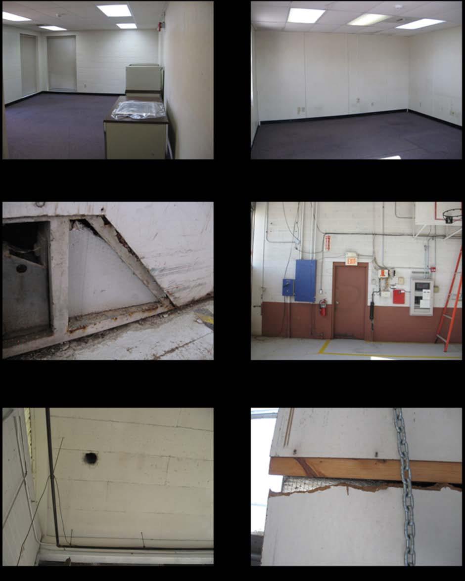
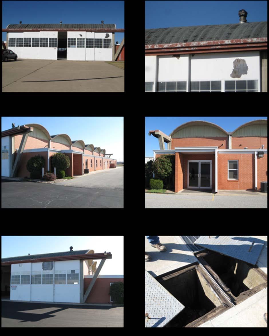
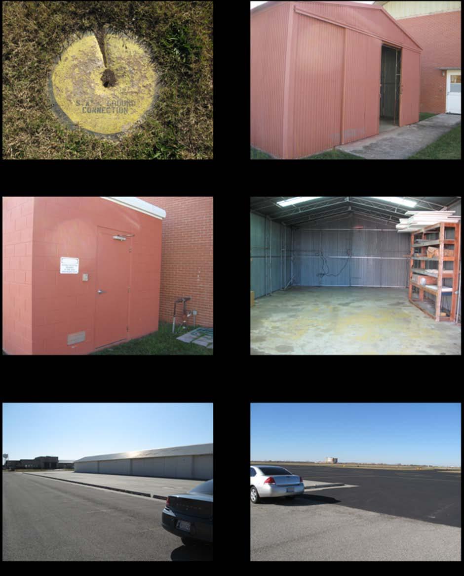
10 On May 16 th, 1998 the SE quarter of Section 24, Township 9N, Range 3W of the Indian Meridian the Oklahoma National Guard released, relinquished, and surrendered all of its right, title and interest in the premises to the Board of Regents for the University of Oklahoma. 3.2 Site and Vicinity Characterization The former was built in According to Cleveland County land records, the land for the building was leased by the State of Oklahoma on April 18, 1953, for benefit of the Oklahoma National Guard (see Appendix F). The subject property is on a small tract of land residing on leased property of approximately 10.1 acres in size. The subject property is located at 2232 Goddard Avenue bound by North Flood Avenue to the East, the City of Norman facilities to the Southeast, and the University of Oklahoma Max Westheimer Airport to the West and Southwest. The areas where the subject property and adjacent properties are located are best characterized by a facility owned by the City of Norman as well as airplane hangers and runways. A site vicinity map of the subject property and aerial photographs can be found in Appendix A and C, respectively. According to Kim Fairbanks, property manager for the University of Oklahoma the utilities that serve the subject property are the City of Norman and Oklahoma Gas and Electric (OG&E). The University of Oklahoma provides the water and recently replaced the water line to the southwest of the property. According to the Oklahoma Water Resources Board Water Information Mapping System, the subject property is served by the City of Norman. A review of the topographical map indicated that the surface elevation of the site is approximately 371 feet above mean sea level. The topographical gradient is to the south, toward the South Canadian River. This river is located approximately 4.0 miles due south of the site. The topographical map can be found in Appendix C. 3.3 Description of Structures, Roads, and Other Improvements The structure of the is in good condition. According to Christa Welch during a site visit (Ref. 6) there were visible signs of degradation, including old or missing ceiling tiles and damaged pipe insulation within the Hanger. There were broken windows on the Hanger doors as well as cracking and peeling window caulking. There was also evidence of flaking paint on the Hanger doors. On the floor of the Hanger s main area was a draining grate with standing water. Based on previous armories, it is thought that these types of grates or drains lead into the city sanitary sewage pipes, but at the time of this report that could not be confirmed. Roads surrounding the Armory are in good condition. All roads are constructed of asphalt pavement. Adjacent properties, which consist of a Norman Fire Station and the Oklahoma Department of Highway Patrol, are in good condition. 10
11 3.4 Owner, Property Manager, and Occupant Information The subject property is owned and occupied by the University of Oklahoma. The DEQ Site Cleanup Assistance Program (SCAP) is in charge of identifying environmental hazards and conducting the cleanup of the Armory. The Military Department transferred ownership of the armory to the University of Oklahoma prior to completion of remedial activities. 3.5 Information Reported by User Regarding Environmental Lien or Specialized Knowledge or Experience The property owner and/or representatives reported no environmental liens on the subject property, and had no specialized knowledge or experience regarding recognized environmental conditions. The DEQ conducted a search for environmental liens at the Cleveland County Courthouse. No environmental liens or use limitations were reported for the subject property. A search was conducted on the Oklahoma DEQ webpage (Ref. 21) IC database for current Brownfields projects. No current Brownfields projects were reported near the subject property. 3.6 Commonly Known or Reasonably Ascertainable Information Kim Fairbanks, property manager for the University of Oklahoma, had no exceptional knowledge of commonly known or reasonably ascertainable information within the local community about possible environmental conditions on the property. It is known within the community that the building functioned as a National Guard Hanger since it was constructed in 1960 until it was relinquished back to the University of Oklahoma in Valuation Reduction for Environmental Issues Valuation of the property is outside the scope of this assessment. A professional appraiser should be consulted to place a value on the property. 3.8 Current Use of the Property The building is currently being used for storage by the University of Oklahoma. The offices located along the west portion of the Hanger are used for additional storage with rooms containing shelving units. 3.9 Past Use of the Property Review of Aerial Photographs Historic aerial photographs were searched to view the changes to the property over time. Aerial photographs were obtained from the Department of Libraries (Ref. 7) and the DEQ GIS data viewer (Ref. 8) of archived and present-day photographs. Aerial photographs from 1940, 1995, 2005, 2008, and 2010 were 11
12 obtained. All these photographs are located chronologically in Appendix C. The following represents a summary of what was found at the subject property from each photograph aerial photograph The 1940 aerial photograph obtained from the Oklahoma Department of Libraries reveals the University of Oklahoma s Max Westheimer Airport and Airfield, but it does not depict the Armory Hanger. There is a grassy field in the area where the Armory Hanger will be built in 20 years. This picture is prior to the construction of Interstate aerial photograph The 1995 aerial photograph shows the subject property present with a distinct building just north of Goddard Avenue. To the east, there are three buildings and to the southeast is a complex of buildings and parking lots. To the north of the Hanger is a small landing strip for airplanes and helicopters. Further north of the landing strip is comprised of the University of Oklahoma Max Westheimer airfield. Goddard Avenue continues westbound and more buildings and hangers are visibly present until the road meets Lexington Street and turns south aerial photograph The 2005 aerial photograph shows the construction of a new building directly east of the subject property. The remaining areas seem to be unchanged from the 1995 aerial photograph aerial photograph The 2008 aerial photograph shows no changes to the adjacent areas of the subjected property from the 2005 aerial photograph. However, west of 24 th street which is less than a mile from the subject property retail development is occurring. The remaining areas were unchanged from the 2003 aerial photograph aerial photograph The 2010 aerial photograph shows the development occurring west of 24 th street. There have been several retail buildings constructed including the high rise Embassy Suites Hotel that had not been completed during the time frame of the 2008 aerial photograph. The remaining areas from the 2008 aerial photograph are unchanged Fire Insurance Maps Sanborn Fire Insurance maps were viewed and downloaded from the Oklahoma Department of Libraries website (Ref. 9). No Sanborn Maps of the subject property or adjoining properties were found. A general Sanborn Map of the City of Norman city limits and index from 1925 is located in Appendix C. 12
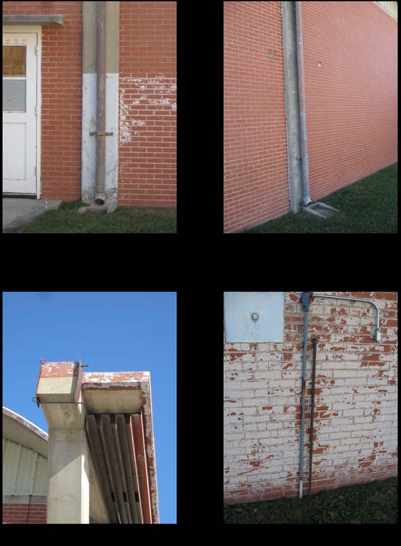
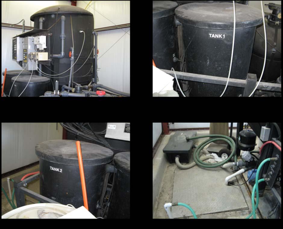
13 3.10 Current and Past Uses of Adjoining Properties During the site visit on the 18 th of November 2009, adjoining properties were observed to contain the following. Directly to the east of the Hanger is a brick building that houses an air compressor, a small chemical storage building, and an equipment storage used by the military. The adjacent property to the north belongs to the University of Oklahoma Max Westheimer Airport and is used for non-commercial aircraft. To the west of the Hanger is the main area of the airport including runways and tarmacs. To the south of the property and across Goddard Avenue the City of Norman has various facilities including a Norman Fire Station Environmental (Physical) Setting The DEQ reviewed several sources to obtain information on the physical setting of the subject property and its surrounding areas. These sources include: The United States Department of Agriculture Oklahoma County Soil Survey, Flood Insurance Maps, the Hydrologic Atlas Oklahoma Geological Survey, and the Federal Emergency Management Association. Review of the physical setting of the area is to evaluate the sensitivity of the hydrogeology to potential contamination from sources either on or near the site Surface Water Characteristics The topography of the area is relatively flat. The is located at a surface elevation of approximately 371 feet above mean sea level. The topographical gradient is to the south towards the South Canadian River. The South Canadian River is located approximately 4.0 miles south of the site. According to the Federal Emergency Management Association (FEMA), the structure lies in area X, outside the boundaries of a 0.2% annual flood (500 year flood event) (see Ref. 10). A map of this information is located in Appendix C Subsurface Geological Characterization According to the Soil Survey of Cleveland County, Oklahoma obtained from the United States Department of Agriculture (Ref. 11) the subject property consists mainly of Kirkland-Urbanland-Pawhuska complex soils with 0-3% slopes. Kirkland silt loam with 0-1% slopes comprises approximately 13.4% of the soil composition. Kirkland-Pawhuska with 0-5% slopes eroded (7.1%), Grainola- Ashport (6.1 %), Kirkland-Pawhuska with 0-5% slopes (2.1%), Renfrow-Huska with 3-5% slopes (0.8%), and Kingfisher-Ironmound complex with 1-5% slopes (0.2%), respectively, are all found within the general area of the Ground Water Characteristics The major groundwater aquifers in this area are the Garber-Wellington Aquifer and the Canadian River Aquifer. 13
14 The Oklahoma Water Resources Board (OWRB) and the United States Geological Survey (USGS) report the total area of the Garber-Wellington groundwater aquifer as square miles and the basin is comprised of bedrock. The Canadian River Aquifer as reported by OWRB and USGS state the total area for this aquifer is square miles. The Canadian River Aquifer consists mostly of alluvium and terrace deposits (see Ref. 12) Air Characteristics No air emissions were noticed at the subject property or the adjoining properties. Kim Fairbanks had no knowledge of any air emissions on the subject property (Ref. 6). Christa Welch spoke with the City of Norman utilities about the drainage problem on the south side of the property. They opened two hatches one of which had a large valve. These hatches allowed for drainage of the water off of the subject property. Prior to the hatches, water may have collected with an oily top layer and a slight hydrocarbon smell. Because this is a small airline hanger there is potential for fuel emissions if used for vehicle and aircraft storage. There is also a potential for asbestos emissions from suspect asbestos on the subject property. 4.0 RECORDS REVIEW A regulatory database search was conducted by the DEQ. This search included, at a minimum, those records and distances from the site dictated as appropriate in the ASTM standard. The DEQ performed a review of available federal and state databases to assess whether the subject property or proximate properties were listed as having environmental concerns, which could have an adverse impact on the subject property. The following provides a summary of the databases reviewed. 4.1 Federal National Priorities List (NPL) The Environmental Protection Agency (EPA) database was searched for NPL sites near the subject property within the ASTM s recommended search radius of one mile (Ref. 13). The subject property is not a listed NPL site. There are no NPL sites reported within a one-mile radius of the subject property. There is also an EPA database for Delisted NPL sites, which ASTM requires to be reported within ½ mile of the subject property (Ref. 14). No delisted NPL sites are within the ½ mile search radius. 4.2 Federal CERCLIS List The EPA database for Comprehensive Environmental Response, Compensation and Liability Act (CERCLA) Information Service (CERCLIS) was searched for active and 14
15 archived CERCLIS sites on and near the subject property (Ref. 15). The ASTM s recommended search radius of the subject property for both active and archived CERCLIS sites is ½ mile. No active CERCLIS sites were found within ½ mile of the subject property. 4.3 Federal RCRA CORRACTs List The EPA database for Resource Conservation and Recovery Act (RCRA) facilities subject to corrective action was searched within the ASTM s required minimum distance of one mile of the subject property (Ref. 16). No RCRA CORRACT facility was found within the one-mile radius of the subject property. 4.4 Federal RCRA non-corracts TSD List The EPA database for RCRA facilities not subject to corrective action was searched within the ASTM s required minimum distance of ½ mile of the subject property (Ref. 16). No RCRA non-corract Treatment, Storage and Disposal (TSD) sites are within the ½ mile radius of the subject property. 4.5 Federal RCRA Generators List The EPA RCRA Notifiers database was searched for RCRA generators within a one mile radius (Ref. 16). The required minimum search distance is the subject property and the adjoining properties. The subject property had one RCRA generator on site. The following is a table of the generators within a one mile radius. EPA ID Facility Address Generator status OKR Auto Accessories 3451 N. Flood Not listed OKD Energy Analysts Inc Priestley Ave No longer generating; still in business OKR Flair Body Works 1900 Industrial Small quantity generators OKR Former SW Nano Tech 2360 Industrial No longer generating; still in business OK Former US Aviation Wing 2232 N. Goddard Ave No longer generating; still in business One generator was found on site. The ID for this generator is OK and was formerly the US Aviation Wing. The generator is no longer in operation. A complete table of the RCRA generators is located in appendix E. 4.6 Federal ERNS List Emergency Response Notification system (ERNS) maintained by the National Response Center was searched for any hazardous substance releases or spills within the subject property (Ref. 17). ASTM requires a minimum search distance of property only when 15
16 identifying ERNS cases. No ERNS sites were reported within the property or the adjoining properties. 4.7 Federal Institutional Control/Engineering Control Registries There are no known Institutional Controls/Engineering Controls on the subject property according to the representatives of the subject property and a search of county land records. 4.8 State-Equivalent NPL The DEQ does not have a State-equivalent NPL database. Oklahoma does not have a State Superfund law to establish a State-equivalent NPL database. 4.9 State - Equivalent CERCLIS The DEQ does not have a State-equivalent CERCLIS database State Landfill and / or Solid Waste Disposal Sites The DEQ regulates landfills and solid waste disposal sites across the State of Oklahoma (Ref. 18). State landfills and solid waste disposal facilities were searched in the DEQ database within the ASTM required minimum distance ½ mile from the subject property. No permitted landfills or solid waste disposal facilities are located within the search distance of the subject property State Leaking UST List The Oklahoma Corporation Commission UST Notification Database was searched to locate any known leaking underground storage tanks (LUSTs) sites located within the ASTM s minimum search distance of a ½ mile of the subject property. No LUST sites were found within the ½ mile radius State Registered UST Sites The Oklahoma Corporation Commission UST Notification Database (Ref. 19) was searched to locate registered underground storage tanks (UST) located within the ASTM s minimum search distance of the subject property and its adjoining properties. Two registered USTs were found on site and nine registered USTs were found on adjoining properties. The Oklahoma Military Department and the Aviation Facility owned the two USTs on site. The following table lists the USTs and addresses found within ¼ mile radius of the site. Facility # Name Address Tanks Status LUST City of Norman 103 Congress 5 Inactive NO OK Military 1208 Thunderbird 2 Inactive NO 16
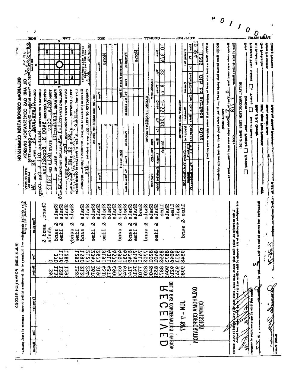
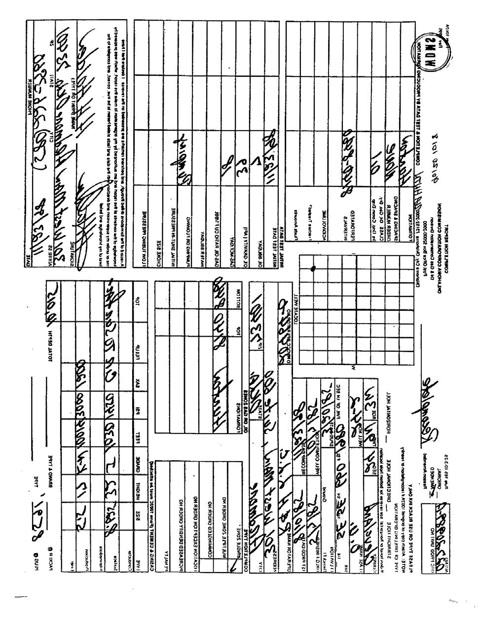
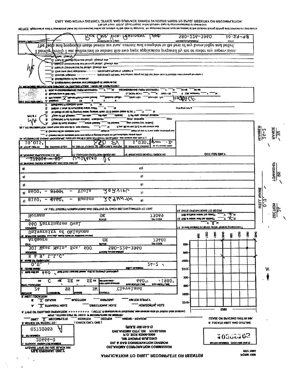
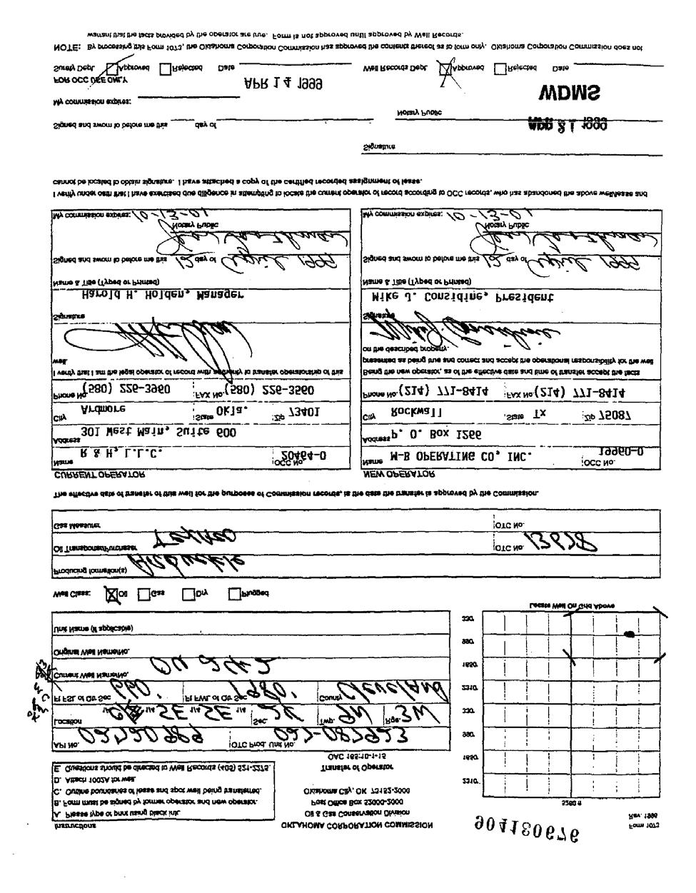
17 Aviation Facility 2232 Goddard 2 Inactive NO OK Military 2232 Goddard 1 Inactive NO The Airmen Inc 1948 Goddard 4 Inactive NO United Parcel Service 1950 Goddard 1 Inactive NO Westheimer Airport Davinci & Goddard 9 Inactive NO Fleet Management 1301 Davinci 2 Active NO Norman Batch Plant 2600 N. Flood 2 Active NO 4.13 State Institutional Control/Engineering Control Registries The State Institutional Control/Engineering Control Registry developed by the DEQ was searched for any Brownfield sites near the subject property. There are no Institutional Control/Engineering Controls in effect for this property (Ref. 21) State Voluntary Cleanup Sites The DEQ Voluntary Cleanup Program (VCP) database was searched for VCP sites within the required ASTM search distance of ½ mile of the (Ref. 20). No VCP sites are located on or within ½ mile of the subject property State Brownfield Sites The DEQ Brownfield database was searched for Brownfield sites within the required ASTM search distance of ½ mile of the (Ref. 21). No Brownfield sites were found within ½ mile of the Oil and Gas Records The DEQ determined that the subject property is located in the SE quarter of the NE ¼ NE ¼ of Section 24, Township 9 North, Range 3 West. The DEQ performed a search of oil and gas records from the Oklahoma Corporation Commission s oil and gas records database. The subject property is in an area where there is a history of oil and gas development. Oil and gas records were searched to record the known history of well development on this site. A search area consisted of the property as described from the legal locations above and the quarter, quarter, quarter sections directly adjacent and upgradient of the site. The following describes each well record found in these areas. Specific details of these wells are located in Appendix E. The Holden Energy Corporation had intent to drill two wells in Section 24, Township 9N, Range 3W. Specifically these wells are located at ¼ SE ¼ SE ¼ NE (well OU 24-1) and C ¼ SE ¼ SE (well OU 24-2). The drilling for well OU 24-1 began on November 15 th, 1982 and was completed on May 10 th, First production commenced on April 27 th, 1983 and recompleted on November 19 th, 1998 according to the Oklahoma Corporation Commission Oil and Gas 17
18 Conservation Division (Ref. 19, see Appendix E for documents). The following are target formations and depths: o Unconformity 7698 feet o Viola 8370 feet The drilling for well OU 24-2 began on March 20 th, 1985 and was completed on May 7 th, 1985 according to the Oklahoma Corporation Commission Oil and Gas Conservation Division (Ref. 19, see Appendix E for documents). The date of first production was August 10 th, The following are target formations and depths: o Hunton 8,140 feet o Viola 8600 feet 5.0 SITE RECONNAISSANCE AND INTERVIEWS 5.1 Methodology and Limiting Conditions A site reconnaissance of the property located at 2232 North Goddard Avenue, Norman, Oklahoma was performed on the 18 th of November Christa Welch of the DEQ met the property manager, Kim Fairbanks, to conduct a phase I assessment of the property (Ref. 6). Kim Fairbanks introduced Christa Welch to the site and answered questions to the best of her knowledge on the site. All areas of the building were observed noting any environmental conditions that might need additional investigation. The outside area of the property was walked through entirely for observations that might need additional investigation as well. 5.2 General Site conditions The property is composed of brick and is approximately 11,979 square feet. It was constructed in The building is occupied by the University of Oklahoma. The property surrounding the building consists of a paved tarmac to the north of the building and grass. A parking lot is to the south and west of the Hanger. The adjacent property to the north belongs to the University of Oklahoma Max Westheimer Airport and is used for non-commercial aircraft. Further south of the subject property across Goddard Avenue, the City of Norman has various facilities including a Norman Fire Station. Aboveground Storage Tanks (ASTs) The subject property does not have any ASTs. No ASTs were found on the adjacent properties during the site reconnaissance. Landfills and/or Dumping No landfills, dumping, or disturbed soil was found on the property. 18
19 Impoundments No impoundments were observed on the subject property. Monitoring Wells According to the Oklahoma Water Resources Board well search (Ref. 22) eight monitoring wells were found within one mile of the subject property. Specifically, six wells lie on University of Oklahoma property, but none lie on the subjected property. All six wells are down gradient of the. Disturbed and Stained Soils No stained soils were observed on the subject property. Seeps No seeps of any kind were observed on the subject property. Chemical Spills No evidence of possible chemical spills was observed on the subject property. Farm Waste No farm waste was observed on the subject property. Known Pesticide Misapplication No known pesticide misapplications were detected during the site visit or during the supportive research. Discharges and Runoff from Adjacent Property Affecting the Site Rainwater runs off to the east of the subject property. DEQ observed pooled water on the Hanger floor that may have been due to raining events. Petroleum Products and Oil and Natural Gas Exploration There is a history of oil and natural gas exploration in the area. A search of the Oklahoma Corporation Commission s oil and gas records database revealed two wells, one well on site and the other adjacent to the legal description of the property. Holden Energy Corporation and OU 24-2 wells were drilled in the mid 1980s. See Section
20 Asbestos Since many of the State armories were built before the 1970s, there is a high potential of finding asbestos containing materials, or ACM in the armory buildings. The U.S. began banning the use of asbestos in most building products in the 1970s due to studies confirming the harmful health effects caused by exposure to airborne asbestos. ACM may be found in the insulation wrapping of the heating pipes and/or heaters, roofing materials, ceiling tiles, window putty, mastic, and floor tiles. Floor tiles that are nine inches by nine inches have been found to regularly contain asbestos. Marshall Environmental Management, Inc. completed an asbestos inspection for the on May 7, In this inspection report asbestos containing floor tile and floor tile mastic were found in two of the west rooms. Asbestos was also found in the pipefitting insulation in one room. Lead The building most likely contains lead-based paint and lead dust. There is no indoor firing range in this building, so the lead dust is most likely due to deteriorated lead-based paint. Marshall Environmental Management, Inc. completed lead-based paint and leadladen dust inspection for the on May 7, Lead-based paint was found on the interior panels of the hanger doors as well as the exterior of the hanger doors, windows, and track wheels. Lead-laden dust was found on the main Hanger floor and in several rooms. Transformers/PCB Equipment There were no transformers observed around the subject property because of the airfield. Fluorescent lighting ballasts could potentially be present in the Hanger. At the time of this report it is unknown if fluorescent lighting ballasts were in existence in the Norman Hanger. 5.3 External Observations The external observations did not show any recognized environmental conditions. The area is composed of a paved parking lot along with grass vegetation covering the south portion of the site. The northern area is paved asphalt running east and west towards the airport tarmac. The area around the building is considered a commercial area used by the University of Oklahoma Max Westheimer Airport. Photographs of the external view of the site can be found in Appendix B. 5.4 Internal Observations The building is currently occupied by the University of Oklahoma and was last used by the Oklahoma Army National Guard to support the military mission. The building was constructed from brick in Before construction of the armory building the land was 20
21 owned by the Board of Regents for the University of Oklahoma and was vacant land on the Max Westheimer Airport. During the site visit on November 18, 2009 small pools of standing water were observed on the main floor of the Hanger. Photographs of the internal view of the site can be found in Appendix B. 5.5 Interviews Kim Fairbanks, property manager, gave a tour of the and provided historical and environmental information of the site. She was not aware of any present environmental concerns of the property or adjacent properties. Below is the information obtained from Kim Fairbanks (Appendix D): There has been no industrial use of the subject property or surrounding areas in the past. No known chemical spills on the property. No cisterns, above ground storage tanks, or impoundments have been present in or on the property. The Oklahoma Military Department did have radiators present on site. There were 2-3 radiators present. It was suggested that oil and gas wells had been present in a nearby area in the past but not currently. Hazardous materials may include lead based paint, lead dust and asbestos. The University of Oklahoma would like to use the building for storage and or recreational uses. 6.0 FINDINGS Summarized below are the major findings from this Targeted Brownfield Assessment and DEQ s recommendations. The major findings of the highest environmental concern are presented first. The former was built in The land for the Hanger was leased by the University of Oklahoma to the State of Oklahoma on April 18, 1953 for the benefit of the Oklahoma National Guard. The subject property is currently owned by the University of Oklahoma. After all remediation activities have taken place and a notice of remediation and easement has been filed in the Cleveland County Courthouse, the deed to the property will revert to the University of Oklahoma. The building is contaminated with lead dust, lead-based paint, and asbestos. The Oklahoma Department of Environmental Quality Site Cleanup Assistance Program plans to cleanup any lead and asbestos contamination on the subject property and properly dispose of all associated waste. The lead and asbestos contamination in the building constitutes a recognized environmental condition (REC). Adjoining properties consist of the City of Norman, a Norman Fire Department Station, and the University of Oklahoma Max Westheimer Airport. Historical aerial photographs show developed retail and non-commercial property around the. 21
22 Sanborn Fire Insurance maps did not show the vacant land of the subjected property between the years 1933 and No National Priority List (NPL), delisted NPL sites, Resource Conservation and Recovery Act (RCRA) non-corrective action sites (CORRACTS) treatment, storage, and disposal (TSD) listings, Emergency Response Notification System (ERNS) list, Institutional Controls/Engineering Controls, or State landfills and/or solid waste disposal sites were found on the subject property or within the ASTM recommended search radii. No RCRA generators, Voluntary Cleanup (VCP) sites, or Brownfield sites were found on the subject property. No active or archived Comprehensive Environmental Response, Compensation, and Liability Information Search (CERCLIS) site listings were found. The subject property is on the DEQ Site Cleanup Assistance Program (SCAP) list for cleanup of lead and asbestos contamination. There were five RCRA generators listed within one mile of the subject property. Nine underground storage tank sites were found within a ½ mile radius and nine underground storage tank sites within a ¼ mile radius of the subject property. There are two inactive USTs and no LUSTs on site. Two of the USTs were owned by the aviation facility and three were owned by the Oklahoma Military Department. It is unknown if those tanks have been removed. Oil and gas development was found in the OCC oil and gas records for the quarter, quarter, quarter sections directly above and upgradient of the site. 7.0 OPINION AND RECOMMENDATIONS Due to the past use of the property and contamination found on the subject property, the environmental professionals working on this site believe that cleanup of lead and asbestos is warranted. Several findings mentioned in Section 6.0 of this report support this opinion. No archived RCRA CORRACT site listings, VCP sites, CERCLIS sites, and Brownfield sites were found within the ASTM recommended search radii, indicating a low potential of impact to the subject property. Eight RCRA generators were found within one mile of the subject property. DEQ feels that there is a low potential impact to the subject property from these facilities. 8.0 DATA GAPS No tribal information was obtained for this assessment. No tax records, city directories, or zoning records were reviewed for this report. The Limited Environmental Baseline Assessment (LEBA) had not been completed at the time this TBA was conducted. However, this did not affect the ability of the DEQ to make a recommendation on the subject property. 22
23 9.0 CONCLUSIONS DEQ has performed a Phase I Environmental Site Assessment in conformance with the scope and limitations of ASTM Practice E of the former located at 2232 Goddard Avenue,. Any exceptions to, or deletions from, this practice are described in Section [10.0] of this report. This assessment has revealed no evidence of recognized conditions in connection with the property except for the following: lead dust, lead-based paint, and asbestos contamination throughout the building. The information provided in this assessment is to assist the University of Oklahoma in its revitalization planning as well as meet the All Appropriate Inquiry requirement of the landowner liability protections under the Comprehensive Environmental Response, Compensation and Liability Act (CERCLA, also Superfund Ref. 2), as provided in the Small Business Relief and Brownfields Revitalization Act of 2002 (Public Law , Subtitle B Ref. 3) ADDITIONAL SERVICES Additional services provided in this Phase I Targeted Brownfield Assessment include asbestos, lead-based paint, and lead dust sampling by DEQ and its contractors DEVIATIONS The following deviations from ASTM Practice E occur in this Phase I Targeted Brownfield Assessment. Asbestos and lead paint were sampled and the corresponding results were included in this report. Normally, sampling is not included in a Phase I Environmental Assessment, but it was in this case. No tax records, city directories, or zoning records were reviewed for this report. 23
24 12.0 REFERENCES 1. U.S. Environmental Protection Agency. (2008). Oklahoma Brownfields Assistance Agreement. (No #RP ). Unpublished Document. State of Oklahoma: Oklahoma City, Oklahoma. 2. U.S. Environmental Protection Agency. (1980). Comprehensive Environmental Response, Compensation, and Liability Act. (Public Law ). Washington, DC: U.S. Government Printing Office. 3. U.S. Environmental Protection Agency. (2002). Small Business Liability Relief and Brownfields Revitalization Act. (Public Law , Subtitle B). Washington, DC: U.S. Government Printing Office. 4. ASTM International. (2005). Water and Environmental Technology: Phase I Environmental Site Assessment E Baltimore, Maryland. 5. Cleveland County Courthouse records search. DEQ site visit May 13 th Christa Welch, Oklahoma Department of Environmental Quality, interview notes from the initial site visit to the with Kim Fairbanks, the University of Oklahoma property manager. 18 November Oklahoma Department of Libraries aerial photo search. DEQ site visit May 5 th Oklahoma Department of Environmental Quality online GIS Data Viewer. Accessed 11 April Sanborn Fire Insurance Maps. Oklahoma Department of Libraries. Accessed 5 May Oklahoma Water Resources Board (OWRB) water information mapping system (WIMS). Conducted a search of the major aquifers and the minor groundwater basins in Norman, Oklahoma. Accessed 30 March EPA NPL list: Delisted NPL sites database: CERCLIS current and archived sites: Federal Emergency Management Association (FEMA). Accessed 11 April
25 15. United States Department of Agriculture subsurface geological characterization and soil survey. Found at: Accessed on 30 March RCRA database: Emergency Response Notification System: State Landfill site list: Oklahoma Corporation Commission Oil and Gas Conservation Division. Jim Thorpe Building, Oklahoma City, Oklahoma. DEQ site visit May 5 th Oklahoma Department of Environmental Quality voluntary cleanup site database. Accessed 30 March Oklahoma Department of Environmental Quality State Brownfield Site database. Accessed 30 March Oklahoma Water Resources Board monitoring well search. Accessed 30 March
26 13.0 APPENDICES Appendix A Appendix B Appendix C Appendix D Appendix E Appendix F Appendix G Site (Vicinity) Maps Site Photographs Historical Research Documentation Aerial Photographs Topographical Map Fire Insurance Sanborn Map Flood Insurance Map (FEMA) Floor Plan Log Book and Interview Documentation Oklahoma Corporation Commission Oil and Gas Records Underground Storage Tank Records Cleveland County Records and Deeds Qualifications of Environmental Professional 26
27 Appendix A Site (Vicinity) Maps 27
")
28 Figure 1. Site (Vicinity) Map 28
29 Figure 2. Site (Vicinity) Map 29
30 Appendix B Site Photographs 30


31 Photos taken on November 18 th, 2009 by C. Welch 31
32 32
33 33
34 34

35 35
36 36
37 Appendix C Historical Research Documentation 37
38 Aerial Photographs 38

39 Aerial 1943 Photograph 39

40 Aerial 1995 Photograph 40

41 Aerial 2005 Photograph 41

42 Aerial 2008 Photograph 42

43 Aerial 2010 Photograph 43
44 Topographical Map 44

45 Figure 1. Topographical Map 45
46 Fire Insurance Sanborn Maps 46

47 Figure 1. Sanborn Map (October 1925) Oct Apr. 1944, Sheet 1&CCSI=4117n 47
48 Flood Insurance Map (FEMA) 48
,")
49 Figure 1. Federal Emergency Management Association (FEMA), Flood Insurance Map 100 year flood risk 49
50 Floor Plan 50

51 Figure 1. Floor Plan 51
52 Appendix D Log Book and Interview Documentation 52
53 Log Book, Interview Documentation, and Notes of Site Visitation by C. Welch 53
54 54
55 55
56 56
57 57
58 58
59 Appendix E Federal RCRA Generators List 59
60 60
61 61
62 62
63 63
64 64
65 65
66 66
67 67
68 68
69 69
70 70
71 Oklahoma Corporation Commission Records 71

72 Oil and Gas Records Documents 72
73 73
74 74
75 75
76 76
77 77

78 78
79 79
80 80
81 81
82 82
83 83
84 84
85 85
86 86
87 87
88 88
89 89
90 90
Environmental Audit Standards
 Environmental Audit Standards Lender requires an acceptable Phase I Environmental Audit Report, directed to Lender and historical in nature, which is to be prepared in accordance with the standards set
PHASE I ENVIRONMENTAL SITE ASSESSMENT
 PHASE I ENVIRONMENTAL SITE ASSESSMENT ACME Gas 55 Garden Street Columbus, Ohio, 45123 Prepared for ACME Oil & Gas Ltd. Prepared by GAEA Environmental Services 87 Garden Street Whitby, Ontario L1N 9E7 November
Hazardous Materials in Project Development Additional Guidance
 Hazardous Materials in Project Development Additional Guidance Contents:...2 AASHTO Guidance...3 USDOT Brownfields Guidance...4 ASTM Standard Practices...6 Hazardous Materials in Project Development 1
ENVIRONMENTAL SITE ASSESSMENT (AAI COMPLIANT PHASE I)
") ENVIRONMENTAL SITE ASSESSMENT (AAI COMPLIANT PHASE I) IPP.MORELAND AVENUE ASSEMBLAGE 785-793 MORELAND AVENUE ATLANTA, GEORGIA, 30316 ONE GROUP PROJECT #A6092 JANUARY 28, 2008 PREPARED FOR: FAIRVIEW COMMERCIAL
ENVIRONMENTAL SITE ASSESSMENT (AAI COMPLIANT PHASE I) IPP.MORELAND AVENUE ASSEMBLAGE 785-793 MORELAND AVENUE ATLANTA, GEORGIA, 30316 ONE GROUP PROJECT #A6092 JANUARY 28, 2008 PREPARED FOR: FAIRVIEW COMMERCIAL
Due Diligence & Environmental Compliance Issues for Tribal Energy Projects: Hazardous Waste
 Due Diligence & Environmental Compliance Issues for Tribal Energy Projects: Law Seminars International Seattle, WA October 23, 2007 Connie Sue Manos Martin Hazardous Waste Overview Environmental Due Diligence:
PHASE I ENVIRONMENTAL ENGINEERING PHASE I REPORT 3264 PREPARED FOR: Mark Hopkins. Liberty Real Estate, LLC. 741 North State Road.
 PHASE I ENVIRONMENTAL ENGINEERING PHASE I REPORT 3264 PREPARED FOR: Mark Hopkins Liberty Real Estate, LLC 741 North State Road Salem, Utah 84653 May 25, 2012 SITE LOCATION Hawthorn Mobile Home Park 10682
PHASE I ENVIRONMENTAL SITE ASSESSMENT
 PHASE I ENVIRONMENTAL SITE ASSESSMENT ST. MALACHY PROPERTY, BROWNSBURG HENDRICKS COUNTY, INDIANA Terra Project No. 13-013 Environmental Audit Report Privileged Document PREPARED FOR: Town of Brownsburg
Assessment. Guidance CLEANUP. Liability Release. Petroleum Brownfields Eligibility Letter Remediation Oversight. Project Endorsement
 BROWNFIELD PROGRAM Guidance FOR SITES CONTAMINATED BY OLD OIL AND GAS EXPLORATION AND PRODUCTION ACTIVITIES, PETROLEUM STORAGE TANKS, AND PIPELINES. Assessment Petroleum Brownfields Eligibility Letter
Phase I Environmental Site Assessment Update Memorandum Vacant Property 1585 Santa Clara Avenue Santa Ana, California 92507
 March 1, 2011 Mr. Vincent C. Fregoso, AICP City of Santa Ana 20 Civic Center Plaza Santa Ana, CA 92702 Re: Phase I Environmental Site Assessment Update Memorandum Vacant Property 1585 Santa Clara Avenue
PHASE I ENVIRONMENTAL SITE ASSESSMENT REPORT 3.3-ACRE ECKENRODE PROPERTY WARWICK TOWNSHIP, TUSCARAWAS COUNTY, OHIO. Prepared for: OHIOLAND, LLC
 PHASE I ENVIRONMENTAL SITE ASSESSMENT REPORT 3.3-ACRE ECKENRODE PROPERTY WARWICK TOWNSHIP, TUSCARAWAS COUNTY, OHIO Prepared for: OHIOLAND, LLC Prepared by: CIVIL & ENVIRONMENTAL CONSULTANTS, INC. COLUMBUS,
Change is in the air with regard. feature
 em feature Amy L. Edwards is a partner in the law firm of Holland & Knight LLP, Washington, DC, where she co-chairs the firm s national environmental team. Sarah C. Smith is an associate at Holland & Knight.
PHASE I ENVIRONMENTAL SITE ASSESSMENT 1724 VINTON STREET & 2702 SOUTH 18 TH STREET OMAHA, DOUGLAS COUNTY, NEBRASKA
 PHASE I ENVIRONMENTAL SITE ASSESSMENT 1724 VINTON STREET & 2702 SOUTH 18 TH STREET OMAHA, DOUGLAS COUNTY, NEBRASKA Prepared for: The Estate of George W. Murray & the Omaha Brownfields Coalition Benesch
Phase I Environmental Site Assessments for Corridors
 Phase I Environmental Site Assessments for Corridors Prepared by: Kimberly Perkins and Jill Biesma 1 Environmental Advisors and Engineers 19211 W. 64 th Terrace, Shawnee, KS 66218 (913) 599-4326 Goal Of
DUE DILIGENCE. Presented at. Lydia Work, Senior Chemist Licensed Remediation Specialist Triad Engineering, Inc.
 DUE DILIGENCE Presented at Lydia Work, Senior Chemist Licensed Remediation Specialist Triad Engineering, Inc. due dil i gence appropriate carefulness: the degree of care that a prudent person would exercise,
The University of Texas System Systemwide Policy. Policy: UTS Title. Environmental Review for Acquisition of Real Property. 2.
 1. Title 2. Policy Environmental Review for Acquisition of Real Property Sec. 1 Sec. 2 Policy Statement. It is the policy of The University of Texas System to minimize its potential for exposure to claims
DRAFT - Subject to Change. Cathedral Building 212 North Ash Street Crookston, Minnesota. Prepared For. Project FA June 29, 2011
 DRAFT Phase I Environmental Site Assessment Cathedral Building 212 North Ash Street Crookston, Minnesota Prepared For Braun Intertec Corporation Ms. Kay Hegge Prairie Skyline Foundation 27048 310th Street
Proposed Laurel 2 Solar Facility Jessup Road at Vaughn & Diehl Roads Imperial County, California
 Phase I ESA Report Proposed Laurel 2 Solar Facility Jessup Road at Vaughn & Diehl Roads Imperial County, California Prepared for: 9FI 8ME, LLC 221 Sutter Street, 6 th Floor San Francisco, CA 9418 Prepared
Voluntary standard; accepted by USEPA to comply with AAI rule. 2. Regulatory/Developmental History
 This table summarizes some of the primary differences between the New Jersey Department of Environmental Protection (NJDEP) Preliminary Assessment Report (PAR), pursuant to the April 2013 NJDEP Site Remediation
New Environmental Diligence Standards for All Appropriate Inquiries (AAI)
") New Environmental Diligence Standards for All Appropriate Inquiries (AAI) (a live interactive 90-Minute Teleconference Program) Peter Murphy 1050 Connecticut Ave., N.W. Washington, D.C. 20036 pmurphy@gibsondunn.com
New Environmental Diligence Standards for All Appropriate Inquiries (AAI) (a live interactive 90-Minute Teleconference Program) Peter Murphy 1050 Connecticut Ave., N.W. Washington, D.C. 20036 pmurphy@gibsondunn.com
PHASE I ENVIRONMENTAL SITE ASSESSMENT 904, 911 & 1007 South 20 th Street OMAHA, DOUGLAS COUNTY, NEBRASKA
 PHASE I ENVIRONMENTAL SITE ASSESSMENT 904, 911 & 1007 South 20 th Street OMAHA, DOUGLAS COUNTY, NEBRASKA Prepared for: J & C Snelling Properties LLC Benesch Project No. 00120137.00 March 2013 Prepared
ENVIRONMENTAL DISCLOSURE FOR TRANSFER OF REAL PROPERTY (IC ) State Form (R / 1-07) Indiana Department of Environmental Management
 State Form (R / 1-07) Indiana Department of Environmental Management") ENVIRONMENTAL DISCLOSURE FOR TRANSFER OF REAL PROPERTY (IC 13-25-3-7.5) State Form 52653 (R / 1-07) Indiana Department of Environmental Management A WARNING TO THE PARTIES TO A TRANSFER OF PROPERTY: The
ENVIRONMENTAL DISCLOSURE FOR TRANSFER OF REAL PROPERTY (IC 13-25-3-7.5) State Form 52653 (R / 1-07) Indiana Department of Environmental Management A WARNING TO THE PARTIES TO A TRANSFER OF PROPERTY: The
BROWNFIELDS Connecticut All Grantee Meeting July Getting the most out of All Appropriate Inquiries (AAI)
") BROWNFIELDS Connecticut All Grantee Meeting July 11 2012 Getting the most out of All Appropriate Inquiries (AAI) 1 AAI in Perspective All Appropriate Inquiries often is a critical step in a continuum of
BROWNFIELDS Connecticut All Grantee Meeting July 11 2012 Getting the most out of All Appropriate Inquiries (AAI) 1 AAI in Perspective All Appropriate Inquiries often is a critical step in a continuum of
Phase I Environmental Site Assessment Phase I Environmental Site Assessment. Siena Lakes Site Naples, Collier County, Florida
 `` Phase I Environmental Site Assessment Phase I Environmental Site Assessment Siena Lakes Site Naples, Collier County, Florida Parcel ID Nos. 00235960009, 00236000007, 00235560001, 855 NW State 00235520009
Standard Practice for Environmental Site Assessments: Phase I Environmental Site Assessment Process 1
 Designation: E1527 13 Standard Practice for Environmental Site Assessments: Phase I Environmental Site Assessment Process 1 This standard is issued under the fixed designation E1527; the number immediately
1976 Fargo, ND City Directory - R.L. Polk & Co.
 1986 Fargo, ND City Directory - R.L. Polk & Co. 1981 Fargo, ND City Directory - R.L. Polk & Co. 1976 Fargo, ND City Directory - R.L. Polk & Co. 1971 Fargo, ND Directory - R.L. Polk & Co. 1971 Fargo, ND
Technical Information Paper No
 Environmental Condition of Property (ECOP) Investigations Technical Information Paper No. 38-001-0312 PURPOSE. To provide information on ECOP investigations for Federal real property transactions and military
In previous editions of Environment and the
 environment and the appraiser The EPA s Proposed All Appropriate Inquiries Rule and the Appraisal of Contaminated Properties by Thomas O. Jackson, PhD, MAI In previous editions of Environment and the Appraiser,
Environmental Due Diligence
 2017 NJ Land Conservation Rally Environmental Due Diligence Stephen Kehayes Michelle Slosberg Peter Sorge, LSRP 1. Introduction 2. Due Diligence Process 3. Potential Problems 4. Investigation 5. Regulatory
EPA s All Appropriate Inquiry Rule: When is Enough, Enough?
 EPA s All Appropriate Inquiry Rule: When is Enough, Enough? JANE KIMBALL WARREN McCarter & English LLP, Hartford, CT In January 2002, CERCLA was amended to provide liability protection for certain landowners
ENVIRONMENTAL DUE DILIGENCE
 ENVIRONMENTAL DUE DILIGENCE Developing Solar on Landfills & Brownfields June 12-13, 2017 Chicago, Illinois Matthew E. Cohn Greensfelder Hemker & Gale, P.C. 200 West Madison Street Suite 3300 Chicago, Illinois
PHASE I ENVIRONMENTAL SITE ASSESSMENT AGGREGATE PRODUCTION ASSOCIATES PARCEL 2623 CENTER STREET OMAHA, DOUGLAS COUNTY, NEBRASKA
 PHASE I ENVIRONMENTAL SITE ASSESSMENT AGGREGATE PRODUCTION ASSOCIATES PARCEL 2623 CENTER STREET OMAHA, DOUGLAS COUNTY, NEBRASKA Prepared for: Aggregate Production Associates, Inc. & the Omaha Brownfields
Environmental Questionnaire
 SBA Loan Number: Environmental Questionnaire Applicant Name: of Site Visit: Name/Title of Person Doing Site Visit: Site Name or Business Name: Site Street Address: City, State, Postal Code: County: Site
BOARD OF REGENTS BRIEFING PAPER. 1. Agenda Item Title: Acquisition of Real Property located at 182 E. 9th Street, Reno NV
 BOARD OF REGENTS BRIEFING PAPER 1. Agenda Item Title: Acquisition of Real Property located at 182 E. 9th Street, Reno NV Meeting Date: September 5 & 6, 2013 2. BACKGROUND & POLICY CONTEXT OF ISSUE: Location
Managing Environmental Risks
 Managing Environmental Risks Presented by: Jeff Civins Mary Mendoza November 4, 2014 Agenda Basic Principles Tools for managing environmental risks Environmental due diligence Contractual Extra-contractual
PHASE I ENVIRONMENTAL SITE ASSESSMENT AXLES AND GEARS TRUCK PARTS WAREHOUSE 4808 SOUTH 26 TH STREET OMAHA, DOUGLAS COUNTY, NEBRASKA
 PHASE I ENVIRONMENTAL SITE ASSESSMENT AXLES AND GEARS TRUCK PARTS WAREHOUSE 4808 SOUTH 26 TH STREET OMAHA, DOUGLAS COUNTY, NEBRASKA Prepared for: Axles and Gears, Inc. & the Omaha Brownfields Coalition
FINDING OF SUITABILITY TO TRANSFER NAVAL RESERVE CENTER DULUTH, MINNESOTA
 FINDING OF SUITABILITY TO TRANSFER NAVAL RESERVE CENTER DULUTH, MINNESOTA Prepared by: Department of the Navy Base Realignment and Closure Program Management Office Northeast 4911 S. Broad Street Philadelphia,
DRAFT FINAL FINDING OF SUITABILITY TO TRANSFER (FOST) Little Patuxent River Parcel. October 16, 2013
 Little Patuxent River Parcel. October 16, 2013") DRAFT FINAL FINDING OF SUITABILITY TO TRANSFER (FOST) Little Patuxent River Parcel October 16, 2013 1. PURPOSE The purpose of this Finding of Suitability to Transfer (FOST) is to document the environmental
DRAFT FINAL FINDING OF SUITABILITY TO TRANSFER (FOST) Little Patuxent River Parcel October 16, 2013 1. PURPOSE The purpose of this Finding of Suitability to Transfer (FOST) is to document the environmental
ENVIRONMENTAL QUESTIONNAIRE AND DISCLOSURE STATEMENT
 ENVIRONMENTAL QUESTIONNAIRE AND DISCLOSURE STATEMENT The purpose of this questionnaire is to provide information about the past and present ownership and uses of the real property upon which lender will
Minnesota Pollution Control Agency Voluntary Investigation and Cleanup
 Minnesota Pollution Control Agency Voluntary Investigation and Cleanup Summary of Applicable Laws 1.0 Introduction Guidance Document #3 Over the past few years, the Minnesota Superfund law, known as the
PHASE I ENVIRONMENTAL SITE ASSESSMENT SOUTH OMAHA TERMINAL WAREHOUSE 4913 SOUTH 27 th STREET OMAHA, DOUGLAS COUNTY, NEBRASKA
 PHASE I ENVIRONMENTAL SITE ASSESSMENT SOUTH OMAHA TERMINAL WAREHOUSE 4913 SOUTH 27 th STREET OMAHA, DOUGLAS COUNTY, NEBRASKA Prepared for: South Omaha Terminal Warehouse & the Omaha Brownfields Coalition
New Phase I Requirements for Real Estate Transactions: Implications of the New All Appropriate Inquiries Rule
 New Phase I Requirements for Real Estate Transactions: Implications of the New All Appropriate Inquiries Rule Helen Currie Foster Graves, Dougherty, Hearon & Moody, P.C. 1 State Bar of Texas 28 th Annual
The Boeing Company On-Site Environment, Health and Safety Supplemental Provisions (SP4)
") THE CONTRACT WITH THE BOEING COMPANY is supplemented by the following additional clauses: 1.0 General. 1.1 In the event Seller or Seller s subcontractors or suppliers perform any On-Site Work, these additional
THE CONTRACT WITH THE BOEING COMPANY is supplemented by the following additional clauses: 1.0 General. 1.1 In the event Seller or Seller s subcontractors or suppliers perform any On-Site Work, these additional
Different Levels of Environmental Site Assessment and the Benefits to M&A Due Diligence
 Different Levels of Environmental Site Assessment and the Benefits to M&A Due Diligence A White Paper by Dennis Papa, PE, BCEE, Principal of dpstudio environmental consulting & design LLC November 2016
PHASE I ENVIRONMENTAL SITE ASSESSMENT
 PHASE I ENVIRONMENTAL SITE ASSESSMENT SARASOTA CENTER LOTS 141, 1571, 161, AND 515 SARASOTA CENTER BLVD ENGLEWOOD, FLORIDA 34224 SEPTEMBER 21, 212 NOVA PROJECT NO. E12 3583 Leaders in Environmental and
Highlights of USEPA All Appropriate Inquiries (AAI) Final Rule and Revised ASTM Phase I Environmental Site Assessment
 Final Rule and Revised ASTM Phase I Environmental Site Assessment") chapter 9b Highlights of USEPA All Appropriate Inquiries (AAI) Final Rule and Revised ASTM Phase I Environmental Site Assessment Barry A. Cik, PE, CP, DEE, QEP, CHMM, REM Chief Engineer G.E.M. Testing
chapter 9b Highlights of USEPA All Appropriate Inquiries (AAI) Final Rule and Revised ASTM Phase I Environmental Site Assessment Barry A. Cik, PE, CP, DEE, QEP, CHMM, REM Chief Engineer G.E.M. Testing
Mitigating Risk Through Environmental Due Diligence in California Real Estate Deals
 Mitigating Risk Through Environmental Due Diligence in California Real Estate Deals Kevin C. Mayer Harmon L. (Monty) Cooper Crowell & Moring 1 Outline Why Environmental Due Diligence? I. Purpose II. Roles
Phase I ESAs and the USEPA's All Appropriate Inquiry Final Rule
 Page 1 of 8 Phase I ESAs and the USEPA's All Appropriate Inquiry Final Rule An Electronic Newsletter of EEA's Environmental Consulting Activities Spring 2007 EEA, Inc. 55 Hilton Avenue, Garden City, New
FACT SHEET Brownfields Cleanup Program (BCP) KEY DEFINITIONS (see also ECL )
 KEY DEFINITIONS (see also ECL )") KEY DEFINITIONS (see also ECL 27-1405) Brownfield A Brownfield is any real property where redevelopment or re-use may be complicated by the presence or potential presence of a hazardous waste, petroleum,
KEY DEFINITIONS (see also ECL 27-1405) Brownfield A Brownfield is any real property where redevelopment or re-use may be complicated by the presence or potential presence of a hazardous waste, petroleum,
CITY OF VAUGHAN POLICY AND PROCEDURES FOR DEALING WITH CONTAMINATED OR POTENTIALLY CONTAMINATED SITES
 CITY OF VAUGHAN POLICY AND PROCEDURES FOR DEALING WITH CONTAMINATED OR POTENTIALLY CONTAMINATED SITES MAY 2001 This Report should be read in conjunction with the City of Vaughan BACKGROUND REPORT ON POLICY
July 1, 2017 HAZARDOUS SITE INVENTORY Environmental Protection Division Georgia Department of Natural Resources
 July 1, 2017 HAZARDOUS SITE INVENTORY Environmental Protection Division Georgia Department of Natural Resources HSI INTRO -i- July 1, 2017 INTRODUCTION TO THE HAZARDOUS SITE INVENTORY The purpose of this
C O U N T Y F A R M L E A S E
 Prepared by: Timothy R. Kenyon, Union County Attorney, Union County Courthouse, Creston, Iowa 641.782.1730 C O U N T Y F A R M L E A S E Recorder s Cover Sheet Return Document To: Grantors: Timothy R.
Tiered Environmental Review Format (2017)
") Tiered Environmental Review Format (2017) This tiered review format [per 24CFR 58.15] is designed to be used for activities that are categorically excluded [per 24CFR 58.35(a)] subject to the laws and
Tiered Environmental Review Format (2017) This tiered review format [per 24CFR 58.15] is designed to be used for activities that are categorically excluded [per 24CFR 58.35(a)] subject to the laws and
Limited Environmental Due Diligence: Transaction Screen. McCampbell Property San Patricio County
 Limited Environmental Due Diligence: Transaction Screen McCampbell Property San Patricio County 0 LAN_McCampbellProperties_Xstrategic_November,2017 LIMITED ENVIRONMENTAL DUE DILIGENCE Executive Summary
CERCLA AMENDMENT CREATES NEW EXEMPTIONS AND DEFENSES
 By Jay A. Jaffe and Thomas F. Quinn CERCLA AMENDMENT CREATES NEW EXEMPTIONS AND DEFENSES PROTECTS AGAINST LIABILITY FOR CLEANUP COSTS, ENCOURAGES REDEVELOPMENT OF BROWNFIELDS The Small Business Liability
Petroleum Brownfields: Oneida s Experience
 Petroleum Brownfields: Oneida s Experience Defining Challenges and Exploring Opportunities 1 Outline Purpose and Goals Oneida Reservation Facts Environmental Regulatory Challenges Tribal Environmental
Sustainable development for the future of Arkansas
 Sustainable development for the future of Arkansas The Brownfields Program Encourages the clean up and reuse of abandoned or underutilized properties. What is a Brownfield? Real Property where Expansion
Broker. Environmental Concerns Affecting Real Estate Transactions. Chapter 17. Copyright Gold Coast Schools 1
 Broker Chapter 17 Environmental Concerns Affecting Real Estate Transactions Copyright Gold Coast Schools 1 Learning Objectives Define potentially responsible person List the criteria for the innocent landowner
Real Estate Environmental Questionnaire and Disclosure Statement
 Real Estate Environmental Questionnaire and Disclosure Statement The following pages comprise an Environmental Questionnaire and Disclosure Statement which must be completed by the loan applicant before
October 29, 2013 Florida Brownfields Association Conference, Orlando
 Site Inventories October 29, 2013 Florida Brownfields Association Conference, Orlando Andrew M. Lawn, M.S., P.G. Principal Hydrogeologist Holden Heights Areas HSW & Orange County Environmental Protection
PHASE I ENVIRONMENTAL SITE ASSESSMENT Bluff City Boulevard Elgin, Illinois ETS Project No A. Prepared for:
 PHASE I ENVIRONMENTAL SITE ASSESSMENT 366-368 Bluff City Boulevard Elgin, Illinois 60123 ETS Project No. 09-0243A Prepared for: Ms. Sarah Kaminski Elgin State Bank 1001 South Randall Road Elgin, Illinois
Information compiled by: Crossett Economic Development Foundation 125 Main Street, Crossett, AR (870)
") Information compiled by: Crossett Economic Development Foundation 125 Main Street, Crossett, AR 71635 (870) 364-8745 mike@cityofcrossett.net www.considercrossett.net General Information Location of Crossett,
Information compiled by: Crossett Economic Development Foundation 125 Main Street, Crossett, AR 71635 (870) 364-8745 mike@cityofcrossett.net www.considercrossett.net General Information Location of Crossett,
(b) The location of principal and accessory buildings on the lot and the relationship of each structure to the other.
 The location of principal and accessory buildings on the lot and the relationship of each structure to the other.") ARTICLE XIX SITE PLAN Sec. 20-1900 Site Plan Review Procedure - Intent The site plan review procedures are instituted to provide an opportunity for the Township Planning Commission to review the proposed
ARTICLE XIX SITE PLAN Sec. 20-1900 Site Plan Review Procedure - Intent The site plan review procedures are instituted to provide an opportunity for the Township Planning Commission to review the proposed
Environmental. Due Diligence 9 Steps Companies Should Take to Effectively Manage. Environmental. Risks in Commercial Real Estate Deals
 ESIS Health, Safety, and Advisory Series Due Diligence 9 Steps Companies Should Take to Effectively Manage Risks in Commercial Real Estate Deals By Bill Felix, Due Diligence Practice Leader, ESIS Health,
ASTM Phase I Changes and AAI Webinar
 New Jersey Institute of Technology (NJIT) Technical Assistance to Brownfield Communities (TAB) ASTM Phase I Changes and AAI Webinar Elizabeth Limbrick Bob Blauvelt March 13, 2014 973-642-4165 (Hotline)
ATTACHMENT 4 CERCLA NOTICE, COVENANT, AND ACCESS PROVISIONS AND OTHER DEED PROVISIONS
 ATTACHMENT 4 CERCLA NOTICE, COVENANT, AND ACCESS PROVISIONS AND OTHER DEED PROVISIONS CERCLA NOTICE, COVENANT, AND ACCESS PROVISIONS AND OTHER DEED PROVISIONS The following CERCLA Notice, Covenant, and
Ontario Ministry of the Environment and Climate Change - Record of Site Condition #
 Ontario Ministry of the Environment and Climate Change - Record of Site Condition # 218489 Record of Site Condition Under Part XV.1 of the Environment Protection Act Summary Record of Site Condition Number
MUNICIPALITY OF CHATHAM-KENT Application for Site Plan Approval
 MUNICIPALITY OF CHATHAM-KENT Application for Site Plan Approval File Number Assess Roll No. 3650-1. Name of Owner: Street Address (If numbered company please also indicate the name of principal(s)) Address:
BROWNFIELD CLEANUP PROGRAM (BCP) APPLICATION FORM
 APPLICATION FORM") BROWNFIELD CLEANUP PROGRAM (BCP) APPLICATION FORM PART A (note: application is separated into Parts A and B for DEC review purposes) Section I. Requestor Information - See Instructions for Further Guidance
BROWNFIELD CLEANUP PROGRAM (BCP) APPLICATION FORM PART A (note: application is separated into Parts A and B for DEC review purposes) Section I. Requestor Information - See Instructions for Further Guidance
Preparing for Negotiations: The Environmental Lawyer s Checklist In Oil and Gas Transactions
 Preparing for Negotiations: The Environmental Lawyer s Checklist In Oil and Gas Transactions Presented by Jim Morriss Thompson & Knight LLP james.morriss@tklaw.com The Process Drives the Checklist Confidentiality
CERCLA Amendments Will Impact How Due Diligence is Conducted. By Larry Schnapf
 CERCLA Amendments Will Impact How Due Diligence is Conducted By Larry Schnapf On January 11, 2002, President Bush signed into law the Small Business Liability Relief and Brownfields Revitalization Act
Committee of Adjustment The Planning Act - Section 53 Application for Consent
 The Planning Act - Section 53 Please Type or Print In Ink File No. 1. (a) Registered Owner(s): Mailing Address: City: Province: Postal Code: Telephone: Fax: Email: Owner's Solicitor (if any): Mailing Address:
ZONING BOARD OF APPEALS APPLICATION
 ZONING BOARD OF APPEALS APPLICATION Town of Westbrook ZBA Appeal No. Land Use Department Mulvey Municipal Center, 866 Boston Post Road, Connecticut 06498 (860)-399-3047 Fax (860)-399-2084 ZBA App. Fee
THE REGULATIONS GOVERNING SOIL DISPLACEMENT AND DISPOSAL IN THE EAST HELENA SUPERFUND AREA IN LEWIS AND CLARK COUNTY, MONTANA.
 THE REGULATIONS GOVERNING SOIL DISPLACEMENT AND DISPOSAL IN THE EAST HELENA SUPERFUND AREA IN LEWIS AND CLARK COUNTY, MONTANA. 2013 Lewis & Clark City-County Health Department Lead Education and Abatement
Real Estate Gift Fact Sheet/Gift Proposal
 DONOR INFORMATION Donor Legal Name(s) and Advance ID Number(s): Real Estate Gift Fact Sheet/Gift Proposal Residential Address: Telephone (home): Telephone (business): Fax: E-mail address: GENERAL PROPERTY
Landuse Consent Subdivision Consent Certificate of Compliance Variation/Cancellation of Consent Conditions Outline Plan Waiver
 Resource Consent Application for resource consent Form 9, Resource Management Act 1991 All sections of this form must be completed before your application can be assessed. Information required to accompany
Solar Act Subsection t. Application Form
 Application Form: Requirements, Instructions, Terms and Conditions The following application is intended only for entities associated with the development of solar electric power generation facilities
Due Diligence April 10, 2018
 Due Diligence April 10, 2018 Elizabeth Limbrick, LSRP New Jersey Institute of Technology (NJIT) Technical Assistance to Brownfields Communities (TAB) Meade Anderson, CPG Virginia Department of Environmental
ACT 381 WORK PLAN INSTRUCTIONS July 2018 TO CONDUCT ELIGIBLE DEQ ENVIRONMENTAL AND/OR MSF NON-ENVIRONMENTAL ACTIVITIES
 ACT 381 WORK PLAN INSTRUCTIONS July 2018 TO CONDUCT ELIGIBLE DEQ ENVIRONMENTAL AND/OR MSF NON-ENVIRONMENTAL ACTIVITIES TABLE OF CONTENTS 1.0 INTRODUCTION 1.1 Proposed Redevelopment and Future Use for Each
Purpose: Regulations:
 Administrative Procedures for the Designation and Refinement Of Chesapeake Bay Preservation Area Boundaries Guidance on the Chesapeake Bay Preservation Area Designation and Management Regulations September,
Spirit Lake North, LLC
 BONNER COUNTY PLANNING DEPARTMENT PLANNING AND ZONING COMMISSION STAFF REPORT FOR March 1, 2018 Project Name: Amendment & Zone Change: Spirit Lake North, LLC File Number,Type: AM 162-18/ZC365-18 Request:
ARTICLE 24 SITE PLAN REVIEW
 ARTICLE 24 SITE PLAN REVIEW 24.1 PURPOSE: The intent of these Ordinance provisions is to provide for consultation and cooperation between the land developer and the Township Planning Commission in order
PHASE I ENVIRONMENTAL SITE ASSESSMENT
 PHASE I ENVIRONMENTAL SITE ASSESSMENT Of Issued to: ABC Inc. 1234 Main Street Tampa, Florida 33601 Prepared by: Issue Date: August 28, 2017 6408 West Linebaugh Avenue Suite 111 Tampa, Florida 33625 813/335-5811
Guide Note 6 Consideration of Hazardous Substances in the Appraisal Process
 Guide Note 6 Consideration of Hazardous Substances in the Appraisal Process Introduction The consideration of environmental conditions along with social, economic, and governmental conditions is fundamental
Speaker 10: Matthew Joy of Jorden Bischoff & Hiser PLC Page 1 TWO RECENT DEVELOPMENTS POTENTIALLY AFFECTING REAL ESTATE TRANSACTIONS
 Speaker 10: Matthew Joy of Jorden Bischoff & Hiser PLC Page 1 TWO RECENT DEVELOPMENTS POTENTIALLY AFFECTING REAL ESTATE TRANSACTIONS By: Matthew Joy Jorden Bischoff & Hiser, P.L.C. Phoenix, Arizona mjoy@jordenbischoff.com
MINNESOTA POLLUTION CONTROL AGENCY GENERAL PERMIT FOR DISPOSAL OF UNCOMTAMINATED CONCRETE
 MINNESOTA POLLUTION CONTROL AGENCY GENERAL PERMIT FOR DISPOSAL OF UNCOMTAMINATED CONCRETE ISSUANCE DATE: December 23, 2013 EXPIRATION DATE: December 23. 2018 This permit is a General Permit issued pursuant
ARTICLE 7: PLOT PLANS AND SITE PLAN REQUIREMENTS AND REVIEW
 ARTICLE 7: PLOT PLANS AND SITE PLAN REQUIREMENTS AND REVIEW Section 7.0 - Purpose The purpose of this article is to specify the documents and/or drawings required for a Site Plan Review or a Plot Plan
This edition of Environment and the Appraiser
 environment and the appraiser Innocent Landowner Programs and Their Effects on Environmental Risk and Property Value Impacts by Thomas O. Jackson, PhD, MAI, and Jennifer M. Pitts This edition of Environment
ES Tenant Relocation or Closeout
 ES-301-3.05 Tenant Relocation or Closeout Document Identification Number ES-301-3.05 Date: April 4, 2018 Document Owner: Craig Schillinger 1) Activity Description The closure of tenant activities at any
A Primer on Environmental Due Diligence and Remedial Programs that Can Save a Real Estate Transaction
 A Primer on Environmental Due Diligence and Remedial Programs that Can Save a Real Estate Transaction I. Why is Environmental Due Diligence Necessary? A. Potential Legal Liabilities from Becoming the Landowner
MS MINOR SUBDIVISION TREVITHICK
 MS-02-015 341.12 MINOR SUBDIVISION TREVITHICK A request by Danny Trevithick for a one-lot Minor Subdivision on five acres. The property is zoned A-35 (Agricultural) District and is located ¼ mile south
PRELMINARY PLAT CHECKLIST
 PRELMINARY PLAT CHECKLIST A. All preliminary plat submitted for approval shall be prepared by a Registered Professional Land Surveyor. B. Preliminary plats must be drawn to a scale of XXX with such accuracy
ASTM E : Applying the New Phase I Site Assessment Standard
 Presenting a live 90-minute webinar with interactive Q&A ASTM E1527-13: Applying the New Phase I Site Assessment Standard Navigating the Material Changes to Meet All Appropriate Inquiries Requirements
New Residential Construction Off-Site Conditions Disclosure 5:36-3 NEW RESIDENTIAL CONSTRUCTION OFF-SITE CONDITIONS DISCLOSURE GENERAL PROVISIONS
 5:36-3 NEW RESIDENTIAL CONSTRUCTION OFF-SITE CONDITIONS DISCLOSURE GENERAL PROVISIONS 5:36-3.1 Purposes (a) The purposes of this chapter are as follows: 1. To prescribe the form and manner of submission
MISSOURI HOUSING DEVELOPMENT COMMISSION ENVIRONMENTAL REVIEW GUIDELINES. MHDC Form 1400
 MISSOURI HOUSING DEVELOPMENT COMMISSION ENVIRONMENTAL REVIEW GUIDELINES MHDC Form 1400 Original Version 10.09.2009 Amended 06.23.2015 3435 Broadway Boulevard Kansas City, Missouri 64111 ENVIRONMENTAL REVIEW
TOWNSHIP OF EGG HARBOR ZONING BOARD ADJUSTMENT CHECK LIST
 TOWNSHIP OF EGG HARBOR ZONING BOARD ADJUSTMENT CHECK LIST Schedule A - General Requirements 1. Where the application involves only a variance one (1) original and nineteen (19) copies of the appropriate
Municipality of Anchorage PURCHASE AND SALE AGREEMENT FOR HLB Parcel C in Chugiak, Alaska
 Municipality of Anchorage PURCHASE AND SALE AGREEMENT FOR HLB Parcel 1-007-C in Chugiak, Alaska THIS AGREEMENT dated, 2017, by and between the MUNICIPALITY OF ANCHORAGE, an Alaska municipal corporation,
East Central Brownfields CoaliƟon Request for Services
 East Central Brownfields CoaliƟon Request for Services In May 2016, ECIA (as the lead Coali on partner) received a U.S. EPA Brownfields Assessment grant in the amount of $550,000 to conduct Phase I and
USEPA Brownfield Assessment Grant Application for Financial Assistance
 The Port of Greater Cincinnati Development Authority (Port Authority) is accepting applications for funding under its United States Environmental Protection Agency (USEPA) Brownfield Assessment Grant.
Municipality of Anchorage PURCHASE AND SALE AGREEMENT FOR LOT 17, NEVILLA PARK SUBDIVISION
 Municipality of Anchorage PURCHASE AND SALE AGREEMENT FOR LOT 17, NEVILLA PARK SUBDIVISION THIS AGREEMENT dated, 2016, by and between the MUNICIPALITY OF ANCHORAGE, an Alaska municipal corporation, whose
Land Use Application
 Land Use Application Check all permits you are applying for in the boxes provided. Submit this application form, the applicable materials listed in the corresponding permit application packet(s) and application