PHASE I ENVIRONMENTAL SITE ASSESSMENT
|
|
|
- Sarah West
- 6 years ago
- Views:
Transcription

1 PHASE I ENVIRONMENTAL SITE ASSESSMENT SITE NAME: SITE LOCATION: Victorville, California Prepared for: Kaye Scholer, LLP 1999 Avenue of the Stars, Suite 1600 Los Angeles, California Prepared by: EarthTouch, Inc North Fairfield Road, Suite D Layton, Utah 84041
2 PHASE I ENVIRONMENTAL SITE ASSESSMENT OF A PORTION OF THE SORRENTO HILLS SUBDIVISION LOCATED IN THE NORTHEAST QUADRANT OF THE INTERSECTION OF MARICOPA ROAD AND BRACEO STREET IN VICTORVILLE, (SAN BERNARDINO COUNTY), CALIFORNIA 23-Jul-2008 Prepared for: Kaye Scholer, LLP 1999 Avenue of the Stars, Suite 1600 Los Angeles, California Prepared by: EarthTouch, Inc North Fairfield Road, Suite D Layton, Utah Telephone: Facsimile:
3 PHASE I ENVIRONMENTAL SITE ASSESSMENT OF A PORTION OF THE SORRENTO HILLS SUBDIVISION LOCATED IN THE NORTHEAST QUADRANT OF THE INTERSECTION OF MARICOPA ROAD AND BRACEO STREET IN VICTORVILLE, (SAN BERNARDINO COUNTY), CALIFORNIA SUMMARY EarthTouch, Inc. has completed a Phase I Environmental Site Assessment (Phase I ESA) of approximately 184 improved residential lots within the subdivision in the western portion of the city of Victorville, (San Bernardino County), California (subject property or site). The Sorrento Hills subdivision is bordered by Dos Palmas Road to the north, Monte Vista Road to the east, Maricopa Road to the south, and Braceo Street to the west. Drive about 2¼-miles west-southwest of the intersection of Palmdale Road (State Route 18) and US Highway 395 (Adobe Corners), roughly seven miles west of Victorville Civic Center (Figure 1). The city of Victorville is located along Interstate 15 (I-15) in southwestern San Bernardino County roughly 80 east-northeast of downtown Los Angeles, 35 miles southwest of Barstow, and 35 miles north of San Bernardino, the county seat. The natural landscape of the area can be generally described as a northeast sloping alluvial fan that extends from the base of the San Bernardino and San Gabriel Mountains to the Mojave River and Fremont Wash (Figure 2). The local terrain includes northeast trending ephemeral arroyos, drainages, and channels. The subject property includes approximately 184 improved lots within the Canterbury Hills subdivision (Figure 3). The lots are depicted in a tax parcel map as ranging in size from about 7,000 to roughly 9,500 square feet. Improvements within the subdivision include curbing and gutter, sidewalks, and utilities. The lots comprising the subject property are generally improved with graded surfaces with utility stubs situated within easements along adjoining streets. Other improvements observed on the site includes wood fencing about Lots 66, 67 and 68, a metal storage trailer on Lot 36, and signage on Lot 66 (Figure 4). This Phase I ESA was conducted on behalf of Kaye Scholer, LLP, in which the subject property serves as collateral for a third-party financial arrangement. The Phase I ESA was performed on behalf of Kaye Scholer, LLP in order to render an opinion as to whether past or present land use practices and site conditions indicate the presence of hazardous substances and/or petroleum products and potential environmental impacts associated with the subject property, thus inhibiting the collateral value of the subject property or possibly exposing third-parties to potential environmental liability through foreclosure. The subject property consists of 184 improved lots within the subdivision located about 2½-miles west-southwest of the intersection of US Highway 395 and Palmdale Road (State Route 18) in the western portion of Victorville. The subdivision includes improved lots and singlefamily dwellings. The subdivision is oriented about north-south and east-west grid streets parallel to Dos Palmas Road and Monte Vista Road, which are secondary arterials providing connectivity to Palmdale Road. The street orientation forms seven similar size rectangular blocks within the central portion of the subdivision with elongated, rectangular, and an L-shaped blocks forming the outer envelope abutting secondary arterials. Subdivision improvements include curbing and gutter, some masonry walls for earth retention, and utilities with completed sidewalks on lots improved with single-family dwellings. Undeveloped lots tend to be within the central and western portions of the subdivision. Improved lots have been graded level with some grade variations between lots and abutting streets. Overall the subdivision slopes gently north-northeasterly, more or less uniformly. The lots within the subdivision appear to be relatively standard size ranging from 7,000 to 9,500 square feet with about 50 feet of frontage extending about 120 feet inward from the street. Improved lots are generally exposed graded Kaye Scholer, LLP Phase I Environmental Site Assessment i
4 native dirt surface with a growth of opportunistic weeds. Other improvements include wood fencing about portions of Lots 66 through 68. Potentially hazardous and non-hazardous regulated substances observed included roughly 60 gallons of water-based latex paint in 1- to 5-gallon containers that were located in the area of encompassed by Lots 36 to 39. The majority of the containers appeared to be less than half full. Some spillage of paint was noted on the ground surface surrounding the containers. Paint in these containers were noted to be dry and/or significantly decanted. In California, water-based latex paint may be disposed as solid waste provided the paint has been allowed to dry completely prior to disposal. The presence of these containers, potential for spillage to the site, and improper disposal are not considered to be a recognized environmental condition, but are considered to be an issue of environmental concern. The subject property is not identified in any of the environmental regulatory agency databases reviewed as a part of this assessment. The site vicinity is composed predominantly of residential neighborhoods and single-family dwellings bordered by multi-acre tracts of undeveloped land with commercial/retail uses clustered about the intersection of SR-18 and US Highway 395. The subject property is bordered by the following: North An undeveloped parcel of land, then single-family homes; East Single-family residential homes; South Single-family residential homes and Dos Palmas Road, then single-family residential homes; and West Mesa View Drive, then single-family residential homes, then undeveloped desert land. A reconnaissance of the site vicinity failed to identify businesses, operations, or facilities on adjoining properties or properties within roughly 1,000 feet of the subject property in up-slope and inferred upgradient positions relative to the site that would appear to pose a significant environmental concern to the subject property. Review of environmental agencies database information failed to identify leaking underground storage tank (LUST) sites, historically operated underground storage tank (UST) locations, and generators of hazardous waste in reportable quantities, or properties that have been investigated and/or cleaned-up pursuant to a Federal, State or local regulatory agency action within the designated radii of the subject property. We have performed a Phase I Environmental Site Assessment (ESA) of 184 improved residential lots on within the subdivision in the western portion of the city of Victorville, San Bernardino County, California. This Phase I ESA has been conducted in general conformance with the scope of a proposal provided to Kaye Scholer, LLP by EarthTouch, Inc. and dated 2-Jun-2008 and the ASTM Standard Practice E Any exceptions to, or deletions from, the ASTM Standard Practice are described below (see Deviations). This assessment has revealed no evidence of recognized environmental conditions in connection with the property. Opinion Solid waste in the form of water-based latex paint, construction debris, and typical household waste are present on the site. Steps should be taken to remove and properly dispose of the solid waste from the subject property. Kaye Scholer, LLP Phase I Environmental Site Assessment ii
5 Two 1-gallon plastic containers of used oil were observed on Lot 18 and on Lot 37 adjacent to a metal storage trailer. The plastic container appeared to have been midnight dumped or left by a construction crew. The volume of used oil is less than the Reportable Quantity (RQ) of 25 gallons and would not be considered a recognized environmental condition. However, the used oil on the site represents an attractive nuisance and threat of release. Due to the small volume, the used oil should be removed from the site and transported to a local private or public collection center for recycling. Based upon the information gathered and evaluated as a part of this Phase I ESA, no further investigation of the subject property appears warranted at this time. Should any additional information regarding the environmental condition of the site become available, it should be provided to EarthTouch, Inc. for review and re-evaluation of the above conclusions. Deviations There were no deviations to the ASTM Standard Practice in the development of this Phase I ESA. Data Gaps During the course of conducting this Phase I ESA, there were no significant data gaps or lack of completeness in carrying out the project activities in a manner conforming to the ASTM Standard Practice. Data Failures There were no data failures associated with obtaining and reviewing historical use information as a part of this Phase I ESA. Kaye Scholer, LLP Phase I Environmental Site Assessment iii
6 CONTENTS / Kaye Scholer, LLP SUMMARY 1.0 INTRODUCTION Objective and Scope of Work 2.0 LIMITATIONS OF THE ASSESSMENT GENERAL CHARACTERISTICS OF THE AREA Physical Setting 4.0 SITE VICINITY AND ADJOINING PROPERTY LAND USES SITE RECONNAISSANCE AND DESCRIPTION Legal Description 5.2 Zoning 5.3 Utilities 5.4 General Description of the Site 5.5 Site-Specific Observations and Features 5.6 Interviews 6.0 HISTORICAL USE INFORMATION Land Use Records 6.2 Aerial Photography Review 6.3 Sanborn Fire Insurance Maps 6.4 Local Street Directory Listings 6.5 Historic Topographic Maps 6.6 Building Permit Information 6.7 Previous Environmental Reports 7.0 SITE REGULATORY RECORDS REVIEW REGULATORY RECORDS REVIEW FOR THE SITE VICINITY 16 Federal Regulatory Database Listings 8.1 National Priority List (Superfund) Sites 8.2 Comprehensive Environmental Response, Compensation and Liability Information System (CERCLIS) 8.3 CERCLIS No Further Remedial Action Planned Sites (NFRAP) 8.4 Federal RCRA, CORRACTS Treatment, Storage and Disposal Facilities 8.5 Federal RCRA, non-corracts Treatment, Storage and Disposal Facilities 8.6 Resource Conservation and Recovery Act Generators
7 8.0 REGULATORY RECORDS REVIEW FOR THE SITE VICINITY (cont.) State and Local Regulatory Database Listings 8.7 State-equivalent Superfund Sites 8.8 State Listed Sites Identified for Hazardous Waste Investigation or Remediation 8.9 Landfills / Solid Waste Facilities 8.10 Leaking Underground Storage Tanks 8.11 Underground Storage Tanks 8.12 Spills and Releases of Hazardous Materials and Petroleum Products 8.13 Institutional Control / Engineering Control Registries 8.14 Other Environmental Records 8.15 Unmapped ( Orphan ) Sites 9.0 FINDINGS AND CONCLUSIONS REFERENCES QUALIFICATIONS OF TECHNICAL STAFF Technical Staff Signatures / Environmental Professional Statement FIGURES Figure 1 Figure 2 Figure 3 Figure 4 Site Location (Street Map) Topographic Map Plat Map Site Sketch APPENDICES Appendix A Appendix B Appendix C Appendix D Environmental Data Resources (EDR) Regulatory Report Site Photographs Aerial Photographs Historic Topographic Maps
8 PHASE I ENVIRONMENTAL SITE ASSESSMENT OF A PORTION OF THE SORRENTO HILLS SUBDIVISION LOCATED IN THE NORTHEAST QUADRANT OF THE INTERSECTION OF MARICOPA ROAD AND BRACEO STREET IN VICTORVILLE, (SAN BERNARDINO COUNTY), CALIFORNIA 1.0 INTRODUCTION This report summarizes the results of a Phase I Environmental Site Assessment (Phase I ESA) of approximately 184 improved residential lots within the subdivision in the western portion of the city of Victorville, (San Bernardino County), California (subject property or site). The Sorrento Hills subdivision is bordered by Dos Palmas Road to the north, Monte Vista Road to the east, Maricopa Road to the south, and Braceo Street to the west Drive about 2¼-miles west-southwest of the intersection of Palmdale Road (State Route 18) and US Highway 395 (Adobe Corners) roughly seven miles west of Victorville Civic Center (Figure 1). The city of Victorville is located along Interstate 15 (I-15) in southwestern San Bernardino County roughly 80 east-northeast of downtown Los Angeles, 35 miles southwest of Barstow, and 35 miles north of San Bernardino, the county seat. The natural landscape of the area can be generally described as a northeast sloping alluvial fan that extends from the base of the San Bernardino and San Gabriel Mountains to the Mojave River and Fremont Wash (Figure 2). The local terrain includes northeast trending ephemeral arroyos, drainages, and channels. The subject property includes approximately 184 improved lots within the Canterbury Hills subdivision (Figures 3, 4, 5 and 6). The lots are depicted in a tax parcel map as ranging in size from about 7,000 to roughly 9,500 square feet. Improvements within the subdivision include curbing and gutter, sidewalks, and utilities. The lots comprising the subject property are generally improved with graded surfaces with utility stubs situated within easements along adjoining streets. Other improvements noted on the subject property include wood fencing about Lots 66, 67 and 68, a metal storage trailer on Lot 36, and signage on Lot 66. This Phase I ESA was conducted in response to the request of Ms. Linda Feldman, the Manager of Real Estate Services with Kaye Scholer, LLP. Project work was completed by EarthTouch, Inc. (EarthTouch) in general accordance with the specifications of the American Society for Testing and Materials (ASTM) E , titled Standard Practice for Environmental Site Assessments: Phase I Environmental Site Assessment Process (ASTM Standard Practice). The Phase I ESA was conducted on behalf of Kaye Scholer, LLP, in which the subject property serves as collateral for a third-party financial arrangement. The Phase I ESA was performed on behalf of Kaye Scholer, LLP in order to render an opinion as to whether past or present land use practices and site conditions indicate the presence of hazardous substances and/or petroleum products and potential environmental impacts associated with the subject property, thus inhibiting the collateral value of the subject property or possibly exposing third-parties to potential environmental liability through foreclosure. Kaye Scholer, LLP Phase I Environmental Site Assessment 1
9 1.1 Objective and Scope of Work The scope of services performed by EarthTouch, Inc. was completed in general accordance with the scope and limitations of the American Society for Testing and Materials (ASTM) Designation E , titled Standard Practice for Environmental Site Assessments: Phase I Environmental Site Assessment Process (ASTM Standard Practice), which is intended to satisfy one of the requirements to qualify for the innocent landowner, contiguous property owner, or bona fide prospective purchaser limitations on liability under the Comprehensive Environmental Response, Compensation, and Liability Act (CERCLA). Therefore, the ASTM Standard Practice is intended to constitute all appropriate inquiry into previous ownership and uses of the subject property consistent with good commercial or customary practice as defined at 42 USC 9601 (35)(B). The objective of the Phase I ESA was to review, evaluate, and document present and past land uses and practices and visually and physically examine site conditions to discern the actual or potential presence of hazardous substances and/or petroleum products that may be on the subject property; assess the potential for environmental impact to the subject property from past and present land use(s); and identify recognized environmental conditions and/or historical recognized environmental conditions in connection with the subject property as defined in the ASTM Standard Practice. The scope of services performed to meet the objective included the following: Environmental Regulatory Agency Records and Historical Use Information Review - Review and evaluation of readily available federal, state, and local environmental regulatory agency database information regarding the presence of properties, sites, areas, operations, and/or facilities that could potentially impact the environmental integrity of the subject property due to release(s) or spill(s) of hazardous substances and/or petroleum products. - Review and evaluation of aerial photographs, historic topographic maps, fire insurance maps, city directories, land title records, and other historical land use information as it relates to developing an understanding of previous land use(s) and potential source(s) of hazardous substances and/or petroleum products associated with prior land use(s) that may have impacted the subject property. Site and Site Vicinity Reconnaissance and Interviews - Complete a site inspection and site vicinity reconnaissance to visually examine the present conditions of the subject property and adjoining properties to look for evidence of present or past operations or practices that may be indicative of the presence of hazardous substances and/or petroleum products that, in our judgment, have the potential to impact the subject property. - Conduct a site vicinity reconnaissance, completed from public viewing areas, to gather information about properties, sites, and/or facilities to identify potential contaminant sources that, in our judgment, have the potential to impact the subject property. Interviews - Conduct interviews with owners, occupants, and/or government officials, as appropriate, to obtain information about the history and current conditions of the subject property and adjacent areas, to evaluate the potential presence of hazardous substances and/or petroleum products and potential impact to the subject property. Data Evaluation and Report Compilation - Review and evaluate the data gathered during the course of field activities and prepare a report detailing the findings and conclusions regarding known or suspect recognized environmental conditions, historical recognized environmental conditions, and de minimis conditions and provide recommendations for further assessment and/or corrective action. Kaye Scholer, LLP Phase I Environmental Site Assessment 2
10 Terminology For the purposes of discussion, the following terms are used in this report: The terms site and subject property are used more or less interchangeably and refer to the area within the approximate boundaries of the legal description of the property described in Section 5.1. Site vicinity refers to an area within an approximately ½-mile radius of the site. The term recognized environmental condition is defined as, The presence or likely presence of any hazardous substances or petroleum products on a property under conditions that indicate an existing release, a past release, or a material threat of a release of any hazardous substances or petroleum products in structures on the property or into the ground, groundwater, or surface water of the subject property. The term includes hazardous substances or petroleum products even under conditions in compliance with laws. The term is not intended to include de minimis conditions that generally do not represent a material risk of harm to public health and environment that generally would not be the subject of enforcement action if brought to the attention of appropriate governmental agencies. The term historical recognized environmental condition is defined as, An environmental condition which in the past would have been considered a recognized environmental condition, but which may or may not be considered a recognized environmental condition currently. 2.0 LIMITATIONS OF THIS ASSESSMENT The scope of work for this Phase I ESA was conducted using a degree of skill and care consistent with the environmental consulting profession for this type of evaluation. The scope of work was limited and did not include any inquiry with respect to methane, drinking water, soil, or groundwater sampling or other assessment of potential site conditions or features not specifically identified within the report. The findings and opinions conveyed in this Phase I ESA are based upon information obtained at a particular date from a variety of sources, which we believe to be reliable. Evidence gathered from various sources can only be as complete as the sources themselves. Nevertheless, EarthTouch, Inc. does not warrant the authenticity, veracity, or reliability of the sources relied upon to complete this Phase I ESA and cannot be responsible for conditions or consequences that arise from relevant facts being concealed, withheld, or not fully disclosed at the time of the evaluation. The conclusions presented in this Phase I ESA are professional opinions based solely upon the data described in this report, visual observations of the subject property and site vicinity, interviews of individuals knowledgeable regarding the site, and our interpretation of available historical information and regulatory documentation. Opinions and conclusions presented within the report apply to site conditions existing at the time of our investigation and do not necessarily apply to site conditions which EarthTouch, Inc. is not aware and has not had the opportunity to evaluate. Changes in site conditions may occur through natural processes or man-made alterations to the subject property or adjacent properties. Therefore, it should be noted that this Phase I ESA is not intended to be a definitive investigation of contamination that may be present at the subject property or within the site vicinity, and the recommendations provided are not necessarily inclusive of all possible conditions. This Phase I ESA was prepared solely for the benefit of Kay Scholer, LLP and their reliance in the environmental assessment of the site. The Phase I ESA is intended for use by Kay Scholer, LLP and may be used to satisfy one of the requirements to qualify for the innocent landowner, contiguous property owner, or bona fide prospective purchaser limitation on liability, as promulgated by CERCLA. The scope of work performed to complete this Phase I ESA may not be appropriate to satisfy the needs of other users, and any use or reuse of this document of the findings, conclusions, or recommendations presented herein is at the sole risk of the third-party user. Kaye Scholer, LLP Phase I Environmental Site Assessment 3
11 3.0 GENERAL CHARACTERISTICS OF THE AREA The subject property is situated within an area of western Victorville composed of residential subdivisions with scattered undeveloped multi-acre properties and commercial/retail uses about the intersection of Palmdale Road (State Route 18) and US Highway 395. The city of Victorville is located along Interstate 15 (I-15) in southwestern San Bernardino County roughly 80 miles east-northeast of downtown Los Angeles, 35 miles southwest of Barstow, and 35 miles north of San Bernardino, the county seat. Victorville is situated within the Victor Valley in the southwestern portion of the Mojave Desert of Southern California that is commonly referred to as the High Desert. This area is separated from other urbanized areas of Southern California by the San Bernardino Mountains and the San Gabriel Mountains. Victorville encompasses approximately 73 square miles and is bordered by unincorporated San Bernardino County to the north, Apple Valley to the east, Hesperia to the south, and Adelanto to the west. The population of Victorville is estimated to be 104,000. Victorville was originally established around a railroad station constructed roughly one mile northwest of the narrows of the Mojave River. Victorville was generally developed as an agricultural and ranching community along the bottom lands of the Mojave River until large deposits of limestone and granite were discovered in the early 1900 s. Since then, cement manufacturing has emerged as one of the important industries of the Victor Valley. Additional development in the area was associated with the construction and operation of the Victorville Army Airfield during World War II. The airfield was subsequently renamed George Air Force Base (AFB) and later employed about 6,000 military and civilian personnel. George AFB was deactivated in 1992 and later annexed into the city of Victorville. More recently, people have been drawn to Victorville and surrounding communities as alternatives to the more densely populated urban areas of San Bernardino, Riverside, and Los Angeles Counties. Victorville is connected to other cities and towns of Southern California by I-15, US Highway 395, State Route 18 (SR-18), and other arterial roads. 3.1 Physical Setting Topography The Victor Valley is situated in the Mojave Desert of southwestern San Bernardino County. The Mojave Desert is dominated by widely separated short mountain ranges that rise from the surrounding desert plain and valleys that often contain dry lakes. Isolated mountains and plateaus generally rise 1,000 to 4,000 feet above the surrounding desert plain and are flanked by broad alluvial fans that extend locally to dry lake beds and dunes. The desert plain is dissected by moderately steep arroyos and river valleys. Within the general area, a gently sloping alluvial plain extends northeasterly from the base of the San Bernardino Mountains towards the Mojave River, which flows generally northward through the area. Overall slope rises about 100 to 150 feet per mile from the city of Victorville to the base of the San Bernardino Mountains. Elevations range from about 2,800 feet above mean sea level (amsl) at the bluffs above the Mojave River to about 3,900 feet amsl at the base of the San Bernardino Mountains, a distance of about 13 miles. The topography of the Victorville area mimics the overall terrain of the Mojave Desert. The city of Victorville resides on the western edge of the Mojave River, south of isolated mountains, and along the northern edge of an alluvial plain that extends northerly from the San Bernardino Mountains to the Mojave River. At the Mojave River, the alluvial surface abruptly truncates at bluffs that at some locations are more than 150 feet above the river channel bottom. Alluvial surfaces in the site vicinity are sloped more or less uniformly toward the Mojave River and Fremont Wash. The subject property follows the trend of the site vicinity and slopes gently to the north-northeast. Review of the US Geological Survey (USGS) 7½-minute Quadrangle Map with coverage of the site and site vicinity (Baldy Mesa, California) indicated that elevation of the subject property ranges from approximately 3,230 to 3,250 feet amsl. Kaye Scholer, LLP Phase I Environmental Site Assessment 4
12 Geology The Victor Valley lies within the Mojave Desert physiographic province. The Mojave Desert is a wedgeshaped area of southern California and southern Nevada that generally consists of small mountain ranges and individual mountains largely composed of plutonic and metavolcanic rocks with lesser occurrences of metasedimentary rocks. These ranges are separated by Tertiary and Quaternary sediment filled basins and occasional volcanic flows. The Mojave Desert is bounded by the Garlock Fault to the north, the Colorado River to the east, the San Gabriel Mountains, San Bernardino Mountains, and San Andreas Fault to the southwest. The geology of the site vicinity is similar to the regional geology of the Mojave Desert. Local mountains are composed of Paleozoic metasediments and Mesozoic intrusives. These igneous, metavolcanic, and metasedimentary units range in age from Cambrian to Cretaceous. The site resides atop the Victorville Fan, which includes from oldest to youngest, the Harold Formation, Shoemaker Gravel, and older alluvium derived from schists and granodiorite bedrock of the San Gabriel Mountains. The Victorville Fan sequence is up to 1,300 feet thick. The Harold Formations are composed of silty sandstone, conglomerate, and thins beds of clayey silt. The Shoemaker Gravel overlies the Harold Formation, is roughly 300 feet thick, and is characterized by poorly sorted sub-angular gravel with lenses of silt. Older alluvium ranges in thickness from a few inches to about 1,000 feet and is composed of moderately consolidated deposits of interbedded gravel, sand, silt, and clay with cementation in the form of caliche. Soil The Natural Resources Conservation Service (NRCS) has compiled soil survey data for San Bernardino County, including the areas about the subject property. The soil designations for the subject property are identified in the Soil Survey of San Bernardino County, California, Mojave River Area, as Cajon sand Bryman loamy fine sand, and Helendale-Bryman loamy sand. The Cajon series consists of very deep, somewhat excessively drained soils that formed in sandy alluvium from dominantly granitic rocks. Cajon soils are developed on alluvial fans, fan aprons, fan skirts, inset fans and river terraces on slopes varying from 0 to 15 percent and at elevations of 200 to 4,300 feet amsl. These soils are somewhat excessively drained with negligible to low runoff and rapid permeability. Cajon soils with sandy loam surface textures have moderately rapid over rapid permeability. Flooding is rare. In the area about the subject property the Cajon sand generally supports growth of creosote bush, spiny hopsage, and Mormon-tea. These soils are moderately extensive in the Mojave Desert of California. The Bryman soil series consists of deep, well drained soils formed in alluvium predominantly from granitic sources. Bryman soils are found on terraces and older alluvial fans and have slopes that vary from 0 to 15 percent at elevations ranging from 2,800 to 3,800 feet amsl. These soils are well drained with slow runoff and moderately slow permeability. Some areas are subject to flooding for 1 to 2 weeks from December to early February. These soils are moderately extensive in the Mojave Desert of California. The Heledale-Bryman loamy sand consists of deep, well drained soils formed in alluvium predominantly from granitic sources and are found on terraces, older alluvial fans, and fan remnants, generally on slopes that vary from 2 to 5 percent at elevations ranging from 2,500 to 4,000 feet amsl. These soils are somewhat excessively drained with negligible to low runoff and rapid permeability. Kaye Scholer, LLP Phase I Environmental Site Assessment 5
13 Hydrology The subject property resides with the Mojave River drainage, which encompasses approximately 4,500 square miles of San Bernardino County. The Mojave River rises in the San Bernardino Mountains and flows approximately 120 miles generally northward past Victorville, then northeasterly toward the city of Barstow, then easterly until reaching Silver Dry Lake near the community of Baker. The Mojave River channel is typically dry downstream of the Mojave Forks Dam, except in some areas where it is forced to the surface by geological structures. From the base of the San Bernardino Mountains, the Mojave River channel flows northward along the eastern toe of the Victorville Fan east of the city of Victorville and the Upper Narrows. At the Upper Narrows, the Mojave River passes over a bedrock outcrops that forces the underflow to the surface of the river channel. Downstream from the Upper Narrows the Mojave River typically flows beneath the river channel. Surface water in the site vicinity flows through man-made and natural channels, generally north-northeasterly toward Fremont Wash, an ephemeral tributary stream to the Mojave River. The city of Victorville is located within the Mojave River Groundwater Basin, which covers approximately 3,000 square miles and consists of five separate sub-basins, including; the Baja, Centro, Alto, Este, and Oeste sub-basins. Deposits within the Mojave River Groundwater Basin were formed as sedimentary or alluvial deposits originating primarily from the San Bernardino and San Gabriel Mountains. The primary source of groundwater recharge is the Mojave River. Water-bearing units include Pliocene and younger alluvial fan deposits and overlying Pleistocene and younger river channel and floodplain deposits. These water-bearing units are generally unconfined, though some perched water appears near Adelanto. Pleistocene and younger river channel deposits extend 50 to 200 feet deep, but are restricted to within about one mile of the Mojave River. Pliocene and younger alluvial fan deposits are unconsolidated to partially consolidated and up to 1,000 feet thick with permeability that decreases with depth. In general, depths to groundwater increase with distance from the San Bernardino Mountains and Mojave River. Recent measured depths to shallow groundwater in the site vicinity reportedly range between 70 to 90 feet bgs. Shallow groundwater gradient is reportedly northeasterly following topography and surface drainage features. Floodplain A review of the Flood Insurance Rate Map (FIRM) prepared by the Federal Emergency Management Agency (FEMA) for San Bernardino County and the city of Victorville in the area of the subject property (Community Panel No C 6475F Effective Date: 18-Mar-1996) indicated that the site is located within an area designated as a Zone C. The Zone C is defined by FEMA as areas outside the 100-year floodplain (special flood hazard area). Wetlands Review of the National Wetlands Inventory (NWI) database maintained by the US Fish & Wildlife Service (USFWS) indicated that there no mapped wetlands or waters of the US on the subject property. The nearest mapped surface water feature is an ephemeral drainage about ½-mile west of the subject property. Indications of wetlands, such as standing water and wetland vegetation, were not observed on the subject property during the site inspection. Much of the site vicinity is covered by man-made structures, impervious surfaces, and introduced landscaping. Kaye Scholer, LLP Phase I Environmental Site Assessment 6
14 Radon Information provided by the US Environmental Protection Agency (EPA) with respect to naturally occurring radon gas indicated that the subject property is within area identified as a Zone 2. EPA has defined the Zone 2 as areas where the predicted short-term average indoor radon screening level would likely be between 2 and 4 pci/l. The Zone 2 is the intermediate priority radon zone designation. Based upon the information provided by EPA, the lack of subterranean work and/or living areas within the developed residences, it is unlikely that radon gas would present an environmental concern. 4.0 SITE VICINITY AND ADJOINING PROPERTY LAND USES Adjoining properties were visually observed from public rights-of-way and/or easements to determine current land use and ascertain whether current business operations could potentially impact the subject property. For the purposes of this report, adjoining property means a property that borders or is contiguous or partially contiguous with the subject property including those properties separated from the subject property by a public street or alley or private easement. The site vicinity is composed predominantly of residential neighborhoods and single-family dwellings bordered by multi-acre tracts of undeveloped land with commercial/retail uses clustered about the intersection of SR-18 and US Highway 395. The subdivision is bordered by the following: North Dos Palmas Road, then undeveloped land; East Monte Vista Road, then undeveloped land; South Maricopa Road, then undeveloped land; and West Braceo Street, then undeveloped land. A reconnaissance of the site vicinity failed to identify businesses, operations, or facilities on adjoining properties or properties within roughly 1,000 feet of the subject property in up-slope and inferred upgradient positions relative to the site that would appear to pose a significant environmental concern to the subject property. 5.0 SITE RECONNAISSANCE AND DESCRIPTION EarthTouch, Inc. personnel conducted a site reconnaissance of the subject property. The purpose of the site reconnaissance was to observe the present site use and conditions as they relate to the possible presence of potentially hazardous materials and petroleum products. Mr. Brett Cox, an environmental professional at EarthTouch, inspected the subject property on 17-Jun In addition, adjoining properties were visually and physically observed from the subject property and adjacent public roads, easements, or rights-of-way to identify land use(s) and the potential presence of structures, activities, or environmental conditions that may involve the use, treatment, storage, disposal, or generation of hazardous and non-hazardous regulated substances and may pose an environmental concern to the subject property and the proposed lease area. Photographic documentation of the subject property and adjoining properties is included in Appendix B of this report. 5.1 Legal Description The subject property includes 184 residential lots located on War Eagle Street, Eagle Point Street, Big Chief Street, Braceo Street, Maricopa Road, Sandpiper Place, Feather Rock Street, Redwing Place and Thunderhawk Place in the subdivision within the city of Victorville, San Bernardino County, California (92392). The subject property is located within Section 30 of Township 5 North, Kaye Scholer, LLP Phase I Environmental Site Assessment 7
15 Range 5 West, San Bernardino Base & Meridian (SBB&M). A summarized legal description of the lots that compose the subject property is given as: Lots 1 through 40, 51 through 59, 66 through 71, 98 through 108, 114 through129, 135 through 156, 195, 196, 197, 199, through 272, 307 through 316, and 325 through 337 inclusive of Tract No , in the city of Victorville, County of San Bernardino, State of California, as per Map recorded in Book 315, Pages 13 through 22, inclusive of Maps, in the Office of the County Recorder of Said County. Residential lots are identified by the San Bernardino County Assessor by the Assessor Parcel Numbers (APNs) as shown: Lots 01 to to Braceo Street Lots 29 to to Eagle Point Lots 38 to to War Eagle Lots 51 to to War Eagle Lots 265 to to Feather Rock Lots 325 to to Eagle Point Lots 11 to to Braceo Street; Lots 20 to to Eagle Point Lots 114 to to Maricopa Road Lots 122 to to Big Chief Road Lots 260 to to Feather Rock Street Lots 307 to to Sandpiper Place Lots 312 to to Sandpiper Place Lots 333 to to Eagle Point Street Lots 53 to to War Eagle Street Lots 66 to to War Eagle Street Lots 200 to to Thunderhawk Place Lots 213 to to Thunderhawk Place Lots 221 to to Redwing Place Lots 239 to to Redwing Place Lots 247 to to Feather Rock Lots 98 to to Maricopa Road Lots 135 to to Big Chief Street Lots 203 to to Thunderhawk Place Lots 208 to to Thunderhawk Place Lots 229 to to Redwing Place Lots 234 to to Redwing Place Lots 255 to to Feather Rock Review of an Assessor Map indicates that the lots composing the subject property range in size from about 7,000 to roughly 9,500 square feet. The size, shape, and dimensions of the lots that compose the subject property are depicted on the tax parcel map included as Figures 3, 4, 5 and 6. Kaye Scholer, LLP Phase I Environmental Site Assessment 8
16 Zoning Specific zoning information for the subject property was obtained from personnel within the Victorville Development Department, who indicated that the subject property is within a Single-Family Residential (R-1) zoning district. The intent of the R-1 zoning district is described in the Municipal Code of the city of Victorville as follows: The Single-Family Residential districts, designated in this chapter by the symbol R-1, are intended to protect established neighborhoods of single-family dwellings and to provide space for suitable locations for additional developments of this kind, with appropriate community facilities. R-1 districts may be divided into several density categories, and the suffix number shall indicate a minimum lot area in each density class. Single-family residential districts are intended to correlate with the lowdensity residential designation expressed by the general plan which allows up to five dwelling units per gross residential acre. (Ord (part), 1976). 5.3 Site Utilities The subject property is served by the following utilities: Electricity Southern California Edison Company Natural Gas Southwest Gas Company Potable Water Victorville Water District (formerly Baldy West Water District) Wastewater / Sewer City of Victorville Storm Water City of Victorville Public Works Department 5.4 General Description of the Site The subject property consists of 184 improved lots within the subdivision located about 2½-miles west-southwest of the intersection of US Highway 395 and Palmdale Road (State Route 18) in the western portion of Victorville. The subdivision includes improved lots and singlefamily dwellings. The subdivision is oriented about north-south and east-west grid streets parallel to Dos Palmas Road and Monte Vista Road, which are secondary arterials providing connectivity to Palmdale Road. The street orientation forms seven similar size rectangular blocks within the central portion of the subdivision, with elongated, rectangular, and an L-shaped blocks forming the outer envelope abutting secondary arterials. Subdivision improvements include curbing and gutter, some masonry walls for earth retention, and utilities with completed sidewalks on lots improved with single-family dwellings. Undeveloped lots tend to be within the central and western portions of the subdivision. Improved lots have been graded level with some grade variations between lots and abutting streets. Overall the subdivision slopes gently north-northeasterly, more or less uniformly. The lots within the subdivision appear to be relatively standard size ranging from 7,000 to 9,500 square feet with about 50 feet of frontage extending about 120 feet inward from the street. Improved lots are generally exposed graded native dirt surface with a growth of opportunistic weeds. Other improvements include wood fencing about portions of Lots 66 through 68. Kaye Scholer, LLP Phase I Environmental Site Assessment 9
17 5.5 Site-Specific Observations and Features Hazardous and Regulated Substances: Storage, Handling, and Disposal Potentially hazardous and non-hazardous regulated substances observed included roughly 30 gallons of water-based latex paint in 1- to 5-gallon containers on Lots 36, 37, and 38. The majority of the containers appeared to be less than half full and partially to fully decanted. Some spillage of paint was noted on the ground surface surrounding the containers. In California, water-based latex paint may be disposed as solid waste provided the paint has been allowed to dry completely prior to disposal. The presence of these containers, potential for spillage to the site, and improper disposal are not considered to be a recognized environmental condition, but are considered to be an issue of environmental concern for the subject property. Two 1-gallon plastic containers of used oil were observed on Lot 18 and on Lot 37 adjacent to a metal storage trailer. The plastic containers appeared to have been midnight dumped or left by construction crew. The volume of used oil is less than the Reportable Quantity (RQ) of 25 gallons and would not be considered a recognized environmental condition. However, the used oil on the site represents an attractive nuisance and threat release. Due to the small volume, the used oil should be removed from the site transported to a local private or public collection center for recycling. Storage Tanks and Associated Equipment There was no evidence of underground storage tanks (USTs) on the site containing potentially hazardous or non-hazardous regulated substances including fill-ports, vent-pipes, valves, containment or equipment manholes or covers, ancillary sensors, alarms, or equipment. There was no evidence of aboveground storage tanks (ASTs) containing potentially hazardous or nonhazardous regulated substances noted on the subject property during the site inspection. Engineering Controls No engineering controls designed to mitigate environmental conditions associated with hazardous and/or non-hazardous regulated substances in soil or groundwater were observed on the subject property including groundwater treatment systems, vapor recovery systems, slurry walls, permeable reactive barriers, or cap and/or liner systems. Drums and Other Multi-gallon Containers No 55-gallon drums of hazardous, non-hazardous regulated or unidentified substances were noted on the subject property during the course of the site inspection. Approximately eight 5-gallon and six 1-gallon containers of water-based paints were noted on the subject property on Lots 36, 37 and 38 and discussed in the Hazardous and Regulated Substances: Storage, Handling, and Disposal part of this section. Transformers and Potential PCB-Containing Materials Eight pad-mounted transformers are located on the subject property. These transformers are identified by signage as having dielectric fluids that do no contain polychlorinated biphenyls (PCBs). There were no stains, sheens, or other indications of release from these transformers, which are the property of Southern California Edison, the electrical utilities provider for the area that would be responsible for responding to any leaks or spills of transformer fluids. Kaye Scholer, LLP Phase I Environmental Site Assessment 10
18 No other equipment that would likely have PCB-containing fluids was visually observed on the subject property during the site inspection including capacitors, hydraulic lifts, electromagnets, or circuit breakers, reclosers, or cables. Wells No oil/gas exploration/production wells, potable water wells, injection wells, irrigation wells, dry wells, or wells installed for groundwater monitoring were visually observed on the subject property during the site inspection. Sumps, Drains, and Traps No sumps, drains, sump-drains, grease traps, oil/water separators, or storm drains were noted on the subject property during the site inspection. Pits, Ponds, and Lagoons There are no man-made surface impoundment on the subject property including cisterns, pits, ponds, or lagoons that are associated with the storage, treatment, or evaporation of effluent or process waters, storage of liquids or sludge, or disposal of liquid or solid wastes. Stained Soil and Pavement There was no significant staining of soils or pavement. No pools of liquids likely containing hazardous or non-hazardous regulated substances were observed on the subject property at the time of the site inspection. There did not appear to be significant staining of ground surfaces about areas with containers of paint and used oil. Surface Water Runoff Meteoric water would sheet flow across the site following graded surfaces, toward the curb and gutter system along adjoining streets and be directed through a storm water management system to local drainages. Potable Water Drinking water at the site and within the site vicinity is supplied through a publicly maintained distribution system administered by the city of Victorville and/or the Victorville Water District. Wastewater Wastewater in the site vicinity is directed to the sanitary sewer system and publicly owned treatment works (POTW). Within the site vicinity, sanitary sewer services are administered by the city of Victorville Public Works Department. There was no visual evidence that would be indicative of the presence of a septic system on the subject property including lids or caps, clean-outs, ancillary piping or trenching to accommodate leach lines, inspection ports, or sand mounds. Kaye Scholer, LLP Phase I Environmental Site Assessment 11
19 Solid Waste Solid waste on the site consisted of small volumes of wind-blown trash and other refuse discarded from passing vehicles or pedestrians in various areas of the site. Solid waste also includes construction debris, and dried water-based latex paint. There was no visual evidence suggesting solid waste disposal or burial at the site including mounds, filled areas, depressions, surface subsidence, or leachate seep. Solid waste on the subject property should be collected and disposed. Used tires should be recycled. Odors There were no strong, pungent, noxious, or unusual odors noted on the subject property during our site inspection that would be indicative of chemical agents, biological growths, on-site wastewater treatment, or on-site solid waste disposal. Stressed Vegetation Vegetation on improved lots consisted primarily of opportunistic weeds. Based on a visual and physical inspection, vegetation at the site did not appear to be discolored or unduly stressed due to chemical agents. Heating and Cooling Units There were no heating of cooling units on improved residential lots. Other Environmental, Health, and Safety Issues There are no vertical structures on the subject property. Therefore, the presence or absence asbestos containing materials (ACMs), lead-based paints or primers (LBPs), and/or molds and mildews were not evaluated as a part of this assessment. 5.6 Interviews Interviews were conducted to obtain information regarding the environmental history and current conditions of the subject property and to evaluate the potential presence of hazardous substances and petroleum products on the site. Information obtained from these interviews is summarized in this section and included in the relevant sections of this report as appropriate. Mr. Richard Munkvold, the Chief Financial Officer for Frontier Homes, LLC was questioned regarding the environmental history and conditions of the subject property. According to Mr. Munkvold, the site was undeveloped land formerly owned by individuals that had no significant environmental concerns associated with historic uses at the time of acquisition by Frontier Homes, LLC. According to Mr. Munkvold, there are no recorded or filed environmental liens against the subject property, land use restrictions, or remedial actions or engineering controls at the site that may have been initiated or installed to address contaminant concerns. Mr. Michael Szarzynski, a Senior Planner with the city of Victorville, was also questioned regarding the environmental history and conditions of the subject property. Mr. Szarzynski stated that the site had been undeveloped desert until development of the subdivision improvements and was formerly zoned for low density residential land use with a single family dwelling allowed on a minimum parcel size of five acres. Historically, there were a few small residential compounds in the area, but Mr. Szarzynski was not aware of any previous development on the portion of the Kaye Scholer, LLP Phase I Environmental Site Assessment 12
20 subdivision prior to single-family residential development in Within the site vicinity, areas bordering Palmdale Road and US Highway 395 have been zoned for commercial land use. No environmental issues were discovered through the review of the subject property pursuant to the requirements of the California Environmental Quality Act (CEQA). 6.0 HISTORICAL USE INFORMATION Reasonably ascertainable historic land use information for the subject property was obtained by reviewing title information and land use records, aerial photographs, city directories, Sanborn Fire Insurance maps, historic topographic maps, and other historic land use information resources. Historical Information Summary Review of historical information indicated that the subject property was undeveloped desert from at least 1932 until In 2007, subdivision improvements were initiated and subsequently the construction of single-family dwellings. From review of aerial photographs and historic topographic maps, there was scattered and very low-density residential development on multi-acre tracts of land within the general area dating from the 1930s. Residential compounds generally consisting of a primary dwellings and attendant structures were noted within the general area in topographic maps from 1932 and in the site vicinity on an adjoining property to the west in an aerial photograph from Land Use Records Reasonably ascertainable land use records on file with the San Bernardino County Assessor and Recorder were reviewed to obtain information regarding previous ownership and uses associated with the subject property. In addition, land use records were inspected to identify legal or physical restrictions or limitations that may be associated with the use or access to the subject property. Title Information Title information for the subject property was obtained from the San Bernardino County Assessor indicated that ownership of the subject property at the time of this assessment was vested with:, LLC. Chain-of-title Review of historical information and interview with knowledgeable persons about the subject property suggest that the site was undeveloped land from at least 1940 until As such, it was assumed that chain-of-title information would not substantially add to or detract from the historical use or historical environmental condition of the subject property. Land Contracts, Liens, Leases, and/or Covenants Review of reasonably ascertainable information on file with the San Bernardino County Recorder regarding the subject property indicated the following: The subject property is encumbered by typical easements for public utilities. There are no restrictive covenants or deed restrictions limiting the use(s) of the subject property due to the presence or potential presence of hazardous or non-hazardous regulated substances. Kaye Scholer, LLP Phase I Environmental Site Assessment 13
21 No environmental regulatory agency, private entity, or individual has recorded documents requiring institutional controls associated with the subject property and preventing certain types of land uses or activities on the site. There are no environmental liens imposed against the subject property by judicial authorities or recorded against the site by environmental regulatory agencies, private entities, or individuals. 6.2 Aerial Photography Review Aerial photographs of the subject property and surrounding vicinity at discrete intervals from 1952 to 2007 were reasonably ascertainable from the US Geological Survey, Water Resources Institute at California State University-San Bernardino, Terraserver-USA, and Google Earth. Historic aerial photographs were obtained and reviewed to evaluate previous land uses at the subject property and within the site vicinity and document changes that have occurred over time. Representative aerial photographs are included in Appendix C. A summary of aerial photographs reviewed include: 1952 The site and site vicinity is predominantly undeveloped desert. US Highway 395 and Palmdale Road have been constructed. Very low density of vertical structures is shown in the general area. Structures that appear to be residential are primarily located along arterial roads to the northeast and east of the site The quality of this aerial photograph is relatively poor. The site appears to be the same as depicted in the 1952 aerial photograph. There are no buildings or other man-made structures noted within roughly ½-mile of the site. What appear to be man-made structures are noted about ¾-mile to the west The quality of this aerial photograph is relatively poor. However, there does not appear to be any substantial development within the site vicinity. Baldy Mesa Road to the west of the site appears to be improved to the south of Palmdale Road. Otherwise, the aerial photograph appears to be similar to the 1968 aerial photograph The aerial photograph is relatively low resolution but does not show substantial change of the site or the site vicinity. A residential compound has been developed immediately west of the site. There also has been modest development to the west and south of the subject property as depicted by an increase in road density and rural uses The subject property is undeveloped. The residential compound immediately west of the site appears to include two or three structures and a graded lot that is accessed via a dirt road from Baldy Mesa Road. Another residential compound appears to be located about ¼-mile further west near Baldy Mesa Road Grading associated with the development of a residential subdivision is visible in the aerial photograph extending west from Monte Vista Road to Braceo Street and south from Dos Palmas Road to Maricopa Road. Areas bordering the residential subdivision are undeveloped desert crossed by regularly spaced dirt roads. 6.3 Sanborn Fire Insurance Maps In the late 1800 s a number of companies began preparing maps for use by fire insurance companies that identified construction materials of specific structures in developed urban areas. When the use of tanks associated with retail gasoline service stations and other professional/personal services businesses, the approximate locations of these structures were often noted. These maps were periodically updated and coverage expanded geographically as central business districts and core urban areas increased in size or became established. Kaye Scholer, LLP Phase I Environmental Site Assessment 14
22 Sanborn Fire Insurance Maps for the subject property or site vicinity were not available due to the historically rural nature of the site vicinity and a lack of structures on the site and nearby properties. 6.4 Local Street Directory Listings City directories generally included a listing of residents, businesses, and professional concerns organized both alphabetically and alphanumerically by street names and street addresses. These directories have prepared for many urban and suburban areas of the United States since the early 1900 s. Where available, city directories were reviewed at a minimum of five-year increments to determine historic uses of the subject property and adjoining properties. Local city directories with coverage of the site vicinity at discrete intervals from 1972 to 2008 were reviewed at the Ontario Public Library in Ontario, California. Review of Haines Directories indicated that streets within the subdivision have not been listed in the city directories reviewed. 6.5 Historic Topographic Maps Historic topographic maps from 1932 to 1982 with coverage of the area about the subject property were reasonably ascertainable from the California Historic Topographic Map Collection at California State University-Chico and the Water Resource Institute at California State University-San Bernardino. Historic topographic, property, and road maps were reviewed to evaluate historic land uses in the general area and changes that have occurred over time and provide a context for development within the site vicinity. A summary of the review of historic topographic maps includes: 1932 (Barstow [California] 15-minute map): The map shows the site vicinity to be predominantly undeveloped land with very low density structures depicted. Development in the site vicinity includes Palmdale Road (State Route 18) and San Bernardino Road (US Highway 395) and a railroad line that is north-northwesterly traversing immediately west of the community of Adelanto. Improved road appear to be at roughly one mile intervals. The nearest structure to the site appears to be about ½-mile distance to the south. A grid of improved dirt roads is shown on the map generally at one mile intervals (Barstow [California] 15-minute map): There are no substantial changes noted on the map with respect to the 1940 map (Baldy Mesa [California] 7½-minute map): The map depicts the site and site vicinity as undeveloped land. There are no vertical structures depicted in Section (Baldy Mesa [California] 7½-minute map): The map shows Section 30 in a manner similar to the 1956 map (Baldy Mesa [California] 7½-minute map): Two structures are shown immediately west of the subject property near the center of Section 30 at the end of an improved dirt road that extends easterly then southerly from Baldy Mesa Road (Figure 2). 6.6 Local Building Permit Information Permits were issued for development of the portion of the Sorrento subdivision including the subject property in Individual permits for home construction were issued at various times subsequent to the completion of improved lots within the subdivision. Kaye Scholer, LLP Phase I Environmental Site Assessment 15
23 6.7 Previous Environmental/Geotechnical Reports No environmental reports regarding the subject property were available for review during the course of this assessment. 7.0 SITE REGULATORY RECORDS REVIEW A review of reasonably ascertainable environmental regulatory agency databases was conducted to identify known or suspected environmental concerns or recognized environmental conditions that may be associated with the subject property. A search of readily available environmental records was obtained from Environmental Data Resources, Inc. (EDR) of Milford, Connecticut (Appendix A). The regulatory database report provides information regarding current operations and prior regulatory listings for the subject property and previous owners and/or operators on the site. The presence or absence of information about the subject property does not necessary mean that there are or are not environmental issues associated with the site. According to the information provided: The subject property is not identified on any of the environmental regulatory agency databases reviewed as a part of this assessment. 8.0 REGULATORY RECORDS REVIEW FOR THE SITE VICINITY A regulatory search of environmental regulatory agency database information was conducted by EDR in a manner consistent with the ASTM E Standard Practice. The regulatory database report included a list of databases searched, a statistical profile listing the number of properties within ASTM Standard Practice specified search distances, selected detailed information from environmental regulatory agency databases, and map illustrating the identified properties, sites, or facilities of interest. The purpose of the regulatory review was to identify known or suspected sources of environmental concern or recognized environmental conditions at the subject property, adjoining properties, and nearby locations that could potentially impact the site. Properties, sites, and/or facilities identified in the regulatory database report were screened using site-specified criteria that took into consideration the nature of the database listing, physical environment, and distance of the listed site relative to the subject property. After applying sitespecific screening criteria, properties, sites, and/or facilities that, in the judgment of the environmental analyst, pose a potential environmental concern to the subject property were further reviewed and the potential impact(s) to the site discussed in this section of the report. The regulatory database report provides a mechanism to evaluate a relatively large number of environmental regulatory agency databases and eliminate many properties, sites, and/or facilities that have a very low potential of impacting the subject property. However, it should be noted that the information included in the regulatory database report is not necessarily all-inclusive and files may have been purged by public officials prior to release to the public. In addition, mapping errors contained within the regulatory database report may not reflect actual distances and directions between the subject property and the properties, sites, or facilities listed. 8.1 National Priority List (Superfund) Sites In accordance with the ASTM Standard Practice, National Priority List (NPL) sites (aka, Superfund) and De-listed NPL sites information was gathered for a search radius of one mile about the subject property. The NPL is a listing of contaminated site that have been investigated and found via the US Environmental Protection Agency (EPA) Hazard Ranking System (HRS) to present a demonstrated high risk to human health and/or the environment. NPL sites are designated by EPA as a national priority for remedial action and cleanup under the Comprehensive Environmental Response, Compensation, and Liability Act Kaye Scholer, LLP Phase I Environmental Site Assessment 16
24 (CERCLA). This database identifies over 1,200 sites nationwide that are being investigated, cleaned up, or proposed for priority cleanup under the Superfund program. The EPA de-lists a site from the NPL when all cleanup activities are certified as completed and the former NPL site no longer poses a significant threat to human health or the environment. According to the regulatory database report: No NPL sites were identified within a 1-mile radius of the subject property. 8.2 Comprehensive Environmental Response, Compensation and Liability Information System (CERCLIS) Sites The Comprehensive Environmental Response, Compensation and Liability Information System (CERCLIS) or CERCLA Information System maintains and tracks information on sites and areas where hazardous substances release may require evaluation or cleanup under the Superfund program. CERCLIS contains the office inventory of potential hazardous substance(s) sites that are either proposed to be on or are on the NPL and sites that are in the screening and assessment phase for possible inclusion on the NPL. Inclusion in the CERCLIS database does not necessarily confirm that a release of hazardous substances has occurred or that a site has been identified for cleanup under the Superfund program. Inclusion in CERCLIS indicates that an evaluation and assessment of a site or area has been completed or is necessary. In accordance with the ASTM Standard Practice, CERCLIS site information was gathered for a search radius of ½-mile from the subject property. According to the regulatory database report: No properties within a ½-mile radius were identified as CERCLIS sites. 8.3 CERCLIS No Further Remedial Action Planned Sites (NFRAP) After February 1995, CERCLIS sites designated to have No Further Remedial Action Planned or areas identified on the CERCLIS database at which the EPA has determined that additional effort under the Superfund program is not warranted are referred to as sites or areas that have No Further Remedial Action Planned (NFRAP) and are subsequently removed from the CERCLIS database and designated as CERCLIS-NFRAP. The NFRAP database includes sites or areas where, following an initial investigation, no contamination was found, contamination was quickly removed, or the contamination was not serious enough to require additional action under the Superfund program. Inclusion on the NFRAP database does not mean that the identified site or area is free from environmental hazard or risk. NFRAP listing does not imply that further investigation or cleanup of a site or area may not be required by another agency or pursuant to other environmental law. In some cases, these properties/facilities may be reassigned to oversight under the purview of another federal, state, or regional environmental agency pursuant to other environmental regulations. In accordance with the ASTM Standard Practice, information pertaining to CERCLIS sites at which no further remedial action is planned (NFRAP) was gathered for a radius of ½-mile about the subject property. According to the regulatory database report: No property within a ½-mile radius of the subject property is identified as CERCLIS-NFRAP site. 8.4 Resource Conservation and Recovery Act Information System Corrective Action Sites (RCRA-CORRACTS) The RCRA-CORRACTS database contains information pertaining to hazardous waste treatment, storage, and disposal (TSD) facilities that have conducted or are currently conducting corrective action activities pursuant to Resource Conservation and Recovery Act (RCRA). Information contained in the RCRA- CORRACTS database includes the status of facilities tracked by the RCRA Administrative Action Tracking System (RAATS), facility inspections and evaluations conducted by state and Federal agencies, reported facility violations, proposed and actual penalties, and a listing of regulated hazardous waste which is generated or stored at the facility. In accordance with the ASTM Standard Practice, RCRA-TSD Kaye Scholer, LLP Phase I Environmental Site Assessment 17
25 facilities that are or have been subject to corrective action activities pursuant to RCRA regulations were searched over a radius of one mile from the subject property. According to the regulatory database report: No facility within a 1-mile radius of the site is identified as RCRA-CORRACTS facilities. 8.5 Resource Conservation and Recovery Act Information System (RCRIS) Treatment, Storage and Disposal (TSD) Facilities The Resource Conservation and Recovery Information System (RCRIS) identifies facilities and tracks information on businesses that generate, treat, store, treat, transport, and/or dispose of hazardous waste regulated by RCRA. This database consists of information pertaining to the status of facilities tracked by RAATS, inspections and evaluations conducted by state or federal agencies, enforcement actions that may have been undertaken as a result of violations of the requirements of RCRA, and a complete listing of regulated hazardous waste that are generated or stored at the facility. In accordance with the ASTM Standard Practice, RCRA-TSD Facilities within a search radius of ½-mile from the subject property were identified. According to the information in the regulatory database report: No RCRA-TSD Facility is identified within a ½-mile radius of the subject property. 8.6 Resource Conservation and Recovery Act Hazardous Waste Generators The Resource Conservation and Recovery Information System (RCRIS) database contains information on facilities, businesses, or operations that generate, store, transport, treat, or dispose of hazardous waste. The RCRIS database contains information regarding waste generation, regulatory classification, facility location, site inspection, operation, and violation. Resource Conservation and Recovery Act (RCRA) generator information was gathered for adjoining properties and facilities within a ¼-mile radius of the site. According to the regulatory database report: No facility within a ¼-mile radius of the subject property is identified as a large quantity generator (LQG) of hazardous waste. No facility, business, or operation located within a ¼-mile radius of the subject property is identified as small quantity generator (SQG) of hazardous waste. 8.7 State Equivalent-Superfund Sites (Annual Work Plan) The California Department of Toxic Substances Control (DTSC) is responsible for the identification, prioritization, remediation, and management of hazardous substance release sites in the state of California. Release sites are prioritized by the California DTSC based upon the threat to public health or the environment. Each year the California DTSC prepared a comprehensive planning document known as the Annual Work Plan (AWP), which lists sites currently undergoing remedial activities by the California DTSC or by identified Responsible Parties (RPs) with California DTSC in an oversight capacity. These release sites are also known as state Superfund sites or state Response sites. In accordance with the ASTM Standard Practice, a search was conducted for state Superfund sites within a one-mile radius of the subject property. According to the regulatory database report: No properties within a 1-mile radius of the subject property were identified on the California DTSC Annual Work Plan (AWP) as state Superfund or state Response sites. Kaye Scholer, LLP Phase I Environmental Site Assessment 18
26 8.8 State Listed Sites Identified for Hazardous Waste Investigation or Remediation The California Department of Toxic Substances Control (DTSC) Site Mitigation and Brownfields Reuse Program (SMBRP) EnviroStor database identifies sites with confirmed releases or unconfirmed releases for which there may be reasons to investigate further. This regulatory database is generally a stateequivalent to federal CERCLIS listings and includes information on federal Superfund sites, state Response (state Superfund) sites, Voluntary Cleanup sites, and school and military sites. The EnviroStor database is intended to identify sites where extensive investigations or cleanup actions are planned or have occurred. In accordance with the ASTM Standard Practice, state-listed hazardous waste investigation or remediation sites within a ½-mile radius of the subject property was gathered and reviewed. According to the regulatory database report: No property within a 1-mile radius of the subject property was identified on the EnviroStor database. 8.9 Solid Waste Facilities / Landfills Solid Waste Facilities/Landfills (SWF/LF) database information varies from state to state but typically includes an inventory of active and/or inactive solid waste disposal facilities/landfills, incinerators, transfer stations, recycling facilities, and other facilities at which solid waste is stored or treated. The California Integrated Waste Management Board maintains the Solid Waste Information System (SWIS) database that contains information on facility type, regulatory and operational status, type(s) of waste(s) received, and local enforcement actions. This database includes a listing of solid waste landfills, transfer stations, and incinerators. In accordance with the ASTM Standard Practice, SWF/LF information within a search radius of ½-mile of the subject property was gathered and reviewed. According to the regulatory database report: No permitted landfills/solid waste facilities were identified within a ½-mile radius of the site Leaking Underground Storage Tanks The California State Water Resources Control Board (SWRCB) and/or the relevant Regional Water Quality Control Board (RWQCB) or Local Oversight Program (LOP) maintain an inventory of reported leaking underground storage tank (LUST) incidents that occur within the state of California. In accordance with the ASTM Standard Practice, LUST information was gathered for properties within a ½- mile radius of the subject property. According to the regulatory database report: No LUST sites are identified in the regulatory database report within a ½-mile radius of the subject property Underground Storage Tanks Underground storage tanks (USTs) are regulated under RCRA Subtitle I and corresponding state regulations. Within the state of California, USTs must be registered with the California State Water Resources Control Board (SWRCB). In accordance with the ASTM Standard Practice, registered UST information was gathered for properties within a ¼-mile radius of the site. According to the regulatory database report: No property within ¼-mile of the subject property is identified to have currently operating UST(s) or historically operated UST(s). Kaye Scholer, LLP Phase I Environmental Site Assessment 19
27 8.12 Unauthorized Spills or Leaks The Regional Water Quality Control Board (RWQCB) maintains a database of unauthorized discharges, other than releases from USTs or other regulated sites, which are investigated through the Spills, Leaks, Investigations, and Cleanup (SLIC) program. The SLIC Program is not restricted to particular pollutants or origin of the release. Sites identified by the SLIC Program database include suspected or confirmed releases of hazardous substances or petroleum products from sources other than leaking underground storage tanks (LUSTs). Potential sources include surface spills, 55-gallon drums, leaking bulk storage facilities, and aboveground or underground solvent storage facilities that may require investigation and/or corrective measures to mitigate unauthorized discharge that threatens groundwater or surface water. The information in the SLIC Program database varies by region about the state of California. Information was gathered for SLIC Program sites identified to be within ½-mile radius of the subject property. According to the regulatory database report: No property within a ½-mile radius of the subject property is identified on the SLIC database Spills and Releases of Hazardous Materials and Petroleum Products The EPA-Region IX maintains the Emergency Response Notification System (ERNS) for the state of California. In addition, the California Office of Emergency Services maintains the California Hazardous Material Incident Report System (CHMIRS) that also contains records and information on reported releases or spill of oil and hazardous substances in volumes greater than reportable quantities. In accordance with the ASTM Standard Practice, the ERNS and CHMIRS listings were reviewed for adjoining properties and properties within a ½-mile radius of the site. According to the regulatory database report: No spills of hazardous materials, hazardous waste, or regulated substances have been reported on adjoining properties or adjacent streets, easements, or rights-of-way Institutional Control / Engineering Control Registries The EPA maintains the Engineering Controls Sites (US ENG CONTROLS) and Institutional Controls Sites (US INST CONTROLS) databases that include listings of sites where engineering or institutional controls that have been emplaced to eliminate pathways for hazardous and non-hazardous regulated substances impact on human health and/or the environment. Engineering controls include caps, liners, foundational elements, and treatment systems. Institutional controls include administrative measures such as groundwater use restrictions, construction restrictions, land use restrictions, and post-remedial action requirements intended to prevent exposure to residual contaminants. Through the Site Mitigation and Brownfields Reuse Program (SMBRP) database the California DTSC maintains a record of properties with Deed and Land Use Restrictions (DEEDS). This database includes a listing of properties at which deed restrictions are active and current or former hazardous waste facilities that have recorded land use restrictions on file with the local county recorder. The types of land use restrictions include deed notice, deed restriction, or land use restriction that binds current and future owners. According to the regulatory database report: The subject property and adjoining properties were not identified as US ENG CONTROLS, US INST CONTROLS, or DEEDS listed properties. No US ENG CONTROLS sites were located within ½-mile of the subject property: Kaye Scholer, LLP Phase I Environmental Site Assessment 20
28 8.15 Other Environmental Records Various supplemental environmental-related databases are maintained by federal, state, and local agencies that identify generation, storage, use, releases, and disposal of regulated or potentially hazardous substances and pointers that identify other databases that may contain more detail. The ASTM Standard Practice provides for the use of additional environmental records sources when they are readily available. No other Federal, State, and local environmental regulatory agency database listings identifying properties within designated radii of the site are included within the regulatory database report Unmapped Sites Review of regulatory database information revealed the presence of eight sites that were not mapped due to inadequate address information being reported to the relevant regulatory agency and associated database. Based on the available information, EarthTouch, Inc. personnel determined that these unmapped sites do not present a significant risk to the environmental integrity of the subject property based upon a combination of distance from the site, position relative to the subject property, and/or nature of the regulatory database listing. 9.0 FINDINGS AND CONCLUSIONS We have performed a Phase I Environmental Site Assessment (ESA) of 184 improved residential lots on within the subdivision in the western portion of the city of Victorville, San Bernardino County, California. This Phase I ESA has been conducted in general conformance with the scope of a proposal provided to Kaye Scholer, LLP by EarthTouch, Inc. and dated 2-Jun-2008 and the ASTM Standard Practice E Any exceptions to, or deletions from, the ASTM Standard Practice are described below (see Deviations). This assessment has revealed no evidence of recognized environmental conditions in connection with the property. Opinion Based upon the information gathered and evaluated as a part of this Phase I ESA, no further investigation of the subject property appears warranted at this time. Should any additional information regarding the environmental condition of the site become available, it should be provided to EarthTouch, Inc. for review and re-evaluation of the above conclusions. Solid waste in the form of water-based latex paint, construction debris, and typical household waste are present on the site. Steps should be taken to remove and properly dispose of the solid waste from the subject property. Two 1-gallon plastic containers of used oil were observed on Lot 18 and on Lot 37 adjacent to a metal storage trailer. The plastic containers appeared to have been midnight dumped or left by a construction crew member. The volume of used oil is less than the Reportable Quantity (RQ) of 25 gallons and would not be considered a recognized environmental condition. However, the used oil on the site represents an attractive nuisance and threat of release. Due to the small volume, the used oil should be removed from the site and transported to a local private or public collection center for recycling. Kaye Scholer, LLP Phase I Environmental Site Assessment 21
29 Deviations There were no deviations to the ASTM Standard Practice in the development of this Phase I ESA. Data Gaps During the course of conducting this Phase I ESA, there were no significant data gaps or lack of completeness in carrying out the project activities in a manner conforming to the ASTM Standard Practice. Data Failures There were no data failures associated with obtaining and reviewing historical use information as a part of this Phase I ESA. Kaye Scholer, LLP Phase I Environmental Site Assessment 22
30 10.0 REFERENCES Environmental Data Resources, Inc. Regulatory Database Research, Regulatory Database Report - (The EDR Radius Map Report) No s dated 8-Jun US Geological Survey, Quadrangle 7½-Minute Series Map, Baldy Mesa, California Quadrangle Map National Geographic Seamless USGS Topographic Maps on CD-ROM. US Geological Survey, Quadrangle 7½-Minute Series Map, Baldy Mesa, California Quadrangle Map, 1956 and 1968 US Geological Survey, Quadrangle 15-Minute Series Map, Barstow, California Quadrangle Map 1932 and US Environmental Protection Agency-Region IX, EnviroFacts database. US Geological Survey, Earth Resources & Observation Services Section, Aerial Photographs. US Department of Agriculture, Natural Resources Conservation Service, Soil Survey of San Bernardino County, California, Mojave River Area. US Fish & Wildlife Service, National Wetlands Inventory database. Federal Emergency Management Agency (FEMA), Floodplain Map Service Center database. California Department of Water Resources, Bulletin 118, Upper Mojave River Valley Groundwater Basin, San Bernardino County, California. California Geological Survey, Geological description of California Geomorphic Provinces. California Geological Survey, Generalized Geologic Map of California. California Department of Toxic Substances Control, EnvirosStor Database. California Department of Toxic Substances Control, Hazardous Waste Tracking System. California State Water Resources Quality Board- (Geotracker Database). San Bernardino County Assessor and Recorder. Victorville Development Department. City of Victorville General Plan. Ontario Public Library, History Room. Haines Criss-Cross Directories. Luskey s Directories. California Historic Topographic Map Collection at the California State University-Chico. Water Resources Instituted Map Collection at California State University-San Bernardino. First American Title Insurance Company, Preliminary Report, 12-Jun Mojave River Watershed Management Plan. Terraserver-USA. Google Earth. Kaye Scholer, LLP Phase I Environmental Site Assessment 23
31 11.0 QUALIFICATIONS OF TECHNICAL STAFF Short resumes for the environmental professionals contributing to the completion of this report are included in this section as required by the ASTM Standard Practice. Brett E. Cox Senior Scientist Mr. Cox has a diverse educational background and professional experience in environmental compliance, air quality, asbestos, geology, and geophysics. He has managed environmental site assessments and subsurface investigations, conducted compliance evaluations, and managed remedial action projects, and developed and implemented large-scale site evaluation programs. Mr. Cox has conducted and managed site assessment programs that have involved 100s of Phase I ESAs and NEPA checklist evaluations of proposed wireless telecommunications sites in seven western states. As a project manager, he has overseen a multi-disciplinary effort to complete site evaluations, formulate deliverables, interface with relevant regulatory agencies, and complete additional environmental processing in compliance with Federal Communications Commission rules. Scopes of work completed have included FCC-focused NEPA Checklist evaluations, Phase I ESAs, ASTM Transaction Screens, geotechnical analysis, soil and groundwater contaminant assessment, historical/cultural resource inventories, biological assessments/inventories, and Environmental Assessments. Heinz A. Lumpp Senior Director Mr. Lumpp brings over 25 years of environmental and land use planning, Civic Relations, project management and technical expertise in the field of wireless telecommunications. He has an extensive history in the preparation of environmental documents on the state and federal level. Specifically, he has prepared numerous reports under the National Environmental Policy Act (NEPA), Environmental Assessments (EA s) and Environmental Site Assessments (ESA s Phase I) for various wireless carriers in different geographic locations in California and the United States. Mr. Lumpp has a far-reaching working knowledge of issues related to the USFWS, CFG, Army Corp of Engineers and FAA requirements. He has wide-ranging experience as a project manager over seeing comprehensive assessments to complete site evaluations, report preparation interacting with regulatory and public agencies on the preparation of environmental documents, the installation and coordination of telecommunication site locations, zoning, and document preparation and public presentations. Kaye Scholer, LLP Phase I Environmental Site Assessment 24
32 11.1 Technical Staff Signatures The following EarthTouch, Inc. personnel were responsible for this Phase I ESA: We declare that, to the best of our professional knowledge and belief, we meet the definition of Environmental Professional as defined in of 40 CFR 312. We have the specific qualifications based on education, training, and experience to assess a property of the nature, history, and setting of the subject property. We have developed and performed the all appropriate inquiries in conformance with the standards and practices set forth in 40 CFR Part 312. Brett E. Cox Senior Scientist Phase I Environmental Site Assessment Heinz A. Lumpp Senior Director Technical Review Kaye Scholer, LLP Phase I Environmental Site Assessment 25
33 FIGURE 1 SITE LOCATION (Street Map)

34
35 FIGURE 2 SITE LOCATION (Topographic Map)

36
37 FIGURE 3 PLAT MAP
38
39
40
41
42 FIGURE 4 SITE SKETCH
43
44
45
46
47 APPENDIX A ENVIRONMENTAL DATA RESOURCES (EDR) REGULATORY DATABASE REPORT
48
49 APPENDIX B SITE PHOTOGRAPHS


50 Kaye Scholer, LLP Phase I Environmental Site Assessment Photograph 1 View of Lots 98 to 108 along the north side of Maricopa Road from Lot 98. West Photograph 2 View of Lots 98 to 108 along the north side of Maricopa Road from Lot 108 at the northeast corner of the intersection of Maricopa Road and Feather Rock Street. East Photograph 3 View of Lots 135 to 145 along the south side of Big Chief Street from Lot 135 at the southeast corner of the intersection of Big Chief Street and Feather Rock Street. East


51 Kaye Scholer, LLP Phase I Environmental Site Assessment Photograph 4 View of Lots 135 to 145 along the south side of Big Chief Street from the northeast corner of Lot 145. West-southwest Photograph 5 Canterbury Hills View of Lots 114 to 121 along the north side of Maricopa Road from Lot 114. West Photograph 6 View of Lots 114 to 121 along the north side of Maricopa Road from Lot 121 at the northeast corner of the intersection of Maricopa Road and Eagle Point Street. East


52 Kaye Scholer, LLP Phase I Environmental Site Assessment Photograph 7 View of the block that includes Lots 11 through 28 from the intersection of Maricopa Road and Eagle Point Street. North-northwest Photograph 8 View of the block that includes Lots 11 through 28 from the intersection of Eagle Cliff Street and Eagle Point Street. South-southwest Photograph 9 View of the block that includes Lots 11 through 28 from the intersection of Eagle Cliff Street and Braceo Street. South-southeast


53 Kaye Scholer, LLP Phase I Environmental Site Assessment Photograph 10 View of the block that includes Lots 11 through 28 from the intersection of Braceo Street and Maricopa Road. Northeast Photograph 11 View of a portion of the L-shaped block that includes Lots 1 through 10 and Lots 29 through 40from the intersection of Eagle Cliff Street and Eagle Point Street. Northwest Photograph 12 View of a portion of the L-shaped block that includes Lots 1 through 10 and Lots 29 through 40 from Lot 40. Southwest


54 Kaye Scholer, LLP Phase I Environmental Site Assessment Photograph 13 View of a portion of the L-shaped block that includes Lots 1 through 10 and Lots 29 through 40 from the intersection of Braceo Street and Dos Palmas Road. Southeast Photograph 14 View of a portion of the L-shaped block that includes Lots 1 through 10 and Lots 29 through 40 from the intersection of Braceo Street and Eagle Cliff Street. Northeast Photograph 15 View of 5-gallon and 1-gallon containers of water-based latex paint on Lot 38. Northerly


55 Kaye Scholer, LLP Phase I Environmental Site Assessment Photograph 16 View of 5-gallon and 1-gallon containers of water-based latex paint on Lot 38. Westerly Photograph 17 View of 5-gallon and 1-gallon containers of water-based latex paint on Lot 37. Southeasterly Photograph 18 View of 1-gallon container of used oil on Lot 36 adjacent to a metal storage trailer. South


56 Kaye Scholer, LLP Phase I Environmental Site Assessment Photograph 19 View of Lots 325 through 337 on the east side of Eagle Point Street from the intersection of War Eagle Street and Eagle Point Street. South Photograph 20 View of Lots 325 through 337 on the east side of Eagle Point Street from near the intersection of Eagle Cliff Street and Eagle Point Street. North Photograph 21 View of Lots 312 through 316 on the west side of Sandpiper Place and Lots 325 through 337 on the east side of Eagle Point Street from the intersection of Big Chief Street and Sandpiper Place. Northwest


57 Kaye Scholer, LLP Phase I Environmental Site Assessment Photograph 22 View of Lots 308 through 311 on the east side of Sandpiper Place from the intersection of Big Chief Street and Sandpiper Place. Northeast Photograph 23 View of Lots 260 through 272 on the west side of Feather Rock Street from the intersection of Big Chief Street and Feather Rock Street. North-northwest Photograph 24 View of Lots 260 through 272 on the west side of Feather Rock Street from the intersection of War Eagle Street and Feather Rock Street. South


58 Kaye Scholer, LLP Phase I Environmental Site Assessment Photograph 25 View of Lots 51 and 52 from the intersection of War Eagle Street and Feather Rock Street. Northwest Photograph 25 View of the block that includes Lots 234 through 259 from the intersection of War Eagle Street and Feather Rock Street. South Photograph 26 View of the block that includes Lots 234 through 259 from the intersection of Big Chief Street and Feather Rock Street. North


59 Kaye Scholer, LLP Phase I Environmental Site Assessment Photograph 28 View of the block that includes Lots 234 through 259 from the intersection of Big Chief Street and Redwing Place. North Photograph 29 View of the block that includes Lots 234 through 259 from the intersection of War Eagle Street and Feather Rock Street. South Photograph 30 View of Lots 221 through 233 on the east side of Redwing Place from the intersection of Redwing Place and War Eagle Street. South-southeast


60 Kaye Scholer, LLP Phase I Environmental Site Assessment Photograph 31 View of Lots 221 through 233 on the east side of Redwing Place from the intersection of Redwing Place and Big Chief Street. North Photograph 32 View of the Lots 203 to 218 from the northeast corner of Lot 218 on the west side of Thunderhawk Place. South Photograph 33 View of the Lots 203 to 218 from the intersection of Big Chief Street and Thunderhawk Place. North


61 Kaye Scholer, LLP Phase I Environmental Site Assessment Photograph 34 View of the Lots 200 to 207 from the northwest corner of Lot 200 on the east side of Thunderhawk Place. South Photograph 35 View of the Lots 200 to 207 from Big Chief Street. North Photograph 36 View of Lots 66 through 68 on the north side of War Eagle Street. East-northeast


62 Kaye Scholer, LLP Phase I Environmental Site Assessment Photograph 37 View of Lots 66 through 68 on the north side of War Eagle Street. West-northwest Photograph 38 View of Lots 66 through 68 on the north side of War Eagle Street. North-northeast Photograph 38 Midnight dumped used oil on Lot 18.
63 APPENDIX C AERIAL PHOTOGRAPHS

64
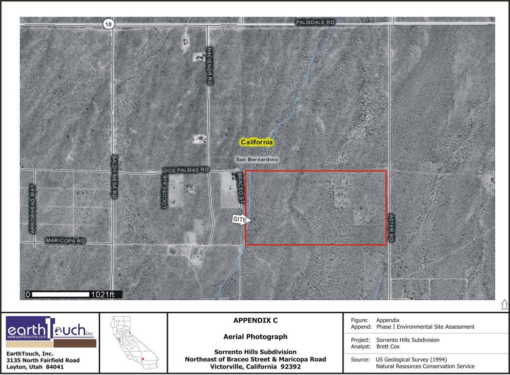
65
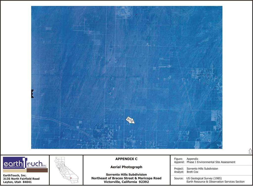
66

67
68
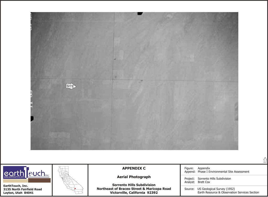
69
70 APPENDIX D HISTORIC TOPOGRAPHIC MAPS
71
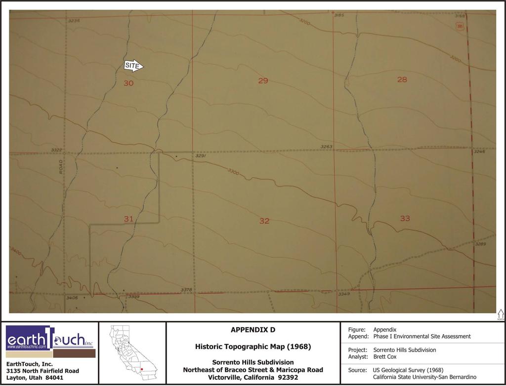
72
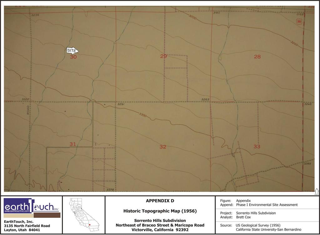
73
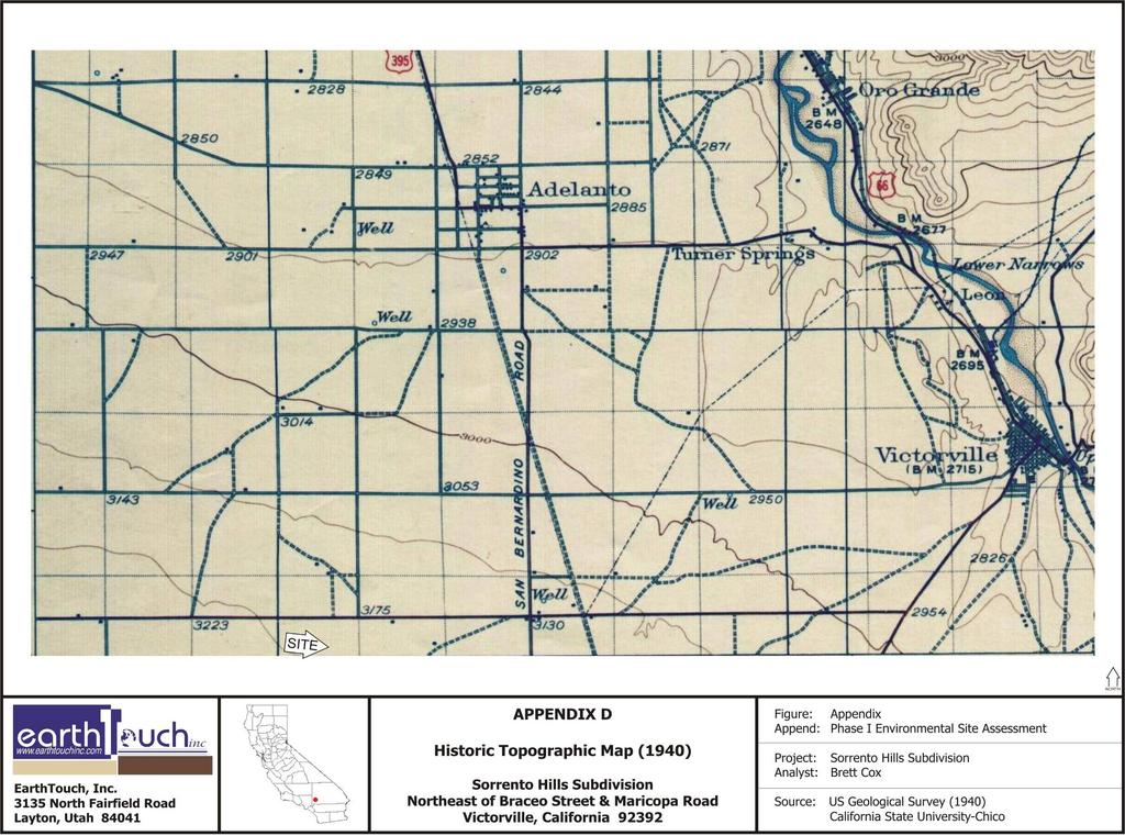
74

75
Environmental Audit Standards
 Environmental Audit Standards Lender requires an acceptable Phase I Environmental Audit Report, directed to Lender and historical in nature, which is to be prepared in accordance with the standards set
PHASE I ENVIRONMENTAL SITE ASSESSMENT
 PHASE I ENVIRONMENTAL SITE ASSESSMENT ACME Gas 55 Garden Street Columbus, Ohio, 45123 Prepared for ACME Oil & Gas Ltd. Prepared by GAEA Environmental Services 87 Garden Street Whitby, Ontario L1N 9E7 November
ENVIRONMENTAL SITE ASSESSMENT (AAI COMPLIANT PHASE I)
") ENVIRONMENTAL SITE ASSESSMENT (AAI COMPLIANT PHASE I) IPP.MORELAND AVENUE ASSEMBLAGE 785-793 MORELAND AVENUE ATLANTA, GEORGIA, 30316 ONE GROUP PROJECT #A6092 JANUARY 28, 2008 PREPARED FOR: FAIRVIEW COMMERCIAL
ENVIRONMENTAL SITE ASSESSMENT (AAI COMPLIANT PHASE I) IPP.MORELAND AVENUE ASSEMBLAGE 785-793 MORELAND AVENUE ATLANTA, GEORGIA, 30316 ONE GROUP PROJECT #A6092 JANUARY 28, 2008 PREPARED FOR: FAIRVIEW COMMERCIAL
PHASE I ENVIRONMENTAL SITE ASSESSMENT REPORT 3.3-ACRE ECKENRODE PROPERTY WARWICK TOWNSHIP, TUSCARAWAS COUNTY, OHIO. Prepared for: OHIOLAND, LLC
 PHASE I ENVIRONMENTAL SITE ASSESSMENT REPORT 3.3-ACRE ECKENRODE PROPERTY WARWICK TOWNSHIP, TUSCARAWAS COUNTY, OHIO Prepared for: OHIOLAND, LLC Prepared by: CIVIL & ENVIRONMENTAL CONSULTANTS, INC. COLUMBUS,
PHASE I ENVIRONMENTAL ENGINEERING PHASE I REPORT 3264 PREPARED FOR: Mark Hopkins. Liberty Real Estate, LLC. 741 North State Road.
 PHASE I ENVIRONMENTAL ENGINEERING PHASE I REPORT 3264 PREPARED FOR: Mark Hopkins Liberty Real Estate, LLC 741 North State Road Salem, Utah 84653 May 25, 2012 SITE LOCATION Hawthorn Mobile Home Park 10682
Proposed Laurel 2 Solar Facility Jessup Road at Vaughn & Diehl Roads Imperial County, California
 Phase I ESA Report Proposed Laurel 2 Solar Facility Jessup Road at Vaughn & Diehl Roads Imperial County, California Prepared for: 9FI 8ME, LLC 221 Sutter Street, 6 th Floor San Francisco, CA 9418 Prepared
Phase I Environmental Site Assessment Update Memorandum Vacant Property 1585 Santa Clara Avenue Santa Ana, California 92507
 March 1, 2011 Mr. Vincent C. Fregoso, AICP City of Santa Ana 20 Civic Center Plaza Santa Ana, CA 92702 Re: Phase I Environmental Site Assessment Update Memorandum Vacant Property 1585 Santa Clara Avenue
DRAFT - Subject to Change. Cathedral Building 212 North Ash Street Crookston, Minnesota. Prepared For. Project FA June 29, 2011
 DRAFT Phase I Environmental Site Assessment Cathedral Building 212 North Ash Street Crookston, Minnesota Prepared For Braun Intertec Corporation Ms. Kay Hegge Prairie Skyline Foundation 27048 310th Street
PHASE I ENVIRONMENTAL SITE ASSESSMENT
 PHASE I ENVIRONMENTAL SITE ASSESSMENT ST. MALACHY PROPERTY, BROWNSBURG HENDRICKS COUNTY, INDIANA Terra Project No. 13-013 Environmental Audit Report Privileged Document PREPARED FOR: Town of Brownsburg
Environmental Questionnaire
 SBA Loan Number: Environmental Questionnaire Applicant Name: of Site Visit: Name/Title of Person Doing Site Visit: Site Name or Business Name: Site Street Address: City, State, Postal Code: County: Site
Real Estate Environmental Questionnaire and Disclosure Statement
 Real Estate Environmental Questionnaire and Disclosure Statement The following pages comprise an Environmental Questionnaire and Disclosure Statement which must be completed by the loan applicant before
PHASE I ENVIRONMENTAL SITE ASSESSMENT 1724 VINTON STREET & 2702 SOUTH 18 TH STREET OMAHA, DOUGLAS COUNTY, NEBRASKA
 PHASE I ENVIRONMENTAL SITE ASSESSMENT 1724 VINTON STREET & 2702 SOUTH 18 TH STREET OMAHA, DOUGLAS COUNTY, NEBRASKA Prepared for: The Estate of George W. Murray & the Omaha Brownfields Coalition Benesch
ENVIRONMENTAL QUESTIONNAIRE AND DISCLOSURE STATEMENT
 ENVIRONMENTAL QUESTIONNAIRE AND DISCLOSURE STATEMENT The purpose of this questionnaire is to provide information about the past and present ownership and uses of the real property upon which lender will
JORDAO PROPERTY ± RIPARIAN IRRIGATED CROPLAND. $2,438,000 ($23,000/Acre)
") JORDAO PROPERTY ±106.00 RIPARIAN IRRIGATED CROPLAND Located at: 7505 Hogin Road Crows Landing, Stanislaus County, CA 95313 APN s 057-026-009 & 057-026-008 Offered for $2,438,000 ($23,000/Acre) Presented
JORDAO PROPERTY ±106.00 RIPARIAN IRRIGATED CROPLAND Located at: 7505 Hogin Road Crows Landing, Stanislaus County, CA 95313 APN s 057-026-009 & 057-026-008 Offered for $2,438,000 ($23,000/Acre) Presented
Voluntary standard; accepted by USEPA to comply with AAI rule. 2. Regulatory/Developmental History
 This table summarizes some of the primary differences between the New Jersey Department of Environmental Protection (NJDEP) Preliminary Assessment Report (PAR), pursuant to the April 2013 NJDEP Site Remediation
SECTION 4: PRELIMINARY PLAT
 SECTION 4: PRELIMINARY PLAT After the completion of the sketch plan process, if submitted, the owner or developer shall file with the City an application for preliminary plat. The preliminary plat stage
BOARD OF REGENTS BRIEFING PAPER. 1. Agenda Item Title: Acquisition of Real Property located at 182 E. 9th Street, Reno NV
 BOARD OF REGENTS BRIEFING PAPER 1. Agenda Item Title: Acquisition of Real Property located at 182 E. 9th Street, Reno NV Meeting Date: September 5 & 6, 2013 2. BACKGROUND & POLICY CONTEXT OF ISSUE: Location
PLANNING BOARD CITY OF CONCORD, NH MINOR SUBDIVISION CHECKLIST
 PLANNING BOARD CITY OF CONCORD, NH MINOR SUBDIVISION CHECKLIST Summary This checklist is intended to assist applicants and design professionals in the preparation of minor subdivision applications for
Standard Practice for Environmental Site Assessments: Phase I Environmental Site Assessment Process 1
 Designation: E1527 13 Standard Practice for Environmental Site Assessments: Phase I Environmental Site Assessment Process 1 This standard is issued under the fixed designation E1527; the number immediately
Change is in the air with regard. feature
 em feature Amy L. Edwards is a partner in the law firm of Holland & Knight LLP, Washington, DC, where she co-chairs the firm s national environmental team. Sarah C. Smith is an associate at Holland & Knight.
Phase I Environmental Site Assessments for Corridors
 Phase I Environmental Site Assessments for Corridors Prepared by: Kimberly Perkins and Jill Biesma 1 Environmental Advisors and Engineers 19211 W. 64 th Terrace, Shawnee, KS 66218 (913) 599-4326 Goal Of
Real Estate Gift Fact Sheet/Gift Proposal
 DONOR INFORMATION Donor Legal Name(s) and Advance ID Number(s): Real Estate Gift Fact Sheet/Gift Proposal Residential Address: Telephone (home): Telephone (business): Fax: E-mail address: GENERAL PROPERTY
CITY OF GROVER BEACH COMMUNITY DEVELOPMENT DEPARTMENT Tentative Map Checklist
 CITY OF GROVER BEACH COMMUNITY DEVELOPMENT DEPARTMENT Tentative Map Checklist The following list includes all of the items you must submit for a complete application. Some specific types of information
SECTION SITE SURVEYS
 PART 1 - GENERAL 1.1 DESCRIPTION SECTION 02 21 00 SPEC WRITER NOTES: 1. Use this section only for NCA projects. 2. Delete between //---// if not applicable to project. Also delete any other item or paragraph
Hazardous Materials in Project Development Additional Guidance
 Hazardous Materials in Project Development Additional Guidance Contents:...2 AASHTO Guidance...3 USDOT Brownfields Guidance...4 ASTM Standard Practices...6 Hazardous Materials in Project Development 1
The University of Texas System Systemwide Policy. Policy: UTS Title. Environmental Review for Acquisition of Real Property. 2.
 1. Title 2. Policy Environmental Review for Acquisition of Real Property Sec. 1 Sec. 2 Policy Statement. It is the policy of The University of Texas System to minimize its potential for exposure to claims
CHECKLIST FOR DEVELOPMENT REVIEW
 CHECKLIST FOR DEVELOPMENT REVIEW Petitions and related documents and plans for land development or other proposals regulated by Title 16 of the Municipal Code (Development Ordinance) and Title 17 of the
Due Diligence & Environmental Compliance Issues for Tribal Energy Projects: Hazardous Waste
 Due Diligence & Environmental Compliance Issues for Tribal Energy Projects: Law Seminars International Seattle, WA October 23, 2007 Connie Sue Manos Martin Hazardous Waste Overview Environmental Due Diligence:
CHAPTER 3 PRELIMINARY PLAT
 10-3-1 10-3-3 SECTION: CHAPTER 3 PRELIMINARY PLAT 10-3-1: Consultation 10-3-2: Filing 10-3-3: Requirements 10-3-4: Approval 10-3-5: Time Limitation 10-3-6: Grading Limitation 10-3-1: CONSULTATION: Each
(b) The location of principal and accessory buildings on the lot and the relationship of each structure to the other.
 The location of principal and accessory buildings on the lot and the relationship of each structure to the other.") ARTICLE XIX SITE PLAN Sec. 20-1900 Site Plan Review Procedure - Intent The site plan review procedures are instituted to provide an opportunity for the Township Planning Commission to review the proposed
ARTICLE XIX SITE PLAN Sec. 20-1900 Site Plan Review Procedure - Intent The site plan review procedures are instituted to provide an opportunity for the Township Planning Commission to review the proposed
Information compiled by: Crossett Economic Development Foundation 125 Main Street, Crossett, AR (870)
") Information compiled by: Crossett Economic Development Foundation 125 Main Street, Crossett, AR 71635 (870) 364-8745 mike@cityofcrossett.net www.considercrossett.net General Information Location of Crossett,
Information compiled by: Crossett Economic Development Foundation 125 Main Street, Crossett, AR 71635 (870) 364-8745 mike@cityofcrossett.net www.considercrossett.net General Information Location of Crossett,
MAJOR SUBDIVISION PRELIMINARY PLAT CHECKLIST
 TOWNSHIP OF EGG HARBOR PLANNING BOARD/ZONING BOARD OF ADJUSTMENT 3515 BARGAINTOWN ROAD EGG HARBOR TOWNSHIP, NJ 08234 MAJOR SUBDIVISION PRELIMINARY PLAT CHECKLIST The following checklist is designed to
Mitigating Risk Through Environmental Due Diligence in California Real Estate Deals
 Mitigating Risk Through Environmental Due Diligence in California Real Estate Deals Kevin C. Mayer Harmon L. (Monty) Cooper Crowell & Moring 1 Outline Why Environmental Due Diligence? I. Purpose II. Roles
SUBDIVISION APPLICATION CHECKLIST SKETCH PLAN PRELIMINARY PLAT FINAL PLAT
 RECEIVED STAMP SUBDIVISION APPLICATION CHECKLIST SKETCH PLAN PRELIMINARY PLAT FINAL PLAT A checklist of background information and submission requirements for processing of a sketch plan, preliminary plat
DUE DILIGENCE. Presented at. Lydia Work, Senior Chemist Licensed Remediation Specialist Triad Engineering, Inc.
 DUE DILIGENCE Presented at Lydia Work, Senior Chemist Licensed Remediation Specialist Triad Engineering, Inc. due dil i gence appropriate carefulness: the degree of care that a prudent person would exercise,
PHASE I ENVIRONMENTAL SITE ASSESSMENT 904, 911 & 1007 South 20 th Street OMAHA, DOUGLAS COUNTY, NEBRASKA
 PHASE I ENVIRONMENTAL SITE ASSESSMENT 904, 911 & 1007 South 20 th Street OMAHA, DOUGLAS COUNTY, NEBRASKA Prepared for: J & C Snelling Properties LLC Benesch Project No. 00120137.00 March 2013 Prepared
APPLICATION SUBMITTAL REQUIREMENTS FOR Tentative Parcel or Subdivision Maps
 CITY OF EL CERRITO Community Development Department Planning and Building Division 10890 San Pablo Avenue, El Cerrito, CA 94530 (510) 215-4330 FA (510) 233-5401 planning@ci.el-cerrito.ca.us APPLICATION
Limited Environmental Due Diligence: Transaction Screen. McCampbell Property San Patricio County
 Limited Environmental Due Diligence: Transaction Screen McCampbell Property San Patricio County 0 LAN_McCampbellProperties_Xstrategic_November,2017 LIMITED ENVIRONMENTAL DUE DILIGENCE Executive Summary
PHASE I ENVIRONMENTAL SITE ASSESSMENT
 PHASE I ENVIRONMENTAL SITE ASSESSMENT SARASOTA CENTER LOTS 141, 1571, 161, AND 515 SARASOTA CENTER BLVD ENGLEWOOD, FLORIDA 34224 SEPTEMBER 21, 212 NOVA PROJECT NO. E12 3583 Leaders in Environmental and
DRAFT FINAL FINDING OF SUITABILITY TO TRANSFER (FOST) Little Patuxent River Parcel. October 16, 2013
 Little Patuxent River Parcel. October 16, 2013") DRAFT FINAL FINDING OF SUITABILITY TO TRANSFER (FOST) Little Patuxent River Parcel October 16, 2013 1. PURPOSE The purpose of this Finding of Suitability to Transfer (FOST) is to document the environmental
DRAFT FINAL FINDING OF SUITABILITY TO TRANSFER (FOST) Little Patuxent River Parcel October 16, 2013 1. PURPOSE The purpose of this Finding of Suitability to Transfer (FOST) is to document the environmental
ARTICLE 7: PLOT PLANS AND SITE PLAN REQUIREMENTS AND REVIEW
 ARTICLE 7: PLOT PLANS AND SITE PLAN REQUIREMENTS AND REVIEW Section 7.0 - Purpose The purpose of this article is to specify the documents and/or drawings required for a Site Plan Review or a Plot Plan
Diamond Falls Subdivision PROPOSED YELLOWSTONE COUNTY BOARD OF PLANNING FINDINGS OF FACT
 Diamond Falls Subdivision PROPOSED YELLOWSTONE COUNTY BOARD OF PLANNING FINDINGS OF FACT The City/County Planning Staff has prepared the Findings of Fact for the Diamond Falls Subdivision. These findings
Concho Wastewater Improvement District ( District ) Customer Rules and Regulations
 Customer Rules and Regulations") Concho Wastewater Improvement District ( District ) Customer Rules and Regulations Approved 5/27/17 1.0 Establishment of Service 1.1 To receive wastewater service from the District, a landowner must execute
Concho Wastewater Improvement District ( District ) Customer Rules and Regulations Approved 5/27/17 1.0 Establishment of Service 1.1 To receive wastewater service from the District, a landowner must execute
Emergency Watershed Program Sandy Recovery Activities and Flood Plain Easement Program
 Emergency Watershed Program Sandy Recovery Activities and Flood Plain Easement Program Greg Westfall, Resource Conservationist USDA-Natural Resources Conservation Service (NRCS) Set up by Congress to respond
Environmental Due Diligence
 2017 NJ Land Conservation Rally Environmental Due Diligence Stephen Kehayes Michelle Slosberg Peter Sorge, LSRP 1. Introduction 2. Due Diligence Process 3. Potential Problems 4. Investigation 5. Regulatory
APPLICATION PROCEDURE
 ANTRIM PLANNING BOARD P. O. Box 517 Antrim, New Hampshire 03440 Phone: 603-588-6785 FAX: 603-588-2969 APPLICATION FORM AND CHECKLIST FOR MINOR OR MAJOR SITE PLAN REVIEW File Date Received By APPLICATION
ARTICLE V PRELIMINARY PLAN SUBMISSION
 ARTICLE V PRELIMINARY PLAN SUBMISSION 501. Plan Requirements a. On or before the 25 th day of the month prior to a regularly scheduled meeting of the Planning Commission, the applicant shall submit two
Initial Subdivision Applications Shall Include the Following:
 Initial Subdivision Applications Shall Include the Following: 1) Subdivision Application Form: completely filled out (12 copies) 2) Plat: The Plat must adhere to the requirements set forth in the Town
Condominium Unit Requirements.
 ARTICLE 19 CONDOMINIUM REGULATIONS Section 19.01 Purpose. The purpose of this Article is to regulate projects that divide real property under a contractual arrangement known as a condominium. New and conversion
Walton County Planning and Development Services
 Walton County Planning and Development Services 31 Coastal Centre Boulevard, Suite 100 47 N 6 th Street Santa Rosa Beach, Florida 32459 DeFuniak Springs, Florida 32433 Phone 850-267-1955 Phone 850-892-8157
Technical Information Paper No
 Environmental Condition of Property (ECOP) Investigations Technical Information Paper No. 38-001-0312 PURPOSE. To provide information on ECOP investigations for Federal real property transactions and military
ENVIRONMENTAL DUE DILIGENCE
 ENVIRONMENTAL DUE DILIGENCE Developing Solar on Landfills & Brownfields June 12-13, 2017 Chicago, Illinois Matthew E. Cohn Greensfelder Hemker & Gale, P.C. 200 West Madison Street Suite 3300 Chicago, Illinois
ANDOVER CODE. Checklist #5 Preliminary Site Plan Conditional Use
 ANDOVER CODE Checklist #5 Preliminary Site Plan Conditional Use Applicant: Block Lot File No. This checklist is for general reference only. Further information may be required by the reviewing authority.
TOWNSHIP OF EGG HARBOR ZONING BOARD ADJUSTMENT CHECK LIST
 TOWNSHIP OF EGG HARBOR ZONING BOARD ADJUSTMENT CHECK LIST Schedule A - General Requirements 1. Where the application involves only a variance one (1) original and nineteen (19) copies of the appropriate
FINAL PLAT SUBMITTAL CHECKLIST
 FINAL PLAT SUBMITTAL CHECKLIST The submission requirements for a Final Plat Review are found beginning in Section 24-4-40 of the Weld County Code. The Weld County Code is available on line at www.co.weld.co.us
BROWNFIELDS Connecticut All Grantee Meeting July Getting the most out of All Appropriate Inquiries (AAI)
") BROWNFIELDS Connecticut All Grantee Meeting July 11 2012 Getting the most out of All Appropriate Inquiries (AAI) 1 AAI in Perspective All Appropriate Inquiries often is a critical step in a continuum of
BROWNFIELDS Connecticut All Grantee Meeting July 11 2012 Getting the most out of All Appropriate Inquiries (AAI) 1 AAI in Perspective All Appropriate Inquiries often is a critical step in a continuum of
The Ranches Sketch Plan
 The Ranches Sketch Plan APPLICATION: RURAL LAND USE PROCESS (AKA CLUSTER DEVELOPMENT) HEARING DATES: Planning Commission: 12 July 2017 at 6:30 pm Board of County Commissioners: TBD APPLICANT: REQUEST:
A.3. ARTICLE 7 PLAN REQUIREMENTS FOR MINOR SUBDIVISION AND/OR LAND DEVELOPMENT
 700. 701.A.3. ARTICLE 7 PLAN REQUIREMENTS FOR MINOR SUBDIVISION AND/OR LAND DEVELOPMENT SECTION 700 PURPOSE The purpose of this Article is to set forth a streamlined set of Plan Requirements for minor
ARTICLE 6 PRELIMINARY PLAT
 ARTICLE 6 PRELIMINARY PLAT SECTION: 30-06-01: Preliminary Plat 30-06-02: Information Required for Preliminary Plat 30-06-03: Determination of Requirement for Environmental Review Documents 30-06-04: Additional
ARTICLE 13 CONDOMINIUM REGULATIONS
 ARTICLE 13 CONDOMINIUM REGULATIONS Section 13.01 Purpose. The purpose of this Article is to regulate projects that divide real property under a contractual arrangement known as a condominium. New and conversion
PRELMINARY PLAT CHECKLIST
 PRELMINARY PLAT CHECKLIST A. All preliminary plat submitted for approval shall be prepared by a Registered Professional Land Surveyor. B. Preliminary plats must be drawn to a scale of XXX with such accuracy
Address Southeast Quadrant of U.S. Highway 41 and Sumter Boulevard City. North Port State. FL Zip Code County
 SUBJECT AERIAL LOCATION LAND AREA THREE-YEAR OWNERSHIP HISTORY OF SUBJECT Address Southeast Quadrant of U.S. Highway 41 and Sumter Boulevard City North Port State FL Zip Code 34287 County Sarasota Nearest
ARTICLE 900 PLAT AND PLAN REQUIREMENTS
 ARTICLE 900 PLAT AND PLAN REQUIREMENTS SEC. 900.1 ITEMS TO BE SHOWN ON PLAT OR PLAN General (1) Property lines of all property owners adjacent to the exterior boundaries of the project shall be located
ARTICLE VI. SUBDIVISION STANDARDS, PUBLIC
 ARTICLE VI. SUBDIVISION STANDARDS, PUBLIC IMPROVEMENTS, AND DESIGN REQUIREMENTS ARTICLE VI. SUBDIVISION STANDARDS, PUBLIC IMPROVEMENTS, AND DESIGN REQUIREMENTS DIVISION 1. GENERAL PROVISIONS Sec. 21-6100.
1976 Fargo, ND City Directory - R.L. Polk & Co.
 1986 Fargo, ND City Directory - R.L. Polk & Co. 1981 Fargo, ND City Directory - R.L. Polk & Co. 1976 Fargo, ND City Directory - R.L. Polk & Co. 1971 Fargo, ND Directory - R.L. Polk & Co. 1971 Fargo, ND
APPENDIX B. SUBMISSION REQUIREMENTS
 Master Major Site Minor Site Landscape Section B.1 Table of /Plat Requirements Proposed or approved name of development, project, subdivision, and/or phase. Location, including township, county, and state.
TARGETED BROWNFIELD ASSESSMENT
 TARGETED BROWNFIELD ASSESSMENT For Oklahoma Army National Guard Former ASTM E 1527-05 Phase I Environmental Site Assessment All Appropriate Inquiry Prepared by: August 17, 2011 Prepared for: The University
GENERAL PLAN, DEVELOPMENT CODE AND ZONING MAP AMENDMENT APPLICATION INFORMATION SHEET
 GENERAL PLAN, DEVELOPMENT CODE AND ZONING MAP AMENDMENT APPLICATION INFORMATION SHEET GENERAL INFORMATION This information sheet explains how an application requesting an amendment to the Truckee General
Concept Plan Project Narrative For 852 River Ranch Court
 Concept Plan Project Narrative For 852 River Ranch Court Date: January 5, 2016 Prepared by: Robert W. Jones II, P.E. Vortex Engineering, Inc. 2394 Patterson Rd., Ste 201 Grand Junction, CO 81505 970-245-9051
MINERAL COUNTY PLANNING STAFF FINDINGS OF FACT Proposed Elk Run at St. Regis. February 12, 2017
 MINERAL COUNTY PLANNING STAFF FINDINGS OF FACT Proposed The proposed is a five-lot subdivision and is located approximately one mile east of St. Regis on Old Highway 10 East. The property is located in
Special Use Permit - Planned Unit Development Checklist. Property Address:
 Special Use Permit - Planned Unit Development Checklist Special Use Permit Number. Parcel Code/s #28-11- - - Property Address: Applicant: ARTICLE VIII Ordinance Reference - Section 8.1.2 Permit Procedures:
ENVIRONMENTAL DISCLOSURE FOR TRANSFER OF REAL PROPERTY (IC ) State Form (R / 1-07) Indiana Department of Environmental Management
 State Form (R / 1-07) Indiana Department of Environmental Management") ENVIRONMENTAL DISCLOSURE FOR TRANSFER OF REAL PROPERTY (IC 13-25-3-7.5) State Form 52653 (R / 1-07) Indiana Department of Environmental Management A WARNING TO THE PARTIES TO A TRANSFER OF PROPERTY: The
ENVIRONMENTAL DISCLOSURE FOR TRANSFER OF REAL PROPERTY (IC 13-25-3-7.5) State Form 52653 (R / 1-07) Indiana Department of Environmental Management A WARNING TO THE PARTIES TO A TRANSFER OF PROPERTY: The
Preliminary Subdivision Application (Minor) (Three (3) lots or less)
 (Three (3) lots or less)") Gunnison City Offices www.gunnisoncity.org 38 West Center Gunnison, Utah 84634 (435) 528 7969 Date of Application: Preliminary Subdivision Application (Minor) (Three (3) lots or less) APPLICANT INFORMATION
Gunnison City Offices www.gunnisoncity.org 38 West Center Gunnison, Utah 84634 (435) 528 7969 Date of Application: Preliminary Subdivision Application (Minor) (Three (3) lots or less) APPLICANT INFORMATION
PRELIMINARY PLAT CHECK LIST
 PRELIMINARY PLAT CHECK LIST Name of Proposed Subdivision: The following items must be included with the initial submittal of a Preliminary Plat: Application, filled out completely Project Narrative Pre-application
Different Levels of Environmental Site Assessment and the Benefits to M&A Due Diligence
 Different Levels of Environmental Site Assessment and the Benefits to M&A Due Diligence A White Paper by Dennis Papa, PE, BCEE, Principal of dpstudio environmental consulting & design LLC November 2016
October 29, 2013 Florida Brownfields Association Conference, Orlando
 Site Inventories October 29, 2013 Florida Brownfields Association Conference, Orlando Andrew M. Lawn, M.S., P.G. Principal Hydrogeologist Holden Heights Areas HSW & Orange County Environmental Protection
610 LAND DIVISIONS AND PROPERTY LINE ADJUSTMENTS OUTSIDE A UGB
 ARTICLE VI: LAND DIVISIONS AND PROPERTY LINE ADJUSTMENTS VI-21 610 LAND DIVISIONS AND PROPERTY LINE ADJUSTMENTS OUTSIDE A UGB 610-1 Property Line Adjustments (Property Line Relocation) A property line
Moore Township Planning Commission 2491 Community Drive, Bath, Pennsylvania Telephone: FAX: Rev:12/23/2013
 2491 Community Drive, Bath, Pennsylvania Telephone: 610-759-9449 FAX: 610-759-9448 Rev:12/23/2013 APPLICATION FORM FOR A SITE PLAN PER MOORE TOWNSHIP ZONING ORDINANCE SECTION 200-58.1 NORTHAMPTON COUNTY,
PHASE I ENVIRONMENTAL SITE ASSESSMENT SOUTH OMAHA TERMINAL WAREHOUSE 4913 SOUTH 27 th STREET OMAHA, DOUGLAS COUNTY, NEBRASKA
 PHASE I ENVIRONMENTAL SITE ASSESSMENT SOUTH OMAHA TERMINAL WAREHOUSE 4913 SOUTH 27 th STREET OMAHA, DOUGLAS COUNTY, NEBRASKA Prepared for: South Omaha Terminal Warehouse & the Omaha Brownfields Coalition
New Phase I Requirements for Real Estate Transactions: Implications of the New All Appropriate Inquiries Rule
 New Phase I Requirements for Real Estate Transactions: Implications of the New All Appropriate Inquiries Rule Helen Currie Foster Graves, Dougherty, Hearon & Moody, P.C. 1 State Bar of Texas 28 th Annual
BRIDGETON SUBDIVISION APPLICATION CHECKLIST
 APPLICATION NAME AND # CHECKLIST COMPLETED BY: DATE: Signature and printed name BRIDGETON SUBDIVISION APPLICATION CHECKLIST TO SUBDIVISION APPLICANTS: The attached checklist is to assist you in the submission
New Electronic Planning Commission Submittal Process
 New Electronic Planning Commission Submittal Process STANDARD OPERATING PROCEDURE Purpose: To outline the electronic submittal process for applications to the Planning Commission. Background: Procedure:
DIVISION 2 - CONSTRUCTION PLAN AND MISCELLANEOUS REQUIREMENTS
 DIVISION 2 - CONSTRUCTION PLAN AND MISCELLANEOUS REQUIREMENTS 2.1 Required Plan Sheets 2.2 Drawing Requirements 2.3 Graphic Standards 2.4 Easements 2.5 Utility Locations 2.6 Private Facility Locations
Letter of Intent May 2017 (Revised November 2017)
") THE BEACH AT WOODMOOR LETTER OF INTENT MAY 2017 (REVISED NOVEMBER 2017) OWNER/APPLICANT: CONSULTANT: Lake Woodmoor Holdings LLC N.E.S. Inc. 1755 Telstar Drive, Suite 211 619 North Cascade Avenue Colorado
THE BEACH AT WOODMOOR LETTER OF INTENT MAY 2017 (REVISED NOVEMBER 2017) OWNER/APPLICANT: CONSULTANT: Lake Woodmoor Holdings LLC N.E.S. Inc. 1755 Telstar Drive, Suite 211 619 North Cascade Avenue Colorado
COUNTY OF RIVERSIDE TRANSPORTATION AND LAND MANAGEMENT AGENCY DEVELOPMENT MANUAL
 COUNTY OF RIVERSIDE TRANSPORTATION AND LAND MANAGEMENT AGENCY DEVELOPMENT MANUAL Created: 8/31/04 Revised: 1/17/06 Table of Contents Section Page 1. Introduction and General Provisions...1 1.1 Purpose...1
Ontario Ministry of the Environment and Climate Change - Record of Site Condition #
 Ontario Ministry of the Environment and Climate Change - Record of Site Condition # 218489 Record of Site Condition Under Part XV.1 of the Environment Protection Act Summary Record of Site Condition Number
Preliminary Subdivision Application (Major) (Four (4) lots or more)
 (Four (4) lots or more)") Gunnison City Offices www.gunnisoncity.org 38 West Center Gunnison, Utah 84634 (435) 528 7969 Date of Application: Preliminary Subdivision Application (Major) (Four (4) lots or more) APPLICANT INFORMATION
Gunnison City Offices www.gunnisoncity.org 38 West Center Gunnison, Utah 84634 (435) 528 7969 Date of Application: Preliminary Subdivision Application (Major) (Four (4) lots or more) APPLICANT INFORMATION
TOWN OF BRISTOL. Ontario County, New York APPLICATION FOR LOT LINE ADJUSTMENT
 TOWN OF BRISTOL Ontario County, New York APPLICATION FOR LOT LINE ADJUSTMENT Lot Line Adjustment: The adjusting of common property line(s) or boundaries between adjacent lots, tracts, or parcels for the
149(+/-) Acres. Prime Location Development Opportunity. Partially Completed. 260 Shepherd of the Hills Expressway Branson Mo
 Acres. Prime Location Development Opportunity. Partially Completed. 260 Shepherd of the Hills Expressway Branson Mo") Price Reduced!! 149(+/-) Acres Prime Location Development Opportunity Partially Completed 260 Shepherd of the Hills Expressway Branson Mo Attention Developers! Bank owned 149(+/-) acres in town! Partially
Price Reduced!! 149(+/-) Acres Prime Location Development Opportunity Partially Completed 260 Shepherd of the Hills Expressway Branson Mo Attention Developers! Bank owned 149(+/-) acres in town! Partially
CHAPTER 26 PLANNING AND ZONING ARTICLE VII. MOBILE HOMES AND RECREATIONAL VEHICLE (RV) PARKS. Recreational Vehicle (RV) Park Development Standards
 PARKS. Recreational Vehicle (RV) Park Development Standards") CHAPTER 26 PLANNING AND ZONING ARTICLE VII. MOBILE HOMES AND RECREATIONAL VEHICLE (RV) PARKS. Section 26-VII-1. Section 26-VII-2. Section 26-VII-3. Section 26-VII-4. Section 26-VII-5. Purpose Permitted
CHAPTER 26 PLANNING AND ZONING ARTICLE VII. MOBILE HOMES AND RECREATIONAL VEHICLE (RV) PARKS. Section 26-VII-1. Section 26-VII-2. Section 26-VII-3. Section 26-VII-4. Section 26-VII-5. Purpose Permitted
Section Preliminary Plat Checklist and Application Forms
 Section 201 - Preliminary Plat Checklist and Application Forms PRELIMINARY SUBDIVISION PLAT REVIEW PROCESS CHART PRELIMINARY SUBDIVISION PLAT APPLICATION PRELIMINARY PLAT REVIEW CHECKLIST CITY OF NAMPA
PHASE I ENVIRONMENTAL SITE ASSESSMENT AXLES AND GEARS TRUCK PARTS WAREHOUSE 4808 SOUTH 26 TH STREET OMAHA, DOUGLAS COUNTY, NEBRASKA
 PHASE I ENVIRONMENTAL SITE ASSESSMENT AXLES AND GEARS TRUCK PARTS WAREHOUSE 4808 SOUTH 26 TH STREET OMAHA, DOUGLAS COUNTY, NEBRASKA Prepared for: Axles and Gears, Inc. & the Omaha Brownfields Coalition
Attached is a Clinton Township Zoning Permit Application and requirements for issuance of a permit.
 To Whom It May Concern: Attached is a Clinton Township Zoning Permit Application and requirements for issuance of a permit. The fee for the permit application is $75.00, which shall be made payable to
WASCO COUNTY PRELIMINARY SUBDIVISION APPLICATION
 WASCO COUNTY PRELIMINARY SUBDIVISION APPLICATION DETAILED SPECIFIC WRITTEN REQUEST File Number: SDV- Number of Proposed Lots & their Dimensions: PRELIMINARY SUBDIVISION PLAN REQUIREMENTS The approval of
SUBMITTAL REQUIREMENTS: The number indicates the number of copies for submittal (if applicable).
.") Office Use Only Preliminary Long Plat Long Subdivision Applicant Checklist PLANNING, COMMUNITY, & ECONOMIC DEVELOPMENT DEPARTMENT PRELIMINARY LONG PLAT LONG SUBDIVISION CHECKLIST Mailing Address: P.O.
Office Use Only Preliminary Long Plat Long Subdivision Applicant Checklist PLANNING, COMMUNITY, & ECONOMIC DEVELOPMENT DEPARTMENT PRELIMINARY LONG PLAT LONG SUBDIVISION CHECKLIST Mailing Address: P.O.
MTC ALABAMA SUBDIVISION
 # 2 SUB-000370-2017 MTC ALABAMA SUBDIVISION Engineering Comments: FINAL PLAT COMMENTS (should be addressed prior to submitting the FINAL PLAT for review and/or signature by the City Engineer): A. Provide
COMMUNITY DEVELOPMENT DEPARTMENT 333 Broadalbin Street SW, P.O. Box 490 Albany, OR 97321
 COMMUNITY DEVELOPMENT DEPARTMENT 333 Broadalbin Street SW, P.O. Box 490 Albany, OR 97321 Ph: 541-917-7550 Fax: 541-917-7598 www.cityofalbany.net STAFF REPORT Application for Site Plan Review SP-07-18 and
Residential Minor Subdivision Review Checklist
 Residential Minor Subdivision Review Checklist Plan Submittal Requirements: 2 full sets of stamped plans Electric submittal - all plans contained in a single PDF 3 full sets if commercial kitchen or dining
Appendix A. Definitions
 Definitions 1. Terms Defined. Words contained in this are those having a special meaning relative to the purposes of this Ordinance. Words not listed in this section shall be defined by reference to: (1)
géãç Éy VtÇtÇwt zât 5440 Routes 5 & 20 West Canandaigua, NY Phone: (585) / Fax: (585)
 / Fax: (585)") géãç Éy VtÇtÇwt zât 5440 Routes 5 & 20 West Canandaigua, NY 14424 Phone: (585) 394-1120 / Fax: (585) 394-9476 NOTICE TO ALL PLANNING BOARD APPLICANTS FOR PRELIMINARY SUBDIVISION PHASED PROJECTS The applicant
géãç Éy VtÇtÇwt zât 5440 Routes 5 & 20 West Canandaigua, NY 14424 Phone: (585) 394-1120 / Fax: (585) 394-9476 NOTICE TO ALL PLANNING BOARD APPLICANTS FOR PRELIMINARY SUBDIVISION PHASED PROJECTS The applicant